WBBSE Solutions For Class 6 Geography Chapter 10 Our Country India Topic F Forests And Wildlife Of India

WBBSE Chapter 10 Our Country India Topic F Forests And Wildlife Of India Long Answer Type Questions

Question 1. What are the characteristics of a national park?
Answer:

The characteristics of a National Park, as specified by the IUCN are as follows—

  1. A National Park is an ecosystem substantially unchanged by human interference, where the flora, the fauna, and the specific landforms are of special interest.
  2. It is also protected from industrialization and population.
  3. It must be of a minimum size of 1000 hectares, where natural protection holds the highest priority.
  4. The demarcated area is owned by the national government.
  5. Visitors are allowed for camping and outdoor activities.
  6. Ban on the exploitation of natural resources.
  7. National Parks are designated by the IUCN under its category II protected area.

Question 2. What is meant by wildlife?
Answer:

Wildlife:

Wildlife is a collection of natural fauna and sometimes flora of a region that grows and survives without human interference.

Wildlife is a basic part of any ecosystem, but if not protected with the care it may even lead to an imbalance in the respective ecosystems.

It is an essential duty of a country, state, region, or community to work toward the protection of the wildlife of that region.

Question 3. What is meant by a Reserved Forest?
Answer:

Protected Forest:

A forest in which hunting, grazing, and other human activities are prohibited is known as a Reserved Forest. It is a protected forest area under the Indian Forest Act, of 1927.

A reserved forest enjoys greater security as compared to other protected forests. For example, Tikarapada Reserved Forest in Odisha.

Short Questions on Forests and Wildlife of India

Question 4. What Is meant by a Protected Forest?
Answer:

Protected Forest:

A forest in which rights of activities like hunting and grazing are allowed to a certain extent to communities dependent on them is known as a Protected Forest.

Protected Forest is conferred with a limited amount of protection under the Indian Forest Act, of 1927.

Protected forests are of two types demarcated protected forests and un-demarcated Protected forests.

WBBSE Solutions For Class 6 Geography Chapter 10 Our Country India Topic F Forests And Wildlife Of India

Question 5. What is meant by a Sanctuary?
Answer:

Sanctuary:

A Sanctuary is a place, protected by law, in which endangered birds and other animals are safe from being hunted, killed, or poached.

Here, they can live and breed without interference in a forest a large area with thick clusters of different species of trees and undergrowth.

The animals and birds living in a forest are completely dependent on the forest for their habitats and surroundings.

Ranganthittu Bird Sanctuary in Karnataka and Bethuadahari wildlife sanctuary in West Bengal are popular Sanctuaries in India.

Question 6. What is meant by a National Park?
Answer:

National Park:

A National Park refers to a large tract of natural land set aside by the national government for the preservation of its natural environment.

The landscapes with their plants and animals are preserved in their natural state. It comes under IUCN category II protected areas and is generally open for camping and outdoor recreation for visitors.

Jim Corbett National Park is known to be the first National Park in India.

Common Questions About Indian Wildlife

Question 7. What is meant by a Zoological park?
Answer:

Zoological park:

An area of land or a place where various species of birds are protected from humans, other animals, and other predatory birds to conserve their natural habitat and promote their rehabilitation and survival.

Here, the birds are also encouraged to breed. Generally, various species of birds are given shelter and the place is open to visitors.

Bharatpur Bird Sanctuary in Rajasthan; Ranganthittu Bird Sanctuary in Karnataka and Kulik Bird Sanctuary in West Bengal are examples of well-known Bird Sanctuaries in India.

Question 8. What is meant by a Zoological Park?
Answer:

Zoological Park:

A Zoological Park is a park or an establishment where living animals are kept within enclosures for tourist attraction and may even serve as a purpose of the study.

Living animals are also bred here. The word ’zoological’ is derived from the Greek words ’zoon’ meaning animal and ‘logia’ meaning the study of. Nandankanan Zoological Park, Odisha; and Alipore Zoological Garden, Kolkata, West Bengal are two famous zoos in India.

Question 9. What is meant by a Botanical Garden?
Answer:

Botanical Garden:

A garden entirely devoted to the cultivation, collection, and display of a variety of plants and trees tagged with their botanical names is known as a botanical garden.

A botanical garden may be specific to a certain kind of plant (for example, medicinal or herb) or from a specific plant of the world.

In many botanical gardens, greenhouses are utilized to grow special groups of plants. Visitors can go on educational exhibitions, and tours and also see the library (botanical) facilities.

Acharya Jagadish Chandra Bose Indian Botanic Garden in West Bengal, Lalbagh Botanical Garden in Karnataka and Empress Botanical Garden in Maharastra are some important Botanical Gardens in India.

Practice Questions on Endangered Species in India

Question 10. What is Wildlife Protection Act?
Answer:

Wildlife Protection Act:

The law introduced by the Government of India on September 9, 1972, for the protection of wildlife, is called the Wildlife Protection Act.

Aim: The main aim of this law is to protect wildlife, birds, and forests.

Rule of law: If one breaks the law, he will be punished according to Indian Penal Code.

Observation: In India, the first week of October (1st to 7th) is observed as Wildlife Week every year.

WBBSE Chapter 10 Our Country India Topic F Forests And Wildlife Of India Short Answer Type Questions

Question 1. What is meant by a forest?
Answer:

Forest:

A forest is a large area with a thick cluster of different species of trees and undergrowth.

The animals and birds living in a forest are completely dependent on the forest for their food and habitat. It is a region rich in biodiversity.

Question 2. What are migratory birds?
Answer:

Migratory birds:

In winter, some birds fly from cold countries to our country. When the summer is about to begin, they go back to their country. These birds are called migratory birds.

Examples: Siberian storks, Hooping storks, Golden Clover, and Puffins from the Siberian region of Russia.

Question 3. Why do we need to conserve wildlife?
Answer:

The reasons for which we need to conserve wildlife are listed below—

  1. To protect the various species of flora and fauna and their respective breeding areas and habitats.
  2. To protect the natural beauty of the forest land and conserve the endangered species.
  3. To protect and preserve various flora and fauna, which in turn help to preserve the local ecosystem.

Important Definitions Related to Indian Forests

Question 4. List the various methods to conserve wildlife.
Answer:

The various methods to conserve wildlife are as follows—

  1. Ensuring a protected habitat for wildlife.
  2. Protect wildlife from poachers.
  3. To reduce the threat to endangered species.

Question 5. Name some of the Reserved Forests in India.
Answer:

The following are some of the important Reserved Forests in India—

  1. Annekal Reserved Forest, Western Ghats
  2. Banni Grasslands Reserve, Gujarat
  3. Jakanari Reserve Forest
  4. Tamil Nadu
  5. Kukrail Reserve Forest,
  6. Uttar PradeshJogimatti Reserve Forest,
  7. Karnataka.

Question 6. Name some of the Wildlife Sanctuaries in India.
Answer:

The following are some of the important Wildlife Sanctuaries in India—

  1. Koderma Wildlife Sanctuary, Jharkhand
  2. Dandeli Wildlife Sanctuary, Karnataka
  3. Koyna Wildlife Sanctuary, Maharashtra
  4. Chilika Bird Sanctuary, Odisha
  5. Bethuadahari Wildlife Sanctuary, West Bengal.

Question 7. Name some of the National Parks in India.
Answer:

The following are some of the most important National Parks in India—

  1. Jim Corbett National Park,
  2. Uttarakhand (the first designated National Park in India).
  3. Simlipal National Park,
  4. Odisha; Kaziranga National Park,
  5. Assam; Kanha National Park,
  6. Madhya Pradesh;
  7. Gorumara National Park, West Bengal.

Conceptual Questions on Biodiversity in Indian Forests

Question 8. Name some of the National Parks in West Bengal.
Answer:

The following are some of the most important national parks in West Bengal—

  1. Gorumara National Park, Jalpaiguri;
  2. Neora Valley National Park,
  3. Kalimpong; Singalila National Park,
  4. Darjeeling; Sunderban National Park,
  5. South 24 Parganas; Jaldapara National Park, Alipurduar.

Question 9. Differentiate between Reserved Forest and Protected Forest.
Answer:

The difference between Reserved Forest and Protected Forest are as follows—

WBBSE Solutions For Class 6 Geography Chapter 10 Our Country India Topic F Forests And Wildlife Of India reserved and protected forest

WBBSE Class 6 Forests and Wildlife Notes

Question 10. Differentiate between Wildlife Sanctuary and National Park
Answer:

The differences between Wildlife Sanctuary and National Park are as follows—

WBBSE Solutions For Class 6 Geography Chapter 10 Our Country India Topic F Forests And Wildlife Of India wildlife sanctuary and national park

WBBSE Chapter 10 Our Country India Topic F Forests And Wildlife Of India Very Short Answer Type Questions

Question 1. What is the most important resource of a forest?
Answer: Wood.

Question 2. Expand IUCN.
Answer: International Union for Conservation of Nature.

Question 3. In which month is ‘Wildlife Week’ observed in India?
Answer: October (2-8).

Question 4. Which forest in Gujarat is famous for its lions?
Answer: Gir.

Question 5. In which type of forest is hunting completely prohibited?
Answer: Reserved Forest.

WBBSE Chapter 10 Our Country India Topic F Forests And Wildlife Of India Fill in the blanks

Question 1. The variety of plants and animals in the world is known as____________________
Answer: Biodiversity

Question 2. ____________________ Forest is India’s largest wildlife conservation center.
Answer: Gir National Park

Question 3. ____________________ birds fly down to our country in the winter months from cold countries.
Answer: Migratory

Question 4. The full form of WWF is ____________________
Answer: World wildlife fund

Question 5. ____________________ is the only means of traveling in deserts.
Answer: Camel

Question 6. Dolphins belong to the ____________________ family.
Answer: Mammal

Question 7. Snakes belong to the ____________________ family.
Answer: Reptile

Question 8. Ranthambore National Park is famous for being a safe home to ____________________
Answer: Tigers

Question 9. Earth Day is observed every year on ____________________ April.
Answer: 22

Question 10. The Wildlife Protection Act Law was introduced in the year ____________________
Answer: 1972

WBBSE Chapter 10 Our Country India Topic F Forests And Wildlife Of India Write True Or False

Question 1. Royal Bengal Tiger is an extinct species.
Answer: False

Question 2. Royal Bengal Tiger can be spotted in the Gir forest of Gujarat.
Answer: False

Question 3. Anaconda is the world’s largest-known snake.
Answer: False

Question 4. Earth Day was observed for the first time on 22nd April 1970.
Answer: True

Question 5. The United Nations Conference on Human Environment, 1972 was held in Stockholm.
Answer: True

Question 6. Puffin is a kind of migratory bird.
Answer: True

Question 7. Bhitarkanika National Park in Odisha is famous for bison.
Answer: False

Question 8. Mudumalai National Park is one of the most well-known sanctuaries in Gujarat.
Answer: False

Question 9. Bethuadahari in the Nadia district of West Bengal is noted for its deer population.
Answer: True

Question 10. The crocodile population is a major attraction at Jaldapara National Park.
Answer: False

WBBSE Chapter 10 Our Country India Topic F Forests And Wildlife Of India Match The Columns

Question 1.

WBBSE Solutions For Class 6 Geography Chapter 10 Our Country India Topic F Forests And Wildlife Of India match the following
Answer: 1-B,2-D,3-C,4-E,5-A

WBBSE Solutions For Class 6 Geography Chapter 10 Our Country India Topic E Natural Vegetation Of India

WBBSE Chapter 10 Our Country India Topic E Natural Vegetation Of India Long Answer Type Questions

Question 1. There is much diversity in natural vegetation in different places in India. Why is it so? Or, Why are there variations among the natural vegetation of different regions in India?
Answer:

Given:

There is much diversity in natural vegetation in different places in India.

Based on rainfall, altitude and temperature of different regions, variations are found among natural vegetation of different regions.

For example- Evergreen forests are found in regions (Andaman and Nicobar Islands, the western slopes of the Western Ghats, etc.)

that receive more than 200 cm of annual rainfall whereas deciduous forests are found in regions that receive 100-200 cm of annual rainfall and no rainfall in winter.

Thorny bushes and shrubs are found in the regions (Rajasthan, Gujarat) which receive an annual rainfall of less than 50 cm. Variations in rainfall and temperature are found with the rise in altitude.

As a result, deciduous forests are found at an altitude of 1,000-2,000 metres, coniferous forests are found at an altitude of 2,000-4,000 metres and alpine grasslands grow at an altitude more than 4,000 metres above sea level. Mangroves are found in coastal saline soils.

Question 2. Classify the different types of natural vegetation found in India.
Answer:

The various types of natural vegetation found in India are-

WBBSE Solutions For Class 6 Geography Chapter 10 Our Country India Topic E Natural Vegetation Of India natural vegetation

WBBSE Solutions For Class 6 Geography Chapter 10 Our Country India Topic E Natural Vegetation Of India natural vegatation of indiaWBBSE Solutions For Class 6 Geography Chapter 10 Our Country India Topic E Natural Vegetation Of India natural vegetation.2

WBBSE Class 6 Natural Vegetation Notes

Question 3. Forests are our friends’-Explain. Or, Why should we conserve forests?
Answer:

We regard forests as our friends because-

Trees absorb harmful carbon dioxide and release purified oxygen in the air which is essential for life on Earth.

Plants help in causing rainfall by increasing the amount of water vapour in the atmosphere through transpiration. Plants prevent soil erosion.

The roots bind the soil very firmly and prevent it from being washed away. Trees provide resources such as honey, wax, gum, resin, fruits, flowers and wood.

Forests are home to diverse organisms and plants. Forest wood is used as a raw material for paper, rayon and other handicraft industries. Forests prevent the extension of deserts, increase the fertility of the soil and also help to maintain the ecological balance.

WBBSE Solutions For Class 6 Geography Chapter 10 Our Country India Topic E Natural Vegetation Of India

Question 4. Write the steps you would take to save forests.
Answer:

The steps you would take to save forests:

If we do not save forests, the ecological balance of our earth will be disturbed and this will affect our survival. We can take the following steps to save the forests-

Afforestation and restriction of the felling of trees:

Planting trees in bare lands near rivers, ponds, railway tracks, roads, bare land around our houses, playgrounds and other places where plants can be grown. Only mature trees should be felled and cutting of immature trees should be prohibited.

Resisting deforestation: It is advisable to cut as few trees as possible.

Restricted grazing: Grazing has negative effects on vegetation. Grazing should be on specific grasslands. There should be bans on grazing in forests.

Appointment of forest rangers: There should be rangers in forests to protect forest resources and wildlife.

Increasing awareness: Natural vegetation is important to us. Everyone should be aware of the need for the conservation of trees and forest resources from childhood. Special measures should be taken to create awareness about the preservation of greenery.

Question 5. Discuss the various medicinal plants.
Answer:

The various medicinal plants are as follows-

WBBSE Solutions For Class 6 Geography Chapter 10 Our Country India Topic E Natural Vegetation Of India names of the plants

Types of Natural Vegetation in India

Question 6. How do certain plants remain evergreen throughout the year? Or, Why do leaves remain green throughout the year?
Answer:

Certain plants remain evergreen throughout the year because they grow in areas with heavy rainfall.

The annual rainfall ranges between 200 cm and above, so the soil of that area always remains moist and the supply of water for the plants remains constant.

The annual average temperature ranges between 25°C-35°C. Thus, the plants thrive in conditions with adequate temperature and rainfall.

Also, instead of a particular season, these plants lose their leaves throughout the year, and so, retain an evergreen appearance throughout the year.

Question 7. List a few reasons for the destruction of forests.
Answer:

The following are a few reasons for the destruction of forests—

  1. Forests are destroyed due to the illegal felling of trees for fuel wood or for the paper industry.
  2. The expense of agricultural land is another reason for deforestation.
  3. Forests are also destroyed for jhum cultivation and excessive cattle grazing.
  4. A natural cause of the destruction of forests is forest fires.

Question 8. Discuss the various steps taken for forest conservation.
Answer:

Forests play a vital role in maintaining the ecological balance of a region and that of the entire world.

Forests are also important for the economic development of a country.

So, the following steps are taken for conservation of the forest resources—

1. Plantation of trees: Measures are being taken to increase the number of plants by planting trees in different places like schools, riversides, and temples and then, protecting them from grazing animals.

2. Implementation of law: The government is implementing various laws to resist deforestation and strict monitoring of entry into and exit from forests is done to restrict the activity of wood-smugglers.

3. Others: It is possible to conserve forests by protecting old forestlands, planting trees on barren wastelands, tackling forest fires resisting the attack of disease-spreading organisms, and giving importance to social and agriculture afforestation.

Important Definitions Related to Natural Vegetation

Question 9. Greenery is gradually being lost. State why.
Answer:

Loss of greenery means loss of trees.

Reasons for the loss of greenery are—

  1. Unscientific deforestation.
  2. Smuggling of priceless products of the forests.
  3. The increasing population puts pressure on land, thus causing the destruction of forests.
  4. Deforestation for accumulation of industrial raw materials.
  5. Miles and miles of forests are scorched and destroyed because of forest fires.
  6. Forests are being destroyed because of nuclear bombing.

Question 10. What is natural vegetation? What are the optimum conditions of temperature and rainfall needed for the growth of natural vegetation?
Answer:

Natural vegetation:

The vegetation which grows naturally and sustains in a region without any human interference is known as natural

A minimum temperature of 16°C is required for the growth of natural vegetation. The desirable rate of growth of a plant occurs in temperatures ranging from 28°C-30°C. The amount of rainfall is different in different climatic zones.

The amount of annual rainfall is more than 200 cm in equatorial regions and in desert areas, the annual rainfall is less than 25 cm. A minimum of 50 cm of rainfall annually is required for the growth of natural vegetation.

Question 11. Evergreen vegetation is found in equatorial climates. Give a reason why.
Answer:

Evergreen vegetation is found in equatorial climates:

The climate of equatorial regions is warm and humid. Rainfall and temperature are the two main factors responsible for the growth of a plant.

The temperature of the equatorial region always remains high (25°C-35°C), and this region also receives heavy rainfall (150-200 cm annually).

Soil always remains moist due to heavy rainfall and there is the presence of sufficient humidity. Plants remain evergreen in this region because of the sufficient amount of water, temperature and humidity.

Question 12. What do you get from natural vegetation?
Answer:

The benefits of natural vegetation are as follows—

Natural vegetation absorbs carbon dioxide from the atmosphere and releases oxygen into the atmosphere during photosynthesis. Oxygen is important for the survival of all animal species in the world.

Vegetation cover adds moisture to the atmosphere, which helps to cause rainfall, and checks floods and droughts. It also provides shade during hot summers.

It provides food and fuel wood.

It provides raw materials to the wood industry and paper industries. 0 It reduces soil erosion and renders habitat to birds and animals.

Question 13. What is forest conservation?
Answer:

Forest conservation:

Forest conservation means the protection of forests as well as using forest resources in a sustainable way so that they will remain available for future generations.

While forest products are important to foster economic development, we must remember that forests play a vital role in maintaining the ecological balance of the region and the entire world.

So, proper forest conservation that takes care of both aspects is very important today.

WBBSE Chapter 10 Our Country India Topic E Natural Vegetation Of India Short Answer Type Questions

Question 1. Write the features of the vegetation of Tropical evergreen forests.
Answer:

The following features are found in the vegetation of Tropical evergreen forests—

  1. The trees remain green throughout the year.
  2. They are very tall and often play the role of host to climbers on their trunks and branches.
  3. They yield very hard and heavy wood. O The roots of the trees are very thick.

Short Questions on Natural Vegetation

Question 2. Write the features of the vegetation of Tropical deciduous forests.
Answer:

The features of Tropical deciduous forests are—

  1. The plants lose their leaves in the dry season (winter).
  2. The plants attain a height of 30-50 metres.
  3. The plants do not grow very close to each other.
  4. The trunks are very soft and are used as raw materials for lumbering.

Question 3. Deciduous vegetation is found in seasonal climatic regions. Give a reason why.
Answer:

Deciduous vegetation is found in seasonal climatic regions.

Seasonal climatic regions receive rainfall only in the rainy season, there is no rainfall in winter. Plants of this region shed their leaves in the dry season to prevent transpiration.

For these reasons, deciduous trees grow in seasonal climatic regions. Sal, Teak, and Pipal are some examples of deciduous trees.

Question 4. What are the features of vegetation found in hot desert regions?
Answer:

Generally, thorny bushes and shrubs are found in desert regions.

Their features are—

  1. The leaves are modified into thorns and in some cases, the leaves are very small so as to prevent transpiration from the surface of the leaves.
  2. The stems are covered with a waxy coating.
  3. The roots grow deep into the soil to collect water.

Practice Questions on Forest Types in India

Question 5. The leaves of the plants found in desert regions are modified into spines or thorns. Why?
Answer:

The leaves of the plants found in desert regions are modified into spines or thorns.

The amount of rainfall is very low in desert areas (average 25-50cm). But the temperature is very high (about 35°C-40°C).

The moisture content of the soil is very low in this dry-hot climate because of which roots are very long and grow deep into the soil in order to collect water.

To prevent the loss of water, leaves become very small and are often modified into spines or thorns. This is the main adaptive feature of desert plants.

Question 6. Discuss the features of conifers.
Answer:

The features of conifers are—

  1. Conifers are cone-shaped tall trees.
  2. The leaves are needle-shaped which prevents the accumulation of snow on them.
  3. The stems of the trees yield softwood.

Question 7. What type of climate is required for the growth of evergreen and coniferous vegetation?
Answer:

Minimum temperatures of 25°C-35°C/ more than 200cm annual rainfall and 60%-75% humidity are required for the growth of evergreen vegetation.

Coniferous vegetation grows in temperate regions. These regions receive about 50-100 cm of annual rainfall and may receive snowfall in winter. The average annual temperature is around 15°C.

Question 8. Differentiate between evergreen and deciduous vegetation.
Answer:

The differences between evergreen and deciduous vegetation are as follows—

WBBSE Solutions For Class 6 Geography Chapter 10 Our Country India Topic E Natural Vegetation Of India point of diffrences evergreen deciduous vegetation

Question 9. Differentiate between coastal vegetation and desert vegetation.
Answer:

The differences between coastal vegetation and desert vegetation are as follows—

WBBSE Solutions For Class 6 Geography Chapter 10 Our Country India Topic E Natural Vegetation Of India point of diffrences Coastal vegetation and desert vegatation

Conceptual Questions on Conservation of Forests in India

Question 10. Write the differences between evergreen and coniferous vegetation.
Answer:

The differences between evergreen and coniferous vegetation are as follows—

WBBSE Solutions For Class 6 Geography Chapter 10 Our Country India Topic E Natural Vegetation Of India point of difference evergreen and coniferous vegetation

Question 11. Write the differences between stilt root and breathing root.
Answer:

The difference between stilt root and breathing root are as follows—

WBBSE Solutions For Class 6 Geography Chapter 10 Our Country India Topic E Natural Vegetation Of India point of diffrences slit root and breathing root

Question 12. What do you think are the ill effects of cutting down trees?
Answer:

A few ill effects of cutting down trees or deforestation on the environment are—

  1. Increase in the amount of carbon dioxide in the environment and decrease in the amount of oxygen.
  2. Increase in the rate of soil erosion.

Question 13. Name the types found In India.
Answer:

There are five major types of natural vegetation in India.

They are—

  1. Tropical evergreen vegetation,
  2. Tropical deciduous vegetation,
  3. Thorny bushes and shrubs,
  4. Coastal mangrove or saline vegetation and
  5. Temperate montane vegetation.

Question 14. What is evergreen vegetation?
Answer:

Evergreen Vegetation:

The trees that retain fresh green leaves throughout the year because of the availability of adequate rainfall (200 cm every year on an average) and suitable temperature (yearly average of 25°C-35°C) are categorised as evergreen vegetation.

Rubber, Mahogany, Rosewood, and Ebony are some examples of evergreen vegetation.

Question 15. Where are Tropical evergreen forests found in India?
Answer:

Tropical evergreen forests found in India:

Tropical evergreen forests are found in the southern regions of India—

Notably the western slope of the Western Ghats and the Andaman and Nicobar Islands. These forests are also found in the state of northeastern regions and the Dooars region of West Bengal.

Question 16. What is deciduous vegetation?
Answer:

Deciduous vegetation:

Trees which lose their leaves in a particular season, mainly in dry winters to prevent further loss of water are categorised as deciduous vegetation. Sal, Teak, Sandal, and Banyan are some examples of deciduous vegetation.

Question 17. Where are tropical deciduous Forests found in India?
Answer:

Tropical deciduous Forests found in India:

Generally, Tropical deciduous forests are found in the regions of the Gangetic Plains such as the states of West Bengal, Assam, and Bihar. They are also found in the Peninsular Plateau region and foothills of the Himalayan regions.

Question 18. What do you mean by Thorny bushes and shrubs?
Answer:

Thorny bushes and shrubs:

In some plants, the leaves are modified into spines or thorns and the stem is modified to form a special fleshy leaf-like structure that retains water.

This happens in areas with water scarcity and these plants are categorised as thorny bushes and shrubs. Cacti, Acacia, and Date Palm are some examples of Thorny bushes and shrubs.

Real-Life Scenarios Involving Vegetation and Ecosystems

Question 19. What do you mean by Coastal mangrove forest or saline vegetation?
Answer:

Coastal mangrove forest or saline vegetation:

Coastal mangrove forest or saline vegetation is a type of natural vegetation that grows in saline coastal areas.

Stilt roots and breathing roots are the main features of saline vegetation. Sundari, Goran, Hetal, and Screw pines (Keya) are some examples of coastal mangrove or saline vegetation.

Question 20. Name the locations of Mangrove forests in India.
Answer:

The locations of Mangrove forests in India:

Mangrove forests are found in regions adjacent to Sundarbans in West Bengal, Chilika Lake in Odisha, Kolleru Lake and Pulicat Lake in Andhra Pradesh.

Mangroves are also found in regions adjacent to the Gulf of Khambat and Rann of Kutch in Gujarat.

Question 21. Why do stilt roots develop in saline vegetation?
Answer:

Stilt roots develop in saline vegetation:

Saline vegetation is found in places having saline sedimentary soils. The high and low tides are very frequent in these regions along the coast, and the sea waves hit the plant roots at regular intervals.

The vegetation of these regions has thus, evolved to produce adventitious roots from lateral branches in order to provide them extra support and anchoring in the soft and unstable soil. These roots are known as stilt roots.

Question 22. Why are breathing roots found in saline vegetation?
Answer:

Breathing roots found in saline vegetation:

Saline vegetation like the mangroves grow in areas which are affected by tides on a regular basis. The roots remain immersed in water and thus respiration becomes difficult.

Also, saline vegetation grows on saline soil. Saline soil contains an insufficient amount of oxygen.

In order to obtain oxygen from the atmosphere for gaseous exchange, the roots of saline vegetation emerge above the soil. These roots are known as breathing roots or pneumatophores.

Question 23. What is meant by Temperate montane forests?
Answer:

Temperate montane forests:

The natural vegetation that grows at places with an altitude of more than 1500 metres, an average annual temperature of 15°C or less and an annual average rainfall of 50-100 cm is categorised as Temperate montane forests or Coniferous vegetation.

Question 24. Name the locations of Temperate montane forests in India.
Answer:

The locations of Temperate montane forests in India:

Temperate montane forests are found in the Himalayan mountain regions of Jammu and Kashmir, Himachal Pradesh, and Uttarakhand in northern India.

In eastern India, they are found in Arunachal Pradesh, Sikkim and Darjeeling. They are also found in Nilgiri and Annamalai Hills in southern India.

Question 25. Why do leaves fall during specific seasons?
Answer:

Leaves fall during specific seasons:

Generally, trees lose their leaves in the dry season (winter) to reduce the loss of moisture from the surface of leaves.

In the dry season, the water available to plants and trees from rainfall is already low, thus to prevent further loss of moisture, the trees shed their leaves.

Question 26. Why are the leaves of the coniferous trees needle-shaped?
Answer:

The leaves of the coniferous trees needle-shaped:

Conifers mainly grow in regions of high altitude with snowfall.

The leaves of conifers are needle-shaped. As needle-shaped leaves are narrow and have a very small surface area, the snow cannot remain on the leaves. Thus, needle-shaped leaves of conifers protect the plant from snow damage.

Examples of Vegetation Zones in India

Question 27. What is Ayurveda?
Answer:

Ayurveda:

In India, since ancient times, medicinal plants have been used to treat and heal diseases. The medical method that has developed from it is known as Ayurveda.

WBBSE Chapter 10 Our Country India Topic E Natural Vegetation Of India Fill In The Blanks

Question 1. India has a variety of almost _____________plants.
Answer: 5000

Question 2. The plant life of India can be classified into _____________ groups.
Answer: 5

Question 3. The vegetation of the Andaman Islands of India is primarily of _____________ type.
Answer: Evergreen

Question 4. The vegetation of Rajasthan can be classified as_____________
Answer: Thorny Bushes

Question 5. Peepal tree belongs to the_____________ family.
Answer: Deciduous

Question 6. _____________type of vegetation can be found in the Himalayan foothills.
Answer: Tropical Deciduous

Question 7. The Sunderbans acquired their name from _____________ tree.
Answer: Sundari

Question 8. The Forest Research Institute,_____________ Dehradun was established in the year
Answer: 1906

Question 9. _____________is the natural occurrence of fire in Forests.
Answer: Forest fire

Question 10. _____________ type of vegetation grows in cold climates and places with an altitude of more than 1500 metres.
Answer: Coniferous

Question 11. Plants take in from the_____________ atmosphere.
Answer: Carbon Dioxide

Question 12. Tidal forests are also known as _____________ forests.
Answer: Mangrove

Question 13. Among the Union Territories,_____________ shows the highest spread of forest cover.
Answer: Andaman And Nicobar

Question 14. The shape of the leaves is formed like ____________to prevent accumulation of snow on the leaves in the mountainous regions.
Answer: Needle

WBBSE Chapter 10 Our Country India Topic E Natural Vegetation Of India Write True Or False

Question 1. Viviparous germination occurs in the Sandalwood tree.
Answer: False

Question 2. Jarul is a deciduous tree.
Answer: True

Question 3. Cedar and Poplar are thorny shrubs.
Answer: False

Question 4. The important features of the Mangrove forests are breathing roots and stilt roots.
Answer: True

Question 5. Forestation for recreation is known as ‘Social Forestry’.
Answer: False

Question 6. Jhum cultivation is a reason for the destruction of forest lands.
Answer: True

Question 7. Forests use 02 and release C02.
Answer: False

Question 8. The paper industry uses timber from forests.
Answer: True

Question 9. Conifers are cone-shaped trees, standing upright.
Answer: True

Question 10. Oak and Pine are deciduous trees.
Answer: False

Question 1. When is the International Day of Forests?
Answer: 21 March.

Question 2. When is World Environment Day?
Answer: 5 June.

Question 3. Which pigment is responsible for the green colour of leaves?
Answer: Chlorophyll.

Question 4. Which part of a plant becomes modified as thorns or spines in thorny plants?
Answer: The leaf.

Question 5. Which kind of trees yields very hard and heavy wood?
Answer: Evergreen trees.

Question 6. Which kind of trees yields softwood?
Answer: Coniferous trees.

Question 7. Which tree’s timber does the paper industry use as raw material?
Answer: Conifers.

Question 8. Which wood is best for making furniture?
Answer: Teak wood.

Question 9. What is the name of the grassland formed by tall grasses found in dry deciduous forests?
Answer: Savannah.

Question 10. Which is the dominant kind of vegetation in our country?
Answer: Tropical deciduous.

Question 11. Where is Cinchona found in West Bengal?
Answer: Mongpu in Darjeeling district.

Question 12. Which day is celebrated as the ‘Sundarban Divas’?
Answer: 21 August.

Question 13. What ratio of forest to land area is needed to maintain environmental balance?
Answer: 33: 67.

Question 14. In which year did the Forest Conservation Act come into force in India?
Answer: 1980.

Question 15. What is the use of Oak bark?
Answer: Used for leather tanning.

Question 16. Which tree’s bark is used to make the wooden stoppers of bottles?
Answer: Cork tree.

Question 17. What is the maximum height attained by the conifers?
Answer: 80-85 metres.

Question 18. In which region of India are Tropical grasslands found?
Answer: Deccan Plateau.

Question 19. Mention a natural cause for the destruction of forests.
Answer: Forest fire.

Question 20. Are those crops cultivated by the farmers or the plants in our garden pots natural vegetation?
Answer: No.

Question 21. What are the thorns of thorny bushes?
Answer: Leaves modified to spines or thorns.

WBBSE Chapter 10 Our Country India Topic E Natural Vegetation Of India Match The Columns

Question 1.

WBBSE Solutions For Class 6 Geography Chapter 10 Our Country India Topic E Natural Vegetation Of India match the following
Answer: 1-B,2-A,3-D,4-E,5-C

WBBSE Solutions For Class 6 Geography Chapter 10 Our Country India Topic D Soils In India

WBBSE Chapter 10 Climate Of India Topic D Soils In India Long Answer Type Questions

Question 1 Discuss in detail the characteristics of the major soils found in India.
Answer:

The characteristics of the major soils found in India are explained in the table below-

WBBSE Solutions For Class 6 Geography Chapter 10 Our Country India Topic D Soils In India Soil type

WBBSE Solutions For Class 6 Geography Chapter 10 Our Country India Topic D Soils In India major soil regions of india

WBBSE Class 6 Soils of India Notes

Question 2. Describe the desert type and montane type of soil in India.
Answer:

Desert soil:

1. Occurrence: This type of soil is found in the desert regions of Rajasthan, the Rann region of the Kachchh, and the western flanks of Punjab and Haryana.

2. Characteristics: The main characteristics of desert soil are as follows-

The soil develops in areas of very low rainfall and very high temperature, Top soil has a high concentration of salts, The soil is porous in nature and thus has a lower water-retention capacity, Poor in organic matter content.

Effect on agriculture: Suitable for the cultivation of millets (jowar, bajra and ragi). Currently, even wheat, barley, cotton and sugarcane are cultivated with the aid of irrigation.

Montane soil:

1. Occurrence: This type of soil can be found in the Himalayan region, mountainous regions of the Nilgiris, Western Ghats and similar regions.

2. Characteristics: The main characteristics of montane soil are as follows-

It forms in the humid temperate climatic region, It is acidic in nature, Though acidic in nature, it is fertile soil, and It is rich in organic matter content.

Effect on agriculture: Suitable for the cultivation of crops like tea, coffee and spices.

Question 3. What is soil important for?
Answer:

The desert type and the montane type of soil in India is described below-

Soil is important for the following reasons 

The habitat of plants and animals: All the members of the biosphere depend on it for their habitat, food and survival.

Agriculture: The quality of agriculture and quantity of yield is determined by the type of soil.

Maintaining humidity in the environment: It plays an important role in maintaining the moisture content in the atmosphere.

Clay modelling: The entire pottery industry thrives on the soil. Even idols are made of soil.

Materials for construction: Soil is an important component for building houses. Bricks, tiles, etc. are all made from soil.

Cottage industry: It is the major component for various kinds of construction work, as well as art and handicrafts.

Origin of Plants and Forest: The natural vegetation that grows in a region is influenced by the soil type and so are the products obtained from them.

Grazing: Activities like animal rearing and cattle farming is solely dependent on the Soil.

WBBSE Solutions For Class 6 Geography Chapter 10 Our Country India Topic D Soils In India

Question 4. What is meant by soil erosion? What are the major causes of soil erosion?
Answer:

Soil erosion:

The degradation of soil and the removal of its top layer by the action of eroding agents (river, glacier, wind or sea waves) or by human interference is known as soil erosion.

The major causes of soil erosion are as follows-

1. Deforestation: The roots of the trees bind the soil and in the process, protect the soil from being washed away by the agents of erosion. With careless deforestation, the soil becomes more susceptible to erosion.

2. Uncontrolled grazing: Reckless overgrazing can be a major cause of soil erosion.

3. Excessive cultivation: The processes of multiple cropping, intensive farming or Jhum cultivation on the hill slope lead to soil erosion.

4. Mining: Unplanned mining activities to extract mineral resources turn out to be a major cause of soil erosion.

5. Faulty irrigation practices: Unscientific irrigation practices leads to an increase in the rate of soil erosion.

6. Unmindful use of land: The land use of places with different physical features has to be different. So, unmindful use of land most of the time leads to an irreversible process of soil erosion.

Question 5. What are the prominent ill effects of soil erosion?
Answer:

Prominent ill effects of soil erosion:

Soil is a precious resource. Soil erosion leads to various ill effects on the biosphere as a whole.

They are as follows—

1. Agriculture becomes difficult and sometimes even impossible.

2. Eroded soil settles as deposits on nearby riverbeds causing sedimentation. Thus decreasing the water-holding capacity and navigability of the rivers. This, in turn, may result in floods.

3. Increase the salinity of the soil.

Question 6. Discuss the various methods of soil conservation.
Answer:

Soil supports life. So, it is essential to conserve soil.

The following are some of the important methods of soil conservation—

  1. Prevent deforestation and promote afforestation.
  2. Adopt healthy farming practices such as contour farming, terrace farming, crop rotation, subsistence farming and others.
  3. Create windbreaks-breaks created by planting trees on the windward side of a mountain slope prevents soil erosion.
  4. Prevent unnecessary construction-roads, brick kilns and so on.
  5. Uncontrolled grazing should be restricted.

Question 7. Write a short note on Regur soil.
Answer:

Regur soil:

Black soil, also known as regur soil, is formed from weathered basaltic rocks. The major characteristics of regur soil are as follows-

The rich content of iron, potash, lime, calcium, aluminium and organic matter. The poor concentration of nitrogen, and phosphorus.

High water-retention capacity. Clayey with extremely fine texture. This soil becomes sticky when it gets wet. It is extremely fertile soil.

Cotton grows well on this soil. So, regur soil is also known as ‘black cotton soil’. Apart from this sugarcane and groundnut are also cultivated on this soil.

Question 8. Write a short note on Red soil.
Answer:

Red soil:

Metamorphosed rocks break down into pieces over a long period to form red soil.

The major characteristics of red soil are as follows-

High iron content leads to its reddish appearance. Usually deficient in nitrogen, humus and phosphorus, but rich in potash.

It has poor water retention capacity. This is a highly porous soil and less crystalline in nature.

This is less fertile soil. Cultivation is possible only with the help of irrigation and fertilisers. Ragi, nuts, tobacco, paddy and chick-pea are cultivated on this soil.

Common Questions About Indian Soil Types

Question 9. Write a short note on laterite soil.
Answer:

laterite soil:

Location of laterite soil in India: This soil is found in the Chotanagpur plateau, parts of the Eastern and Western Ghats and most parts of the Meghalaya plateau.

Characteristics: The characteristics of laterite soil are-

1. Amount of iron oxide: The amount of iron oxide in laterite soil is too much. Due to the high content, the colour of this soil is dark red.

2. Fertility: This soil is basically infertile. Importance of crop produced: Peanuts, sorghum, millet etc. are grown in this soil.

Question 10. Laterite Soil is Extremely infertile-state Why.
Answer:

Laterite Soil is Extremely infertile-state:

Laterite soils are found in areas with high temperatures and heavy rainfall.

The changes in the wet and dry seasons lead to the washing away of silica and lime components of the rocks to the lower layers and a soil rich in oxides of iron and aluminium compounds is left behind.

The soil also has a poor concentration of nitrogen, Laterite also has a very low water-retention capacity.

As a result, this soil becomes so hard and all these reasons together enhance the infertility of laterite soil.

Question 11. Write a short note on Montane soil or Mountainous soil.
Answer:

Montane soil forms in the humid temperate climate.

The major characteristics of montane soil are as follows—

  1. Contains a high concentration of organic matter and is generally acidic in nature.
  2. Rich in humus and is most fertile.
  3. The colour is generally brown and sometimes, may also be grey.
  4. Good for the cultivation of crops like tea, coffee, wheat, maize, barley, and a range of fruits and spices.
  5. Suitable for the growth of coniferous forests.

WBBSE Chapter 10 Climate Of India Topic D Soils In India Short Answer Type Questions

Question 1. ‘Black soil is very fertile’-Explain.
Answer:

Black soil is very fertile:

Black soil is formed from basaltic rocks. The structure of black soil is extremely compact and highly moisture-retentive. Deep wide cracks develop when this soil dries-which helps in aeration.

Usually, these soils are rich in clay content (average 50%) and high in organic matter Crops, especially legumes and cotton grow well in this soil. All these facts tell us that black soil is very fertile.

Question 2. Differentiate between Bhangar and Khadar.
Answer:

The differences between Bhangar and Khadar are as follows—

WBBSE Solutions For Class 6 Geography Chapter 10 Our Country India Topic D Soils In India points of difference bhangar and khadar

Practice Questions on Soil Types and Uses

Question 3. Differentiate between montane soil and desert soil.
Answer:

The differences between montane soil and desert soil are as follows-

WBBSE Solutions For Class 6 Geography Chapter 10 Our Country India Topic D Soils In India points of difference Montane and desert soil

Question 4. Differentiate between Black soil and red soil.
Answer:

The differences between Black soil and red soil Are as follows-

WBBSE Solutions For Class 6 Geography Chapter 10 Our Country India Topic D Soils In India Soil type

Question 5. Earthworm is beneficial for the fertility of soil’—Explain.
Answer:

Earthworm is beneficial for the fertility of soil:

Earthworms are insects that live in the soil and churn the soil thoroughly. In the process, the chemicals and the organic components of the soil mix together.

Moreover, earthworms improve the drainage and the soil structure making the soil more fertile. The organic remains of the dead earthworms also enhance soil fertility. So, earthworms are beneficial for the fertility of the soil.

Question 6. Cherrapunji receives high rainfall but is not suitable for agriculture. Explain why.
Answer:

Cherrapunji receives high rainfall but is not suitable for agriculture:

Cherrapunji receives high rainfall and water is an essential component of agriculture. But excessive rainfall in Cherrapunji causes the topsoil along the hill slopes to be washed away.

This even leads to winter drought-like conditions and affects the vegetation cover. Moreover, the soil cover of Cherrapunji is of laterite type which is not very fertile. So, it is not suitable for agriculture even though it receives plenty of rainfall in the world.

Conceptual Questions on Soil Formation and Erosion

Question 7. What is meant by soil?
Answer:

Soil:

Soil is the thin, top layer of the land surface. The life and habitat of the flora and the fauna, human life, agriculture and crop yield all are dependent on soil.

The nature and quality of the soil are important. The biosphere is directly or indirectly dependent on the soil cover. Rocks, organic matter of dead plants and animals, minerals, water and air all help in soil formation.

Question 8. Name the factors on which the formation of soll depends which the
Answer:

The factors on which the formation of soil depends are as follows-

WBBSE Solutions For Class 6 Geography Chapter 10 Our Country India Topic D Soils In India Factors of soil formation

Question 9. What is meant by fertile soil?
Answer:

Fertile soil:

The soil that is rich in components useful for basic plant nutrition, including nitrogen, phosphorus and potassium is known as fertile soil.

It must also contain ample amounts of minerals such as zinc, manganese, iron, sulphur, magnesium, copper, chlorine, cobalt and other organic matter.

Question 10. Why is soil called the gift of nature?
Answer:

Soil called the gift of nature:

Man uses the soil but cannot create it. The rock is crushed to form soil. The soil contains various minerals, water and organisms.

On soil, trees grow, people cultivate, and crops grow and thus soil is created by the nature. So the soil is called the gift of nature.

Important Definitions Related to Soils in India

Question 11. How does soil support life on Earth?
Answer:

Soil support life on Earth:

Trees grow only in the soil. The flowers, fruits or crops of the tree provide us with food. Not just food, trees help animals or humans to survive in many ways.

So, the soil supports life both directly and indirectly. It is true that we survive because there is soil.

Question 12. Why does laterite soil appear reddish?
Answer:

Laterite soil appear reddish:

Laterite soil is found in areas of high temperature and heavy rainfall.

The heavy rainfall washes away several mineral components from the top layer, to the bottom layers, leaving behind iron oxides on the top layer. The presence of iron oxide makes the soil appears reddish in colour.

Question 13. Why is black soil black in colour?
Answer:

Black soil black in colour:

Basaltic rocks disintegrate to form black soil. These soils are black in colour because the colour of the parent rock i.e. basalt is dark in colour.

Moreover, this soil contains a huge amount of organic matter which adds dark colour to the soil.

Question 14. Mention why is the soil of the Chotanagpur plateau region not suitable for agriculture.
Answer:

The soil of the Chotanagpur plateau region is mainly red soil or lateritic soil. This soil is rich in iron oxides. That is why this soil is red in colour.

In addition to this, the water-holding capacity and organic matter content are very low. So, this soil is very infertile. Therefore, such soil is unfit for cultivation.

Real-Life Scenarios Involving Soil Use in Agriculture

Question 15. What is meant by soil conservation?
Answer:

Soil conservation:

Soil conservation refers to a combination of measures taken to protect soil and prevent its erosion.

Through the various soil conservation measures, the following preventive actions are taken Prevention from physical erosion of the soil, by the agents of erosion.

Prevention from chemical alteration because of overuse, acidification and salinization. Prevention from biological alteration.

WBBSE Chapter 10 Climate Of India Topic D Soils In India Very Short Answer Type Questions

Question 1. Name the major constituent of any soil.
Answer: Minerals, organic matter.

Question 2. Which insect is considered to be a friend of the soil?
Answer: Earthworm.

Question 3. Name the soil found on the floodplains formed by the rivers.
Answer: Alluvial soil.

Question 4. Name two fertile soils found in India.
Answer: Alluvial soil and Black soil.

Question 5. Into how many types can alluvial soil be classified on the basis of where it occurs and its age?
Answer: 2 types (Bhangar and Khadar).

Question 6. From which type of rocks is red soil formed?
Answer: Metamorphic Rocks.

Question 7. Where do plants derive their nutrients from?
Answer: Soil.

Question 8. In which climate can laterite soil be found in abundance?
Answer: Hot and wet tropical areas.

Question 9. From which rocks are regur soil formed?
Answer: Basalt rocks.

Question 10. Name the soil that can be found in the states of Maharashtra and Gujarat.
Answer: Black soil.

Question 11. What type of soil is common in areas with high temperatures and low rainfall?
Answer: Desert soil.

Question 12. What would be the colour of iron-rich soil?
Answer: Red.

Question 13. What type of soil is common in the delta areas?
Answer: Alluvial soil.

Question 14. What type of soil can be found in the Meghalaya Plateau?
Answer: Laterite soil.

Question 15. Which component is prominent in desert soil?
Answer: Salt.

WBBSE Chapter 10 Climate Of India Topic D Soils In India Fill In The Blanks

Question 1. ___________is the most fertile soil in India.
Answer: Alluvial

Question 2. Jowar, bajra and ragi are collectively known as ___________
Answer: Millets

Question 3. ___________soil is also known as ’Regur’ soil.
Answer: Black

Question 4. ___________ cultivation checks soil erosion on the hill slopes.
Answer: Step/terrace

Question 5. ___________ is the major cause of soil erosion.
Answer: Deforestation

Question 6. ___________ Alluvial soil is very fertile.
Answer: Loamy

Question 7. The Latin word ‘later’ means ___________
Answer: Brick

Question 8. Mustard, sesame and sunflower are good examples of ___________
Answer: Oilseeds

Question 9. A___________ soil develops with the greater passage of time in the formative years.
Answer: Developed

Question 10. Bhur, Rehu and Kallar are the local names of ___________ soil.
Answer: Desert

Question 11. Crops of the millets family grow best in the ___________ soil.
Answer: Desert

Question 12. ___________ soil covers the largest expanse of land in India.
Answer: Alluvial

Question 13. ___________ soil is rich in organic matter.
Answer: Mountain

Question 14. The soil found around a pond is rich in ___________
Answer: Organic matter

Question 15. The word ‘Podzol’ means ___________
Answer: Under-ash

Question 16. ___________ soil is suitable for tea plantations.
Answer: Mountain

Question 17. Less fertile old alluvium is known as ___________
Answer: Bhangar

Question 18. ___________ soil is found in the plateau region of Meghalaya.
Answer: Laterite

Question 19. ___________ soil can be seen in the Nilgiri Hills of the south.
Answer: Mountain

WBBSE Chapter 10 Climate Of India Topic D Soils In India Write True Or False

Question 1. Alluvial soil is suitable for the cultivation of both paddy and wheat.
Answer: True

Question 2. Red soil can be found in the Darjeeling district of West Bengal.
Answer: False

Question 3. Cotton grows well in black soil.
Answer: True

Question 4. Coconut and areca nuts are cultivated in the soils of the coastal regions.
Answer: True

Question 5. The fertility of soil increases with an increase in its water-holding capacity.
Answer: True

Question 6. Soils having the colour of darker shades absorb lesser heat.
Answer: False

Question 7. More porous the soil, the more its fertility.
Answer: False

Question 8. Soils rich in iron oxide are reddish in colour.
Answer: True

Question 9. Soils with higher concentrations of organic matter are more acidic in nature.
Answer: True

Question 10. Terracotta articles—well-known handicraft products of Bishnupur are made out of burnt red soil.
Answer: True

Question 11. Jhum Cultivation on the slopes of hills leads to the erosion of soil.
Answer: True

Question 12. Soil erosion can be checked with the help of afforestation.
Answer: True

Question 13. Grazing enhances soil fertility.
Answer: False

Question 14. The cultivation of leguminous crops helps in enhancing the fertility of the soil.
Answer: True

Question 15. The texture of the soil tells us if the soil particles are coarse or fine.
Answer: True

Question 16. Coastal soils are generally saline,
Answer: True

Question 17. Sandy soil can hold more water.
Answer: False

Question 18. Coniferous trees grow well in podzol soil.
Answer: True

Question 19. Cherrapunji in Meghalaya is prone to soil erosion.
Answer: True

Question 20. Laterite is fertile soil.
Answer: False

Question 21. Jhum cultivation is done either by cutting terraces or by slash-burning the forests on the hill slopes.
Answer: True

Question 22. Montane soils are rich in humus.
Answer: True

Question 23. Cacti grow well in saline delta soils.
Answer: False

Question 24. Excessive soil erosion is seen at Cherrapunji in the state of Meghalaya.
Answer: True

WBBSE Chapter 10 Climate Of India Topic D Soils In India Match The Following

Question 1.

WBBSE Solutions For Class 6 Geography Chapter 10 Our Country India Topic D Soils In India match the following
Answer: 1-E,2-A,3-B,4-C,5-D

Question 2.

WBBSE Solutions For Class 6 Geography Chapter 10 Our Country India Topic D Soils In India match the following (2)
Answer: 1-C,2-D,3-B,4-E,5-F,6-A

WBBSE Solutions For Class 6 Geography Chapter 10 Our Country India Topic C Climate Of India

WBBSE Chapter 10 Climate Of India Topic C Climate Of India Long Answer Type Questions

Question 1. Discuss the seasonal characteristics of the climate of India. Or, Discuss the cycle of seasons in India. Or, Discuss how the monsoon winds influence the climate of India.
Answer:  Temperature, rainfall, wind direction, atmospheric pressure, and other such factors determine the categorization of the four seasons in India.

These seasons are characterized as described below: Summer (March to May)

Sunrays fall directly over most parts of the country, so the average temperature is high during this time.

Many places in the states of Punjab, Haryana, Rajasthan, Gujarat, Uttar Pradesh, Bihar, Odisha and West Bengal experience temperatures higher than 40°C. In the deserts of Rajasthan, the temperature rises above 48°C.

Waterbodies in many places are dry The temperature in coastal regions and hilly regions remains up due to the extreme heat. Moderate.

During the days, hot dry wind known as ‘Loo’ often blows over the northern and north-western parts of the country. Monsoon June to September)

The low-pressure areas created over northwest India in the summer causes moisture-laden southwest monsoon winds to rush in from over the surrounding waterbodies from June to September.

The southwest monsoon winds have two branches. The Arabian Sea branch and the Bay of Bengal branch.

This wind causes heavy to moderate rainfall during this entire period in most parts of the country.

Retreating monsoon (October to November) During this period, the sun starts its apparent southward movement. The Indian landmass starts receiving more oblique rays from the sun.

The temperature of the landmass starts decreasing. Also, southwest monsoon winds start retreating from India.

These retreating winds collect moisture from the Bay of Bengal and cause rainfall on the Coromandel Coast. Sometimes, storms occur in West Bengal-this is known locally as Aashwiner Jhor.

In Winter (December to February) India receives oblique rays of the sun and so, the temperature is low and the atmospheric pressure is high.

Cool, dry winds blow over India from the north-eastern direction. Sometimes, the Western Disturbances cause rainfall in northwest India. Snowfall occurs in mountainous and hilly regions.

WBBSE Solutions For Class 6 Geography Chapter 10 Climate Of India Climate Of India Directions of monsson winds

WBBSE Class 6 Climate of India Notes

Question 2. Describe your favorite season.
Answer:  My favorite season is autumn

Time of the season: India experiences autumn during the months of October and November.

Climatic characteristics of the season: The average temperature of this season ranges from 25°C- 30°C and the average rainfall is around 100 cm or more.

Cyclones known as ‘Aashwiner Jhor’ are frequent in this season. The skies remain clear with cotton-like clouds floating by during the daytime.

While dew drops are common during nighttime. The early morning hours are foggy at times.

Seasonal crops: Paddy is harvested in this season and several other vegetables are also grown around this time.

Festivals of the season: Durga Puja, Kali Puja, Diwali, and Lakshmi Puja are some of the important festivals that are celebrated in this season.

Lifestyle during this season: The festive spirit all around during this time induces happiness and uplifts people’s mood.

Short Questions on Climate of India

Question 3. Discuss how the monsoon winds influence life in India.
Answer: The monsoon winds affect and influence almost every aspect of life in India.

Some of these are as follows:

1. Agriculture: Agriculture in India is largely dependent on monsoon winds. The cultivation of paddy, wheat, jute, sugarcane, and tea is completely dependent on rainfall.

2. Agro-industries: Tea, jute, and sugarcane are all agricultural products that serve as raw materials for agro-based industries like tea, jute, sugar, etc. Since the production of these crops is dependent on monsoon winds, by extension, these industries are also dependent on monsoon winds.

3. Economic development: Since India is an agriculture-based economy the economic welfare of India is dependent on monsoon winds.

When the country receives adequate rainfall, economic progress is witnessed because production is higher.

Conversely, when rainfall is inadequate or excessive – causing crop failure or damage to crops, the economy suffers.

4. Forests: Rainfall, temperature, humidity, soil and the slope of the land are all factors that influence the growth of forest land in various parts of the country.

This is why areas with heavy rainfall have evergreen forests and those with less rainfall have deciduous vegetation or scrubland.

Forestry-based industries like timber, paper, and so on are dependent on these forests.

5. Foreign exchange earnings: The export of tea, jute, textiles, and sugar are all foreign exchange earners for India. Production of these crops is completely dependent on monsoon winds.

6. Hydro-electricity: The water required for hydroelectric power generation is acquired from the rivers which are dependent on the monsoon.

During monsoon, the volume of water in the rivers increases rapidly which helps to generate hydroelectricity.

7. Festivals: Many festivals like the Onam in Kerala, and Bihu in Assam are celebrated during the monsoons.

WBBSE Solutions For Class 6 Geography Chapter 10 Our Country India Topic C Climate Of India

Question 4. What are the special characteristics of India’s climate?
Answer: The special characteristics of India’s climate are as follows:

1. Season change: India experiences four distinct seasons-summer, monsoon, retreating monsoon, and winter.

2. Wet summers and dry winters: In India, monsoon winds cause heavy rainfall during summers, but winters are dry. But, northwest India and the Coromandel Coast do receive some rainfall in winter as well.

3. Reversal in wind direction: In India, the wind direction in summer (southwest monsoon winds blowing from sea to land) sees a complete reversal in winter (northeast monsoon winds blowing from land to sea).

Question 5. Discuss how the Himalayas influence the climate of India.
Answer: The massive mountain range of the Himalayas that stand on the northern borders of India like a fortress, influences our country’s climate to a great extent.

This happens in the following ways:

1. Prevents severe winters: The Himalayas prevent the extremely cold winds blowing southward from Siberia, from entering India.

2. Helps in rainfall: When the moisture-laden southwest monsoon winds hit the Himalayas, they shed moisture at the foothills and on their way up the slopes.

3. Restricts the influence of Western Disturbance: Due to the presence of the Himalayas, the Western Disturbance that occurs in winter is restricted to northwest India. This winter rainfall in the northwest is good for certain crops.

WBBSE Solutions For Class 6 Geography Chapter 10 Climate Of India Climate Of India The himalays and the mansoon winds

Common Questions About Indian Seasons

Question 6. Why does the temperature drop with an increase in the elevation of land?
Answer:  We know that the temperature starts decreasing with an increase in elevation or altitude. Every 1000-meter rise in elevation lowers the temperature by 6.5°C.

This is why Shimla is colder than Delhi. The reasons for the drop in temperature with the rise in altitude are as follows The sun’s rays first heat up the surface of the earth, which then radiates heat into the atmosphere.

This is why the lower layers of the atmosphere are the hottest. As we move up, the atmosphere receives less heat from the surface of the earth and thus is cooler.

The lower layers of the atmosphere are denser than the upper layers. This means that the air of the upper layers absorbs less amount and remains cooler than a lower layer of air.

The places closer to the earth’s surface experience more atmospheric pressure and are hence warmer.

The upper layers of the atmosphere have fewer water droplets, dust particles, and other impurities which absorb and retain heat. So the upper layers are cooler.

Question 7. What are monsoon winds? What are the special characteristics of monsoon winds?
Answer: The word monsoon has come from the Arabic word ‘Mausam’ meaning season. This means that the winds that are generated when seasons change are called monsoon winds.

Special characteristics of monsoon winds are as follows-

Since monsoon winds blow from the southwest, in summer they collect a lot of moisture from the surrounding waterbodies and hence, cause rainfall over the Indian landmass.

In winter, monsoon winds blow in the opposite direction to that in which it blows in summer, i.e. from the land towards the sea and thus these winds are dry Only the Coromondal coast receives rainfall from the monsoon winds in winter.

Rainfall is not regular, it is intermittent and erratic. The amount of rainfall received decreases from east to west. The amount of rainfall received all over the country is also not equal.

Thus there are floods and droughts. Indian agriculture and economy are highly dependent on the monsoon winds.

Practice Questions on Monsoon and Seasons

Question 8. Describe the southwest monsoon wind.
Answer: The wind that causes rain in India in summer is known as the southwest monsoon.

Origin: In summer (May-June), a low-pressure area forms in north-western India due to a sharp rise in temperature.

On the other hand, a high-pressure area forms over the Bay of Bengal and the Arabian Sea due to relatively low temperatures.

As a result, moisture-laden southwest monsoon winds rush toward the Indian sub-continent from those water bodies.

Branch: South-west monsoon winds are divided into two branches-Arabian Sea branch and the Bay of Bengal branch.

The branch coming from the Arabian Sea gets obstructed in the Western Ghats and causes heavy rainfall on the west coast of India.

The branch coming from the Bay of Bengal gets obstructed in the Meghalaya Khasi, and Jayantia hills and causes heavy rainfall in eastern India.

Temperature, rainfall, wind direction, atmospheric pressure, and other factors determine the categorization of the four seasons in India.

These seasons are characterized as described below: Summer (March to May)

Sunrays fall directly over most parts of the country, so the average temperature is high during this time.

Many places in the states of Punjab, Haryana, Rajasthan, Gujarat, Uttar Pradesh, Bihar, Odisha and West Bengal experience temperatures higher than 40°C. In the deserts of Rajasthan, the temperature rises above 48°C.

Waterbodies in many places are dry The temperature in coastal regions and hilly regions remains up due to the extreme heat. Moderate.

During the days, hot dry wind known as ‘Loo’ often blows over the northern and north-western parts of the country. Monsoon June to September)

The low-pressure areas created over northwest India in the summer causes moisture-laden southwest monsoon winds to rush in from over the surrounding waterbodies from June to September.

The southwest monsoon winds have two branches. The Arabian Sea branch and the Bay of Bengal branch.

This wind causes heavy to moderate rainfall during this entire period in most parts of the country.

Retreating monsoon (October to November) During this period, the sun starts its apparent southward movement. The Indian landmass starts receiving more oblique rays from the sun.

The temperature of the landmass starts decreasing. Also, southwest monsoon winds start retreating from India.

These retreating winds collect moisture from the Bay of Bengal and cause rainfall on the Coromandel Coast. Sometimes, storms occur in West Bengal-this is known locally as Aashwiner Jhor.

In Winter (December to February) India receives oblique rays of the sun and so, the temperature is low and the atmospheric pressure is high.

Cool, dry winds blow over India from the north-eastern direction. Sometimes, the Western Disturbances cause rainfall in northwest India. Snowfall occurs in mountainous and hilly regions.

WBBSE Solutions For Class 6 Geography Chapter 10 Climate Of India Climate Of India Directions of monsson winds

Important Definitions Related to Indian Climate

Question 9. Write a short note on Loo and Aandhi.
Answer: Loo: The northern states of Uttar Pradesh, Rajasthan, and Bihar sometimes experience a sudden rise in temperatures during summer afternoons.

This heatwave is locally called ‘Loo’. This heat wave can cause temperatures to rise up by 20°-25°C in one go.

Temperature, rainfall, wind direction, atmospheric pressure, and other factors determine the categorization of the four seasons in India.

These seasons are characterized as described below: Summer (March to May)

Sunrays fall directly over most parts of the country, so the average temperature is high during this time.

Many places in the states of Punjab, Haryana, Rajasthan, Gujarat, Uttar Pradesh, Bihar, Odisha and West Bengal experience temperatures higher than 40°C. In the deserts of Rajasthan, the temperature rises above 48°C.

Waterbodies in many places are dry The temperature in coastal regions and hilly regions remains up due to the extreme heat. Moderate.

During the days, hot dry wind known as ‘Loo’ often blows over the northern and north-western parts of the country. Monsoon June to September)

The low-pressure areas created over northwest India in the summer causes moisture-laden southwest monsoon winds to rush in from over the surrounding waterbodies from June to September.

The southwest monsoon winds have two branches. The Arabian Sea branch and the Bay of Bengal branch.

This wind causes heavy to moderate rainfall during this entire period in most parts of the country.

Retreating monsoon (October to November) During this period, the sun starts its apparent southward movement. The Indian landmass starts receiving more oblique rays from the sun.

The temperature of the landmass starts decreasing. Also, southwest monsoon winds start retreating from India.

These retreating winds collect moisture from the Bay of Bengal and cause rainfall on the Coromandel Coast. Sometimes, storms occur in West Bengal-this is known locally as Aashwiner Jhor.

In Winter (December to February) India receives oblique rays of the sun and so, the temperature is low and the atmospheric pressure is high.

Cool, dry winds blow over India from the north-eastern direction. Sometimes, the Western Disturbances cause rainfall in northwest India. Snowfall occurs in mountainous and hilly regions.

WBBSE Solutions For Class 6 Geography Chapter 10 Climate Of India Climate Of India Directions of monsson winds

Question 10. Write a short note on Kalbaishakhi or Nor’westers.
Answer: The type of storm accompanied by thunder, lightning, and heavy rainfall that occurs

Characteristics: The characteristics of the north-east during summers in West Bengal known as monsoon are-

1. Nature: This wind is cold and dry in nature.

2. Direction of flow: This wind flows from the land towards waterbodies.

3. Rainfall: The amount of water vapor is very low in this wind. So, there is little rainfall in India.

4. Feelings of winter: Winter is felt in India due to the influence of the northeast monsoon winds.

Examples of Climatic Regions in India

Question 11. Why do certain parts of India experience droughts whereas some parts experience floods?
Answer:  India is a country whose climate is governed by the monsoon winds. We receive rainfall primarily because of the monsoon winds.

Both droughts and floods are a result of the action of monsoon winds and India is thus known for both.

The reasons for floods and droughts are as follows-

Reasons for floods in India: If the onset of monsoon occurs before the schedule the amount of rainfall received would be more as the season would last longer.

If the monsoon wind retreats late the season lasts longer. If it keeps raining continuously for days at a stretch.

Reasons for droughts in India: Inadequate rainfall caused by monsoon winds is the primary reason for droughts in India. If the onset of the monsoon is delayed, the season is short-lived.

If the monsoon retreats early, the season is short-lived. If during monsoon, suddenly there is no rainfall for many days at a stretch.

Question 12. Meghalaya receives heavy rainfall. Explain why.
Answer: Meghalaya is situated in the northeastern region of our country.

The moisture-laden monsoon winds that blow in from the Bay of Bengal do not meet any high land before reaching the plateau region that extends from the east to the west of Meghalaya.

As the wind rises along the southern slope of the plateau, it becomes colder and condensation occurs. As a result, this region receives heavy rainfall.

Mawsynram and Cherrapunji on the southern slope of the Khasi, Jayantia hills receive the highest amount of rainfall in the world. The average annual rainfall here is about 11,872mm.

Question 13. Delhi experiences a continental type of climate, while Mumbai enjoys a maritime climate. Explain why.
Answer: Being situated far from the seas, there is little or no influence of the seas on the weather of Delhi. So it is very hot during the day or in summer and very cold at night or in winter.

Due to this, the climate of Delhi is extreme or of the continental type. On the other hand, Mumbai is located on the coast. So the temperature in Mumbai is not too much or too little.

Besides, the effect of humid sea breeze cannot increase the intensity of temperature.

So it does not feel very hot during the day or in summer and very cold at night or in winter. For this reason, the climate of Mumbai is moderate or maritime.

Question 14. Write a short note on ‘Aashwiner Jhor’.
Answer: The cyclonic rain that occurs in Bangladesh, West Bengal, and some other parts of eastern India in the months of October and November (Ashwin-Kartick in the Indian calendar) is locally known as ‘Aashwiner Jhor’.

Storms with rainfall occur in coastal areas. These storms often cause damage to crops, and habitats, as well as loss of livestock and life. These cause rainfall also in the states of Tamil Nadu, Andhra Pradesh, and Kerala.

Question 15. Write a short note on ‘Western Disturbances’.
Answer: During the months of December to February, the winter season prevails in India. At this time, the sun’s apparent southward movement causes the weather in India to become dry and cold.

Kashmir, Himachal Pradesh, Punjab, and Haryana experience cloudy skies accompanied by rainfall. This happens because of storms originating in and around the Mediterranean Sea. Since this comes from the West, it is known as Western Disturbance.

Question 16. Write a short note on the rainshadow region.
Answer: The side of a mountain or a hill that does not receive rainfall is known as the leeward side and the area around it is called the rainshadow region.

This is because when moisture-laden winds hit the windward side of a mountain, it causes heavy rainfall there.

When this wind crosses the peak of the mountain and reaches the other side, the leeward side, its moisture content decreases.

These winds flow down the slope of the mountain, thus causing the temperature to rise and eliminating any chance for condensation to occur.

Example: The leeward side of the Western Ghats (eastern side) and the Meghalaya plateau are rainshadow regions.

WBBSE Solutions For Class 6 Geography Chapter 10 Climate Of India Climate Of India rain shoadow region

Question 17. Why does the Coromandel Coast receive rainfall twice a year?
Answer: The Coromandel Coast receives rainfall twice a year.

This is because of the following reasons:

1. South-west monsoon: First, from June to September, the southwest monsoon winds bring rainfall to this region along with the rest of the country.

2. North-east monsoon: Then, the retreating monsoon winds i.e. northeast monsoon again cause rainfall here.

The retreating monsoon winds gather a lot of moisture while passing over the Bay of Bengal in autumn and this moisture is precipitated on the Coromandel Coast during early winter.

Question 18. Why are the agriculture and economy of India so dependent on monsoon winds?
Answer: Both the agriculture and the economy of India are greatly dependent on monsoon winds. The reasons are discussed hereafter there is drizzle for a couple of days. It is known as Western disturbances.

1. Effect of monsoon on agriculture: Depending on the relationship and balance between temperature and rainfall, different kinds of cultivation and cultivation practices are carried out in different parts of India.

Floods, droughts, and irregular of rainfall occupy an important place in the lives of farmers. Industries that are dependent on agriculture-like the tea industry, jute, sugar, and handloom are all affected if agriculture is affected.

2. Effect of monsoon on the economy: Apart from agro-based activities and industries, transfer: portation and tourism are also greatly dependent on the advent and retreat of monsoons in India.

For instance, hill stations like Darjeeling, Gangtok, and Shimla all attract tourists. But excessive rainfall, landslides, and damage to roads often make these places inaccessible. So, tourism is also affected.

Also, hydroelectricity, drinking water supply, groundwater recharge, fishing, and navigation are also several activities that are dependent on rainfall.

WBBSE Chapter 10 Climate Of India Topic C Climate Of India Short Answer Type Questions

Question 1. Why is Shimla so cold?
Answer: Shimla is at an altitude of about 2400 meters above sea level. We know that with the rise in altitude, there is a drop in temperature.

For every 1000 meters increase in altitude, the temperature drops by 6.5°C. So, it is cold in Shimla. For the same reason, Darjeeling is colder than Siliguri and the tops of high mountains are perpetually snow-capped.

Question 2. Why does it feel so hot during the daytime in plateau regions?
Answer: Generally, plateaus are at an elevation of about 600-900 meters above sea level and the surface of the plateau areas is usually rocky in nature.

These rocky surfaces absorb heat from the sun’s rays very fast and also radiate heat very fast as soon as night falls.

Also, plateaus usually do not have many trees so they experience less rainfall and the temperature remains high.

Question 3. Why is the range of temperature in desert Plateau regions are also located away from the region of Rajasthan so high? Or, Rajasthan experiences very hot temperatures during the day but cold temperatures at night. State why.
Answer: Rajasthan is a desert. The sun’s rays heat up the sand of the region very quickly and as a result, days are extremely hot.

Again, sand radiates heat very fast, and after sunset also the skies remain clear which helps the heat to escape quickly. As a result, the nights are cold.

Question 4. Why is the weather so pleasant in coastal regions? Or, Why does the climate become less moderate as one moves further away from the coast?
Answer: The farther a region is from the coast, the higher the range of temperature it experiences. These areas experience hot summers and cold winters.

This happens because, near the coast, land breezes and sea breezes blow alternately. This causes a balance of temperature-temperatures neither rise nor falls very much at these places.

So, the weather is always pleasant in coastal areas sea and thus experiences a continental type of climate.

Question 5. How much does the latitude of a place affect the life of the people of that place?
Answer: The latitude of a place is the chief factor that determines its climate. This is because the latitude of a place determines how much and what kind of sun rays (oblique or direct) it receives.

Nature and the amount of sun rays create differences in temperature. As we move from the Equator to the poles, the places start receiving more and more oblique rays of the sun.

Oblique sun rays fail to heat up an area as much as direct sun rays would. Thus the temperature remains low.

Question 6. In which district of West Bengal do you reside? Is it hot or cold for the major part of the year in your village or city? At which time of the year do you use the umbrella, raincoat, sweater, jacket, or muffler?
Answer: I live in the North 24 Parganas district of West Bengal.

It is hot here for the major part of the year. I use raincoats and umbrellas during the months of June-September. Sweaters, jackets, and mufflers are used in the months of December- February.

Question 7. What are the important factors affecting the climate of India?
Answer: The main factors affecting the climate of India are as follows- latitude 2 distance from the sea altitude of the land the position of the Himalayas and other mountain ranges presence of one on three sides 6 monsoon winds the desert Rajasthan to the west of India.

Question 8. Mention the duration of each season in India.
Answer: The duration of each season in India is tabulated below:

WBBSE Solutions For Class 6 Geography Chapter 10 Climate Of India Climate Of India match the following

Question 9. Mention the names of climatic regions in India.
Answer: India can be divided into six climatic regions. They are—

  1. The tropical humid climatic region,
  2. The arid climatic region,
  3. The semi-arid climatic region,
  4. Tropical Savanna climatic region,
  5. The mountainous climatic region,
  6. Tropical extra-humid climatic region.

Question 10. Why is India said to have a monsoon type of climate?
Answer: The reason for designating India as a country of monsoon climate is—India’s climate is totally dependent on monsoon winds.

In winter, the temperature in India decreases due to the influence of northeast monsoon winds. In summer, the monsoon season begins in India due to the onset of southwest monsoon winds. So, India is said to have a monsoon type of climate.

Question 11. What are the weather conditions in India during summer?
Answer: The weather conditions in India during summer are almost every part of India experiences high temperatures during summer.

For instance, temperatures are about 48°C in Rajasthan, about S8°C in Gujarat, and so on.

During summer, the hot wind like Loo blows from the northwest and storms like Kaalboishakhi, Aandhi, and Bordoisila occur.

Question 12. What type of changes in weather are seen during Nor’wester?
Answer: In summer (April-May), West Bengal as well as eastern India sometimes experiences thunderstorms in the afternoon or evening.

This storm is known as Nor’wester. Due to the effect of this Nor’wester, air temperature drops, and the weather becomes comfortable for some period.

Question 13. What is the origin of the word ’monsoon?
Answer: The word ‘monsoon’ originates from the word ‘Mausim’ or ‘Mausam’ in Arabic meaning season. So, the winds that blow according to season are called monsoon winds. For instance, in India, southwest monsoon winds blow at the end of summer and in monsoon.

Question 14. Mention the different winds that blow over India in different seasons.
Answer: In India, at the end of summer and during the monsoon, the Arabian Sea and Bay of Bengal branches of the southwest monsoon blow, and in the winter, northeast monsoon winds blow.

Question 15. Why do the western slopes of the Western Ghats receive heavy rainfall?
Answer: During the monsoon season, southwest monsoon winds enter India from the Arabian Sea and get obstructed by the western slopes of the Western Ghats.

This wind contains a lot of water vapor, and for being obstructed this wind causes a lot of orographic rainfall in the region. This is the reason why the western slopes of the Western Ghats receive heavy rainfall.

Question 16. Which regions in India experience rainfall during winter?
Answer: In India, mainly two regions receive rainfall in winter.

Punjab and Haryana in the northwest, primarily as a result of the Western Disturbance and Coromandel Coast in Tamil Nadu because of the retreating monsoon.

Question 17. What is meant by ‘Aashwiner Jhor’?
Answer: During autumn, coastal areas sometimes experience cyclonic thunderstorms.

While the amount of rainfall may be insignificant, the storms can cause quite a lot of damage to property and life. Since this occurs in the Bengali month of ‘Aashwin’, it is called ‘Aashwiner Jhor’.

Conceptual Questions on Weather vs. Climate in India

Question 18. What are the weather conditions in India during winter?
Answer: The weather conditions in India during winter are as follows-

In India, the average temperature during winter is quite low. For instance, temperatures are between 10°C and 15°C in north India and around 25°C in Tamil Nadu.

Though the Western Disturbance causes considerable rainfall in northwest India, winters are mainly dry throughout the country.

The sky remains cloudless. Fog in the morning and dew at night are common phenomena during this season.

Question 19. In India, summers are wet and winters are dry. State why. Or, Why are winters dry in India?
Answer: The onset of monsoon winds brings rain to India in summer.

This wind gathers moisture from the Arabian Sea and the Bay of Bengal and causes precipitation during the months of June to September over the Indian landmass.

But in winter, the retreating monsoon winds travel from the land towards the sea, thus having no moisture content. As a result, winters are dry.

Question 20. Why is the average temperature in the southern part of the Tropic of Cancer usually more? Or, Why is the average temperature in the southern part of India always higher?
Answer: The Tropic of Cancer runs almost through the middle of India – this the area that is to the south of the Tropic of Cancer or southern India lies in the torrid zone.

The torrid zone receives vertical rays of the sun almost throughout the year. This is why the temperature remains high over here throughout the year. Generally, this region experiences an average temperature of about 27°C.

Question 21. Write the differences between the onset of monsoon and the retreat of monsoon.
Answer: The differences between the onset and retreat of monsoon are as follows-

WBBSE Solutions For Class 6 Geography Chapter 10 Climate Of India Climate Of India points of difference Onset and retreat of monsoons

Question 22. Do you like the summer months? Why? Write it down.
Answer: Yes, I do like summers. Summer is the season of my favorite fruits such as Mango, Litchi, Jackfruit, etc.

Flowers such as tuberose, jasmine, and gardenia all bloom during this time. Thus, summer is my favorite season.

Question 23. Describe the northeast monsoon wind.
Answer: The cold and dry winds that blow from the northeast direction of India in winter (December-February) is known as the northeast monsoon these dry dust storms are called Aandhi. High temperatures of about 50°C often cause deaths of human beings and livestock.

Question 24. Differentiate between Loo and Kalbaishakhi.
Answer: Differences between Loo and Kalbaishakhi are as follows-

WBBSE Solutions For Class 6 Geography Chapter 10 Climate Of India Climate Of India points of difference loo and kalbaishakhi

Question 25. Differentiate between the Arabian Sea branch and the Bay of Bengal branch of the southwest monsoon.
Answer:  The differences between the Arabian Sea branch and the Bay of Bengal branch

Are as follows-

WBBSE Solutions For Class 6 Geography Chapter 10 Climate Of India Climate Of India points of difference arabian sea branch bay of bengal branch

Question 26. Compare the climatic characteristics of summer and winter in India.
Answer: Comparison of climatic characteristics of summer and winter in India-

WBBSE Solutions For Class 6 Geography Chapter 10 Climate Of India Climate Of India points of difference Summer climate and winter climate

WBBSE Chapter 10 Climate Of India Topic C Climate Of India Very Short Answer Type Questions

Question 1. What Is the climate of West Bengal categorized as?
Answer: Tropical monsoon type.

Question 2. Name a place in South India that remains cold throughout the year.
Answer: Kodaikanal.

Question 3. What is the relation between temperature and altitude?
Answer: Temperature decreases with increasing altitude.

Question 4. Which mountain range has a great influence on the climate of India?
Answer: The Himalayas.

Question 5. During which months is it summer in India?
Answer: March-May.

Question 6. What sort of rainfall occurs during Kalbaishakhi storms?
Answer: Cyclonic rainfall.

Question 7. During which months do low-pressure regions develop over India?
Answer: May-June.

Question 8. Which type of monsoon winds blows over India in the rainy season?
Answer: South-west monsoon winds.

Question 9. Which two branches of monsoon winds cause rainfall in India during summer?
Answer: Arabian Sea branch and Bay of Bengal branch.

Question 10. What causes uneven distribution of rainfall over India?
Answer: Monsoon winds.

Question 11. What percentage of the total rainfall that India experiences occurs during monsoon?
Answer: 75 percent.

Question 12. Which part of India receives the highest rainfall?
Answer: Mawsynram in the northeast.

Real-Life Scenarios Involving Climate and Agriculture

Question 13. Name one rainshadow region In India other than the eastern slope of the Western Ghats.
Answer: The Shillong Plateau.

Question 14. Which festival celebrates the onset of monsoon in Assam?
Answer: Bihu.

Question 15. In which season does ‘Ashwiner Jhar’ occur?
Answer: Autumn.

Question 16. Which coast of India receives rainfall twice a year?
Answer: Coromandel Coast.

Question 17. Name the state which receives rainfall twice a year.
Answer: Tamil Nadu.

Question 18. During which months of the year does rainfall occur in the Coromondal Coast?
Answer: In the months of June and then in October-November.

Question 19. In which season do we experience fog and dew?
Answer: Winter.

Question 20. In which season does the northeast monsoon wind blow?
Answer: Winter.

Question 21. In which season does the Western Disturbance occur in the north-western parts of India?
Answer: Winter.

Question 22. Which regions of India experience the coldest winters?
Answer: Leh and Dras of the Union Territory of Ladakh.

WBBSE Chapter 10 Climate Of India Topic C Climate Of India Fill In The Blanks

Question 1. The presence of the _______________ mountains keeps the climate of north India cool.
Answer: Himalaya

Question 2. The climate of the areas near the sea is known as _______________ climate.
Answer: Maritime/ moderate

Question 3. The climate of areas away from the sea is known as _______________ climate.
Answer: Continental/ Extreme

Question 4. The state of _______________ in India has a hot and dry desert climate.
Answer: Rajasthan

Question 5. The hot and dry heatwave that blows over Uttar Pradesh in summers is known as the _______________
Answer: Loo

Question 6. Generally, the onset of monsoon in India takes place in the month of _______________
Answer: June

Question 7. The onset of monsoon in India starts with the state of _______________ on the Malabar Coast.
Answer: Kerala

Question 8. Most of India’s rainfall is caused by the _______________ monsoon winds.
Answer: South-west

Question 9. The year when the monsoon winds are late, _______________ occur.
Answer: Droughts

Question 10. In India, the weather in the _______________ season is usually pleasant.
Answer: Autumn

Question 11. The retreating monsoon winds cause rain _______________ only over the coast of India.
Answer: Coromondal

Question 12. In India, autumn is also called the season of _______________ monsoon wind.
Answer: Retreating

Question 13. Kalbaishakhi storms are known as _______________ in Assam.
Answer: Borodoisila

Question 14. _______________ are known as mango showers or coffee showers in Kerala.
Answer: Nor’Westeres

Question 15. Sea breezes blow during the _______________
Answer: Daytime

Question 16. From December to February, it is _______________ season in India.
Answer: Winter

Question 17. In winter, _______________ dry monsoon winds blow over India.
Answer: North-west

Question 18. The weather phenomena that originate in the Mediterranean region and bring rain in India are known as _______________ Disturbance.
Answer: Western

WBBSE Chapter 10 Climate Of India Topic C Climate Of India Write True Or False

Question 1. Kalbaishakhi storms occur in autumn.
Answer: False

Question 2. The Malabar coast is the region that receives the most rainfall in eastern India.
Answer: False

Question 3. The southwest monsoon winds bring rain to India.
Answer: True

Question 4. The word ‘Mausam’ means season.
Answer: False

Question 5. The aridest region in India is the Thar Desert in Rajasthan.
Answer: False

Question 6. The place that receives the highest amount of rainfall in India is Mawsynram in Meghalaya.
Answer: False

Question 7. Monsoon winds enter India from the state of Rajasthan.
Answer: False

Question 8. In India, southeast monsoon winds blow during the summer.
Answer: False

Question 9. India’s climate is exactly opposite to the climate of the Mediterranean.
Answer: True

Question 10. The range of temperature in the desert region of Rajasthan is very high.
Answer: True

Question 11. Since Shimla is near the sea, it experiences moderate temperatures.
Answer: False

Question 12. Since Bhopal in Madhya Pradesh is near to the sea, it is very hot in Bhopal during summers.
Answer: False

Question 13. Because of altitude, the temperatures in hilly regions remain cool even in summers.
Answer: True

Question 14. Loo is a hot and dry heatwave.
Answer: True

Question 15. Monsoon season in India is from March to May.
Answer: False

Question 16. The eastern slopes of the Western Ghat mountains are a rainshadow region.
Answer: True

Question 17. In the month of October, the Malabar Coast in Kerala receives rainfall for the second time in a year.
Answer: False

Question 18. Agriculture in India is heavily dependent on the monsoon winds.
Answer: True

Question 19. Mawsynram in Meghalaya experiences the highest rainfall in India.
Answer: True

Question 20. The Thar Desert in Rajasthan experiences the hottest temperature in the world.
Answer: False

Question 21. During the monsoons, moisture-laden winds rush in from the oceans towards the land.
Answer: True

Question 22. The winds traveling from the Mediterranean Sea cause the Western Disturbance in India.
Answer: True

Question 23. The Himalayan regions experience snowfall in winters.
Answer: True

WBBSE Chapter 10 Climate Of India Topic C Climate Of India Match the columns

Question 1.

WBBSE Solutions For Class 6 Geography Chapter 10 Climate Of India Climate Of India match the following
Answer: 1-C,2-E,3-A,4-F,5-B,6-D

WBBSE Solutions For Class 6 Geography Chapter 10 Our Country India Topic B Physical Divisions Of India And Their Influence On Human Life

WBBSE Chapter 10 Our Country India Topic B Physical Divisions Of India And Their Influence On Human Life Long Answer Type Questions

Question 1. Describe the northern fluvial plains on the Northern Plains.
Answer:

The northern fluvial plains on the Northern Plains:

The northern fluvial plains lie between the Himalayas in the north and the Peninsular Plateau in the south.

The major rivers that flow through this area are the Ganga, Yamuna, Ghagra, Gandak, Kosi, Son, Chambal and others.

The eroded materials brought down from the mountains by these rivers and form this fluvial plain region.

This makes the plain area suitable for agricultural activities.

The Northern Plains can be further sub-divided into 3 distinct divisions. They are as follows—

  1. The Punjab Plain,
  2. The Ganga Plain,
  3. The Brahmaputra Plain.

1. The Punjab Plain: This plain area has developed from the alluvial deposits brought down by the rivers Jhelum, Chenab, Ravi, Beas, Sutlej.

2. The Ganga Plain: This floodplain mainly extends through the states of Uttar Pradesh, Bihar and West Bengal. This fertile plain has formed by the rich alluvium deposits brought down by the river Ganga and its tributaries.

The Brahmaputra Plain: This is the floodplain developed due to the river deposits brought down by the river Brahmaputra.

The Majuli Island in the middle of the Brahmaputra’s course, is the world’s largest river island.

Characteristics: The Northern Plains have the following characteristics—

  1. The average elevation of the plains are under 300 m.
  2. The transport network over the plains is very well developed due to the favourable topography.
  3. The favourable agricultural condition and developed transport network make these plains suitable for human settlement.

Question 2. Briefly describe the northern mountainous region.
Answer:

The northern mountainous region:

Northern mountainous region is located at the extreme north of India. It is extended from Jammu and Kashmir (previous) to Arunachal Pradesh.

Himalaya and Karakoram are the main mountains in this region. Godwin Austin (8611 m) of Karakoram is the highest peak in India and the second highest peak of the world.

But the Himalayan mountain range is the main mountain range in India.

A description of the Himalayan mountainous range is tabulated below—

WBBSE Solutions For Class 6 Geography Chapter 10 Our Country India Topic B Physical Divisions Of India And Their Influence On Human Life mountainous region

WBBSE Solutions For Class 6 Geography Chapter 10 Our Country India Topic B Physical Divisions Of India And Their Influence On Human Life The northern Mountain ranges

WBBSE Class 6 Physical Divisions of India Notes

Question 3. Discuss the reasons for the increase of population in the mountainous regions. Or, Can you tell the reason behind the recent increasing trend of settlements in the mountainous area?
Answer:

The reasons for the increase in the density of population in the mountainous regions

Are as follow—

1. Increase in population: The increasing rate of population in India forces people to form settlements in the mountainous regions also.

2. Increase in tourism: With the growth of tourism, there has been greater economic development in the hilly regions.

More hotels and other tourism amenities are developing which results In an increase in the density of the population in these regions.

3. Availability of transportation facilities: Development in transportation facilities also has an impact on the population density of a region.

As conveyances increase, it becomes easier to live and work in these areas even for non-natives.

4. Better standard of living: With the increase in job opportunities even in the hilly regions, the people here have more disposable income to spend on a better lifestyle even in the difficult living conditions of the hills.

Even basic amenities like electricity, which was not available earlier, is now available in most places.

5. Industrialisation: The increase in the opportunities for the development of the industries like handicrafts, publishing houses, and fruit-processing industries have made opportunities for living and working in the hills more lucrative.

WBBSE Solutions For Class 6 Geography Chapter 10 Our Country India Topic B Physical Divisions Of India And Their Influence On Human Life

Question 4. Differentiate between the Eastern Ghats and the Western Ghats.
Answer:

The differences between the Eastern and Western Ghats are as follows—

WBBSE Solutions For Class 6 Geography Chapter 10 Our Country India Topic B Physical Divisions Of India And Their Influence On Human Life The Eastern and western ghats

Question 5. Differentiate between the rivers of North and South India
Answer:

The differences between the rivers of north and south India are—

WBBSE Solutions For Class 6 Geography Chapter 10 Our Country India Topic B Physical Divisions Of India And Their Influence On Human Life the river of north india and south india

Question 6. Write The differences between the eastern coastal plains and the western coastal plains.
Answer:

The differences between the eastern coastal plains and the western coastal plains are as follows-

WBBSE Solutions For Class 6 Geography Chapter 10 Our Country India Topic B Physical Divisions Of India And Their Influence On Human Life the eastern and western coastal plain

Question 7. Give an idea of India from physiographical the picture below. Suggest your opinion regarding the influence of this physiography on human life.

WBBSE Solutions For Class 6 Geography Chapter 10 Our Country India Topic B Physical Divisions Of India And Their Influence On Human Life western deserts

Short Questions on Physical Divisions of India

Answer: The picture is of the Western Deserts of India, located in the western part of Rajasthan, known as Thar.

Physiographical Characteristics: The desert area is dry, sandy and almost without vegetation. Scanty rainfall for a long time has turned the desert devoid of agricultural practices.

Few nonperennial rivers are seen here. These rivers are unable to empty into seas. Most of the desert is comprised of large sand dunes.

Influence on human life: The Thart desert is a sparsely populated area. The main occupation of the people is dry farming and animal husbandry. The local people live as nomads.

Camels play an important role in the transportation of this area. The unique physiographic characteristics of this region attract numerous domestic and international tourists every year.

The physical constraints make human life difficult to sustain daily needs.

Question 8. Suppose you have visited Shimla, Goa, and Rajasthan. Write about these places.
Answer:

Shimla, Goa, and Rajasthan are three famous tourist spots in India. I have visited these places and I have some basic information about these places are—

Shimla: Shimla is the capital of Himachal Pradesh and is situated amidst the Himalayas.

Description: We reached Shimla from Kalka by toy train.

Since Shimla is located in the Himalayan foothills, at night it was quite cold. It receives snowfall in winter. We could see a great distance far and wide from the Mall in Shimla.

The roads there were all sloping and winding. The mountainsides were forested with tall, straight pine trees.

Rajasthan: Rajasthan is a land of desert that is located in Western India.

Description: The western part of Rajasthan seems to be an ocean of sand. There are hillocks of sand known as sand dunes. The days are extremely hot but the nights are very cold.

This region thus experiences extreme climate. There are very few trees in this region and crops are not cultivated here.

Camels are the most common animals here they are called ‘ships of the desert’. That deserts can be so beautiful, that I understood only after visiting Rajasthan.

Goa: Goa is a small state on the western coast of India.

Description: Goa is neither very hot nor very cold since it is on the coast of the Arabian Sea.

We enjoyed a moderate temperature throughout. The sea looks beautiful from the beaches of Goa.

The coast has lots of coconut and palm trees. We all played football on the beach. Goan food is also very different and delicious.

Question 9. What are the main physiographic regions of India? Mark them on an Indian map.
Answer:

India is divided into five regions according to its physical diversity. These regions are as follows:

  1. The Northern Mountainous region,
  2. The Northern Plain region,
  3. The Peninsular Plateau region,
  4. The Desert region,
  5. The Coastal Plains and the Islands.

WBBSE Solutions For Class 6 Geography Chapter 10 Our Country India Topic B Physical Divisions Of India And Their Influence On Human Life The physical divisions of india

Common Questions About India’s Geography

Question 10. Write a short note on Dun.
Answer:

Dun:

The narrow valley between the Siwalik and the Himachal Himalayas is known as Dun or Doon. In the local language, ‘dun’ means valley.

Duns are neither very long nor very wide. Dehradun and Patlidun are some examples. Dehradun – with the river Ganga flowing on one side and the river Yamuna on the other is a favourite tourist spot.

Question 11. Write a short note on Terai.
Answer:

Terai:

The Terai is a densely-forested region lying at the foothills of the Siwalik Himalayas and to the south of the Bhabar region.

The rivers that flow underground in the Bhabar region, reappear in the Terai region. This is a damp, marshy region and is home to a variety of wildlife.

Question 12. Discuss the influence of the Northern Mountains on lives in India.
Answer:

Northern Mountains on lives in India:

The Northern Mountains greatly influence life in India in the following ways-

To the extreme north of India lies the Himalayan Mountains which act as a wall by protecting the country in winter from the cold winds of central Asia.

Many snow-fed rivers originate from the glaciers of the Himalayas and the alluvial deposits laid down by these rivers have formed the North-Indian riverine plains.

The natural beauty of this region attracts many tourists every year, creating economic opportunities for the local population.

Question 13. Why is the population density in the Himalayan region comparatively low?
Answer:

The population density in the Himalayan region is comparatively low because-

1. Extreme coldness: The temperature is not suitable for life due to extreme cold in this region.
2. Difficulty in agriculture: The slope of the land in the Himalayan region is very steep, and the soil is rocky and very difficult to cultivate.
3. Underdeveloped transportation system: Due to the uneven terrain of the region, the transportation system is underdeveloped. For all these reasons, the population of the Himalayan region is relatively low.

Question 14. Describe the North-Indian riverine plain or the Northern Plains.
Answer:

The North-Indian riverine plain or the Northern Plains:

The North-Indian riverine plains or the Northern Plains are situated between the Himalayas in the north and the Peninsular Plateau in the south.

The Northern Plains cover the states of West Bengal, Bihar, Assam, Uttar Pradesh, Haryana, and Punjab.

The Ganga, Brahmaputra, and Indus are the main rivers flowing through these plains. The average elevation of these plains is 300 m above sea level.

These plains were formed by the alluvial deposits laid down by the rivers and they are highly fertile and suitable for cultivation.

Regionally the plains can be divided into Punjab Plain, Ganga Plain, and Brahmaputra Plain.

WBBSE Solutions For Class 6 Geography Chapter 10 Our Country India Topic B Physical Divisions Of India And Their Influence On Human Life Northern plains

Practice Questions on Major Landforms in India

Question 15. Write a short note on the river Ganga.
Answer:

River Ganga:

The river Ganga is the longest and largest river in India. The left bank tributaries of river Ganga are Gomti, Gandak, Kosi, and others.

The right bank tributaries of the river Ganga are Yamuna, Son, and others. Dehradun, Haridwar, Kanpur, Allahabad, Varanasi, Patna, and Kolkata are some of the important cities on the bank of the river Ganga.

Source and mouth: The river Ganga originates from Gomukh in the Gangotri glacier located in Uttarakhand and it discharges into the Bay of Bengal. The total length of this river is about 2500 km.

Course: Ganga is an ideal river in India because it is a long river and all the courses of this river can be seen clearly.

The upper course: From the source in Uttarakhand till Haridwar, is the upper course of the river Ganga. Near the source, it is known as the river Bhagirathi. Later on, Bhagirathi meets the river Alaknanda to form the river, Ganga.

The middle course: The stretch between Haridwar and Rajmahal Hills in Jharkhand is the middle course of river Ganga.

WBBSE Solutions For Class 6 Geography Chapter 10 Our Country India Topic B Physical Divisions Of India And Their Influence On Human Life the course of ganga sources to mouth

The lower course: From the Rajmahal Hills to the Bay of Bengal is the lower course of the river Ganga.

Near Dhulian in the Murshidabad district of West Bengal, the Ganga divides itself into two distributaries.

The main branch flows into Bangladesh as river Padma, which later on discharges into the Bay of Bengal as river Meghna.

The other branch flows as Bhagirathi-Hooghly through West Bengal and discharges into the Bay of Bengal.

Question 16. Write a short note on the river Brahmaputra.
Answer:

Brahmaputra:

Brahmaputra is the second-longest river in India. The right bank tributaries of river Brahmaputra are Manas, Sankosh and others.

The left-bank tributaries of the river Brahmaputra are Buri-Dihang, Dhansiri and others. Dibrugarh, Tezpur, and Guwahati are some of the important cities on the banks of the river Brahmaputra.

Brahmaputra Majuli island is the world’s largest river island.

Source: The river Brahmaputra originates from the Chemayangdang Glacier near Manas Sarovar in Tibet. In Tibet, this river is known as Tsangpo.

The lower course: From the Rajmahal Hills to the Bay of Bengal is the lower course of the river Ganga. Near Dhulian in the Murshidabad district of West Bengal, the Ganga divides itself into two distributaries.

The main branch flows into Bangladesh as river Padma, which later on discharges into the Bay of Bengal as river Meghna.

The other branch flows as Bhagirathi-Hooghly through West Bengal and discharges into the Bay of Bengal.

WBBSE Solutions For Class 6 Geography Chapter 10 Our Country India Topic B Physical Divisions Of India And Their Influence On Human Life The course of brahmaputra sources of Mouth

Important Definitions Related to Physical Geography

Course: Brahmaputra is a large river system. But only 916 km of its entire length (2900km) flows through India.

After flowing through Tibet, the river enters India from Arunachal Pradesh turning southwest near Namcha Barwa Peak.

Thereafter, the river flows towards the west through Assam. The Brahmaputra is the united flow of Dibang, Dihang, and Lohit which continues till Dhubri in Assam and finally enters Bangladesh.

In Bangladesh, the river is known as Jamuna. River Jamuna, later on, meets Padma, the distributary of River Ganga. River Jamuna and river Padma together flow into the Bay of Bengal as the river Meghna.

Question 17. Write a short note on the river Indus.
Answer:

River Indus:

The river Indus (length 2880 km) is the main river of north-eastern India. It originates from the Sengge Khabab Glacier in the Kailash

WBBSE Solutions For Class 6 Geography Chapter 10 Our Country India Topic B Physical Divisions Of India And Their Influence On Human Life The course of indus sources of Mouth

Mountains near Manas Sarovar. It flows through Jammu and Kashmir and Himachal Pradesh and turns south near Nanga Parbat to enter Pakistan.

The united flow of this river and its tributaries finally merge into the Arabian Sea. The Jhelum (Bitasta), Chenab (Chandrabhaga), Beas (Bipasha), Ravi (Iravati), and Sutlej (Satadru) are the main tributaries of this river.

Question 18. Write a short note on Bhabar.
Answer:

Bhabar:

The region lying to the north of the Ganga plains is known as the Bhabar region. It is situated at the foothills of the Himalayas.

The soil of this region consists of sand and pebbles and is porous in character. The porosity is so high that all the streams flow underground.

This region has been formed mainly by the deposition of rocks, pebbles and sand brought down by the rivers originating in the Himalayas.

Question 19. Why is India called a ‘land of rivers’?
Answer:

India called a ‘land of rivers’;

Many rivers crisscross the Indian subcontinent creating a vast riverine network.

These rivers play a very important role in the lives of the people of India, such as in agriculture, industry, hydroelectricity, transport, trade and commerce and so on. Thus, India is called a ‘land of rivers’.

Question 20. There are many other rivers apart from Ganga, Brahmaputra and Indus. Study India’s river map and write down their source, direction of flow and mouth.
Answer:

WBBSE Solutions For Class 6 Geography Chapter 10 Our Country India Topic B Physical Divisions Of India And Their Influence On Human Life Indians rivers of map

WBBSE Solutions For Class 6 Geography Chapter 10 Our Country India Topic B Physical Divisions Of India And Their Influence On Human Life names of the river

Question 21. Discuss the influence of the Northern Riverine Plains on life in India. Or, Why is the Northern Plains so densely populated?
Answer:

The North-Indian Riverine Plains influence greatly life in India in the following ways-

1. Agriculture: These riverine plains apart from the desert region in the west provide fertile land for cultivation. Crops like paddy, wheat, sugarcane, jute, cotton, and pulses are cultivated here.

2. Industry: Many industries have been set up here because of the developed transport network, supply of local raw materials, and low-cost labour.

3. Settlement: The flat land surfaces, favorable climatic conditions, economic opportunities, well-developed transport system, etc.

have helped to form major cities in this region. The main cities of this region are Kolkata, Patna, Chandigarh, Delhi, Agra, Allahabad, Varanasi, etc.

Question 22. Discuss the peninsula plateau region.
Answer:

The peninsula plateau region:

To the south of the Northern Plains, lies the Peninsular Plateau region of India. Many plateaus of Madhya Pradesh, Maharashtra, Karnataka, Kerala, and Tamil Nadu, etc are parts of this region.

This region is made up of Thus, it is a pre-Cambrian shield region. The elevation of the entire region decreases from west to east with the average elevation being 600m-900m and the southern part of the region is comparatively higher than the northern part.

The region is bounded by the Aravalli Hills, the Satpuras, and the Vindhyas to its north, Nilgiris, Anaimalai, and Palni to the south, Western Ghats to its west and Eastern Ghats to its east.

The large step-like igneous rock formation in the northwestern part of this region is known as the Deccan Trap.

WBBSE Solutions For Class 6 Geography Chapter 10 Our Country India Topic B Physical Divisions Of India And Their Influence On Human Life the peninsular plateau region

Question 23. Write a short note on the Deccan Trap.
Answer:

Deccan Trap:

The north-western part of the Peninsular Plateau region is known as the Deccan Trap or Lava Plateau. ‘Deccan’ means south and ‘Trap’ means stairs or step-like features.

The elevation of this region decreases from west to east. The lava flowing onto the surface over a thousand of years has formed this region.

Question 24. Discuss the influence of the Peninsular Plateau region on life in India.
Answer:

The influence of the Peninsular Plateau region on life in India:

The Peninsular Plateau region has a great influence on life in India in the following ways-

The different parts of the Peninsular Plateau region are rich in various minerals such as iron ore, coal, limestone, copper, manganese, etc.

Crops like cotton, paddy, nut, onion, sugarcane, orange, and grape are also cultivated in this plateau region.

The availability of agricultural raw materials and minerals has also helped to set up many industries.

The rivers flowing through this region are a source of water for irrigation and for hydel power generation. Many parts of this plateau region are also rich in forest resources.

The favorable climatic condition of the plateau region makes it suitable for human settlement. These settlements then become sources of cheap labor for the nearby industries.

Question 25. Write a short note on the Western Ghats.
Answer:

Western Ghats:

The Western Ghats are a mountain range that runs almost parallel to the western coast of the Indian peninsula.

It starts near the border of Gujarat and Maharashtra and runs through the states of Maharashtra, Goa, Karnataka, Tamil Nadu, and Kerala, ending at Kanyakumari.

The Sahyadri, Nilgiri, and Annamalai are some of the well-known mountains and hills of the Western Ghats.

AnaiMudi (2695 m) is the highest peak in this region. Many national parks, sanctuaries, and protected forests are situated here.

Question 26. Write a short note on the Eastern Ghats.
Answer:

Eastern Ghats:

The Eastern Ghats are a discontinuous mountain range extending over the coastline of eastern India.

The range stretches from Odisha in the north to Tamil Nadu in the south. Godavari, Mahanadi, Krishna, and Kaveri are the main rivers eroding and cutting through this region.

The Deccan Plateau lies to the west of this range. Jindhagada Peak is the highest peak of the Eastern Ghats. Though these ghats are not as high as their western counterparts.

WBBSE Solutions For Class 6 Geography Chapter 10 Our Country India Topic B Physical Divisions Of India And Their Influence On Human Life western and eastern ghats

Question 27. The rivers Narmada and Tapti do not form any delta at their mouths.
Answer:

The rivers Narmada and Tapti originate from the Amarkantak and the Multai regions respectively.

These rivers flow through the rift valley of the Deccan Plateau and finally drain into the Arabian Sea. Deltas are formed when rivers lay down alluvial deposits on plain lands.

But this particular region plane has a steep slope. The rivers flowing through this plateau area are very fast-moving, with less erosive action.

Hence, not many eroded materials are deposited by these rivers during their courses of 1312 km and 724 km respectively.

These rivers also have a lesser number of tributaries. Also, the steep slope of the mouth region at the Gulf of Khambat does not allow the formation of a delta.

It is because of the combined effect of all these reasons that the Narmada and the Tapti do not form deltas at their mouths.

Question 28. Write a short note on the Thar Desert. Or, Write a short note on The Great Indian Desert.
Answer:

Thar Desert:

In the western part of Rajasthan, lies the Great Indian Desert known as the Thar.

The climate here is dry and arid with little or no rainfall. Very little vegetation grows here apart from some xerophytes. Due to the scarcity of water, there is hardly any agriculture.

Date palm trees are grown in oases in the desert region. Very few and tiny ephemeral streams can be seen here at times.

Question 29. What are the reasons for the formation of deserts in India?
Answer:

The reasons for the formation of deserts in India are as follows:

1. Alignment of the Aravalli Mountains: Due to the north-south alignment of the Aravalli Mountains, the Arabian Sea branch of the south-west monsoon winds blows parallelly past the Aravalli Mountains and thus does not shed moisture in the western part of India.

2. Dry southwest monsoon wind: The Bay of Bengal branch of the southwest monsoon sheds all its moisture in the northeastern, eastern, and northern parts of India.

Thus, by the time it reaches the western part, the winds become totally dry and cause no rain there.

Question 30. Why is the population density so low in the desert region of India?
Answer:

The population density is very low in the desert region of India, because-

1. Lack of drinking water: Due to low rainfall and lack of rivers, drinking water is not abundantly available in the desert region.

2. Difficulty in agriculture: Agriculture is very difficult here due to the lack of rainfall and water.

3. Lack of factories: Due to the lack of a favorable environment, no industries have been developed here.

4. Lack of basic services: Due to underdevelopment in transportation and other infrastructure, basic amenities for people are not available here. For these reasons, very few people live in desert areas of India.

Question 31. Describe the coastal plains of India.
Answer:

The coastal plains of India:

The region lying between the coastline of India on either side and the Peninsular Plateau region is known as the coastal plain.

This plain extends from the Gulf of Kuchchh in the west to the Ganga-Brahmaputra delta in the east along the coastline.

The Western Coastal Plain lies between the Western Ghats and the Arabian Sea in the west while the Eastern Coastal Plain lies between the Bay of Bengal and the Eastern Ghats in the east.

The presence of many small and large ports in the coastal region has contributed greatly to trade and commerce. The alluvial deposits of these plains are one of the major sources of petroleum.

Fishing is an important economic activity of the people of this region. Arabian Sea to the southwest.

Deposition of the skeletal remains of tiny marine animals called polyps has formed these islands. The deposition of these polyps together forms corals.

WBBSE Solutions For Class 6 Geography Chapter 10 Our Country India Topic B Physical Divisions Of India And Their Influence On Human Life the coastal plains

Examples of How Geography Influences Culture in India

Question 32. Give a brief description of the island region of India.
Answer:

Island region of India:

An island is a landmass surrounded by water on all sides. Many islands together form an island group. Two large island groups lie to the southeast and southwest of India.

A total of 256 small and large islands make the Andaman and Nicobar Island group in the Bay of Bengal to the southeast, while 25 such islands form the Lakshwadeep Island group in the Arabian Sea to the southwest.

Deposition of the skeletal remains of tiny marine animals called polyps has formed these islands. The deposition of these polyps together forms corals.

WBBSE Solutions For Class 6 Geography Chapter 10 Our Country India Topic B Physical Divisions Of India And Their Influence On Human Life the island region of india

Question 33. Write a short note on Coral islands.
Answer:

Coral islands:

Tropical islands formed from the calcium animals called corals are referred to as coral carbonate-rich skeleton deposits of tiny marine islands.

Coral islands form in the shallow water of clear oceans where sunlight can easily reach. When corals die, the remains of their bodies are deposited upon one another.

This grows in height, eventually forming an island. The Lakshadweep Islands in the Arabian Sea are coral islands.

WBBSE Solutions For Class 6 Geography Chapter 10 Our Country India Topic B Physical Divisions Of India And Their Influence On Human Life western deserts.

WBBSE Chapter 10 Our Country India Topic B Physical Divisions Of India And Their Influence On Human Life Short Answer Type Questions

Question 1. What is a mountain?
Answer:

Mountain:

A mountain is a large, natural elevation of the earth’s surface that rises from the surrounding area to a height of at least 1000 meters above the mean sea level.

Mountains usually have steep slopes and their tops are called peaks. For example, Mt. Everest.

Question 2. What does the word ‘Himalaya’ mean?
Answer:

Himalaya:

‘Himalaya’ is derived from two words- ‘Him’, meaning ‘snow’, and ‘Alaya’ meaning abode our home.

Himalaya or ‘the abode of snow’ or the ‘home of ice’ is so-called since the peaks remain covered with snow throughout the year.

Question 3. What is a mountain range?
Answer:

Mountain range:

When more than one mountain of varying heights forms along a line, the resultant topographical feature is called a mountain range. For example, the Himalayan Range, and the Karakoram Range.

Question 4. What is a mountain knot?
Answer:

Mountain knot:

A mountain knot is an elevated, mountainous area from which more than one mountain range originates and then radiates in different directions.

For example, the Karakoram Range and the Himalayan Range both originate from the Pamir Knot and stretch in different directions.

Question 5. What is a valley?
Answer:

Valley:

The low-lying land between two Mountains is called a valley. For instance, the Kashmir valley.

Question 6. What is a mountain pass?
Answer:

Mountain pass:

The narrow, natural passageway lying between two mountains is known as a mountain pass. For instance, Nathu la and Zoji la are two passes in the Himalayas.

Question 7. What is a glacier?
Answer:

Glacier:

A persistent body of ice that slides slowly down the slope of the land due to the force of gravity, is known as a glacier. For example, the Siachen glacier of the Karakoram Range.

Question 8. Name some of the main tributaries of the river Ganga.
Answer:

Some of the main tributaries of the river Ganga are the Yamuna, Son, Gomti, Gandak, and Kosi.

Question 9. Name a few tributaries right bank and the left bank of the Ganga.
Answer:

A few right bank tributaries of the Ganga are Yamuna and Son, Damodar, etc. A few left-bank tributaries of the Ganga are the Ramganga, Gomti, Ghaghara, Kosi, etc.

Question 10. Which important cities have formed along the banks of the river Ganga?
Answer:

Along the course of the river Ganga, many human settlements were formed which grew over time into cities of historical, religious, and cultural importance.

Some of these are Dehradun, Haridwar, Kanpur, Allahabad, Varanasi, Patna, and Kolkata.

Question 11. Name a few main tributaries of the river Brahmaputra.
Answer:

A few main tributaries of the river mountains is called a valley. For instance, the Brahmaputra are the Lohit, Manas, Teesta, and Kashmir valley. Jaldhaka, Torsa and Subansiri.

Question 12. Though the Brahmaputra is longer than the Ganga, the Ganga is considered to be India’s longest river. Reason why.
Answer:

The river Brahmaputra runs for 2900 km and the Ganga runs for 2525 km but the Ganga is still considered India’s longest river.

This is because the course of the Ganga remains within the territorial and political boundaries of India whereas only 916 km of the Brahmaputra’s entire length flows through India.

Question 13. Name the main tributaries of the Indus.
Answer:

The main tributaries of the Indus are the Jhelum, Chenab, Ravi, Sutlej, and Beas.

Question 14. Write about the Central Highlands.
Answer:

Central Highlands:

Plateaus like the Malwa, Bundelkhand, Bagelkhand, and Chota Nagpur is a part of the central Highlands region, which is made up of ancient rocks.

Rivers such as Narmada, Tapi, Godavari, Krishna, Kaveri, and Mahanadi have originated from this region.

Question 15. Write about the extension of the Deccan Plateau.
Answer:

Deccan Plateau:

The Deccan Plateau extends from the Vindhyas in the north to the southernmost point of the Indian peninsula.

Question 16. Name three rivers each flowing through the Luni River in India. North India and South India.
Answer:

Three rivers that flow through North India are- Ganga, Brahmaputra, and Indus and three rivers that flow through South India are Godavari, Krishna, and 3 Kaveri.

Question 17. Name three east-flowing and west-flowing west directions in Rajasthan for about 495 km. rivers each, of India.
Answer:

Three east-flowing rivers are- Godavari, and Krishna, rivers are- Kaveri, and three west-flowing Narmada, Tapti, and 3 Mahi.

Hereafter, the river disappears into the marshy land of the Rann of Kuchchh. The fact that Luni does not reach the sea designates it as an inland river.

Question 18. Why are all the rivers in the Deccan Plateau east-flowing? Or, Can you say why most of the rivers of the Deccan Plateau flow eastwards?
Answer:

The rivers Godavari, Krishna, Kaveri, and Mahanadi are all east-flowing. This is because the slope of the Deccan Plateau is from west to east, thus the rivers flow from west to east.

Question 19. Why is Godavari called the ‘Ganga of the South’?
Answer:

The Godavari River is called the ‘Ganga of the South, because of-

1. Length: The Ganga (2525 km) is the longest river in North India, similarly the Godavari (1465 km) is the longest river in South India.

2. Holiness: Godavari is known as the holy river in south India, just like the Ganga is regarded as the holy river in North India.

For these reasons, the river Godavari is called the ‘Ganga of the South’.

Question 20. What is an inland river?
Answer:

Inland river:

An inland river is a river that originates, flows through, and discharges itself into a lake, enclosed waterbody, an inland sea, or disappears in a desert all within the political boundaries of a particular nation. For instance, the luni river in India.

Question 21. Why is Luni called an inland river?
Answer:

Inland rivers are the rivers that drain within the political borders of a country. River Luni originates from the western slopes of the Aravallis near Ajmer and flows in the south-

Conceptual Questions on India’s Major Physical Regions

Question 22. What is meant by the term ‘coast’?
Answer:

Coast:

‘Coast’ refers to the part of the land along which the land meets the sea or ocean. For example, the Coromandel Coast, and the Malabar Coast.

Question 23. What are coastal plains?
Answer:

Coastal plains:

The plains formed by the deposition of sand, alluvium, and pebbles along the coast are known as coastal plains. For example, the Eastern Coastal Plains of India.

Question 24. Write the divisions of the coastal plains of India.
Answer:

The coastal Plains of India can be divided into the following-

WBBSE Solutions For Class 6 Geography Chapter 10 Our Country India Topic B Physical Divisions Of India And Their Influence On Human Life coastal plains

WBBSE Chapter 10 Our Country India Topic B Physical Divisions Of India And Their Influence On Human Life Very Short Answer Type Questions

Question 1. What is the united flow of the Padma and Jamuna rivers called?
Answer: Meghna.

Question 2. Name the waterbody into which the Indus River drains.
Answer: Arabian Sea.

Question 3. What is the average elevation of the Peninsular Plateau?
Answer: 600-900 m.

Question 4. Give an example of coral islands in India.
Answer: Lakshadweep islands.

Question 5. What are the chief means of transport in the desert?
Answer: Camel.

Question 6. Which mountain pass connects Srinagar with Kargil and Leh?
Answer: Zoji La.

Question 7. In which part of India’s coastline is Goa located?
Answer: West.

Question 8. In which state of India is the Thar desert situated?
Answer: Rajasthan.

Question 9. What is a moving mass or river of ice called?
Answer: Glacier.

Question 10. What is the Rann of Kuchchh famous for?
Answer: Salty marshy tract.

Question 11. Study the map of Gujarat or Andhra Pradesh and find out which of the two states has a longer coastline.
Answer: Gujarat (1312 km).

Question 12. Most of India’s pilgrimage spots are on the banks of which river?
Answer: River Ganga.

Question 13. Which river flows through the Kashmir valley?
Answer: Jhelum or Bitasta.

Question 14. Of which river is Teesta a tributary?
Answer: Brahmaputra.

Question 15. What is the Brahmaputra known as in Arunachal Pradesh?
Answer: Dihang.

Question 16. Name one west-flowing river of India.
Answer: Narmada.

Question 17. Which valley is known as ‘paradise on earth’?
Answer: Kashmir.

Question 18. What is the name of the highest peak in the Nilgiris?
Answer: Doddabetta.

Question 19. In which mountain range is the Siachen glacier?
Answer: Karakoram.

Question 20. Which river is known as the ‘Sorrow of Bihar’?
Answer: Kosi.

Question 21. Which peak does the Narmada River originate from?
Answer: Amarkantak.

Question 22. Which pass lies between Srinagar and Jammu?
Answer: Banihal.

Question 23. From which glacier does Ganga originate?
Answer: Gangotri.

Question 24. Haridwar is on the banks of which river?
Answer: Ganga.

Question 25. Of which river is the Subansiri a tributary?
Answer: Brahmaputra.

WBBSE Chapter 10 Our Country India Topic B Physical Divisions Of India And Their Influence On Human Life Fill In The Blanks

Question 1. The tip of a mountain is called its____________
Answer: Peak

Question 2. The low-lying land between two mountains or hills is called a____________
Answer: Valley

Question 3. The ____________ forms the world’s largest deltaic plain.
Answer: Ganga-Brahmaputra

Question 4. A narrow, natural pathway between two mountains is called a ____________
Answer: Pass

Question 5. The Son river is a____________ bank tributary of the Ganga.
Answer: Right

Question 6. ____________is the main river flowing through India.
Answer: Ganga

Question 7. ____________is the India’s longest glacier.
Answer: Siachen

Question 8. The highest peak within the political borders of India is ____________
Answer: Godwinausten(k2)

Question 9. When mountains align in parallel lines, they are known as____________
Answer: Mountain range

Question 10. ____________is the narrow valley between the Siwalik and Himachal Himalayas.
Answer: Dun/ Doon

Question 11. The name Punjab derives its origin from ____________tributaries of the Indus River.
Answer: Five

Question 12. Torsa is a tributary of the river ____________
Answer: Brahmaputra

Question 13. The world’s highest peak is____________
Answer: Mt. Everest

Question 14. India’s highest peak is ____________
Answer: Godwin Austen

Question 15. The world’s second-highest peak is ____________
Answer: Godwin Austen

Question 16. The world’s third highest peak is ____________
Answer: Kanchenjunga

Question 17. Himalaya’s highest peak in India is____________
Answer: Kanchenjunga

Question 18. The ____________ valley is also known as ‘Paradise on Earth’.
Answer: Kashmir

Question 19. The largest lagoon in India is ____________
Answer: Chilka

Question 20. The state of____________ has the Garo, Khasi, and Jaintia Hills.
Answer: Meghalaya

Question 21. A landmass surrounded on all sides by water is known as an ____________
Answer: Island

Question 22. The river Brahmaputra is known as____________ in Tibet.
Answer: Tsangpo

Real-Life Scenarios Involving Physical Divisions

Question 23. Lagoons of the Malabar Coast are known as____________
Answer: kayaks

Question 24. ____________is India’s only inland river.
Answer: Luni

Question 25. Jhelum is a tributary of the ____________
Answer: Indus

Question 26. Srinagar is on the banks of the river ____________
Answer: Jhelum

Question 27. The northern part of the Western Ghats is called the____________
Answer: Sahyadri

Question 28. ____________is the highest peak of the Southern Plateau.
Answer: Anaimudi

Question 29. ____________ The main distributary of the Ganga is the
Answer: Padma

Question 30. Leh is situated on the banks of the river____________
Answer: Indus

Question 31. Punjab is also known as the land of____________ rivers and hence the name.
Answer: Five

WBBSE Chapter 10 Our Country India Topic B Physical Divisions Of India And Their Influence On Human Life Write True Or False

Question 1. The plains are very densely populated.
Answer: True

Question 2. The Coromandel Coast is in Karnataka.
Answer: False

Question 3. Anaimudi in the Annamalai range is the highest peak of the Deccan Plateau.
Answer: True

Question 4. Sandakphu is the highest peak in West Bengal.
Answer: True

Question 5. Chilka is Asia’s largest lagoon.
Answer: True

Question 6. Several rivers have dissected the Eastern Ghats.
Answer: True

Question 7. Ganga was declared the national river of India in the year 2008.
Answer: True

Question 8. Aravalli is a mountain range bordering the desert of Rajasthan.
Answer: True

Question 9. Shillong is the highest point of the Meghalaya plateau.
Answer: True

Question 10. A moving block of ice is called a hamada.
Answer: False

Question 11. The narrow valley between the Himadri and Himachal Himalayas is known as the Dun Valley.
Answer: False

Question 12. The densely-forested region at the foothills of the Himachal Himalayas is called the Terai.
Answer: False

Question 13. The islands of Lakshwadeep, Amindivi and Minicoy are formed from coral and the skeletal remains of tiny marine animals.
Answer: True

Question 14. Mt. Harriet is the highest peak in Andaman.
Answer: False

Question 15. Kalpong is a river in Andaman.
Answer: True

WBBSE Chapter 10 Our Country India Topic B Physical Divisions Of India And Their Influence On Human Life Match The Columns

Question 1.

WBBSE Solutions For Class 6 Geography Chapter 10 Our Country India Topic B Physical Divisions Of India And Their Influence On Human Life match the following .1
Answer: 1-D,2-F,3-A,4-H,5-E,6-C,7-I,8-G,9-B

Question 2.

WBBSE Solutions For Class 6 Geography Chapter 10 Our Country India Topic B Physical Divisions Of India And Their Influence On Human Life match the following .2
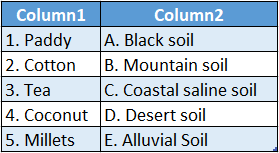
Answer: 1-C,2-A,3-E,4-B,5-D


WBBSE Solutions For Class 6 Geography Chapter 10 Our Country India Topic A General Introduction And Cultural Heritage Of India

WBBSE Chapter 10 Our Country India Topic A General Introduction And Cultural Heritage Of India Long Answer Type Questions

Question 1. Why is India called a land of diversity?
Answer:

India Is called a land of diversity:

India is called a land of great diversity for the following reasons:

Physiographic diversity: In terms of physical geography, India has the world’s highest mountain range running across its north and northeast flank, while in the southeast, south, and southwest, it is bounded by oceans.

In between, there are extended plains as well as vast plateau regions. Thus, different physical features can be clearly observed.

2. Climatic diversity: The state of Rajasthan in the west is dry and arid while the eastern and north-eastern states receive heavy rainfall. This also shows the great climatic diversity of the country.

3. Vegetational diversity: The great climatic diversity of the country results in a matching diversity in the natural vegetation of the country as well.

We can find evergreen equatorial forests on the western slopes of the Western Ghats and at the same time, we find practically no vegetation in the deserts of Rajasthan.

In the higher reaches of the hilly regions of the country, we find forests of conifers and in the plains, we find deciduous forests.

4. Soil diversity: A variety of soils is also found in India. Based on this, we find a range of agricultural practices, crops, and products.

5. Cultural diversity: India is home to people of many languages. They follow different religious values and they have different cultures which give rise to great cultural diversity as well.

Question 2. Discuss India’s geographic position. Or, Where exactly is our country located in the world?
Answer:

The geographic position of India is:

1. Latitudinal position: Indian mainland extends from 8°4′ N latitude to 37°6′ N latitude.

2. Longitudinal position: Indian mainland extends from 68°7′ E to 97°25′ E longitude.

3. Position with respect to hemispheres: In terms of latitude, India lies to the north of the Equator and so is in the northern hemisphere.

In terms of longitude, as India is to the east of the Prime Meridian, so it is in the eastern hemisphere.

4. Position with respect to the continent and surrounding waterbodies: India lies in the middle of the southern portion of the continent of Asia.

It lies to the north of the Indian Ocean, to the east of the Arabian Sea, and to the west of the Bay of Bengal.WBBSE Solutions For Class 6 Geography Chapter 10 Our Country India Topic A General Introduction And Cultural Heritage Of India Geographical location of india

Common Questions About India’s Diversity

Question 3. what is the significance of India being a peninsula?
Answer:

The significance of India being a peninsula is—

1. India is surrounded on three sides by water which makes trading via sea- routes easier.

2. Attacks by enemy nations are easier over land, so India is surrounded by water from three sides and has the locational advantage.

India’s extended coastline means extensive opportunities for fishing both for consumption and trade.

3. Monsoon winds gather adequate moisture as they pass over the surrounding waterbodies. This helps India to receive adequate rainfall which is very important for agriculture.

Question 4. List the top ten states in terms of area and their capitals.
Answer:

WBBSE Solutions For Class 6 Geography Chapter 10 Our Country India Topic A General Introduction And Cultural Heritage Of India State and capital

Question 5. Write a short note on the formation of states on the basis of language.
Answer:

The formation of states on the basis of language:

The States Re-organisation Act of 1956 was an Act that enabled the re-organization of the boundaries of the states along linguistic lines or language in independent India.

Earlier, the country was divided into provinces, princely states, and so on. With Independence and the accession of the princely states, the need arose for the re-organization of states.

The language was an obvious factor since the same language generally also implies a similarity of cultural heritage, customs, and most importantly, a sense of identity.

Although additional changes have been made to state boundaries after that, to date, this remains the most extensive exercise in shaping and forming states.

WBBSE Solutions For Class 6 Geography Chapter 10 Our Country India Topic A General Introduction And Cultural Heritage Of India Language and state UT

Question 6. Define union territories. The union territories of India with their capitals.
Answer:

The states of India which are directly under the administrative control of the Central Government are called union territories.

At present, there are eight union territories in India They are:

WBBSEWBBSE Solutions For Class 6 Geography Chapter 10 Our Country India Topic A General Introduction And Cultural Heritage Of India Language and state UT Solutions For Class 6 Geography Chapter 10 Our Country India Topic A General Introduction And Cultural Heritage Of India union territory and capital

Practice Questions on Indian Festivals and Traditions

Question 7. Write a short note on the capital of ” India—New Delhi.
Answer:

Capital of ” India—New Delhi:

New Delhi is the present capital of India. Till 1911, in pre-independent India, Kolkata was the capital of the British Empire before it was shifted to Delhi for administrative convenience.

In 1991, the 69 Constitutional Amendment designated New Delhi as a National Capital Territory, changing its status from that of a Union Territory. New Delhi has its own Chief Minister and Lieutenant Governor instead of a Governor.

WBBSE Solutions For Class 6 Geography Chapter 10 Our Country India Topic A General Introduction And Cultural Heritage Of India

WBBSE Chapter 10 Our Country India Topic A General Introduction And Cultural Heritage Of India Short Answer Type Questions

Question 1. Which water bodies Surround India on three Sides?
Answer:

The water bodies that surround India from three sides are the Arabian Sea to the west, the Indian Ocean to the south, and the Bay of Bengal to the East.

Question 2. Study India’s map and learn the name of India’s neighboring countries. Or, Which are our neighboring countries? Or, Which countries lie around India?
Answer:

To the northwest, India shares its borders with Pakistan and Afghanistan; in the north, with China, Nepal, and Bhutan; and to the east with Myanmar and Bangladesh. Sri Lanka lies to the south of India.

WBBSE Solutions For Class 6 Geography Chapter 10 Our Country India Topic A General Introduction And Cultural Heritage Of India Our neighbouring Coutries

Question 3. Which are the languages that enjoy the status of ‘official languages of India’?
Answer: The ‘official languages of India’ are:

  1. Assamese,
  2. Bengali,
  3. Gujarati,
  4. Hindi,
  5. Kannada,
  6. Kashmiri,
  7. Konkani,
  8. Malayalam,
  9. Manipuri,
  10. Marathi,
  11. Nepali,
  12. Oriya,
  13. Punjabi,
  14. Sanskrit,
  15. Sindhi,
  16. Tamil,
  17. Telugu,
  18. Urdu,
  19. Boro,
  20. Santhali,
  21. Maithili,
  22. Dogri.

Important Definitions Related to Indian Culture

Question 4. Through which of the states does the Tropic of Cancer pass?
Answer: The Tropic of Cancer passes through Gujarat, Rajasthan, Madhya Pradesh, Chattisgarh, Jharkhand, West Bengal, Tripura, and Mizoram.

WBBSE Solutions For Class 6 Geography Chapter 10 Our Country India Topic A General Introduction And Cultural Heritage Of India Tropic of cancer passing through different states

Question 5. Which states of India apart from West Bengal have a border with Bangladesh?
Answer: Assam, Meghalaya, Tripura, and Mizoram share borders with Bangladesh apart from West Bengal.

Question 6. Which states of India share borders with Nepal and Bhutan?
Answer: Uttarakhand, Uttar Pradesh, Bihar, West Bengal, and Sikkim are the states of India that share borders with Nepal.

On the other hand, Sikkim, West Bengal, Assam, and Arunachal Pradesh share borders with Bhutan.

WBBSE Solutions For Class 6 Geography Chapter 10 Our Country India Topic A General Introduction And Cultural Heritage Of India The states that share borders with nepal and bhutan

Question 7. Which states of India share borders with Myanmar?
Answer: Arunachal Pradesh, Nagaland, Manipur, and Mizoram are the Indian states that share borders with Myanmar.

WBBSE Solutions For Class 6 Geography Chapter 10 Our Country India Topic A General Introduction And Cultural Heritage Of India The states and the union territories that share borders with Myanamar

Examples of Cultural Practices in India

Question 8. Which states and union territories of India share borders with Pakistan?
Answer: Gujarat, Rajasthan, and Punjab are the states and Ladakh and Jammu and Kashmir (since 31 October 2019) are the union territories of India that share borders with Pakistan.

WBBSE Solutions For Class 6 Geography Chapter 10 Our Country India Topic A General Introduction And Cultural Heritage Of India The states and the union territories that share borders with pakistan

Question 9. Which states and union territories of India share borders with China?
Answer: Himachal Pradesh, Uttarakhand, Sikkim, and Arunachal Pradesh are the Indian states and Ladakh (since 31 October 2019) is the union territory that shares borders with China.

WBBSE Solutions For Class 6 Geography Chapter 10 Our Country India Topic A General Introduction And Cultural Heritage Of India the states that share borders with china

Question 10. Mention a few places in India that are because of their World Heritage Sites’ natural significance.
Answer: Some places in India are World Heritage sites because of their natural significance—

  1. Sunderban in West Bengal,
  2. Kaziranga in Assam,
  3. Nanda Devi in Uttarakhand.

Question 11. Mention a few places in India that are of great cultural and historical significance.
Answer: A few places that are of great cultural and historical significance in India are—

  1. Humayun’s Tomb in Delhi,
  2. Taj Mahal in Agra,
  3. Konark Sun Temple in Odisha,
  4. Khajuraho Temple in Madhya Pradesh,
  5. Ajanta and Ellora Caves in Maharashtra.

WBBSE Chapter 10 Our Country India Topic A General Introduction And Cultural Heritage Of India True Or False

Question 1. Latitudinally, in which hemisphere does India lie?
Answer: Northern Hemisphere.

Question 2. In which part of India is our state located?
Answer: Eastern part.

Question 3. Which is the westernmost longitude of the Indian landmass?
Answer: 68°7’E.

Question 4. Mention the longitudinal extension of India.
Answer: 68°7’E-97°25’E.

Question 5. Which state of India shares its borders with the maximum number of other states?
Answer: Uttar Pradesh (8 states).

Question 6. What is the length of India’s land boundary?
Answer: Almost 15200 km.

Question 7. What is the north-south length of the Indian landmass?
Answer: 3214 km.

Question 8. What is the east-west length of the Indian landmass?
Answer: 2933 km.

Real-Life Scenarios Involving Indian Heritage

Question 9. What is the total area of India?
Answer: 32,87,782 square km.

Question 10. Which is the southernmost tip of India?
Answer: Indira Point.

Question 11. How many languages enjoy official status in India?
Answer: 22 languages.

Question 12. Which country is the smallest of India’s neighbors?
Answer: Maldives.

Question 13. Which country is the largest of India’s neighbors?
Answer: China.

Question 14. What were the factors taken into consideration when the Indian states were formed?
Answer: Language, culture, and administrative capacity.

Question 15. What is the difference in local time between the extreme east and west of India owing to its longitudinal extent?
Answer: 117 minutes or nearly two hours.

Question 16. When did India become a republic?
Answer: January 26, 1950.

Question 17. Name the city in West Bengal through which the tropic of cancer passes.
Answer: Krishnanagar (Nadia).

WBBSE Chapter 10 Our Country India Topic A General Introduction And Cultural Heritage Of India Fill In The Blanks

Question 1. India is a part of the continent of___________
Answer: Asia

Question 2. A landmass bounded on three sides by water is called a___________
Answer: Peninsula

Question 3. India is divided into east and west by___________ longitude
Answer: 80ºE

Question 4. The state of Telangana was formed in the year___________
Answer: 2014

Question 5. There are ___________ union territories in India.
Answer: 8

Question 6. The capital of India is ___________
Answer: New Delhi

Question 7. The joint capital of the states of Andhra Pradesh and Telangana is ___________
Answer: Hyderabad

Question 8. The north-south extension of India is ___________ km.
Answer: 3214

Question 9. ___________is the largest city in India.
Answer: Mumbai

Question 10. The literacy rate in India is___________
Answer: 74.04%

Question 11. The least populated state in India is ___________
Answer: Sikkim

Question 12. The Sunderban mangroves are in the state of ___________
Answer: West Bengal

Question 13. The smallest state of India in terms of area is ___________
Answer: Goa

Question 14. In India, the official language of communication is ___________
Answer: English

Question 15. India’s neighboring country to the north is ___________
Answer: Nepal

WBBSE Chapter 10 Our Country India Topic A General Introduction And Cultural Heritage Of India Write True Or False

Question 1. India’s Independence Day is celebrated on 15 September.
Answer: False

Question 2. The southern part of India is shaped like a triangle.
Answer: True

Question 3. The Bay of Bengal is to the north of India.
Answer: False

Question 4. Indira Point is situated in the Arabian Sea.
Answer: False

Question 5. The Palk Strait divides India and Sri Lanka.
Answer: True

Question 6. India’s most populous city is Kolkata.
Answer: False

Question 7. Telangana is India’s newest state.
Answer: True

Question 8. India’s Standard Meridian is 82° 30′ E.
Answer: True

Conceptual Questions on India’s Historical Contributions

Question 9. Pakistan is India’s neighboring country in the East.
Answer: False

Question 10. Sri Lanka is located to the south of India.
Answer: True

Question 11. The Tropic of Capricorn is imagined to pass over India.
Answer: False

Question 12. India is located north of the Equator.
Answer: True

WBBSE Chapter 10 Our Country India Topic A General Introduction And Cultural Heritage Of India Match The Columns

Question 1.

WBBSE Solutions For Class 6 Geography Chapter 10 Our Country India Topic A General Introduction And Cultural Heritage Of India match the following 1.
Answer: 1-D,2-A,3-B,4-C,5-E

Question 2.

WBBSE Solutions For Class 6 Geography Chapter 10 Our Country India Topic A General Introduction And Cultural Heritage Of India match the following 2
Answer: 1-C,2-D,3-B,4-A,5-F,6-G,7-H,8-I,9-E

WBBSE Solutions For Class 10 Geography And Environment Chapter 7 Satellite Imageries And Topographical Maps

Chapter 7 Satellite Imageries And Topographical Maps Short Explanatory Answer Type Questions

Question 1. Write a shote note on the sensors of a satellite.
Answer:

The sensors of a satellite

An active sensor is a sensing device that provides its own energy source for illumination. It emits radiation directed towards the target and detects and measures radiation reflected from the target. Thus, active sensors help satellites to capture images at night.

A passive sensor is a sensing device that simply detects and responds to some type of input from the physical environment. In other words, a passive sensor can only be used to detect energy when emitted and reflected from the ground surface. Thus, passive sensors work when the sun is illuminating the earth.

Read and Learn Also WBBSE Solutions for Class 10 Geography and Environment

Question 2. What are the disadvantages of satellite images?
Answer:

The disadvantages of satellite images are—

  1. Data collection becomes difficult if the sky is cloudy.
  2. The exact height of any region or object cannot be calculated.
  3. The development of satellite images incurs high costs due to the use of highly advanced technology.

Topographic Map

WBBSE Solutions for Class 10 History WBBSE Solutions for Class 10 Geography and Environment
WBBSE Class 10 History Long Answer Questions WBBSE Solutions for Class 10 Life Science And Environment
WBBSE Class 10 History Short Answer Questions WBBSE Solutions for Class 10 Maths
WBBSE Class 10 History Very Short Answer Questions WBBSE Solutions for Class 10 Physical Science and Environment
WBBSE Class 10 History Multiple Choice Questions


Question 3. Write some characteristics of topographical maps.
Answer:

The characteristics of topographical maps are—

  1. Topographical maps represent the physical and cultural features of a region together. Hence, analysis of the region becomes easier.
  2. In the case of rivers, the direction of flow, nature of the river, and other details are provided. This helps to detect the direction of the slope of the land.
  3. The absolute height, relative height, or the type of terrain of the region can be clearly understood from a toposheet.
  4. Information about Economic activities practiced in the region can be easily analyzed

Question 4. What do you by ‘ an inch to a mile’ toposheet?
Answer:

Inch to a mile’ toposheet:

The 1° x 1° toposheet can be further subdivided into 16 toposheets (15′ %15’j. These are numbered from 1 to 16. These are known as ‘inch sheets or inch maps’. The scale of these maps is 1 cm to 0.5 km or 2 cm to 1 km.

Example— Topographical map no. 72 A/12.

WBBSE Class 10 Geography Chapter 7 Question Answer

Question 5. What is the various extra information that we get from the topographical maps apart from the ones regarding the physical and cultural features?
Answer:

The topographical maps provide us with several extra information—

  1. Map number of the region surveyed.
  2. The latitudinal and longitudinal extent of the region.
  3. State, district of the region surveyed.
  4. Year of the survey.
  5. Statement scale, R.F. as well as the linear scale of the map.
  6. Contour interval.
  7. List of conventional symbols used on the map.
  8. Names of the Surveyor General, the person conducting the survey and preparing the map.

Question 6. What are the different scales used in topographical maps? Or, Give an account of different types of scales in tabular form as used in “topographical maps”.
Answer:

The different scales used in topographical maps are—


Name of the sheet R.F. Statement Scale Latitudinal and longitudinal extent Map No. (Example)
Million Sheet 1:1,000,000 1 inch to 16 miles 4°x4° 73
Degree Sheet 1: 250,000 1 inch to 4 miles 1° x 1° 73 M
Half-degree sheet 1: 100,000 1 inch to 2 miles 30’x 30′ 73 M/NE
Inch Sheet 1: 50,000 1 inch to 1 mile 15′ x 15′ 73 M/5
Special maps 1: 25,000 4 cm to 10 km 5′ x 7’30” 73 M/5/2 (according to Old Layout before 1990) 73M/5/NE (according to New Layout since 1990)


“WBBSE Class 10 Geography Chapter 7 study guide”

Question 7. Give examples of topographical maps having an extension of 4° *4°, 1° x 1° and 15′ x 15′ toposheets.
Answer:

The examples are as follows—1. 4° x 4° topographical maps— 54, 55, 56, 57, etc.
2.1° x 1° topographical maps— 54B, 55P, 56D, 57A, etc. 3. 15′ x 15′ topographical maps— 54B/5, 55P/12, 56D/10, 57A/4, etc.

Question 8. What do you mean by the LANDSAT series satellites?
Answer:

LANDSAT series satellites

NASA took an initiative to develop and launch the first earth monitoring satellite to meet the needs of earth scientists. ERTS-A (Earth Resource Technology Satellites-A) was the first launched in a series of satellites in space to provide global coverage of the earth’s surface.

Later, the name of the series was changed to LANDSAT. The LANDSAT data is used for commercial, industrial, military, educational, etc, purposes both in the USA and the world over.

Question 9. Name some satellites launched by India.
Answer:

Some satellites launched by India are—

  1. Aryabhatta (India’s first satellite) —1975,
  2. Bhaskara-I —1979,
  3. Bhaskara-ll—1981,
  4. INSAT series (, 1B2E, 3A, 3C, 3D, etc.)—1983 onwards.

Question 10. Why are topographical maps important in the study of geography?
Answer:

Topographical maps are an important part of the study of geography. The knowledge of geography remains incomplete without the knowledge and study of topographical maps.

The significance of toposheets is as follows—

Topographical maps provide information regarding terrain, landform, rivers, lakes, forests, roadways, railways, bridges, temples, mosques, churches, settlements, and many other features of a region. This helps in analyzing and understanding the relationship between different physical and cultural features.

Topographical maps are also important to the military for understanding the various aspects required for protection. They are also useful in forming strategies for political Administration. Thus, maps of regions under military surveillance are restricted and not available to the public.

WBBSE Class 10 Geography Chapter 7 Question Answer

Question 11. What are the indicators of plain land on a topographical map?
Answer:

The indicators of plain land on a topographical map

The main indicator of relief of any region represented on a topographical map is the contours. If the contours lie quite far from each other, and their values are not too high, the region represented is a plain land. There are other indicators also.

Example—The rivers will be wide, perennial, and meandering. Sandbars and oxbow lakes may be present along the course of the river

WBBSE Solutions For Class 10 Geography And Environment Chapter 7

Question 12. How can a plateau be identified on a topographical map?
Answer:

If the contours on a topographical map run in a crooked manner and their values range from 400-600m, the region represents a plateau. Within this region, some concentric contours may represent domes or low hills. Rivers may also flow through the region.

Question 13. Discuss the characteristic features of geostationary satellites.
Answer:

The characteristic features of the geostationary satellites are as follows—

  1. They lie at a height of approximately 36,000 km above the earth’s surface.
  2. They revolve around the earth in 24 hours along the equatorial plane.
  3. They move from west to east like the earth.
  4. Being installed at such a height, they can take photographs of the full hemisphere at a time.
  5. They can take numerous photographs of the same region at a time. This makes data analysis very easy.

Question 14. Discuss the characteristic features of the sun-synchronous satellites.
Answer:

The characteristic features of the sun-synchronous satellites are—

  1. These satellites are installed at a height of 700-800 km above the earth’s surface.
  2. They move around the earth from the north pole to the south polar regions in circular or elliptical orbits.
  3. The satellites cover each area at a constant local time of the day.
  4. The images developed from the information collected by these satellites are used for detecting natural and mineral resources,
  5. surveying different regions, and preparing other kinds of maps with the acquired data like resource maps, forest maps, land use maps, etc. E.g.—The IRS series of satellites of India are sun-synchronous satellites.

WBBSE Class 10 Geography Chapter 7 Question Answer

Question 15. Discuss the use of colors to develop satellite images.
Answer:

Two types of colors are used in satellite images—

  1. True Colours
  2. False Colours

Use of true colors: If the satellite images represent the physical features of the earth in the exact colors as they appear in reality, they are said to be developed using true colors.

E.g.—Forests are represented in green, and rivers are represented in blue.

Use of false colors: If the satellite images represent the physical features of the earth with colors totally different from what they appear as in reality, they are said to be developed using false colors.

E.g.— The forests and natural vegetation are represented in red instead of green.

“Topographical maps Class 10 WBBSE notes”

Question 16. Discuss the various steps leading to the development of satellite images.
Answer:

The satellite images are developed following several steps.

At first, the sensors present in the satellites record the electromagnetic waves reflected by the target object or region. The passive sensors record the electromagnetic waves during day time.

At night; the active sensors record the waves with the help of the reflection of light from radars. These reflections are converted to digital information.

This information is then scanned and analyzed by the satellites and sent to the receiving centers on earth.

The area or region scanned by the satellites is divided into several grids and the information collected by them is inserted accordingly; in order to develop usable images.

These satellite images are analyzed by advanced computers and then used for their specific purposes.

Question 17. Why are false colors used In satellite images?
Answer:

Satellite images are developed by using two types of colors—i.e., true colors and false colors. True color images represent the physical features of the earth as they appear originally.

False color images represent the physical features with colors that are totally different from the original colors of the features. False colors help to represent the features with higher accuracy. They are also useful in maintaining the secrecy of certain information, as such images are not easily understood by a layman.

Question 18. How does the slope of the relief change, if the distance between contours in a topographical map increases or decreases?
Answer:

The contours are imaginary lines drawn in topographical maps joining places that have the same altitude. In a topographical map, if the contours lie very close to each other, it indicates that the slope of the land is steep. If the contours lie far apart from each other, it indicates that the slope of the land is gentle.

WBBSE Class 10 Geography Chapter 7 Question Answer

Question 19. What are the main characteristics of satellite imagery? Or, Briefly discuss three main characteristic features of satellite imageries.

1. Remote Sensing System: The sensors present in the satellites help in gathering information about a region or an object from very long distances, without coming in physical contact. This is called remote sensing.

2. Correct information: Satellite imageries provide absolutely correct information about the region being photographed.

3. Time of collecting information: The images are developed depending on the information collected by the sensors installed in the satellites. Passive sensors collect information during the daytime, while active sensors help to collect information at night.

4. Fast imaging: Satellite images can be developed very fast in the process of remote sensing. Also, the total manpower required in the whole process is less.

5. Survey of rugged terrain: Satellite images help to study inaccessible and rugged terrain, which would otherwise be difficult to physically survey.

6. Weather forecast: The series of images of the atmosphere available continuously, help in understanding the current weather phenomena. This helps in analyzing and forecasting weather.

Question 20. What are the uses of satellite images?
Answer:

Satellite images are used for various purposes.

A few of them listed are as follows—

  1. Knowledge about the land surface, land use, and land cover:
  2. The types of land surfaces can be identified and classified.
  3. Land use and land cover maps can be prepared.
  4. Changes in land use patterns can be identified from images over time

Question 21. What are the differences between topographical maps and satellite images?
Answer:

The difference between satellite images and topographical maps are followed-

WBBSE Class 10 Geography Chapter 7 Question Answer

Point of difference  Topographical maps  Satellite images 
Concept  They are maps representing the physical.

They are images that are developed

They are images and cultural features of a region

based on remote sensing through field surveys of the region satellites.

Colors/Symbols used The physical and cultural features are represented by conventional symbols and specific colors. The physical and cultural features are photographed and represented by true or false colors.
Time of data collection Generally, surveys are conducted during the day. Data can be collected at any time of the day or night.
Scale The scale of features represented on topographical maps is not always accurate.

E.g.—Rivers and roadways are difficult to be represented | accurately.

The satellites use highly advanced sensors.

Hence the scale of the images developed is accurate.

Analysis of images Analysis of topographical maps is comparatively easier. It can be easily interpreted.
if one has knowledge of conventional symbols.
The features represented in satellite images are difficult to be analyzed. Hence experts are required.
Publisher In India, topographical maps are published by the Survey of India, Dehradun. In India, satellite images are published by the National Remote Sensing Centre, Hyderabad.

Chapter 7 Satellite Imageries And Topographical Maps Short Answer Type Questions

WBBSE Solutions For Class 10 Geography And Environment Chapter 7

Question 1. What are the uses of satellite images?
Answer:

The uses of satellite images

Satellite images are photographs of the earth and other planets captured by imaging satellites installed in space.

Question 2. What are artificial satellites?
Answer:

Artificial satellites

Artificial satellites are highly advanced objects orbiting the earth and other planets in space transmitting signals which are turned into relevant information by man. They are used for various purposes, like military operations, weather forecasting, mapping various regions, gathering information about different aspects of the earth, etc.

Question 3. What is remote sensing?
Answer:

Remote sensing

Remote sensing is the method of gathering information about any region or object on the earth’s surface or the surface of other planets from a considerable distance, without coming in physical contact. This information helps in analyzing the region or the object.

“Satellite imagery in geography Class 10”

Question 4. What do you mean by electromagnetic radiation?
Answer:

Electromagnetic radiation

Electromagnetic radiation refers to waves of the electromagnetic field carrying electromagnetic radiant energy propagating through space. It includes visible light, radio waves, gamma rays and X-rays, ultraviolet rays, etc. These waves do not need any solid or liquid medium for propagation.

Class 10 Geography West Bengal Board

Question 5. What do you mean by ‘nadir’?
Answer:

‘Nadir’:

‘Nadir7 is the point on the earth’s surface vertically beneath the satellite. It lies diametrically opposite to the zenith.

WBBSE Solutions Class 10 geography and environment chapter 7 Satellite imageries and topgraphical maps nadir and zenith


Question 6. Mention two importance of satellite imagery.
Answer:

Two important satellite images are—

  1. Satellite images help in detecting physical features, and natural and man-made resources of an area.
  2. Satellite images help in weather forecasting.

Question 7. What do you mean by the IRS series of satellites?
Answer:

IRS series of satellites

IRS refers to ‘Indian Remote Sensing’. This organization manufactures and launches satellites into space under the name IRS series for the purpose of remote sensing. The first such satellite was launched by India in 1988.

Question 8. What are geostationary satellites?
Answer:

Geostationary satellites

The artificial satellites that orbit the earth from west to east in circular orbits at the same time as that of the earth’s one rotation (24 hours), are called geostationary satellites. They are found at a height of approximately 36,000 km above the equator. Eg.—GOES- E, GOES-W

Class 10 Geography West Bengal Board

Question 9. What are sun-synchronous satellites?
Answer:

Sun-synchronous satellites

The sun-synchronous satellites are those which are installed on a geocentric orbit that combines altitude and inclination in such a way, that the satellite passes over any given point of the planet’s surface at the same local solar time.

These satellites are installed 700-800 km above the land surface and orbit the earth in circular or elliptical paths from the north pole to the south polar regions. These are mainly used for the detection of mineral resources on the earth. Example-IRS, LANDSAT, etc.


WBBSE Solutions Class 10 geography and environment chapter 7 Satellite imageries and topgraphical maps geo-stationary and sun-synchronous satellities


Question 10. How can the best quality satellite images be obtained?
Answer:

The best quality satellite images can be obtained during day time when the sky is clear and there is sufficient sunlight.

Question 11. What are topographical maps?
Answer:

Topographical maps

The maps that represent the physical and cultural features of a region together on the same map drawn to a scale with the help of conventional symbols, are called topographical maps.

Question 12. Who prepares the topographical maps in India?
Answer:

The topographical maps are prepared in India by the ‘Survey of India’. This organization was established in 1767. Its headquarters is situated at Dehradun, Uttarakhand.

Question 13. What are contour lines?
Answer:

Contour lines

The imaginary lines drawn on topographical maps joining places having the same altitude above mean sea level, are called contour lines. They are represented as brown lines on topographical maps.

Class 10 Geography West Bengal Board

Question 14. In how many ways can the altitude of any place be represented?
Answer:

The altitude of any place can be represented in three ways—

  1. Height above the mean sea level,
  2. Absolute altitude,
  3. Relative relief.

Question 15. What do you mean by relative relief?
Answer:

Relative relief:

The difference in height or altitude of a place and the altitude of the highest point of that region is known as relative relief.

Question 16. What do you understand when the R.F. of a map is 1:50,000?
Answer:

R.F. of a map is 1:50,000

R.F. (Representative Fraction) 1:50,000 means that 1 cm on the map represents 50,000 cm or 0.5 km distance on the ground.

Question 17. What does the green color used on toposheets indicate?
Answer:

The flat green color used on the toposheets indicates forest cover. Also, some symbols drawn with green represent different kinds of natural vegetation.


WBBSE Solutions Class 10 geography and environment chapter 7 Satellite imageries and topgraphical maps use of green colour on toposheets


Question 18. What are degree sheet topographical maps?
Answer:

Degree sheet topographical maps

The topographical maps are constructed on a scale of 1 inch to 4 miles, or have an R. F.
1:250,000 are called degree sheet topographical maps. They have a latitudinal and longitudinal extent of 1° x 1°.

Question 19. What are inch-sheet topographical maps?
Answer:

Inch-sheet topographical maps

The topographical maps that are constructed on a scale of 1 inch to 1 mile or have an R.F. 1:50,000, are called inch sheet topographical maps. The latitudinal and longitudinal extent of such maps is 15’x 15′.

Class 10 Geography West Bengal Board

Question 20. How are conical hills represented on topographical maps?
Answer:

If the contour lines of a region lie in concentric circles and the distance between adjacent contours is more or less uniform, the feature represented is a conical hill.


WBBSE Solutions Class 10 geography and environment chapter 7 Satellite imageries and topgraphical maps conical hill


Question 21. How can ‘badland’ be identified on a topographical map?
Answer:

Badland is represented on a topographical map by broken black lines along the nonperennial rivers in dry or arid regions. The badlands are formed mostly due to gully erosion in dry or arid regions due to a lack of vegetation, and rough soil.

Question 22. What is spot height?
Answer:

Spot height:

The exact height of any place above mean sea level(MSL) represented by a dot and the height mentioned in figures beside it on a toposheet, is known as spot height. The figures mentioned in the spot heights may be written in ‘feet’ or ‘meters’, depending on the type of scale of the map.

Class 10 Geography West Bengal Board

Question 23. What do you mean by the platform of a satellite?
Answer:

Platform of a satellite:

The place where the artificial satellite is installed in space to move in its own circular or elliptical orbit is called the platform of the satellite.

Question 24. What is an active sensor?
Answer:

Active sensor

An active sensor is a sensing device that provides its own energy source for illumination. lt emits radiation directed towards the target and detects and measures radiation reflected from the target. Thus, active sensors help satellites to capture images at night.

Question 25. What is a passive sensor?
Answer:

Passive sensor

A passive sensor is a sensing device that simply detects and responds to some type of input from the physical environment. In other words, a passive sensor can only be used to detect energy when emitted and reflected from the ground surface. Thus, passive sensors work when the sun is illuminating the earth.

WBBSE Solutions For Class 10 Geography And Environment Chapter 7

Question 26. What do you mean by FCC?
Answer:

FCC:

FCC means ‘False Colour Composite’. In the case of satellite images, a different set of color schemes other than their original color is used to portray the physical features (rivers, vegetation, forests, relief, etc.) and the artificial features (roads, settlements, etc.) of the earth’s surface. The color scheme used has an international standardization. E.g. vegetation is shown in red color.

“Understanding topographical maps Class 10 WBBSE”

Question 27. What do you mean by escape velocity?
Answer:

Escape velocity:

The escape velocity is the minimum velocity required by an object to escape the gravitational attraction of a planet or any other body. The unit for escape velocity is meters per second (m/s). The escape velocity of the earth is 11.2km/s.

Class 10 Geography West Bengal Board

Question 28. Define topographical Map.
Answer:

Topographical Map:

The maps that represent the physical and cultural features of a region together on the same map drawn to a scale with the help of conventional symbols, are called topographical maps. This type of map is prepared on the basis of primary data obtained by surveying a particular area. The topographical maps are prepared in India by the ‘Survey of India’. This organization was established in 1767. Its headquarters is situated at Dehradun, Uttarakhand.

Class 10 Geography Chapter 7 Question Answer WBBSE

Chapter 7 Satellite Imageries And Topographical Maps Multiple Choice Type Questions Mcq type


Write The Correct Answer From The Given Alternatives

Question 1. The word ‘Satellite’ means- in French—

  1. Celestial body moving around planets
  2. Guard
  3. Observation
  4. Gatekeeper

Answer: 2. Guard

Question 2. Which one is a natural satellite?

  1. Pluto
  2. Earth
  3. Jupiter
  4. Moon

Answer: 4. Moon

Question 3. The first artificial satellite of the Earth was—

  1. INSAT-1
  2. Landsat-1
  3. Sputnik 1
  4. Aryabhatta

Answer: 3. Sputnik 1

Question 4. The first artificial satellite launched by India was—

  1. INSAT-1
  2. Landsat-1
  3. Sputnik 1
  4. Aryabhatta

Answer: 4. Aryabhatta

Question 5. The first astronaut from India, who visited space was—

  1. Yuri Gagarin
  2. Valentina Tereskova
  3. Rakesh Sharma
  4. Sunita Williams

Answer: 3. RakeshSharma

Class 10 Geography Chapter 7 Question Answer WBBSE

Question 6. The first satellite images of the earth were developed in the year—

  1. 1959
  2. 1965
  3. 1970
  4. 1947

Answer: 1. 1959

Question 7. The first artificial satellite launched by NASA was—

  1. IRA-IA
  2. LISS-II
  3. NOAA
  4. TIROS-1

Answer: 4. TIROS-1

Question 8. The geostationary satellites are installed km above the land surface—

  1. 600 km
  2. 6000 km
  3. 12,000 km
  4. 36,000 km

Answer: 4. 36,000 km

Question 9. The place where an artificial satellite is installed in space is called the—

  1. Spot
  2. Sensor
  3. Platform
  4. Lansmat

Answer: 3. Platform

Question 10. is a geostationary satellite launched by India—

  1. METEOSAT
  2. GOMS
  3. INSAT
  4. GMS

Answer: 3. INSAT

Class 10 Geography Chapter 7 Question Answer WBBSE

Question 11. The sun-synchronous satellites are installed at a height of km from the earth’s surface—

  1. 500-700 km
  2. 600-800 km
  3. Above 40,000 km
  4. Above 36,000 km

Answer: 2. 600-800 km

Question 12. The sun-synchronous satellites move from—

  1. East to West
  2. West to East
  3. North to South
  4. South to North

Answer: 3. North to South

Question 13. In a satellite image, the vegetation appears to be—

  1. Red
  2. Blue
  3. Green
  4. Yellow

Answer: 1. Red

Question 14. The topographical maps are constructed based on the—

  1. Mathematical calculations
  2. Survey
  3. Photographs
  4. None of these

Answer: 2. Survey

Question 15. The Survey of India was established in—

  1. 1567 A.D.
  2. 1767 A.D.
  3. 1667 A.D.
  4. 1867 A.D.

Answer: 2. 1767 A.D.

Class 10 Geography Chapter 7 Question Answer WBBSE

Question 16. The SPOT-1 satellite was launched in the year—

  1. 1978
  2. 1986
  3. 1990
  4. 1996

Answer: 2. 1986

Question 17. The main work of the SPOT satellite is—

  1. To help in international trade
  2. To forecast weather
  3. To help in agriculture
  4. To help in industrial development

Answer: 1. To help in international trade

Question 18. The internationally accepted scale for topographical maps is—

  1. 1:1,000,000
  2. 1:200,000
  3. 1:100,000
  4. 1:50,000

Answer: 1. 1:1,000,000

Question 19. The topographical maps covering the South Asian region are drawn on a scale of—

  1. 1:1,000,000
  2. 1:200,000
  3. 1:100,000
  4. 1:10,000

Answer: 2. 1:200,000

Question 20. The topographical maps covering India and its neighboring countries are drawn on a scale of—

  1. 1:1,000,000
  2. 1:200,000
  3. 1:100,000
  4. 1:50,000

Answer: 1.1:1,000,000

Question 21. The LANDSAT-1 satellite collects data of India—

  1. Forests
  2. Soil erosion
  3. Military routes
  4. Radars of enemy countries

Answer: 4. Radars of enemy countries

Question 22. The topographical maps with an R.F. of 1:50,000 cover a latitudinal and longitudinal extent of—

  1. 4°x4°
  2. 1° x 1°
  3. 30’x 30′
  4. 15’x 15′

Answer: 4. 15’x 15′

Class 10 Geography Chapter 7 Question Answer WBBSE

Question 23. The metric scale in ‘million sheets’ topographical maps is—

  1. 1 cm to 10 km
  2. 1 cm to 2.5 km
  3. 1 cm to 1 km
  4. 1 cm to 500 km

Answer: 1. 1 cm to 10 km

Question 24. The geostationary satellite launched by Japan is—

  1. INSAT
  2. NOAA
  3. GMS
  4. LANDSAT

Answer: 3. GMS

Question 25. The infrared rays are used for acquiring—

  1. Aerial photographs
  2. Topographical maps
  3. Satellite imageries
  4. Different scalesAnswer: 3. Satellite imageries

Question 26. maps show physical and cultural features on the same map—

  1. Mouza
  2. Topographical
  3. Weather
  4. Political

Answer: 2. Topographical

Question 27. The different features on the topographical maps are represented with the help of—

  1. Graphs
  2. Different colors
  3. Conventional symbols
  4. Scale

Answer: 3. Conventional symbols

Question 28. On topographical maps, height is represented with the help of—

  1. Contour lines
  2. Isobars
  3. Isohytes
  4. Isotherms

Answer: 1. Contour lines

Class 10 Geography Chapter 7 Question Answer WBBSE

Question 29. Satellite imagery is—

  1. Photograph of the satellite
  2. Photograph of the earth’s surface
  3. Photograph of the space
  4. Imagery developed with the help of information collected by the satellite

Answer: 4. Imagery developed with the help of information collected by the satellite

Question 30. The sensor used in developing satellite imagery is—

  1. MISS
  2. USS
  3. D1SS
  4. TISS

Answer: USS

Question 31. The electromagnetic energy used by sensors which are then processed and developed into a satellite image comes from the—

  1. Moon
  2. Earth
  3. Sun
  4. None of these

Answer: 3. Sun

Question 32. The topographical maps are prepared in India by the—

  1. Geological Survey of India (GSI)
  2. Survey of India (SOI)
  3. Anthropological Survey of India (ASI)
  4. General Sample Survey (GSS)

Answer: 2. Survey of India (SOI)

Question 33. The satellite sent by India is –

  1. IRS
  2. LANDSAT
  3. SPOT
  4. Station

Answer: 1. IRS

Chapter 7 Satellite Imageries And Topographical Maps If the statement is true, write True, and if false write false against the following


Question 1. Sensors are very important in remote sensing.
Answer: True

Question 2. Photographs taken by artificial satellites are called satellite images.
Answer: True

Question 3. The geostationary satellites move from the west to the east in the same direction as the earth’s rotation.
Answer: True

Question 4. The ultraviolet rays of the electromagnetic spectrum are used in remote sensing.
Answer: False

Question 5. Radio waves are the longest waves of the electromagnetic spectrum.
Answer: True

Question 6. Topographical maps are more accurate than satellite imagery.
Answer: False

Question 7. A map with R.F. 1:25,000 can be constructed to represent an area of 89 sq. km.
Answer: True

Class 10 Geography Chapter 7 Question Answer WBBSE

Question 8. The satellite images in India are developed by the National Remote Sensing Centre, Hyderabad.
Answer: True

Question 9. The LANDSAT satellite gives information on the density of the ozone layer.
Answer: False

Question 10. Radars are used to take photographs only at night.
Answer: False

Question 11. Near-infrared rays are used to sense areas of natural vegetation.
Answer: True

Question 12. Generally, satellites capture and transmit signals after every 10 days.
Answer: False

Question 13. 52 y is a topographical map of the plateau region of India.
Answer: False

Question 14. Contour lines in topographical maps are drawn in brown color.
Answer: True

Question 15. 1:25,000 is a small-scale map.
Answer: False

Question 16. The larger the scale, the smaller the area of the region represented on the map.
Answer: True

Question 17. The contours in topographical maps never intersect each other.
Answer: True

Question 18. Radar is a sensor.
Answer: True

Question 19. Satellite imagery is the best method of remote sensing.
Answer: True

Question 20. ‘Platform’ is the place in space where the satellites are installed.
Answer: True

Chapter 7 Satellite Imageries And Topographical Maps Fill In The Blanks With Suitable Words

Question 1. INSAT-l is an _______
Answer: Artificial satellite

Question 2. Advanced_______ cameras are used in clicking satellite images.
Answer: High resolution

Question 3. Information acquired about an object from _______ a great distance without actually coming in contact with the object is called _______
Answer: Remote sensing

Question 4. The geostationary satellites of India are of _______ the series.
Answer: INSAT

Question 5. The total number of topographical maps drawn in the international series for both the northern and southern hemispheres of the earth is _______
Answer: 2222

Question 6. The three types of scales used in the construction of maps are statement scale, R.F and _______
Answer: Linear scale

Question 7. A _______ helps to collect secretive information such as photographs of missiles, military movements of enemies, etc.
Answer: Spy camera

Question 8. The reflected electromagnetic waves are received by the ______ of satellites.
Answer: Sensors

Question 9. The smallest unit of an image is called a_______
Answer: Pixel

Class 10 Geography Chapter 7 Question Answer WBBSE

Question 10. The OCEANSAT satellite capture images after every _______ hour.
Answer: 48 hours

Question 11. The LANDSAT satellite captured images of the same region after every _______ day.
Answer: 18 days

Question 12. The father of remote sensing in India is _______
Answer: P. R. Pisharoty

Question 13. The unit used to measure the length of waves in a spectrum is_______
Answer: Micrometer

Question 14. The_______ and _______rays are not used in remote sensing.
Answer: Gamma, X

Question 15. The_______ rays are used in remote sensing.
Answer: Infrared

Question 16. The ultraviolet rays are absorbed by the _______layer of the atmosphere, hence, they are not used in remote sensing.
Answer: Ozone 17.1988

Question 17. The IRS satellites were first launched in India in _______
Answer: 1988

Question 18. The use of _______ is maximum in remote sensing.
Answer: Artificial satellites

Question 19. The Indian Space Research Organisation is situated in_______
Answer: Bengaluru

Question 20. The topographical maps are a type of _______ maps.
Answer: Large-scale one

Chapter 7 Satellite Imageries And Topographical Maps Answer in one or two words

Question 1. What are the basic steps of remote sensing?
Answer: Collection of data, image analysis, and interpretation.

Question 2. What are the two methods of remote sensing?
Answer: Aerial photography and satellite imagery.

Question 3. When was the term ‘remote sensing’ first used?
Answer: 1960.

Question 4. Name the source of energy used in capturing satellite images.
Answer: Sun.

Question 5. What is the R.F. of topographical maps of the international series?
Answer: 1:1,000,000.

Question 6. How many grids of topographical maps are there in India?
Answer: 135.

Question 7. What is the scale of million sheets of Indian topographical maps?
Answer: 1:1,000,000.

Question 8. What is the scale of the degree sheets of Indian topographical maps?
Answer:1:250,000.

Question 9. What are the topographic maps with a scale of 1:100,000 called?
Answer: Quadrant sheets.

Question 10. Where is the headquarters of the Survey of India located?
Answer: Dehradun.

Class 10 Geography Chapter 7 Question Answer WBBSE

Question 11. Where is the branch of Survey of India located in West Bengal?
Answer: Kolkata.

Question 12. What is the contour interval in topographical maps?
Answer: 20 thin m (although some maps may have a contour interval of 10m).

Question 13. What is the scale of inch sheets of Indian topographical maps?
Answer: 1:50,000.

Question 14. What are the latitudinal and longitudinal topographical maps?
Answer: the extent of million sheets of Indian

Question 15. What is the latitudinal and longitudinal extent of degree sheets of Indian topographical maps?
Answer: l°xl°.

Question 16. What is the metric scale of degree sheets of topographical maps?
Answer:1cm to 2.5 km.

Question 17.What kind of topographical map is map no. 73A?
Answer: Degree sheet.

Question 18. What is the escape velocity needed to launch a satellite in space?
Answer: About 11.2 km/second.

Question 19. What is the escape velocity on the surface of the moon?
Answer: About 2.31 km/second.

Question 20. What is the escape velocity on the surface of the sun?
Answer: 617.6 km/second.

Question 21. What are satellites that orbit the earth from west to east and are stationed directly over the equator called?
Answer: Geo-stationary satellites.

Question 22. What is a temporary orbit used during the launch of a satellite called?
Answer: Parking orbit.

Question 23. Which satellites are deployed for military applications?
Answer: Reconnaissance satellites.

Question 24. Name one of the largest domestic communication satellite systems in India?
Answer: INSAT system.

Question 25. What is the LANDS AT series presently known as?
Answer: NOAA.

Question 26. When was the SPOT-1 satellite launched?
Answer: 1986.

Class 10 Geography Chapter 7 Question Answer WBBSE

Question 27. From where was the SPOT-1 launched?
Answer: French Guiana.

Question 28. What makes the sky appear blue?
Answer: Rayleigh scattering.

Question 29. Mention an important use of a satellite image.
Answer: The weather forecast.

Question 30. Mention a disadvantage of satellite images.
Answer: Cannot be understood by a layman.

Question 31. What are topographical maps also known as?
Answer: Toposheets.

Question 32. What are 1° x 1° toposheets called?
Answer: Degree sheets.

Question 33. Where is the scale of the map mentioned in a toposheet?
Answer: South of the map.

Question 34. What does the red color in a toposheet indicate?
Answer: Settlements and roads.

Question 35. How is natural vegetation represented on a toposheet?
Answer: In green color.

Question 36. What does NH indicate on a toposheet?
Answer: National Highway.

Question 37. What do PS and DB indicate on a toposheet?
Answer: Police station, Dak Bungalow.

Question 38. In which type of map, relief is shown by contour lines?
Answer: Topographical maps.


Chapter 7 Satellite Imageries And Topographical Maps Match The Following With The Right Column

1.

Left Column Right Column
1.  Wavelength of gamma rays A. 10_8m to 10’11m
2. Wavelength of infrared rays B.  7x 10_7m to 4 x 10 7m
3. Wavelength of ultraviolet rays C.  10-3m to 7 x 10_7m
4. Wavelength of visible light D. 10_11m
5. Wavelength of infrared rays E. 4 x 10″7 to 6 x 10_8m

Answer: 1-D,2-A,3-E,4-B,5-C

2.

Left Column Right Column
1. Red double line on topographical maps A. Hyderabad
2. GOES B. Sensors
3. Remote Sensing Centre C. Non-perennial rivers
4.LISS, PAN, OCM, etc. D. Metalied road
5. Black lines on topographical maps E. Artificial satellite

Answer: 1-D,2-E,3-A,4-B,5-C

WBBSE Solutions for Class 10 Geography and Environment

WBBSE Solutions For Class 6 Geography Chapter 8 Air Pollution Topic B Effects And Control Of Air Pollution

WBBSE Class 6 Geography  Chapter 8 Air Pollution Topic B Effects And Controls Of Air Pollution Long Answer Type Questions

Question 1. Discuss the measures for controlling air pollution.
Answer:

The different measures for controlling air pollution are as follows—

  1. We must place a handkerchief to cover our mouth while sneezing or coughing.
  2. The room, where gas or stoves are lit, must be well-ventilated for the smoke emitted while cooking to escape.
  3. The dustbins in our rooms should always be covered.
  4. Rooms must be kept open and ventilated for air to pass freely while painting windows and doors.
  5. Mosquito nets instead of mosquito coils should be used to avoid injury to health.
  6. One should not be allowed to smoke in a confined room as the smoke emitted mixes with air and causes harm to the health of others present in the room.

Read And Learn More WBBSE Solutions For Class 6 Geography

Question 2. What are the effects of air pollution?
Answer:

There are various effects of air pollution on the environment.

These are as follows—

Effects on human beings: Air pollution can cause respiratory problems, asthma, heart disease, lung cancer and cough.

Effects on plants: Air pollution may cause discolouration of leaves and death of plant tissues. It also causes the death of immature plants and reduces the production of fruits and flowers.

Acid rain: When water droplets and oxygen combine with harmful gases such as sulfur dioxide, nitrogen oxides, carbon dioxide, and carbon monoxide, acid rain is formed which destroys plants, aquatic organisms and marble sculptures.

Smog: Smog is the combination of smoke and fog. It is detrimental to living organisms and may even cause death.

WBBSE Class 6 Effects of Air Pollution Notes

WBBSE Solutions For Class 6 Geography WBBSE Solutions For Class 6 History WBBSE Solutions For Class 6 Maths
WBBSE Class 6 Geography Notes WBBSE Class 6 History Notes
WBBSE Class 6 Geography Multiple Choice Questions WBBSE Class 6 History MCQs WBBSE Notes For Class 6 School Science


Increase in the atmospheric temperature: Atmospheric temperature increases due to an increase in the number of harmful gases like carbon dioxide, sulfur oxide, and nitrogen oxide in the atmosphere.

Depletion of the ozone layer: Chlorofluorocarbon (CFC) emitted from air conditioners, and refrigerators are responsible for the destruction of the ozone layer.

Due to the formation of the ozone hole, the earth’s surface receives harmful ultraviolet radiation from the Sun.

WBBSE Solutions For Class 6 Geography Chapter 8 Air Pollution Topic B Effects And Control Of Air Pollution

Question 3. Write down the harmful effects of acid rain.
Answer:

Acid rain or rainfall with a high acidic content is itself a result of air pollution.

The harmful effects of acid rain are as follows—

  1. The acidity of ponds, lakes and rivers increases. This causes harm to the aquatic flora and fauna.
  2. The acid balance of the soil gets disturbed and the fertility decreases.
  3. Damage is caused to the skin of human beings and animals.
  4. Marble and limestone structures and monuments develop small pores and holes, leading to their eventual decay.
  5. Acid rain damages bridges’ steel and causes discolouration of paints applied on houses.
  6. Germination of seeds gets disrupted due to acid rain.

WBBSE Solutions For Class 6 Geography Chapter 8 Air Pollution Topic B Effects And Control Of Air Pollution Acid rainQuestion 4. Discuss the effects of global warming.
Answer:

The effects of global warming:

The earth is getting warmer like a greenhouse due to the increase in the number of greenhouse gases in the atmosphere. This phenomenon is known as global warming.

The ill effects of global warming are discussed below—

Change in climate: Different parts of the world are experiencing a change in climate due to global warming.

Rise in temperature: The average temperature of seas and oceans has risen due to global warming.

Melting of glaciers: Due to the increase in temperature, polar ice caps and mountain glaciers are gradually melting which ultimately leads to the rise in sea level.

Important Definitions Related to Air Pollution Control

Extinction of plants and animals: Certain species of plants and animals have become extinct due to global warming.

Question 5. What can we do to reduce pollution?
Answer:

The different measures which can be adopted to control air pollution are discussed below—

Use of public transport: The intensity of air pollution would be reduced if we travel by public transport like buses or trains instead of personal or private cars.

Use of non-polluting vehicles: If more nonpolluting vehicles such as electric trains, trams, metros, and bicycles are used then air pollution can be effectively controlled.

Using cars with less polluting engines: Cars with very old engines should not be used as they cause a lot of pollution. So, nowadays less polluting engines manufactured by advanced technology are used.

Locating industrial plants away from residential areas: The factories and industrial plants should be located far away from residential areas.

Also, the waste materials released from these industrial units need to be treated before discharge.

Using non-conventional sources of energy: Different non-conventional sources of energy like solar energy, wind energy and tidal energy should be utilised instead of conventional energies like coal and petroleum.

Afforestation: Plants play an important role in maintaining the oxygen-carbon dioxide balance in the environment.

They also help in minimising air pollution because the movement of dust particles and carbon particles floating in the air is restricted by the leaves. So it is important to plant trees along the roads and around industrial plants.

Question 6. How does air pollution affect the ozone layer?
Answer:

Air pollution affect the ozone layer:

The ozone layer of the atmosphere works as a sunscreen for the Earth.

It protects the earth from the harmful effects of ultraviolet (UV) radiation coming from the sun as the UV rays cannot penetrate through the ozone layer.

However, the ozone layer has been gradually depleting due to air pollution.

Chlorofluorocarbon (CFC) emitted from air conditioners, refrigerators and nitrogen oxide emitted from supersonic jets, nuclear explosions, etc. are responsible for the depletion of the ozone layer.

Question 7. What are the effects of ozone layer depletion on the environment?
Answer:

The effects of ozone layer depletion on the environment:

Ozone gas is poisonous but it forms a layer in the stratosphere which protects the earth from the harmful effects of the ultraviolet radiation of the Sun.

There are various effects of ozone layer depletion—

Effect on human beings: Depletion of the ozone layer can cause skin cancer, reduce immunity, and cause skin burns.

It may also lead to dizziness, sleepiness, breathlessness and even long-term diseases like bronchitis, asthma and other cardiac problems.

Effect on animals: Thinning of the ozone layer reduces the immunity in animals, and has harmful effects on small fishes, crabs and other zooplankton.

Effect on plants: Ozone layer depletion also affects the plant kingdom. It disrupts photosynthesis in plants, reduces the production of fruits and flowers and causes the destruction of phytoplankton’s.

Short Questions on Air Pollution Effects

It damages certain plant parts and leads to loss of color and scarring in leaves. It may even lead to premature ageing.

Question 8. Write a short note on acid rain.
Answer:

Acid rain:

Different types of poisonous gases (such as carbon dioxide, nitrogen oxides, and sulphur dioxide) react with rainwater to produce acid which falls on the earth’s surface as acid rain.

Carbon dioxide, carbon monoxide, nitrogen oxides, and sulphur dioxide emitted from vehicles and factories react with oxygen and moisture in the air to produce acid.

This acid combines with rainwater and falls on the ground as acid rain. Acid rain adversely affects the soil and trees and is fatal for fish and aquatic organisms.

Statues and monuments made of marble are also damaged by acid rain.

Question 9. State the main greenhouse gases and list their sources.
Answer:

The main greenhouse gases and list their sources:

The main greenhouse gases are carbon dioxide, methane, nitrous oxide and water vapour

The different sources of the main greenhouse gases are listed below—

  1. Burning of fossil fuel (coal, petrol).
  2. Wastes from factories, power plants and atomic power plants.
  3. Decomposition and burning of organic matter.
  4. Use of chemical fertilisers and pesticides in farming.
  5. Wastes from households and municipalities.

Question 10. Briefly write about global warming.
Answer:

Global warming:

Heat from the sun easily reaches the earth’s surface during the daytime.

However, the presence of various greenhouse gases in the air absorbs some of this heat and prevents it from escaping back to space.

As a result, the average temperature of the earth rises. This phenomenon is known as global warming.

Question 11. What is a greenhouse? What is meant by the greenhouse effect?
Answer:

Greenhouse:

In cold countries, plants are grown in a glass house. The glass walls allow the sunlight to enter but do not allow it to return.

This special type of glass house is called a greenhouse. The inner environment of a greenhouse remains warm.

The thermal radiation from the sun is absorbed by water vapour, carbon dioxide, methane, nitrous oxide and other greenhouse gases present in the earth’s atmosphere.

As a result, the temperature on Earth increases day by day due to the absorption of thermal radiation.

This phenomenon by which the temperature of the earth’s surface is increasing is known as the greenhouse effect.

Question 12. What can we do to control air pollution?
Answer:

We can adopt various ways to control air pollution.

These are as follows—

Use of public transport: We can use public transport instead of private cars and motor vehicles. This will reduce air pollution.

Use of pollution-free vehicles: Air pollution can be reduced by using electric trains, trams, bicycles, and cycle rickshaws. At present, battery-powered motorcycles, and motor vehicles are also in use.

Other measures: Industries should be built far away from residential areas; air pollution can be reduced by using non-conventional energies instead of conventional energies, and by planting more trees.

Common Questions About Health Impacts of Air Pollution

Question 13. What are the ways to reduce pollution at home?
Answer:

Some of the ways to reduce pollution at home are given below—

  1. Kitchens should be well-ventilated.
  2. Dustbins should be kept covered at all times.
  3. Mosquito nets should be used as they are better than mosquito repellents.
  4. Smoking should not be allowed at home.

Question 14. Why does air pollution cause the most harm to children?
Answer:

Air pollution cause the most harm to children:

Children have higher breathing rates than adults and as a result, inhale more pollutants per kilogram of body weight.

Due to their short height or playing habits like crawling or rolling, children inhale more of the heavy pollutants that settle near the ground level.

Also, because their organs are still developing, they are more severely affected by air pollution than adults.

Question 15. Write a short note on Earth Hour.
Answer:

Earth Hour:

Earth Hour is an awareness-creating initiative by the World Wide Fund for Nature or WWF that was first observed in Sydney, Australia on 31 March 2007 between 8:00 pm and 9:00 pm, local time.

During this one hour, all lights were switched off. This was an important step for energy conservation as well as to raise awareness.

From that year, almost 1000 cities in 85 countries observe any one hour in the last week of March as the designated Earth Hour. In 2014, this was observed on 29 March by citizens of 162 nations.

Question 16. What is the impact of air pollution on the atmosphere and on the climate?
Answer:

The impact of air pollution on the atmosphere and on the climate:

Air pollution affects the atmosphere and the climate of our earth, both directly and indirectly.

For instance- 11] The increasing percentage of gases like carbon dioxide, methane, nitrous oxide and CFC in the air is causing the temperature of the atmosphere to rise.

Smog and acid rain are caused by air pollution.

The number of lightning and thunderstorms, tornadoes and other natural disasters is increasing.

Regions which used to see high rainfall are now experiencing droughts while regions which once received low rainfall are experiencing flood-like situations.

Practice Questions on Air Quality Improvement

Question 17. What is smog?
Answer:

Smog:

The word ‘smog’ is derived from two words—’smog’ and ‘fog’. Smog is actually a mixture of smoke and fog.

It is formed when smoke from vehicles and industrial plants mixes with fog during winter in big cities and industrial areas.

Smog is harmful to our health as it irritates our eyes and nose, and causes respiratory diseases and headaches. In some cases, smog can even prove to be fatal for human beings.

Apart from these, smog also adversely affects plants and animals. The Great Smog of London in 1952 is reported to have caused the death of over 4000 people.

Question 18. Fill in the knowledge hive with information on the natural causes of air pollution.

WBBSE Solutions For Class 6 Geography Chapter 8 Air Pollution Topic B Effects And Control Of Air Pollution Knowledge hive

Answer:

1. Sulphur dioxide, H2S and CO emission during a volcanic eruption
2. Methane gas emission from the decomposition of organic substances
3. Forest fires
4. Dust storms
5. Pollen dust from plants

Question 19. Crossword

WBBSE Solutions For Class 6 Geography Chapter 8 Air Pollution Topic B Effects And Control Of Air Pollution Crossword

Clues:______________________

Down:

1. This is a process of contamination of the natural environment that causes adverse changes.
2. This gas is released as a result of the decay and decomposition of organic matter.
4. This is a lung disease that makes breathing difficult.

Across:

3. Living beings take this in when they breathe.
5. These are extremely fine liquid or solid particles that remain suspended in air as fog or smoke.

Answer:

Down:

1. Pollution,
2. Methane,
4. Asthma

Across:

3. Oxygen,
5. Aerosol.

WBBSE Chapter 8 Air Pollution Topic B Effects And Controls Of Air Pollution Short Answer Type Questions

Question 1. Why is it necessary to cover our mouths while sneezing and coughing?
Answer:

It Is necessary to cover our mouths while sneezing and coughing:

While sneezing and coughing, germs of different airborne diseases are released into the surrounding through our mouth and nose.

As a result, people who are close by may get affected by these airborne diseases. So it is necessary to cover our mouth while sneezing and coughing.

Question 2. What is the role of atmospheric ozone?
Answer:

The role of atmospheric ozone:

Ozone gas is a natural sunscreen. This layer stops harmful ultraviolet rays of the sun from reaching the earth’s surface.

The ozone layer acts as a protective shield and so thinning of the ozone layer is of great concern.

Question 3. What is meant by ozone depletion?
Answer:

Ozone depletion:

The thinning of the ozone layer as a result of both natural and man-made causes is known as ozone depletion.

When the density of the ozone layer at a particular place becomes less than 200 Dobson units, ozone depletion is said to have occurred.

Class 6 Geography Question Answer WBBSE

In 1990 density of the ozone layer over Antarctica had decreased to only 90 Dobson units.

Question 4. Write the names of some greenhouse gases.
Answer:

The names of some greenhouse gases are—

  1. Carbon dioxide (the main greenhouse gas),
  2. Methane,
  3. Nitrous oxide,
  4. Chlorofluorocarbon (CFC),
  5. Water vapour and
  6. Ozone gas.

Question 5. Name two conventional and two non-conventional sources of energy.
Answer:

Two conventional sources of energy are coal and petrol. Two non-conventional sources of energy are solar energy and wind energy.

Question 6. How can air pollution be prevented by using non-conventional sources of energy?
Answer:

Different types of energies which fall under the category of non-conventional sources of energy are solar energy, wind energy, tidal energy, geothermal energy, biogas and ocean wave energy.

No fuel is burned when electricity is generated from these non-conventional sources of energy. Consequently, the emission of poisonous gases into the air decreases which eventually makes our environment clean.

Question 7. What will happen if polluted air enters the body?
Answer:

Polluted air is very harmful to us.

The contaminated air can mix with blood and may cause ailments like headaches, respiratory trouble, bronchitis, asthma, heart diseases, lung cancer, etc.

Examples of Air Pollution Control Measures

It also increases sneezing and coughing. Air pollution can even cause the deaths of human beings.

Question 8. Why is the sea level rising as a result of air pollution?
Answer:

One of the most significant and harmful effects of air pollution is global warming.

As a result of this, polar ice caps and glaciers are melting, and flowing into the rivers, seas and oceans. This increased inflow of water is leading to a rise in the sea level.

Question 9. From the following collage write down the natural causes and man-made causes of air pollution.
Answer:

WBBSE Solutions For Class 6 Geography Chapter 8 Air Pollution Topic B Effects And Control Of Air Pollution natural-man-made causes

Question 10. How can we protect the ozone layer?
Answer: The ozone layer can be protected by—

  1. Reducing the worldwide production of chlorofluorocarbon.
  2. Maintaining the environmental law for the airconditioner industry, paint industry and plastic industry.
  3. Compliance with international agreements on environmental.
  4. Reducing the CFC gas in air conditioners, refrigerators, etc.

Question 11. What is stone cancer?
Answer:

Buildings and statues made of marble and limestone get corroded when acid rain falls on them and this is seen in the form of innumerable small holes formed on them.

This is because both sulphuric acid and nitric acid, the main acids in acid rain dissolve the marble to form salts. This phenomenon is called marble or stone cancer.

WBBSE Class 6 Geography Chapter 8 Air Pollution Topic B Effects And Controls Of Air Pollution Very Short Answer Type Questions

Question 1. What can be used instead of mosquito coils to avoid injury to health?
Answer: Mosquito net.

Question 2. Which layer of the atmosphere acts as a protective shield for all living beings on Earth?
Answer: Ozone layer.

Question 3. How far above the earth’s surface is the ozone layer found?
Answer: 15 km-30 km.

Question 4. Which gas is responsible for the depletion of the ozone layer?
Answer: Chlorofluorocarbon (CFC).

Question 5. Write the full name of CFC.
Answer: Chlorofluorocarbon.

Question 6. What are the harmful effects of the ultraviolet rays reaching the earth’s surface due to thinning of the ozone layer?
Answer: Skin cancer and optical diseases.

Question 7. Which gases are responsible for causing acid rain?
Answer: Carbon dioxide, carbon monoxide, nitrogen oxides and sulphur dioxide.

Question 8. What is the worldwide increase in average atmospheric temperature called?
Answer: Global warming.

Question 9. Which gas is primarily responsible for global warming?
Answer: Carbon dioxide.

Question 10. Write the names of three greenhouse gases.
Answer: Carbon dioxide, methane and ozone.

Question 11. In which climatic region are greenhouses used for the purpose of cultivation?
Answer: Cold climatic regions.

Question 12. Give two examples of public transport.
Answer: Buses and trains.

Question 13. Give two examples of non-conventional sources of energy.
Answer: Solar energy and wind energy.

Question 14. On 31 March 2007, why did the residents of Sydney in Australia switch off all lights from 8.30 pm to 9.30 pm?
Answer: To reduce global warming.

Question 15. Which time duration was observed as Earth Hour?
Answer: 8:00 pm to 9:00 pm.

Conceptual Questions on Long-Term Effects of Air Pollution

Question 16. Where was the first Earth Hour observed?
Answer: Australia.

Question 17. Which Day is observed as World Environment Day?
Answer: 5 June.

Question 18. Which day is observed as Earth Day?
Answer: 22 April.

Question 19. Which disease is caused due to smoking?
Answer: Cancer.

Question 20. Which form of pollution causes smog?
Answer: Air pollution.

Question 21. What is smog?
Answer: The combined form of smoke and fog.

Question 22. Volcanic eruption: Forest fire: Dust storm: Urbanisation
Answer: Urbanisation (not a natural source of air pollution)

Question 23. Carbon dioxide: Sulphur dioxide: Nitrogen oxides: Water
Answer: Water (not an air pollutant)

Question 24. Fukushima : Bhopal: Chornobyl: Kolkata
Answer: Kolkata (not a site of the deadly disaster which caused air pollution)

Question 25. Water vapour: Oxygen: Carbon dioxide: Methane
Answer: Oxygen (not a greenhouse gas)

Question 26. Acid rain: Hailstorms: Smog: Global warming
Answer: Hailstorms (not caused due to air pollution)

Question 27. The explosion at the thermal power plant in Fukushima Daiichi in Japan occurred in 2011.
Answer: Nuclear Power Plant

Question 28. The smoke of bidis and cigarettes is beneficial for health.
Answer: Harmful

Question 29. Oxygen is responsible for the depletion of the ozone layer.
Answer: Chlorofluorocarbon(CFC)

Question 30. Acid rain destroys the sculptures made of mudstone.
Answer: Marble

Question 31. Greenhouse gases decrease the temperature of the earth.
Answer: Increase

Question 32. Living beings take me in when they breathe. Who am I?
Answer: Oxygen

Question 33. Plants absorb me to conduct photosynthesis and release oxygen into the air. Who am I?
Answer: Carbon dioxide

Question 34. Absorb the harmful ultraviolet rays of the sun and protect life on Earth. Who am I?
Answer: The ozone layer

Real-Life Scenarios Involving Air Quality Management

Question 35. I am the gas most responsible for the thinning of the ozone layer. Who am I?
Answer: Cholofluorocarbon

Question 36. The Taj Mahal is being damaged because of me. Who am I?
Answer: Acid rain

WBBSE Chapter 8 Air Pollution Topic B Effects And Controls Of Air Pollution Fill In the Blanks

Question 1. The layer of atmosphere which acts as a protective shield is called the_________________
Answer: Ozone Layer

Question 2. The thinning of the ozone layer will allow the sun’s _________________ rays to reach the earth.
Answer: Ultraviolet

Question 3. _________________rain is a result of air pollution.
Answer: Acid

Question 4. The abnormal increase in the mean temperature of the earth’s atmosphere is known as _________________
Answer: Global Warming

Question 5. The most important greenhouse gas is_________________
Answer: Carbon Dioxide

Question 6. _________________is the name given to glass houses used in cold climates to grow vegetables and flowers.
Answer: Greenhouse

Question 7. _________________is a non-polluting vehicle.
Answer: Electric Train

Question 8. _________________energies like solar energy, wind energy and tidal energy should be utilised instead of conventional energies such as coal and petrol.
Answer: Non-Conventional

Question 9. Earth Hour was first_________________ observed by the residents of in Australia.
Answer: Sydney

Question 10. Citizens of 1000 cities spread across countries switch off lights,_________________ fans and other electricity-consuming gadgets to raise awareness about global warming.
Answer: 85

WBBSE Class 6 Geography Question Answer

Question 11. Every year 22 April is celebrated all over the world as_________________
Answer: Earth day

Question 12. Smog is caused by_________________ pollution.
Answer: Air

Question 13. _________________gas is released from air conditioners.
Answer: CFC

WBBSE Class 6 Geography Chapter 8 Air Pollution Topic B Effects And Controls Of Air Pollution True or False

Question 1. Nitrogen is a greenhouse gas.
Answer: False

Question 2. A taxi is a non-polluting form of transport.
Answer: False

Question 3. Acid rain is causing the decay of the marble structure, the Taj Mahal.
Answer: True

Question 4. Earth Hour is observed for one hour.
Answer: True

Question 5. The bin used for the disposal of domestic wastes must always be kept covered.
Answer: True

Question 6. Chlorofluorocarbons (CFCs) released by refrigerators cause damage to the ozone layer of the atmosphere.
Answer: True

Question 7. Industrial wastes should be disposed of near human settlements.
Answer: False

Question 8. One should uproot small plants rather than big trees.
Answer: False

Question 9. Petrol and coal are examples of conventional sources of energy.
Answer: True

Question 10. Methane is a greenhouse gas.
Answer: True

Question 11. Afforestation fights air pollution.
Answer: True

WB Class 6 Geography Question Answer

Question 12. The use of private means of transport over public transport lowers air pollution.
Answer: False

Question 13. Due to air pollution, the average temperature of the atmosphere is decreasing.
Answer: False

Question 14. Ultraviolet rays are beneficial for our bodies.
Answer: False

Question 15. Mosquito-repellent coils are good for health.
Answer: False

Question 16. Smog is formed due to noise pollution.
Answer: False

Question 17. Smog is nothing but a combination of smoke and fog.
Answer: True

WBBSE Class 6 Geography Chapter 8 Air Pollution Topic B Effects And Controls Of Air Pollution Scrambled Words

1. PHURXIDIOSULDE
2. ACRAIDIN
3. TROOXNIIDEGEN
4. USEGRHOEEN

Answer:

1. SULPHUR DIOXIDE
2. ACID RAIN
3. NITROGEN OXIDE
4. GREENHOUSE

WBBSE Class 6 Geography Chapter 8 Air Pollution Topic B Effects And Controls Of Air Pollution Formative

Interpretation and Application: This segment will test whether the students have understood the topics, or whether they are just memorizing them.

Question 1. You can find out the dust particles present in the air. Do an experiment to know more!
Answer: Dust is one of the key elements of air. However, when the amount of dust particles in the air is more than the normal level, it causes air pollution.

To examine the presence of these dust particles in the air, a particular time of the day is chosen when sufficient sunlight is available.

Then all the doors and windows of a room are to be closed so that no light can enter the room. After that, a little bit of a window has to be left open, so that a narrow beam of sunlight can enter the room.

After careful observation, it is seen that innumerable dust particles are floating around the This proves that there are innumerable dust particles present in the air.

WBBSE Solutions For Class 6 Geography Chapter 8 Air Pollution Topic B Effects And Control Of Air Pollution Presence of dust particles in air

Questioning and Experimentation: This segment will investigate the student’s understanding of the subject, questioning capacity, ability to explain and apply and urge for experimentation.

Make a survey of air pollution with the help of elders in your locality.

Question 1. The name of your city/village/area
Answer: Hooghly

Question 2. How many big trees are there near your house?
Answer:
20-25

Question 3. Learn from your parents/grandparents whether the number of trees in your area has increased or decreased compared to times before.
Answer: Decreased

Question 4. Are there any brick kilns/factories near your place? If yes, how many?
Answer:
Yes, there is only one brick kiln

Question 5. At what time of the day do most vehicles ply the main road of your area? How many vehicles ply on average during the busiest hours?
Answer: from 9 am to 11 am and 4 pm to 6 pm 50-60 vehicles.

Question 6. How many people in your house/area are suffering from air pollution-related diseases?
Answer:
10-12 elderly people and 4 children

Question 7. How many members of your house use public transport?
Answer: 2 persons

Empathy and Cooperation: This segment will determine the ability of students to cooperate and help others within a group.

WBBSE Class 6 Geography Chapter 8 Air Pollution Topic B Effects And Controls Of Air Pollution Match The Columns

Question 1.

WBBSE Solutions For Class 6 Geography Chapter 8 Air Pollution Topic B Effects And Control Of Air Pollution match the following
Answer: 1-D,2-C,3-E,4-B,5-A

WBBSE Solutions For Class 6 Geography Chapter 9 Noise Pollution

WBBSE Class 6 Geography Chapter 9 Noise Pollution Long Answer Type Questions

Question 1. Discuss the different sources of noise pollution.
Answer:

The different sources of noise pollution:

The different sources of noise pollution can be classified into two groups—natural sources and artificial sources.

Natural sources:

  1. Thunder: Intense rumbling of thunder causes noise pollution.
  2. Volcanic eruption: Exploding sounds from volcanic eruptions cause noise pollution.
  3.  Other Sources: Sounds of waterfalls and flowing rivers also cause water pollution.

Vehicles: Vehicles are one of the main sources of noise pollution. With the increase in population, the number of vehicles plying on the roads has increased.

Read And Learn More WBBSE Solutions For Class 6 Geography

Buses, lorries, cars, autos, and other vehicles make noise with their engines as well as their horns. Noisy, high-powered motorbikes have become a common nuisance.

The take-off and landing of airplanes are other sources of noise pollution for those in the vicinity. Jet planes and helicopters are major contributors to noise pollution.

Whistles of trains as well as whistles of ships at docks and ports also cause noise pollution.

WBBSE Solutions For Class 6 Geography WBBSE Solutions For Class 6 History WBBSE Solutions For Class 6 Maths
WBBSE Class 6 Geography Notes WBBSE Class 6 History Notes
WBBSE Class 6 Geography Multiple Choice Questions WBBSE Class 6 History MCQs WBBSE Notes For Class 6 School Science


2. Industries: Factories that use heavy machinery create a lot of noise. Moreover, the sound of huge generators and sirens present in industrial plants is a major source of noise pollution.

3. Noisy fights or parties at home: Noisy fights or parties at home are generally a major source of noise pollution for the neighbors. Household discipline should be maintained so that a calm living atmosphere can be created.

4. Social and entertainment programs: Recreational and cultural programs are a major source of noise pollution.

At family and social gatherings like weddings, festivals, meetings, and processions, indiscriminate and uncontrolled use of microphones and loudspeakers cause noise pollution.

Also, sometimes firecrackers burst during certain occasions which also causes noise pollution.

WBBSE Class 6 Effects of Noise Pollution Notes

Question 2. What are the probable effects of noise pollution?
Answer:

The probable effects of noise pollution:

Noise pollution can cause both physical and mental disorders.

They are described below—

Deafness: Noise pollution can permanently damage the human ear. The tympanum or eardrum can get punctured as a result of loud sounds or noise which can result in deafness.

Exposure to sound levels above 120 decibels for a prolonged period of time can cause pain in the ears. Different kinds of sound can interrupt normal hearing processes.

2. Irritation: Loud or continuous sound may cause irritation and restlessness in a person.

3. Lack of efficiency: A person may feel tired if exposed to noise pollution for long. As a result, the person might lose concentration which leads to a lack of efficiency at work.

4. Effect on the heart: Sudden, loud noises can cause the heart rate and blood pressure to shoot up causing further complications.

5. Effect on nerves: High-pitched noises can permanently affect memory and can also cause restlessness and other nervous disorders.

As a result, the person may suffer from insomnia. Moreover, prolonged exposure to noise pollution may result in eye ailments.

WBBSE Solutions For Class 6 Geography Chapter 9 Noise Pollution

Question 3. What preventive measures can be taken to control noise pollution?
Answer:

Preventive measures needed to control noise pollution are as follows—

Motor vehicles should be installed with high-quality silencers.

Earmuffs and earplugs should be used in places with high-intensity noise.

Noise-making obsolete heavy machinery should be replaced by more sophisticated ones that would produce lesser noise. Also, types of machinery and tools should be oiled to reduce the noise.

The volume of radios, televisions, music systems, and home theatres should be regulated to a tolerable level.

At family and social gatherings like weddings, festivals, meetings, and processions, indiscriminate and uncontrolled use of microphones and loudspeakers should be controlled.

Also, firecrackers that burst during occasions and festivals should be monitored and controlled by strict legal restrictions.

Making any noise in designated silent zones such as near hospitals and schools should be made a punishable offense.

Devices to reduce the intensity of sound must be used in cinema halls and auditoriums.

Short Questions on Effects of Noise Pollution

Trees should be planted by the sides of busy roads.

Awareness initiatives about the harmful effects as well as the various causes of noise pollution must be spread at all levels of society through the help of mass media.

Since noise pollution harms the individual, society and the nation, strict laws should be formulated by the government.

Question 4. What do you mean by decibel?
Answer:

Decibel:

Decibel is the unit used to measure the intensity of sound. Decibel or dB is one-tenth of a Bel—the unit named in honor of Alexander Graham Belland is more commonly used.

Sounds in the range of 20-65 decibels are not considered noise. However, when the intensity of a sound is above 65 decibels,

It is considered noise and when this level crosses 120 decibels, it causes discomfort and disturbance to human beings and animals and is considered noise pollution.

Question 5. Which type of sound is audible to human beings?
Answer:

Type of sound is audible to human beings:

An object vibrates to create waves. Depending on the wavelength, different sound frequencies are created. The frequency of sound that normal human beings can hear, ranges between 20-20,000 hertz.

A frequency higher or lower than this cannot be heard by normal human beings. So this range of frequency that can be perceived by the normal human brain is referred to as an audible sound to humans.

Common Questions About Health Risks of Noise Pollution

Question 6. The nature of noise pollution is different in villages and cities. Make a comparative chart based on this difference.
Answer:

The nature of noise pollution is different in villages and cities.:

WBBSE Solutions For Class 6 Geography Chapter 9 noise pollution sources of noise pollutions

Question 7. How do vehicles cause noise pollution?
Answer:

Vehicles cause noise pollution:

Vehicles are one of the main sources of noise pollution. With the increase in population, the number of vehicles plying on the roads has increased.

Buses, lorries, cars, autos, and many such vehicles make noise with their engines as well as their horns. Noisy, high-powered motorbikes have become a common nuisance.

The take-off and landing of airplanes are other sources of noise pollution for those in the vicinity. Whistles of trains as well as whistles of ships at docks and ports are also causes of noise pollution.

WBBSE Solutions For Class 6 Geography Chapter 9 noise pollution noise pollution caused by vehicles

Question 8. How are domestic gadgets responsible for noise pollution?
Answer:

Domestic gadgets responsible for noise pollution:

Domestic gadgets like mixer grinders and vacuum cleaners create a low grade of noise pollution.

Apart from these, television sets, radios, and music systems on high volume also cause noise pollution. This mostly affects infants, young children, and the elderly members of the family.

Practice Questions on Noise Pollution Prevention

Question 9. How do cultural and entertainment programs contribute to noise pollution?
Answer:

Cultural and entertainment programs contribute to noise pollution:

Recreational and cultural programs are another source of noise pollution.

At family and social gatherings like weddings, festivals meetings, and processions, indiscriminate and uncontrolled use of microphones and loudspeakers causes noise pollution.

Also, sometimes firecrackers burst during certain occasions which also causes noise pollution.

WBBSE Solutions For Class 6 Geography Chapter 9 noise pollution noise pollution caused by loud speakers

Question 10. Why are firecrackers a nuisance and a danger in terms of noise pollution?
Answer:

Firecrackers a nuisance and a danger in terms of noise pollution:

While firecrackers are burst during festivals and on different occasions their indiscriminate use is a serious source of noise pollution.

Class 6 Geography Question Answer WBBSE

This happens in the following ways—

The noise of firecrackers causes great discomfort to infants, young children, the elderly, and patients as well as pet animals.

The sudden sound of firecrackers can cause the heart rate and blood pressure to shoot up and can even cause heart attacks.

Loud noises can also cause harm to pregnant women.

WBBSE Solutions For Class 6 Geography Chapter 9 noise pollution nuisance created by firecrakers

Question 11. Fill in the knowledge hive with information on the various sounds.

WBBSE Solutions For Class 6 Geography Chapter 9 noise pollution knowledge hive

Answer:

1. Sound of whispering and falling of dry leaves is 20 decibels.
2. Sound within the premises of the house is 40 decibels.
3. Sound made by vehicles on a busy road is 80 decibels.
4. Sound of the motor horns and generators is 90 decibels.
5. Whistle of a train is 100 decibels.
6. Sound of bursting firecrackers results in 120-decibel noise.

Question 12. Crossword

Clues:___________________

Down:

2. This is a natural source of noise pollution.
3. This is an unwanted and unpleasant sound.
5. This is the inability to hear.

Across:

1. The sound made by this is almost 140 decibels.
4. This is a major source of noise pollution from vehicular origin.
6. This protects our ears from noise pollution.

Interpretation and Application: This segment will test whether the students have understood the topics or whether they are just mugging up.

Question 13. Identify the sources of noise pollution within the room and write them down. What steps can you take to reduce this pollution?
Answer:

Careless household activities cause noise pollution.

The sources of noise pollution within the room are as follows—

  1. High volume generated from radio, television, music systems, and home theatres,
  2. Faulty water pumps,
  3. Poorly maintained electric fans and other electrical appliances,
  4. Noisy quarrels or parties at home.

Important Definitions Related to Noise Pollution Control

Preventive measures can be adopted easily to control noise pollution at home. They are as follows—

  1. Regulate the volume of the radio, television, music systems, and home theatres to a tolerable level.
  2. Proper maintenance of water pumps, electric fans, and other electrical appliances.
  3. Maintaining household discipline, so that a calm living atmosphere is maintained.

WBBSE Class 6 Geography Chapter 9 Noise Pollution Short Answer Type Questions

Question 1. What are the immediate effects of noise pollution?
Answer:

Some of the immediate effects of noise pollution are as follows—

  1. Loud sounds can damage the tympanum or eardrums, causing temporary loss of hearing.
  2. Exposure to sound levels above 120 decibels for a prolonged period of time can cause pain in the ears.
  3. Different kinds of sound can interrupt normal hearing processes.

Question 2. What are the long-term effects of noise pollution on human beings?
Answer:

The permanent or long-term effects of noise pollution on human beings are as follows—

  1. Noise pollution can permanently damage the human ear. The tympanum or eardrum can get punctured as a result of loud sounds or noise which can result in deafness.
  2. Sudden, loud noises can cause the heart rate and blood pressure to shoot up, causing further complications.
  3. High-pitched noises can permanently affect memory and can also cause restlessness and other nervous disorders.

Question 3. How do industries cause noise pollution
Answer:

Industries cause noise pollution:

Industries like engineering plants for machinery and heavy tools, textile mills, newspaper presses, and others use machinery that produces sounds of high volume and or high pitch for a prolonged time.

This causes discomfort as well as long-term ill effects for not only the workers in the factory but also the people of the neighboring areas.

Question 4. What is meant by sound?
Answer:

Sound:

A sound is a form of energy that produces sensation in the ears. As an object vibrates, it creates to-and-fro movements in the particles adjacent to it and thus sound waves are formed.

After propagating through any medium, these waves vibrate the ear membrane and produce a sensation. If our brain can perceive this wave, it becomes an audible sound for us.

Question 5. What is noise pollution?
Answer:

Noise pollution:

When sounds become intolerable, painful, and irritable to human beings, it causes noise pollution.

Sound is classified as noise pollution when it disturbs and disrupts the normal course of daily activities and causes discomfort and pain. This can be due to high volumes, high pitch, long duration, or any combination of these three factors.

Question 6. Why is noise pollution higher in urban areas?
Answer:

Noise pollution higher in urban areas:

The main sources of noise pollution are vehicular traffic and factories. These are more common in cities and towns than in rural areas.

Question 7. You must have noticed the Silence Board hung near schools hospitals and other institutions. What does it signify?
Answer:

The Silence Board signifies that it is legally forbidden to blow horns near schools, colleges, hospitals, courts, and other administrative institutions.

Question 8. Name any four disorders caused by noise pollution.
Answer:

Four disorders caused by noise pollution are—

  1. Deafness,
  2. High blood pressure,
  3. Insomnia and
  4. Heart diseases.

Question 9. Make a list of sounds that are pleasing and others that are harsh on your ears.
Answer:

WBBSE Solutions For Class 6 Geography Chapter 9 noise pollution type of sound

Aesthetics and Creativity: This segment will check the aesthetic sense and creativity of the students.

Examples of Effective Noise Control Measures

Question 10. Make a map of noise pollution yourself. Move out of your house with the elders and look around your place. Find out what types of sounds are produced and where.

Come back home and draw a map of your area. Color different portions of this map according to intensities found and prepare a map of noise pollution in your area.

Answer:

WBBSE Solutions For Class 6 Geography Chapter 9 noise pollution noise pollution map of my area

WBBSE Class 6 Geography Chapter 9 Noise Pollution Very Short Answer Type Questions

Question 1. What is the unit to measure the intensity of sound?
Answer: Decibel.

Question 2. What is the highest level of sound that the human ear can tolerate?
Answer: 65 decibels.

Question 3. Which instrument is used to measure the Smsral intensity of sound?
Answer: Decibel meter.

Question 4. Which kind of pollution is responsible for deafness in human beings?
Answer: Noise pollution.

Question 5. Which type of pollution causes heart diseases and gastric and digestive problems?
Answer: Noise pollution.

Question 6. Which sound has the highest intensity?
Answer: The sound of a siren (130 dB).

Question 7. Give an example of an irritable sound.
Answer: Sound of a siren.

Question 8. Name one natural cause of noise pollution.
Answer: Sound of lightning.

Question 9. Which is the main source of noise pollution in urban areas?
Answer: Vehicular traffic.

Question 10. What is the intensity of sound emitted by jet planes flying at a distance of 300 m?
Answer: 100 decibels.

Question 11. What is hung near schools, hospitals, and other institutions?
Answer: Silence Board.

Question 12. Name two places where blowing horns is strictly prohibited by law.
Answer: Schools and Hospitals.

Question 13. What happens if a person is exposed to prolonged high-volume sound?
Answer: The capability to hear will get reduced.

Question 14. What is an earplug?
Answer: A device used to minimize noise pollution.

Question 15. Thermometer: Graham Bell: Decibel: Decibel meter
Answer: Thermometer (not related to noise pollution)

Question 16. Thunder: Sound from factories: Normal conversation: Sound of breaking concrete
Answer: Normal conversation (do not cause noise pollution)

Question 17. The chirping of birds: Sound of a siren: Sound of a flute: Melodious music
Answer: The sound of a siren (causes noise pollution

Question 18. Television: Loud quarrel: Mixer-grinder: Vehicular traffic on a busy road
Answer: 4. Vehicular traffic on a busy road (not a source of domestic noise pollution)

Question 19. Hearing impairment: Heart disease: Nervous disorder: Skin disease
Answer: Skin disease (not an effect of noise pollution)

Question 20. A sound with a level of more than 65 decibels is pleasurable to human ears.
Answer: Disturbing

Question 21. People living in urban areas remain healthy due to noise pollution.
Answer: Fall sick

Question 22. The honking of horns is permissible in front of schools and hospitals.
Answer: Not permissible

Question 23. Highways should always be routed from within the city.
Answer: Outside

Question 24. I am the instrument used to measure the frequency of sound. I was named after Sir Alexander Graham Bell. Who am I?
Answer: Decibel Meter

Question 25. I am used in cultural programs to amplify sound. Who am I?
Answer: Microphone

Question 26. 1 am an object whose use is forbidden but I am still used during festivals and weddings. Who am I?
Answer: Firecracker

Question 27. I am a device that regulates the volume of sound that is used in cars. Who am I?
Answer: Silencer

Question 28. I am a board hung in zones where silence should be maintained, such as around schools and hospitals. Who am I?
Answer: Silence Board

Question 29. l am a disorder that can be caused by noise pollution and you cannot sleep because of me. Who am I?
Answer: Insomnia

Question 30. I am a plug-like device used to limit noise reaching the ears. I am used by workers in developed countries. Who am I?
Answer: Earplugs

WBBSE Class 6 Geography Chapter 9 Noise Pollution Fill In The Blanks

Question 1. The name of the unit for sound, the Bell unit, has come from the name of______________
Answer: Alexander Graham Bell

Question 2. The safe level of sound as decided by the World Health organisation is ______________ decibels.
Answer: 65

Question 3. The instrument used to measure the intensity of sound is ______________
Answer: Decibel meter

Question 4. The main source of noise pollution in urban areas is______________
Answer: Vehicular traffic

Question 5. The intensity of a whispering sound is______________ decibel.
Answer: 20

Question 6. The intensity of the lowest audible sound is______________
Answer: 0 decibel

Question 7. The intensity of the sound of lightning is______________ decibels.
Answer: 110

Question 8. The intensity of loud music is ______________ decibels.
Answer: 90

Question 9. Human beings feel physically and mentally uneasy if the intensity of the sound crosses______________ decibels.
Answer: 65

Question 10. Deafness occurs because of ______________ pollution
Answer: Noise

Question 11. Insomnia is caused by pollution ______________
Answer: Noise

Question 12. Burning firecrackers can cause ______________ pollution.
Answer: Noise

Question 13. Exposure to ______________ sounds can cause noise pollution.
Answer: Monotonous

Question 14. ______________ should be planted around schools, hospitals and houses to reduce noise pollution.
Answer: Trees

Question 15. We can save ourselves from noise by using ______________
Answer: Earplugs

WBBSE Class 6 Geography Chapter 9 Noise Pollution True Or False

Question 1. The sound within the premise of a house is 40 decibels.
Answer: True

Question 2. Noise pollution is lower in urban areas than in rural areas.
Answer: False

Question 3. One should honk horns loudly near hospitals.
Answer: False

Question 4. Planting trees around schools, hospitals and houses can lessen noise pollution.
Answer: True

Question 5. Noise pollution can cause nervous disorders.
Answer: True

Question 6. There is no need for regulatory laws to control noise pollution.
Answer: False

Question 7. Oiling of machinery and tools reduces the noise they make.
Answer: True

Question 8. Cinema halls have devices that reduce the intensity of sound.
Answer: True

Question 9. The chirping of birds is a source of noise pollution.
Answer: False

Question 10. The intensity of sound decreases when the distance between the listener and the source of the sound increases
Answer: True

WBBSE Class 6 Geography Chapter 9 Noise Pollution Scrambled words

1. LUPOLSENOITION
2. CIBELDE
3. TORCLEMOCY
4. UDEAKERLOSP
5. CERLENSI

Answer:

1. NOISE POLLUTION
2. DECIBEL
3. LOUDSPEAKER
4. MOTORCYCLE
5. SILENCER

WBBSE Class 6 Geography Chapter 9 Noise Pollution Match The Following Columns

Question 1.

WBBSE Solutions For Class 6 Geography Chapter 9 noise pollution match the following
Answer: 1-F,2-D,3-E,4-B,5-A,6-C

WBBSE Solutions For Class 6 Geography Chapter 8 Air Pollution Topic A Concept And Causes Of Air Pollution

WBBSE Class 6 Geography Chapter 8 Air Pollution Topic A Concept And Causes Of Air Pollution Analytical Type Questions

Question 1. What are the natural causes of air pollution?
Answer:

The natural causes of air pollution are discussed below—

1. Volcanic eruption: Air pollution is caused by the emission of harmful gases like sulfur dioxide, carbon dioxide, carbon monoxide, etc. dust, and ash during a volcanic eruption.

2. Forest fires: Air gets polluted because of the carbon dioxide, nitrogen oxide, carbon monoxide, and ash emitted during the burning of the forests.

3. Dust storms: Vegetation, forests, agricultural lands, and human habitat are damaged by the dust particles generated during dust storms. These dust particles from dust storms also pollute the air.

4. Decomposition of organic substances: Decomposition of dead plants and animals produce harmful gases such as methane, hydrogen sulfide, etc, which mix with air and cause air pollution.

Air pollution is also caused by pollen grains, fungi, hydrocarbons, water vapor, etc.

Important Definitions Related to Air Pollution

Question 2. What are the man-made causes of air pollution?
Answer:

The man-made causes of air pollution are discussed below—

Industrialization: Air pollution is caused by the smoke emitted from factories. This smoke contains harmful gases like carbon dioxide, carbon monoxide, ammonia, nitrogen, etc.

Smoke from vehicles: Air gets polluted due to the burning of diesel and petrol used in motor vehicles. Vehicular emissions cause pollution in urban areas.

Agricultural activities: Decomposition of organic wastes, use of insecticides, and chemical fertilizers caused air pollution.

Household activities: Smoke produced from wood, cow dung cakes, and charcoal gas used for cooking cause air pollution.

Radioactive substances: Air pollution is also caused by nuclear explosions and research related to radioactive substances.

Others: Other reasons for air pollution are increasing amounts of carbon dioxide due to the increasing population, deforestation, unplanned urbanization, etc.

Read And Learn More WBBSE Solutions For Class 6 Geography

Question 3. what are the causes of air pollution at our home?
Answer:

There are different causes of air pollution in our homes.

These are as follows—

1. Cooking: Pollution is caused by the smoke, carbon particles, and gases produced by the fuels used for cooking such as coal, dung cakes, gas, and wood.

Paints: Wall paints, and paints on doors and windows also cause air pollution. The odor of the paints may cause headaches, dizziness respiratory problems, etc.

WBBSE Solutions For Class 6 Geography WBBSE Solutions For Class 6 History WBBSE Solutions For Class 6 Maths
WBBSE Class 6 Geography Notes WBBSE Class 6 History Notes
WBBSE Class 6 Geography Multiple Choice Questions WBBSE Class 6 History MCQs WBBSE Notes For Class 6 School Science


Other pollutants: Mosquito-repellent coils and oils, the smoke of incense sticks, waste products, insect repellents, and room fresheners also cause air pollution.

Smoking: Smoke from cigarettes and bidis is one of the main causes of air pollution at home.

WBBSE Solutions For Class 6 Geography Chapter 8 Air Pollution Topic A Concept And Causes Of Air Pollution

WBBSE Class 6 Geography Chapter 8 Air Pollution Topic A Concept And Causes Of Air Pollution Short Analytical Type Questions

Question 1. Tabulate the different causes of air pollution.
Answer:

The different causes of air pollution:

WBBSE Solutions For Class 6 Geography Chapter 8 Air Pollution Topic A Concept And Causes Of Air Pollution Natural causes manmade causes

Question 2. Tabulate the natural sources of air pollution and the pollutants they produce.
Answer:

The natural sources of air pollution and the pollutants they produce:

WBBSE Solutions For Class 6 Geography Chapter 8 Air Pollution Topic A Concept And Causes Of Air Pollution Souces and pollutants

Question 3. Tabulate the man-made sources of air pollution and the pollutants they produce.
Answer:

The man-made sources of air pollution and the pollutants they produce:

WBBSE Solutions For Class 6 Geography Chapter 8 Air Pollution Topic A Concept And Causes Of Air Pollution Souces and pollutants.2

Short Questions on Causes of Air Pollution

Question 4. Differentiate between the natural and man-made causes of air pollution.
Answer:

The differences between the natural causes and man-made causes of air pollution are as follows—

WBBSE Solutions For Class 6 Geography Chapter 8 Air Pollution Topic A Concept And Causes Of Air Pollution Natural causes manmade causes of air pollution

Question 5. What are the causes of air pollution in cities?
Answer:

The causes of air pollution in cities are as follows—

  1. Smoke from huge numbers of vehicles plying on roads is one of the main causes of air pollution in cities.
  2. Air pollution is more in cities because of the large number of factories and industrial plants in the surrounding areas.
  3. Air pollution is also caused by raw building materials like cement, etc.
  4. The burning of tires and waste materials also causes air pollution.
  5. Fewer trees in cities is another main cause of air pollution.

Class 6 Geography WBBSE

Question 6. What are the causes of air pollution in villages?
Answer:

The causes of air pollution in villages are as follows—

  1. Air gets polluted due to the smoke generated from wood, gas, dung cakes, etc. used in cooking.
  2. Air pollution is also caused by the use of insecticides and pesticides in agricultural fields.
  3. Air also gets polluted due to rotten organic materials present in the fields and households.
  4. Air pollution is also caused by smoke emitted from brickfields.

Question 7. How do Agricultural fields cause air pollution?
Answer:

Different agricultural Practices carried out in agricultural fields cause air pollution.

These are as follows—

  1. Fertilizers and pesticides used in agricultural fields cause air pollution as these emit a foul smell and some of their components react with air, thereby deteriorating the air quality.
  2. When insecticides are sprayed on agricultural fields, they mix with air to cause air pollution.
  3. Burning agricultural wastes leads to the emission of ash which pollutes the air.
  4. Plowing non-irrigated agricultural tracts also causes air pollution as dust particles are generated by this activity.

Common Questions About Air Pollutants

Question 8. What is meant By pollution?
Answer:

Pollution:

Pollution occurs when our environment is dirtied by wastes, chemicals or other harmful substances, and the natural balance of our environment is disturbed.

Pollution can be of four kinds—

  1. Air pollution,
  2. Water pollution,
  3. Soil pollution and
  4. Noise pollution.

Question 9. What is meant by air pollution?
Answer:

Air Pollution:

When air is polluted by different poisonous gases, like carbon dioxide, carbon monoxide, nitrogen oxides, sulfur dioxide, etc.,

Chemical substances, smoke from vehicles, dust particles, and organic compounds, cause air pollution.

Question 10. What do you mean by pollutants?
Answer:

Pollutants:

The organic and inorganic substances that pollute the environment are called pollutants. These can be introduced into the environment, naturally or by human interference.

Pollutants have harmful effects on our surroundings and are detrimental to our health. Example- Volcanic ash, dust particles, and toxic gases like carbon dioxide and sulfur dioxide.

Question 11. What is meant by primary air pollutants?
Answer:

Primary air pollutants

Primary air pollutants are those substances that are released into the atmosphere directly from the source.

They can contaminate the atmosphere directly or cause contamination by producing secondary pollutants.

Some primary air pollutants are oxides of carbon (COx), oxides of sulfur (SOx), oxides of nitrogen (NOx), ozone (O3), aerosols, and pollen grains.

Question 12. What is meant by secondary air pollutants?
Answer:

Secondary air pollutants:

Secondary air pollutants are those substances that are formed in the atmosphere as a result of two or more primary air pollutants. Some secondary air pollutants are sulphuric acid, carbonic acid, and smog.

Practice Questions on Effects of Air Pollution

Question 13. Why is it damaging to reside near brickfields and factories?
Answer:

It Is damaging to reside near brickfields and factories

It is damaging to reside near brickfields and factories because black smoke is continuously emitted from their chimneys. This dense black smoke pollutes the air of the surrounding regions.

Carbon particles, carbon monoxide, sulfur oxide, ash, etc., remain mixed with this air. Smoke from the chimneys damages our eyes, lungs, and throat. Thus, inhaling this smoke harms our bodies as it causes many diseases.

Question 14. What is the relation between air pollution and population growth?
Answer:

The relation between air pollution and population growth:

There is a direct relationship between air pollution and population growth.

As the population is increasing more and more forested lands are being cleared for the purpose of agriculture and building houses.

As a result, the source of the oxygen content of the atmosphere is decreasing. On the other hand, with the increase in population,

The amount of carbon dioxide released into the atmosphere is also increasing. The combined effect of these is causing air pollution.

Question 15. Why are urban areas more polluted than rural areas? Or, Have you noticed any difference in the air in urban areas from that of rural areas?
Answer:

Urban areas more polluted than rural areas:

The main air-polluting gases are carbon dioxide, carbon monoxide, hydrogen sulfide, and chlorofluorocarbon.

These are released by factories, motor vehicles, refrigerators, and air conditioners.

As these are more common in cities than in villages, air pollution is higher in urban areas than in rural areas. So there is a difference in the air in urban areas from that of rural areas.

Question 16. Why is smoke from cigarettes and bidis harmful to our health?
Answer:

Smoke from cigarettes and bidis harmful to our health:

Smoke from cigarettes and bidis is extremely harmful to our health.

This poisonous smoke when enters the body of a person who is a habitual smoker, affects the heart and lungs. As a result, the person develops respiratory diseases and may even suffer from cancer.

WBBSE Chapter 8 Air Pollution Topic A Concept And Causes Of Air Pollution Very Short Answer Type Questions

Question 1. Which gas enters our blood from the air we breathe in during respiration?
Answer: Oxygen.

Question 2. What form of pollution is caused by gases emitted by factories?
Answer: Air pollution.

Question 3. Name the gas whose amount increases in the air due to deforestation.
Answer: Carbon dioxide.

Question 4. Which gases emitted from factories and industrial plants cause air pollution?
Answer: Nitrogen oxides, sulfur dioxide, and carbon dioxide.

Question 5. Give two examples of air pollutants.
Answer: Carbon dioxide and sulfur dioxide.

Question 6. Give any two examples of poisonous gas which pollute the air around us.
Answer: Carbon dioxide (CO2) and Sulphur dioxide (SO2).

Question 7. Which gas is released when we burn fuels like petrol, diesel, and gasoline?
Answer: Carbon monoxide.

Question 8. What is the use of gasoline?
Answer: Fuel for airplanes.

Examples of Human Activities Causing Air Pollution

Question 9. Which accident in Japan caused extreme levels of air pollution?
Answer: Explosion in the nuclear plant at Fukushima in Japan (in 2011).

Question 10. Name a poisonous gas containing carbon that is harmful to the human body.
Answer: Carbon monoxide.

Question 11. Which gas is emitted from rotten garbage?
Answer: Methane.

WBBSE Chapter 8 Air Pollution Topic A Concept And Causes Of Air Pollution Fill In The Blanks

Question 1. ____________ is one of the domestic sources of air pollution.
Answer: Chulha or wood

Question 2. ____________ are caused by air pollution.
Answer: Respiratory Problems

Question 3. The amount of ____________ gas increases in the air due to deforestation.
Answer: Carbon dioxide

Question 4. Burning of petrol and diesel leads to the emission of ____________ gas which mixes with the air.
Answer: Carbon dioxide

Question 5. Every day, cars plying in cities like Mumbai and Kolkata release about ____________ lakh kilograms of smoke into the air.
Answer: 10

Real-Life Scenarios Involving Air Quality Issues

Question 6. In 2011; there was an explosion in the nuclear ____________ power plant in Japan.
Answer: Fukushima Daichi

Question 7. One of the main reasons for lung cancer is ____________
Answer: Air pollution

WBBSE Chapter 8 Air Pollution Topic A Concept And Causes Of Air Pollution True Or False

Question 1. Nuclear explosions often cause radioactive pollution.
Answer: True

Question 2. Agricultural activities cause air pollution.
Answer: True

Question 3. Smoking is beneficial for health.
Answer: False

Question 4. We must keep all the doors and windows shut when cooking.
Answer: False

Question 5. Urbanization leads to a lessening of air pollution.
Answer: False

Question 6. Forest fires are a natural source of air pollution.
Answer: True

Question 7. Carbon monoxide is a toxic gas.
Answer: True

Question 8. Volcanoes are a natural source of air pollution.
Answer: True

Question 9. Air does not get polluted by the smoke of incense sticks.
Answer: False

WBBSE Class 6 Geography Chapter 8 Air Pollution Topic A Concept And Causes Of Air Pollution Match The Columns

Question 1.

WBBSE Solutions For Class 6 Geography Chapter 8 Air Pollution Topic A Concept And Causes Of Air Pollution match the following

Answer: 1-C,2-A,3-D,4-E,5-B