WBBSE Solutions For Class 10 Geography And Environment Chapter 2 Atmosphere

WBBSE Chapter 2 Atmosphere Very Short  Question And Answers

Question 1. How far does the atmosphere extend above the earth’s surface?

Answer: About 10000 km.

Question 2. What is the height of the troposphere near the equator?

Answer: 18km.

Question 3. What is the height of the troposphere near the poles?

Answer: 8km.

Question 4. Which gas is concentrated in the topmost layer of the atmosphere?

Answer: Hydrogen.

Question 5. Which planet other than the earth has an atmosphere that supports life?

Answer: No planet.

Read and Learn Also WBBSE Solutions for Class 10 Geography and Environment

Question 6. Why does the atmosphere surround the earth?

Answer: Due to gravitational pull.

Question 7. How does pure air appear to be?

Answer: Devoid of colour, smell and taste.

Question 8. Name the topmost layer of the heterosphere.

Answer: Atomic hydrogen layer.

Question 9. What is necessary for the atmosphere to cause rainfall?

Answer: Presence of water vapor.

Question 10. Which is the most abundant gas in the atmosphere?
Answer: Nitrogen.
Question 11. Name two inert gases present in the atmosphere.
Answer: Argon and neon.
Question 12. Through which layer of the atmosphere do jet planes fly?

Answer: Stratosphere.

Question 13. Which layer of the atmosphere acts like an umbrella for the earth from solar radiation?

Answer: Ozone layer.

Question 14. Which gas causes rusting of iron?

Answer: Oxygen.

Question 15. How far does the mesosphere stretch above the earth’s surface?

Answer: 80km.

Question 16. In which layer of the atmosphere does temperature increase rapidly?

Answer: Thermosphere.

Question 17. Which layer of the atmosphere allows radio broadcasting?

Answer: Ionosphere.

Question 18. Name two gases that destroy the ozone layer.

Answer: Chlorofluorocarbons and nitric oxide.

Question 19. Which region of the earth is affected most due to ozone depletion?

Answer: Antarctica.

Question 20. What happens due to ozone depletion?

Answer: Global warming.

Question 21. What are the last limit of the atmosphere and outer space known as?

Answer: Magnetopause.

Question 22. Where is the density of the ozone layer the greatest?

Answer: At an altitude of 20-40km.

Question 23. In which layer of the atmosphere jet plane fly?

Answer: Stratosphere.

Question 24. Mow much solar radiation reaches the earth’s surface?
Answer: 1 part of 200 crore parts.

Question 25. What is the solar energy coming to the earth called?
Answer: Insolation.

Question 26. Which region experiences continuous days and nights for six months in a year?
Answer: Polar regions.

Question 27. What is the lapse rate of temperature?
Answer: 6.4°C for a 1000 m rise in altitude.

Question 28. Where does the temperature remain high
Answer: Equatorial region.

Question 29. Which slope of the mountains in the southern hemisphere remains warmer?
Answer: Northern slope.

Question 30. What is the albedo of the earth?
Answer: 34%.

Question 31. What is the average temperature of the Torrid zone?
Answer: 27°C

Question 32. What is the average temperature of the
Answer: 0°C.

Question 33. What is the average temperature of the surface of the sun?
Answer: About 6000°C.

Question 34. What type of climate is found in coastal regions?
Answer: Moderate or maritime climate.

Question 35. What is the boiling point of water on the Fahrenheit scale?
Answer: 212°F.

Question 36. What is the freezing point of water on the Fahrenheit scale?
Answer: 32° F.

Question 37. Mention the relation between Celsius and Fahrenheit scales.
Answer: 1°C = 33.8°F.

Question 38. Which greenhouse gas is emitted from wetlands?
Answer: Methane.

Question 39. Which greenhouse gases are emitted by air conditioners and refrigerators?
Answer: Chlorofluorocarbons (CFCs).

Question 40. What is the cause of an increase in rainfall in the hot temperate zone?
Answer: Global warming.

Question 41. What causes heavy rainfall in Peru and Ecuador?
Answer: El Nino.

Question 42. What are the lines joining places having equal pressure conditions called?
Answer: Isobars.

Question 43. Which latitudes are called horse latitudes?
Answer: 30°-35° latitudes in both the northern and southern hemispheres.

Question 44. What kind of pressure persists between 0° and 10° latitudes?
Answer: Low pressure.

Question 45. What kind of air pressure is found at the poles?
Answer: High pressure.

Question 46. What is the unit of measuring air pressure?
Answer: Millibar.

Question 47. Who invented the barometer?
Answer: Torricelli.

Question 48. When does the land breeze blow?
Answer: During the night.

Question 49. When does the sea breeze blow?
Answer: During the daytime.

Question 50. When do the southwest monsoon winds blow?
Answer: During summer.

Question 51. In which direction are the winds deflected in the southern hemisphere?
Answer: Towards the left.

Question 52. Which instrument measures wind direction?
Answer: Wind vane.

Question 53. Where is wind speed greater on the earth?
Answer: Between 40°S and 60°S latitudes.

Question 54. What kind of wind are monsoon winds?
Answer: Periodic wind.

Question 55. What kind of pressure condition is found to be associated with cold and dry winds?
Answer: High pressure.

Question 56 Name the planetary wind.
Answer: Trade winds, Westerlies, and Polar winds.

Question 57. Name a sudden wind.
Answer: Cyclone.

Question 58. Name a periodic wind.
Answer: Land breeze/Sea breeze/Monsoon winds.

Question 59. Name a local wind in India.
Answer: Nor’westers/Loo.

Question 60. Name a tropical cyclone.
Answer: Tornado.

Question 61. When was Ferrel’s Law invented?
Answer: 1855.

Question 62. When was the Buys Ballot’s Law invented?
Answer:1857.

Question 63. What is the other name of the westerly winds?
Answer: Trade winds.

Question 64. Where are most of the deserts of the earth found?
Answer: Tropical region.

Question 65. Why is a greater number of pressure cells developed in the northern hemisphere?
Answer: Due to the presence of landmasses.

Question 66. Name a modern instrument for measuring air pressure.
Answer: Barograph.

Question 67. Why is it difficult to boil food in the mountains?
Answer: Due to low-pressure conditions.

Question 68. Which force is created due to the rotation of the earth?
Answer: Coriolis force.

Question 69. Where does the dry wind called Harmattan blow?
Answer: Guinea coast of western Africa.

Question 70. When did people first come to know about the jet stream?
Answer: During the second world war.

Question 71. Name a wind blowing during the winter.
Answer: Sub-tropical westerly jet stream.

Question 72. What is the circular motion of water through the earth called?
Answer: The water cycle.

Question 73. How is water evaporated from plants?
Answer: Transpiration.

Question 74. What are the processes of evaporation and transpiration together called?
Answer: Evapotranspiration.

Question 75. What is water stored in the soil called?
Answer: Underground water or groundwater.

Question 76. What is the source of condensation and precipitation?
Answer: Water vapor in the atmosphere.

Question 77. What happens to the rate of evaporation if there is less water vapor in the atmosphere?
Answer: The rate of evaporation increases.

Question 78. What is the total water vapor present in a unit of air called?
Answer: Absolute humidity.

Question 79. How is absolute humidity expressed?
Answer: gm/kg.

Question 80. Which region of the world has the highest absolute humidity?
Answer: Equatorial.

Question 81. How is relative humidity expressed?
Answer: In percentage.

Question 82. What is the temperature at which atmospheric water vapor changes to water called?
Answer: Dew point.

Question 83. Give an example of condensation of air.
Answer: Formation of dew.

Question 84. What is the process of water or snow falling on the ground from the atmosphere called?
Answer: Precipitation.

Question 85. Mention one characteristic feature of monsoon winds.
Answer: Winds blow from opposite directions in summer and winter.

Question 86. Name a region facing a hot desert climate in India.
Answer: Thar desert in Rajasthan.

Question 87. Name a region that experiences a Tundra climate.
Answer: Greenland.

Question 88. Which hemisphere is represented if the temperature graph in a rainfall’ temperature map is concave?
Answer: Southern hemisphere.

Question 89. How much cloud cover is depicted by the symbol?
Answer: %th part or 25% of the sky.

Question 90. Which symbol is used to depict an overcast sky?
Answer:

WBBSE Solutions Class 10 geography and environment Exogenetic process and resultant black circle


Question 91. Why is cloud cover expressed in ‘okta’?
Answer: The sky is divided into 8 parts to calculate cloud cover.

Question 92. Which symbol is used to depict a clear sky?
Answer:

WBBSE Solutions Class 10 geography and environment Exogenetic process and resultant land forms white circle

Question 93. Which symbol is used to depict an overcast sky in the upper atmosphere?
Answer:

WBBSE Solutions Class 10 geography and environment Exogenetic process and resultant land forms three vertical lines circle


Question 94. How are high and low pressure of air determined?
Answer:

The normal air pressure at the mean sea level is 986 MB to 1013 MB. If air pressure is recorded as less than 986 MB, it is said to be low pressure. If the air pressure recorded is greater than 1013MB, it is said to be high pressure.

Question 95. How is the speed of wind determined? OR, What is an anemometer?
Answer:

The wind speed is recorded by an instrument known as an anemometer. Anemometer has a graduated dial fixed at its head. When the wind blows t e bowls move like the wheel of a turbine. The speed at which the pole rotates along with the bowls is recorded by the graduated dial at the base of the instrument.

Question 96. Name the instruments measuring air pressure.
Answer: Air pressure is measured with the help of Torricelli’s barometer, Fortin’s barometer, Aneroid barometer, Barograph, and other modern instruments.

Question 97. Why are monsoon winds called seasonal winds?
Answer:‘Monsoon7 comes from the Arabic word ‘Mousam7 meaning seasons. The winds blow from the southwest direction in the summer season and from the northeast direction in the winter.

As the characteristics of the winds change in different seasons, the winds are also called seasonal winds

Question 98. What do you mean by insolation?
Answer:

Insolation:

The incoming solar radiation is known as ‘insolation’. Only 1 part of 200 crore parts of the sun’s energy reaches the earth as insolation and heats up the earth’s surface and the atmosphere.

Question 99. What are isotherms?
Answer:

Isotherms:

The imaginary lines drawn on maps to join the places having the same temperatures are called isotherms

Question 100. What do you mean by a range of temperature?
Answer:

Range of temperature:

The difference between the highest and the lowest temperatures of a place over a certain period of time is known as the range of temperature. The difference in temperature for a day is known as the diurnal range of temperature, the difference for a month is known as the monthly range of temperature, and that for a year is known as the annual range of temperature.

Question 101. What are the units of measuring temperature?
Answer:

Temperature is measured mainly by two units—

  1. Degree Celsius (°C) and
  2. Degree Fahrenheit (°F).

Question 102. What is albedo?
Answer:

Albedo:

About 34% of the sun’s radiation is reflected into space as long waves. These waves cannot heat the atmosphere or the Earth’s surface. This is known as the albedo of the Earth.

Question 103. What is effective radiation?
Answer:

Effective radiation:

About 34% of the sun’s radiation returns to space as the Earth’s albedo. The rest 66% of solar energy heats the atmosphere directly (19%) or by radiation of heat from the Earth’s surface (47%). This energy that heats the Earth’s atmosphere is known as effective radiation.

Question 104. What is the ‘solar constant’?
Answer:

Solar constant:

The total amount of solar radiation received by a black body (a hypothetical perfect absorber and radiator of energy) on the Earth’s surface through perpendicular rays per unit of time and unit of area at a mean distance between the Earth and the sun is known as the ‘solar constant’. It is about 1370 watts per sq. kilometer.

Question 105. Which part of the Earth is referred to as the Torrid zone?
Answer:

The region of the earth lies between 23½º and 66½º The average temperature of the earth is The average temperature of this zone is around 27°C. This zone does not undergo many climatic changes.

Question 106. Which part of the Earth is known as the temperate zone?
Answer:

The region of the Earth lying between 2334° and 6634° latitudes in both hemispheres is known as the temperate zone. The average temperature of this zone varies between 0° and 27°C. This zone can be further subdivided into a warm temperate zone and a cool temperate zone.

Question 107. Which part of the Earth is known as the Frigid zone?
Answer:

The region of the Earth extending between 6634° and 90° latitudes in both hemispheres is known as the Frigid zone. The average temperature of this zone is about 0°C. Like the equatorial region, this region also does not experience many climatic changes throughout the year.

Question 108. If the total average temperature of the month of May for Kolkata is 1078.6, calculate the average monthly temperature.

Answer:

Average monthly temperature: Total of the daily average temperature / No. of days in the month = 1078.6c /21 =34.79°C

Question 109. What is Six’s maximum and minimum thermometer?
Answer:

Six’s maximum and minimum thermometer

The Six’s maximum and minimum thermometer is an instrument that measures the maximum and minimum temperature of a day. It also helps to calculate the average temperature and the diurnal range of temperature.

Question 110. By which processes is the atmosphere heated?
Answer:

The atmosphere is mainly heated by the processes of convection, conduction, and radiation. Apart from these, it is also heated by advection, direct reflection of solar radiation, geothermal energy, the release of latent heat, vulcanism, etc.

Question 111. What do you mean by average temperature?
Answer:

Average temperature:

The sum of the highest and lowest temperatures of a place divided by two over a certain period of time is called the average temperature. E.g.—If a place has the highest temperature of 30°C and the lowest of 16°C, the average temperature of the day is:

30°C + 16°C /2 = 46°C/2 = 23oC

Question 112. What is the heat equator?
Answer:

Heat equator:

  • The ‘heat equator’ or the ‘thermal equator’ is an imaginary line around the Earth running across all the meridians and joining the places having the highest average temperature on each meridian.
  • This line more or less follows the 5°N latitude due to the presence of large landmasses and therefore greater summer heating.

Question 113. What is advection?
Answer:

Advection:

The lateral or horizontal motion of transfer of heat from warm to cool regions along the surface of the Earth is known as advection. E.g.- Heat is transferred from the warm equatorial region to the cold polar regions by the advection movement of the air.

Question 114. What are periodic winds? Give examples.
Answer:

Periodic winds

The winds generated over the Earth in the atmosphere at certain fixed times of the year are called periodic winds. Examples- A land breeze, sea breeze, monsoon winds, etc.

Question 115. How can a temperature-rainfall diagram prove whether the area is in the northern or southern hemisphere?
Answer: If the temperature graph in the rainfall-temperature diagram appears to be convex, then the place is located in the northern hemisphere. If the curve appears concave, the place lies in the southern hemisphere.

Question 116. How can the tundra climate be identified with the help of a rainfall temperature diagram?
Answer: In a rainfall-temperature diagram, if the temperature curve shows temperature below the freezing point for 8-9 months a year and the range of temperature is quite high, the climate thus indicated is a tundra climate.

Question 117. How can a hot-desert climate be identified with the help of a rainfall-temperature diagram?
Answer: In a rainfall-temperature diagram, if the temperature curve shows a huge difference between summer and winter conditions, and rainfall is very scanty and negligible, the climate thus indicated is a hot desert climate

Question 118. What is drizzle?
Answer:

Drizzle

Sometimes precipitation may occur in the form of very tiny droplets (<0.5 mm diameter) continuously from nimbostratus clouds. The droplets are so tiny that they seem to float in the air. This is called drizzle. Drizzles may occur often during the rainy season.

Question 119. What do you mean by super-saturated air?
Answer:

Super-saturated air?

If any special geographical area contains more water vapor in the air than is needed to make the air saturated at that particular temperature, the air is said to be supersaturated. To understand the distribution of rainfall throughout the Earth.

Question 120. Explain the process of radiation.
Answer:

Process of radiation:

The process of transfer of heat from one place to another without the help of any medium or without heating the medium present in between, is called radiation.

E.g.- The Earth’s surface radiates back solar energy through long waves and heats up the atmosphere. Radiation occurs faster in days of cloudless, clear skies..

WBBSE Chapter 2 Atmosphere Write True And False

Question 1. The temperature of the stratosphere decreases with an increase in altitude.

Answer: False

Geography Class 10 Chapter 2 Question Answer WBBSE

Question 2. Refraction of sunlight in the atmosphere occurs due to the presence of dust particles.

Answer: True

Question 3. Nitrogen and oxygen form about 99.9% of the total volume of the atmosphere.

Answer: True

Question 4. The gases in the heterosphere are concentrated in the same ratio as each other.

Answer: False

Question 5. The upper limit of the mesosphere is known as the mesopause.

Answer: True

Question 6. Methane is a greenhouse gas.

Answer: True

Question 7. Helium is an active gas in the atmosphere.

Answer: False

Question 8. The lower part of the thermosphere is called the ionosphere.

Answer: True

Question 9. The jet stream flows in the stratosphere.

Answer: False

Question10.The maximum concentration of ozone gas occurs in the troposphere.

Answer: False

Question 11. The atmosphere is a mechanical mixture of various gases.

Answer: True

Question 12. Although the amount of carbon dioxide present in the atmosphere is very low, it plays an important role in increasing atmospheric temperature.

Answer: True

Question 13. Huge quantities of dust particles are concentrated in the upper layers of the atmosphere.

Answer: False

Question 14. About 75% of the total mass of atmospheric gases is concentrated in the troposphere.

Answer: True

Question 15. In the troposphere, temperature increases with an increase in altitude.

Answer: False

Question 16. The main cause of the rise in temperature in the stratosphere is the presence of ozone gas.

Answer: True

Question 17. The stratosphere is also called the heterosphere due to the occurrence of storms and winds.

Answer: False

Question 18. The thickness of the ozone layer is measured by the Dobson unit.

Answer: True

Question 19. The boundary between the troposphere and the stratosphere in the earth’s atmosphere is called tropopause.

Answer: True

Question 20. The harmful ultraviolet rays of the sun are absorbed by nitrogen present in the atmosphere.

Answer: False

Question 21. Carbon dioxide plays a vital role in controlling the climate of a region.

Answer: True

Question 22. Meteors get burned in the troposphere.

Answer: False

Question 23. The atmosphere remains bound to the Earth by gravity.
Answer: True

Question 24.’Tropo’ means ‘temperature’.

Answer: False

Question 25. The ozone gas was named so by Schonbein.

Answer: True

Question 26. Ozone is a light blue-colored gas.

Answer: True

Question 27. The ozone layer is harmed due to the use of nitrogenous fertilizers in agricultural fields.

Answer: False

Question 28. Ozone gas has a great influence on India.

Answer: False

Question 29. The use of body sprays and perfumes harms the ozone layer.

Answer: True

Question 30. Ozone is an isotope of oxygen.

Answer: False

Question 31. The presence of dust particles is maximum in the troposphere.

Answer: True

Question 32. The sea level rises by 10-12 cm with every 1°C rise in temperature of the Earth.
Answer: True

Question 33. The maximum emission of greenhouse gases occurs from thermal power plants.
Answer: True

Question 34. The Earth gets maximum heat from methane gas emissions.
Answer: False

Question 35. Nature plays an important role in global warming.
Answer: False

Question 36. The southern slopes of the mountains in the southern hemisphere receive more heat than the northern slopes.
Answer: False

Question 37. The atmosphere gets heated up by the short-wave radiation of heat from the Earth’s surface.
Answer: False

Question 38. The air currents heat the atmosphere through the process of transportation
Answer: False

Question 39. Climate does not change in equatorial and polar regions.
Answer: True

Question 40. La Niña is a warm ocean current.
Answer: True

Question 41. Water bodies get quickly heated up and cool faster than landmasses.
Answer: False

Question 42. Temperature is extreme in regions lacking vegetation.
Answer: True

Question 43. The average temperature of the Torrid zone is 27°C.
Answer: True

Question 44. Inversion of temperature occurs in mountain valleys.
Answer: True

Question 45. Summer persists throughout the year in the equatorial region.
Answer: True

Question 46. The maximum heat is received at about 2 p.m.
Answer: True

Question 47. The length of solar waves is measured in microns.
Answer: False

Question 48. The atmosphere is a good conductor of heat.
Answer: False

Question 49. A decrease in temperature with an increase in altitude is called the lapse rate.
Answer: False

Question 50. The temperature of the surface of the sun is about 4000°C.
Answer: False

Question 51. Miimbnl enjoys maritime? climate due to its coastal location.
Answer: True

Question 52. The boat actuator lies along the Tropic of Cancer.
Answer: False

Question 53. Global warming causes changes in agricultural patterns.
Answer: True

Question 54. Wind speed is less in higher altitudes.
Answer: False

Question 55. Wind speed is measured in knots.
Answer: True

Question 56. Westerlies are also known as anti-trade winds.
Answer: True

Question 57. Trade winds blow between 35° and 60° latitudes.
Answer: False

Question 58. The Westerlies blowing over 50°S latitude are known as Screeching Sixties.
Answer: False

Question 59. Pampero winds blow over the Pampas grasslands from the Andes mountains.
Answer: True

Question 60. Tropical cyclone generated near the islands of western India is known as hurricanes.
Answer: False

Question 61. The tropical cyclone generated over the southern part of the USA is called a tornado.
Answer: True

Question 62. The 10°S latitude is called the horse latitude due to the highly speedy and noisy winds.
Answer: False

Question 63. Air pressure is high in summer and low in winter.
Answer: False

Question 64. Air temperature is inversely related to air pressure.
Answer: True

Question 65. The rotation of the Earth causes low pressure near the Arctic and Antarctic Circles.
Answer: True

Question 66. The chance of storms increases if the isobars lie far from each other.
Answer: False

Question 67. Air rises upwards in the doldrums region of the equator.
Answer: True

Question 68. Friction reduces the speed of winds.
Answer: True

Question 69. Westerlies cause more rainfall during the summer season than the winter season.
Answer: False

Question 70. Khamsin is a hot local wind.
Answer: True

Question 71. The jet stream blows from the east to the west.
Answer: False

Question 72. The jet stream blows very close to the Earth’s surface.
Answer: False

Question 73. The monsoon winds are related to jet streams.
Answer: True

Question 74. All cyclonic winds have eyes in the center.
Answer: False

Question 75. The tropical cyclone of Australia is known as Willy Willy.
Answer: True

Question 76. The local wind blowing over the Rhine valley is called Foehn.
Answer: True

Question 77. Loo is a periodic wind.
Answer: False

Question 78. Loo is a cool, moist wind.
Answer: False

Question 79. Chinook is a periodic wind.
Answer: True

Question 80. The sea breeze blows during the daytime.
Answer: True

Question 81. The speed of the jet stream is 300-500 km/hr
Answer: False

Question 82. Foehn winds may lead to forest fires.
Answer: True

Question 83. Blizzards are common in Italy.
Answer: False

Question 84. Cyclones are known as ‘Taifun’ in the Philippines.
Answer: False

Question 85. A jet stream is a geostrophic wind.
Answer: True

Question 88. The easterly jet stream is responsible for the arrival of monsoon winds in India.
Answer: True

Question 89. The air pressure is measured with the help of Fortin’s Barometer.
Answer: True

Question 90. The drought conditions develop on the western coast of South America due to the influence of El Niño of the Pacific Ocean.
Answer: True

Question 91. Wind velocity is measured with the help of an Anemometer.
Answer: True

Question 92. Mistral is a warm local wind that blows over the Rhone Valley in France.
Answer: True

Question 93. Floods occur in India during the years of El Niño.
Answer: False

Question 94. The water cycle helps to maintain the balance of circulation of water in Earth.
Answer: True

Question 95. Temperature and rainfall are high throughout the year in a monsoon climate.
Answer: False

Question 96. The Mediterranean climate is found on the Malabar coast of India.
Answer: False

Question 97. Monsoon winds blow over India and Bangladesh only.
Answer: False

Question 98. Two adjacent climatic regions are separated by a distinct line.
Answer: False

Question 99. Sometimes, conventional rainfall occurs in winter in India.
Answer: False

Question 100. The distribution of water would have been hampered without the presence of the water cycle.
Answer: True

Question 101. The precipitation of ice crystals along with rainfall is called a hailstorm.
Answer: True

Question 102. In the equatorial region, rainfall occurs around 4 o’clock in the afternoon every day.
Answer: False

Question 103. A Steppe climate is prevalent in Perth in Australia.
Answer: False

Question 104. The temperature remains below the freezing point for 8-9 months in the Tundra region.
Answer: True

Question 105. Greenland enjoys a humid temperate climate.
Answer: False

Question 106. In the southern hemisphere, the temperature is high during December-January and low during May-June.
Answer: True

Question 107. China’s type of climate is not seen anywhere in the world except in China.
Answer: False

Question 108. Changes in seasons are observed in the Equatorial region.
Answer: False

WBBSE Chapter 2 Atmosphere Fill In The Blanks

Question 1. The last limit of the troposphere is known as________________________

Answer: Tropopause

Question 2. The highest layer of the atmosphere is________________________

Answer: Magnetosphere

Question 3. The water vapor condenses on floating in the atmosphere to form clouds and fog________________________

Answer: Dust particles

Question 4. Aurora Borealis is seen in the region________________________

Answer: Arctic

Question 5. The troposphere extends up to km over the earth’s surface near the poles ________________________

Answer: 8km

Question 6. The lowest layer of the atmosphere is________________________

Answer: Troposphere

Question 7. By volume, the amount of argon gas present in the atmosphere is ________________________

Answer: 0.93

Question 8. Clouds, storms, thunders, etc. occur in the________________________

Answer: Troposphere

Question 9. Gases remain ionized in the________________________

Answer: Ionosphere

Question 10. In the troposphere, temperature with increases in altitude________________________

Answer: Decreases

Question 11. Jet planes fly through the________________________

Answer: Stratosphere

Question 12. The troposphere extends up to km over the equator________________________

Answer: 18 km

Question 13. The most abundant gas present in the atmosphere is________________________

Answer: Nitrogen

Question 14. Auroras are seen in the layer of the atmosphere________________________

Answer: Lonosphere

Question 15. present in the atmosphere help in the occurrence of rainfall________________________

Answer: Water vapor

Question 16. The word ‘tropo’ means________________________

Answer: Change

Question 17. The helium layer extends up to________________________

Answer: 3,500km

Question 18. About % of the total atmospheric mass is concentrated within 29km from the surface upward________________________

Answer: 97

Question 19. Is the magnetic shield of the earth ________________________

Answer: Magnetosphere

Question 20. the layer is the natural sun guard of the atmosphere ________________________

Answer: Ozone

Question 21. is formed by the mixing of dust and fog during winter in the industrial regions________________________

Answer: Smoke

Question 22. The total amount of water vapor present in one unit volume of air is known as _________ humidity.
Answer: Absolute

Question 23. Air is said to be _________ when relative humidity is 100%.
Answer: Saturated

Question 24. The type of precipitation in which ice crystals fall along with rainfall is known as _________ 
Answer: Hailstorm

Question 25. Water vapor _________ forms clouds.
Answer: Condenser

Question 26. This is the _________ driest season in India.
Answer: Winter

Question 27. Dew drops freeze to form _________ 
Answer: Frost

Question 28. The dew point is then _________ freezing point.
Answer: Higher

Question 29. The circular movement of water from the earth to the atmosphere and back is known as _________ 
Answer: Water cycle

Question 30. Water changes into vapor through the process of _________ 
Answer: Evaporation

Question 31. Air is called _________ if it contains high amounts of water vapor.
Answer: Humid

Question 32. In India, the air remains _________ in winter.
Answer: Day

Question 33. Condensation and precipitation occur due to the presence of _________ 
Answer: Water vapor

Question 34. Absolute humidity is represented by the unit of _________ 
Answer: Gm/cubic meter

Question 35. _________ climate has rainy summers and dry winters.
Answer: Monsoon

Question 36. The amount of water vapor present in the air depends upon _________ 
Answer: Temperature

Question 37. Smoke and fog together create _________ 
Answer: Smog

Question 38. The heating up of the earth’s surface and the atmosphere by solar energy is known as_____
Answer: Effective incoming radiation

Question 39. Sun’s rays fall almost vertically throughout the year on the_____
Answer: Equator

Question 40. The light arid heat energy coming from the sun to the earth’s surface Is called _____
Answer: Insolation

Question 41. The _____ location Is a major cause of the difference In atmospheric temperature.
Answer: Latitudinal altitudinal

Question 42. The 40″ latitude is _____ than the 30° latitude.
Answer: Cooler

Question 43. Reflection of sunlight is _____ on land than on the water.
Answer: Lesser

Question 44. The increase or decrease of temperature that is felt on the skin is called _____
Answer: Sensible heat

Question 45. In the upper atmosphere, water vapor gives out _____ hile condensation.
Answer: Latent heat

Question 46. The average temperature of the Torrid zone is _____
Answer: 27ºC

Question 47. The average temperature of the temperate zone varies between 0″ C and _____
Answer: 27ºC

Question 48. The average temperature of the Frigid zone _____
Answer: 0ºC

Question 49. The red soil remains _____ than alluvial soil during day time.
Answer: Warmer

Question 50. The difference in temperature between day and night is known as the _____ of temperature.
Answer: Diurnal range

Question 51. Solar energy is radiated by _____waves.
Answer: Short

Question 52. The annual range of temperature is greatest at the _____
Answer: Poles

Question 53. The imaginary lines joining places having the same temperatures are called _____
Answer: Isotherms

Question 54. The climate becomes _____ with increasing distance from the sea.
Answer: Extreme or continental

Question 56. An increase in temperature with an increase in altitude is known as_____
Answer: Inversion of temperature

Question 57. The climate of the places near the seashores is_____
Answer: Moderate or maritime

Question 58. The _____ thermometer helps to measure the average atmospheric temperature.
Answer: Six’s

Question 59. The temperature remains low during the day if the sky is _____
Answer: Cloudy

Question 60. The phenomenon of increasing temperature of the earth’s surface is called _____
Answer: Global warming

Question  61. The rise of the sea level is the result of _____
Answer: Melting of ice caps

Question 62. El Nino may cause _____ in India.
Answer: Drought

Question 66. According to NASA, about _____ % of polar ice is melting every decade.
Answer: 9

Question 67. Temperature increases with the increase of altitude in the atmosphere are called_____
Answer: inversion of temperature

Question 68. The calm region near the tropics is known as the _____
Answer: Horse latitudes

Question 69. If the isobars lie close to each other in a concentric pattern,_____ may occur.
Answer: Storms

Question 70. Air pressure _____ with a decrease in temperature.
Answer: Increases

Question 71. Wind speed _____ if the pressure gradient becomes steep.
Answer: Increases

Question 72. The Sirocco winds are known as_____ in Spain.
Answer: Leveche

Question 73. Coriolis force becomes _____ near the equator.
Answer: Zero

Question 74. The ITCZ lies along the _____
Answer: Equator

Question 75. The coastal regions experience _____ climate.
Answer: Moderate/ maritime

Question 76. The easterlies are also known as _____ winds.
Answer: Trade

Question 77. Typhoons originate in the _____ Sea.
Answer: South China

Question 78. The polar winds have very less humidity, hence pressure is _____
Answer: High

Question 79. The polar winds have very less humidity, hence pressure _____
Answer: Aneroid barometer

Question 80. The _____ is used to measure wind direction.
Answer: Wind vane

Question 81. The first instrument invented for measuring air pressure is _____
Answer: Torricelli’s

Question 82. A _____ scale is attached with Fortin’s barometer along with the main scale.
Answer: Vernier

Question 83. Air pressure _____ with an increase in altitude of mountainous regions.
Answer: Decreases

Question 84. The height of mountains can be measured by an _____
Answer: Altimeter

Question 85. Boiling of food occurs best at _____
Answer: Sea level

Question 86. 99% of the mass of the atmosphere lies within _____ km from the sea level.
Answer: 32 km

Question 87. The speedy wind blowing from the west in the upper atmosphere is called_____
Answer: Jet stream

Question 88. Mistral is a _____ wind.
Answer: Local

Question 89. The word ‘Chinook’ means _____
Answer: Snow eater

Question 90. The warm wind blowing over California in the winter season is called _____
Answer: Santa Ana

Question 91. The cyclonic winds have an _____ in the center.
Answer: Eye

Question 92. The jet stream blowing over India during the rainy season is known as the _____
Answer: Easterly jet

Question 93. The local wind blowing in the coastal areas of the Adriatic sea in winter is called the_____
Answer: Bora

WBBSE Chapter 2 Atmosphere Match The Columns

Question 1.

Left Column Right Column
1. Inversion of temperature A. Decrease in temperature
2. Increase in altitude B. Increase in temperature
3. Distance from the sea C. Katabatic winds
4. Urbanisation D. Controls rainfall
5. Forests E. Extreme climate


Answer: 1-C,2-A,3-E,4-B,5-D

Question 2.

Left Column Right Column
1. El Nino A. Rising sea level
2. Melting of polar ice caps B. Increase in temperature
3. Cloudiness C. Horizontal transfer of heat in the atmosphere
4. Advection D. Drought in India


Answer: 1-D,2-A,3-B,4-C

Question 3.

Left column  Right column 
1. Troposphere A. Reflection of radio
2. stratosphere B. Formation of clouds and rainfall
3. Thermosphere C. Meteros get burnt
4. Mesosphere D. Abors the ultraviolet rays
5. Lonosphere E. Gradual rise in temperature with altitude


Answer: 1-B,2-D,3-E,4-C,5-A

Question 4.
Left Column Right Column
1. Ozone gas A. Magnetosphere
2. Van Allen radiation belt B.Floating dust particles
3. Noctilucent clouds C. Exosphere
4. Aerosol D. Schonbein
5. Exobase E.  Mesosphere
Answer: 1-D,2-A,3-E,4-B,5-C

Question 5.

Left Column Right Column
1.  Equatorial climate A.  Seasonal rainfall
2.  Monsoon climate B. High temperature, low rainfall
3.  Mediterranean climate C. Snowfall instead of rainfall
4. Tundra climate D. Daily rainfall
5.  Desert climate E. Rainfall in winter


Answer: 1-D,2-A,3-E,4-C,5-B

Question 6.

Left Column Right Column
1.  Dew A. Precipitation
2.  Fog B.Smoke and fog
3. Smog C. Droplets of water floating in the sky
4. Clouds D. Condensation near the earth’s surface
5. Drizzle E. Droplets formed on     grass tips and leaves due to condensation of water vapor


Answer: 1-E,2-D,3-B,4-C,5-A

Question 7.

Left column  Right column 
1. Sirocco A. Egypt
2. Khamsin B. Sicily
3. Foehn C. Rhone valley
4. chinook D. Prairie region
5. mistral E. Rhine valley

Answer: 1-B,2-A,3-E,4-D,5-C

Question 8.

Left column  Right column 
1. Torricells barometer A. Measures height and air pressure
2. Fortin’s barometer B. vernier scale measures
3. Aneroid barometer C. Measures the speed of the wind
4. Anemometer D. Measures air pressure
5. Beaufort scale E. Wind speed


Answer: 1-D,2-B,3-EA,4-B,5-C

WBBSE Solutions for Class 10 Geography and Environment

WBBSE Solutions For Class 10 Geography And Environment Chapter 3 Hydrosphere

Chapter 3 Hydrosphere Topic 1 Ocean Currents Long Answer Type Questions

Question 1. Discuss the causes of the generation of ocean currents. OR, Explain how the ocean currents are generated.
Answer:

The ocean currents are generated for the following reasons-

1. Wind: The planetary wind tends to generate currents in the water of the oceans over which they blow. They push the water in the direction as they blow.

Example— In regions under the influence of trade winds, the ocean currents flow from the east towards the west, and in regions under the influence of westerlies, the ocean currents flow from the west towards the east. In this way, new ocean currents originate.

Read and Learn Also WBBSE Solutions for Class 10 Geography and Environment

2. Difference in temperature in oceans: The ocean water in the equatorial and tropical regions is warm and leads to high rates of evaporation. This warm water is lighter and flows towards the polar regions as surface currents. In order to fill up this vacuum, the cold and heavy water of the oceans in polar regions flows towards the equatorial region. This water is cold and heavy and flows as undercurrents through the deeper layers of the oceans.


WBBSE Solutions Class 10 geography and environment chapter 3 Hydrosphere ocean current


3. Difference in salinity: The level of salinity in ocean waters is not uniform everywhere. The less saline water is lighter and flows as surface currents towards the more saline water. The more saline water, on the other hand, is heavier. It flows as undercurrents towards the less saline water in order to fill up the vacuum.

4. Rotation of the earth: The ocean currents cannot flow in a straight direction due to the rotation of the earth. According to Ferrel’s Law, the ocean currents are deflected towards the right in the northern hemisphere and towards the left in the southern hemisphere.

Example—The Gulf stream turns towards the right and gives rise to the North Atlantic current due to the rotation of the earth.

5. Location and shape of continents: The ocean currents follow the coastline of the continents as they flow. In many cases, if they are obstructed by the margin or tip of the continent or some islands, they may give rise to new ocean currents.

Example—The South Equatorial current is obstructed by the cape of St. Roch in Brazil, from where a new currency called the Brazil current originates.

6. Melting of ice: The melting of ice in some regions raises the level of water in the oceans. This water then tends to flow towards the regions with less water in order to maintain a balance. Thus ocean currents are generated.

Chapter 3 Geography Class 10 WBBSE

WBBSE Solutions for Class 10 History WBBSE Solutions for Class 10 Geography and Environment
WBBSE Class 10 History Long Answer Questions WBBSE Solutions for Class 10 Life Science And Environment
WBBSE Class 10 History Short Answer Questions WBBSE Solutions for Class 10 Maths
WBBSE Class 10 History Very Short Answer Questions WBBSE Solutions for Class 10 Physical Science and Environment
WBBSE Class 10 History Multiple Choice Questions


Question 2. Discuss the effects OR, What are the influence currents on human life?
Answer:

The influence of ocean currents on human life is as follows-

1. Ice’free ports: The warm currents help to keep the ports of higher latitudes ice-free even in winter. Example— The warm North Atlantic current keeps many Norwegian ports free from ice so that they can be used throughout the year.

2. Help in navigation: The warm currents flowing through the surface of the oceans make sailing ships easier. This also helps in saving fuel. Hence, ships prefer to follow routes along the path of warm ocean currents.

3. Influence on climate: The region lying adjacent to warm currents has a warm climate and the region lying adjacent to cold currents have a cold or cooler climate. Example—The cold Labrador current keeps the summers on the Newfoundland coast cool and the warm Kuroshio current keeps the western coast of Japan warm in winter.

4. Rainfall and snowfall: The air blowing over warm currents becomes warm and collects much water vapour. Thus, they cause heavy rainfall in the coastal areas. But, the air blowing over cold currents is cold and dry. They cause no rainfall but sometimes cause snowfall in higher latitudes.

For example— the Namib desert has formed near the southwestern coast of Africa in Namibia due to a lack of rainfall.

5. Rough weather: The regions where warm and cold currents meet experience dense foggy conditions and severe thunderstorms. This hampers the sailing of ships and flying of aeroplanes over the region.

6. Development of fishing grounds: A huge amount of plankton grow in regions where warm and cold currents meet. This help in the development of fishing grounds, as planktons are the favourite food of fishes. Example—Coastal regions of
Newfoundland and Japan.

7. Submerged bars: The icebergs moving with the cold currents melt when they meet the warm currents. Thus, the rocks, pebbles, clay, sand, etc., trapped within the icebergs get deposited on the continental shelves. These gradually accumulate and rise in height and leading to the formation of submerged sandbars. These develop as very good fishing grounds.

8. Danger of icebergs: The cold currents bring down icebergs along with them from high latitude to low latitude regions. These pose a threat to ships that sail along those routes. Example—The famous ship Titanic was wrecked due to a collision with a huge iceberg on its maiden voyage from Southampton to New York City in 1912.

Chapter 3 Hydrosphere Short Explanatory Answer Type Questions

Question 1. How many types of ocean currents are there? Describe them. OR, What is warm and cold currents? OR, What are surface currents and Undercurrents?
Answer:

Ocean currents are of two types-

  1. Warm currents and
  2. Cold currents.

1. Warm Currents: Ocean currents originating in the oceans of the torrid zone are warm and light. They flow through the upper part of the oceans, towards the cold polar regions. These are called warm currents or surface currents.

2. Cold Currents: As the warm currents move towards the polar region, a temporary vacuum is created. Cold and heavy water from the polar regions flows towards the torrid zone deep under the sea. These are known as cold currents or undercurrents. Example—Labrador Current.

Hydrosphere Definition for Students

Question 2. Why has a submerged bar been formed in Newfoundland of North America?
Answer:

Newfoundland is located near the eastern coast of Canada. A number of submerged islands have been formed here, among which, the Grand Bank is the biggest.

Cause: The oppositely flowing cold Labrador Current (southward) and the warm Gulf Stream (northward) meet near Newfoundland.

  1. The icebergs coming down from the Arctic region with the cold Labrador Current melt here and the rocks, pebbles, clay and sand trapped within the icebergs get deposited. This goes on for ages and gradually some portion of the ocean rises quite high underneath the waters as submerged bars.

Chapter 3 Geography Class 10 WBBSE

Question 3. How are ocean currents generated? Or, What are the causes of the formation of ocean currents? Or, Why are Ocean Generated?
Answer:

Ocean currents can be generated by various factors. Planetary winds moving across an expanse of water move the surface of the water and produce ocean currents.

Warm areas of the ocean generate surface currents and from cold areas of the ocean, undercurrents are generated. High salinity generates undercurrents and low salinity generates surface currents. The projected ends of the continents and the position of the coastline in the path of a current generate new ocean currents. The upward or downward changes of the bottom relief of the ocean generate currents.

The earth’s rotation by deflecting moving ocean water generates ocean currents. The melting of ice changes the density of ocean water and helps to generate ocean currents.

Geography Chapter 3

Question 4. Why is Newfoundland a famous fishing ground? OR, Why is Grand Bank suitable for commercial fishing?
Answer:

Newfoundland is situated on the eastern coast of Canada. Two oppositely moving ocean currents, the cold Labrador Current (southward) and the warm Gulf Stream (northward) meet in this area.

Thus, icebergs melt and cause the deposition of rocks, pebbles, clay and sand to form huge submerged bars. Grand Bank is such a submerged bar, famous for commercial fishing for the following reasons—

Causes:

  1. The Grand Bank is about96,000sq. km in area and the depth of the water is about 15- 90m.
  2. The region lies in the temperate zone and has suitable climatic conditions (especially temperature) for the survival of fish.
  3. The meeting of the cold and warm currents leads to the growth of a huge amount of plankton, which is the favourite food of the fish.
  4. Various types of fish like cod, herring, mackerel, haddock, halibut, etc., crowd here in huge numbers due to the availability of plankton. Hence, commercial fishing can be done here

WBBSE Solutions Class 10 geography and environment chapter 3 Hydrosphere new foundedland grand bank

Question 5. Why are fishing grounds seen in the coastal areas of Japan?
Answer:

Japan is situated in the North Pacific Ocean. The warm Kuroshio Current and the cold Kuril Current meet near the eastern coast of Japan. Thus, the icebergs carried with the cold Kuril or Kamchatka Current melt as they come in contact with the warm Kuroshio Current.

The rocks, pebbles, clay, sand particles, etc., entrapped in icebergs get deposited near the coast on the continental shelf and form submerged bars. Here sunlight can reach the bottom of the seafloor and favour the growth of plankton, which is a favourite food of the fish. Thus, various kinds of fish crowd in this region and help in the development of fishing grounds.

Importance of Hydrosphere in Geography

Question 6. Why Is dense fog seen on the eastern coast of Japan?
Answer:

In the oceans, wherever the warm currents and cold currents meet, the water vapour present in the warm air over the warm current comes in contact with the cool air over the cold current. Thus, the water vapour condenses into tiny droplets of water which remain suspended in the air and form dense fog.

In Japan, the warm Japan Current or Kuroshio Current moves northward, while the cold Kuril or Oyashio Current moves southward along the eastern coast. Thus, the meeting of these two warm and cold currents forms dense fog near the eastern coast of Japan.

Chapter 3 Geography Class 10 WBBSE

Question 7. Why does the coastal region of Newfoundland remain foggy throughout the year?
Answer:

In the oceans, where the warm currents and cold currents meet, the water vapour, present in the warm air over the warm current comes in contact with the cool air over the cold current. Thus, the water vapour condenses into tiny droplets of water which remain suspended in the air and form dense fog.

Along the coast of Newfoundland, the warm Gulf Stream moves towards the north and the cold Labrador Current moves towards the south. The meeting of these two opposite currents creates dense foggy conditions throughout the year.

WBBSE Solutions Class 10 geography and environment chapter 3 Hydrosphere Coastal region of newfoundland

Question 8. Describe the ocean currents flowing through the northern part of the Indian Ocean during summer.
Answer:

The ocean currents flowing through the northern part of the Indian Ocean during summer

The Indian Ocean has two oppositely moving ocean currents in the summer and winter seasons. The branch of the South Equatorial current that enters the Indian Ocean follows the direction of the monsoon winds and hence is known as the monsoon current.

During summer, under the influence of the southwest monsoon winds, the current moves towards the right along the eastern coast of Africa.

It flows as the Somali Current in the north-eastern direction. Later, the current flows through the Arabian Sea and Bay of Bengal as the South-west Monsoon Current up to Sumatra.

Question 9. What is a “hydrosphere or Write About Hydrosphere?
Answer:

Hydrosphere:

About 71% of the earth’s surface is covered with water. Water bodies like lakes, ponds, rivers, oceans, gulfs, etc., make up the total water contained on the earth. This is known as the hydrosphere. The oceans are the largest water bodies on the earth. Ocean water flows from one region to another through ocean currents. This controls the climate of the region to a great extent.

Chapter 3 Geography Class 10 WBBSE

Question 10. How are the ocean currents named?
Answer:

Ocean currents are named according to the regions they cross and the seas or gulfs they flow through. For example- the Caribbean Current is so named as it flows through the Caribbean sea; the Brazil Current is so named as it passes along the coast of Brazil.

Question 11. Why is the climate of New York colder than that of London, in spite of New York lying at a lower latitude than London?
Answer:

London lies at 51°30’26″N latitude and New York lies at 40°43’N latitude. Under normal conditions, London should have a colder climate than New York, as it lies at a higher latitude than New York. However, it is seen that the climate of New York is colder than that of London. This is because of the influence of ocean currents.

The cold Labrador Current passes near New York and makes the climate cold. On the other hand, the warm North Atlantic current flowing west of London makes the climate of the city warm.

Question 12 How do ocean currents cause changes in climatic conditions?
Answer:

Ocean currents cause changes in climatic conditions in the following ways-

  1. Control on temperature: The warm currents move towards the polar regions from the equatorial region, and the cold currents flow towards the equatorial region from the polar region. This helps in maintaining a balance between the temperatures of various places, due to the exchange of heat.
  2. Rainfall and snowfall: The regions along which warm currents flow experience heavy rainfall. The regions along which cold currents flow are more prone to snowfall than rainfall.
  3. El Nino and La Nina: During El Nino, a warm current flows from the north towards the coast of Peru and Ecuador in South America. This causes heavy rainfall in those regions.

However, the chances of droughts increased in India and Australia. During La Nina, opposite climatic conditions prevail. Australia experiences heavy rainfall, India experiences moderate rainfall and Peru and Ecuador experience droughts.

Question 13. Name the ocean currents of the North Atlantic Ocean
Answer:

The main ocean currents of the North Atlantic Ocean are-

WBBSE Solutions Class 10 geography and environment chapter 3 Hydrosphere North Atlantic Ocean Currents

Question 14. Name the different ocean currents of the South Atlantic Ocean,
Answer:

The main ocean currents of the south Atlantic Ocean are-

WBBSE Solutions Class 10 geography and environment chapter 3 Hydrosphere South Atlantic Ocean Currents

Question 15. Name the ocean currents of the North Pacific Ocean
Answer:

The main ocean currents of the North Pacific Ocean are

WBBSE Solutions Class 10 geography and environment chapter 3 Hydrosphere North Pacific Ocean Currents

Question 16. Name the different ocean currents flowing through the Atlantic Ocean.
Answer:

The different ocean currents flowing through the Atlantic Ocean are—

WBBSE Solutions Class 10 geography and environment chapter 3 Hydrosphere Atlantic Ocean Currents

WBBSE Solutions Class 10 geography and environment chapter 3 Hydrosphere Alantic ocean

Question 17. Name the main currents of the Pacific Ocean.
Answer:

The main ocean currents in the Pacific Ocean are-

Chapter 3 Geography Class 10 WBBSE

WBBSE Solutions Class 10 geography and environment chapter 3 Hydrosphere Pacific Ocean Currents


WBBSE Solutions Class 10 geography and environment chapter 3 Hydrosphere pacific ocean

Components of the Hydrosphere

Question 18. Name the warm and cold currents of the Indian ocean.
Answer:

The warm and cold currents of the Indian Ocean are-

WBBSE Solutions Class 10 geography and environment chapter 3 Hydrosphere Indian Ocean Currents


WBBSE Solutions Class 10 geography and environment chapter 3 Hydrosphere indian ocean

Water Cycle Explained Simply

Question 19. Differentiate between ocean currents and ocean waves.
Answer:

The differences between ocean currents and ocean waves are as follows-


Point of difference Ocean currents Ocean waves
Direction Ocean currents move in a single direction through the upper layers or the surface of the oceans. Ocean waves are the upward and downward movement of the column of water on the surface. They do not have any direction of flow.
Duration Ocean currents flow regularly and permanently in one direction. Waves are periodic and uncertain. They depend on wind speed and direction.
Temperature Ocean currents are of two types-warm currents and cold currents. Waves cannot be divided according to temperature differences.
Influence Ocean currents influence the climate of the coastline and nearby places along which they flow. Waves only influence the ocean water surface where they occur.
Production of Energy Energy production from ocean currents is at an early stage of development. Wave energy is being produced in UK and Portugal.


Chapter 3 Hydrosphere Short Answer Type Questions

Question 1. How many oceans are there in the world? Name them.
Answer:

There are five oceans in the world.

They are—

  1. Pacific Ocean,
  2. Atlantic Ocean,
  3. Indian Ocean,
  4. Arctic Ocean and
  5. Antarctic Ocean.

Question 2. What is the Gulf Stream?
Answer:

Gulf Stream:

In the Atlantic Ocean, the northern branch of the South Equatorial Current (warm current) and the North Equatorial Current (warm current) meet together and move westwards towards the Gulf of Mexico under the influence of the trade winds. This current is known as the Gulf Current or the Gulf Stream.

Characteristics:

  1. This is a warm current.
  2. The Gulf Stream appears blue in colour.
  3. The average temperature is about 27°C.
  4. The ocean current is 800-1200 m deep, 100 km wide and 65 km long. It moves at a maximum speed of 9 km/hr.

Class 10th Geography Chapter 3

Question 3. What is the Sargasso Sea?  OR, How is the Sargasso Sea formed?
Answer:

Sargasso Sea

In the north Atlantic Ocean, a large portion of the water is encircled by the Gulf Stream in the west, North Atlantic Current in the north, the Canary current in the east and the North Equatorial current in the south.

This region is absolutely calm with no currents and flow. The water is stagnant and a huge amount of seaweeds, mosses and other aquatic plants grow here. Thus, this region is called the Sargasso Sea.


WBBSE Solutions Class 10 geography and environment chapter 3 Hydrosphere sargasso sea

Question 4. What is an ocean current?
Answer:

ocean current:

The stream of water that flows from one place to another, regularly within the ocean itself, is called an ocean current. Ocean currents are of two types—warm currents and cold currents.

Freshwater vs. Saltwater Distribution

Question 5. What do you mean by the ‘cold wall’?
Answer:

‘Cold wall’

In North America, along the eastern coast, the warm Gulf Stream flows towards the north and the cold Labrador Current flows towards the south side by side. The division between the blue waters of the Gulf Stream and the green waters of the Labrador Current can be seen from far away for a long distance. This is known as the ‘cold wall’. This is not related to the height of the water column at the meeting point of these two ocean currents.

Question 6. How are submerged sandbars created?
Answer:

At places where the warm and cold currents meet, the icebergs coming with the cold currents melt as they come in contact with the warm currents. Thus, the rocks, pebbles, sand and clay present in icebergs get deposited on the continental shelf of the oceans. With regular depositions, the height of the shallow ocean floor starts rising gradually.

When it reaches such a height that it appears as a landform submerged a little below sea level, it is called a submerged sandbar submerged bar. Example—Grand Bank near the coast of Newfoundland, Dogger’s Bank near the British Isles.

Question 7. Which ocean current is known as the Labrador current?
Answer:

The Labrador Current is a cold current flowing through the North Atlantic Ocean. It originates from the Arctic Ocean and flows southwards between Greenland and Canada (i.e., the western coast of Greenland) and passes around Newfoundland and moves further southwards. This ocean current is a continuation of the West Greenland Current and the Baffin Island Current.

Question 8. Which ocean current is known as the Brazil current?
Answer:

In the Atlantic Ocean, the South Equatorial Current moves westwards and gets obstructed by the cape of St. Roch in Brazil. Here the current bifurcates into two branches, and the southern branch is known as the Brazil current.

Question 9. Which is the Peru or Humboldt Current?
Answer:

The Peru or Humboldt Current flows through the Southern Pacific Ocean. This cold current originating under the influence of the westerly winds moves eastwards and gets obstructed by the western coast of South America. Then, it moves northwards along the coast of Peru after crossing Chile.

Question 10. Which is the Japan or Kuroshio Current?
Answer:

The Japan current or the Kuroshio current is an important warm current flowing through the North Pacific Ocean. The west-flowing North Equatorial Current originates in the Pacific Ocean under the influence of the South-east trade winds. This current moves northwards along the eastern coast of Japan, where it is known as the Japan current or the Kuroshio current.

Question 11. Which is the Benguela Current?
Answer:

The Benguela Current is a cold current flowing through the Atlantic Ocean. In the Antarctic Ocean, the cold Antarctic Current originates, which moves eastwards under the influence of the westerlies. This current gets obstructed by the southwestern coast of Africa and moves northwards parallel to the western coast of Africa. Here, it is known as the Bengueia Current.

Effects of Pollution on Hydrosphere

Question 12. What do you mean by the monsoon current?
Answer:

Monsoon current

Monsoon currents are ocean currents generated in the northern part of the Indian Ocean due to the influence of the monsoon winds. These currents flow in opposite directions during the summer and winter seasons. During summer, the current flows under the influence of the South-west monsoon winds.

It moves in a circular path from the right side along the eastern coast of Africa through the Arabian Sea and the Bay of Bengal and flows up to the island of Sumatra. During winter, the current flows under the influence of the northeast monsoon winds. It moves in the opposite direction, i.e., in a circular motion from the left side.

Question 13. What are icebergs?
Answer:

Icebergs:

The small and large floating hills of ice found in the oceans are called icebergs. Only the l/9th part of an iceberg remains above the ocean surface and the rest remains submerged in water. The famous ship called ‘Titanic’ sank after colliding with a huge iceberg on its maiden voyage.

WBBSE Solutions Class 10 geography and environment chapter 3 hydrosphere ice bergs

Question 14. What do you mean by gyre?
Answer:

Gyre

If the movement of ocean currents in all the oceans is carefully looked at, a common pattern emerges. The water, in all oceans, has a circular motion.

This is known as a gyre. ‘Gyre’ is of two types—

  1. Sub-tropical gyre and
  2. Subpolar gyre.

In both the hemispheres between 25°-30° latitudes, the trade winds and the westerlies influence the ocean water to move around the subtropical high-pressure belt in a circular path.

Question 15. What are undercurrents?
Answer:

Undercurrents

The cold, dense and heavy water from the polar regions gradually flow towards the lower latitudes or the torrid zone. The water moves through the deeper layers of the sea. These are called undercurrents.

Question 16. What are surface currents?
Answer:

Surface currents

The ocean currents generated in the torrid region or the warm region of the earth are warm, less dense and light. Thus, they flow in the upper part i.e., near the ocean surface. These are called surface currents.

Question 17. Why are fish found in huge quantities near the coast of Japan?
Answer:

The cold Kamchatka or Oyashio Current and the warm Kuroshio Current meet near the eastern coast of Japan. The icebergs brought in by the cold current melt after coming in contact with the warm current. Thus, the gradual deposition of rocks, pebbles, clay and sand particles creates submerged sandbars. These submerged bars are ideal places for the growth of plankton, the nutrient-rich food of the fish. Hence, huge quantities of fish are found near the eastern coast of Japan.

Water Resources

Chapter 3 Hydrosphere Multiple Choice Type Questions MCQ Type

Write The Correct Answer From The Given Alternatives

Question 1. The cold wall is seen in—

  1. Atlantic Ocean
  2. Antarctic Ocean
  3. Indian Ocean
  4. Pacific Ocean

Answer: 1. Atlantic Ocean

Question 2. Which of the following currents flows along the eastern coast of Madagascar?

  1. Somali
  2. Madagascar
  3. Agulhas
  4. South-west monsoon

Answer: 2. Madagascar

Question 3. Which of the following is a warm current?

  1. Kamchatka
  2. Peru
  3. Brazil
  4. West Australian

Answer: 3. Brazil

Question 4. Ocean currents are generated due to the—

  1. Difference in temperature
  2. Difference in salinity
  3. Movement of planetary winds
  4. All the above are correct

Answer: 3. Movement of planetary winds

5. The ocean current flowing along the southwestern coast of South America towards the north is—

  1. Falkland current
  2. Humboldt current
  3. New South Wales’s current
  4. California Current

Answer: 2. Humboldt current

Question 6. The speed of ocean currents in shallow seas compared to deep seas is—

  1. More
  2. Less
  3. Not affected
  4. Remains same

Answer: 1. More

Question 7. Which of the following is a warm current flowing through the Gulf of Mexico?

  1. North Equator current
  2. North Atlantic Current
  3. Gulf stream
  4. South-west monsoon current

Answer: 3. Gulf stream

Question 8. The Peru current flows through the—

  1. Indian Ocean
  2. Atlantic Ocean
  3. Arctic Ocean
  4. Pacific Ocean

Answer: 3. Arctic Ocean

Question 9. Grand Bank is a—

  1. Warm Current
  2. Cold Current
  3. Submerged bar
  4. Island

Answer: 3. Submereged bar

Question 10. The Sargasso Sea is seen in the—

  1. Atlantic Ocean
  2. Indian Ocean
  3. Antarctic Ocean
  4. Arctic Ocean

Answer: 1. Atlantic Ocean

Question 11. The current which flows along the western coast of Madagascar is—

  1. Somali current
  2. Madagascar Current
  3. Mozambique current
  4. Agulhas current

Answer: 3. Mozambique’s current

Question 12. The largest and deepest ocean is the—

  1. Pacific Ocean
  2. Atlantic Ocean
  3. Indian Ocean
  4. Arctic Ocean

Answer: 1. Pacific Ocean

Question 13. In which ocean has the Sargasso Sea formed by four currents forming an ocean gyre?

  1. Pacific Ocean
  2. Atlantic Ocean
  3. Indian Ocean
  4. Antarctic Ocean

Answer: 2. Atlantic Ocean

Question 14. Dense fog occurs near Newfoundland due to—

  1. Meeting of Canary current and Gulf stream
  2. Meeting of Gulf stream and Labrador’s Current
  3. Meeting of Gulf stream and Equatorial current
  4. Meeting of Gulf stream and North Atlantic current

Answer: 2. Meeting of Gulf stream and Labrador Current

Question 15. A floating chunk of ice is called—

  1. Ice wall
  2. Snow line
  3. Iceberg
  4. Snowfield

Answer: 3. Iceberg

Question 16. The eastern coast of Japan remains warm even in winter due to the—

  1. Bering current
  2. Gulf stream
  3. Kuroshio current
  4. North-east monsoon current

Answer: 3. Kuroshio’s current

Question 17. The monsoon winds control the—

  1. Pacific Ocean currents
  2. Indian Ocean currents
  3. Atlantic Ocean currents
  4. Arctic Ocean currents IB,

Answer: 2. Indian Ocean currents

Question18. The largest number of ships sail on the—

  1. South Indian Ocean
  2. North Pacific Ocean
  3. South Atlantic Ocean
  4. North Atlantic Ocean

Answer: 4. North Atlantic Ocean

Question 19. Ocean currents are created by—

  1. Rotation of the earth
  2. Revolution of the earth
  3. Gravitational force
  4. None of these

Answer: 1. Rotation of the earth

Question 20. The maximum speed of the Gulf stream is—

  1. 5 km/hr
  2. 9 km/hr
  3. 15 km/hr
  4. 20 km/hr

Answer: 2.9 km/hr

Question 21. The Gulf stream appears—

  1. Deep green
  2. Deep red
  3. Deep blue
  4. Light violet

Answer: 3. Deep blue

Question 22. Tidal bores are seen in—

  1. River Yamuna
  2. River Ichamati
  3. River Hooghly
  4. River Ajay

Answer: 3. River Hooghly

Question 23. The ocean currents of the northern Indian Ocean are controlled by the—

  1. Trade winds
  2. Planetary winds
  3. Local winds
  4. Monsoon winds

Answer: 4. Monsoon winds

Question 24. The California current flows through the Ocean.

  1. Atlantic
  2. Indian
  3. Pacific
  4. Arctic

Answer: 3. Pacific

Question 25. The area of total surface covered by water on the Earth’s surface is near—

  1. 61%
  2. 81%
  3. 71%
  4. 91%

Answer: 3.71%

Question 26. The merging of the cold Labrador Current and warm Gulf Stream Current creates dense fogs and stormy weather conditions along—

  1. Newfoundland Coast
  2. Guinea Coast
  3. Florida Coast
  4. Peru Coast

Answer: 1. Newfoundland Coast


Chapter 3 Hydrosphere If The Statement Is True, Write T And If False, Write False Against The Following


Question 1. The Sargasso Sea has no currents.
Answer: True

Question 2. The warm Gulf stream appears deep blue in colour.
Answer: True

Question 3. The Grand Bank is situated in the Pacific Ocean.
Answer: True

Question 4. Fog and inclement weather are created at the meeting point of warm and cold currents.
Answer: False

Question 5. Kuroshio current is a warm current.
Answer: True

Question 6. California current is a cold current.
Answer: True

Question 7. The Sargasso Sea is seen in the Indian Ocean.
Answer: False

Question 8. Grand Banks are famous for commercial fishing.
Answer: True

Question 9. The main cause behind the origin of ocean currents is planetary winds.
Answer: True

Question 10. A thick wall of ice is seen at the cold wall.
Answer: False

Question 11. Foggy weather persists near the cold wall.
Answer: True

Question 12. The cold ocean current is also called the surface current.
Answer: False

Question 13. Drought occurs along the east coast of the Pacific Ocean under the influence of la nina.
Answer: True


Chapter 3 Hydrosphere Fill In The Blanks With Suitable Words


Question 1. The warm ______ current keeps the east coast of Japan warm in winter.
Answer: Kuroshio

Question 2. ______ is the largest ocean in the world.
Answer: Pacific ocean

Question 3. ______ is created at the meeting points of warm and cold currents.
Answer: Fog

Question 4. ______ forms where the warm Gulf stream and the cold Labrador current meet.
Answer: Cold wall

Question 5. The cold ______ current flows through the Arctic Ocean towards the coast of Japan.
Answer: Kamchatka

Question 6. The cold ______current flows along the eastern coast of South America towards the north.
Answer: Falkland

Question 7. Waves are______ the movement of water on the surface of the oceans.
Answer: Up and Down

Question 8. The water in oceans always moves from the equatorial region towards the______
Answer: Poles

Question 9. ______ per cent of the earth’s surface is occupied by oceans.
Answer: 71

Question 10. The presence of water on the earth’s surface gives it the name______
Answer: Blue Planet

Question 11. The heavy saline water flows as ______
Answer: Undercurrent

Question 12. The average speed of ocean currents is______
Answer: 5-10km/hr


Chapter 3 Hydrosphere Answer In One Or Two Words


Question 1. What is the movement of ocean water from one place to another called?
Answer: Ocean currents.

Question 2. What is the upward and downward movement of ocean water called?
Answer: Ocean waves.

Question 3. What are the waves splashing on the coast of oceans called?
Answer: Swash.

Question 4. What are the waves retreating from the coastline into the ocean water called?
Answer: Backwash.

Question 5. What are the backwash waves also known as?
Answer: Destructive waves.

Question 6. What are the small waves that help to form the coast called?
Answer: Constructive waves.

Question 7. What are the ocean currents flowing through the outer part of the oceans called?
Answer: Surface currents.

Question 8. What are the ocean currents flowing through the interior or deep layers of the oceans called?
Answer: Undercurrents.

Question 9. Which is the main controlling factor of ocean currents?
Answer: Planetary winds.

Question 10. In which direction do the warm currents flow?
Answer: From the equator towards the poles.

Question 11. In which direction do the cold currents flow?
Answer: From the poles towards the equator.

Question 12. Name a submerged bar in the Atlantic Ocean.
Answer: Grand Bank.

Question 13. Which hemisphere has the maximum volume of water bodies?
Answer: Southern hemisphere.

WBBSE Class 10 Geography Chapter 3 Question Answer

Question 14. Name the deepest ocean in the world.
Answer: Pacific Ocean.

Question 15. Which winds control the ocean currents of the northern part of the Indian Ocean?
Answer: South-west and northeast monsoon winds.

Question 16. The currents of which ocean are influenced by the monsoon winds?
Answer: Indian Ocean.

Question 17. In which ocean Sargasso Sea is seen?
Answer: Atlantic Ocean.

Question 18. Name the deepest ocean trench in the world.
Answer: Mariana trench.

Question 19. What is the stagnant water within an ocean, where seaweeds grow called?
Answer: Sargasso Sea.

Question 20. Which two currents combine to form the Agulhas current?
Answer: Mozambique current and Madagascar current.

Question 21. Name an ocean current of the Atlantic Ocean.
Answer: Benguela current.

Question 22. What is the main food of marine fish?
Answer: Plankton.

Chapter 3 Hydrosphere Match The Left Column With The Right Colum

1.

Left Column Right Column
1. Kuroshio’s current A. Greenland coast
2. Labrador Current B. Japan coast
3. Canary current C. Kamchatka coast
4. Humboldt current D. Portugal coast
5. Kamchatka’s current E. Peru coast


Answer: 1-B,2-A,3-D,4-E,5-C

2.

Left Column Right Column
1. Newfoundland A. Cold Current
2. East coast of Japan B. the Largest number of ships pass
3. Labrador coast C. Submerged sandbar
4. Coast of Brazil D. Warm Current
5. North Atlantic Ocean E. Ice-free in winter


Answer: 1-C,2-E,3-A,4-D,5-B


Chapter Hydrosphere Topic 2 Tides Long Answer Type Questions


Question 1. Explain the reasons or causes of tides. OR, How are tides formed?
Answer:

Reasons or causes of tides.

The swelling and falling of the ocean waters at regular intervals is known as tides. The tides are formed due to the following factors—

1. Attraction of the moon and the sun: According to this theory of Newton, each and every matter in the universe that has mass, attracts each other. Hence, there is an attraction between the sun, moon and the earth. The attraction of the moon is greater than the attraction of the sun on the earth.

This is because, although the sun is about 2 crore 70 lakh times larger than the moon, it is about 400 times farther away from the earth than the moon.

Thus, the attraction of the moon in forming tides is much more effective than the attraction of the sun. The sun also helps to form tides, but the tides formed by the moon are much more intense.

But, it should be noted that, when the sun, moon and earth lie approximately in a straight line, the tides formed are the most intense.

The tide formed on the side facing the moon is known as the primary tide. The tide formed on the opposite face of the primary or direct tide is known as the secondary or indirect tide.

While the tides are high in these two locations, the water level at the locations perpendicular to them falls. Hence, these locations experience ebb tides or low tides.

WBBSE Class 10 Geography Chapter 3 Question Answer

2. Centrifugal force developed due to the rotation of the earth: The earth is rotating on its axis continuously. This creates a centrifugal force, which tends to throw out moving bodies like air and water from the surface of the earth.

This force acts in the direction opposite to the force of gravity. Thus water seems to rise at places due to the centrifugal force.

Reservoirs of Water on Earth

Question 2. How are spring tides and neap tides caused? OR, Discuss the formation of spring tides and neap tides. OR, What do you mean by spring tides? How do they occur? OR, Why do spring tides always occur on the new moon and full moon days?

Answer:

Spring tides: During the full moon, the earth lies in between the sun and the moon in a straight line. During the new moon, the moon lies in a straight line between the sun and the earth. On these two days, due to the combined attraction of the sun and the moon (especially on the new moon day), the water level rises to the maximum height possible. This is known as the spring tide.

1. New moon: The moon and the sun lie on the same side of the earth in a straight line on a new moon day. Thus, the attraction powers of the sun and the moon combine together and pull the water of the oceans from the same side. Hence, the tide occurring on the side facing the moon is the maximum compared to the tide on the opposite side.

2. Full moon: The earth lies in between the sun and the moon in a straight line on a full moon day. The sun and the moon lying on either side of the earth pull the water of the oceans from both sides. This creates high tides on either side, but the intensity is not as high as that on a new moon day.

3. Neap tides: During the first and third quarters of the moon, the sun and the moon lie at right angles to each other with respect to the earth. The power of attraction of the sun and the moon work at right angles to each other and hence cancel each other. Thus, the difference in the level of water during high tides and low tides is not much. This is known as a neap tide.

Neap Tide Diagram

WBBSE Solutions Class 10 geography and environment chapter 3 Hydrosphere spring tides and neap tides


Chapter Hydrosphere Short Explanatory Answer Type Questions

Question 1. How are the tides caused?
Answer:

The water in the oceans and seas rises and falls alternately at regular intervals. This up-and-down movement of the level of ocean water is known as tides.

What Is Tides In Geography

Causes: The main causes of tides are—

  1. The attraction of the sun and the moon.
  2. The centrifugal force is generated by the rotation of the earth.

Since the moon lies much closer to the earth compared to the sun, the attraction of the moon is much more effective in forming tides compared to the sun.

During rotation, when a side of the earth faces the moon, the water level of that side rises due
to the attraction of the moon. At the same time, the antipode of the place also experiences a rise in ocean water level due to the centrifugal force of the earth.

Thus, a primary or direct tide is generated in the first place, and an indirect or secondary tide is generated at its antipode.

WBBSE Solutions Class 10 geography and environment chapter 3 Hydrosphere generation of tides

The places lying at right angles of these two places experience low tides at that time. The increase in water level due to the attraction of the moon and the centrifugal force draws away a huge quantity of water from the places lying at right angles. Thus, low tides or ebb tides are caused.

Question 2. Mention the effects of tides. OR, What are the effects of tides on human life? OR, Discuss the advantages and disadvantages of tides.
Answer:

The effects of tides on human life are discussed below:

1. Advantages of Tides: Large ships can sail into the rivers during high tides, and sail out during low tides. Tides help to remove the silt and other depositions of the river into the sea and keep the river channel deep and navigable. Tides can be used to produce tidal energy.

Tides help in the development of fishing activities as a huge amount of fish enters the rivers from the oceans during tides. The saline water of the oceans that enter the ports and rivers during high tides helps to keep the ports and river mouths ice-free during winters.

Geography Class 10 Chapter 3 WBBSE

2. Disadvantages of Tides: Tides make the river water saline which makes it unsuitable for agriculture, industrial activities or drinking.
The rise of water level during strong high tides often inundate agricultural fields and damage houses built near river banks.

Tides may damage water vessels like boats, launches, small ships, etc. Tides sometimes may lead to additional deposition of silt and other materials in the rivers brought in along with the ocean waters. This reduces the depth of the river channels.

What Is Tides In Geography

Question 3 Why are the spring tides known as the highest tides?
Answer:

Spring tides occur on the new moon and full moon days. During a new moon, the earth, sun and moon lie approximately in a straight line, and the moon lies in between the earth and the sun. During a full moon, the earth comes in between the sun and the moon when all three lie approximately in a straight line.

Compared to other days, the level of water during high tide rises much higher on the new moon and full moon days due to the double attraction of the sun as well as the moon. Thus, the spring tides are also known as the highest tides.

Question 4. What is the interval of time between a high tide and a low tide? OR, Why do high tide and low tide not occur at the same time at the same place every day? OR, Why is the interval between the primary and secondary tides of a place 12 hours and 26 minutes apart?

OR, Why do high tides and low tides occur twice at a place in one day? OR, Why is the time interval between two primary tides more than 24 hours? OR, Why is the time interval between two primary tides of a place 24 hours and 52 minutes?

Answer:

The moon takes about 27 – days to complete one revolution around the earth. When the earth completes one rotation around its axis in 24 hours, the moon moves ^th part of its orbit, i.e. [360° 4- 27 = 13] 13°. The earth takes more [4 x 13° = 52 min] 52 minutes to cover this distance.

WBBSE Solutions Class 10 geography and environment chapter 3 Hydrosphere high tide and low tide

Hence, a particular place on the earth’s surface faces the moon once again after 24 hours and 52 minutes. Thus, primary tide occurs at the same place after 24 hours and 52 minutes. Secondary tide occurs after 12 hours 26 minutes at the place which experiences primary tide.

The places lying at right angles to the places experiencing high tides experience low tides. Thus, the time interval between a high tide and a low tide is 6 hours and 13 minutes.

Hydrological Cycle Processes

Question 5. What are tidal bores? OR, Write a short note on tidal bores,
Answer:

Tidal bores

During high tides, when the level of water in the oceans rises, the excess water flows into the rivers through the river mouth. This increases the level of water in the rivers as well. If the water enters with great speed and raises the water level by 5-7m, it is known as a tidal bore.

Favourable conditions for the occurrence of tidal bores are as follows—

  1. During springtides,
  2. If there are sandbars at the mouth of rivers,
  3. If the water is obstructed somehow while entering the river during high tides.
  4. If the shape of the mouth of the river is like a funnel.
  5. If the river is already filled with water to the banks.

WBBSE Solutions Class 10 geography and environment chapter 3 Hydrosphere tidal bore


Question 6. What are primary and secondary tides? Or, How are primary and secondary tides caused?
Answer:

Primary tide: Tides are caused due to the attraction of the moon and the sun and the centrifugal force developed due to the rotation of the earth. But, among these, the attraction of the moon is considered the main cause of the formation of tides.

During rotation, the side of the earth that faces the moon experiences a maximum rise in the water level during high tide due to the maximum attraction of the moon. This is known as the primary or direct tide.

Secondary tide: During a primary tide, the place lying at the antipode of the first place also experiences a high tide due to the centrifugal force of the earth. However, this tide is not as high as the primary tide. This is thus known as the secondary or indirect tide.

Question 7. What are spring tides and neap tides?
Answer:

Spring tides: During the new moon and full moon, the sun, earth and moon lie approximately in a straight line. Thus, the water level rises very high during high tides due to the combined attraction of the sun and the moon. These tides are known as spring tides.

Neap tides: During the first and third quarters of the moon, the sun and the moon lie approximately at right angles with respect to the earth. Thus, the attractions of the sun and the moon are countered by each other. This leads to a very low rise in water levels during the high tides. These tides are known as neap tides.

WBBSE Class 10 Geography Chapter 3 Question Answer

Question 8. Why is the primary tide caused on a new moon night more intense than the primary moon tide caused on a full moon night?
Answer:

During the full moon, the earth, sun and moon lie in a straight line and the earth lies in between the sun and the moon.The place of the earth that faces the moon, experiences primary tide due to more attraction of the moon and less attraction of the sun.

On the other hand, during the new moon, while the earth, moon and sun lie approximately in a straight line, the moon lies in between the earth and the sun. Now when a place on the earth faces the moon, it experiences a very high and intense tide due to the combined attraction of the moon and the sun from the same direction.

Thus, the intensity of primary tides on new moon nights is much more compared to that on full moon nights.

Question 9. Why is the swelling of water during a neap tide much less compared to the swelling of water during the spring tide?
Answer:

During the full moon and new moon, the sun, moon and the earth lie approximately in a straight line, and the spring tides are caused by the combined attraction of the sun and the moon. But during the first and third quarters of the moon, the sun and the moon lie approximately at right angles with respect to the earth.

They counter or oppose each other’s force of attraction. Hence, the tides caused at the places facing the moon are less intense and the swelling of water is less. These are known as neap tides when the swelling of water is much less compared to the swelling of water during the spring tides.

Question 10. Why do tidal bores occur in the river Ganga?
Answer:

The rushing in of water from the ocean into the river through the river mouth at great speed is known as a tidal bore. The level of water in the river may rise up to 5-7 m during a tidal bore.

The tidal bores in the river Ganga are caused due to the following reasons—

  1. The mouth of the river Ganga is like a funnel, i.e., the mouth is quite wide and open, but the river channel is comparatively narrow.
  2. There is a number of sandbars present near the mouth of the river Ganga.
  3. The river already remains filled with water during the rainy season.
  4. The water from the Bay of Bengal is obstructed by the river currents while entering the river channel.

Question 11. How do the tides influence the navigability of the rivers?
Answer:

The tides influence the navigability of rivers in the following ways—

Tides help to remove the silt and other materials from the river channels and increase the depth of the channels. This makes the rivers better navigable. The water level of rivers increases during high tides and helps large ships to enter the rivers.

The ships can leave the rivers and sail back to the ocean during low tides. Low tides help to remove silt and other materials from the river mouths and increase the depth of the channels.

Question 12. Differentiate between spring tide and neap tide.
Answer:

The differences between spring tide and neap tide are as follows-


Point of difference Spring tide Neap tide
Concept Occurs during the full moon and new moon when the sun, moon and earth lie approximately in a straight line. Occurs during the first and third quarters of the moon when the sun and the moon lie approximately at right angles to each other with respect to the earth.
Force of attraction Occurs due to the combined attraction of the sun and moon lying approximately in a straight line with the earth. This occurs due to opposing powers of attraction of the sun and the moon lying approximately at right angles to each other.
Time of occurrence Full moon and new moon. First and third quarters of the moon.


Question 13. Differentiate between Ocean currents and tides.
Answer:

The differences between Ocean currents and tides are as follows-


Point of difference Ocean currents Tides
Concept The flow of ocean water in one direction throughout the year from one region to another is due to various reasons. The rise and fall of the level of ocean water during the day is due to various reasons.
Controlling factors Wind, rotation of the earth, the temperature of ocean water, the salinity of ocean water, etc. The attraction of the sun and moon, centrifugal force generated by the rotation of the earth.
Location Ocean currents flow through all the oceans and have their effects on vast stretches of the oceans as well as on the landmass. Tides influence only the coastal regions.
Effects Formation of fishing grounds due to meeting of warm and cold currents; control over climate; keeping ports ice-free. Entering of ships in rivers, keeping ports ice-free, navigation, influence on crops grown in coastal regions.

Chapter 3 Hydrosphere Short Answer Type Questions

WBBSE Class 10 Geography Chapter 3 Question Answer

Question 1. What do you mean by tides?
Answer:

Tides:

The height of the ocean waters rises in some places and falls in other places alternately throughout the year. This is known as tides. Tides occur mainly due to the attraction of the moon, the attraction of the sun and the centrifugal force generated due to the rotation of the earth. Tides can be classified as high tides and low tides.

Question 2. What are tidal bores?
Answer:

Tidal bores

During the rainy season, when a spring tide occurs, water suddenly rushes back into the river channel due to a rise in the level of water in the ocean. This is known as a tidal bore. During tidal bores, the water may rise up to 6-8m and flow with great speed in the opposite direction of the flow of the rivers. The water flows with a roaring sound during the tidal bores.

Question 3. Mention the two main causes of tides.
Answer:

The main causes of tides are-

  1. The gravitational pull of the moon and the sun.
  2. The centrifugal force is generated due to the rotation of the earth.

Question4. What do you mean by conjunction and opposition?
Answer:

Conjunction: The position where the earth, moon and sun lie approximately in a straight line with the moon lying in between, is known as a conjunction. This occurs on new moon days.

Opposition: The position where the earth, moon and sun lie in a straight line, with the earth lying in between, is known as opposition. This occurs on full moon days.

Question 5. What is ‘syzygy’?
Answer:

Syzygy

The position where the earth, moon and the sun lie approximately in a straight line is called ‘syzygy’. It can be classified into two types-

  1. Conjunction: When the moon lies in between the sun and the earth.
  2. Opposition: When the earth lies in between the sun and the moon.
  3. Effects: Syzygy causes very powerful tides. Thus spring tides occur on the full moon or new moon nights.

Question 8. What are lunar tides?
Answer:

Lunar tides

During the rotation of the earth. the side of the earth that comes in front of the moon faces its maximum gravitational pull. Thus. water in this region rises the maximum during high tides. These tides are known as lunar tides.

Question 7. What are solar tides?
Answer:

Solar tides

The swelling of water that occurs due to the attraction of the sun. is known as the solar tide. The attraction of the sun is much lesser than the moon due to the greater distance between the sun and the earth. Thus. the intensity of the solar tides is also less.

Question 8. What are springtides?
Answer:

Springtides

During the new moon and full moon. the sun. moon and the earth lie on the same straight line. This is known as syzygy. The tides formed during this time are called spring tides. Water rises maximum during these tides.

Question 9. What are neap tides?
Answer:

Neap tides

During the first or third quarter of the moon. the sun and moon lie perpendicular to each other with respect to the earth. The places on earth which face the moon and sun experience high tides. But. as the sun and the moon lie perpendicular to each other. both try to pull the water towards it. Thus. the tides do not become intense. These are known as neap tides.

Question 10. Why are spring tides also known as the highest tides?
Answer:

On the new moon and full moon days. the sun. moon and the earth lie in the same straight line. Especially. during the new moon. the moon comes in between the earth and the sun. The tides formed due to the combined attraction of the sun and the moon are the highest. Hence. such tides are known as the highest tides.

WBBSE Class 10 Geography Chapter 3 Question Answer

Question 11. What is the direction of the flow of water in tides?
Answer:

Direction of the flow of water in tides

The water in tides rises and falls in a particular direction due to the rotation of the earth. Thus. water moves from east to west during high tides. and moves in the direction from west to east during ebb tides.

Chapter 3 Hydrosphere Multiple Choice Type Questions [MCQ type]

Write the correct answer from the given alternatives

Question 1. Tides can be seen in rivers—

  1. Tista
  2. Sutlej
  3. Yamuna
  4. Hooghly

Answer: 4. Hooghly

Question 2. Saline water is—

  1. Light
  2. Heavy
  3. Warm
  4. Cold

Answer: 2. Heavy

Question 3. The part of the earth that faces the moon. experiences—

  1. Springtide
  2. Neap tide
  3. Primary tide
  4. Ebbtide

Answer: 1. Springtide

Question 4. High tides occur every 24 hours and 52 minutes.

  1. Once
  2. Twice
  3. Thrice
  4. Four times

Answer: 3. Thrice

Question 5. Neap tide occurs on—

  1. Full moon
  2. New moon
  3. First and third quarters of the moon
  4. The second day after the full moon

Answer: 3. First and third quarters of the moon

Question 6. Neap tides occur when the moon lies ____ to the sun.

  1. Perpendicular
  2. Parallel
  3. On the same line
  4. Opposite

Answer: 1. Perpendicular

WBBSE Class 10 Geography Chapter 3 Question Answer

Question 7. The time interval between two high tides is—

  1. 6 hr 13 min
  2. 12 hr 26 min
  3. 24 hr 52 min
  4. 24 hr 55 min

Answer: 3. 24 hr 52 min

Question 8. The moon revolves around the earth once in about—

  1. 27 days
  2. 29 days
  3. 30 days
  4. 28 days

Answer: 1. 27 days

Question 9. During the new moon. the side of the earth that faces the moon during daytime experiences—

  1. Springtide
  2. Neap tide
  3. Ebbtide
  4. None of these

Answer: 1. Springtide

Question 10. The mass of the sun compared to the moon is about—

  1. 25 million times greater
  2. 27 million times greater
  3. 52 million times lesser
  4. 15 million times greater

Answer: 2. 27 million times greater

Question 11. The attraction power of the moon over the earth compared to the sun is—

  1. 1.1 times greater
  2. 2.2 times greater
  3. 3.3 times lesser
  4. 5.5 times greater

Answer: 2. 2.2 times greater

Question 12. The centrifugal force causes—

  1. Secondary tides
  2. Primary tides
  3. Springtides
  4. Neap tides

Answer: 1. Secondary tides

Question 13. The antipode of the place facing high tides experience—

  1. Secondary tides
  2. Neap tides
  3. Solar tides
  4. Ebbtides

Answer: 1. Secondary tides

WBBSE Class 10 Geography Chapter 3 Question Answer

Question 14. The position of the sun, moon and earth on the same straight line is known as—

  1. Apogee
  2. Perigee
  3. Syzygy
  4. Aphelion

Answer: 3. Syzygy

Question 15. The sun is times heavier than the moon.

  1. 270 lakh
  2. 200 lakh
  3. 25 lakh
  4. 10 lakh

Answer: 1. 270 lakh

Question 16. The distance between the earth and the moon at perigee position is—

  1. 3 lakh 84 thousand km
  2. 3 lakh 63 thousand km
  3. 4 lakh 57 thousand km
  4. 3 lakh 76 thousand km

Answer: 2. 3 lakh 63 thousand km

Question 17. The upswelling of water during tides at Perigee compared to other positions is greater.

  1. 10%
  2. 20%
  3. 30%
  4. 40%

Answer: 2. 20%

18. Conjunction occurs during—

  1. Full moon
  2. New moon
  3. 7th day after the full moon
  4. 8th day after the new moon

Answer: 2. New moon

Geography Class 10 Chapter 3 WBBSE

Question 19. Duration of both high tide and low tide is near—

  1. 2 hours
  2. 6 hours
  3. 4 hours
  4. 8 hours

Answer: 2. 6 hours

Question 20. On the days of Neap Tides, the sun and the moon are at the following angles to each other in respect of the earth—

  1. 180°
  2. 360°
  3. 90°
  4. 120°

Answer: 3. 90°

Chapter 3 Hydrosphere If The Statement Is True, Write True And If False, Write False Against The Following

Question 1. The centrifugal force is the same all over the earth.
Answer: False

Question 2. The intensity of tides depends upon the location of the sun and the moon.
Answer: True

Question 3. The Tamil word ‘Kadal’ means high tides.
Answer: False

Question 4. Tides make the river water sweet.
Answer: False

Geography Class 10 Chapter 3 WBBSE

Question 5. The load in the rivers are cleared by the tides.
Answer: True

Question 6. High tides and low tides occur alternately at an interval of about 6 hrs.
Answer: True

Question 7. Tides help to generate thermal power.
Answer: False

Question 8. High tides and low tides occur twice each day.
Answer: True

Question 9. Neap tides occur on the full moon and new moon nights.
Answer: False

Question 10. Two primary tides occur at an interval of 24 hours.
Answer: False

Question 11. Solar tides are caused by the gravitational pull of the sun.
Answer: True

Question 12. Neap tides occur on a new moon.
Answer: False

Question 13. A syzygy occurs when the sun. moon and the earth lie on the same line.
Answer: False

Question 14. Tidal bores are common in river Hooghly during spring.
Answer: True

Question 15. The waves in the oceans move from west to east.
Answer: False

Question 16. Tides do not occur in the Mediterranean Sea.
Answer: True

Question 17. The water level in oceans increases during the new moon. and decrease during a full moon.
Answer: False

Question 18. Tidal waters do not rise more than 3-4 feet in regions lying between oceans and seas.
Answer: True

Question 19. The tidal bores in the river Hooghly damage ships sailing on it.
Answer: True

Geography Class 10 Chapter 3 WBBSE

Chapter 3 Hydrosphere Fill in the blanks with suitable words

Question 1. _____ tides occur in the direction towards which the rivers flow.
Answer: Ebb

Question 2. occurs due to rotation and_____ centrifugal force of the earth.
Answer: Secondary tides

Question 3. Spring tides occur in a place every_____ day.
Answer: 15

Question 4. When the water rises during high tides and rushes into the rivers in opposite direction. it is called _____
Answer: Tidal Bore

Question 5. The distance between the earth and the sun is_____ times greater than distance between the earth and the moon.
Answer: 391

Question 6. Secondary tides occur due to the _____ force.
Answer: Centrifugal

Question 7. Primary tides occur due to the attraction of the _____
Answer: Moon

Question 8. The fishes enter the rivers from the ocean during _____
Answer: High tides

Question 9.’Kadal’ means _____
Answer: Ocean

Geography Class 10 Chapter 3 WBBSE

Question 10. Neap tides occur on the _____ of the moon.
Answer: First and Third Quarters

Question 11. The syzygy position during the new moon is known as_____
Answer: Conjunction

Question12.Tides are used to produce _____ energy.
Answer: Tidal

Question 13. High tides and low tides occur _____ daily.
Answer: Twice

Question 14. Tidal bores occur frequently in _____ season.
Answer: Monsoon

Question 15. Tidal bores occur in a river during_____
Answer: High Tides

Question 16. The tides occurring due to the moon’s attraction are called _____
Answer: Lunar Tides

Question 17. The moon traverses_____ in one day on its orbit.
Answer: 13°

Question 18. Tides swell maximum during the_____
Answer: New moon

Question 19. The small sea waves that help to form the coast are called _____waves.
Answer: Constructive

Question 20. The open part of the sea is called_____
Answer: Fetch

Question 21. The _____ waves damage the sea coast.
Answer: Destructive

Question 22. During high tide, huge tidal waves entering _____ through the mouth of a river from the sea are called as
Answer: Tidal bore

Chapter 3 Hydrosphere Answer In One Or Two Words

Question 1. What percentage of the earth’s surface is covered with water?
Answer: 71%.

Question2. How much area of the earth’s surface is covered with water?
Answer: 36 crores. 17 lakh. 40 thousand sq. km.

Question3. What is the earth also known as due to the presence of 71% of the water on its surface?
Answer: Blue planet.

Question 4. What is the average distance between the moon and the earth?
Answer: 384.000 km.

Question 5. What is the main cause of tides?
Answer: The attraction of the moon and the sun.

Geography Class 10 Chapter 3 WBBSE

Question 6. What are tides formed due to the attraction of the moon called?
Answer: Lunar tides.

Question 7. What are tides formed due to the gravitational attraction of the sun called?
Answer: Solar tides.

Question 8. How many times do high tides occur in a region in a day?
Answer: Twice.

Question 9. What is the interval between two secondary tides?
Answer: 12hrs26mins.

Question 10. What is the interval between two consecutive primary tides?
Answer: 24 hrs 52 mins.

Question 11. Which seas do not experience tides?
Answer: Mediterranean sea. and Baltic sea.

Question 12. How much angle does the moon traverse in one day?
Answer: About 13°.

Question 13. What is the position of the earth? sun and the moon lying in a straight line called?
Answer: Syzygy.

Question 14. Name a river which is prone to the actions of the tidal bores.
Answer: River Hooghly.

Question 15. Which energy causes secondary waves?
Answer: The gravitational attraction of the sun.

Question 16. When do tidal bores occur?
Answer: During spring side.

Question 17.According to relative location. what is the physical location between the moon and the earth?
Answer: 4 lakh 05 thousand km. (According to NASA)

Question 18. Which tides are accompanied by tidal bores generated in the oceans?
Answer: Primary tides.

Question 19. What is the distance between the moon and the earth during perigee?
Answer: 3 lakh 60 thousand km. (According to NASA)

Question 20. What is the ratio of the moon and sun’s capacity to cause tides?
Answer: 11:5.

Question 21. What is the shape of the earth’s orbit?
Answer: Elliptical.

Geography Class 10 Chapter 3 WBBSE

Chapter 3 Hydrosphere Match The Left Column With The Right Column

1.

Left Column   Right Column
1. Opposition A. New moon
2. Perigee B. Farthest distance between moon and earth.
3. Conjunction C. Sun, moon and earth lie in the same straight line.
4. Apogee D. Full moon
5. Syzygy D. Closest distance between the moon and the earth.

Answer: 1-D,2-A,3-E,4-B,5-C


WBBSE Solutions for Class 10 Geography and Environment

WBBSE Solutions For Class 10 Geography And Environment Chapter 4 Waste Management

Chapter 4 Waste Management Short Explanatory Answer Type Questions

Question 1. Discuss the different kinds of waste produced in households.
Answer:

Many kinds of waste are produced in households.

They are classified mainly into three types—

1. Solid wastes:

Solid wastes can be subdivided into two types-

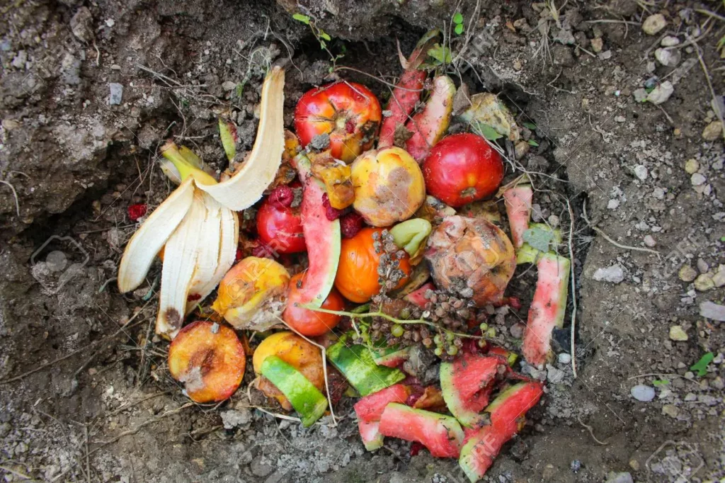
  1. Biodegradable solid wastes: Wastes like food leftovers, vegetable peels, old clothes, old newspapers, old calendars or used tea leaves that can be decomposed by microorganisms are biodegradable.
  2. Non-biodegradable solid wastes: Obsolete televisions, damaged mobile phones, broken cameras, broken utensils, broken glass items and damaged plastic furniture are some of the non-biodegradable solid wastes that cannot be decomposed by microorganisms.

2. Liquid wastes: Used water in bathrooms and kitchens, water disposed of after washing clothes and liquids of other types that are no more necessary are called liquid wastes.

Read and Learn Also WBBSE Solutions for Class 10 Geography and Environment

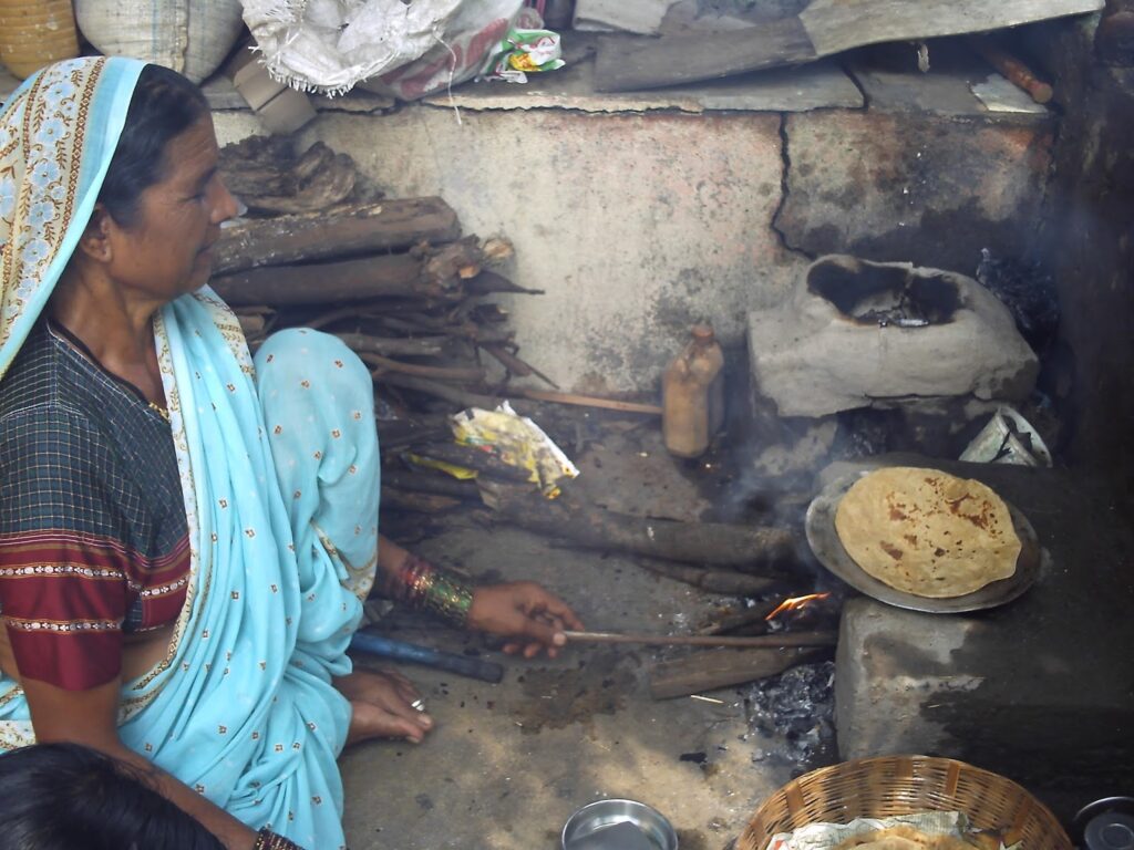
3. Gaseous wastes: Smoke coming out of kitchen chimneys, fuel wood, incense sticks and perfume sprays, and CFCs emitted by various electrical appliances like refrigerators and air conditioners are some of the gaseous wastes.


WBBSE Solutions Geography And environment Chapter 4 Waste management solid wastes

WBBSE Solutions Geography And environment Chapter 4 Waste management liquid wastes

WBBSE Solutions Geography And environment Chapter 4 Waste management Geseous water

Waste Management Techniques for Students

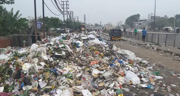
Question 2. What kind of waste is seen on the streets?
Answer:

Various kinds of waste are seen on the streets of both rural and urban areas-

1. Some citizens have a tendency of throwing litter on the streets from their windows or verandahs. This spreads litter all over the streets.

2. The municipality and corporation dump the solid wastes collected from the urban centres besides the roads before they are finally disposed of or treated. This causes the spread of bad odour.

WBBSE Solutions Geography And environment Chapter 4 Waste management people dumping wastes on the street

3. Litter and garbage are seen in parks, markets and street corners. Flies and insects sitting on them may cause infectious diseases.

4. Sometimes the sewage lines may get blocked and the open drains may overflow. Sewage water will then flood the roads and cause unhealthy conditions.

5. The factories and mills around the cities emit smoke throughout the day. This causes suffocation when we travel through those areas.

WBBSE Class 10 Geography Chapter 4 Question Answer

WBBSE Solutions for Class 10 History WBBSE Solutions for Class 10 Geography and Environment
WBBSE Class 10 History Long Answer Questions WBBSE Solutions for Class 10 Life Science And Environment
WBBSE Class 10 History Short Answer Questions WBBSE Solutions for Class 10 Maths
WBBSE Class 10 History Very Short Answer Questions WBBSE Solutions for Class 10 Physical Science and Environment
WBBSE Class 10 History Multiple Choice Questions


Question 3. Discuss the types of waste found in schools.
Answer:

Various types of waste are produced in schools.

1. Solid wastes: Both biodegradable and non-biodegradable wastes can be found in schools.

  1. Biodegradable: Food leftovers, pieces of paper, chalk, the dust of chalk, etc., are the biodegradable wastes produced in schools.
  2. Non-biodegradable: Refills of pens, plastics, water bottles, wrappers of cakes and candies and broken scales and sharpeners are some of the non-biodegradable wastes found in schools.

2. Liquid wastes: Liquid wastes include water disposed of toilets and wash basins.

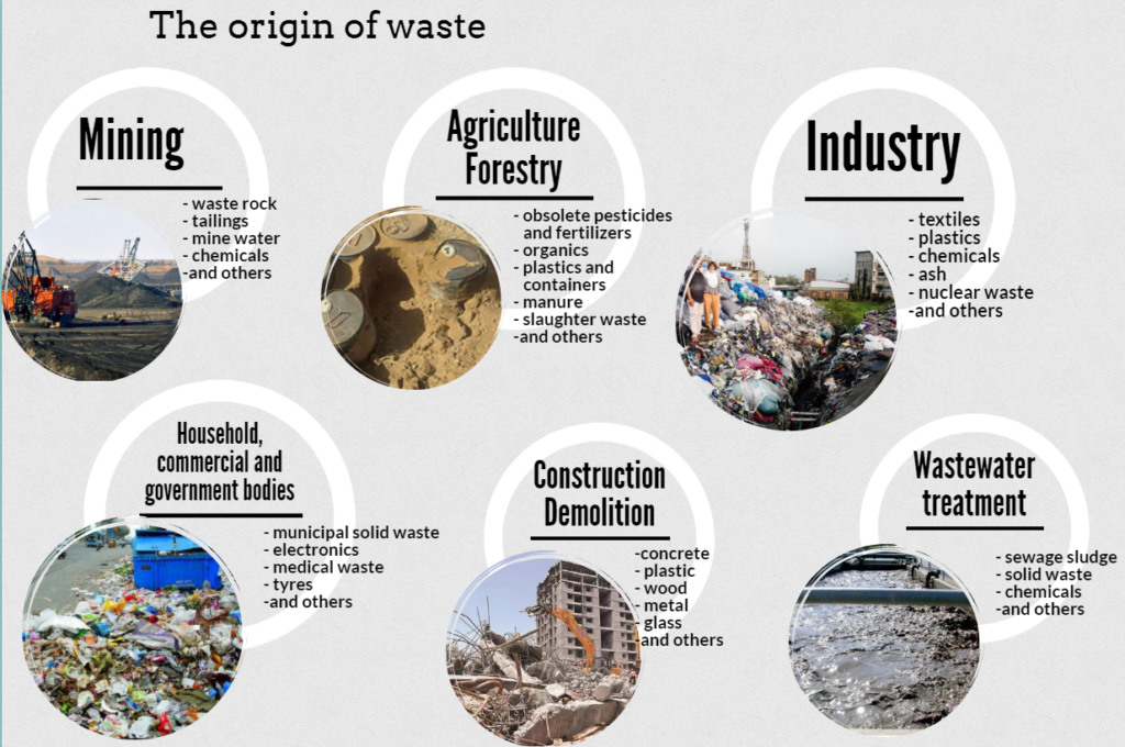
Question 4. Discuss the various sources of waste.
Answer:

Wastes can be generated from many sources.

1. Household wastes: These wastes are generated due to daily work in households, like cooking, gardening and cleaning.

WBBSE Solutions Geography And environment Chapter 4 Waste management Different sources of waste

Types of Waste Disposal Methods

2. Industrial wastes: These wastes are produced by big and small industries.

3. Agricultural wastes: This includes items produced during and after agricultural activities. Examples—Husks, hay, and roots of harvested crops.

4. Urban wastes: Such wastes are generated in urban areas. Examples—Obsolete computers, damaged mobiles, furniture and old-fashioned clothes.

5. Organic wastes: This includes wastes coming from biotic materials like agricultural wastes, food leftovers, old jute bags, etc.

6. Medical wastes: Used in injection syringes, bandages, cotton, tablet foils and catheters are some of the medical or hospital wastes.

7. Mining wastes: The wastes produced during mining activities are called mining wastes.

8. Radioactive wastes: Wastes produced in atomic research centres are called radioactive wastes.
about medical waste.

WBBSE Class 10 Geography Chapter 4 Question Answer

Question 5. Discuss Medical waste.
Answer:

Medical waste:

The wastes produced in hospitals, nursing homes, pathological laboratories and health centres are called medical wastes. They can be both infectious and non-infectious.

1. Infectious medical wastes: About 10-12% of medical wastes are infectious. They include-

  1. Used needles, syringes, knives, scissors, blades, catheters, etc.
  2. pathological and surgical wastes,
  3. used kinds of cotton, bandages, amputated body parts, plasters, etc.
  4. Medicines used in treatment.

2. Non-infectious wastes: About 90% of medical waste are non-infectious. They include-

  1. Plastic packets, plates, packets of medicines,
  2. Leftover food of patients,
  3. Office wastes, used and old papers, and foils of medicines.

Question 6. Discuss the solid wastes found in the environment.
Answer:

The wastes that lie in a solid state in the environment are called solid wastes.

Some of the solid wastes found in the environment are-

1. Household wastes: Household solid wastes include vegetable peels, food leftovers, plastic packets, old clothes, discarded blankets, dry flowers, old calenders, broken utensils, old shoes, old newspapers, broken glass and many more things.

2. Industrial wastes: The solid wastes coming from industries include discarded types of machinery, used plastic items, tyres, tubes, fly ash, chemical wastes, mineral wastes, etc.

3. Agricultural wastes: Solid wastes from agricultural activities include husk, sugarcane fibre, hay, wooden pieces, jute stems, animal wastes, dung, etc.

4. Pathological wastes: Pathological and medical wastes include used syringes, needles, knives, scissors, cotton, bandages, etc.

Question 7. Discuss the sources of liquid waste in the environment.
Answer:

The waste materials that exist in the liquid state in the environment are called liquid wastes.

The different sources of liquid wastes found in the environment are-

1. Household wastes: Water used for washing utensils and clothes, used water coming out of bathrooms and toilets, detergent water and the water left after wiping and mopping are some of the liquid wastes generated in households.

2. Industrial wastes: Water left after cleaning instruments, washing of ores and minerals, hot water from boilers, and water saturated with chemicals and oils are some of the liquid wastes that come out of industries.

3. Agricultural wastes: The fertilisers and insecticides used in agriculture are washed away by rainwater and added to the rivers or nearby waterbodies. This leads to the production of liquid wastes from agriculture.

Question 8. Discuss the gaseous wastes in the environment.
Answer:

The gaseous wastes in the environment

The gaseous materials coming out of the chimneys of factories, vehicles, research centres, power plants, households and other places which are harmful to the environment are called gaseous wastes.

They include carbon dioxide, methane, chlorofluorocarbons (CFCs), nitrogen oxide, oxides of sulphur, carbon monoxide, etc. These gaseous wastes result in global warming and the greenhouse effect. They are also responsible for environmental and climatic changes.

WBBSE Class 10 Geography Chapter 4 Question Answer

Question 9. Discuss the toxic wastes in the environment.
Answer:

The toxic wastes in the environment

The toxic wastes produced in the environment are very harmful and may even result in loss of life. These wastes can be divided into three types-

1. Chemical Wastes: The floor cleaning liquids, rat and pest killing chemicals, and insecticides which are harmful chemicals, that degrade environmental quality when disposed of in the environment.

2. Radioactive Wastes: The radioactive wastes emit harmful radiations that can result in cell damage and genetic disorders in animals, plants and human beings. They are emitted from X-rays, atomic energy centres and atomic explosions.

3. Medical wastes: Catheters, used needles, syringes, scissors, amputated body parts, and used cotton and bandages are some of the medical wastes. They are highly infectious and may cause harm.

Question 10. What is the nature of urban waste?
Answer:

The nature of urban waste

Wastes are produced every day in rural and urban areas. Large urban regions and metropolitan cities produce much more waste than smaller towns. Cities like Kolkata, Mumbai, Delhi and Chennai produce about 3000-5000 metric tons of waste every day.

This includes items like leaves of trees, straws, vegetable peels, burnt charcoal, broken glass and metal utensils, old paper, old clothes, stones, leather, plastic items, bones, ash, thermocol, bulbs and lights, electronic goods, food leftovers, carry bags, etc.

Question 11. What are biodegradable wastes?
Answer:

Biodegradable wastes

Biodegradable wastes are those that can be decomposed or broken up into simple components by microorganisms like bacteria.

The simple components can be easily absorbed by the soil. This helps to increase soil fertility. Some biodegradable wastes found around us are-vegetable peels, dry leaves and flowers, weeds removed from gardens, green coconut shells, old newspapers, books, old clothes, etc.

Importance of Recycling in Waste Management

Question 12. What are non-biodegradable wastes? How do they affect the environment?
Answer:

Non-biodegradable wastes

The wastes that cannot be decomposed by microorganisms are called non-biodegradable wastes.

They can be divided into three types-

1. Poisonous wastes: Chemical products, paints, bulbs, tubes, spray cans, insecticides, lead batteries and medicine bottles are some of the poisonous non-biodegradable wastes.

2. Recyclable wastes: Items like plastic goods, broken glass utensils, polythene packets or electric wires can be recycled and reused. Hence, they are called recyclable non-blodeRradable wastes.

3. Solid wastes: Hospital wastes like used syringes, saline bottles, used plasters, household wastes like old shoes, and obsolete electronic p.oods are some of the solid wastes that are non-bio-dep, readable.

Effects on the environment: The non-biodegradable wastes remain in the environment for a long time and may cause harm. They may spread infectious diseases and block the drainage and sewage systems.

But nowadays, these wastes are sorted and items made of plastic, glass and metal are recycled. This helps to reduce the amount of waste deposited in the environment.

WBBSE Class 10 Geography Chapter 4 Question Answer

Question 13. Discuss the effects of hospital waste disposal on human health.
Answer:

The effects of hospital waste disposal on human health

The wastes disposed of in hospitals, medical centres, health homes or dispensaries may be infectious and cause numerous health hazards for human beings.

The dumping of such wastes in open dustbins or streets causes air pollution of huge proportions. Rats, flies, moles and other insects sit on the wastes and tend to carry germs and spread diseases.

The common diseases caused this way are-

  1. Worms,
  2. Lung diseases,
  3. Tetanus,
  4. Hepatitis B,
  5. Peptic Ulcer,
  6. Skin diseases,
  7. Stomach problems,
  8. Jaundice,
  9. Eye diseases,
  10. Typhoid.

Composting Benefits for the Environment

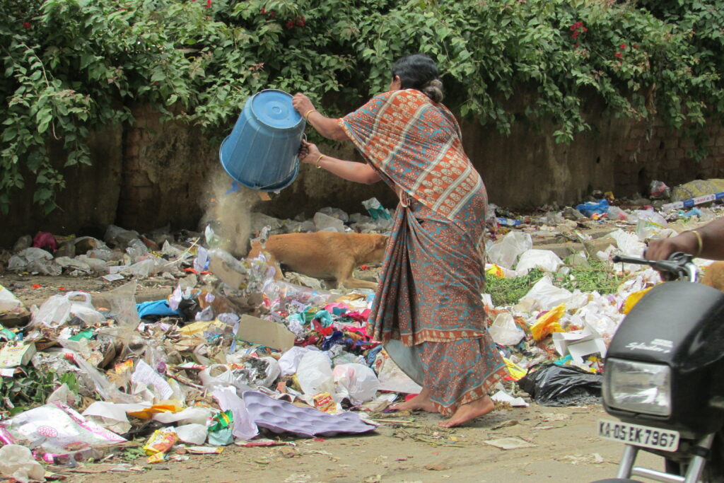
Question 14. What do you mean by ‘open dumping’?
Answer:

Open dumping

The wastes collected from urban areas are dumped in some open lowlands on the outskirts of these regions. This method of disposing of the waste is called ‘open dumping’.

This process does not require much planning and does not involve any huge expenditure. Sometimes, these wastes are set on fire to reduce their bulk.

But there are some disadvantages of open dumping—

  1. The garbage and wastes get washed away by rainwater and flow into the nearby waterbodies polluting them.
  2. The garbage and pollutants lie open on the ground and spread a very bad odour.
  3. They attract rats, moles, flies and insects which carry the dirt with them and spread diseases.
  4. Burning of these wastes causes air pollution.

WBBSE Solutions Geography And environment Chapter 4 Waste management Open Dumping

WBBSE Class 10 Geography Chapter 4 Question Answer

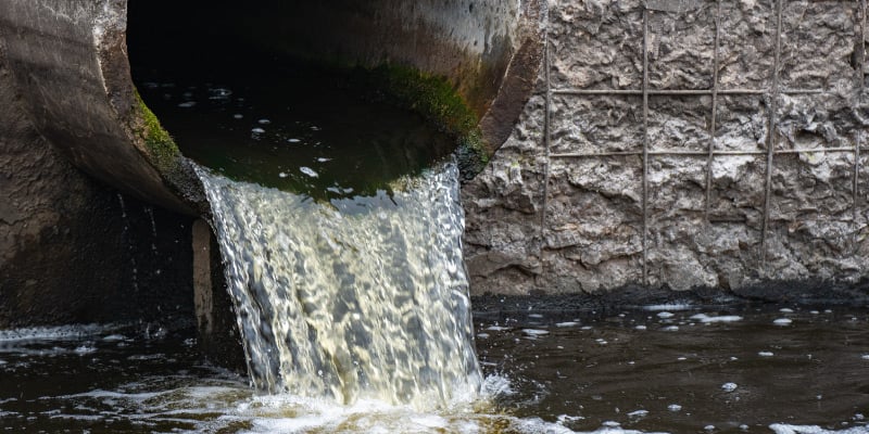
Question 15. How does waste disposal result in water pollution?
Answer:

Waste disposal is one of the main reasons for water pollution. Many people have a tendency of disposing of household wastes in ponds, lakes and rivers nearby.

Industrial wastes are also disposed of in rivers and oceans in many cases. Rainwater also washes down wastes disposed on the ground into water bodies. All these lead to the contamination of water and subsequently, result in high levels of pollution.

Water pollution is very harmful to aquatic plants and animals and may lead to the extinction of some species. The balance of the aquatic ecosystem is also disturbed as many species lose their reproductive capabilities, while some die early.

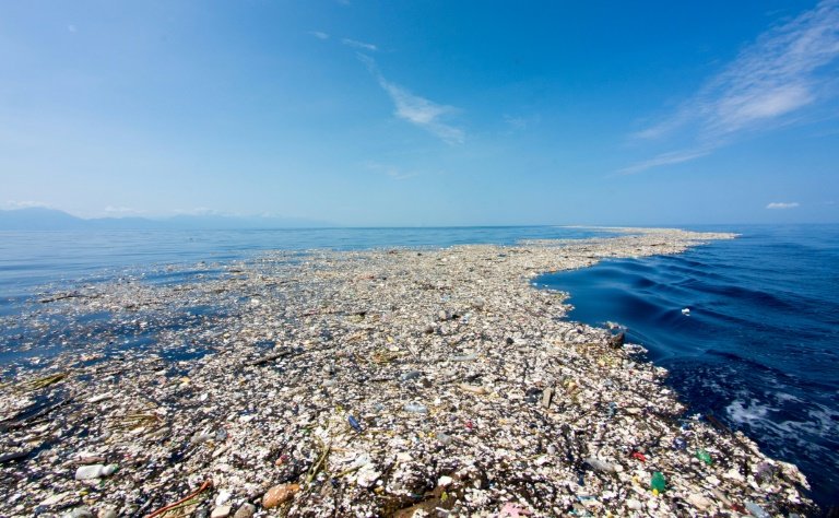
Question 16. Discuss the disadvantages of ‘ocean dumping’.
Answer:

The system of disposing of wastes in oceans is known as ocean dumping.

The disadvantages of ocean dumping are—

1. Oil leakage or oily products deliberately disposed of in oceans create a layer of oil on the ocean water. This disables the oceanic animals from breathing and may cause their death. The layer of oil also prevents sunlight from penetrating into the water.

This hampers the process of photosynthesis of oceanic plants and reduces the growth of plankton and corals.

2. The poisonous wastes disposed of in oceans are consumed by fish and other oceanic animals. This poisons the fish and when we consume those fishes, the harmful chemicals spread in our bodies and cause health problems.

3. The wastes disposed of in the oceans reduce the oxygen content of the water. This affects marine animals like seals, dolphins, sharks and fish and may cause their death.

4. Small items like bottle caps, machine parts and other choking items cause death when marine animals confuse them with food materials.

Waste Management Class 10 WBBSE

Question 17. How does waste disposal cause soil pollution?
Answer:

Waste disposal is one of the main causes of soil pollution.

The various causes are as follows—

1. The detergents, pesticides and chemical fertilisers disposed of in the soil tend to degrade the quality and fertility of the soil. They also tend to the quality and fertility of the soil. They also tend to kill useful bacteria and small animals and insects present in the soil.

2. Compounds of lead molybdenum and other poisonous elements reduce the quality and fertility of the soil and cause high levels of soil pollution.

3. Non-biodegradable items like plastic, polythene and broken glass change the soil’s character.

4. Atomic explosions and wastes coming from atomic research centres damage the fertility of soil permanently. The damage may be of such a scale that the soil remains poisonous for thousands of years.

5. Acid rain as a result of smoke emitted by vehicles and industries directly reaches the soil and releases toxic substances the soil and thus polluting it.

Question 18. What are safe pesticides?
Answer:

Safe pesticides

The use of pesticides is very common in agriculture for the protection of crops. Some pesticides are very harmful and may cause side effects.

But recently, the use of organic and environment-friendly pesticides has been popularised. These are called safe pesticides. Example—Neem oil. This does not cause pollution of soil, air or water.

Sanitary Landfills Explained

Question 19. ‘Wastes are the source of resources’- Explain.
Answer:

‘Wastes are the source of resources’

Wastes can be converted into resources if are properly used and utilised. In the present day, wastes are being treated by new technologies and are being put to valuable use.

Example— The fly ash coming from the thermal power plants is being used for making bricks, building roads, and filling lowlands; biotic wastes are being used to produce biotic fertilisers, fuel gas and electricity.

Such recycling and reusing of wastes into productive items reduce the pressure on the existing natural resources. Hence, it is rightly said that- ‘Wastes are the source of resources’.

Waste Management Class 10 WBBSE

Question 20. Name some harmful chemical wastes.
Answer:

Some of the harmful chemical wastes are-

  1. Benzidine: Used in paint factories.
  2. DDT: Used as a pesticide.
  3. Mercury: Used in many industries.
  4. Lead: Used in many industries.

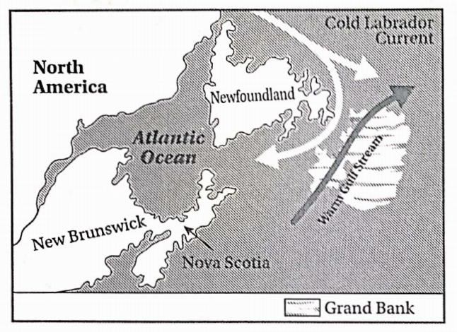
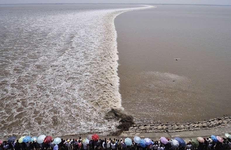
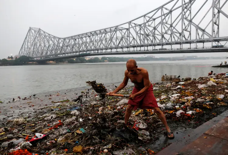
Question 21. How is the Bhagirathi-Hooghly river being polluted?
Answer:

The river Ganga is considered the lifeline of India. The last 600 km stretch of the river flowing through West Bengal till the river mouth in the Bay of Bengal is known as the Bhagirathi- Hooghly.

This part of the river Ganga is the most polluted due to the following reasons—

  1. The numerous factories located on the banks of the Bhagirathi-Hooghly river discharge their solid, liquid and poisonous wastes directly into the river.
  2. Pesticides, chemical fertilisers, biotic wastes and eroded soil are washed by rainwater and accumulated in the river.
  3. Disposal of dry flowers, plastics and other household wastes, dead bodies of animals and immersion of idols pollute the river.
  4. The garbage collected from the adjacent urban areas is often directly disposed of into the river.
  5. Leakage of fuel, burnt motor oil and lubricants from water vessels (boats, ships, etc.) also cause a lot of pollution in the river.
  6. Ash from burning ghats is often dumped into the river which causes high levels of pollution.

Question 22. What kind of environmental problems may arise from the pollution of the Bhagirathi-Hooghly river?
Answer:

The environmental problems that may arise from the pollution of the Bhagirathi- Hooghly river are-

  1. Expenses of purifying the river water to make it drinkable will increase manifolds.
  2. The polluted water used for agriculture will pollute the soil and harm the crops.
  3. Aquatic animals like fishes, crabs and insects as well as aquatic plants will die in the polluted water.
  4. Deposition of wastes in the river bed will decrease the depth of the river and increase the chances of flood in the adjacent areas.
  5. The load of wastes in the river will result in the collapse of the river banks, causing a loss of huge areas of agricultural fields.
  6. Wastes also hamper navigation and movement of water transport.

Waste Management Class 10 WBBSE

Question 23. What do you mean by hazardous waste?
Answer:

Hazardous waste

The chemical wastes that may cause harm to both the plant and animal kingdoms are called dangerous wastes.

Generally, they are combustible, highly reactive, poisonous or radioactive. They are usually generated in oil- refineries, metal extraction industries, chemical factories and atomic energy centres.

The different types of dangerous wastes are—

  1. Heavy metals: Lead, zinc, arsenic, etc.
  2. Petrochemical products: Grease, gasoline, lubricating oils.
  3. Artificial organic compounds: DDT, aldrin.
  4. Acids: Hydrogen chloride, hydrogen sulphide.
  5. Biotic elements: Bacteria, plant toxins.
  6. Radioactive elements: Radium, uranium.

Question 24. Discuss the effects of Waste disposal on the environment.
Answer:

The various effects of waste disposal on the environment are-

1. Visual pollution: Dumping of garbage and wastes here and there pollutes the place and looks displeasing. This causes light pollution.

2. Effect of poisonous wastes: Poisonous wastes coming from factories pollute the water, soil as well as air. They damage the ecosystem and cause various diseases in plants and animals.

3. Reduction of soil fertility: The wastes coming from households, agriculture, hospitals and industries disposed of in the soil cause pollution and reduce the fertility of the soil.

4. Effect on water: Wastes disposed of in waterbodies pollute the water and cause life risks to aquatic plants and animals. Their reproductive capabilities are also reduced.

5. Effect on air: Mixing of gaseous wastes in the air cause air pollution. This increases the air temperature gradually and adds up to the causes of global warming. Open dumping of wastes also produces a foul smell.

6. Destruction of biodiversity: Poisonous and harmful wastes cause the destruction of biodiversity of wetlands, forests and water bodies.

7. Effect on human beings: Solid wastes are responsible for diseases like typhoid, jaundice, diarrhoea, skin diseases, lung diseases, etc.

Waste Management Class 10 WBBSE

Question 25. What are the sources of solid waste?
Answer:

The various sources of solid wastes are-

1. Households: Food leftovers, packets of spices, vegetable peels, old newspapers, plastic containers, glass bottles, old beddings, clothes, broken electronic devices, fans, shoes, etc., are wastes generated in households.

2. Agriculture: Wastes generated from agriculture include husks of grains, the fibre of sugarcane, jute, animal dung, dry leaves, DDT, containers of pesticides, and empty bags of fertilisers and seeds.

3. Industries: Industrial wastes include discarded metallic items, fly ash from thermal power plants, sludge, packing boxes, harmful chemicals and gases.

4. Hospitals: Hospitals and medical centres generate wastes like medicine bottles, tablet foils, syringes, blades, scissors, used cotton and bandages and amputated body parts.

Incineration Process and Its Impact

Question 26. What kind of problems may arise from different sources of waste?
Answer:

The various kinds of problems arising from various sources of waste are—

1. Medical wastes: Infectious diseases like tetanus, diarrhoea, hepatitis and skin diseases, AIDS, lung diseases and worm-related problems may occur even in the slightest contact with contaminated medical wastes.

2. Agriculture: Agricultural wastes cause the destruction of the ecosystem of both soil and water. Plastics and containers disposed of in the soil pollute it and hamper plant growth. Worms, dysentery, lung diseases, and stomach problems may occur.

3. Industries: Industrial wastes disposed in rivers or on the ground cause water and soil pollution. They cause many health problems and diseases.

4. Construction: Cement, sand, paints and varnishes used in construction works cause soil pollution. They reduce soil fertility. They also cause several lung and stomach diseases.

5. Radioactive wastes: Radioactive wastes are the most harmful wastes of all. They pollute the soil and water. They may cause genetic diseases in both plants and animals as they emit radiation.

Waste Management Class 10 WBBSE

Question 27. Name some diseases caused by solid waste.
Answer:

Solid wastes may cause diseases like typhoid, dysentery, diarrhoea, skin diseases and other work-related diseases. The people directly involved with the collection and disposal of solid wastes are more prone to these diseases.

Question 28. What kind of waste is plastic? What environmental hazards does it cause?
Answer:

Plastic is a solid non-biodegradable product. It cannot be decomposed and remains in the soil for a very long time. It causes soil and water pollution.

It blocks the sewage lines and causes water logging after heavy rainfall. It causes tremendous air pollution when burnt.

Question 29. List the problems caused by the dumping of wastes openly.
Answer:

The problems caused by dumping wastes openly are—

  1. Rats, moles, flies and insects sit on the garbage and wastes dumped openly, thereby spreading diseases.
  2. Open garbage and wastes spread bad odour and cause air pollution.
  3. Burning of these wastes also causes air pollution.
  4. The dump yards also occupy a lot of space, which can be put to other uses.

Question 30. List the wastes generated from construction works.
Answer:

The wastes generated from construction works Are

The wastes generated from construction works are bricks, wood, stones, sand, cement, plastic, pieces of iron, ceramic tiles, fittings, containers of paints and used brushes.

Presently, a large portion of air, water and soil pollution is caused by the wastes coming from construction works.


WBBSE Sloutions Geography And environment Chapter 4 Waste management Wastes generated through constructional work


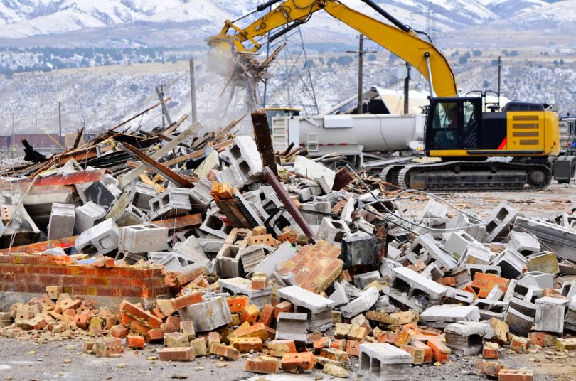
Question 31. Discuss the problems created by construction waste.
Answer:

The problems created by construction waste

The wastes generated from construction works, for Example— bricks, stones, cement and sand, lead to lung and stomach diseases of labourers directly involved with the work.

Apart from that, the spreading of such wastes into the soil reduces soil fertility and hampers plant growth. The suspended particles of waste in the air cause air pollution.

Question 32. How do industrial wastes cause harm?
Answer:

Industrial wastes disposed of in rivers and waterbodies pollute the water, causing harm to aquatic plants and animals.

The ecosystems are destroyed and the ecological balance of the environment is disturbed. The wastes disposed on the ground cause severe soil pollution.

Soil fertility is reduced remarkably. The soil may become unfit for agriculture. Gaseous wastes from industries pollute the air.

Waste Minimization Strategies

Question 33. Differentiate between liquid wastes and solid wastes.
Answer:

The differences between liquid wastes and solid wastes are-


Point of difference Liquid wastes Solid wastes
Nature Exist in a liquid state under normal environmental conditions. Exist in a solid state under normal environmental conditions.
Source Hot water from thermal power plants, industrial wastes, sewage water, etc. Kitchen, household, industries, etc.


Question 34. Differentiate between poisonous and Non-poisonous wastes.
Answer:

The differences between poisonous and Non-poisonous wastes are-


Point of difference Poisonous wastes  Non-poisonous wastes
Concept Such wastes cause harm or even the death of plants and animals. Such wastes are usually harmless, rather may even be environment-friendly.
Mature They are non-biodegradable. They are generally biodegradable.
Examples Polymer, polythene, radioactive wastes. Vegetable peels, husks of grains, wood, and paper.


Question 34. Differentiate between biodegradable and non-biodegradable wastes.
Answer:

The differences between biodegradable and non-biodegradable wastes are-


Point of difference Biodegradable wastes Non-biodegradable wastes
Concept Can be decomposed by various bacteria, viruses and other microbes. Cannot be decomposed by any bacteria, virus or other microbes.
Stability Such wastes easily get absorbed in nature. Such wastes are not absorbed in nature.
Types A single type of waste. May be classified into three types— poisonous wastes, recyclable wastes and solid wastes.
Examples Dry flowers, leaves, vegetable peels, and food leftovers. Spray cans, expired medicines, and medical wastes.


Question 36. How should waste be managed in households?
Answer:

Wastes may be managed in households in different ways in order to maintain hygiene and reduce the volume of waste produced.

1. Reducing the amount of waste produced: The basic idea of waste management is producing less amount of waste. If the number of waste produced can be decreased, then hygiene and environmental quality will be maintained automatically.

2. Reuse: Some wastes generated in households may be reused. E.g.—used or empty bottles and jars may be used as flower vases, and old clothes may be used as rugs.

3. Recycling: Some wastes may be recycled and put to a different use, thus reducing the number of wastes generated. E.g.—old newspapers may be sold off, to be converted into pulp for making fresh paper, used tea leaves and vegetable peels may be used for preparing biotic fertilisers for gardening.

4. Use of modern substitutes: Using modern and convenient consumer goods help to reduce the levels of waste produced in households. E.g.—The use of liquid detergents for washing clothes produces a lesser amount of liquid waste, and the use of tissue paper reduces the amount of wastewater coming from water basins.

Question 37. Discuss the advantages and disadvantages of the landfilling methods.
Answer:

The method of landfilling has many advantages as well as disadvantages.

Advantages:

  1. The wastes remain covered with a layer of soil. Hence, there is less chance of spreading diseases by germs and microbes.
  2. The wastes being covered, produce no bad odour or cause air pollution.
  3. There is no chance of the wastes catching fire, as they are covered with soil.
  4. The decomposition of the wastes produces several gases that can be easily collected without spreading them in the air.

Disadvantages:

  1. Rainwater percolates through the wastes in the landfill and causes severe soil pollution.
  2. Rainwater percolating through the wastes dissolves numerous pollutants and became polluted. This polluted water leaking out of landfills is known as
  3. ‘leachate’. The leachate may flow into rivers, ponds and lakes and cause severe water pollution. It can also percolate deep into the underground and pollute the groundwater.

Question 38. How are wastes reduced by burning?
Answer:

Burning is an easy and popular method of reducing the volume of waste. This is generally practised in industrial regions or in places where there is a lack of space for dumping.

While burning, things like molten glass and metals may be extracted. In the case of petrochemical industries, the tar and the sticky and boggy petroleum wastes may be burnt to produce heat.

This may help to generate electricity. But burning in the open air causes air pollution. Huge amounts of fly ash, carbon dioxide, hydrogen chloride and hydrogen sulphide thus produced, degrade environmental quality.

Hazardous Waste Management Practices

Question 39. Describe the method of sanitary landfilling.
Answer:

The method of sanitary landfilling

Sanitary landfilling is an important method of managing solid waste. The biodegradable materials are separated from the waste and spread over the specific land.

This layer of biotic waste is about 2m high. A 20-25 cm thick layer of soil is spread over this layer. This way, alternate layers of wastes and soil are arranged a number of times.

In the end, a thick layer of soil (about lm) is spread to cover the whole dump, so that rats and moles cannot enter easily. The bacteria present in the soil help in the chemical decomposition of the biotic wastes.

Gases like methane, carbon dioxide and ammonia are released beneath the layer of soil. Within 4-6 months, the total waste is decomposed into harmless compounds.

Question 40. What is a manure pit?
Answer:

Manure pit:

In the rural areas in India, there is a lack of proper waste disposal systems. People have a tendency of throwing garbage here and there, which causes a lot of environmental pollution.

To solve this problem, the method of waste management by ‘manure pits’ is used nowadays.


WBBSE Solutions Geography And environment Chapter 4 Waste management Manure Pit


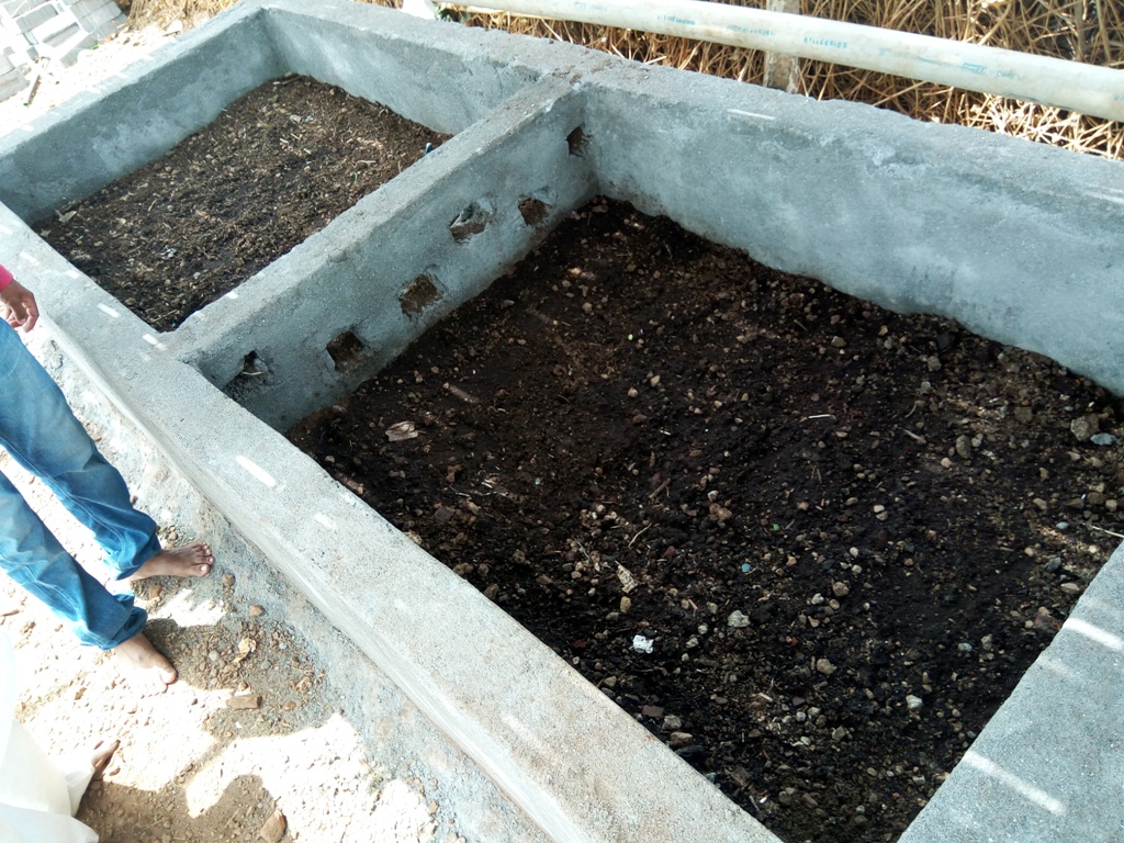
In this method, a deep ditch or pit is dug in the ground. Garbages like vegetable peels, wasted food, cow dung and other household wastes are thrown into the pit every day and covered with a thin layer of soil.

Once the pit gets completely filled up, it is permanently covered with soil. Within 5-6 months, the wastes are decomposed into manure. This manure is used as fertiliser in agriculture.

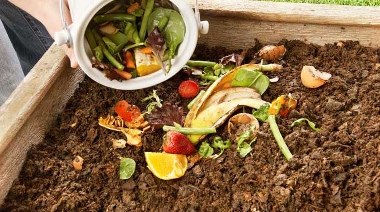
Question 41. How is the method of ‘composting’ useful?
Answer:

Composting is a method of converting biotic wastes into humus with the help of microorganisms.

The carbon dioxide, water and heat produced while decomposing biotic wastes into compost help to destroy the larva of flies, harmful bacteria and weeds.

The biotic fertilisers thus produced are rich in nitrogen and phosphate, which is good for the growth of plants.


WBBSE Solutions Geography And environment Chapter 4 Waste management Composting


Question 42. Describe incineration as a modem method of burning harmful wastes.
Answer:

Burning harmful wastes openly in the environment causes severe pollution and degradation of the environment.

Hence, modern methods such as incineration are being put into practice to manage these wastes. This is an expensive method, but relatively friendly to the environment.

The tremendous heat produced while burning the wastes in incinerators (furnaces) is often put to other uses.

This helps to reduce the per capita expense. But this method does not fully succeed in burning all the waste materials. Some portions of the waste remain unburned. These are collected later, disposed of by landfilling or emptied into the oceans.

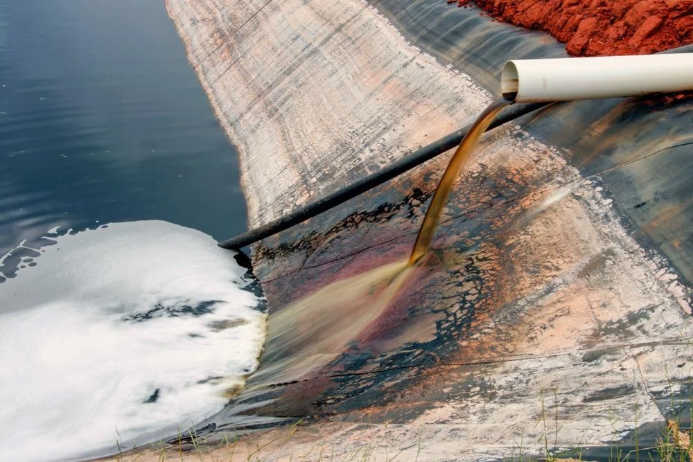
Question 43. How Can water be disposed of by industries or purified?
Answer:

The water disposed of by industries and sewage pipes of towns and cities is saturated with acids, chemicals and other abiotic materials.

This water must be treated chemically and purified before disposal in order to control environmental pollution.

Several plants have been set up that help to remove the harmful materials from this water and reduce the level of pollutants in it.

Question 44. How is water made germ free in the process of purification?
Answer:

The microorganisms like bacteria, viruses and other germs live in water with the help of the oxygen dissolved in it.

If the level of oxygen in the water can be reduced and a deficiency of oxygen can be created, then the water can be made germ free.

Question 45. What are the different plans or programmes taken up in the Ganga Action Plan?
Answer:

The first phase of the Ganga Action Plan began in 1985 and the second phase was started in stages between 1993-96.

The important programmes taken up in the plan are as follows—

  1. During the first phase, steps were taken to purify the sewage water of 25 Class I cities in India.
  2. Steps have been taken to ensure that polluted and contaminated water is not disposed of directly into the Ganga.
  3. Measures have been taken to ensure the perennial flow of water in the river Ganga. Steps have been taken to improve water quality to acceptable standards and prevent pollution load from reaching the river. In the second phase of the plan, river cleaning was extended to other rivers as well.
  4. The growth of brickfields and such allied factories has been restricted along the banks of the river.
  5. Steps have been taken to ensure that no industry lying on the banks of the river disposes of its solid and liquid wastes directly into the river.

Question 46. What is the necessity of keeping the Bhagirathi-Hooghly river pollution free?
Answer:

The Bhagirathi-Hooghly river must be kept pollution free for the following reasons-

1. Depth of the river: The solid wastes dumped into the river Bhagirathi-Hooghly gets accumulated on the river bed, thereby reducing the depth of the river. This is one of the major causes of floods on its adjacent banks.

If the disposal of such wastes can be controlled, the depth of the river can be maintained. This may help to control floods.

2. Ecosystem: Pollution of water causes harm to the aquatic ecosystem. As a result, many species of plants and animals may get extinct.

If the pollution of water in this river can be controlled, the aquatic plants and animals can also survive and the balance of the ecosystem can also be maintained.

3. Drinking water: A huge number of people residing along the banks of the Bhagirathi- Hooghly river use the water for drinking. If the water can be made pollution-free, people can get safe and pure drinking water from this river.

4. Soil pollution: The polluted water of river used in agriculture lead to soil pollution indirectly. If the level of pollution of the Bhagirathi-Hooghly river can be controlled, soil pollution will be controlled automatically. This will help in better crop production.

5. Agriculture and Irrigation: If pollution of the Bhagirathi-Hooghly river can be controlled, the water can be safely used for irrigation and agriculture, dams can be constructed where necessary and the water can be put to various uses.


WBBSE Solutions Geography And environment Chapter 4 Waste management Pollution on the banks of Bhagirathi-Hoogly


Question 47. What is the significance of the Ganga Action Plan with respect to the environment?
Answer:

The significance of the Ganga Action Plan with respect to the environment

The Ganga is the most important river in India. About 32% of the total water resource of India comes from the Ganga and its tributaries.

More than 40% of India’s population resides along the banks of the Ganga and its catchment area.

The water of the Ganga is important for agriculture, irrigation, industries, navigation, household works as well as drinking.

It helps to maintain a large portion of the aquatic ecosystem. Hence, maintenance of the river and its catchment area is very significant with respect to the environment.

Plans and programmes like the ‘Ganga Action Plan’ have been taken up to stop the degradation of the river water and bring about the development of the whole catchment area.

Question 48. How can waste or discarded water be purified?
Answer:

Wastewater coming from households, industries, farms or other places can be purified by certain processes. These are—

1. Primary Purification: The first step towards the purification of wastewater is the removal of floating and suspended materials with the help of a strainer. Then j the strained water is passed through several layers of pebbles, stones and sand to filter the impurities.

2. Secondary purification with the help of a biotic medium: In this phase, the; Biological Oxygen Demand (BOD) of water is reduced with the help of an organic medium.

In this process, the reaction of organic medium with the polluted water produces a; lot of sludge that floats over the water. This is removed to purify the water.

3. Final stage of purification: In this phase, the water is transferred into a huge ‘ reservoir for a few weeks. During this time, the nitrogen, phosphorus and other harmful compounds are removed and the water is finally purified.

Question 49. What are the various methods of removing solid wastes?
Answer:

The solid wastes are managed and removed in the following ways—

1. Open Dumping: The solid wastes collected from towns and cities are dumped in an open space outside the town. This is a primitive method of disposing of solid wastes and this causes too much pollution.

2. Sanitary landfill: In this method, the solid wastes are spread on open land and covered with soil. This is left for a few months. The bacteria present in the soil help to decompose the wastes and reduce their volume.

3. Manure Pit: In rural areas, the biotic wastes like vegetable peels, wasted food, leaves of trees and cow dung are disposed of in a deep pit and covered with soil. Within a few months, the waste is converted into biotic fertilisers that are very helpful for agriculture.

4. Compost: In this method, the biotic wastes, cow dung, etc. are converted into humus, which makes the soil fertile and helps in agriculture.

5. Burning: The wastes that are not biodegradable are usually reduced in volume by burning. But this method is not environment-friendly. Burning of plastics, polythene and other harmful solid wastes leads to too much pollution.

Question 50. Name some wastes that can be recycled.
Answer:

Some wastes that can be recycled

The recycling of solid wastes helps to reduce the volume of wastes and also serves as useful materials for some or other purposes.

1. Fly ash: Fly ash produced in thermal power plants is used as a raw material while manufacturing cement. It is also used for filling up lowlands, constructing of roads, making bricks and building low dams across rivers.

2. Bagasse: The sugarcane fibre or bagasse discarded from sugar mills is used to produce pulp needed in the manufacturing of paper.

3. Glass: Broken glass is melted and reshaped to make various items like bottles, jars or show pieces.

4. Paper: Old newspapers, used copies and books, cardboard, etc. are used to prepare pulp to make fresh paper once again.

5. Plastic: Old plastic toys, broken chairs, and discarded containers can be melted to manufacture new plastic items.

6. Metals: Waste metals like iron, tin or aluminium containers, broken furniture, etc. are melted or remodelled into new items.

Question 51. How is power produced from waste materials?
Answer:

One of the main objectives of waste management is to produce some useful things from the waste that may be used as a resource.

Waste materials help in generating power in the following ways—

1. Burning of biotic wastes: Husk of grains, the fibre of sugarcane, leaves and branches of trees, firewood and other biotic wastes may be burnt to produce heat. This heat can be used to generate power through advanced machines.

2. Pyrolysis: Pyrolysis is the heating of an organic material in the absence of oxygen. Because there is no oxygen, there is no chance of combustion. But the material decomposes into combustible gases and charcoal. These are used as fuels in different cases.

3. Producing combustible gas from organic wastes: Organic wastes like household wastes, agricultural wastes and leaves and branches of trees are processed through an instrument called a Gasifier to produce combustible gases.

4. Producing combustible gas through biochemical methods: Combustible gases can also be produced by biochemical methods. Bacteria is used for the decomposition of organic wastes, which produce methane gas. Presently, combustible gases are also produced in the landfill method of waste disposal.

Waste Management Project Class 10 WBBSE

Question 52. What do you know about ‘Swachh Bharat Avinyan’?
Answer:

Swachh Bharat Avinyan

The ‘Swachh Bharat Avinyan’ is a mission taken up in India at the national level, whose basic aim is to build a clean country. Several cities have been brought under this project.

Commencement: The project was officially started on 2nd October 2014, by the Prime Minister of India Sri Narendra Modi. This is the biggest cleanliness project taken up in India so far, where more than 3 million government employees and students are taking part.

Objectives: The project was taken up with the objective of making India clean and tidy by the 150th birth anniversary of Mahatma Gandhi on 2nd October 2019.

The main steps taken up in the project are—

  1. Preventing open defecation.
  2. Turning the unhygienic toilets into hygienic ones.
  3. Preventing cleaning of garbage manually.
  4. Recycling and reusing of solid wastes collected from urban centres.
  5. Building healthy and waste-free environmental conditions and spreading awareness among the common men regarding cleanliness.
  6. Helping the related organisations in the total cleaning and processing of wastes collected from urban areas.

Question 53. Discuss the role of students in waste management.
Answer:

The students may play a very important and significant role in waste management.

Waste Management Project Class 10 WBBSE

1. Producing less waste: Students can utilise their belongings like paper, pencils and pens to the maximum and produce fewer amounts of waste.

2. Keeping classrooms and households clean: The students can keep their classrooms and houses clean by not littering things here and there.

3. Helping in disposing of wastes: The students can help to dispose of wastes generated in school or house. They can also reuse certain wastes to make productive items. E.g.— empty cans can be used as pen stands.

Methods Of Waste Disposal Class 10 WBBSE

4. Discussions and debates: Discussions and debates can be arranged by eco clubs in schools and localities in order to spread awareness regarding waste disposal and its effects. Poster-making and drawing competitions related to waste management can also be arranged.

5. Creativity: Workshops can be arranged where students can be taught to make useful and attractive items using simple waste materials like old newspapers, cardboard boxes, empty bottles, etc.

Question 54. Discuss the methods of managing gaseous wastes, with the help of a scrubber.
Answer:

The gaseous wastes are usually managed with the help of an instrument known as the scrubber.

The scrubber is used in two ways to remove pollutants and impurities from gases—

1. Wet Scrubbing: In this case, the poisonous gases coming out of the chimneys of industries are first brought in contact with a scrubbing liquid which helps to remove pollutants. Thus, the gas released after treatment will be free from harmful pollutants.

2. Dry scrubbing: In this case, the poisonous gases coming out of the chimneys of industries are directly passed through the scrubber.

The pollutants are destroyed in this process and the gases released from the scrubber are free from harmful pollutants. Usually, acidic gases are purified by the method of dry scrubbing.

Question 55. Why is it not suitable to bum solid wastes?
Answer:

The burning of solid wastes produce harmful gases like sulphur dioxide, hydrogen fluoride, carbon dioxide and carbon monoxide. These gases cause immense air pollution and lead to global warming. Thus, it is not suitable to burn solid wastes

Methods Of Waste Disposal Class 10 WBBSE

Question 56. What happens if wastes are not disposed of in time?
Answer:

Accumulation of wastes here and there leads to the multiplication of bacteria and germs and results in the spread of infectious diseases.

Heaps of waste look ugly and hamper the beauty and cleanliness of a place. Hence, it is very important to dispose of waste in proper places at regular intervals in order to prevent environmental degradation.

Question 57. What do you mean by waste management?
Answer:

Waste management

Waste management refers to the reduction of the volume of waste, recycling and reusing them scientifically. Accumulation of wastes here and there looks ugly and untidy and spreads diseases.

Also, unless the wastes are managed, their volume will go on an increasing manifold in the environment with time, as wastes are produced in all spheres of life. Examples- Schools, offices, households, industries, power plants, agriculture, etc.

Question 58. How can waste water be purified and made germ free?
Answer:

Polluted and impure water is made germ free with the help of ultraviolet rays and ozone gas. Chlorine gas also helps to remove germs from the water. In households, water is made pure and germ-free by boiling it.

Question 59. Discuss the method of garbage collection in the developed countries of the world.
Answer:

In the developed countries of the world, garbage is not collected every day. Rather, large bins are left in the localities where garbage from households Is disposed of every day.

The garbage collecting van comes 3-d limes and the cleaning staff empties the large bins into the van. This Is how the cleanliness, hygiene and tidiness of the place are maintained.

Question 60. Why is the importance of fly ash Increasing day by day?
Answer:

The ash generated in thermal power plants after burning coal is known as fly ash.

This is used in manufacturing cement, making bricks, filling up lowlands and building small dams across rivers. Thus, the importance of ash is increasing day by day.

Methods Of Waste Disposal Class 10 WBBSE

Question 61. Why are old papers considered resources?
Answer:

Old papers are used in producing pulp, which is recycled to produce new and fresh paper. The pulp is also used to produce cardboard, newsprint, paper bags, handicrafts and even false ceilings.

Question 62. How can waste production be controlled at home?
Answer:

Wastes are generated in every walk of life- in schools, colleges, offices, factories, industries, the agriculture sector, etc.

Waste management should start at home. Students may play a vital role in the disposal and management of waste.

The amount of waste produced can be controlled by preventing misuse of resources, The collected waste must be kept in a properly covered place, at home, so that files and mosquitoes cannot sit on them and spread diseases, fiery.

These wastes should be disposed of in garbage collection vans or waste compressing machines. This is how waste products can be controlled at home.

Waste production can be controlled by managing the wastes already produced, by the methods of reducing and reusing.

Question 63. How are reduction wastes made?
Answer:

The reduction of waste can be made in the following ways—

  1. The manufacture and use of different objects must be done in a controlled manner,
  2. Quality of living should be modified so as to curb one’s needs.
  3. One should avoid wasting things.
  4. Implementation of advanced technologies in factories so as to minimise waste generation.
  5. Used items can be recycled or reused.
  6. Buying good quality products so that they can last for a long time.
  7. Encouraging the use of biodegradable and eco-friendly products.
  8. Making people aware of the ill effects of waste generation.

Question 64. What are the methods of controlling gaseous waste material?
Answer:

The gaseous wastes are usually managed with the help of an instrument known as the scrubber.

The scrubber is used in two ways to remove pollutants and impurities from gases—

  1. Wet Scrubbing: In this case, the poisonous gases coming out of the chimneys of industries are first brought in contact with a scrubbing liquid which helps to remove pollutants. Thus, the gas released after treatment will be free from harmful pollutants.
  2. Dry scrubbing: In this case, the poisonous gases coming out of the chimneys of industries are directly passed through the scrubber. The pollutants are destroyed in this process and the gases released from the scrubber are free from harmful pollutants. Usually, acidic gases are purified by the method of dry scrubbing.

Methods Of Waste Disposal Class 10 WBBSE

Chapter 4 Waste Management Short Answer Type Questions


Question 1. What do you mean by garbage?
Answer:

Garbage

The unnecessary items that we discard and dispose of every day is known as garbage. Examples—Vegetable peels, sugarcane fibre, agricultural wastes, etc.

Question 2. What do you mean by rubbish?
Answer:

Rubbish

The combustible or non-combustible solid wastes left over after the use of the necessary items is called rubbish. Examples—Old newspapers, wood, rubber, metals, and glass.

Question 3. What are industrial wastes?
Answer:

Industrial wastes

The waste materials produced in industries before, during and after the manufacturing and processing of products are called industrial wastes.

Example—Materials left behind during extraction of metals and minerals from ores, paints, chemicals, ash, etc. These wastes may cause harm if they directly come into the environment.

Methods Of Waste Disposal Class 10 WBBSE

Question 4. What are hospital or medical wastes?
Answer:

Hospital or medical wastes

The wastes generated from hospitals or after medical treatments are called hospital or medical wastes.

Examples—Tablet foils, injection syringes, cotton, expired medicines, used bandages, test tubes, plasters and catheters. These wastes can be poisonous and may cause infections.

Question 5. What do you mean by open dumping?
Answer:

Open dumping

The method of dumping wastes, usually urban wastes in open lowlands, away from residential areas is called open dumping. This is an easy and cheap method of disposing of waste as it does not incur a high cost.

Example—Dhapa region of Kolkata.

Question 6. What are biodegradable wastes?
Answer:

Biodegradable wastes

Biodegradable wastes are those that can be degraded and absorbed back into nature with the help of the microorganisms present in the soil or water.

Example—Vegetables, leaves, flowers, and roots of harvested crops.

Question 7. What are non-biodegradable wastes?
Answer:

Non-biodegradable wastes

The wastes that cannot be degraded or broken by the microorganisms present in the environment are called non-biodegradable wastes. They remain as it is after being discarded.

Examples—Plastic, glass, polythene, DDT. They are harmful to the environment.

Question 8. What are toxic wastes?
Answer:

Toxic wastes

The non-biodegradable wastes that cause harm to the environment and biotic life are called toxic wastes.

Examples—are DDT, plastic, insecticides and medical wastes.

Question 9. What are non-poisonous wastes?
Answer:

Non-poisonous wastes

The wastes that usually cause very little harm to living beings or have a nominal effect on the environment are called non-poisonous wastes. They are usually biodegradable.

Examples— Vegetable peels, leftover food or agricultural wastes.

Methods Of Waste Disposal Class 10 WBBSE

Question 10. What is bagasse?
Answer:

Bagasse

Bagasse is the fibrous matter or dry pulp left after the crushing of sugarcanes and extraction of their juice. It is used as a biofuel and in the manufacturing of pulp for the paper industry.

The use of bagasse in the paper industry has considerably reduced the felling of trees for making pulp.

Question 11. What do you mean by environment-friendly waste?
Answer:

Environment-friendly waste

The wastes that do not cause any harm to the environment are called environment-friendly wastes.

Examples— Tin, iron, steel, jute, and paper.

Question 12. What are the causes of the high rate of pollution of the Bhagirathi-Hooghly river?
Answer:

The causes of the high rate of pollution of the Bhagirathi-Hooghly river

The numerous factories and mills along the banks of the Bhagirathi-Hooghly river dispose of their solid and liquid wastes in the river itself.

Immersion of idols, washing and bathing, leakage of mineral oil and motor oil from water vessels and wastes from the Haldia Petrochemicals Industry add to the high rate of pollution of the Bhagirathi-Hooghly river.

Question 13. Write two bad effects of solid wastes on the environment.
Answer:

Two bad effects of solid wastes on the environment are—

  1. Solid wastes lying in the soil for a long time cause soil and also water pollution if washed down to the nearby water bodies. This may cause harm to plants and animals.
  2. Solid wastes like plastics or thermocouples may block the sewage lines and cause waterlogging.

Question 14. Why is pollution caused by waste also called ‘third pollution’?
Answer:

In the present world, pollution caused by waste disposal is very high, just after water and air pollution. Hence, it is also called the ‘third pollution’.

Question 15. What kind of health hazards are caused by radioactive wastes?
Answer:

Radioactive wastes may cause health hazards like the destruction of cells, cancer in different body parts and damage to the foetus. They may cause various kinds of harm if they remain in the environment for a long time.

Question 16. What do you mean by liquid waste?
Answer:

Liquid waste

The liquid materials that have no more use and cannot be recycled and reused, rather they cause harm called liquid wastes. They can be both poisonous and non-poisonous.

Examples— Sewage water, liquid fat oil used in households and industries, and water filled with chemicals disposed of in factories.

Question 17. What do you mean by solid urban waste?
Answer:

Solid urban waste:

The solid wastes produced in municipal and corporate areas due to the process of urbanisation is called solid urban wastes.

Examples—Leftover food, vegetable peels, old newspapers, broken glass and obsolete furniture.

What Is Waste Management Class 10 WBBSE

Question 18. What do you mean by ‘ocean dumping’?
Answer:

Ocean dumping

The process of dumping different kinds of wastes into oceans is known as ‘ocean dumping’.

For example—the USA is dumping about 2 crore tons of waste per year in the ocean, 300 km away from the coast, where the depth of water is about 1000 feet.

Countries like Iran, Japan and Hong Kong also practice ocean dumping. According to ocean conservancy, China, Indonesia, Philippines, Thailand and Vietnam account for about 60% of the plastic waste dumped in oceans.


WBBSE Solutions Geography And environment Chapter 4 Waste management Ocean dumping


Question 19. What do you mean by reuse of waste?
Answer:

Reuse of waste

The method of using discarded or rejected materials for some other purpose by bringing about simple modifications in the product is called the reuse of waste.

E.g.— A rejected dress can be reused as a rug. An empty jar of jam can be reused as a flower vase.

Question 20. What do you mean by recycling?
Answer:

Recycling

The method of producing new things from old disposed of items is called recycling. This is a good method of reducing and contracting waste. This also helps in the conservation of natural resources.

E.g.—Manufacturing paper from old newspapers and rejected clothes, manufacturing of new glass bottles from broken glass items.

What Is Waste Management Class 10 WBBSE

Question 21. What is leachate?
Answer:

Leachate

The water coming out after washing of wastes by rainfall in landfilling method of waste management is called leachate. This water is highly contaminated and pollutes rivers, lakes, ponds and even groundwater.


WBBSE Solutions Geography And environment Chapter 4 Waste management leachate


Question 22. Mention two benefits of waste management.
Answer:

Two benefits of water management are—

Waste management helps in the reduction and control of air, water and soil pollution.

Proper management of waste help to prevent the spreading of infectious diseases and other health hazards.

Question 23. What is a scrubber?
Answer:

Scrubber

The machine used to remove pollutants from liquid and gaseous wastes is called a scrubber.

Scrubbing can be of two types—

  1. Wet scrubbing and
  2. Dry scrubbing.

In wet scrubbing, the scrubbing liquid is sprayed into the disposed of gas in a spray chamber. Contact with the spray liquid removes the pollutants from the gas and controls pollution caused by particulate matter.

What Is Waste Management Class 10 WBBSE


WBBSE Solutions Geography And environment Chapter 4 Waste management scrubber


Question 24. How is the segregation of waste materials done? 
Answer:

The main process of waste management is the segregation of waste materials. For this purpose, solid wastes (based on the interaction of the waste materials with the environment as well as nature)

Are divided into two types—

  1. Biodegradable waste and
  2. Non-biodegradable wastes.

Among the waste materials, biodegradable wastes are those that get degraded and absorbed back into nature with the help of the microorganisms present in soil or water.

For example, vegetables, leaves, flowers, roots of harvested crops, etc.

On the other hand, the wastes that do not get degraded or broken down by the microorganisms present in the environment and remain as it is after they are discarded are called non-biodegradable wastes. For example, plastic, glass, polythene, DDT, etc.

They are harmful to the environment. Segregation can be done according to the nature of wastes and afterwards, they are filtered, reused or recycled.

For this, in many developed countries, domestic wastes are segregated into biodegradable and non-biodegradable wastes and are stored separately.

What Is Waste Management Class 10 WBBSE

Chapter 4 Waste Management Multiple Choice Type Questions

Write The Correct Answer From The Given Alternatives

Question 1. Water is made germ-free with the help of—

  1. Lime
  2. Oxygen
  3. Carbon dioxide
  4. Ozone

Answer: 4. Ozone

Question 2. A disease that can spread from medical waste is—

  1. Typhoid
  2. Heart diseases
  3. Nervous disorder
  4. Asthma

Answer: 1. Typhoid

Question 3. In rural areas, the demand for energy is met up by-

  1. LPG
  2. Carbon dioxide
  3. Biogas
  4. Electric oven

Answer: 3. Biogas

Question 4. Fly ash comes from—

  1. Saw Mills
  2. Atomic Energy Centres
  3. Thermal Power Plants
  4. Hydel Power Plants

Answer: 3. Thermal Power Plants

What Is Waste Management Class 10 WBBSE

Question 5. Mention one of the ways to free urban areas from generating waste—

  1. Ban the use of plastic
  2. Reduce the use of biotic wastes
  3. Improvement of the drainage system
  4. Improvement of the roads

Answer: 1. Ban the use of plastic

Question 6. The most poisonous wastes are generated by

  1. Radioactive materials
  2. Biotic wastes
  3. Fly ash
  4. Hydroelectric Power Plants

Answer: 1. Radioactive materials

Question 7. Gaseous wastes can cause—

  1. Asthma
  2. AIDS
  3. Anaemia
  4. Cancer

Answer: 1. Asthma

Question 8. Air pollution results from—

  1. Solid wastes
  2. Water drained out of industries
  3. Household wastes
  4. Radioactive wastes

Answer: 1. Solid wastes

Question 9. The most harmful waste among the following is—

  1. Plastic waste
  2. Wood waste
  3. Scrap metal
  4. Agricultural wastes

Answer: 1. Plastic waste

Question 10. Fly ash is used for making bricks and—

  1. Utensils of china clay
  2. Building chimneys of mills and factories
  3. Paving roads
  4. Making wash basins

Answer: 3. Paving roads

Question 11. The gas generated from biotic wastes is—

  1. Carbon dioxide
  2. LPG
  3. Biogas
  4. Nitrogen

Answer: 3. Biogas

Question 12. Which one of the following is not solid waste?

  1. Agricultural wastes
  2. Industrial wastes
  3. Construction wastes
  4. Sewage water

Answer: 4. Sewage water

Question 13. A good substitute for wood in making paper is—

  1. Old clothes
  2. Leaves
  3. Sugarcane fibre
  4. New plants

Answer: 3. Sugarcane fibre

Question 14. Which of the following diseases are caused by agricultural wastes?

  1. Plague
  2. Heart diseases
  3. Lung diseases
  4. Bone diseases

Answer: 1. Plague

What Is Waste Management Class 10 WBBSE

Question 15. Which of the following is agricultural waste?

  1. Tree trunk
  2. Sugarcane fibre
  3. Glass bottle
  4. Plastic sheets

Answer: 2. Sugarcane fibre

Question 16. An example of urban waste is—

  1. Aluminium cans
  2. Cow dung
  3. Jute fibre
  4. Husk

Answer: 1. Aluminium cans

Question 17. The highest amount of waste is generated in—

  1. Kolkata
  2. Mumbai
  3. Delhi
  4. Chennai

Answer: 1. Kolkata

Question 18. Which among the following is poisonous waste?

  1. Lead
  2. Vegetable peels
  3. Old newspapers
  4. Rotten potatoes

Answer: 2. Vegetable peels

Question 19. Which of the following is an environment-friendly waste?

  1. Jute bags
  2. Lead
  3. Glass bottles
  4. Plastic bottles

Answer: 1. Jute bags

Question 20. Which of the following is non-poisonous waste?

  1. Dry flowers
  2. Insecticides
  3. Mercury
  4. Plastic

Answer: 1. Dry flowers

What Is Waste Management Class 10 WBBSE

Question 21. Which of the following is an infectious medical waste?

  1. Rat kill
  2. Wasted food
  3. Catheter
  4. Obsolete computer

Answer: 3. Catheter

Question 22. Which among the following is recyclable waste?

  1. Plastic bottle
  2. Used syringes
  3. Concrete rubbish
  4. Sanitary towel

Answer: 1. Plastic bottle

Question 23. Which is the most polluted city among the following?

  1. New York
  2. Los Angeles
  3. London
  4. New Delhi

Answer: 4. New Delhi

Question 24. An example of medical waste is—

  1. Vegetable pulp
  2. Injection syringe
  3. Food packets
  4. Waste soap water

Answer: 2. Bricks

Question 25. Fly ash is used in making—

  1. Utensils
  2. Bricks
  3. Paper
  4. Fertilisers

Answer: 2. Bricks

Question 26. The most common way to manage solid wastes in rural areas is—

  1. Composting
  2. Burning
  3. Open dumping
  4. Manure pit

Answer: 4. Manure pit

What Is Waste Management Class 10 WBBSE

Question 27. The decomposition of wastes by landfill method is completed in about —

  1. 10-15 days
  2. 4 – 6 months
  3. 6 – 8 months
  4. 1 year

Answer: 2. 4 – 6 months

Question 28. Which among the following is recyclable waste?

  1. Glass
  2. Concrete
  3. E-wastes
  4. Fertilisers

Answer: 1. Glass

Question 29. Open dumping of wastes cause —

  1. Air pollution
  2. Water pollution
  3. Both air and water pollution
  4. None of them

Answer: 3. Both air and water pollution

Question 30. The following waste material is non-biodegradable by its nature—

  1. Plastic wastes
  2. Synthetic rubber wastes
  3. Aluminium sheet
  4. All are applicable

Answer: 4. All are applicable


Chapter 4 Waste Management If The Statement Is True, Write True And If False, Write False Against The Following


Question 1. Biogas is generated from organic wastes.
Answer: True

Question 2. LPG meets the demand for energy in rural areas.
Answer: False

Question 3. Wastes comprise various discarded materials.
Answer: True

Question 4. The necessary things that we discard are called wastes.
Answer: False

Question 5. Urbanisation leads to the generation of more toxic and hazardous wastes.
Answer: True

Question 6. Russia produces the maximum amount of waste per head.
Answer: False

Question 7. Soap water is an example of solid waste.
Answer: False

Question 8. Nitrogen dioxide is a gaseous waste.
Answer: True

Question 9. Gaseous wastes cause environmental degradation but no climatic changes.
Answer: False

Question 10. Gaseous wastes lead to the greenhouse effect.
Answer: True

Question 11. Urban waste is a collection of household wastes, industrial wastes, medical wastes and e-wastes.
Answer: True

Question 12. Clay cups are poisonous wastes.
Answer: False

Question 13. Medical wastes can be infectious.
Answer: True

Question 14. The sewage system of Kolkata is difficult to maintain as the land is a concave lowland.
Answer: True

Question 15. Fly ash is produced by atomic energy centres.
Answer: False

Question 16. DDT is harmful agricultural waste.
Answer: True

Question 17. Biotic wastes like vegetable peels may cause air pollution.
Answer: True

Question 18. Broken concrete is not a waste material.
Answer: False

Question 19. The Ganga is one of the most polluted rivers in the world.
Answer: True

Question 20. The textile industry is one of the greatest producers of radioactive waste.
Answer: False

Question 21. Wastes may cause severe harm to the environment unless they are managed properly.
Answer: True

Question 22. Wastes can be managed better with the development of technology.
Answer: True

Question 23. The people involved with garbage cleaning are less prone to infectious diseases.
Answer: False

Question 24. The reuse of waste helps to convert them into resources.
Answer: True

Question 25. Students may play an active role in waste management.
Answer: True

Question 26. The level of BOD in water can be reduced by controlling pollution of the water body.
Answer: True

Question 27. At times, in rural areas, burning is one of the methods of waste management.
Answer: True

Question 28. Compost is a biotic fertiliser produced from waste.
Answer: True

Question 29. Wastes are presently used for producing energy.
Answer: True

Question 30. Humus is formed due to the decomposition of waste in landfilling process.
Answer: False

Chapter 4 Waste Management Fill In The Blanks With Suitable Words


Question 1. ______wastes are used to produce fuel gas.
Answer: Biotic

Question 2. ______is used to make paper.
Answer: Sugarcane fibre

Question 3. A sharp medical waste is______
Answer: Surgical knife

Question 4. Motor oil is a ______ waste.
Answer: Liquid

Question 5. The atomic energy plants generate ______wastes.
Answer: Radioactive

Question 6. Catheter is a______ waste.
Answer: Medical

Question 7. The USA produces about ______ tons of waste per year.
Answer: 1750 lakh

Question 8. The animal remains is a ______ waste.
Answer: Biotic

Question 9. Making of watches may produce______ hazards.
Answer: Radiation

Question 10. Kolkata produces about ______ kg of waste per day per head.
Answer: 6.6kg

Question 11. A used CFL bulb is a ______waste.
Answer: Toxic

Question 12. Wastes are not always discarded, but sometimes ______also.
Answer: Recycled

Question 13. Fly ash is a______ waste.
Answer: Hazardous

Question 14. Vegetable peels and food leftovers are ______ wastes.
Answer: Households

Question 15. Sludge coming from iron and steel plants is an ______ waste.
Answer: Industrial

Question 16. The foils of tablets and capsules are______wastes.
Answer: Industrial

Question 17. Radium is a______ waste.
Answer: Medical

Question 18. Wastes coming from wood shavings are mostly ______.
Answer: Non-poisonous

Question 19. Wastes can be managed by reducing,______ and reusing.
Answer: Recycling

Question 20. Water coming out after washing wastes in landfill method is called ______.
Answer: Leachate

Question 21. On composting, biotic wastes are decomposed with the help of ______.
Answer: Microbes

Question 22. ______ are used to reduce air pollution.
Answer: Scrubbers

Question 23. The infectious disease spread through scrubbers in Norway is ______
Answer: Legionnaires

Question 24. The ‘Swachch Bharat Aviyan’ was launched on ______ in New Delhi.
Answer: 2nd October 2014

Question 25.The wastes which after decomposition mix air, water and soil are called ______
Answer: Biodegradable waste


Chapter 4 Waste Management Answer In One Or Two Words


Question 1. What kind of wastes are produced due to mining activities?
Answer: Solid, liquid and gaseous wastes.

Question 2. What is polluted water often referred to as?
Answer: Liquid waste.

Question 3. Name a gaseous waste.
Answer: Sulphur dioxide (S02).

Question 4. Name a poisonous chemical.
Answer: Rat-killing poison.

Question 5. What kind of waste are dry flowers?
Answer: Non-poisonous organic waste.

Question 6. Name some wastes produced by households.
Answer: Vegetable peels, old shoes, old newspapers.

Question 7. Name an infectious medical waste.
Answer: Catheter.

Question 8. How has the increase in gaseous wastes affected the climate?
Answer: Global warming.

Question 9. What kind of waste is an obsolete mobile phone?
Answer: Electronic waste.

Question 10. Name some diseases caused by unclean water.
Answer: Dysentery, diarrhoea.

Question 11. What is mostly found in the wastes dumped by the Kolkata Municipal Corporation?
Answer: Mud and ash.

Question 12. Name a radioactive waste generated from coal.
Answer: Uranium.

Question 13. What kind of waste causes tetanus?
Answer: Solid wastes.

Question 14. Which wastes tend to block the sewage system?
Answer: Solid wastes.

Question 16. Name a source of toxic waste.
Answer: Cement industry.

Question 17. When was ‘The Hazardous Wastes (Management and Handling) Rule’ passed in India?
Answer: 1989.

Question 18. Name a waste product related to mercury.
Answer: Broken or damaged thermometer.

Question 19. Name a field producing a huge amount of solid waste.
Answer: Construction-related items.

Question 20. Name a bio-medical waste.
Answer: Used injection syringe.

Question 21. Name an organochlorine waste.
Answer: DDT.

Question 22. Name an abiotic reusable waste.
Answer: Plastic bottle.

Question 23. Name the chief components of compost fertilisers.
Answer: Nitrogen and phosphate.

Question 24. What is biogas most commonly used for?
Answer: Cooking.

Question 25. What is the composition of biogas?
Answer: 20-35% of carbon dioxide and 50-85% of methane.

Question 26. Name a fuel gas produced from human and animal wastes.
Answer: Biogas.

Question 27. What is the anaerobic process of producing heat energy from wastes called?
Answer: Pyrolysis.

Question 28. Name a recyclable waste.
Answer: Broken glass.

Question 29. What is the main idea or target of waste management?
Answer: To reduce the number of waste and to control environmental pollution.

Question 30. Fly ash is used for the construction of roads. What kind of waste management is this?
Answer: Reuse method of waste management.

Question 31. What kind of bacteria is used for composting?
Answer: Anaerobic microbes or bacteria.

Question 32. Which is the most popular method of solid waste management?
Answer: Sanitary Landfill.

Question 33. When can waste be considered a resource?
Answer: When wastes can be recycled and reused.

Question 34. Name the most important substitute of wood in the manufacture of paper.
Answer: Sugarcane fibre.

Question 35. How much time does the decomposition of biotic wastes take in the landfill method?
Answer: 4-6 months.

Question 36. What are wastes generated from thermal power plants reused for?
Answer: Manufacturing cement. making bricks.

Question 37. What is the process of controlled burning of wastes called?
Answer: Incineration.

Question 38. Name a resource produced from biotic wastes.
Answer: Biotic fertilisers.

Question 39. Name one radioactive waste.
Answer: The remains of radioactive fuel used in nuclear reactors of nuclear power stations. such as— Caesium-137. Strontium-90.


Chapter 4 Waste Management Match The Left Column With The Right Column

1.

Left Column Right Column
1. Solid waste A. Nitrogen dioxide
2. Liquid waste B. Clay pot
3. Gaseous waste C. Agricultural waste
4. Toxic waste D. Used syringe
5. Non-toxic waste E. Waste water from toilets


Answer: 1-C,2-E,3-A,4-D,5-B

2.

Left Column Right Column
1. Biodegradable waste A. Bulb
2. Non-biodegradable waste B. Wrist watch industry
3. Radioactive waste C. Test tubes
4. Biomedical waste D. Water from septic tanks
5. Liquid waste E. Discarded newspaper


Answer: 1-E,2-A,3-B,4-C,5-D

WBBSE Solutions for Class 10 Geography and Environment


WBBSE Solutions For Class 10 Geography And Environment Chapter 6 India-Economic Environment Map Pointing

Question 1. Locate the following with appropriate symbols and names on an outline map of India.

Answer:

  1. Karakoram range
  2. Mount Godwin Austen
  3. Nanga Parbat
  4. Ladakh range
  5. Zanskar range
  6. Pir Panjal range
  7. Siwalik range
  8. Mount Everest
  9. Kanchenjunga peak
  10. Garo hills
  11. Namchabarwa
  12. Patkai hills
  13. Barail hills
  14. Manipur hills
  15. Khasi hills
  16. Jaintia hills
  17. Mizo or Lushai hills
  18. Rajmahal hills
  19. Mahakal hills
  20. Mahadeo hills
  21. Vindhya range
  22. Satpura range
  23. Mahendragiri
  24. Ajanta hills
  25. Aravalli range
  26. Guru Shikhar
  27. Satmala hills
  28. Kalsubai
  29. Harishchandra range
  30. Balaghat range
  31. Gir hills
  32. Western Ghats
  33. Eastern Ghats range
  34. Doddabetta
  35. Nilgiri mountain
  36. Anaimalai hills
  37. Cardamom hills
  38. Anaimudi

History Map Pointing Class 10

WBBSE Solutions Class 10 geography and environment map pointing 1

“India Economic Environment map points”

Question 2. Locate the following with appropriate symbols and names on an outline map of India.
Answer:

Geography Map Pointing Class 10

  1. Ladakh plateau
  2. Meghalaya plateau
  3. Chotanagpur plateau
  4. Baghelkhand plateau
  5. Bundelkhand plateau
  6. Malwa plateau
  7. Maharashtra plateau
  8. Karnataka plateau
  9. Telangana plateau
  10. Tamil Nadu highland
  11. Indira point
  12. Narcondam island
  13. Barren island
  14. Adam’s bridge
  15. Cape Calimere
  16. Cape Comorin (Southernmost point of India)
  17. Guhar Moti (the Westernmost point of India)
  18. Kibithu (Easternmost point of India)
  19. Indira Col (Northernmost point of India)
  20. Mangrove forest region
  21. Chumbi valley
  22. New Moore Island (Purbasha)

WBBSE Solutions Class 10 geography and environment map pointing 2.

“Class 10 Geography extra questions Chapter 6”

Question 3. Locate the following with appropriate symbols and names on an outline map of India.

Class 10 Map Pointing

Answer:

  1. The Desert
  2. Marusthali
  3. Kashmir valley
  4. Indus plains
  5. Upper Gangetic plains
  6. Middle Gangetic plains
  7. Lower Gangetic plains
  8. Brahmaputra valley
  9. Gujarat coast
  10. Konkan coast
  11. Karnataka coast
  12. Malabar coast
  13. Coromandel coast (Region receiving rainfall twice a year)
  14. Northern Circars coast
  15. Lakshadweep
  16. Andaman and Nicobar islands
  17. Kachchh peninsula
  18. Kathiawar peninsula
  19. Black soil region
  20. A region of lateritic soil in eastern IndiaOne red soil region of India.


WBBSE Solutions Class 10 geography and environment map pointing 4


Question 4. Locate the following with appropriate symbols and names on an outline map of India.
Answer:

Class 10 Map Pointing Geography

  1. Wular lake
  2. Dal lake
  3. Pangong lake
  4. River Indus
  5. Rann of Kachchh
  6. Gulf of Kachchh
  7. Gulf of Khambat or Cambay
  8. River Luni
  9. River Sabarmati
  10. River Mahi
  11. River Narmada
  12. River Tapti
  13. River Yamuna
  14. River Ganga
  15. River Damodar
  16. River Subarnarekha
  17. River Mahanadi
  18. River Bhagirathi-Hooghly
  19. River Brahmaputra
  20. River Godavari
  21. River Krishna
  22. River Kaveri
  23. Loktak lake
  24. Kolleru lake
  25. Chilka lake
  26. Pulicat lake
  27. Palk Passage
  28. Vembanad lake
  29. Gulf of Mannar
  30. Duncan Passage 0° Channel

Map Pointing Class 10 Geography

WBBSE Solutions Class 10 geography and environment map pointing 3

Question 5. Locate the following with appropriate symbols and names on an outline map of India.
Answer:

Class 10 Geography Map Pointing

  1. A wheat-producing region of northern India.
  2. One oilseed-producing region.
  3. One millet-producing region of western India.
  4. An important tea-producing region of India.
  5. Paddy/jute producing region of eastern India.
  6. Cotton-producing region.
  7. The most important coffee-producing region.
  8. The major coffee-producing region of South India.

WBBSE Solutions Class 10 geography and environment map pointing

“Economic environment of India map study guide”

Question 6. Locate the following with appropriate symbols and names on an outline map of India.
Answer:

  1. An engineering industrial centre.
  2. One automobile manufacturing centre in India
  3. A petrochemical industry.
  4. A cotton textile industry.
  5. A railway locomotive manufacturing centre.
  6. An iron and steel industry.
  7. An aircraft manufacturing centre.
  8. A shipbuilding centre.
  9. Central Forest Research Institute (Dehradun).


Map Pointing Of India Class 10

WBBSE Solutions Class 10 geography and environment map pointing 2

WBBSE Solutions For Class 6 Geography Miscellaneous Type Questions

Miscellaneous Type Questions Find The Odd Out

Question 1. Sideline: McMohan Line: Radcliffe Line: Durand Line
Answer: Sideline (not a boundary demarcation line)

Question 2. Himadri Himalaya: Himachal Himalaya: Karakoram: Siwalik Himalaya
Answer: Karakoram (not a part of the Himalayas)

Question 3. Malwa: Aravalli: Bundelkhand: Chotanagpur
Answer: Aravalli (not a plateau)

Question 4. Khadar: Bhangar: Bet: Black soil
Answer: Black soil (not a type of alluvial soil)

Question 5. Basak: Indian snakeroot (Sarpagandha): Sandal: Kalmegh
Answer: Sandal (not a medicinal plant)

Question 6. Sunderbans: Gorumara: Jaldapara: Kanha
Answer: Kanha (not in West Bengal)

Question 7. Mustard: Sunflower: Sesame: Mulberry
Answer: Mulberry (not an oilseed)

Question 8. Santhal : Odiya : Khasi: Kol
Answer: Odiya (not a tribe)

WBBSE Class 6 Geography Miscellaneous Questions

WBBSE Solutions For Class 6 Geography Miscellaneous Type Questions

Correct The Following

Question 1. The Arabian Sea lies to the east of India.
Answer: Bay Of Bengal

Question 2. In India ‘Forestry Day’ is observed from the 2nd to the 8th of October.
Answer: ‘Wildlife Week’

Question 3. Step cultivation is very popular in northeast India.
Answer: Jhum

Question 4. The Blue Revolution brought about high yields in agricultural production.
Answer: Green

Question 5. Santhal is the largest tribal community in India.
Answer: Gond

Question 6. The main festival of Buddhists is Holi.
Answer: Buddha Purnima

Scrambled Words

1. LAYASMAHI
2. KKHIBAIALSHA
3. FERNIOUSCO
4. RAMRAKAKO
4. RRAJICHEPUN
5. VEIGNRESO

Answer:

1. HIMALAYAS
2. KARAKORAM
3. KALBAISHAKHI
4. CHERRAPUNJI
5. CONIFEROUS
6. SOVEREIGN

Conceptual Questions on Basic Geography Principles

Tabulate The Following

The table below shows months and one special characteristic of climate during that month. On the basis of this, choose the appropriate answer from the answer box.

WBBSE Solutions For Class 6 Geography Miscellaneous type questions Table of 1

Answer:
1. Monsoon
2. Winter
3. Autumn
4. Summer

Fill Up The Blanks In The Knowledge Hive

Question Fill in the Knowledge hive with information on the formation of soil

WBBSE Solutions For Class 6 Geography Miscellaneous type questions knowledge hive

Answer:

1. The composition and colour of the soil mainly depend on the parent rock.
2. Organic materials such as leaves, roots and flowers from the plants and organisms like bacteria and earthworms play a major role in the formation of soil.
3. The nature of the soil depends on the climate in which it is formed.
4. Time plays a prominent role in soil formation.
5. Relief also plays a determining role in soil formation.

Real-Life Scenarios Related to Geography

Answer With Reference To The Illustration

Question 1. In the given map, the Northern Sircar Coast is marked. Note down the names of the other coasts according to the marked numbers.

WBBSE Solutions For Class 6 Geography Miscellaneous type questions the northern sircar coast

Answer:

1. Coromandel Coast
2. Malabar Coast
3. Karnataka Coast
4. Konkan Coast
5. Bay of Bengal
6. Arabian Sea

Question 2. The given diagram depicts the flow of the river Ganga. Mark the names of the important places on the course of the river.


WBBSE Solutions For Class 6 Geography Miscellaneous type questions the river ganga

Answer:

1. Yamunotri
2. Gangotri
3. Allahabad (Prayagraj)
4. Bhagirathi-Hooghly
5. Padma
6. Bay Of Bengal

Examples of Geography Concepts in Real Life

Question 3. The monsoon winds are depicted in the following illustration. Name the type of monsoon wind shown by 1 and 2.

WBBSE Solutions For Class 6 Geography Miscellaneous type questions north-east monsoon winds

Answer:

1. South-west Monsson winds
2. Winds Of Western Disturbances

Question 4. The diagram below shows the region where black soil is found. The numbered boxes indicate the direction from the given region. Write the kinds of soils that are found in the marked regions.

WBBSE Solutions For Class 6 Geography Miscellaneous type questions peninsular black soil

Answer:

1. Alluvial soil from northern India
2. Red soil from the central part of India
3. Red soil from the south of India

Crossword

WBBSE Solutions For Class 6 Geography Miscellaneous type questions crossword

Clues:______________

Across: ________________

1. Largest River Island.
2. Depression between two mountains.
3. A northeastern state.
4. Brahmaputra in China.
5. Very slow-moving mass of ice.

Down:________________

6. Highest point on earth.
7. Longest river in India.
8. Place of origin of river Ganges.
9. Sea located west of India.
10. Largest glacier in India.

Answer:

Across:_____________

1. Majuli
2. Valley,
3. Aruna- Chal Pradesh,
4. Tsangpo,
5. Glacier

Down:_____________

6. Everest,
7. Ganga,
8. Gomukh,
9. Arabian Sea,
10. Siachen

WBBSE Solutions For Class 6 Geography Miscellaneous type questions crossword 2

Clues:________________

Across:________________

1. Sanctuary in West Bengal where both rhinoceros and elephants are found.
3. Tidal forests found in coastal areas of India.
6. State of India receives rainfall twice a year.
8. A forest consisting of trees, that do not shed their leaves and remain green all year round.

Down:________________

2. Wettest place on earth.
4. Revolution in agriculture.
5. The soil which is rich in iron oxide and red in colour formed in hot and wet tropical areas.
7. Hot and dry wind blowing in the daytime during summer.
9. National Park in Gujarat which is the only natural habitat for the Asiatic Lion.

Answer:

1. Jaldapara,
3. Mangrove,
6. Tamil Nadu,
8. Evergreen

Down:_____________

2. Mawsynram,
4. Green,
5. Late Rite,
7. Loo,
9. Gir

Find the Answers Write Down

1. Summer: Mango: Winter: Orange

2. Mountainous Temperate Forests Pine: Tropical Deciduous Forest: Teak

3. Tea cultivation: Slopes Paddy cultivation: Plain Land

4. Kaziranga National Park: Rhinoceroses: Gir National Park: Lion

5. Mangrove: West Bengal: Mountainous Temperate Forests: Himachal Pradesh

6. High Blood Pressure: Sarapagandha : Malaria: Cinchona.

7. Alluvial soil: Paddy: Black soil: Cotton

Application On Maps

Question 1. Practice writing down the names of states and their capitals by looking at a state-divided map of India.

WBBSE Solutions For Class 6 Geography miscellaneous type Questions indian political map

Common Geography Questions for Class 6

Question 2. Suppose you are about to travel from one state of India to another. Find out from the map which of the states you have to cross. You can choose other cities and play this game with your friends
Answer:

WBBSE Solutions For Class 6 Geography Miscellaneous type questions from one city to anthor cities

Question 3. Make a list of the names of some sanctuaries and national parks of different states of our country.
Answer:

Sanctuaries of different states are follows-

WBBSE Solutions For Class 6 Geography Miscellaneous type questions name of sanctuary state

National parks of different states follow-

WBBSE Solutions For Class 6 Geography Miscellaneous type questions name of national park

Advanced Questions And Answers

Question 1. Why is India called a subcontinent?
Answer:

India called a Subcontinent:

India is called a subcontinent for the following reasons:

1. Huge areal extent: The Indian subcontinent has an area that is almost equal to that of a continent. So, it can easily be called a subcontinent.

2. Physical diversity: Talking from the point of physical geography, the Indian landmass has both—a region that has formed from an ancient shield as well as young fold mountains.

At the same time, the delta regions have new soil. Also, there is great diversity in the physiography with mountains, hills, plateau lands and vast plains which lend a distinctness to this region.

3. Climatic diversity: Different parts of the Indian subcontinent experience different kinds of climate – from equatorial to monsoon to montane to desert climate types. This diverse variety is usually not seen even on some continents.

4. Cultural diversity: People of various ethnicities, believing in various faiths, and speaking diverse languages can be found in India. This is proof of the great cultural diversity of the landmass.

Question 2. Write a short note on Social Forestry.
Answer:

Social Forestry:

Social forestry is the management of forests for the benefit of rural communities. It includes the planting of trees on barren lands for the purpose of social and rural development, forest management and protection.

Its main objective is to raise plantations by the common man to meet the growing demand for fuel wood, fodder, etc. and thus reducing the pressure off traditional forest areas.

The lands which are used for social forestry are—

  1. land near rivers and canals,
  2. bare land beside the railway tracks and roads,
  3. barren lands near mine areas,
  4. open lands near schools, offices and temples.
  5. Social forestry helps to increase the yield of different kinds of wood.

Question 3. What is meant by plantation crops?
Answer:

Plantation crops:

Cash crops which are cultivated over a large area on an extensive scale are known as plantation crops.

Cost per unit of production decreases with an increase in the operational side of these plantations.

These crops are mostly grown for far-away markets, rather than local markets. The common plantation crops in India are tea, coffee and sugarcane.

Question 4. What is meant by multiple cropping?
Answer:

Multiple cropping:

Multiple cropping is a practice in agriculture where two or more crops are grown in a single growing season on the same piece of land.

Multiple cropping is generally of two types—

Crop rotation and inter-cropping. A very common example of multiple cropping is growing tomatoes followed by onions and then marigolds.

Marigold repels some of the pests that are specific to the tomato plant and so, this works out to be a useful combination.

Formative

Participation: This segment will indicate how much the students have actively participated and taken initiative during the class.

Question 1. What do you see in the picture?

WBBSE Solutions For Class 6 Geography Miscellaneous type questions Soil erision

Important Definitions in Class 6 Geography

Answer: This is a picture of soil erosion. This picture depicts that the top layer of soil has been eroded in a vegetation-less area due to the flow of surface water. This is known as Gully erosion. This type of region is called badlands.

(Interpretation and Application): This segment will test whether the students have understood the topics or whether they are just mugging up.

Question 1. Collect information about the people of India and fill up the empty

WBBSE Solutions For Class 6 Geography Miscellaneous type questions people of india

Answer: Various information about the people of India is as follows—

WBBSE Solutions For Class 6 Geography Miscellaneous type questions various information about people of india

Question 2. There are many festivals, local musical traditions, folk culture and heritage in our state. Collect information and pictures about a special heritage of your region.
Answer: I am Shilpa Mondal. I live in Shantiniketan of the Bolpur sub-division of Birbhum district. Rabindranath Tagore’s Shantiniketan is a special heritage of our area.

I have collected some pictures and information about Shantiniketan. These are as follows—

Chhatimtala: Maharshi Debendranath Tagore, the father of Rabindranath Tagore, meditated under the Chhatim tree.

Upasana Griha (Prayer Hall): It is one of the most stunning features of Shantiniketan. This hall is decorated with Belgian glass of different colours.

This hall is also called Kanch Mandir. The hall is adorned with candles every evening, accentuating its beauty.

Dehali: Rabindranath Tagore used to live in this two-storeyed house along with his wife Mrinalini Devi.

Cheena Bhavan: It is an institute of Chinese Language and culture. Nandalal Bose supervised the decoration of this bhavan with scenes from the play ‘Notir Puja’.

Shantiniketan Griha: It is the oldest building of Shantiniketan. Debendranath Tagore built this house as a symbol of the amalgamation of all religions.

Uttarayan: It is the housing complex where Tagore used to live. The entire complex is divided into many buildings of various architectural styles.

Shyamali: It is a mud house. Gandhiji stayed with his wife in this house during his visit to Shantiniketan.

Udayan: It is the largest building in Shantiniketan where Rabindranath spent his last days.

Museum: The premises of Uttarayan houses a museum where several of Rabindranath’s belongings are preserved.

WBBSE Solutions For Class 6 Geography Miscellaneous type questions various places of shantiniketan

Question 3. Identify the soils and write down two characteristics of each.

WBBSE Solutions For Class 6 Geography Miscellaneous type questions types of soils

Answer: The name and Characteristics of these identified soils are-

WBBSE Solutions For Class 6 Geography Miscellaneous type questions name of soil

Practice Questions for Class 6 Geography Exams

Question 4. Study the soil of your region and find out—

Question 1. What is the colour of the soil?
Answer:

The colour of the soil— Grey and dark-coloured.

Question 2. Is the soil fine or coarse-grained?
Answer:

Grain size— fine-grained.

Question 3. Is the soil too hard or soft?
Answer: 

Hardness—

  1. Soft when wet,
  2. but very hard when dried up.

Question 4. What are the plants that grow in the soil?
Answer:

Suitable plants—

  1. Mango, Peachtree,
  2. Jack fruit,
  3. Banyan,
  4. Tamarind,
  5. Bamboo,
  6. etc.

Question 5. Which crops are cultivated in the soil?
Answer:

Suitable crops—

  1. Paddy,
  2. Jute,
  3. Pulses,
  4. Sesame,
  5. Mustard,
  6. Vegetables, etc.

Question 6. What are the uses of the soil?
Answer:

Uses of the soil—

  1. Building mud houses,
  2. Brick manufacturing, Idol making, Pottery, etc.

Questioning and Experimentation

This segment will investigate the student’s understanding of the subject, questioning capacity, ability to explain and apply and urge for experimentation.

Direction: Answer the following questions—

WBBSE Solutions For Class 6 Geography Miscellaneous type questions and Answers

Empathy and Cooperation: This segment will determine the ability of students to cooperate and help others within a group.

Question 1. Make a poster with your friends on preventing tree felling.
Answer:

WBBSE Solutions For Class 6 Geography Miscellaneous type questions tree feeling

Aesthetics and Creativity

This segment will check the aesthetic sense and creativity of the students.

Question 1. Imagine the physical features of the places that Piyali and Soumya would be visiting and write them down in your own language.
Answer:

The physical features of the places that Piyali and Soumya would be visiting are—

Piyali is visiting Shimla: Piyali and her family will be visiting Shimla during the summer vacation. Shimla, in the northern Himalayan mountainous region, is a hill city and capital of Himachal Pradesh.

It is situated at an altitude of 2400 metres above sea level. The climate in Shimla is cool throughout the year. It snows here generally in the winter. The roads are very narrow.

Rivers rush swiftly due to the steep slope of the mountainous regions. Pleasant weather and the beauty of nature attract tourists from all over the globe.

WBBSE Solutions For Class 6 Geography Miscellaneous type questions shimala rajasthan

Soumya is visiting Rajasthan: Soumya and his family are visiting Rajasthan during the Christmas vacation. Rajasthan, situated in north-western India is a desert state and the largest state in India in terms of area.

The Thar Desert is in this state. During the day it is very hot and the nights are cold. Extremities of temperature are a common phenomenon here.

The desert region is full of sand and stones. Agricultural activities are less here due to the paucity of water. Deserts are almost vegetation, except for some thorny bushes and shrubs.

Rivers are short-coursed and non-perennial in nature. A large number of tourists visit Rajasthan mainly in winter.

Question 2. Write down in your own language the differences you notice among the soil by the riverside, the soil near ponds and waterbodies in your area, the soil in your school or playground, the soil by the roadside and that in the pots in gardens, with respect to their colour, hardness, texture (fine or coarse-grained).
Answer:

I am Sayantani Biswas. I live in Balagarh block of Hooghly district.

I have observed different soils of different areas in my block and the main characteristics of these soils are listed here—

WBBSE Solutions For Class 6 Geography Miscellaneous type questions site of sample collection

Question 3. Collect a few soil samples from places near and around your place. Mix water separately to each of these and observe whether you find each of the samples different or not.
Answer:

I am Pramugdha Dutta. I live in the city of Chandannagar in the Hooghly district. I have identified three spots around my house and collected some soil samples from each of these.

These samples have been mixed in water separately. Now, the information I got after mixing soil samples in water, has been charted below—

WBBSE Solutions For Class 6 Geography Miscellaneous type questions samples diffrent or not

Question 4. Many other tribal people (apart from the ones we’ve read about) live in our country. Learn about them and discuss them with your friends.
Answer:

A model conversation regarding the question has been discussed below—

Arpita: I have seen the Kadar tribal people on television recently. They live in the Western Ghats region of Kerala. Has anyone heard about them?

Sayantan: Yes! I know about them too. They make ropes using spinaches and shrubs and sell them to the farmers. Moreover, they gather fruits, honey, and wax for their livelihood.

Arpita: Yes! You are absolutely right! But their population is fast declining. Do you know about any other tribal community in our country?

Sayantan: Yes, I have also heard about the Gujjar people of Jammu and Kashmir. They are nomads and animal rearers. They speak Urdu and Gujari to communicate among themselves.

They are nowadays engaged in agriculture, and people who have migrated to cities are engaged in various occupations.

Arpita: Wow! I haven’t heard about them before. Thanks, Sayantan! Kankan. Arpita, we had travelled to Andaman and Nicobar Islands during the last puja.

There we came to know about the Sentinelese people. Do you know, they are very few in number left on Earth.

They refuse any interactions with outsiders. They are mainly hunters or gatherers.

Arpita: Good! We got so much information about different tribal communities. Thank you, everybody.

WBBSE Solutions For Class 6 Geography Chapter 11 Maps Topic B Scale Direction Conventional Symbols And Elements Of A Maps

WBBSE Chapter 11 Maps Topic B Scale Direction Conventional Symbols And Elements Of A Maps Long Answer Type Questions

Question 1. Describe The essential Components of a map.
Answer:

The essential Components of a map:

There are certain components without which a map is considered to be incomplete.

These essential components of a map are as follows—

Proper direction (North line):

On an upright map, the North is on the top, the South is at the bottom, the East is on the right-hand side and the West is on the left-hand side. The north line of a map confirms these directions.

WBBSE Solutions For Class 6 Geography Chapter 11 Maps Topic B Scale, Direction, Conventional Symbols And Elements Of A Maps Determination of earth

Scale:

A scale provides an accurate relation between the map distance and the ground distance between two particular points.

A study should always be true to scale. Various forms of scales can be used on a map based on their uses.

Symbols:

Symbols are used to depict information on a thematic map because of space restrictions.

These symbols can be lines, shapes, figures or colours to depict various things on the map. These are collectively called conventional symbols or signs.

Index:

The index on a map explains these symbols in a small box or table in any one of the corners of the map. The index of a map is also known as a legend or key.

Title:

A title is an absolute necessity for a map. This explains in brief the content of the map.

Content generally includes the name of the place in which the map is drawn, along with the type of map drawn. For example, ‘Weather map of India’.

Question 2. What is the importance of a scale in a map?
Answer:

The importance of a scale in a map:

Scale is an essential component for drawing any map true to its sizes and with the use of a small or a large scale, a detailed (large scale) or a not-so-detailed (small scale/medium scale) map can be drawn.

The actual ground distance and area of a region can be found accurately using a scale. The scale of a map is determined based on the purpose for which it is being drawn. A map used to locate the rivers in a country may be a small-scale map.

However, the map used to study and use a village is essentially a large-scale map.

Question 3. How many types of maps can we delineate according to scale?
Answer:

Types of maps can we delineate according to scale:

Maps are usually delineated into two categories according to their scales.

They are as follows—

Small-scale maps:

Small-scale maps depict a large area, such as an entire country.

To show an entire country, the map has to be drawn on a smaller scale. The details depicted on a small-scale map would be lesser than a large-scale map.

Aliases, wall maps and others are examples of small-scale maps. Map scales that are usually like 1cm = 250 km are known as small-scale maps.

Large-scale maps:

Large-scale maps depict a small area. The details depicted on a large-scale map are more than on a small-scale map.

Cadastral maps or village maps are ideal examples of large-scale maps. Mapscalesthatare usually likes lcm = 2 km known as large-scale maps.

WBBSE Solutions For Class 6 Geography Chapter 11 Maps Topic B Scale Direction Conventional Symbols And Elements Of A Maps

Question 4. What are the advantages of large-scale maps?
Answer:

The advantages of large-scale maps are as follows—

Drawn on a large scale:

Large-scale maps are drawn to depict a small area with proper magnification.

Detailed information:

This map provides detailed information about a region.

Concept of physical and cultural aspects:

Reading large-scale maps gives an idea about the physical and cultural aspects of a region.

WBBSE Class 6 Maps Scale and Symbols Notes

Question 5. What are the disadvantages of small-scale maps?
Answer:

The disadvantages of small-scale maps are as follows—

Drawn on a small scale:

A small-scale map shows a large area in a small map. So all the details of a region can not be shown on this type of map.

Less informative:

Not much information are available from this map.

Lack of detailed ideas:

Reading a small-scale map does not give a detailed idea about the physical and cultural aspects of the region.

Question 6. How to measure the distance between two points on the map?

WBBSE Solutions For Class 6 Geography Chapter 11 Maps Topic B Scale, Direction, Conventional Symbols And Elements Of A Maps Two Points on the map

Short Questions on Map Direction and Symbols

Answer: First we have to join the two points on the map with a straight line and measure the distance between them using a scale.

In the given picture, X and Y are the two points and the distance between these two points is 3cm.

The scale of the map reads as lcm = 100m /. 3cm on map, would be = 3x100m = 300m on ground.

Thus, the ground distance between the two points, X and Y is 300m.

Question 7. Why does India look bigger on the map of Asia than on the world map? 
Answer:

The world map is drawn using a small scale so that all countries and cities can be located properly. On such a map, incorporating a lot of information is not possible.

Here, the size of India would be smaller, so that only the states and important cities are visible.

WBBSE Solutions For Class 6 Geography Chapter 11 Maps Topic B Scale, Direction, Conventional Symbols And Elements Of A Maps india of world map and map of asia

On the other hand, on a map of Asia, of the same size as the paper, only one continent is drawn.

Thus, more details can be incorporated and the size of the countries would also be comparatively big than on a world map. So, India would appear bigger.

Practice Questions on Cardinal Directions and Scale

Question 8. Fill in the knowledge hive with information on a physical map.

WBBSE Solutions For Class 6 Geography chapter 11 Maps miscellaneous type questions Knowledge hive

Answer:

1. The physical characteristics of the Earth are represented on this map.
2. A separate map can be drawn with every physical element.
3. Geological maps, soil maps, and weather maps are all examples of this type of map.
4. Separate maps drawn from it depicting different elements are examples of thematic maps.

Question 9. Write them down correctly.

WBBSE Solutions For Class 6 Geography chapter 11 Maps miscellaneous type questions Down Correctly

Answer:

Clues: A is located northwest of B.

T is located in the U.
O is located in the of P.
To the southwest of X is located

WBBSE Solutions For Class 6 Geography chapter 11 Maps miscellaneous type questions Directions

Question 10. Crossword

WBBSE Solutions For Class 6 Geography chapter 11 Maps miscellaneous type questions Crossword

Real-Life Scenarios Involving Map Reading Skills

Clues:________________

Down:_________________

1. The oldest known map was discovered here.
2. He is a Greek God after whom the first book of maps was named.
3. The first modern atlas was published by him.
4. Mineral distribution is shown by this type of map.

Across:________________

5. This is the art of making maps.
6. This is the ratio between map distance and ground distance.

Answer:

Down:__________________

1. Babylon,
2. Atlas,
3. Ortelius,
4. Thematic

Across:________________

5. Cartography,
6. Scale

Question 11. Classify the various types of scales.
Answer: A scale provides the accurate ratio of the map distance and the ground distance between two points. According to cartography, scales are usually classified into three divisions.

They are as follows:

Statement scale or Verbal scale: This scale is described in simple language.

For example, if the scale says, ‘one centimetre is equal to one kilometre’, then we can instantly understand that the one-centimetre distance on the map corresponds to one kilometre on the ground.

Interpreting this scale needs no technical knowledge. The only disadvantage is that it is elaborate.

Representative fraction or Ratio scale:

This scale represents a fraction or a ratio. For example, if the scale says, ‘1:50,000’, this means 1 unit of distance on the map is equal to 50,000 units (same unit) of distance on the ground.

There are two important advantages of this scale. First, any unit according to personal convenience can be used and second, it is convenient to accommodate on the map.

A disadvantage of this scale is that nongeographers find it difficult to use.

Graphical scale:

This scale looks like a ruler, with graduations marked on it. One side of the scale represents the map distance, whereas the other side represents the ground distance.

There are two important advantages of this scale.

First, it is easy to use and second, if the map size is reduced or enlarged, the scale automatically changes accordingly, yet remains accurate.

The disadvantage of this scale is that nongeographers find it difficult to use.

WBBSE Chapter 11 Maps Topic B Scale, Direction, Conventional Symbols And Elements Of A Maps Short Answer Type Questions

Question 1. What Is meant by scale?
Answer:

Scale:

The scale of a map is the specific ratio in which the actual part of the Earth is reduced and shown on a map.

The scale can also be defined as the ratio of the distance between any two points on the map and that on the ground.

For example, if the scale shows 1cm = 1km, then it means that the 1cm distance on the map corresponds to the 1km distance on the ground. So, the map is a miniature version of the ground reality.

Question 2. Describe the functions of a scale.
Answer:

The functions of a scale are listed below:

  1. It is an essential component of any map true to size.
  2. With a small or a large scale, a detailed (large scale) or a not-so-detailed (small scale/medium scale) map can be drawn.
  3. The actual ground distance and area of a region can be calculated accurately using a scale.

Question 3. What is meant by a small-scale map?
Answer:

Small-scale map:

Small scale map depicts a large area, such as an entire country or continent. To show such a vast region, the map has to be drawn on a smaller scale.

The details depicted on a small-scale map would be lesser than a large-scale map. Aliases, wall maps and others are examples of small-scale maps. Scales of small-scale maps are usually like 1cm = 250km.

Question 4. What is meant by a large-scale map?
Answer:

Large-scale map:

A large-scale map depicts a small area. The details depicted on a large-scale map would be more than a small-scale map. Cadastral maps or village maps are ideal examples of large-scale maps.

Scales are usually like 1cm = 2km on large-scale maps.

Question 5. What is meant by a medium-scale map?
Answer:

Medium-scale map:

A medium-scale map meets the gap between a small-scale map and a large-scale map.

Though it lacks detailed landmarks that can be used for travelling or any other detailed study, it is useful for planning purposes.

Scales that usually range between 1cm = 0.5 km to 1cm = 1km are known as medium-scale maps. Topographical maps are drawn on a medium scale.

Question 6. How can the entire world or a portion of the world ideally be depicted through a map?
Answer:

The entire world or a portion of the world ideally be depicted through a map:

We are incapable of seeing the entire world as a whole, at a time. So, a map is the only way where we can view the entire world in detail.

It is also not possible to find a paper as big as the Earth, to draw a map. So a map is drawn accurately to a scale that is in ratio to the actual ground distance.

Conceptual Questions on Reading Maps Effectively

Question 7. How does one determine the direction on a map?
Answer:

On an upright map—

North is on the top, south is at the bottom, east is on the right-hand side and West is on the left-hand side. A north line is also included on a map to confirm the directions.

Question 8. How can we determine direction by facing the sun?
Answer:

We Can determine direction by facing the sun:

The Sun rises in the east. The exact opposite direction is known to be the west.

As we stand facing the morning sun, the right-hand side would be the south and the left-hand side would be the north.

WBBSE Solutions For Class 6 Geography Chapter 11 Maps Topic B Scale, Direction, Conventional Symbols And Elements Of A Maps Determination of direction facing the sun

Question 9. What are the essentials components of a map?
Answer:

The essential components of a map are as follows—

  1. Proper direction (North line),
  2. Scale,
  3. Latitudes and longitudes,
  4. Conventional signs and symbols,
  5. Legend,
  6. Title.

Question 10. What is meant by an index on a map?
Answer:

Index on a map:

In thematic maps, the use of specific colours, signs, symbols and letters is required. The index on a map explains these symbols in a small box or table in any one of the corners of the map.

The index of a map is also called a legend or key.

Important Definitions Related to Map Elements

Question 11. To study a topographical map, the knowledge of conventional signs is essential. Why?
Answer:

To study a topographical map, the knowledge of conventional signs is essential

A topographical map shows different physical landscape features. It is a medium-scale map that gives detailed information about the place.

To denote these features, various conventional signs and symbols are used as assigned by the Survey of India authority.

To study a topographical map, the knowledge of conventional signs is essential, without which the map cannot be interpreted.

Question 12. Determine the route that you should follow while returning from your school.
Answer:

The route that I should follow while returning from your school:

I first need to determine the distance from my school to my house in order to determine the route. Now I need to determine the direction in which I need to walk.

The next step would be determining certain important landmarks to my east and west. This entire procedure will help me to determine and finalise my route while returning from my school.

Question 13. A map is drawn with a scale of 1cm = 20 km. What would be the actual ground distance between two places whose map distance is 3 cm on this map?
Answer:

The scale of the map reads as 1cm = 20 km. This means, 1cm on the map measures 20 km on the ground. Therefore, 3cm on the map would measure 20 x 3 = 60 km on the ground.

Question 14. Write The difference between a large-scale map and a small-scale map
Answer:

The differences between a large-scale map and a small-scale map are as follows—

WBBSE Solutions For Class 6 Geography Chapter 11 Maps Topic B Scale, Direction, Conventional Symbols And Elements Of A Maps large scale and small scales maps

Question 15. Determine the scale of a map, if the map distance between two places is 10cm and the actual ground distance is 200km.
Answer:

Here, 10cm of map distance represents 200km of ground distance.

Therefore, 1cm of map distance would represent 200/10 = 20km of ground distance.

Thus, the actual ground distance between the two places would be 60km.

Hence, the scale of the map reads as 1cm = 20km.

Question 16. Differentiate between a wall map and an atlas.
Answer:

The differences between a wall map and an atlas are as follows—

WBBSE Solutions For Class 6 Geography Chapter 11 Maps Topic B Scale, Direction, Conventional Symbols And Elements Of A Maps Wall map atlats

WBBSE Chapter 11 Maps Topic B Scale, Direction, Conventional Symbols And Elements Of A Maps Very Short Answer Type Questions

Question 1. Name an essential element of a map.
Answer: Scale.

Question 2. A statement scale of a map reads as 1cm to 2.5km. What is the ground distance here?
Answer: 2.5km.

Question 3. In which direction does a compass always point?
Answer: North.

Question 4. Mention the intercardinal points.
Answer: North-east, south-east, north-west, south-west.

Question 5. What is the easiest method to identify direction?
Answer: Observing the sunrise and sunset.

Question 6. Which will be the hand side of a map?
Answer: West direction.

Examples of Conventional Symbols Used in Maps

Question 7. On which side of the Prime Meridian is Kolkata located?
Answer: East.

Question 8. Which colour is used to represent mountains on a globe?
Answer: Brown.

Question 9. Which colour is used to demarcate the ocean bodies on a globe?
Answer: Blue.

Question 10. Which colour is used to demarcate the forest areas on a map?
Answer: Green.

WBBSE Chapter 11 Maps Topic B Scale, Direction, Conventional Symbols And Elements Of A Maps Fill In The Blanks

Question 1. _______________ is the ratio between the map distance and ground distance.
Answer: Scale

Question 2. ‘N’ denotes the_______________ on a map.
Answer: North direction

Question 3. _______________ can be accurately determined with the help of a compass.
Answer: Direction

Question 4. _______________ in the night sky helps us to Determine the north.
Answer: North star

Question 5. When we face the Sun, our right-hand side is the_______________ side.
Answer: Southern

Question 6. _______________ Delhi is located on the side of the map of India.
Answer: Northern

Question 7. Colour is used to_______________ denote a pond or a lake on a map.
Answer: Blue

Question 8. Human settlements are shown in_______________ Colour on a map.
Answer: Red

Question 9. _______________ is key to all symbols used on a map.
Answer: Index

Question 10._______________ provides an idea of the subject explained on a map.
Answer: Title

WBBSE Chapter 11 Maps Topic B Scale, Direction, Conventional Symbols And Elements Of A Maps Write True Or False

Question 1. The ratio between map distance and ground distance is known as cartogram.
Answer: False

Question 2. A cadastral map is a small-scale map.
Answer: False

Question 3. In a cadastral map, 16 inches = 1 mile.
Answer: True

Question 4. Large-scale maps give more information.
Answer: True

Question 5. For the precise determination of the location of a place, both distance and direction are essential.
Answer: True

Question 6. Both the sketch and plan of a place are similar things.
Answer: False

WBBSE Chapter 11 Maps Topic B Scale, Direction, Conventional Symbols And Elements Of A Maps Miscellaneous Type Questions Find The Odd Out

Question 1. Population map: Weather map: Vegetation map: Geological map
Answer: Population map (not a physical map)

Question 2. Map: Cartography: Atlas: Cloud cover
Answer: Benchmark (not related to map making)

Question 3. Wall map: Atlas: Cadastral map: Globe
Answer: Cadastral map (not a small-scale map)

Question 4. Rail lines and roadways are shown on a physical map.
Answer: Thematic map

Question 5. Mountains and hills are shown on a political map.
Answer: Physical map

Question 6. The first atlas was Eratosthenes.
Answer: Ortelius

Question 7. City maps are small-scale maps.
Answer: Large

Question 8. The colour green is used to demarcate waterbodies on a map.
Answer: Blue

Question 9. I am capable of depicting a large area, such as an entire country in an accurately smaller version. Who am I?
Answer: Small-scale map

Question 10. I am a map that illustrates the administrative boundaries of countries, states, cities and towns. Who am I?
Answer: Political map

Question 11. I am the first person to use the term ‘Atlas1 for a collection of maps. Who am I?
Answer: Flemish geographer and cartographer, Gerardus Mercator

Question 12. I represent the record of ownership of land and I usually bear a scale of 16 inches = 1 mile in India. Who am I?
Answer: Cadastral map

Question 13. I am a clay tablet—currently a treasure of the collection at the British Museum. Who am I?
Answer: Imago Mundi (Babylonian world map)

WBBSE Chapter 11 Maps Topic B Scale, Direction, Conventional Symbols And Elements Of A Maps Miscellaneous Formative

Find out the political map of your state from a map book. Write them down correctly—

Question 1. How many districts are there?
Answer: Presently, there are 23 districts in our state.

Question 2. In which district do you live?
Answer: I live in the Hooghly district.

Question 3. What are the names of your surrounding districts?
Answer: The surrounding districts of my district are—

  1. Purba Bardhaman,
  2. Nadia,
  3. North 24 Parganas, Howrah.

Question 4. What is the capital of your state?
Answer: Kolkata is the capital of my state.

WBBSE Solutions For Class 6 Geography chapter 11 Maps miscellaneous type questions Political map of west bengal

Interpretation and Application

This segment will test whether the students have understood topics or whether they are just mugging up.

Question 1. Try to understand and write it down.
Answer:

WBBSE Solutions For Class 6 Geography chapter 11 Maps miscellaneous type questions distance on amap

Question 2. Look at the political map of India. Find out in which direction from Delhi are the following cities located.

  1. Kolkata, South-east,
  2. Mumbai, South-west,
  3. Chennai, South,
  4. Bengaluru South

Question 3. Look carefully at the political map of India. Can you say—

WBBSE Solutions For Class 6 Geography chapter 11 Maps miscellaneous type questions india rivers

1. What is the scale of the map?
Answer: The scale of the map is 1cm = 200km.

2. What are the distances between India’s northernmost and southernmost point and between its easternmost and westernmost point?
Answer: The distance between India’s northernmost and southernmost points is 3214km and the same between easternmost and westernmost points is 2933km.

3. What is the ground distance between Delhi and Kolkata and between Mumbai and Chennai according to the map scale?
Answer: According to the scale mentioned in the map above, the ground distances between Delhi and Kolkata and between Chennai and Bengaluru are 1288km and 1008km respectively.

Question 4. One can learn about India’s main rivers from this map. Would it have been possible to show all these rivers together if they were no maps?

WBBSE Solutions For Class 6 Geography chapter 11 Maps miscellaneous type questions political map in india

Answer: No, it would not have been possible to show all these rivers together if there were no map. There are numerous rivers in our vast country.

Only a river map can represent all these rivers together.

Question 5. The map shows the road from Subho’s house to his school.

WBBSE Solutions For Class 6 Geography chapter 11 Maps miscellaneous type questions Subho's house to his school

1. But how far is the house from school?
Answer: Subho crosses a total distance of (P to Q), (Q to R) and (R to S) to go from his house to school.

These distances on the map measured with a scale are 1cm, 5cm and 2cm respectively. Therefore total map distance is 1cm + 5cm + 2cm = 8cm.

Now, the map scale is 1cm to 100m. Hence, the total ground distance from Subho’s house to school is (8 x 100m) = 800m.

2. Does Subho reach school by walking for 10 minutes or does it take an hour?
Answer: Since the distance between Subho’s house and his school is 800m, it takes him 10 minutes to walk and reach his school.

3. Look there is a scale drawn on the right side of the map. You can get answers to all questions from this scale. How?
Answer: We can measure any distance with the help of a given scale. There is a scale drawn on the right side of the map, which has helped to calculate the distance.

Measure the distance between Subho’s house and the hospital with a centimetre scale. Now you need to know the scale of the map.

Question 6. The scale given below the map shows a distance of 100m as 1cm.
Answer: This means that if the distance between two places is Answer: 1cm on the map, the actual distance between them is (1x100m) = 100m.

So if the distance between ‘A’ and ‘B’ is em, then the actual distance between them is (‘ ‘x 100m) =’ ‘m.
The map distance between ‘A’ and ‘B’ is 1cm, then the actual distance between them is (T x 100m) = ‘lOO’m.

Question 7. We now know the distance between Subho’s house and school. But how can we know which direction the school is from Subho’s house?
Answer: There is an ‘N’ sign on the right side of the map. This denotes the north direction.

Now we can easily recognise that Subho’s school is towards the northeast direction with respect to his house. So Subho’s house is located in the northeast direction of the school and is 800m away.

Questioning and Experimentation

This segment will investigate the student’s understanding of the subject, questioning capacity, ability to explain and apply and urge for experimentation.

Question 1. Observe A Globe If You Have One In Your Home Or School.

1. Around what does the globe rotate?
Answer: The globe rotates on an imaginary axis.

2. Can you identify the continents and oceans on a globe? Find out where your country is.
Answer: Yes, I can identify the continents and oceans on the globe. Our country India is in the northeastern hemisphere.

3. What are the lines drawn vertically and horizontally in circles around the globe called?
Answer: The lines drawn vertically or in the north-south direction are the meridians of longitude and the lines drawn horizontally or in the east-west direction are the parallels of latitude.

Question 2. Stand on the roof of your house or in the courtyard when the sun rises in the morning and notice the direction in which the houses near your place are located.
Answer: The houses near my house are located in the following directions—

Abdul s house is in the northwest, Rimpa’s house is towards the west, our local club is towards the east, the Kali temple is towards the south and a primary school is located towards the southeast.

Empathy and Cooperation:

This segment will determine the ability of students to work as a team.

Question 1. Make two groups among your friends. One group is ‘globe’, and the other is ‘map’. Now discuss what are the advantages and disadvantages of a globe and a map.
Answer:

Globe is a small model of the Earth, whereas a map is a representation of the Earth on flat paper.

WBBSE Solutions For Class 6 Geography chapter 11 Maps miscellaneous type questions Advantages and disadavantages

Aesthetics and Creativity

This segment will check the aesthetic sense and creativity of the students.

Question 1. Draw a layout of your classroom.
Answer:

The layout of my classroom can be illustrated as follows—

WBBSE Solutions For Class 6 Geography chapter 11 Maps miscellaneous type questions The layout of my classroom

Question 2. There is a beautiful park in front of Rahim and Arka’s homes. Both have drawn pictures of the park.

1. Notice the pictures and find out the similarities and dissimilarities.

WBBSE Solutions For Class 6 Geography chapter 11 Maps miscellaneous type questions rahim's drawing Arka's drawing

Answer:

Similarity:

The main similarity between these two pictures is that location of the elements inside the park is approximately the same in both pictures.

Dissimilarities: The dissimilarities between the drawings are:

WBBSE Solutions For Class 6 Geography chapter 11 Maps miscellaneous type questions rahims and arkas drawing

Question 2. Find which picture shows us better where this place actually is.
Answer:

Features of the park are more well-sketched in Rahim’s drawing than that Arka’s.

WBBSE Solutions For Class 6 Geography chapter 11 Maps miscellaneous type questions Surroundings of my shcool

Question 3. Like them try to draw a picture of your home or school and its surroundings.
Answer:

In the sketch, you have made the path from your house to your school. Use signs, symbols and colours such as a playground, park (green colour); ponds (blue colour), and houses (red).

Besides these, for temples, rail stations, and post offices you can use specific signs from the table. Finally, to denote which area is represented by what colour, make an index.

I am Ayushman Jana. I live in the district of East Medinipur. I have drawn a sketch map to depict various physical and cultural features on my way to school, using conventional colours, signs, and symbols and these conventional signs and symbols are shown in an index beside.

WBBSE Solutions For Class 6 Geography chapter 11 Maps miscellaneous type questions a skecth of the path from my house to school

WBBSE Chapter 11 Maps Topic B Scale, Direction, Conventional Symbols And Elements Of A Maps Match The Columns

Question 1.

WBBSE Solutions For Class 6 Geography Chapter 11 Maps Topic B Scale, Direction, Conventional Symbols And Elements Of A Maps match the following
Answer: 1-C,2-A,3-E,4-B,5-D

WBBSE Solutions For Class 6 Geography Chapter 11 Maps Topic A Accurate Representation Of The Earth

WBBSE Chapter 11 Maps Topic A Accurate Representation Of The Earth Long Answer Type Questions

Question 1. Why are a globe and a map essential components for learning geography?
Answer:

A globe and a map essential components for learning geography:

The reasons why a globe is an essential component for learning geography are as follows—

Occurrence of day and night:

The occurrence of day and night on Earth can be explained better with the help of a globe.

Concept of the Earth’s axis:

The Earth’s axis is tilted at an angle of 661/2° to the orbital plane of the Earth. This concept can be easily understood with the help of a globe.

Short Questions on Accurate Maps

The reasons why maps are an essential component of learning geography are as follows—

Concept of a region:

The role of maps is most important for gaining a clear idea about a region.

Knowledge about geographical aspects:

We depend on maps in order to collect information like topography, rivers, climate, transportation, population, agriculture, industry, trade, etc of a region.

Determination of direction:

Maps are required to get an idea about the cardinal directions.

Question 2. Discuss the different types of maps.
Answer:

Different types of maps:

Maps can be primarily divided into three categories.

They are as follows—

Physical maps:

Maps depicting several physical features like mountains, plains, plateaus, deserts, rivers, and natural vegetation are called physical maps.

Political maps:

Maps showing countries and states with their boundaries are called political maps.

Thematic maps:

Maps that show specific information on specific themes such as population, roadways, railways, minerals, etc. are called thematic maps.

Common Questions About Map Accuracy

Question 3. How is the location of any place on the globe determined?
Answer:

The location of any place on the globe determined:

The location of any place on the globe is determined by the help of parallels of latitude and meridians of longitudes.

The point of intersection between parallels and meridians is the exact location of any place.

The imaginary, circular lines running across the surface of the globe in an east-west direction are called lines of latitude. They are parallel to the Equator and to each other.

The semicircular, imaginary lines running from the North Pole to the South Pole and intersecting the Equator at right angles are called lines of longitude.

They are equal in length but hot parallel to each other. The intersection of these imaginary lines of latitude and longitude, known as the geographic grid, allows us to give a mathematical value to the location of any place on the globe.

WBBSE Solutions For Class 6 Geography Chapter 11 Maps Topic A Accurate Representation Of The Earth

Question 4. Write a brief note on cartography.
Answer:

Cartography:

The science and art of making maps is known as cartography. It involves the representation of political, cultural, economic and other attributes in a specific geographic area.

The technology used for cartography has been continuously changing. The first maps were hand-painted and lacked accuracy.

The advent of the compass and eventually computers have made maps more accurate and useful.

Question 5. What is the usefulness of a map?
Answer:

Usefulness of a map:

A map is an essential tool that helps us to study geography.

It is used to determine the locations of rivers, mountains and landforms in various cities, countries or continents. Maps influence all our lives.

For example, the location and extension of land boundaries, roadways, rivers, ponds, settlements, and religious establishments can be determined from a cadastral map.

The distance of a particular settlement from the roadways or railways, the nature of a settlement or a forest can also be determined by using a map.

Question 6. Write The Difference Between A Globe And A Map.
Answer:

The difference Between a globe and a map are as follows-

WBBSE Solutions For Class 6 Geography chapter 11 Maps Topic A Accurate Representation Of The Earth Globe and maps

Practice Questions on Globe vs. Map Accuracy

Question 7. Which is considered to be the most recent era of map making?
Answer:

The most recent era of map making:

From cave paintings to ancient maps of Babylon, Greece and Asia, till the 21 century, people have developed and used maps for various purposes.

In the 15 century, maps were drawn on wooden or copper planks. Maps became increasingly accurate and factual during the 17,18 and 19 centuries with the application of scientific methods.

This is known as the modern era of maps. The world was poorly known until the widespread use of aerial photography following World War-1 Modern cartography is based on a combination of ground observations and remote sensing.

Question 8. Write a short note on the cadastral map.
Answer:

Cadastral map:

Cadastral maps show individual landed property or land registration, that is, the record of ownership of land.

One key feature of a cadastral map is that it carries detailed information about a particular location.

It is an official map that is generally not available for sale. A usual cadastral map in India bears a scale of 16 inches = 1 mile.

WBBSE Chapter 11 Maps Topic A Accurate Representation Of The Earth Short Answer Type Questions

Question 1. What Is meant by a map?
Answer:

Map:

A map is a diagrammatic representation of the entire Earth’s surface or a section of it, showing the geographical distribution of natural features such as relief, rivers or artificial features such as roads, cities, etc. drawn to a particular scale.

The word ‘map’ is derived from the Latin word ‘mapa’ meaning napkin or cloth. Thus, the map is the two-dimensional representation of our three-dimensional Earth.

Question 2. What is meant by a physical map?
Answer:

Physical map:

A physical map is an illustration of the geographic features of an area depicting the mountains, rivers, forests, etc. Different colours are used for different features—blue for water, green for forest, brown for relief and so on. Examples of physical maps are—

  1. Geological map,
  2. Weather map,
  3. Natural vegetation map, etc.

Question 3. What are the different types of physical maps?
Answer:

There are different types of physical maps. They are—

  1. The physiographic map,
  2. Drainage map,
  3. Relief map,
  4. Weather map,
  5. Natural vegetation map,
  6. Soil map and such others.

Important Definitions Related to Map Accuracy

Question 4. What is meant by a political map?
Answer:

Political map:

Political maps illustrate the administrative boundaries of countries, states, cities, towns and villages.

They usually do not include physical features, apart from important waterbodies that help us to determine locations.

Different colours are used to denote different administrative areas. Locations of cities both large and small are depicted depending on the scale of the map. A capital city is generally marked within a circle.

Question 5. What is a thematic map?
Answer:

Thematic map:

A map is especially drawn to show a particular theme related to a specific geographic area known as a thematic map.

These maps usually portray the physical, social, economic, and sociological details of a city, state, region, country or continent.

Examples of thematic maps are maps showing roadways, railways, distribution of minerals, etc.

Question 6. How did the word exist?
Answer:

Word MAP exist:

The word ‘map’ is derived from the Latin word ‘mapa’ meaning napkin or cloth. The reason is that in ancient times, maps were drawn on cloth, leather and similar other articles.

Conceptual Questions on Distortion in Maps

WBBSE Chapter 11 Maps Topic A Accurate Representation Of The Earth Very Short Answer Type Questions

Question 1. What kind of a map is an environmental map?
Answer: Thematic map.

Question 2. Where was the oldest known map discovered?
Answer: Babylon.

Question 3. Which Greek God’s name was used to name the first book of maps?
Answer: Atlas.

Question 4. What is the art of making maps called?
Answer: Cartography.

Question 5. What does the globe rotate on?
Answer: Axis.

Question 6. Name the globe’s axial movement.
Answer: Rotation.

Question 7. Name the lines running north-south on a globe.
Answer: Meridians of Longitude.

Question 8. Name the lines running east-west on a globe.
Answer: Parallels of Latitude.

WBBSE Chapter 11 Maps Topic A Accurate Representation Of The Earth Fill In the Blanks

Question 1. The features of the Earth’s surface, when depicted on paper drawn to a particular scale, are known as__________________
Answer: Map

Question 2. Mineral resource distribution map is a type of__________________ map.
Answer: Thematic

Question 3. Collection of maps in a form of a book is known as__________________
Answer: Atlas

Question 4. __________________is the art of map-making.
Answer: Cartography

Question 5. Nowadays maps are generated from satellite imageries through__________________
Answer: Computers

Question 6. inch mile= __________________is the scale of a cadastral map.
Answer: 1

Examples of Accurate World Maps

WBBSE Chapter 11 Maps Topic A Accurate Representation Of The Earth Write True Or False

Question 1. A small model of the Earth is known as a globe.
Answer: True

Question 2. Commercial maps depict mountains and hills.
Answer: False

Question 3. A book of maps is known as an Atlas.
Answer: True

Question 4. The thematic map always shows the density of any geographical data.
Answer: False

Question 5. The true depiction of the Earth can be found on a globe.
Answer: False

Question 6. Maps can be produced from satellite images with the help of computers.
Answer: True

WBBSE Chapter 11 Maps Topic A Accurate Representation Of The Earth Match The Columns

Question 1.

WBBSE Solutions For Class 6 Geography chapter 11 Maps Topic A Accurate Representation Of The Earth match the following
Answer: 1-D,2-C,3-A,4-B

WBBSE Solutions For Class 6 Geography Map Pointing

Question 1.

Answer: 

  1. Tropical Humid Climatic region
  2.  Dry Climatic region
  3. Semi-Arid Climatic region
  4. Tropical Savana
  5. Climatic region
  6. Mountain
  7. Climatic region
  8. Wet Tropical Climatic region

WBBSE Solutions For Class 6 Geography Map pointing 1

Question 2.

Answer: 

  1. Kanchenjunga
  2. Coromandel Coast
  3. River Ganga
  4. Wet Tropical Climatic region
  5. A region with mountain soil
  6. Tropic of Cancer
  7. Gulf of Khambat
  8. A Bengali language-speaking region
  9. Northern Circars
  10. Indira Point
  11. River Luni
  12. Aravalli Range
  13. Arabian Sea
  14. Nepal
  15. Vindhya Range

WBBSE Solutions For Class 6 Geography Map pointing .2

WBBSE Class 6 Map Pointing Notes

WBBSE Solutions For Class 6 Geography Map Pointing

Question 3.

Answer: 

  1. Mount Everest
  2. Konkan Coast
  3. River Kaveri
  4. Northern Plains
  5. Mangrove vegetation
  6. Satpura Range
  7. Largest mangrove forest
  8. Malabar Coast
  9. Sri Lanka
  10. Delhi (The capital of India)
  11. Gulf of Mannar
  12. Palk Strait
  13. Chilka Lake
  14. Kathiawar Peninsula
  15. Garo Hills

WBBSE Solutions For Class 6 Geography Map pointing 3

Question 4. 

Answer: 

  1. Pirpanjal Range
  2. Siwalik Range
  3. Karakoram Range
  4. Western Ghats
  5. Godwin Austin
  6. Rann of Kachchh
  7. Thar Desert
  8. Meghalaya Plateau
  9. Andaman and Nicobar Islands
  10. East Coast of India
  11. Black Soil region
  12. Tea Producing region of India
  13. Jute producing region
  14. Paddy producing region
  15. Peninsular Plateau region of the Deccan Plateau
  16. Eastern Ghats

WBBSE Solutions For Class 6 Geography Map pointing 4

Short Questions on Map Pointing Techniques

Question 5. 

Answer: 

  1. River Krishna
  2. River Narmada
  3. River Godavari
  4. River Mahanadi
  5. River Brahmaputra
  6. Mumbai
  7. Kolkata
  8. Bengaluru
  9. Mawsynram
  10. Srinagar
  11. Bhubaneswar
  12. Desert soil region
  13. Kaziranga National Park
  14. A National Park
  15. Black soil region

WBBSE Solutions For Class 6 Geography Map pointing 5

WBBSE Solutions For Class 6 Geography Chapter 10 Our Country India Topic G Agriculture Of India

WBBSE Chapter 10 Our Country India Topic G Agriculture Of India Long Answer Type Questions

Question 1. What is Green Revolution? Or, What are the changes and impacts t associated with Green Revolution?
Answer:

Green Revolution:

The Green Revolution is a series of research and technological developments that were applied to agriculture and which then resulted in a significant increase in agricultural production. It began in India in the 1960s.

The type of changes and impacts associated with the Green Revolution are as follows—

1. Biochemical innovations: This involved a selection of hybrid seeds, the use of fertilisers, herbicides and pesticides.

Consequently, there was a drastic increase in the yield of crops. Pests and weeds were also under control.

2. Mechanical innovations: Irrigation facilities using electric and petrol pumps were introduced under the Green Revolution. Improved transportation was also brought into use.

As a consequence, access to water supply surpassed the sole dependence on rainfall, an extension of arable land was noticed, less labour was needed and there was increased access to markets.

3. Social innovations: With the Green Revolution, there was a huge enhancement in the distributive system, loan systems and also in land reforms. Farms were consolidated. Better quality seeds and other inputs were made available to farmers.

Question 2. What is the physical environment favourable for paddy cultivation Name four states which produce paddy
Answer:

Physical environment favourable for paddy cultivation:

Paddy is the main crop of the tropical climatic conditions suitable for cultivation of paddy in

India are as follows—

1. Climate: The two major elements of climate that affect paddy cultivation are temperature and rainfall.

Temperature: The average annual temperature required for growing paddy ranges from 22°C to 32°C. But paddy can also grow at temperatures ranging from 16°C-27°C.

Rainfall: Paddy is a thirsty crop. Abundant water is required for paddy to grow, but, at the same time, during the harvest, there should be bright sunshine. The average annual rainfall required for growing paddy ranges between 150 and cm-300 cm.

2. Soil: The best soil for growing paddy is loamy alluvial soil. The slope of the land should be such that during the growing season, there should be standing water on the field.

3. Irrigation: Paddy requires an ample amount of rainfall. In the absence of rainfall proper irrigation facilities should be maintained.

4. Labour: Paddy is a labour-intensive crop. Planting seeds, harvesting, and fertilising all require manual labour.

Cultivating states: West Bengal, Assam, Tamil Nadu and Uttar Pradesh are four of the many paddy-growing states in India. West Bengal tops the list of growing paddy in India.

WBBSE Class 6 Agriculture of India Notes

Question 3. What are the favourable climatic conditions for growing wheat in India? Name four states of India that produce wheat.
Answer:

The favourable climatic conditions for the cultivation of wheat in India are as follows—

Climate: The two major elements of climate that affect wheat cultivation are temperature, rainfall and frost-free days.

Temperature: The average annual temperature required for growing wheat ranges from 15°C to 20°C. Wheat is generally cultivated during winter in India.

Rainfall: The average rainfall required for growing wheat ranges from 50 cm to 100 cm.

Frost-free days: A minimum of 110 frost-free days are required for the successful cultivation of wheat.

Soil: The best soil for growing wheat is lime-rich loamy soil.

Landforms: Flat or rolling plain land with an improved drainage system is required for the cultivation of wheat.

Cultivating states: Uttar Pradesh, Haryana, Bihar and Punjab are the leading states in producing wheat in India.

WBBSE Solutions For Class 6 Geography Chapter 10 Our Country India Topic G Agriculture Of India

Question 4. Discuss the favourable climatic conditions for cultivating millets (jowar, bajra and ragi) in India and name the millet-growing regions.
Answer:

The favourable climatic conditions for the cultivation of millets and the states growing millets in India are—

1. Jowar:

Climate: The average annual temperature required for growing jowar ranges from 27°C- 32°C and the average annual rainfall required for growing jowar ranges from 30 cm-100 cm.

Soil: Sandy soil and sandy-loamy soil.

Cultivating States: Andhra Pradesh, Maharashtra, Karnataka, Madhya Pradesh, Rajasthan and others.

2. Bajra:

Climate: The average annual temperature required for growing bajra ranges from 25°C-28°C and the average annual rainfall required for growing bajra ranges from 40 cm-50 cm.

Soil: Sandy soil and sandy-loamy soil.

Cultivating States: Rajasthan, Uttar Pradesh, Gujarat, Haryana, Maharashtra and others.

3. Ragi:

Climate: The average annual temperature required for growing ragi ranges from 27°C-32°C and the average annual rainfall required for growing ragi ranges from 35 cm-60 cm.

Soil: Sandy soil and sandy-loamy soil.

Cultivating States: Karnataka, Tamil Nadu, Andhra Pradesh, Maharashtra, Bihar and others.

Short Questions on Agriculture in India

Question 5. Discuss the favourable climatic conditions and the regions for lentil cultivation.
Answer:

The climatic conditions suitable for the cultivation of lentils and the states growing lentils in India are as follows—

1. Climate:

Temperature: The average annual temperature required for growing lentils ranges from 20°C-30°C.

Rainfall: The annual average rainfall required for growing lentils ranges from 50 cm to 75 cm.

Soil: The best soils for growing lentils are loamy soil and black soil.

Cultivating states: Most states of India cultivate lentils, but Uttar Pradesh, Madhya Pradesh, Rajasthan, Gujarat, Maharashtra, Andhra Pradesh, Karnataka and West Bengal are at the top of the list.

Question 6. Discuss the climatic conditions suitable for cultivating sugarcane in India and name the sugarcane-growing regions.
Answer:

The climatic conditions suitable for the cultivation of sugarcane and the states growing sugarcane in India are as follows—

Climate:

Temperature: The average annual temperature required for growing sugarcane ranges from 25°C to 30°C.

Rainfall: The average annual rainfall required for growing sugarcane ranges from 100 cm to 150 cm.

Soil: The best soil for growing sugarcane is loamy soil rich in nitrogen and potash with an improved drainage system.

Cultivating states: Uttar Pradesh, Bihar, Punjab, Rajasthan, Maharashtra, Karnataka and Andhra Pradesh top the list.

Common Questions About Farming Practices in India

Question 7. Discuss the Favourable climate conditions for cultivating jute in India and name the jute-growing regions.
Answer:

The favourable climatic conditions for the cultivation of jute and the jute-growing states in India are as follows—

Climate:

Temperature: The average annual temperature required for growing jute ranges from 28°C to 36°C.

Rainfall: The average annual rainfall required for growing jute ranges from 150 cm to 200 cm.

Soil: The best soils for growing jute are clayey alluvial soil and loamy soil.

Cultivating states: West Bengal, Bihar and Odisha top the list.

Question 8. Discuss the favourable climatic  Conditions for cultivating, cotton in India and name the cotton-growing
Answer:

The favourable climatic conditions for the cultivation of cotton and the states growing cotton in India are as follows—

Climate:

Temperature: The average annual temperature required for growing cotton ranges from 20°C to 35°C.

Rainfall: The average annual rainfall required for growing cotton ranges from 50 cm to 100 cm.

Soil: The best soil for growing cotton is well-drained phosphate and lime-rich black soil.

Cultivating states: Maharashtra, Gujarat, Madhya Pradesh, Tamil Nadu, Punjab and Haryana are the major cotton-growing states.

Question 9. Discuss conditions for cultivating tea in India
Answer:

The favourable climatic conditions for the cultivation of tea and the states growing tea in India are as follows—

Climate:

Temperature: The average annual temperature required for growing tea ranges from 20°C to 30°C.

Rainfall: The average annual rainfall required for growing tea ranges from 150 cm to 200 cm.

WBBSE Solutions For Class 6 Geography Chapter 10 Our Country India Topic G Agriculture Of India tea cultivation

Conceptual Questions on Agricultural Challenges in India

Soil: Humus-rich loamy soil with high water holding capacity on a slopy land is the best soil for growing tea.

Cultivating states: Assam, West Bengal, Karnataka, Kerala and Tamil Nadu grow the most amount of tea that India produces.

Question 10. Discuss the favourable climatic conditions for cultivating coffee in India and name the coffee-growing regions.
Answer:

The favourable climatic conditions for the cultivation of coffee and the states growing coffee in India are as follows—

Climate:

Temperature: The average annual temperature required for growing coffee ranges from 18°C to 28°C.

Rainfall: The average annual rainfall I required for growing coffee ranges from 150 cm to 200 cm.

Soil: The soil required for growing coffee should be rich in iron, potash, nitrogen and humus. Sloppy land with an improved drainage system also helps in coffee cultivation.

Cultivating states: Karnataka, Kerala and Tamil Nadu contribute the most to the production of coffee in India.

Question 11. What are the main features of Indian agriculture?
Answer:

The main characteristics of Indian agriculture are as follows—

Great dependence on monsoons and low to moderate availability of irrigation facilities throughout the country.

The fluctuations and inequality in crop production are dependent on climatic factors, soils and variations in physiography.

More dependence on food crops along with reliance on age-old agricultural practices.

Question 12. Write a short note on shifting cultivation.
Answer:

Shifting cultivation:

Shifting cultivation is a type of subsistence farming. Almost 85% of the cultivation that takes place in the northeastern states of India is of this type.

In shifting cultivation, the existing vegetation on land is cut and burnt down and then the stretch of land is cultivated for a few years unless the yield of the crop reduces, the fertility of the soil is exhausted and the field is affected by pests and weeds.

As the crop yield reduces, the land is deserted to allow it to regain its fertility.

The length of time for which the land is cultivated is always shorter than the length of time for which the land remains fallow.

Shifting cultivation is also known as Jhum cultivation and the people practising it are known as Jhumia.

Real-Life Scenarios Involving Agricultural Practices

Question 13. What are the harmful effects caused by jhum cultivation on the environment?
Answer:

The harmful effects caused by jhum cultivation on the environment are hereafter—

  1. Clearing of forested lands leads to increased pollution.
  2. Air pollution is caused by the burning down of forests.
  3. An increase in soil erosion due to the absence of trees leads to sedimentation of the nearby rivers.
  4. The ecological balance of the place is disturbed.
  5. Various plant and animal species die because of the burning of forests. Many species even face extinction.

Question 14. What steps are taken to enhance the fertility of agricultural land?
Answer:

The steps taken to enhance the fertility of agricultural land are as follows—

  1. Regular application of natural (cow dung) and artificial (urea and potash) fertilisers on agricultural land.
  2. Improved agricultural practices such as multiple cropping should be encouraged.
  3. Reduction in the use of excessive amounts of pesticides on the crops.
  4. Reduction in the dependence on rainfall and more usage of irrigation facilities.
  5. Use of HYV seeds of modern and mechanised agricultural implements.

Question 15. Which places in India are popular for paddy cultivation?
Answer:

Places in India are popular for paddy cultivation:

India has the largest paddy output in the world. West Bengal holds first place in paddy production.

Apart from this, paddy is cultivated along the entire eastern and western coastal plains, the Himalayan foothill regions and also the Gangetic Plain regions.

Bihar, Assam, Uttar Pradesh, Haryana, Odisha, Andhra Pradesh etc are the other important rice-growing states of India.

Question 16. Which places in India are popular for wheat cultivation?
Answer:

The northern regions in India have always been prominent in the cultivation of wheat. They can be subdivided into the following-

Northern Hill Zone: Hilly areas of Jammu and Kashmir, Himachal Pradesh and Uttarakhand, Sikkim.

North-Western Plain Zone: Parts of Punjab, Haryana, western Uttar Pradesh, Rajasthan, Delhi, Uttarakhand, and Chandigarh.

North-Eastern Plain Zone: Parts of eastern Uttar Pradesh, Bihar, Jharkhand, West Bengal, Assam, Odisha and the north-eastern states.

Central Zone: Parts of Madhya Pradesh, Gujarat, Chattisgarh, Rajasthan

Peninsular Zone: Parts of Maharashtra, Tamil Nadu, Karnataka and Andhra Pradesh.

Southern Hill Zone: Parts of Tamil Nadu.

Examples of Major Agricultural Products in India

Question 17. Cotton, jute and tea are cash crops/ —Why?
Answer:

Cotton, jute and tea are cash crops:

Beautiful and fancy clothes made out of cotton and jute are mostly used for industrial purposes. Tea earns a huge amount of foreign currency.

Jute, cotton and tea along with the end-products made from them have great market value, not only in native markets but also abroad.

All these are important products for export and import. Thus cotton, jute and tea are known to be cash crops.

WBBSE Chapter 10 Our Country India Topic G Agriculture Of India Short Answer Type Questions

Question 1. Why is India known as an agro-based country?
Answer:

India known as an agro-based country:

A large section of the Indian population is directly or indirectly dependent on agriculture. A prominent percentage of the national income is based on agriculture.

All developmental planning in India is done on the basis of the amount of productivity and the nature of agriculture.

In India, 54% of the land area is used for agriculture. Thus India is knowns as an agro-based country.

Question 2. Why Is irrigation necessary for agriculture?
Answer:

Irrigation necessary for agriculture:

The use of water is indispensable for agriculture. Before irrigation facilities were available, agriculture was absolutely dependent on rainfall.

Rainfall, being a natural phenomenon, is sometimes irregular. So canal, well and tank irrigation were brought into use.

The crops receive a timely and adequate amount of water through irrigation. For instance, in winter, wheat needs a lot of water and this is supplied through irrigation.

Question 3. What is meant by food crop?
Answer:

Food crop:

Crops that are cultivated mainly for human consumption are known as food crops. The common food crops in India are rice, wheat, millet, maize, etc.

Question 4. What is meant by cash crop?
Answer:

Cash crop:

Crops that are grown for their commercial value rather than for consumption are known as cash crops. The common cash crops in India are jute, sugarcane, cotton and oilseeds.

Question 5. What is meant by rabi crop?
Answer:

Rabi crop:

The word ‘rabi’ comes from the Arabic word for spring. Rabi crops also known as winter crops – are sown in winter and harvested in spring. The common rabi crops are wheat, gram and mustard.

Important Definitions Related to Indian Agriculture

Question 6. Mention the sowing and harvesting seasons of rabi crops.
Answer:

The sowing and harvesting seasons of rabi crops

Rabi crops are also known as winter crops. They are sown in the months of October- November and harvested in the months of March-April.

Question 7. What is meant by the Kharif crop?
Answer:

Kharif crop:

The word ‘kharif’ comes from the Arabic word for autumn. Kharif crops also known as monsoon crops are sown with the advent of monsoon in south-eastern Asia.

They are harvested in autumn that is, around October. The common kharif crops are rice, millet and maize.

Question 8. Mention the sowing and harvesting seasons for Kharif crops.
Answer:

The sowing and harvesting seasons for Kharif crops:

Kharif crops are also known as monsoon crops. They are sown in the months of June-July and harvested in the months of September- October.

Question 9. What is meant by zaid crop?
Answer:

zaid crop:

The crops that are sown in February/ March and harvested in May/June are known as zaid crops.

These crops are grown in the time period between Kharif and rabbi crops. For example, vegetables of the cucurbit family (pointed gourd, bottle gourd, cucumber, etc.)

Question 10. Name the types of crops grown in India. Give examples.
Answer:

The types of crops grown in India are—

Food crops: paddy, wheat, millet

Vegetable crops: potato, brinjal, narwhal

Beverage crops: tea, coffee

Fibrous crops: cotton, jute

Other crops: lentils, oil seeds, rubber.

Question 11. What is meant by terrace cultivation? Or, What is meant by step cultivation?
Answer:

Terrace cultivation:

The method of cultivation that involves growing crops on a graduated terrace or step-cut surfaces, built along a hill slope is known as terrace cultivation or step cultivation.

This type of cultivation reduces soil erosion and surface run-off but is labor-intensive. It is an environment-friendly way of cultivation.

WBBSE Solutions For Class 6 Geography Chapter 10 Our Country India Topic G Agriculture Of India terrace cultivation

Practice Questions on Rabi and Kharif Crops

Question 12. Which soil is best for cotton cultivation?
Answer:

Cotton grows best in silty and clayey soils- both of which contain sand.

In India, the highest concentration of cotton cultivation is seen in the Deccan Plateau region which is overlaid by black soil, popularly known as black cotton soil.

This soil is black in colour due to the presence of compounds of iron and aluminium and organic matter content.

Question 13. What is meant by subsistence farming?
Answer:

Subsistence farming:

Subsistence farming, also known as self-sufficiency farming, is mainly done to maintain the needs of the farmer and his family. Very little or no surplus exists for trading purposes.

This type of farming is done with barely any modern equipment and it includes both crop yielding and raising of animals.

The yield per unit of land is high and is mainly practised in countries with high population density.

Question 14. What is meant by extensive farming?
Answer:

Extensive farming:

Extensive farming is carried out in places with sparse populations, especially in countries with a lower density of population.

This type of farming involves less capital and labour as compared to the area being farmed but involves extensive use of technology.

Both crop cultivation and animal rearing can be done under extensive farming and the yield per unit of land is low.

Question 15. Why is jute called the ‘golden fibre’?
Answer:

Golden fibre:

Jute is a fibre crop. This is the only natural fibre that bears an original golden colour.

Thus un-dyed jute can be used for making several fancy products that are sold in the market at high prices.

So, the natural golden colour and high market price earned jute the name of the ‘golden fibre’.

WBBSE Chapter 10 Our Country India Topic G Agriculture Of India Very Short Answer Type Questions

Question 1. What are the crops that are sown in winter and harvested in spring known as?
Answer: Rabi crops.

Question 2. Which crop is cultivated with the onset of monsoon?
Answer: Kharif crop.

Question 3. Which region in India is famous for Jhum Cultivation?
Answer: The hilly regions of north-eastern India.

Question 4. Name the season in which orange grows the best.
Answer: Winter.

Question 5. Name the coarsest millet.
Answer: Ragi.

Question 6. What type of crop is millet?
Answer: Cereal crop.

Question 7. Which state ranks first in the production of sugarcane in India?
Answer: Uttar Pradesh.

Question 8. Which crop grows best on hill slopes?
Answer: Tea.

Question 9. Which state ranks first in the production of paddy in India?
Answer: West Bengal.

Question 10. Name the wind that influences the agriculture of our country the most.
Answer: Monsoon winds.

Question 11. Which season is mostly associated with the cultivation of wheat?
Answer: Winter.

Question 12. Which soil is best for cotton cultivation?
Answer: Phosphate and lime-rich Black soil.

Question 13. Which soil is best for paddy cultivation?
Answer: Loamy alluvial soil.

Question 14. Which soil is best for wheat cultivation?
Answer: Lime-rich loamy soil.

Question 15. Which climate is best for paddy cultivation?
Answer: Monsoon.

Question 16. Name the alternative beverage crop for tea.
Answer: Coffee.

Question 17. Name a winter vegetable.
Answer: Cauliflower.

WBBSE Chapter 10 Our Country India Topic G Agriculture Of India Fill In The Blanks

Question 1. Sugarcane is a_____________ crop.
Answer: Cash

Question 2. Apart from tea,_____________ is also an example of a beverage crop.
Answer: Coffee

Question 3. _____________involves clearing the existing forest cover and burning it down before cropping.
Answer: Jhum Cultivation

Question 4. _____________ are used to control pests from damaging agricultural crops.
Answer: Pesticides

Question 5. _____________ are used to enhance the productivity of agricultural lands.
Answer: Fertilisers

Question 6. _____________ is required during the dry seasons to enhance crop production.
Answer: Irrigation

Question 7. _____________is known as the ‘Staple food of India’
Answer: Rice

Question 8. The success of the ‘Green Revolution in India has escalated the production of _____________
Answer: Wheat

Question 9. The southern state of_____________ is the highest producer of coffee in India
Answer: Karnataka

Question 10. The Central Institute for Cotton Research is located in _____________
Answer: Nagpur

Question 11. _____________ Central Research Institute for Jute and Allied Fibres is situated in Barrackpore, West Bengal is a premier institute to study
Answer: Jute

Question 12. _____________ soil is best for the cultivation of paddy.
Answer: Alluvial

Question 13. _____________ is the ‘Rice bowl of West Bengal’.
Answer: Burdwan

Question 14. _____________ and are the kinds of coffee that are cultivated more in India
Answer: Arabica, Robusta.

WBBSE Chapter 10 Our Country India Topic G Agriculture Of India Write True Or False

Question 1. Jowar is known as ‘kolam’ in Tamil.
Answer: True

Question 2. The Green Revolution took place during the first 5-year plan.
Answer: False

Question 3. India is the highest producer of jute in the world.
Answer: True

Question 4. Regur soil is the best for the cultivation of jute in India.
Answer: False

Question 5. Gujarat ranks first in the production of cotton in India.
Answer: True

Question 6. Tamil Nadu grows the highest density of sugarcane per hectare in India.
Answer: True

Question 7. Central Research Institute for Jute and Allied Fibres is in Bangalore, Karnataka.
Answer: False

Question 8. Coconut belongs to the palm family.
Answer: True

Question 9. Andhra Pradesh ranks first in the production of groundnut in India.
Answer: False

Question 10. Karnataka accounts for the highest contribution to coffee production in India.
Answer: True

WBBSE Chapter 10 Our Country India Topic G Agriculture Of India Match The Columns

Question 1.

WBBSE Solutions For Class 6 Geography Chapter 10 Our Country India Topic G Agriculture Of India match the columns
Answer: 1-E, 2-G,3-B,4-F, 5-D,6-C,7-A

WBBSE Solutions For Class 6 Geography Chapter 10 Our Country India Topic H Tribes And The People Of India

WBBSE Chapter 10 Our Country India Topic H Tribes And The People Of India Long Answer Type Questions

Question 1. Write about the various primitive tribes of India
Answer:

The various primitive tribes of India:

Information related to various primitive tribes of India is given below in a table format.

WBBSE Solutions For Class 6 Geography Chapter 10 Our Country India Topic H Tribes And The People Of India Tribes

WBBSE Solutions For Class 6 Geography Chapter 10 Our Country India Topic H Tribes And The People Of India Tribes states and features

WBBSE Class 6 Tribes of India Notes

Question 2. Write the languages spoken by the people of different states and union territories in different parts of the country.
Answer:

The languages spoken by the people of different states and union territories in different parts of the country:

On the basis of the languages spoken in the different regions all the states of India were reorganised and on 1 November 1956 the State Re-organisation Act came into action.

The main aim behind this was to preserve and promote the national unity and diversity of various cultures. Since then, several states have formed over the years on the basis of languages spoken

WBBSE Solutions For Class 6 Geography Chapter 10 Our Country India Topic H Tribes And The People Of India Languages

Short Questions on Tribes and People of India

Question 3. Write a short note about the Santhal tribe.
Answer:

Santhal tribe:

The Santhals are the third largest tribal group in India. Santhals are mainly found in West Bengal, Jharkhand, Odisha and Bihar.

WBBSE Solutions For Class 6 Geography Chapter 10 Our Country India Topic H Tribes And The People Of India Santhal tride.

Characteristics: Santhals have strong bodies, curly hair, thick lips and a wide nose. They mainly speak the Santhali language. The 01 Chiki is the Santhali writing system.

The Santhals are animists. The name of the Santhals’ own religion is Sarna. Their chief god is Maran Burn. Santhals are mainly farmers.

However, many work as labourers in factories or on land. Santhals have 12 clans, each of which has its own totem. Santhals are widely known for the Santhal rebellion in 1855.

Question 4. Write a brief note on the Kinnaur tribe.
Answer:

Kinnaur tribe:

Kinnaurs are the native people of Himachal Pradesh.

Characteristics: The local people communicate in Kinnauri, a local dialect. English and Hindi are also understood and spoken by people associated with tourism.

The music and dance of Kinnaur are very famous all over the country. The dresses of Kinnaur are also popular. The people are mainly followers of Buddhism and Hinduism.

The traditional occupation of the Kinnaur tribe is animal herding. Though this traditional profession has now been changed from shepherd to horticulture, and agriculture.

The bulky silver ornaments are displayed by the women of Kinnaur. The staple food is wheat.

Common Questions About Major Indian Tribes

WBBSE Solutions For Class 6 Geography Chapter 10 Our Country India Topic H Tribes And The People Of India

Question 5. Write a short note on the Gond tribe.
Answer:

Gond tribe:

The Gonds are the largest tribal community in India. In the states of Madhya Pradesh, Chattisgarh and Andhra Pradesh, people of the Gond tribal group live.

WBBSE Solutions For Class 6 Geography Chapter 10 Our Country India Topic H Tribes And The People Of India Gond tribe

Characteristics: Gond people speak the Gondi language. They possess a strong body, black complexion, brown eyes and a wide nose. They have their own religion and own habitat.

The houses are generally earthen and there is no decoration on the wall. Agriculture is the main livelihood of Gonds but many still live by hunting.

Gonds have now learned the method of sedentary agriculture. Every Gond village has its own governing pattern, which is based on democracy. Millets are the main food grains of the Gonds.

Question 6. Write a brief note on the Bhil tribe.
Answer:

Bhil tribe:

The Bhils constitute the second largest tribal group in India. The concentration of Bhils in the country is found in the states of Madhya Pradesh, Gujarat, Rajasthan and Maharastra.

Characteristics: Bhil people mainly speak the Bhili language. The Bhils are generally mountain-dwellers. Maize is the staple food of the Bhils. By traditions, Bhils are non-vegetarians.

The favourite weapons of a Bhil are his bows and arrows. In past, the Bhils used to gather forest products.

Now subsistent agriculture is the main livelihood of the Bhils. Mango and Pipal trees are the most sacred trees among the Bhils. These trees are worshipped as gods.

Question 7. Write a brief note on the Chenchu tribe.
Answer:

Chenchu tribe:

The Chenchus are the tribal community of Andhra Pradesh and Telangana.

WBBSE Solutions For Class 6 Geography Chapter 10 Our Country India Topic H Tribes And The People Of India Chenchu tribe.

Characteristics: The Chenchus speak the Chenchu language. Their traditional profession is based on hunting and gathering. Chenchus are still primitive tribal groups, living in Nallamala forests, hunting for a livelihood.

They do not practise agriculture. They use a bow and arrow for hunting. Apart from maize, roots, tubers and fruits, Chenchuslovetoeatfresh honey.

Chenchus have short stature with long heads and good eyebrows. They are mainly followers of Hinduism. Chenchu village, known as Penta, consists of a few huts based on kinship patterns.

Conceptual Questions on the Importance of Tribes in India

Question 8. Write a brief note on the Toda tribe.
Answer:

Toda tribe:

The Toda tribe lives in the Nilgiri mountains in Tamil Nadu.

Characteristics: Their main occupation is animal rearing. They produce dairy products like butter, ghee, and paneer and sell these products in the local market.

The people of this tribe are mainly vegetarian and their main food is milk and vegetables. They live in small hamlets called Munds. The front portion of the hut is decorated with Toda art forms.

WBBSE Solutions For Class 6 Geography Chapter 10 Our Country India Topic H Tribes And The People Of India Toda tribe

Question 9. Write a brief note on Garo and Khasi tribes,
Answer:

Garo And Khasi tribes:

The Garo and Khasi tribes live in the dense forests of the northeastern state of Meghalaya. The Khasis are the largest and the Garos are the second-largest tribal population of the state.

WBBSE Solutions For Class 6 Geography Chapter 10 Our Country India Topic H Tribes And The People Of India Khasi and garo tribe

Characteristics: Both tribes follow a matrilineal society. They use branches, the bark of trees, bamboo and wooden pillars, to construct their houses.

The chief occupations of these tribes are animal rearing as well as Jhum cultivation. They also make fancy items out of bamboo and cane which they sell in the market.

They mainly grow paddy, potato, pineapple, orange, chilly, onion, garlic, ginger, turmeric and so on for consumption as well as trade.

Question 10. Write a short note on the Jarawa, Onge, and Sentinelese tribes of Andaman.
Answer:

Jarawa, Onge, and Sentinelese tribes of Andaman:

Jarawa tribe is found in the dense forests of Andaman. The Jarawas are known to be very fierce hunters. Hunting-gathering is the chief occupation of this tribe.

The Onge tribe inhabit Little Andaman. A major cause of the decline of this tribe is the changing food habits brought about by contact with the outside world. The Onge people are one of the least fertile people in the world.

The Sentinelese people live on the North Sentinel Island in the Andamans. Unlike other tribes, Sentinelese people have consistently refused any interaction with the outside world.

WBBSE Solutions For Class 6 Geography Chapter 10 Our Country India Topic H Tribes And The People Of India jarawa and onge tribe

Real-Life Scenarios Involving Tribal Livelihoods

Question 11. Why do so many people from so many different states live in Mumbai?
Answer:

A huge number of people from different states live in Mumbai because—

Mumbai is the economic capital of India. So, there are more jobs and more opportunities to carry out businesses there.

Mumbai is the main centre of the Indian film industry-the largest in the world providing thousands of people with job opportunities.

Mumbai also has the largest port in India.

Question 12. Write a brief note on 15 August.
Answer:

15 August:

15th August is celebrated as the Independence Day of India. India became independent after almost 200 years of British rule at midnight on 14th August 1947 and gained the status of a sovereign nation.

On this day, the British Governor General, Lord Mountbatten handed over the administrative reigns of the country to Jawaharlal Nehru who then became the first Prime Minister of independent India.

Question 13. Write a brief note on 26 January
Answer:

26 January:

6 January is celebrated as Republic Day in India. ‘Republic’ means a state in which power is held by the people and that power is exercised by the representatives elected by them.

The constitution of India was adopted on 26 November 1949 and came into effect on 26 January 1950.

When we celebrate Republic Day, we take a pledge as independent Indian citizens to express our national consciousness and carry out the responsibilities of a good citizen.

Question 14. India is known as a secular country Explain why.
Answer:

India is known as a secular country:

India is home to Hindus, Muslims, Sikhs, Jains, Buddhists and Christians. According to the Indian Constitution, people of all religions are equal and have equal fundamental rights in the eyes of the law.

There is no discrimination or preference on the basis of religion. Thus, India is a secular country.

Question 15. Briefly describe one of the main festivals of the people of West Bengal.
Answer:

Main festivals of the people of West Bengal:

Durga Puja is one of the main festivals of the people of West Bengal.

According to the “Markandeya Purana”, when the demon Mahisashura’s cruelty became unbearable, goddess Durga came into being from the collective powers of the gods to vanquish Mahishasura.

During Durga Puja, Durga’s sons and daughters Laxmi, Saraswati, Kartikeya and Ganesha are also worshipped. This five-day-long festival is celebrated by wearing new clothes and giving gifts.

Question 16. Briefly describe Eld.
Answer:

Eld:

Eid is a festival of joy. Each lunar year is followed by two Eid festivals—Eid-ul-Zaha (Bakr -Eid) and Eid-ul-Fitr. Muslims observe fasts (Roja) for one month (Ramazan) before Eid-ul-Fitr.

At the end of the Ramzan month, when the new moon is sighted, the next day is celebrated as Eid. During Eid, Muslims abstain from vices or indulgences of any sort and their prayers to Allah are those of thankfulness.

Question 17. Write a brief note on Muharram.
Answer:

Muharram:

Muharram is an important and holy month in the Islamic calendar. The Shia community marks it as a month of mourning to commemorate the death of the Prophet’s grandson Hussein.

The then Caliph killed Hussein by attacking him on the banks of the Euphrates. He fought with the Caliph for ten days and finally died on the tenth day.

So, Muharram is commemorated on the 10th day of the Muharram month in remembrance of Hussein.

Examples of Tribal Festivals in India

Question 18. Discuss the festival of Christmas.
Answer:

The festival of Christmas:

People from all over the world celebrate the birth of Jesus Christ on Christmas Day or Christmas. This is the main festival of Christians.

2000 years ago Jesus Christ was born in the city of Bethlehem on this day and preached the lessons of love and friendship among the people.

Every year on 25 December, Christians celebrate Christmas by giving alms, and gifts, cutting cakes and lighting candles in thankfulness.

Question 19. Write a short note on Diwali.
Answer:

Diwali:

Diwali is the festival of lights. It is a Hindu festival that is celebrated every year at the end of autumn. Temples, houses and cities are decorated with earthen lamps (diya).

People worship Goddess Kali in the eastern parts of the country and in north India, the Goddess Laxmi is worshipped. This festival symbolises the elimination of the forces of darkness with light.

Question 20. Write a brief note on Holi.
Answer:

Holi:

Holi is the festival of colours. It is celebrated at the end of winter and the onset of spring. So, it is also known as Vasanta Utsav.

Vasant means spring in most Indian languages of Sanskrit origin. People play with colours. Holi is specially celebrated in Vrindavan, Mathura of Uttar Pradesh, Shantiniketan, Nabadip, Shantipur, and Mayapur of West Bengal.

Holika Dahan is a ritual associated with this festival on the night before symbolising the triumph of good over evil.

Question 21. Write a brief note on Good Friday.
Answer:

Holi:

Good Friday is the Friday on which Christians the world over commemorate the crucifixion of Jesus Christ.

It is observed as a day of sorrow. It is followed by Easter Sunday which is celebrated as the day of Jesus’s resurrection.

Thus, the name Good Friday since is followed by Easter celebrating his victory over death and sin.

Question 22. Write a note on Mahavira Jayanti.
Answer:

Mahavira Jayanti:

Mahavira’s birthday is celebrated as Mahavir Jayanti. Mahavira was born in Vaishali, North Bihar. He was the son of King Siddhartha and Queen Trishala.

After intense meditation for a period of 12 years, he attained enlightenment and became the ‘Mahavira’.

The five vows of Jainism introduced by him are—

  1. Ahimsa or non-violence,
  2. Satya or truth,
  3. Asteya or non-greediness,
  4. Brahmacharya or celibacy
  5. Aparigraha or non-possessiveness.

Question 23. Write a note on Buddha Purnima.
Answer:

Buddha Purnima:

Buddha’s birth anniversary is celebrated as Buddha Purnima. It is celebrated with great fervour all across the world.

It falls on a full moon day and in the month of Vaisakh according to the Hindu calendar.

It is observed as the day of Buddha’s birth, the attainment of Nirvana under the Mahabodhi tree at Bodh Gaya, as well as his death anniversary.

Devotees of Buddha visit temples, light incense sticks and candles and offer fruits and sweets to the statue of Lord Buddha.

Several Buddhists also visit the pagodas to pour water at the foot of the sacred tree in remembrance of Buddha’s enlightenment.

Sermons on the life and teachings of Buddha are held and attended by followers. Many followers also free caged birds as a symbol of empathy and compassion for all living beings, on this day.

Question 24. Write a note on Guru Nanak Jayanti.
Answer:

Guru Nanak Jayanti:

Guru Nanak’s birth anniversary is celebrated as Guru Nanak Jayanti. The first guru of Sikhism, Guru Nanak, was born in 1469 AD at Talvandi village near Lahore (in present-day Pakistan).

Guru Nanak Jayanti is celebrated the world over by the Sikh community. The celebrations begin with Prabhat Pheries, singing hymns.

Two days prior to the day Akhand Path of the Guru Granth Sahib is held at the Gurudwaras. On the day before, processions called Nagarkirtans are organised. All these as an effort to spread the message and ideologies of Guru Nanak.

WBBSE Chapter 10 Our Country India Topic H Tribes And The People Of India Short Answer Type Questions

Question 1. What do you mean by tribal community?
Answer:

Tribal community:

The phrase ‘tribal community’ refers to special groups of the population, who have lived in a certain place for generations and have built their own unique social systems and culture.

They have their own languages and their entire livelihood is dependent on nature. Their main occupations are animal-rearing, cultivation, gathering wood, fruits, etc.

Question 2. Name the first, second and third-largest tribal community of India.
Answer:

The largest tribal community in India is the Gonds, the second largest tribal community is the Bhils and the third-largest tribal community is the Santhals.

Question 3. Which states of India have the maximum population of tribal people?
Answer:

Of the total population of India, 8.6% are tribes. Half of this population lives in the states of Madhya Pradesh, Chattisgarh, Maharashtra, Odisha, Jharkhand, Andhra Pradesh and Gujarat etc.

Question 4. Name the main tribal community of Chattisgarh.
Answer:

Chattisgarh is home to the people of the Gond, Kamara and Karwa.

Important Definitions Related to Indian Tribes

Question 5. Name the tribes found in West Bengal.
Answer:

Santhal, Bhutia, Lodha, Hajong, Asur, Khond, Ho, etc. are the tribes found in West Bengal.

Question 6. In which states of India do people of the Gond tribe live?
Answer:

People of the Gond tribe are spread over the states of Madhya Pradesh, Odisha, Bihar, Chattisgarh, Andhra Pradesh, Maharashtra, and Telangana.

Question 7. Name the tribes that have their homes mainly in Bihar.
Answer:

The Munda, Oraon, Santhal, Gond, Birjia, Asur, Savar, Parhaiya, Chero, Baiga and Birhor tribes have their homes mainly in Bihar.

Question 8. Write down the names of three states which match the name of the languages spoken there.
Answer:

  1. Assam-Assamese,
  2. Gujarat-Gujarati,
  3. Punjab-Punjabi.

Question 9. Write down the names of three states which do not match the name of the languages spoken there.
Answer:

  1. Andhra Pradesh-Telugu,
  2. Tripura- Bengali,
  3. Kerala-Malayalam.

Question 10. Write a short note on Gandhi Jayanti.
Answer:

Gandhi Jayanti:

Mohandas Karamchand Gandhi, the Father of the Nation, was born on 2 October 1869 in Porbandar, Gujarat.

He was the central figure in India’s freedom movement. In his memory, Indians celebrate Gandhi Jayanti every year on 2nd October.

WBBSE Chapter 10 Our Country India Topic H Tribes And The People Of India Very Short Answer Type Questions

Question 1. What is the main occupation of the Kinnaur tribe?
Answer: Animal-rearing.

Question 2. Which is the most spoken language of our country?
Answer: Hindi.

Question 3. Vada pav and Pav bhaji are famous food items from which state?
Answer: Maharashtra.

Question 4. ‘Sufi Sangeet’ is a famous tradition of which state or Union Territory?
Answer: Jammu and Kashmir.

Question 5. People of which state observe ‘Poush Sankranti’?
Answer: West Bengal.

Question 6. Which is the majorly spoken language of Goa?
Answer: Konkani.

Question 7. What is the main language of Andhra Pradesh?
Answer: Telugu.

Question 8. Which state, other than West Bengal, mainly speaks Bengali?
Answer: Tripura.

Question 9. Which is the main festival of the West Bengal / Bengali community?
Answer: Durga Puja.

Question 10. What is the name of the tribal community found in Nagaland?
Answer: Naga.

WBBSE Chapter 10 Our Country India Topic H Tribes And The People Of India Fill in the blanks

Question 1. Christmas is celebrated on __________________ December.
Answer: 25

Question 2. India became independent on 15 August__________________
Answer: 1947

Question 3. Netaji Subash Chandra Bose’s birthday is celebrated on__________________ January.
Answer: 23

Question 4. The Indian Constitution came into force in the year__________________
Answer: 1950

Question 5. The Indian Constitution was drafted by__________________
Answer: Dr. B.R. Ambedkar

Question 6. The largest tribal community of India is__________________
Answer: Gond

Question 7. The second-largest tribal population of India is__________________
Answer: Bhil

Question 8. The Khasi tribe lives in the state of __________________
Answer: Meghalaya

Question 9. Liy is a nomadic,__________________ animal-rearing tribe of Jammu and Kashmir.
Answer: Gujjar/gurjar

Question 10. Jhum cultivation is still an occupation of __________________ tribe of Meghalaya.
Answer: Garo

WBBSE Chapter 10 Our Country India Topic H Tribes And The People Of India Write True Or False

Question 1. Konkani is the main language of Karnataka.
Answer: False

Question 2. Monpa is the name of one of the indigenous peoples of Arunachal Pradesh.
Answer: True

Question 3. The people of the Kadar community speak Malayalam.
Answer: True

Question 4. Gurjar or Gujjars are the people of Gujarat.
Answer: False

Question 5. Kashmir is known for its willow wood handicrafts.
Answer: True

Question 6. Poush Sankranti” or ‘Makar Sankranti’ is celebrated as Pongal in Tamil Nadu.
Answer: True

Question 7. Good Friday commemorates the death anniversary of Jesus Christ.
Answer: True

Question 8. Mahatma Gandhi is known as the ‘Father of the Nation’.
Answer: True

Question 9. Roja is observed by Muslims.
Answer: True

Question 10. The founder of Jainism is Mahavir.
Answer: True

WBBSE Chapter 10 Our Country India Topic H Tribes And The People Of India Match The Columns

Question 1.

WBBSE Solutions For Class 6 Geography Chapter 10 Our Country India Topic H Tribes And The People Of India Tribes Match the following
Answer: 1-B,2-D,3-F,4-A,5-C,6-E