
Chapter 9 Topic B Yangtze River Basin Of China Analytical Type Questions
Question 1. Discuss the geographical environment of the Yangtze Kiang Basin.
Answer:
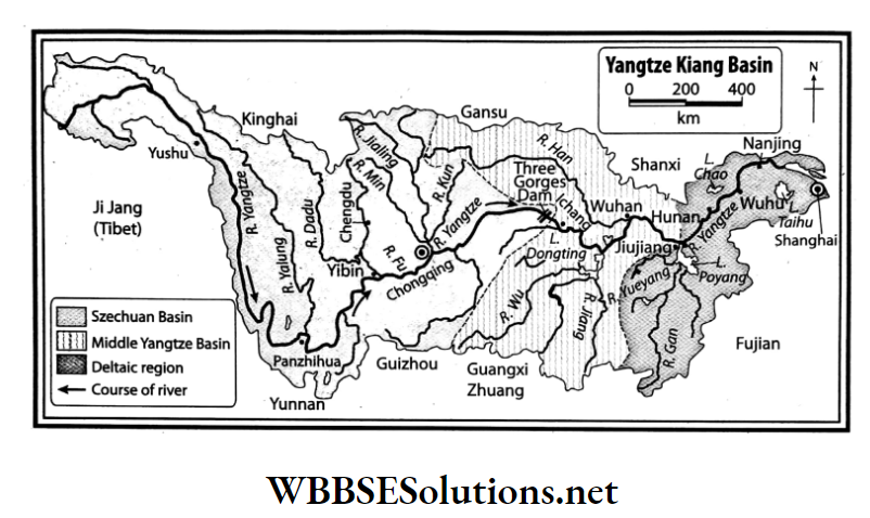
Geographical environment of the Yangtze Kiang Basin:
The Yangtze Kiang Basin can be divided into the following regions from its source to mouth-
Szechuan Basin:
This basin extends from the source of the River Yangtze, Ichang and is surrounded by Szechuan Alps, Tibetan Plateau and Yunnan Plateau. In the Tertiary Age there was a lake here which got filled up and gave rise to this lowland.
This part of the basin is also called the Red Basin due to the presence of red sandstone. The climate of this region is pleasant, it is densely populated and prospers in agriculture.
WBBSE Solutions For Class 7 Geography
Middle Yangtze Basin:
This part of the basin extends from Ichang to Hunan. It consists of a large plain, innumerable lakes and low hills. As this region is composed of new alluvium it is highly suitable for agriculture and is known as the ‘Granary of China’.
Hunan is also called the ‘Rice Bowl of China’ for its considerable production of paddy cultivation. Other crops produced are wheat, cotton, sugarcane, oilseeds etc.
Delta region:
The Yangtze Kiang Delta region extends from Hunan to the China Sea. It is a plain area and intensive agriculture produces loads of crops here. The river forms a huge delta and divides itself into a number of distributaries before draining into the China Sea.
Many places have been reclaimed from the sea and so this delta region is also called the ‘Holland of China’. The Grand Canal which is located here is the longest canal in the world.
Shanghai, the largest city and port of China, is located in this region. This city is known as the ‘Manchester of China’ due to advancement in the textile industry.
Question 2. List the reasons for economic development in the Yangtze Kiang Basin.
Answer:
Reasons for economic development in the Yangtze Kiang Basin:
On the basis of the economy, the most developed region in China is the Yangtze Kiang River Basin. The reasons for the development of this region are-
- The favourable climate, fertile soil and developed irrigation system help in the production of all types of crops in this region. 75% of the country’s paddy production comes from this region, along with 50% production of the other crops. Thus, this region is known as the ‘Granary of China’. The use of modern means of technology and agricultural implements can be noticed here.
- The Yangtze Kiang Basin is one of the most mineral-rich regions in China.
- Different types of industries have grown in this region namely cotton textile, shipbuilding, iron and steel, silk textile, cement, paper, etc.
- Along with the inland waterways rail and road transport is also very developed. Thus import and export of materials through this developed transport network has enhanced the economic development of the region.
- As the Yangtze Kiang Valley is the most densely populated region in China, cheap labour and the market is easily available.
- This region is one of the main tourist areas in China.
Chapter 9 Topic B Yangtze River Basin Of China Short Analytical Type Questions
Question 1. Describe the environmental conditions of the Szechuan Basin.
Answer:
The environmental conditions of the Szechuan Basin:
The Szechuan Basin constitutes the upper course of the Yangtze River which passes through the Szechuan Province. It extends from the source of the Yangtze River to Ichang.
It is mainly a lowland bound by different plateaus and mountains on all sides and has been. formed by the depositions brought down by the four tributaries of the Yangtze River.
The rivers which flow over this basin are Yalung Jiang, Min Jiang, Tuo Jiang, Jialing Jiang, Jinsha Jiang, etc. The climate prevailing over this region is pleasant and due to the predominance of red soil in the region, it is also called Red Basin.
This region prospers in agriculture and is densely populated.
Question 2. What are the reasons for the development of agriculture in the Yangtze Klang Basin?
Answer:
The reasons for the development of agriculture in the Yangtze Klang Basin:
The Yangtze Kiang Basin is one of the most agriculturally developed regions in China. The reasons for the development of agriculture in this region are-
- Plain land formed by the rivers.
- Highly fertile soil
- Favourable climate for cultivation
- Availability of sufficient cheap and skilled labour
- High demand of agricultural products
- Government aids.
Apart from these, high yielding variety of seeds, excellent fertilisers, modern tools and equipment for cultivation, provisions for modern agricultural training, etc are the main reasons for the development of agriculture in the region.
The Yangtze Kiang River basin is the most agriculturally rich region in China. Out of the total agricultural production of China, 70% of wheat and more than 50% of the other crops is produced in this region.
Question 3. Which region is called ‘The Granary of China’ and why? Or, Why is the Hunan Province known as the ‘Rice Bowl of China’?
Answer:
The Granary of China:
The Middle Yangtze Kiang Basin in general or the Hunan Province in particular, the most agriculturally rich region in China, is also the largest geographical region in China.
Favourable topography, moderate temperature and rainfall, fertile soil, dense population and government aid help in the abundant production of different types of crops (wheat, paddy, sugarcane, cotton, pulses, tobacco, oilseeds, etc.) across the river basin.
Out of the total crop productivity in China, 70% is of paddy and more than 50% is of wheat. Apart from these, a huge number of mulberry trees are grown for the breeding of silkworms.
Thus, this agriculturally rich Central or Middle Yangtze Kiang Basin is also known as the ‘Granary of China’.
Question 4. Which region is called ‘The Holland of China’ and why?
Answer:
The Holland of China:
The delta region of the Yangtze Kiang is called the ‘Holland of China’, because, like the northwestern part of Holland (now the Netherlands), the Yangtze Kiang delta region is also a low flat plain and there are a number of polders (tracts of lowlands reclaimed from the sea) in this region.
A large number of canals have been dug out for convenience in irrigation and cheap means of water transport similar to that in Holland.
Although the region is not rich in minerals like that of Holland, it is rich in agriculture and industry and is densely populated.
Chapter 9 Topic B Yangtze River Basin Of China Short Answer Type Questions
Question 1. What are the divisions of the Yangtze Kiang Basin?
Answer:
The divisions of the Yangtze Kiang Basin:
The Yangtze Kiang Basin in China is generally divided into three sub-regions.
They are-
- The Sichuan Basin comprises the upper course of the Yangtze Kiang, under the Sichuan province.
- The Middle Yangtze Basin forming the middle course of the river, from Ichang to Hunan and
- From Hunan to the coast of the China Sea lies the deltaic region formed by the lower course of the Yangtze Kiang.
Question 2. Give an account of the climate and soil of the Sichuan Basin.
Answer:
The climate and soil of the Sichuan Basin:
The climate of the Sichuan Basin is pleasant.
The average temperature during summer is between 27°C-32°C and the average temperature during winter season ranges between 10°C -15°C.
It rains more during the summer season (average rainfall ranges between 100 cm-150 cm). Snowfall occurs occasionally during winter. The colour of the soil in this region is red, so, this region is also known as Red Basin.
Question 3. Which region is called the Rice Bowl of China and why?
Answer:
Rice Bowl of China:
The Central Basin of the Yangtze Kiang is very fertile and the topmost crop-producing region in China.
Due to the prevalence of comparatively hot and wet climate in the Hunan province of the Central Yangtze Basin, large quantities of rice is produced and so the Human province is called the ‘Rice Bowl of China’.
Other than rice, the chief agricultural crops produced in this region are wheat, cotton, mustard, tung oil and tea.
Question 4. Why is Shanghai called the ‘Manchester of China’?
Answer:
Manchester of China:
Sanghai is an important city located in the deltaic region of Yangtze Kiang. It is an important centre for the cotton textile industry. just like Manchester of England. Thus, Shanghai is known as the ‘Manchester of China’.
Question 5. Which region is called the wetland of China?
Answer:
The wetland of China:
The Yangtze Kiang River divides itself into a number of distributaries in its delta region and all of them drain into the China Sea. There are also a number of lakes and lagoons. So this delta region is referred to as the wetland of China.
Question 6. Name three abundant mineral resources of the Yangtze River Basin.
Answer:
Three abundant mineral resources of the Yangtze River Basin are-
- Coal,
- Iron ore,
- Copper.
Chapter 9 Topic B Yangtze River Basin Of China Multiple Choice Questions Choose The Correct Option
Question 1. Yangtze River Basin is-
- The third longest river in the world
- The fourth longest river in the world
- The fifth longest river in the world
Answer: 1. Third longest river in the world
Question 2. Red Basin is located in-
- China
- Japan
- Saudi Arabia
Answer: 1. China
Question 3. Szechuan Basin is red because of-
- Sandstone
- Quartzite
- Claystone
Answer: 1. Sandstone
Question 4. The climate of the Yangtze River Basin is-
- Harsh
- Comfortable
- Fit for habitation.
Answer: 2. Comfortable
Question 5. is called the Rice Bowl of China.
- Shanghai province
- Hunan province
- Middle Yangtze
Answer: 2. Hunan province
Question 6. An important agricultural crop grown in the Yangtze River Basin is
- Coffee
- Rubber
- Paddy
Answer: 3. Paddy
Question 7. province is called the Granary of China.
- Henan
- Hunan
- Guangdong
Answer: 2. Hunan
Question 8. is called Holland of China.
- Yangtze delta
- Szechuan basin
- Middle Yangtze basin
Answer: 1. Yangtze delta
Question 9. Land reclaimed from the sea is called-
- Holter land
- Polder land
- Delta
Answer: 2. Polder land
Question 10. An important mineral resource found in the Yangtze River Basin is-
- Iron Ore
- Cobalt
- Mica
Answer: 1. Iron Ore
Chapter 9 Topic B Yangtze River Basin Of China Very Short Answer Type Questions Fill In The Blanks
Question 1. The Yangtze Kiang of China flows into the _______.
Answer: China Sea
Question 2. The Red Basin extends from the source of the Yangtze to _______.
Answer: Ichang
Question 3. The upper reaches of the Yangtze River Basin is referred to as _______ because of the red colour of its rocks and soil.
Answer: Red Basin
Question 4. The Middle Yangtze Basin region prospers in agriculture due to _______.
Answer: New alluvium
Question 5. The _______ region is known as the Granary of China.
Answer: Middle Yangtze Basin
Question 6. The _______ River Valley is called the cradle of the Chinese civilisation.
Answer: Hwang Ho
Question 7. The largest city of China is _______.
Answer: Shanghai
Question 8. _______ is the prime port of China.
Answer: Shanghai
Question 9. The _______ River Basin is known to produce the world’s best tungsten.
Answer: Yangtze
Write True Or False
Question 1. The Yangtze Kiang Basin has been divided into four parts.
Answer: False
Question 2. The capital of China is Shanghai.
Answer: False
Question 3. The Hunan province of China is known as its Granary.
Answer: True
Question 4. The Yangtze Kiang flows into the Sea of Japan.
Answer: False
Question 5. The upper reaches of the Yangtze Kiang Basin is famous as the ‘Holland of China’.
Answer: False
Question 6. The principal port of the Yangtze Kiang basin is Shanghai.
Answer: True
Question 7. Yangtze Kiang is also known as the ‘Golden Sanded River’.
Answer: True
Question 8. Yangtze Kiang is not only the longest river in China but also in Asia.
Answer: True
Question 9. The Yangtze Kiang is known as Chang-Jiang near its place of origin.
Answer: False
Question 10. Beijing, the capital of China, is situated near the mouth of the Yangtze Kiang.
Answer: False
Question 11. Wuchang is a big city and centre of commerce situated on the Yangtze Kiang Delta.
Answer: False
Question 12. The Yangtze Kiang is the best inland waterway in China.
Answer: True
Question 13. Shanghai is called the ‘Manchester of China’.
Answer: True
Chapter 9 Topic B Yangtze River Basin Of China Match The Columns
1.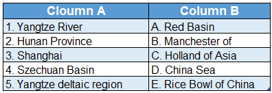
Answer: 1. D, 2. E, 3. B, 4. A, 5. C
Answer In One Or Two Words
Question 1. Which is the longest river in Asia?
Answer: Yangtze.
Question 2. River Yangtze originates from which mountain?
Answer: Kunlun.
Question 3. Which river of Asia is known as ‘The River of Golden Sands’?
Answer: Yangtze Kiang.
Question 4. What name is given to the upper reach of the Yangtze River (Szechuan Basin) because of the red-coloured sandstones found in this region?
Answer: Red Basin.
Question 5. Which place is known as the ‘Rice Bowl of China’?
Answer: Hunan province.
Question 6. Which place is called the ‘Granary of China’?
Hunan province.
Question 7. Which place is called the ‘Holland of China’?
Answer: Yangtze Kiang Delta Region.
Question 8. Name the principal centre of China’s cotton textile industry.
Answer: Shanghai.
Question 9. Which is the longest man-made canal in the world?
Answer: Grand Canal (China).
