WBBSE Solutions For Class 6 Geography Chapter 7 Weather and Climate Topic B Temperature Wind Cloudiness Rainfall

WBBSE Class 6 Geography Chapter 7 Weather And Climate Topic B Temperature Wind Cloudiness Rainfall Long Answer Type Questions

Question 1. Why does temperature vary from one place to the other?
Answer:

The reasons for the variation of temperature at different places are as follows—

Latitude: The Equator receives vertical rays of the Sun, whereas, the Poles receive oblique rays.

The vertical rays are hotter as they are concentrated in a smaller region when compared to the oblique rays, which are spread out over a larger region.

Thus, as we move towards the Poles the temperature decreases.

WBBSE Solutions For Class 6 Geography Chapter 7 Weather and Climate Topic B Temperature Wind Cloudiness Rainfall Temperature variation with latitudes

Distance from the sea: Places located near the sea experience a maritime climate, i.e., neither too hot nor too cold.

Whereas, the further we move away from the sea, the areas start experiencing extreme climates very hot during summers and very cold during winters.

Length of the days: Summers are hotter because of longer days and shorter nights. Conversely, winters are colder due to shorter days and longer nights.

Altitude: With every 1000 m rise in altitude, the temperature falls by 6.5°C. Darjeeling is colder than Siliguri because of this reason.

WBBSE Solutions For Class 6 Geography Chapter 7 Weather and Climate Topic B Temperature Wind Cloudiness Rainfall Temperature variation with altitude

Other factors: The other factors are—

  1. Amount of rainfall received,
  2. Physical characteristics of a region,
  3. Ocean currents,
  4. Type of soil,
  5. Cloud cover,
  6. Forest cover and
  7. Human activities.

WBBSE Solutions For Class 6 Geography Chapter 7 Weather and Climate Topic B Temperature Wind Cloudiness Rainfall

Read And Learn More WBBSE Solutions For Class 6 Geography

Question 2. What are Heat belts? Divide the Earth into various Heat zones or belts and discuss any one briefly.
Answer:

Heat belts:

The divisions of the Earth on the basis of the amount of heat received by different regions are called Heat zones or belts.

The variation of heat occurs as the equatorial region receives vertical rays of the Sun, whereas the polar regions receive oblique rays.

So, the Earth has divided into five heat zones a torrid zone, two temperate zones and two frigid zones, according to their temperature variation.

WBBSE Solutions For Class 6 Geography WBBSE Solutions For Class 6 History WBBSE Solutions For Class 6 Maths
WBBSE Class 6 Geography Notes WBBSE Class 6 History Notes
WBBSE Class 6 Geography Multiple Choice Questions WBBSE Class 6 History MCQs WBBSE Notes For Class 6 School Science


WBBSE Class 6 Weather Elements Notes

Torrid zone: This zone receives vertical sun rays throughout the year.

Location: From the Equator (0°) to the Tropic of Cancer (23°C-35°C) in the North and to the Tropic of Capricorn (23%°) in the South. Countries in this zone are — Brazil, Chile, Nigeria, Kenya, Ghana, Malaysia, Indonesia, India etc.

Characteristics: The main characteristics of this zone are—

Since this region receives vertical rays of the Sun all year, high temperature (25°C-35°C) prevails. Since most of the waterbodies also lie in this region, the humidity is also very high (7596-9096).

Equatorial evergreen trees (Mahogany, Redwood, Ironwood) and deciduous trees (Sal, Teak, Bamboo, Sandalwood) are the main flora.

Carnivorous and herbivorous mammals and reptiles thrive here. E.g.—chimpanzee, gorilla, orangutan, crocodile, elephant and cheetah.

Question 3. How does climate affect the people of a region?
Answer:

Climate affect the people of a region:

The climate of a region has a great impact on the lives of the people of that region.

The food they eat, the homes they live in, the clothes they wear to their livelihoods – everything is influenced by the climate.

Agriculture: Depending on the climate of a region, the agricultural activities of the place
flourish.

India has a tropical monsoon climate, which receives an ample amount of rain during monsoons. This in turn is beneficial for the cultivation of a number of crops.

Housing: The houses we live in are greatly affected by the weather. In regions of heavy rainfall like the equatorial region,

The roofs are slanting. In cold regions, houses are made of stone to prevent the freezing outside temperature from entering the house.

Food: The food habits of people depend greatly on the region they live in. People living in temperate zones eat cereals and pulses as farming is possible in these regions.

But in the frigid zone, since farming is not possible, food is obtained by hunting and gathering.

Clothes: In hot regions, people wear loose, flowy clothes made of cotton while in colder regions, people wear clothes made of animal fur and hide for better protection from the cold.

Livelihood: In equatorial regions, native people are hunter-gatherers and also carry out subsistence farming.

Farming is extensively done in and around the tropics. Towards the poles, the cold climate restricts farming activities and people rely on fishing and hunting again.

From the above, we can conclude that the climate of a region affects the way of life greatly.

Question 4. Write a brief note on the anemometer.
Answer:

Anemometer:

An anemometer is an instrument used to measure the speed of the wind. The term is derived from the Greek word for wind – ‘anemos’.

A simple anemometer is made up of four hemispherical cups, each mounted on one end of the four horizontal arms. These arms in turn are mounted at equal angles from each other on a vertical shaft.

The airflow past the cups in any horizontal direction turns the shaft in a manner that is proportional to the wind speed.

Therefore one has to count the number of times the reference cup makes a complete revolution around the axis in a given time period.

This has to be multiplied by the distance travelled by the reference cup in one revolution.

WBBSE Solutions For Class 6 Geography Chapter 7 Weather and Climate Topic B Temperature Wind Cloudiness Rainfall Temperature Anemometer

Thus, we get speed On an Anemometer with four cups, it is easy to understand that since the cups are arranged symmetrically on the end of the arms, the wind always has the hollow of one cup turned towards it and is blowing on the back of the cup on the opposite end of the cross.

Short Questions on Wind and Rainfall

Question 5. Write about the instrument used to measure atmospheric pressure.
Answer:

The instrument used to measure atmospheric pressure:

The instrument i.e. used to measure atmospheric pressure is known as Barometer. This instrument was invented by Toricelli in the year 1643.

While there are many kinds of Barometers in common use, one of special importance is Fortin’s Barometer.

WBBSE Solutions For Class 6 Geography Chapter 7 Weather and Climate Topic B Temperature Wind Cloudiness Rainfall Fortin,s barometer

The tube containing the mercury is itself enclosed in a brass tube, the upper part of which is made of glass so that the mercury can be seen.

The pressure is read by moving a millimetre scale alongside a vernier scale. The zero of the scale is at the tip of an ivory pointer fixed to the lower end of the brass tube.

The mercury reservoir is a leather bag which can be raised or lowered by a screw.

Question 6. Write about a wind vane or weather-cock.
Answer:

A wind vane or weather-cock:

A wind vane or weather-cock is an instrument used to determine the direction of the wind.

The simplest design is in the shape of an arrow with the points of the compass marked below it.

A popular design is that with a cockerel at the top. This instrument is also used as an ornamental architectural feature on top of buildings.

The construction of wind vanes has to be very precise so that they respond to even the slightest change in wind direction. A wind vane spins and points in the direction from which the wind is blowing.

WBBSE Solutions For Class 6 Geography Chapter 7 Weather and Climate Topic B Temperature Wind Cloudiness Rainfall Temperature wind vane

Question 7. What are the different measures of cloud cover?
Answer:

The different measures of cloud cover:

The fraction of sky obscured by a cloud is called the cloud cover. This can be measured as—

  1. 0% cloud cover which means a clear sky.
  2. 25% cloud cover which means 25% of the sky is covered by clouds or it is a partly cloudy sky.
  3. 75% cloud cover which means it is a cloudy sky.
  4. 100% cloud cover which means it is an overcast sky.

WBBSE Solutions For Class 6 Geography Chapter 7 Weather and Climate Topic B Temperature Wind Cloudiness Rainfall Temperature clound cover

Common Questions About Cloudiness and Weather

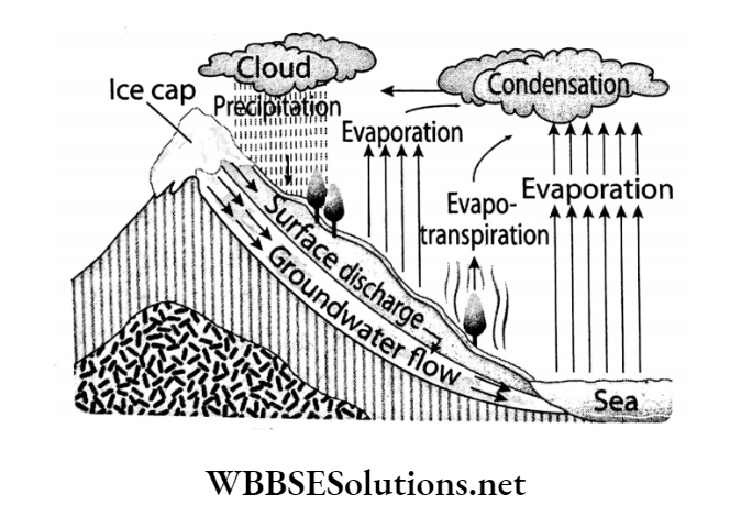
Question 8. How does rainfall occur?
Answer:

Rainfall occur:

Condensation takes place when the water vapour in the air changes into a liquid state.


WBBSE Solutions For Class 6 Geography Chapter 7 Weather and Climate Topic B Temperature Wind Cloudiness Rainfall Formation of rain

Moisture-laden air rises up when heated. As warm air rises and eventually cools, it forms water droplets.

The condensed droplets of water attract additional water vapour from the surrounding air which gathers around dust particles.

Rainfall occurs when these droplets become too heavy to remain suspended in the air and come down because of the gravitational pull.

Question 9. Write a brief note on the rain gauge.
Answer:

Rain gauge:

Usually, about 1/8 of the rainwater falling on a particular place evaporates, 1/4 gets absorbed in the soil and some flows as surface run-off due to the slope of the land.

But when rainwater is collected in a vessel with unit divisions marked, it shows the exact amount of rainfall received at that place.

Rain gauge is an instrument used to measure the amount of rainfall received at a particular place in a given period of time.

WBBSE Solutions For Class 6 Geography Chapter 7 Weather and Climate Topic B Temperature Wind Cloudiness Rainfall Rain gauge

The Rain gauge is a tubular instrument with a radius of 20cm and a height of 50cm with a funnel of 2 cm radius at its mouth inserted inside a glass bottle within the cylinder.

There is also a measuring jar with graduations kept beside it. Every three hours, the amount of rainfall collected in the glass bottle through the funnel is poured out into the measuring jar and recorded.

Practice Questions on Wind Speed and Direction

Question 10. Though the sky is full of clouds, all clouds do not cause rainfall. Explain why.
Answer:

Though the sky is full of clouds, all clouds do not cause rainfall

Water vapour formed from the surface of heated ponds, lakes, rivers, seas and oceans rises up and then comes into contact with the cooler layers of the atmosphere.

The water vapour then condenses into droplets of water or flakes of snow around particles of dust, sand, salt among others which are suspended in the atmosphere.

Collectively, these droplets of water and snowflakes form clouds. Generally, these droplets of water are about 0.01mm in radius and so they can keep floating in the air as clouds.

But once they start growing larger and reach a size of about 0.05 mm radius, they become too heavy and thus fall on Earth as rain or snow.

So, while all clouds are composed of water droplets or snowflakes, all clouds do not cause rainfall or snowfall.

Question 11. In India, how is insolation in summer different from insolation in winter? Or, Is the sunshine different in summer and in winter?
Answer:

The sunshine different in summer and in winter:

The Earth rotates around a tilted axis. So, all the places on Earth do not receive the same amount of solar insolation.

India is located in the Northern Hemisphere and thus receives vertical sun rays during summer.

Hence we experience hot summers with scorching Sun. In winter, the Sun’s vertical rays fall on the Southern Hemisphere and we in India receive oblique rays.

So, the winter Sun feels milder as the insolation received is less intense in the Northern Hemisphere.

Question 12. Why does air temperature fall with rising altitude?
Answer:

Air temperature falls at a rate of 6.5°Cwith every 1000 metre rise in altitude. This is because of the following reasons—

The heat radiated back from the Earth’s surface hardly warms up the upper layers of the atmosphere. Thus the temperature remains low and gradually falls with a rise in altitude.

The upper layers of the atmosphere are rarer than the lower layers, resulting in more efficient radiation of heat and faster cooling down.

The upper atmospheric layers contain lesser water vapour and dust particles. So, these layers absorb less heat and remain cooler.

WB Class 6 Geography Question Answer

Question 13. The temperature of a place located at ‘A’ is 16°C. The temperature of place ‘B’ located at sea level is 20°C. Find out the difference in altitude between places ‘A’ and ‘B’.
Answer:

The temperature of a place located at ‘A’ is 16°C. The temperature of place ‘B’ located at sea level is 20°C.

The temperature difference between places ‘A’ and ‘B’ is (20-16)°C = 4°C. The temperature of place ’B’ is higher since ‘B’ is located at sea level.

We know, Temperature falls by 6.5°C with a rise in altitude of 1000 m.

Therefore, the temperature will fall by 1°C with a rise in altitude of 1000/ 6.5 = 153.8 m (approx 154m)

Hence, the temperature will fall by 4°C with a rise in altitude of 154 x 4 = 616m.

Therefore, it can be concluded that ‘A’ is located at an altitude of 616m higher than ‘B’.

Question 14. Write about the torrid zone.
Answer:

Torrid Zone:

Torrid zone: This zone receives vertical sun rays throughout the year.

Location: From the Equator (0°) to the Tropic of Cancer (2334°) in the North and to the Tropic of Capricorn (231/z°) in the South.

Countries in this zone are — Brazil, Chile, Nigeria, Kenya, Ghana, Malaysia, Indonesia, India etc.

Characteristics: The main characteristics of this zone are— O Since this region receives vertical cays of the Sun all year, high temperature (25°C- 35°C) prevails.

Since most of the waterbodies also lie in this region, the humidity is also very high (75%-90%).

Equatorial evergreen trees (Mahogany, Redwood, Ironwood) and deciduous trees (Sal, Teak, Bamboo, Sandalwood) are the main flora.

Carnivorous and herbivorous mammals and reptiles thrive here. E.g.—chimpanzee, gorilla, orangutan, crocodile, elephant and cheetah.

Question 15. Write about the temperate zone.
Answer:

Temperate zone: This zone receives slanting rays throughout the year.

Location: From the tropics (231/4°N and S) to the Arctic and Antarctic Circles (66/2° N and S).

Some countries in this zone are—

The United States of America, Chile, France, South Africa, New Zealand, England, Canada, Japan, Germany, Italy, etc.

Characteristics: The main characteristics of this zone are—

Since this region receives slanting rays of the Sun all year, moderate temperature (10°C to -10°C) prevails.

The regions near the tropics have higher temperatures and the ones near the poles have cooler temperatures.

Coniferous trees and Steppe Grasslands are common in this region.

Several migratory birds and carnivorous and herbivorous animals (like bison and bears) are seen in this region.

WB Class 6 Geography Question Answer

Question 16. Write about the frigid
Answer:

Frigid zone: This region receives extremely oblique rays throughout the year.

Location: From the Arctic and Antarctic Circle (6634°N and S) to the Poles (90°N and S).

Some countries and continents of this zone are—

Antarctica, Siberia of Russia, Alaska of USA, Greenland, Northern Canada, Norway, and northern parts of Sweden.

Characteristics: The main characteristics of this region are—

This region receives extremely oblique rays of the Sun all year, so the temperature remains below freezing point (0°C) and in some places almost -40°C.

The temperature in the Northern Hemisphere is relatively lesser than that of the Southern Hemisphere because of the greater area extent of the landmass in the former.

Flora found here is mostly mosses, lichens, grasses, and berry-bearing shrubs.

Animals that are found here have adapted to the frigid climate like reindeer, caribou, musk ox, polar bear, arctic fox, seals, penguins, sea otters and many species of whales.

WBBSE Solutions For Class 6 Geography Chapter 7 Weather and Climate Topic B Temperature Wind Cloudiness Rainfall Heat zones

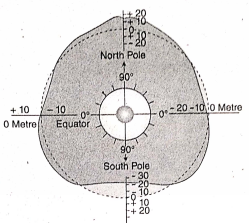
Question 17. What are the special characteristics of isotherms?
Answer:

Isotherms are imaginary lines that connect all points on a map with the same temperature.

Their special characteristics are as follows:

Isotherms are usually parallel to lines of latitude. This is because it is the latitude of a place that determines its temperature spaced.

If the difference in temperature is more between two places, and if the difference in temperature is less, the isotherms are spaced far apart.

The isotherms in the Southern Hemisphere are further away from each other than in the Northern Hemisphere as there are more waterbodies in the former. Isotherms never touch or intersect with each other.

WBBSE Solutions For Class 6 Geography Chapter 7 Weather and Climate Topic B Temperature Wind Cloudiness Rainfall isotherms

Question 18. What do you know about Temperature inversion?
Answer: The reversal of the usual behavior of temperature is known as the phenomenon of temperature inversion.

Usually, with an increase in altitude, the temperature decreases. But sometimes, the reverse event takes place- temperature increases in direct proportion to the increase in altitude.

On clear nights, the ground cools rapidly because of radiation.

A temperature inversion starts to develop when the air above the ground is cooled by contact with a colder surface till it becomes cooler than the overlying atmosphere.

The topography also greatly affects the magnitude of temperature inversions.

In hilly areas, the cold air from the top of the mountains tends to flow into the valleys, producing a greater inversion of temperature.

The low-lying valleys become colder than the mountain tops.

Question 19. Fill in the knowledge hive with information on isotherms.

WBBSE Solutions For Class 6 Geography Chapter 7 Weather and Climate Topic B Temperature Wind Cloudiness Rainfall knowledge hive

Answer:

1. They are imaginary lines drawn on Earth joining places with the same temperature.

2. Whether on land or sea, these are always parallel.

3. They are usually parallel to the lines of latitude.

4. Isotherms are closely spaced if the difference in temperature between two places is more.

5. If the difference in temperature between two places is less, the isotherms are placed far apart.

Question 20. The given illustration shows the relation between the increase in altitude and the decrease in temperature. Note down the temperatures at the marked numbered places.

WBBSE Solutions For Class 6 Geography Chapter 7 Weather and Climate Topic B Temperature Wind Cloudiness Rainfall temperature altitude

Answer:

1. 20°C – 6.5°C = 13.5°C
2. 13.5°C – 6.5°C = 7°C
3. 7°C – 6.5°C = 0.5°C
4. 0.5°C – 6.5°C = -6°C

Question 21. Crossword

WBBSE Solutions For Class 6 Geography Chapter 7 Weather and Climate Topic B Temperature Wind Cloudiness Rainfall Cross word

Clues:________________________

Down:

1. Average weather conditions of a region over an extended period of time.
2. Used to measure atmospheric pressure.
3. Headquarters of West Bengal weather department.
4. Average temperature is least in this zone.

Across:

5. The Earth’s gravity holds this in place.
6. This season prevails in India from December to February.

Answer: Down:_____________

1. Climate,
2. Barometer,
3. Alipore,
4. Frigid

Across:_____________

5. Atmosphere,
6. Winter

Question 22. Divide your class into 5 teams. Now select an identity from the following for each of these teams.

  1. Farmer
  2. Student
  3. Fisherman
  4. Pilot
  5. Captain of a ship

How useful are weather forecasts in your everyday life — Discuss the issue among yourselves, keeping in mind the selected identities.

Answer:

WBBSE Solutions For Class 6 Geography Chapter 7 Weather and Climate Topic B Temperature Wind Cloudiness usefulness of weather forecat in everyday life

Aesthetics and Creativity: This segment will check the aesthetic sense and creativity of the students.

Question 23. Write a report on the influence of climate on our lives.
Answer:

Impact of Climate on Human Life

Satadru Banerjee, Kolkata
-29, March 2020

The role of climate in human life is immense. The climate of different regions of the world has brought various changes in human life in those regions.

Climate affects food, clothing, shelter, livelihood, occupation, etc. The people of monsoon climate consume rice, people of temperate zones consume bread,

Tribes of equatorial areas eat wild fruits and hunt animals and people of cold climates consume sea fish as food due to climatic differences.

The people of the tropics wear light cotton clothes, while the people of temperate regions use wool and leather for clothing.

The people of the frigid zone live in houses made of ice, houses with sloping roofs are common in areas of heavy rainfall.

Again, in areas of heavy rainfall, people farm and develop industries. The main occupations in the equatorial regions are the collection of fruits, livestock rearing, hunting,

whereas animal hunting and fishing are the primary occupations in cold climatic areas.

The culture, language, manners and energy level of people differs from one climatic region to another. So the impact of climate on human life is undeniable.

WBBSE Chapter 7 Weather And Climate Topic B Temperature Wind Cloudiness Rainfall Short Answer Type Questions

Important Definitions Related to Weather Elements

Question 1. What is meant by atmospheric pressure?
Answer:

Atmospheric pressure:

The pressure exerted by the air on the Earth’s surface is known as atmospheric pressure. This is measured with the help of an instrument known as Fortin’s Barometer.

The atmospheric pressure at sea level is about 1013.25 millibar.

Question 2. What do we mean by ‘high pressure’ and ‘low pressure’?
Answer:

‘High pressure’ and ‘low pressure’:

At any place, if a Barometer reads the air pressure of more than 1013.25mb, the area is experiencing high pressure.

Conversely, if the Barometer reads less than 1013.25 mb, the area is experiencing low pressure.

Pressure falls if the prevailing winds are warm and humid and it rises if the winds are cold and dry. High pressure characterises clear skies and calm weather while stormy weather indicates low pressure.

Question 3. What is the relation between atmospheric pressure and wind direction?
Answer:

The relation between atmospheric pressure and wind direction:

There is a significant correlation between atmospheric pressure and wind direction. Wind always flows from a high-pressure zone to a low-pressure zone.

The greater the difference in pressure, the higher will be the speed of the wind.

Question 4. Which window would you like to close on a winter morning?
Answer:

In India, we prefer to shut the windows facing north during winter mornings.

This is because India is under the influence of the cold and dry winds blowing from the north during winter. The intensity of cold increases under the influence of these winds.

Question 5. What is meant by cloud cover or cloudiness?
Answer:

Cloud cover or cloudiness:

The measurable proportion of clouds in the sky is called cloud cover. Cloud cover may range from 0% (clear sky) in the winter to 100% (overcast) during the rainy season.

Question 6. Why do we feel warmer on a cloudy night? Or, Why is a cloudy night often hot and sultry?
Answer:

The Earth’s surface absorbs only about 51% of the insolation. At night, the Earth radiates this heat back to the atmosphere.

A cloudy sky acts as a reflector and prevents the heat from escaping. So, the heat is trapped within the atmosphere and we feel warmer on cloudy nights.

Question 7. How do cloudy days affect the temperature of that day?
Answer:

A cloudy sky restricts the incoming solar radiation. This results in a cooler day. At night, if the cloudiness prevails, then the insolation received during the day cannot escape, resulting in a warmer night.

On the contrary, if the night sky becomes cloud-free then the temperature becomes cooler than the day, as the insolation is radiated back.

Examples of Different Types of Rainfall

Question 8. What is meant by condensation?
Answer:

Condensation:

The moisture-laden air being light moves upwards. The temperature and air above are less and thus the moisture cools down and turns into little droplets of water.

This is the process of condensation. Condensation takes place when the water vapour in the air changes into a liquid form that is, a change of state from gas to liquid. This is the reverse process of evaporation.

Question 9. What is rainfall?
Answer:

Rainfall:

As water from rivers, seas and oceans evaporates and becomes water vapour, the moisture-laden air rises up into the cooler layers of the atmosphere.

The water vapour then condenses around dust particles to form tiny droplets of water which collectively form a cloud. When the droplets become too heavy to float, they start falling down as a result of the Earth’s gravity.

This process by which condensed water vapour falls down to Earth in the form of drops of water is called rainfall.

Question 10. How does snowfall occur?
Answer:

Snowfall occur:

Snow forms in clouds when the temperature goes below freezing point (0°C or 32°F) and water vapour in the atmosphere condenses directly into ice without undergoing the liquid stage.

Once an ice crystal is formed, it attracts additional water vapour from the surrounding air, growing into a snow crystal, which then comes down to the Earth as snowfall.

Question 11. What is meant by weather forecast?
Answer:

Weather forecast:

A weather forecast is a predicted statement of the condition the elements of weather are likely to be in for the next day or the next few days.

Meteorologists (scientists who study weather and climate) use satellite images, their own observations and their knowledge of trends and patterns of the condition of weather elements to forecasting the weather.

By using these methods, reasonably accurate forecasts can be made up to seven days in advance.

Question 12. What is monsoon wind?
Answer:

Monsoon wind:

The term ‘monsoon’ means a seasonal shift in the prevailing wind direction, that usually brings with it a different kind of weather.

Monsoon winds always blow from cool to warm regions i.e., from areas of high pressure towards areas of low pressure.

For instance, the summer monsoon winds and the winter monsoon winds determine the climate for most of India and Southeast Asia.

WBBSE Class 6 Geography Question Answer

Question 13. What Is meant by the angle of incidence of sunlight on Earth?
Answer:

The angle of incidence of sunlight on Earth:

The angle at which sunlight strikes the Earth’s surface is called the angle of incidence of sunlight on Earth.

Since the Earth is tilted at an angle of 6634° towards its orbital plane, the angle of incidence is different at different places.

It is warmer where the Sun’s rays fall vertically i.e. at the equator and colder where the rays are oblique.

Question 14. What is meant by the normal lapse rate?
Answer:

The normal lapse rate:

The normal lapse rate is defined as the rate at which atmospheric temperature decreases with an increase in altitude.

This is highly variable as it is dependent on weather conditions but generally, it is considered to be a decrease of 6.5°C for every 1 km.

Question 15. What is an isotherm?
Answer:

Isotherm:

Isotherm is an imaginary line that connects all points with equal temperature on a map. Isotherms are very useful in giving an idea of temperature and weather patterns.

Question 16. What are the heat belts?
Answer:

Heat belts:

The divisions of the Earth into three belts on the basis of the amount of heat received by different regions are called heat belts.

The Earth is divided into one torrid zone, two temperate zones and two frigid zones in both hemispheres.

Question 17. In some places, it is cold throughout the year. Explain why.
Answer:

Many places on Earth are cold throughout the year.

This is because of the following reasons—

  1. If the region is at or near the poles, it receives only oblique rays of the Sun all year.
  2. As a result, it receives less heat. For instance, Antarctica is always frozen.

Again, if the place is located at a high altitude, the layer of air at that altitude is cold following the rule of decreasing temperature with increasing altitude. For instance, Darjeeling is always colder than Kolkata.

Question 18. If it is cloudy during the day, will the temperature rise or fall during the day? Or, If there is no cloud on a winter day, wilt the temperature at night rise or fall?
Answer:

If it is cloudy during the day, the incoming solar radiation is unable to reach the Earth’s surface. The temperature is thus comparatively low during the day.

If there is no cloud cover on a winter day, terrestrial radiation would escape back unhindered. Thus, the temperature at night would fall rapidly.

Question 19. Why do mountaineers carry oxygen cylinders?
Answer: The atmospheric pressure is highest at the sea level and it decreases with an increase in altitude. With the decrease in atmospheric pressure, the amount of oxygen in the air also decreases.

This causes problems in normal breathing at high altitudes. Thus in mountainous areas, the air becomes rarer and rarer

The air pressure becomes very low and the amount of oxygen in the atmosphere is too less that causing breathing trouble.

So, mountaineers have to carry oxygen cylinders to be able to breathe normally.

WBBSE Chapter 7 Weather And Climate Topic B Temperature Wind Cloudiness Rainfall Very Short Answer Type Questions

Question 1. What happens to the atmospheric pressure of a place when its temperature increases?
Answer: The atmospheric pressure decreases.

Question 2. What happens when the air at a place gets heated and moves upwards?
Answer: Low pressure is created.

Question 3. Which instrument is used to measure atmospheric pressure?
Answer: Fortin’s Barometer.

Question 4. What is the name given to the air that moves parallel to the land surface?
Answer: Wind.

Question 5. In which direction do winds blow?
Answer: Winds blow from high-pressure zones to low-pressure zones.

Question 6. Which instrument is used to measure wind speed?
Answer: Anemometer.

Question 7. Which instrument is used to measure wind direction?
Answer: Wind vane.

Question 8. What happens to atmospheric pressure in winter?
Answer: Atmospheric pressure increases.

Question 9. From which direction does the wind blow over West Bengal in winter?
Answer: North.

Question 10. What is the measurement of the cloud-obscured sky at any specific place at a specific time called?
Answer: Cloud cover.

Real-Life Scenarios Involving Weather Changes

Question 11. What is formed from condensed water vapour?
Answer: Water droplets.

Question 12. Which unit is used to measure rainfall?
Answer: Centimetre or Millimetre.

Question 13. Which instrument is used to measure rainfall?
Answer: Rain gauge.

Question 14 What changes are observed in temperature with increasing altitude from sea level?
Answer: Temperature decreases.

Question 15. The temperature is highest in which region of the Earth?
Answer: Tropical region.

Question 16. Where do the Sun’s rays fall vertically and where do they fall obliquely?
Answer: The Sun’s rays fall vertically on the Equator and obliquely at the Poles.

Question 1. Radiation: Conduction: Convection: Albedc
Answer: Albedo(not a process of heat transfer

Question 2. Rainfall: Snowfall: Dew: Fog
Answer: Fog (not a form of precipitation)

Question 3. Thermometer: Anemometer: Barometer Spectrometer
Answer: Spectrometer (not an instrument to measure the elements of weather)

Question 4. Torrid zone: Hydrosphere: Temperate zone: Frigid zone
Answer: Hydrosphere (not a heat belt)

Question 5. Temperature: Humidity: Stream flow: Atmospheric pressure
Answer: Stream flow (not an element of weather)

Question 1. The weather of a place may change after many years.
Answer: During the same

Question 2. Temperature is the transfer of thermal energy.
Answer: Heat

Question 3. Celsius and Sjx are the two units of temperature.
Answer: Fahrenheit

Question 4. Wind vans are used to measure the speed of the wind.
Answer: Direction

Question 5. The headquarter of the Meteorological Department of West Bengal is located in Barasat
Answer: Alipore

Question 1. I am an instrument and with my help, the on isotherm. amount of rainfall is measured. Who am I?
Answer: Rain Gauge

Question 2. I am a blanket of gases that envelopes the Earth. Who am I?
Answer: Atmosphere

Question 3. invented the Barometer. Who am I?
Answer: Toricelli

Question 4. I am the unit used to measure atmospheric pressure. Who am I?
Answer: Millibar

Question 5. I am a region extending from the Equator to 23½° N and S lines of latitude with high temperatures throughout the year. Who am I?
Answer: Torrid Zone

Question 6. I am an imaginary line joining areas with equal temperatures on the Earth’s surface. Who am I?
Answer: Isotherm

WBBSE Chapter 7 Weather And Climate Topic B Temperature Wind Cloudiness Rainfall Scrambled Words

Arrange the jumbled Words:

Question 1. The average weather conditions of 30 to 35 years- 1 MATECLI
Answer: Climate

Question 2. The state of the atmosphere which changes frequently and rapidly— THERWEA
Answer: Weather

Question 3. The instrument to measure rainfall—
Answer: Rain Gauge

Question 4. The part of solar energy reflected back to space without directly heating the Earth’s atmosphere— BEALDOJ
Answer: Albedo

Question 5. The measurable proportion of clouds in the sky— OUDCOCLVER
Answer: Cloud Cover

WBBSE Chapter 7 Weather And Climate Topic B Temperature Wind Cloudiness Rainfall Formative

Participation: This segment will indicate how much the students have actively participated and taken initiative during the class.

Question 1. Put the sign WBBSE Solutions For Class 6 Geography Chapter 7 Weather and Climate Topic B Temperature Wind Cloudiness Rainfall Colud beside sentences concerning weather and the sign WBBSE Solutions For Class 6 Geography Chapter 7 Weather and Climate Topic B Temperature Wind Cloudiness Rainfall Arrow beside sentences concerning the climate.

Question 1. It is cold throughout the year in Darjeeling.
Answer:

 WBBSE Solutions For Class 6 Geography Chapter 7 Weather and Climate Topic B Temperature Wind Cloudiness Rainfall Arrow

Question 2. There are chances of wind blowing at a speed of 60 km in the forthcoming 48 hours.
Answer: 

WBBSE Solutions For Class 6 Geography Chapter 7 Weather and Climate Topic B Temperature Wind Cloudiness Rainfall Colud

Question 3. There has been very little rainfall over the Sahara Desert for many years.
Answer:

 WBBSE Solutions For Class 6 Geography Chapter 7 Weather and Climate Topic B Temperature Wind Cloudiness Rainfall Arrow

Question 4. There has been 20 mm of rainfall in Kolkata in the past 24 hours.
Answer:

WBBSE Solutions For Class 6 Geography Chapter 7 Weather and Climate Topic B Temperature Wind Cloudiness Rainfall Colud

Question 5. The temperature in Ladakh often falls down to 40 °C in winter.
Answer:

 WBBSE Solutions For Class 6 Geography Chapter 7 Weather and Climate Topic B Temperature Wind Cloudiness Rainfall Arrow

Question 2. You started off from an altitude of 2000m, where the temperature is 15°C. What will be the temperature at 4000m?
Answer:

The difference in altitude of the two places is (4000-2000)m = 2000m We know, With a 1000m rise in altitude, the temperature falls by 6.5°C

Therefore, with a 2000 m rise in altitude, the temperature will fall by (6.5 x 2)°C= 13°C At 2000m temperature is 15°C Therefore, at 4000m, the temperature would be (15°- 13)°C = 2°C

Interpretation and Application: This segment will test whether the students have understood the topics, or whether they are just memorising them.

Question 1. When Rafiq went out of his house at 9 in the morning, the sky was clear and there was sunshine. At 3 o’clock the sky turned cloudy. On his way back home at 4 o’clock, it had just started raining and the wind picked up.
Answer:

WBBSE Solutions For Class 6 Geography Chapter 7 Weather and Climate Topic B Temperature Wind Cloudiness Rainfall suhine cloudy and raining

Write down how the weather was in the past three days.

WBBSE Solutions For Class 6 Geography Chapter 7 Weather and Climate Topic B Temperature Wind Cloudiness Rainfall The state of weather

Question 2. The maximum and minimum temperatures recorded at two weather stations in a single day are given below:

WBBSE Solutions For Class 6 Geography Chapter 7 Weather and Climate Topic B Temperature Wind Cloudiness Rainfall maximum and minimum temperatures

Note-Even though the average temperature of the two stations is the same, there is a difference in the ranges of temperature. Which station do you think is closer to the sea?

Answer: The average temperature of station A is 25°C. The average temperature of station B is also 25°C. The range of temperature at station A is (36°C – 14°C) 22°C.

On the other hand, the range of temperature at station B is 2°C (26°C – 24°C).

As far as the range of temperature is concerned, it can be concluded that station B is closer to the sea than station A.

Places near the sea experience a minimum range of temperature as in the case of station B.

Question 3. Young weather reporters have to prepare two weather reports. (You will get information about temperature and rainfall from television or radio. Collect the rest of the information by recording your own observations.)
Answer:

Question 1. The month of May (The weather report of seven successive days)

WBBSE Solutions For Class 6 Geography Chapter 7 Weather and Climate Topic B Temperature Wind Cloudiness Rainfall the weather part of seven successive days

Which were the days in which the minimum temperature was highest and lowest?
Calculate the average temperature of each day.

WBBSE Solutions For Class 6 Geography Chapter 7 Weather and Climate Topic B Temperature Wind Cloudiness Rainfall the weather report of seven succesive days.2

WBBSE Solutions For Class 6 Geography Chapter 7 Weather and Climate Topic B Temperature Wind Cloudiness Rainfall the weather report of seven succesive days tble

The minimum temperature was highest on the 6th day, 31°C and was lowest on the 7th day, 27°C.

The table of average temperature for each day is given below:

WBBSE Solutions For Class 6 Geography Chapter 7 Weather and Climate Topic B Temperature Wind Cloudiness Rainfall average temperature

Question 2. The month of September (The weather report of seven successive days)

WBBSE Solutions For Class 6 Geography Chapter 7 Weather and Climate Topic B Temperature Wind Cloudiness Rainfall two weather reports

Which were the days in which the maximum temperature was highest and lowest? Calculate the average temperature of each day.

Answer:

The month of May (The weather report of seven successive days)

WBBSE Solutions For Class 6 Geography Chapter 7 Weather and Climate Topic B Temperature Wind Cloudiness Rainfall the weather report of seven succesive days table

During September, the maximum temperature was the highest, on the 7th day, at 31°C and the lowest on the 4th day, 29°C.

The table of average temperature for each day is given below:

WBBSE Solutions For Class 6 Geography Chapter 7 Weather and Climate Topic B Temperature Wind Cloudiness Rainfall average temperature2

Question 4. Find out the differences in the elements of weather in these reports and write them down in your notebook.
Answer:

The differences in the elements of weather in these two reports of two different months (May and September) are as follows—

Temperature: The month of May is warmer than the month of September.

Rainfall: The amount of rainfall is higher in September than in May. Light to medium amount of rainfall generally occurs in September.

Cloudiness: Sky in the month of May remains partly cloudy.

So rainfall is occasional. On the contrary, the sky in September ranges from almost overcast to overcast. So rainfall is quite frequent.

Wind: Pleasant wind blows from the south in the month of May, often accompanied by thunderstorms.

On the other hand, rainfall due to the southwest monsoon is a general phenomenon in September.

Empathy and Cooperation: This segment will determine the ability of students to cooperate and help others within a group.

WBBSE Class 6 Geography Chapter 7 Weather And Climate Topic B Temperature Wind Cloudiness Rainfall Fill in the Blanks

Question 1. ____________is used to measure the atmospheric pressure of any place.
Answer: Froths barometer

Question 2. Air that moves parallel to the Earth’s surface is called ____________
Answer: Wind

Question 3. ____________winds blow in winter in the northern hemisphere.
Answer: North

Question 4. In the desert of Rajasthan,____________ the average temperature during the day is about
Answer: 48ºC

Question 5. In Leh, the winter temperature is about____________
Answer: -40ºC

Question 6. The fraction of sky obscured by a cloud is called ____________
Answer: Cloud

Question 7. is the instrument to measure ____________ rainfall.
Answer: Rain gauge

Question 8. The normal lapse rate is____________ Torrid zone receives
Answer: 6.5ºC/1000m

Question 9. Torrid zone receives ____________ Sunlight throughout the year.
Answer: Vertical

Question 10. In frigid zones, it remain ____________through the year.
Answer: Cold

WBBSE Class 6 Geography Chapter 7 Weather And Climate Topic B Temperature Wind Cloudiness Rainfall Write True Or False

Question 1. The process of water changing its physical state to water vapor is called condensation.
Answer: False

Question 2. With increasing atmospheric temperature, atmospheric pressure also increases.
Answer: False

Question 3. Temperature decreases with increasing altitude.
Answer: True

Question 4. The unit of wind speed is ‘knot’.
Answer: True

Question 5. The artificial satellite INSAT collects and transmits the data that help forecast the weather for India.
Answer: True

Question 6. Dry air exerts more pressure.
Answer: True

Question 7. The tropics have the highest temperature.
Answer: True

Question 8. Atmospheric pressure is lesser in the lower layers of the Earth’s atmosphere.
Answer: False

Question 9. For every 1000-metre rise in altitude, the temperature decreases by 6.5°C. i.0j At sea level, atmospheric pressure is 1013.25 millibar.
Answer: True

Question 10. The headquarters of the weather department of West Bengal is in Barrackpore. |(5 Places far from the sea enjoy temperate climate.
Answer: False

Question 11. In the Northern Hemisphere, the temperature of the land surface is coldest in January. 14 The daytime breeze blows from sea to land.
Answer: False

WBBSE Class 6 Geography Chapter 7 Weather And Climate Topic B Temperature Wind Cloudiness Rainfall Match The Columns

Question 1.

WBBSE Solutions For Class 6 Geography Chapter 7 Weather and Climate Topic B Temperature Wind Cloudiness Rainfall match the following 2
Answer: 1-F,2-D,3-A,4-B,5-C,6-E

Question 2.

WBBSE Solutions For Class 6 Geography Chapter 7 Weather and Climate Topic B Temperature Wind Cloudiness Rainfall match the following 1
Answer: 1-C,2-A,3-D,4-B

WBBSE Solutions For Class 9 Geography And Environment Chapter 1 Earth As A Planet

WBBSE Chapter 1 Earth As A Planet Long Answers Questions

Question 1. The Earth is not flat, it is almost spherical—Discuss with evidence.
Answer:  Evidence that the Earth is flat:

Though in ancient times the Earth was believed to be a flat plane or a disc, it is almost spherical—an oblate spheroid to be precise. A practical demonstration of the Earth’s spherical shape was proved by Magellan’s circumnavigation of the Earth (1519-1522). Recent photographs taken from outer space have also shown that the Earth is spherical. Some other points in support of this view are—

WBBSE Solutions For Class 9 Geography And Environment Chapter 1 Earth As A Planet

1. The study of other planets: When other planets of our solar system have been studied through powerful telescopes, they all have been observed to be spherical. Since the Earth is also a part of the solar system, it stands to reason that it would be spherical like the other planets.

Read and Learn Also WBBSE Solutions for Class 9 Geography And Environment

2. The study of the Earth’s shadow: When one studies the shadow of the Earth that falls on the Moon during a lunar eclipse, it is ‘seen to be circular. If an object casts a circular shadow, the Moon stands to reason that the object itself is also circular.

WBBSE Solutions For Class 9 Geography And Environment Chapter 1 Earth As A Planet Shadow Of The Earth On The Moon During The Lunar Eclipse


3. Observing a ship sailing out to sea: If we observe a ship that has just set sail from the shore, we will see that the ship is not visible after some time even with the help of binoculars or telescopes. This happens because of the curvature of the Earth’s surface. If the Earth had been a flat plane, the ship would never have disappeared from our line of sight.

WBBSE Solutions For Class 9 Geography And Environment Chapter 1 Earth As A Planet Round Surface Of The Earth

4. Observing the horizon: The boundary where the sky seems to meet the ground or the sea is known as the horizon. The visible horizon marks the end of our line of sight. As we go higher up in an aeroplane or up a mountain, the visible horizon becomes more distant and its circumference seems to increase. As a result of which the line of horizon appears circular. If the Earth had been a flat plane, the circumference of the horizon line would not have increased with the increase in altitude of the observer’s position; instead, it would have remained the same.

WBBSE Class 9 Geography And Environment Chapter 1 As the observer moves higher, the circumferences of the horizon increases

5. Bedford Level Experiment: In 1870, renowned naturalist and surveyor Alfred Russel Wallace (A.R. Wallace) put in 3 sticks of equal height and diameter in a straight line at the 1-kilometre intervals in the Bedford Canal in the United Kingdom.

WBBSE Solutions For Class 9 Geography And Environment Chapter 1 Bedford level Experiment

Through a telescope, he observed that the second stick seemed higher than the first and third sticks. This proved that the Earth is round. If the  Earth would have been flat, the tops would have been in a straight line

6. Sunrise and sunset: The Earth’s spherical shape causes countries in the Eastern Hemisphere to experience sunrise and sunset earlier than those in the Western Hemisphere. If the Earth had been flat, then sunrise and sunset would have occurred simultaneously at all places on the Earth.

WBBSE Solutions For Class 9 Geography And Environment Chapter 1 Sunrises and Sunset

Question 2. Why is the Earth called an oblate spheroid? Give a reason for your answer.
Answer: Reasons for the Earth being an oblate spheroid:

A sphere with a bulged-out centre and flattened Poles is defined as an oblate spheroid. The equatorial region of the. Earth is bulged out and the polar regions are flattened due to the Earth’s rotation, which is why the Earth is considered an oblate spheroid. There is some evidence which proves that the Earth is an oblate spheroid. They are

1. Polar diameter is less than equatorial diameter: The equatorial diameter: The Earth is 12,757km whereas the polar diameter is 12,714km. If the Earth had been a perfect sphere, then the 1 diameter would have been the same.

WBBSE Class 9 Geography And Environment Chapter 1 The difference Between The Earth's Equatorial Diameter And Its Polar Diameter


2. Difference in the time given by the same pendulum clock: In 1671 the French astronomer, Jean Richer, observed that his pendulum clock was running 214 minutes slower when he was in Cayenne (5°N), the capital of French Guiana, in South America.

However, the same pendulum clock would show the correct time in Paris (49°N). This is because the period of oscillation of the pendulum depends on the gravitational pull of a particular place, which is different in different locations. Sir Isaac Newton used this example later to show that places nearer to the equatorial radius are greater than its polar radius—or that the Earth is oblate-spheroid in shape.

WBBSE Solutions For Class 9 Geography And Environment Chapter 1 The time period of oscillation is greater at the equatorial region than at the Poles

3. Rotational movement of the Earth: When a spherical object rotates continuously, a centrifugal force acts on it. Therefore, the middle part bulges at Mariana Trench in the Pacific Ocean. At the same time, the polar areas flatten. The Earth has been continuously rotating on its axis since its origin. This is why the Earth has become an oblate spheroid in shape.

4. Variation in weight: The regions closer to the Earth’s centre experience greater gravitational pull than those farther away. Since the Earth is an oblate spheroid, the Poles are closer to the Earth’s centre and thus experience greater gravitational force. As a result, all objects weigh more at the Poles than at the Equator.

5. Variation in curvature: Oblate spheroids vary from north to south. It is observed that the smaller the circle, the greater the curvature. In the case of the Earth, the curvature is observed to be lesser at the Equator than at the Poles. This means the Earth is bulged out at the centre and flattened at the Poles. Therefore, from the variation in curvature, we can deduce that the Earth is an oblate spheroid.

NEET Biology Class 9 Question And Answers WBBSE Class 9 History Notes WBBSE Solutions for Class 9 Life Science and Environment
WBBSE Class 9 Geography And Environment Notes WBBSE Class 9 History Multiple Choice Questions WBBSE Class 9 Life Science Long Answer Questions
WBBSE Solutions for Class 9 Geography And Environment WBBSE Class 9 History Long Answer Questions WBBSE Class 9 Life Science Multiple Choice Questions
WBBSE Class 9 Geography And Environment Multiple Choice Questions WBBSE Class 9 History Short Answer Questions WBBSE Solutions For Class 9 Maths
WBBSE Solutions for Class 9 History WBBSE Class 9 History Very Short Answer Questions WBBSE Solutions for Class 9 Physical Science and Environment


WBBSE Class 9 Geography Chapter 1 Earth As A Planet Solutions

Question 3. ‘The shape of the Earth is like the Earth KmBt itself.’—Explain.
Answer:

The shape of the Earth is Like the Earth itself: When a spherical object rotates continuously a centrifugal force acts on it. Therefore, the middle part bulges out and at the same time, the polar areas flatten. The oblate spheroid shape has formed as the Earth continuously rotates on its axis from its origin. However further studies revealed that the shape of the Earth is not a perfect oblate spheroid either. This is because of some specific reasons.

Various landforms such as mountains, hills, plateaus, valleys and rifts are present on the Earth’s surface. Apart from these, waterbodies with their waves and high and low tides also exist. The highest point on the Earth’s surface is Mount Everest (8,848m) and the lowest point is Challenger Deep (10,994m) at Mariana Trench in the Pacific Ocean. Both waterbodies and continents exist around the equatorial region at different places. Therefore, all these prove the surface of the Earth is undulating and uneven.

Question 4. Discuss the main planets of our solar system.
Answer:

The main planets of our solar system:

The solar system is the name given to the Sun and the various planets, satellites, comets, asteroids and other heavenly bodies that move in their unique orbits around the Sun in space. The planet’s names and characteristics are listed in the table below.

WBBSE Solutions For Class 9 Geography And Environment Chapter 1 The planet's names and characteristics of our solar system


WBBSE Solutions For Class 9 Geography And Environment Chapter 1 Distance Of Planet From The Sun

Question 5. Describe the Earth as a planet.
Answer: Earth as a planet: The Earth is important in the solar system. The features of the Earth as a planet are as follows-

  1. Location: The Earth is the third planet based on its distance from the Sun, after Mercury and Venus.
  2. Distance from the Sun: The Earth’s average distance from the Sun is 149.6 million kilometres.
  3. Shape: The shape of the Earth is like an oblate spheroid. The North and South Poles are flattened and the equatorial region bulges out a little.
  4. Mass and area: The mass of the Earth is about 5.97219 x 1024 kg and its surface area is about 510,072,000 square km.
  5. Diameter: The Earth’s equatorial diameter is 12,757 km and the polar diameter is 12,714 km (approx.)
  6. Speed: The Earth revolves around the Sun while rotating on its axis. It takes 23 hours 56 minutes and 4 seconds to complete one rotation on its axis and 365 days 5 hours 48 minutes and 46 seconds to complete one revolution around the Sun.
  7. Orbit: The Earth’s orbit is elliptical. The length of the orbit is about 960 million km.
  8. Satellite: The Earth has only one satellite- the Moon. The Moon is at a distance of about 3,84,400 km from the Earth. It has no
    light of its own and is illuminated by the light of the Sun.
  9. Structure: The exterior of the Earth is made up of hard rocks and its interior is made up of hot, viscous magma. About 71% of the Earth’s surface is water and 29% is land. The Earth’s atmosphere is primarily made up of nitrogen and oxygen.
  10. Sustenance of life: The Earth is the only planet in the solar system that sustains life as we know it.

Question 6. Give a brief note on GPS. How does the shape of the Earth?
Answer:

GPS: The Global Positioning System (GPS) is a radio-based navigation system that can locate the exact position of someone or something on Earth, at any time. A further elaboration of the system is:

Location: Several artificial satellites have been launched into space to orbit the Earth at an altitude of about 20,200 km—the minimum of four artificial satellites.

2. Components: GPS consists of three major parts. They are

  1. The space segment,
  2. The control segment,
  3. And the user segment.

3. Information: GPS is mainly capable of providing four types of information about a place. They are-

  1. ‘X’ Latitude,
  2. ‘Y’ = Longitude,
  3. ‘Z’ = Altitude and @ ‘T’ = Time.

4. Usage: Though GPS was first developed in the USA in the 1970s by the U.S. Department of Defence for military purposes, the use of GPS every day became common in the 1990s. This system helps us to

  1. Find out the exact location of a place on the Earth’s surface,
  2. Find out the average elevation of a place,
  3. Determine the direction of flying aircraft and sailing ships and
  4. Make maps for various development projects.

Earth As A Planet Notes And Solutions For WBBSE Class 9

Application of GPS in understanding the shape of the Earth:

As the receives the signals sent from the artificial satellites positioned in space, the exact position on Earth can be determined. The GPS signals are so accurate and powerful that even a small variation in height can be easily determined. The following example will further explain this.

For instance, say three points (A, B and C) are marked at a distance of 10m from each other on the same latitude. The GPS information from all these places is noted: ‘ X’ = Latitude, Y’ = Longitude, ‘Z’ = Altitude and ‘T’ = Time.

WBBSE Solutions For Class 9 Geography And Environment Chapter 1 The Shape of the Earth

A graphical representation of the entire data will give us a clear picture of the variation in the height of the points studied.

WBBSE Solutions For Class 9 Geography And Environment Chapter 1 GPS

Question 4. Write a note on the uses of GPS.
Answer: The uses of GPS: The Global Positioning System (GPS) is a radio-based navigation system that can locate the exact position of an object on Earth, anytime and anywhere. The applications of GPS are as follows-

  1. Town planning: GPS is used for town planning in most urban areas.
  2. Shape of the Earth’s surface: GPS is used to determine the shape of the Earth’s surface.
  3. Distance and ruggedness: GPS is used to determine the difference in distances and ruggedness between two places on the surface of the Earth.
  4. Transportation system: GPS is useful for determining how to fly aircraft and sail ships or even for deciding road routes to different places.
  5. Defence: Currently, defence forces use GPS to track movement and carry out rescue operations. GPS helps track any aircraft or ship that has met with an accident or gone missing.
  6. Geometric location: The geometric location of any object on the surface of the Earth can be traced with the help of GPS.
  7. Weather: Weather information can be found through GPS and dependable forecasts can be made on the same basis.
  8. Cartography: Cartography becomes easier, more informative and more accurate if drawn on a computer using data gathered from GPS.

Question:5 ‘Earth is the abode of man.’ Explain. Or, Describe why life has been found only on Earth instead of all the other planets in the solar system.
Answer: Reasons why life has been found only on Earth instead of all the other planets in

The solar system:  Among all the planets in the solar system, the Earth is the only planet where life exists. This is because of suitable living conditions on Earth. So, Earth has become the home for humans and other living organisms.
The reasons for this are as follows.

Suitable temperature: The Earth receives light and heat from the Sun. Some of it is retained and the rest is reflected by the atmosphere. This helps regulate the Earth’s temperature and maintain it at an average of 15°C, which is suitable for life. The planets nearer to the Sun (such as Mercury and Venus) and farther away from the Sun (such as Jupiter and Saturn) cannot sustain life because they are either too hot or too cold.

Abundant availability of water: Life is not possible without water. Water constitutes 71% of the Earth’s surface. This is another major reason for the existence of life on Earth. No traces of water have been found on other planets like Jupiter or Venus.

Availability of oxygen: Oxygen in the Earth’s atmosphere is about 21%. Oxygen is needed to survive because it helps to breathe. Earth is the only planet where the oxygen content in the atmosphere is about 21%, which is helpful for the sustenance and growth of life.

Availability of food: The Earth’s environment is favourable for growing food. All the necessary elements such as soil, sunlight, water, gaseous elements (0 and N), and mineral components (Fe, Cu) are found in suitable proportions on Earth. The green plants eat from these elements and the food chain continues.

Abundance of sunlight: Sun is the source of all known energy, and life is impossible without sunlight. The first link of any food chain- the autotrophs- uses solar energy to produce food.

WBBSE Solutions For Class 9 Geography And Environment Chapter 1 factors which sustain life on earth

6. Other factors: Life has become possible on Earth also because of the following reasons-

  1. The right proportion of gases in the atmosphere,
  2. Weather elements such as the formation of clouds, rain,
  3. Wind flow and others, the occurrence of day and night,
  4. Occurrence of seasons and various other factors.

WBBSE Chapter 1 Earth As A Planet Short Answer Questions

Question 1. Why does the curvature of the circumference of the Earth gradually increase from the Equator to the Poles?
Answer:

The Curvature Of The Circumference Of The Earth Gradually Increase From The Equator To The Poles:-

1 In 1737, the Royal Academy of Science of France did a test to calculate the correct size, shape, circumference, etc. of the Earth. Hence, the academy accurately measured a certain curvature of the circumferences of the Earth’s three cities Quito (0°), Paris (49°N) and Lapland (68°N). It was seen that the length of curvature in Quito city is the lowest.

WBBSE Solutions For Class 9 Geography And Environment Chapter 1 The actual shape of the Earth (geoid)

Medium in Paris and highest in Lapland. That means the length of the curvature of the circumference of the Earth gradually increases from the Equator to the Poles. This proves that the equatorial area of the Earth is bulged out and the Poles are flattened. For this, the length of the curvature is less in the equatorial region and greater in the Poles.

2. Recent data from artificial satellites show that—

  1. The South Pole of the Earth is more flattened than the North Pole.
  2. The North Pole is about 20m higher and the South Pole is 20m lower than a perfect oblate spheroid shape. If it would have been a perfect oblate spheroid, both would have been at the same height.
  3. The latitudinal circumference is 8m more in the southern hemisphere than in the northern hemisphere.
  4. Therefore, the shape of the Earth cannot be compared to the shape of any other object on the Earth. So, it can be said that the shape of the
  5. Earth is like the Earth itself or the shape of the Earth is ‘geoid’.

Question 2. What roles have gravitational and centrifugal forces played in shaping the Earth as we know it today?
Answer: Roles Of Gravitational And Centrifugal Forces Played In Shaping The Earth:-

Gravitational and centrifugal forces have a prominent effect on the shape of the Earth. Since the distance of the equatorial region is the farthest from the centre of the Earth, the effect of gravity around the equatorial region is the least. Thus, the objects tend to move outwards and away from the centre of gravity causing the central part to bulge out.

On the other hand, the distance from the centre of the Earth and the effect of rotational force at the Poles is the least. Thus, the effect of gravity becomes maximum, and objects are pulled towards the centre of the Earth. As a result, the Poles have gotten flattened. Thus, the effect of two opposite forces has resulted in the geoid shape of the Earth.

Question 3. How can a pendulum clock be used to confirm the oblate spheroid shape of the Earth?
Answer: Pendulum Clock Is Used To Confirm The Oblate Spheroid Shape Of The Earth:-

In 1671, the French astronomer Jean Richer observed the speed of the pendulum in a few places on the Earth. He noticed that his pendulum clock was running 234 minutes slower when he was on Cayenne Island (5° N), in South America, the capital of French Guiana. However, the same pendulum clock would show the correct time when he was in Paris (49° N) the capital of France in Europe.

This is because the period of oscillation of the pendulum changes due to the difference in the gravitational pull that occurs with a change in latitude. If the period of oscillation of the pendulum clock at Cayenne is greater than at Paris, it implies that the gravitational force of the Earth is lower at Cayenne, indicating that Cayenne is at a greater distance from the centre of the Earth than Paris. This confirms that the Earth’s equatorial radius is greater than its polar radius or that the Earth’s shape is that of an oblate spheroid.

Question 4. How will you prove that the Earth is not an ideal oblate spheroid?
Answer: The Earth Is Not An Ideal Oblate Spheroid:-

The Earth is a sphere that has a bulged-out centre and flattened Poles. That’s why the Earth is a known example of an oblate spheroid. Its east-west (along the Equator) extension is a little more and the circumference of the north-south is relatively less. But, the Earth is not an ideal oblate spheroid, because-

  1. Satellite images have revealed that the North Pole of the Earth is 20 metres high and the South Pole is 20 metres flat. Again, the middle of the northern hemisphere is 8 metres flat and the middle of the southern hemisphere is 8 metres bulged.
  2. The surface of the Earth is not flattened everywhere. There are high points on the Earth’s surface like Everest (8848 m) and even lowest points like Mariana Trench (10916 m) in the Pacific Ocean.

Question 5. The Pole Star’s angle of elevation helps to determine that the Earth is spherical/—Explain.
Answer: The Pole Star’s Angle Of Elevation Helps To Determine That The Earth Is Spherical In Shape:-

The angle of elevation of the Pole Star helps to know that the Earth is round. The Pole Star is visible at different angles of elevation from different places on the Earth’s surface in the northern hemisphere. At the Equator, it is visible at 0°, from the Tropic of Cancer at 2334°, and from the North Pole at 90° This happens only because the Earth is spherical. Had the Earth been just a plane, the Pole Star would have been visible at the same angle of elevation from all the places on Earth.

WBBSE Solutions For Class 9 Geography And Environment Chapter 1 The angle of elevation of the Pole Star helps to determine that the Earth is spherical

Question 6. State the similarities and dissimilarities between dwarf planets and satellites.
Answer:

The similarities between dwarf planets and satellites are as follows

  1. Size: Both dwarf planets and satellites are satellites relatively small in size.
  2. Light and heat: Neither dwarf planets nor satellites emit light or heat of their own.
  3. Movement: Both have rotation and revolution.

The dissimilarities between dwarf planets and satellites are as follows

  1. Revolution: The dwarf planets revolve around the Sun, whereas the satellites do. Revolve around their individual, specific planets of origin.
  2. Number: The number of dwarf planets is much less compared to the number of satellites.
  3. Path: The revolutionary path of dwarf planets is bigger than the satellites.

Question 7. Why is the Earth considered to be a planet of the solar system?
Answer: The Earth is considered to be a planet of the solar system because of the following reasons

  1. Origin: The Earth like all other planets is believed to have originated from the star of the solar system, the Sun.
  2. Revolution: Like the other planets of the solar system (such as Venus, and Jupiter), the Earth also revolves around the Sun in its orbit.
  3. Heat and light: Like the other planets of Ans The sum of all ecosystems on Earth is the solar system, the Earth too, does not emit any light and heat.
  4. Gravitational power: Like the other planets of the solar system, the Earth also has gravitational power.

Question 8. Why has Pluto been classified as a dwarf planet?
Answer: One of the characteristics that define planets is that they have enough gravitational force to dominate their neighbourhoods by clearing up the debris near their orbits. Pluto’s orbit is still somewhat cluttered.

Pluto is just 0.07 times the mass of the other objects in or near its orbit and there are still many objects similar in size to Pluto moving around its orbit. Also, the orbit of Pluto is not well-defined. It at times enters the orbit of Neptune. Moreover, Pluto is the smallest planet in the solar system. It is only about one-tenth of the size of the Earth. Hence, on August 24, 2006, the International Astronomical Union classified Pluto as a dwarf planet.

Question 9. Why is the average distance between the Earth and the Sun not the same throughout the year?
Answer: The Earth revolves around the Sun in an elliptical orbit. As the Sun is located at one of the focus of the ellipse, the distance of the Earth from the Sun varies, during its period of revolution.

The distance of the Earth is maximum on 4 July, when it is 152.6 million kilometres away, and minimum on 3 January, when it is 147.5 million kilometres away from the Sun. If the orbit would have been a perfect circle, the distance between the Earth and the Sun would have remained the same throughout.

Question 10. Give a brief description of the biosphere.
Answer: The sum of all ecosystems on Earth is known as the biosphere. This includes all the parts of the atmosphere, lithosphere and hydrosphere that are suitable for the sustenance of life. Water, sunrays and the proper structure of the atmosphere have made life possible on Earth and have also supported the wide range of flora and fauna.

The range of the biosphere generally extends from a height of 15 km above the Earth’s surface to about 9 km below the sea level in the hydrosphere. Right from the creation of life, various evolutions have taken place in the biosphere that have supported its expansion. To date, the Earth is the only planet in the solar system where the existence of life can be found.

Question 11. How is the Earth unique among all the other planets in the solar system?
Answer: The Earth is unique among all the other planets in the solar system because of the following reasons-

  1. It is the largest among all the inner planets.
  2. The distance of the Earth from the Sun is exactly suitable for the sustenance of life on Earth.
  3. The Earth is the only planet to have water and so is rightly named the ‘Blue Planet’.
  4. The rotational and revolutionary movement of the Earth along with its axial tilt of 66% helps to maintain the temperature balance in places all over the Earth.
  5. The average temperature on the surface of the Earth is about 15°C, which is suitable for the growth and sustenance of life.

Question 12. Explain what the Earth looks like from space.
Answer: From space, the Earth looks like a blue sphere due to the presence of excess water (about 71%). There are white spots around both Poles because of ice, green spots for the forests and grey spots for the deserts, hills and mountains.

As the predominant colour of the Earth is blue, the Earth appears as a ‘Blue Planet’ from space. But the surface of the Earth seems like a rough terrain because of the presence of mountains, plains and plateaus.

Question 13. How did the Greek scholar Eratosthenes calculate the circumference of the Earth?
Answer: In the third century BC, Eratosthenes was the first person who calculate the size of the Earth, with an assumption that the Earth is a perfect sphere. Eratosthenes observed that on (23%2°N) is exactly vertical at noon. On the same 21 June (Summer Solstice), the Sun in Syene day in Alexandria (30%1⁄2°N), the angle between the sun rays and the vertical line was 7°12′.

Now, 7°12 is (360°/7°12′) = 1/50 part of the circumference of the Earth. Eratosthenes had already calculated the actual distance between Alexandria and Syene, which he found to be the Centre of the Earth’s 5000 stadia. From these, he calculated the circumference of the Earth to be 5000 stadia x 50 = 2,50,000 stadia, or 46,250 km. (But, now the circumference of the Earth has been measured to be 40,075 km.)

WBBSE Solutions For Class 9 Geography And Environment Chapter 1 Eratosrthene's Mathematical Calculation Of The Circumference Of The Earth

Question 14. Write the differences between stars and planets.
Answer:

WBBSE Solutions For Class 9 Geography And Environment Chapter 1 The Differences Between Stars And Planets.


Question 15. What are the differences between planets and satellites?
Answer: The differences between planets and satellites are-

WBBSE Solutions For Class 9 Geography And Environment Chapter 1 The Differences Between Planets And Satellites


Question 15. Difference between planets and dwarf planets?
Answer: The differences between planets and dwarf planets are-

WBBSE Solutions For Class 9 Geography And Environment Chapter 1 Difference between planets and dwarf planets

Question 16. Why from the Earth does the Moon appear bigger than all other heavenly objects in the sky, though it is smaller?
Answer: When we look up at the sky, the Moon appears to be the largest object in space. In reality, the Moon is much smaller in size than the other planets, satellites and stars. It is only about 1/50th of the Earth’s size.

However, being the Earth’s only satellite, it is also our nearest neighbour in space. The distance between the Moon and the Earth is only 3,84,400 kilometres. So it appears larger than all other celestial bodies which are much larger but are at greater distances from the Earth.

WBBSE Chapter 1 Earth As A Planet Very Short Answer Questions

Question 1. What is meant by Geodesy?
Answer: Geodesy: Geodesy is a scientific discipline that deals with the different methods of survey and other measurements to study the shape and size of the Earth.

Question 2. What is meant by ‘geoid’?
Answer: Geoid: The word ‘geoid’ is taken from the Greek word ‘genocides’. ‘Geo’ means ‘Earth’ and ‘oeides’ means ‘similar to’. Therefore, geoid means ‘similar to the Earth’ or ‘like the Earth’.

Question 3. Why is the Earth’s equatorial diameter not equal to its polar diameter?
Answer:  Earth’s Equatorial Diameter Not Equal To Its Polar Diameter:- The equatorial region of the Earth experiences centrifugal force and so, it bulges out. On the other hand, the polar regions experience centripetal force and so, are flattened. Therefore, the equatorial diameter of the Earth is not equal to that of the polar diameter.

Question 4. What is meant by horizon?
Answer:  Horizon:- The boundary where the sky seems to meet the ground or the sea is known as the horizon. The higher the observer places himself on a place, the longer the horizon becomes.

Question 5. Which experiment of Magellan proved that the Earth is spherical?
Answer: The Portuguese explorer Magellan, set off on an expedition to circumnavigate the Earth from east to west. After three years, he came back to the same place where he had started. This proved that the Earth is spherical, because, had it not been so, he would not have come back to the same place that he had started from.

Question 6. Where is the Kuiper Belt located?
Answer: The ring of icy bodies that revolves around the Sun beyond the orbit of Neptune is known as the Kuiper Belt. The outer limit of the Kuiper Belt is poorly defined. It contains some big heavenly bodies such as Eris, and Pluto as well as millions of other smaller bodies.

Question 7. What are the effects of centrifugal force on the Earth?
Answer: Effects Of Centrifugal Force On The Earth:- When a spherical object rotates continuously a centrifugal force acts on it. Therefore, the middle part bulges out, and at the same time, the polar areas flatten. The Earth is continuously rotating on its axis from the time of its origin. This is the reason why the Earth has a bulged-out middle part and flattened Poles, i.e., it has developed an oblate spheroidal shape.

Question 8.’Curvature of the Earth’s surface is lesser at the Equator than at the Poles’.—Explain.
Answer: The Earth bulges out at the centre and gets flattened at the Poles. Therefore, the Earth forms an oblate spheroid. Oblate spheroids have varying curvature from north to south. It is observed that the smaller the circle, the greater the curvature. This is why the curvature of the Earth’s surface is lesser at the Equator than at the Poles.

Question 9. Why the gravitational force is more in the polar regions than in the equatorial region?
Answer: The Earth is not a perfect sphere, it is an oblate spheroid. Its equatorial diameter is 12,757 km and its polar diameter is 12,714km, which means there is a difference of 43 km between the lengths of these two diameters. As the Poles are closer to the centre of the Earth than the Equator, the greater gravitational force is exerted on the polar regions.

Question 10. Why an object weighs more at the Poles than at the Equator?
Answer: The regions that are closer to the centre of the Earth experience greater gravitational pull than those farther away from the centre. Since the Earth is an oblate spheroid, the Poles are closer to the centre of the Earth and thus, experience greater gravitational force. As a result, all objects weigh more at the Poles than at the Equator.

Question 11. What is meant by the solar system?
Answer: Solar System: The solar system is the name given to the Sun and the various planets, satellites, comets, asteroids and other heavenly bodies, that are moving around the Sun in their unique and specific orbits.

WBBSE Class 9 Chapter 1 Geography And Environment

Question 12. Name the planets of the solar system.
Answer: The planets of the solar system are

  1. Mercury,
  2. Venus,
  3. Earth,
  4. Mars,
  5. Jupiter,
  6. Saturn,
  7. Uranus, and
  8. Neptune

Question 13. What is meant by a star?
Answer: Star: A star is a gigantic, self-luminous heavenly body made of burning gases. Other celestial bodies such as planets, satellites, comets and asteroids revolve around a star. For instance, the Sun is the largest star in our solar system.

Question 14. What is meant by a planet?
Answer: Planet: A planet (a word derived from a Greek term that means ‘wanderer’) is a large heavenly body that revolves in a particular orbit around a star. A planet does not radiate heat or light energy from internal nuclear fusion reactions. It receives heat and light from the star that it revolves around. For instance, our Earth is a planet that revolves around its star, the Sun.

Question 15. What is meant by a satellite?
Answer: Satellite:- A satellite is a small heavenly object that orbits or revolves around a planet. Like planets, satellites also do not radiate heat or energy from internal nuclear fusion reactions. All the planets in the solar system have satellites, except Mercury and Venus. For instance, the Moon is a satellite that orbits around its planet, the Earth.

Question 6. What is meant by a dwarf planet?
Answer: Dwarf Planet:- According to the International Astronomical Union (IAU), a dwarf planet is a celestial body that orbits a star, and has enough mass to assume a nearly round shape but can not clear the neighbourhood around its ‘orbit. Also, doesn’t have a well-defined orbit of its own.

Question 7. Why is the Earth called the ‘Blue Planet’?
Answer: Blue Planet:- From space, the Earth appears as a blue ball. About 71% of the Earth’s surface is water. As almost three-fourths of the Earth is covered with water, it appears mostly blue from space. This is why the Earth is known as the ‘Blue Planet’.

Question 8. What is a galaxy?
Answer: Galaxy:- A Galaxy is a huge collection of gaseous clouds, dust, billions of stars and their solar systems, that are held together by gravity. Galaxies are spiral, oval or of various other shapes. The Milky Way is one such spiral. Galaxy to which our solar system belongs.

Question 9. Which are the inner planets of our solar system?
Answer: Inner Planets Of Our Solar System:- The first four planets of our solar system, Mercury, Venus, Earth and Mars are closer to the Sun and they are comparatively small in size. Hence these planets are called inner planets.

Question 10. Which are the outer planets?
Answer: Outer Planets:- The last four planets of our solar system i.e., Jupiter, Saturn, Uranus and Neptune are the farthest planets from the Sun. These planets are called outer planets. The orbits of these planets are lying outside the asteroid belt and the size of these planets is comparatively larger than the rest of the planets of our solar system.

Question 11. What is meant by GPS?
Answer: GPS: The Global Positioning System (GPS) is a radio-based navigation system that provides three-dimensional coverage of the Earth in any weather condition. To date, it is the only system which can show one’s exact position on Earth time and anywhere.

Question 12. In which part of the world did GPS first come into use?
Answer: GPS was first developed and implemented in the USA in the 1970s by the US Department of Defence and was used only for military purposes.

Question 13. What information can be gathered from a GPS receiver?
Answer: The information that can be gathered from a GPS receiver are

  1. A GPS receiver operated by a user on Earth measures the time taken by the radio signals to travel from four or more satellites to its location. Once the receiver calculates its distance from the satellites, it can figure out the exact position of the user by determining the latitude, longitude and altitude.
  2. A GPS receiver also displays the time. GPS satellites have atomic clocks that show accurate time.

WBBSE Chapter 1 Earth As A Planet Match The Column

1.

WBBSE Solutions For Class 9 Geography And Environment Chapter 1 Match The Column 1
Answer:  1-C, 2-B, 3-D, 4-A .

2.

WBBSE Solutions For Class 9 Geography And Environment Chapter 1 Match The Column 2

Answer:  1-C, 2-A, 3-D, 4-B .

3.

WBBSE Solutions For Class 9 Geography And Environment Chapter 1 Match The Column 3

Answer: 1-C, 2-D, 3-B, 4-A .

4.

WBBSE Solutions For Class 9 Geography And Environment Chapter 1 Match The Column 4

Answer: 1-D, 2-A, 3-B, 4-C.

Chapter 1 Earth As A Planet Write ‘True’ Or ‘False’ 

1. The shape of the Earth is geoid True

2. The average diameter of the Earth is 12,800 kilometres False

3. The Earth’s orbit is elliptical True

4. If the Earth were a flat plane, sunrise and sunset would occur at the same time at every place on Earth True

5. The weight of any object is always lesser at the Poles False

6. The shape of the Earth is an oblate spheroid because of centrifugal force True

7. The gravitational force acting on the city of Paris is stronger than that at the Cayenne Islands True

8. The Pole Star can be seen even from the southern hemisphere False

9. The Pole Star is located at an angle of 90° from the Equator False

10. The gravitational force acting on the Earth is the same at all latitudes False

11. Lapland city is situated at 60°N latitude False

12. The angle of elevation of the Pole Star increases at 1° if one moves 69 miles or 111km from the pole towards the equator False

13. The Moon does not have any light of its own. True

14. The Earth, along with other planets, moves around the Sun.[true]True

15. The Earth is the only planet in the solar system known to support life.[true]True

16. Stars do not have the light of their own.[flase]

17. Artificial satellites are used to gather information for use by GP True

18. The main control system of GPS is in the United States of Americ a.True

19. According to Eratosthenes, the circumference of the Earth is 2,50,000 stad ia.True

20. Eris is a planet. False

21. Planets are smaller than dwarf planets. False

22. The southern hemisphere has a greater percentage of landmass. False

23. Mercury’s shape is like that of the Earth. False

24. The Earth’s circumference was calculated by Ptol emy.False

25. The average circumference of the Earth is about 40,000 km. True

26. With the help of GPS, we have come to know the exact shape of the Earth. True

27. The Earth’s orbit is 960 million km and its shape is circ ular.False

28. Jupiter has two satellites. False

29. The dwarf planet Eris has 10 satellites. False

30. It is because of the presence of the atmosphere that only the white ray from the Sun reaches the Earth’s su rface.True

31. The Earth and other planets move around the Sun due to the effect of gravitational force.True

32. The biosphere is extended up to 15 km altitude in the atmosphere. True

33. The farthest planet in the solar system iIs Pluto.False

34. The planet Jupiter completes one revolution around the Sun in  12 years.False

35. There are distinct several rings surrounding Mars. False

36. Pluto is a dwarf planet. True

WBBSE Chapter 1 Earth As A Planet Fill In The Blanks

1. The first person to calculate the circumference of the Earth was Eratosthenes

2. In terms of size, the Earth stands fifth among the planets of the solar system.

3. The Sun is 1.3 million times larger in size than the Earth.

4. The only satellite of the Earth is the Moon

5. The Moon is at a distance of about km 3,84,400 from the Earth.

6. The Sun and the heavenly objects that revolve around it are together known as the solar system

7. The satellites used for GPS are generally at a distance of 20,200 km from the Earth’s surface.

8. The person who first succeeded in estimating the volume of the Earth was Aristotle

9. One stadia is equal to 185 metres.

10. The Earth app in colour from the space

11. Eratosthenes estimated the circumference of the Earth based on the angle of incidence of the Sun’s rays.

12. The planet closest to the Sun is Mercury

13. The largest planet in the solar system is Jupiter

14. The movement of the Earth around the Sun is called its revolution

15. Jupiter has 67 satellites.

16. The Earth’s equatorial diameter is greater than its polar diameter.

17. The Earth is divided equally into 360 lines of longitude.

18. The Earth is an oblate spheroid.

19. Magellan started his expedition from the city of Seville in Spain.

20. Aristotle was the first person to observe that the Earth was round after observing the relative position of some stars.

21. The Bedford Canal Experiment proves that the Earth is spherical

22. The [North/ Pole ] Star is visible from any point in the northern hemisphere.

23. The Earth’s North and South Poles are slightly flattened

24. The Earth’s equatorial diameter is 12,757 km.

25. The Earth’s polar diameter is 12,714 km.

26. In the year 1671, Jean Richard conducted the pendulum experiment.

27. In ancient Greek civilisation people thought that the Earth was flattened

Chapter 1 Earth As A Planet Answer In One Or Two Words

Question 1. How many true planets are there in the solar system?
Answer: 8.

Question 2. What is the area of the Earth’s surface?
Answer: Almost 510.72 million sq km.

Question 3. Name two planets that do not have satellites.
Answer: Mercury and Venus.

Question 4. Which planet has the most number of satellites?
Answer: Jupiter.

Question 5. What is the estimated mass of the Earth?
Answer: 5.97219 x 1024 kg.

Question 6. How much time does the light of the Sun take to reach the Earth?
Answer: 8.2 minutes.

Question 7. What was the circumference of the Earth according to Eratosthenes?
Answer: 46,250 km.

Question 8. Name one Jovian planet.
Answer: Mars.

Question 9. What is the only source of light in the solar system?
Answer: Sun.

Question 10. What is the full form of GPS?
Answer: Global Positioning System.

Question 11. How can the planets of the solar system be classified?
Answer: Planets and dwarf planets.

Question 12. What are the two satellites of Mars?
Answer: Fobos and Demos.

Question 13. What is the minimum number of satellites required to operate GPS?
Answer: 3.

Question 14. Name the three major components of GPS.
Answer: The space segment, the control segment and the user segment.

Question 15. Which planet was designated as a dwarf planet in 2006?
Answer: Pluto.

Question 16. Which heavenly body is at the centre of the solar system?
Answer: The Sun.

Question 17. Which planet is known as the ‘Red Planet’?
Answer: Mars

Question 18. Which heavenly body is the source of light in the solar system?
Answer: Sun

Question 19. What is the greatest distance between the Sun and the Earth?
Answer: 152.6 million km.

Question 20. In which direction does the Earth rotate?
Answer: West to east.

Question 21. What is the full form of IAU?
Answer: International Astronomical Union.

Question 22. Which cities of Egypt had Eratosthenes chosen to calculate the circumference of the Earth?
Answer: Syene and Alexandria.

Question 23. Where was the General Assembly of the IAU held on August 24, 2006?
Answer: Prague, the capital of the Czech Republic.

Question 24. Which is the largest planet in the solar system?
Answer: Jupiter.

Question 25. From when did GPS become operational?
Answer: From the 1990s.

Question 26. Where on the Earth’s surface is the main control system of GPS located?
Answer: Colorado, USA.

Question 27. Till what depth in oceans are organisms found?
Answer: 9 km

Question 28. From where do living organisms get the oxygen required for their survival?
Answer: The atmosphere.

Question 29. What is the average temperature of the Earth?
Answer: 15° C.

WBBSE Solutions For Class 6 Geography Chapter 7 Weather And Climate Topic A Elements Of Weather And Climate

WBBSE Class 6 Geography Chapter 7 Weather And Climate Topic A Elements Of Weather And Climate Long Answer Type Questions

Question 1. How is the Atmosphere heated?
Answer:

Atmosphere heated:

The Sun is the main source of heating the atmosphere. The atmosphere is heated by three main processes Radiation, Conduction and Convection.

They are discussed below:

1. Radiation: The process of heat transfer from the Sun directly to the Earth’s surface and back to the atmosphere is called Radiation.

This can happen with or without a medium but the medium itself does not get heated.

Read And Learn More WBBSE Solutions For Class 6 Geography

For instance, the Sun directly heats up the Earth’s surface, which in turn spreads through the atmosphere. This is the heating of the atmosphere through radiation.

WBBSE Solutions For Class 6 Geography Chapter 7 Weather and climate Process by which the atmosphere get heated

Short Questions on Weather Elements

2. Conduction: The process by which heat energy is transferred from a warmer surface to some other cooler surface is called Conduction.

The heat rising from the Earth’s surface warms the lower layers of the atmosphere first and then the heat is transferred to simultaneous layers.  This is the heating of the atmosphere through conduction.

WBBSE Solutions For Class 6 Geography WBBSE Solutions For Class 6 History WBBSE Solutions For Class 6 Maths
WBBSE Class 6 Geography Notes WBBSE Class 6 History Notes
WBBSE Class 6 Geography Multiple Choice Questions WBBSE Class 6 History MCQs WBBSE Notes For Class 6 School Science


Class 6 Geography WBBSE

3. Convection: The incoming solar radiation heats up the Earth’s surface. Thus, the lowest strata of air close to the Earth’s surface get heated up first.

This warm air rises upwards, and the cool air above settles downwards to take its place. This cool air then gets similarly heated up and moves upwards.

The process of heat transfer through the movement of air currents is known as Convection. Thus the entire atmosphere gets heated through the process of convection.

WBBSE Solutions For Class 6 Geography Chapter 7 Weather And Climate Topic A Elements Of Weather And Climate

Question 2. What do you mean by weather and climate?
Answer:

Weather and climate:

Weather is the atmospheric condition of a place at a given point in time and is determined by the elements of weather temperature, precipitation, humidity, pressure, cloudiness and wind.

Weather is ever-changing For instance, summer days may be hot and sunny but evenings can be stormy.

The climate is defined as the average weather conditions of a greater extent of the area over an extended period of time, say 30-35 years.

The climate of a place can stay unchanged for hundreds of years – for instance, the climate at the poles has remained frigid for centuries.

Question 3. Write the differences between weather and climate.
Answer:

The differences between weather and climate are as follows—

WBBSE Solutions For Class 6 Geography Chapter 7 Weather and climate Point of Difference Wether and climate

Common Questions About Weather and Climate

Question 4. Station: Kolkata Calculate the annual average temperature and rainfall for the station.

WBBSE Solutions For Class 6 Geography Chapter 7 Weather and climate station Kolakata

Answer: \(\begin{aligned}
& \text { Annual average temperature of the station }=\frac{\text { Sum of } 12 \text { months’ temperature }}{12} \\
& =\frac{18+22+27+32+35+31+30+29+28+27+24+20}{12}=\frac{323}{12}=26.92^{\circ} \mathrm{C}
\end{aligned}\)

∴The annual average temperature of Kolkata is 26.92ºC

\(\begin{aligned}
& \text { Annual average rainfall of the station }=\frac{\text { Sum of } 12 \text { months’ rainfall }}{12} \\
& =\frac{11+30+35+60+142+290+410+350+280+140+26+15}{12}=\frac{1789}{12}=149.08 \mathrm{~mm}
\end{aligned}\)

Class 6 Geography WBBSE

∴ The annual average rainfall of Kolkata is 149.08mm.

Question 5. Mention the Cycle of Seasons With their respective months in West Bengal.
Answer:

The Cycle of Seasons With their respective months in West Bengal:

The climate of West Bengal is classified as tropical wet and dry in the southern parts and humid subtropical in the northern parts.

The seasonal cycle and their respective months are:

WBBSE Solutions For Class 6 Geography Chapter 7 Weather and climate station Seasons months

In West Bengal, hot and humid weather prevails for almost seven to eight months of the year.
Cool-cold weather is experienced in the remaining four months.

Question 6. What is meant by ‘effective solar radiation1 and ‘albedo1?
Answer:

Effective solar radiation1 and ‘albedo1:

Only 1 in 20 billion parts of the Sun’s energy reaches the Earth. This is called insolation. If we consider this to be 100 per cent,

The effective solar radiation and albedo will be as follows:

Effective solar radiation: About 51% of the insolation manages to heat the Earth by various methods.

This is called Effective solar radiation 34% of this total 51% is absorbed by gases, water vapour and dust particles. The remaining 17% is the heat reflected back into the space.

Albedo: 35% of the insolation is reflected back to space by the water vapour, dust particles, clouds and smoke in the atmosphere.

This is called Albedo From this 35%, 6% is scattered to space, 27% is reflected back by clouds and 2% from the Earth’s surface.

Class 6 Geography Question Answer WBBSE

Question 7. What is meant by the ‘heat balance’ or ‘heat budget of the Earth?
Answer:

‘Heat balance’ or ‘heat budget of the Earth:

Only 1 in 20 billion parts of the Sun’s energy reaches the Earth. This is the incoming solar radiation or insolation. This warms the Earth and the atmosphere during the day.

At night this heat radiates back. The incoming heat that is absorbed and the outgoing heat escaping n the form of terrestrial radiation is both perfectly balanced.

Otherwise, the Earth would become either warmer or cooler each year. The balance between incoming and outgoing heat is the Earth’s ’heat balance’ or ‘heat budget’.

Practice Questions on Weather Measurement Instruments

Question 8. Write a note on a thermometer.
Answer:

Thermometer:

A thermometer is an instrument used to measure atmospheric temperature.

The Thermometer used to measure atmospheric temperature is usually larger in size than clinical Thermometers.

When the air temperature increases, the mercury in the Thermometer expands and shoots up the bore which is marked in either the Celsius or the Fahrenheit scale. The reverse happens when temperature falls.

Six’s Thermometer is used to record the maximum and minimum temperature in a day at a place and hence, the daily and monthly temperature ranges can also be calculated.

WBBSE Solutions For Class 6 Geography Chapter 7 Weather and climate Six,s thermometer

Question 9. Write about the instrument used to measure atmospheric humidity.
Answer:

The instrument used to measure atmospheric humidity:

Hygrometer is an instrument used to measure the humidity of the air at a specific place at a specific point in time.

A Hygrometer uses two basic mercury Thermometers—one with a dry bulb and the other with a wet bulb.

A wet bulb thermometer measures the extent of cooling while moisture dries from a surface. The wet bulb temperature is always lower than the dry bulb temperature except when there is 100% relative humidity.

Conceptual Questions on Climate vs. Weather

The relative humidity is determined by comparing the temperature between the two Thermometers.

WBBSE Solutions For Class 6 Geography Chapter 7 Weather and climate Hygrometer

WBBSE Chapter 7 Weather And Climate Topic A Elements Of Weather And Climate Short Analytical Type Questions

Question 1. What are the elements that influence the weather?
Answer:

The elements that influence weather are as follows—

  1. Temperature
  2. Air Pressure
  3. Wind Systems
  4. Humidity
  5. Cloud
  6. Precipitation.

Question 2. What is meant by insolation?
Answer:

Insolation:

The rays that come to Earth from the Sun are together called incoming solar radiation or insolation. This is about 1 in 20 billion parts of the Sun’s energy.

Question 3. What is meant by effective solar radiation?
Answer:

Effective solar radiation:

Only 51% of the total insolation actually warms the Earth’s surface. This is called effective solar radiation.

Class 6 Geography Question Answer WBBSE

Question 4. What is meant by terrestrial radiation?
Answer:

Terrestrial radiation:

The Earth’s surface absorbs only about 51% of the incoming solar radiation or insolation.

At night, the Earth’s surface radiates the entire 51% of heat back to the atmosphere. This radiation of heat by the Earth s surface is called terrestrial radiation.

Question 5. What is radiation?
Answer:

Radiation:

The process of heat transfer from the Sun directly to the Earth’s surface and back to the atmosphere again is called radiation.

This can happen with or without a medium – but the medium itself does not get heated.

Important Definitions Related to Weather Elements

Question 6. What is conduction?
Answer:

Conduction:

The process by which heat energy is transferred from a warmer surface to some other cooler surface is called conduction.

The heat rising from the Earth’s surface warms the lower layers of the atmosphere first and then the heat is transferred to consecutive layers.

This is the way of heating up the atmosphere through conduction.

Question 7. What is convection?
Answer:

Convection:

The incoming solar radiation heats up the Earth’s surface. Thus, the lowest strata of air close to the Earth’s surface get heated up first.

This warm air rises upwards, and the cool air above settles downwards to take its place.

This cool air then gets similarly heated up and moves upwards. The process of heat transfer through the movement of air currents is known as convection.

So, the entire atmosphere gets heated through the process of convection.

Question 8. What are the processes by which the atmosphere gets heated?
Answer:

Sun is the main source of heating up the atmosphere.

This heat is then passed through the different layers of the atmosphere to reach the Earth’s surface through the processes of radiation, conduction and convection.

WBBSE Class 6 Geography Question Answer

Question 9. What is meant by the daily range of temperature?
Answer:

The daily range of temperature:

The difference between the maximum and the minimum temperatures of any place in a day is called the daily range of temperature at that place.

Question 10. What is meant by the mean annual range of temperature?
Answer:

The mean annual range of temperature:

The difference between the average temperature of the coldest month and the hottest month in a year is known as the mean annual range of temperature.

Question 11. How is atmospheric temperature measured?
Answer:

Atmospheric temperature is measured with the help of an instrument called the Thermometer. Temperature is measured either in Celsius or Fahrenheit scale.

Question 12. What are the freezing and boiling points on the Celsius and Fahrenheit scales?
Answer:

On the Fahrenheit scale, the freezing point is 32°F and the boiling point is 212°F. On the Celsius scale, the freezing point is 0°C and the boiling point is 100°C.

Question 13. Point out the difference between Fahrenheit and Celsius Thermometers.
Answer:

Both degrees Fahrenheit (°F) and degree Celsius (°C) are units to measure temperature. The boiling point of water is 212° and the freezing point is 32° on the Fahrenheit scale.

Whereas, on the Celsius scale, the boiling point of water is 100° and the freezing point is 0°.

Real-Life Scenarios Involving Weather Impact

Question 14. What is meant by atmospheric humidity?
Answer:

Atmospheric humidity:

Atmospheric humidity of any place is the water vapour content in a given volume of air of that place at a particular temperature at a given time.

Atmospheric humidity is measured by an instrument known as Hygrometer.

Question 15. Why do we feel damp season?
Answer:

During monsoons, it is damp because of a lot of humidity in the atmosphere. Heavy rainfall and subsequent high rate of evaporation due to high temperature add to the atmospheric humidity.

WBBSE Class 6 Geography Question Answer

Cloudiness adds to the dampness by restricting the direct sunrays from reaching the surface.

WBBSE Chapter 7 Weather And Climate Topic A Elements Of Weather And Climate Very Short Answer Type Questions

Question 1. What are the elements of weather?
Answer: The atmospheric temperature, humidity, pressure, wind speed, rainfall and cloud cover of any place.

Question 2. When can the climate of a place change?
Answer: After a long interval of time.

Question 3. What type of climate does India have?
Answer: Tropical monsoon type.

Question 4. What is the source of the Earth’s light and heat?
Answer: The Sun.

Question 5. What part of the Sun’s heat and light reaches the Earth?
Answer: 1 in 20 billion parts.

Question 6. What are the processes by which the atmosphere gets heated?
Answer: Radiation, Conduction, Convection.

Question 7. Which is lighter – hot air or cold air?
Answer: Hot air.

Question 8. Which city between Delhi and Mumbai has a moderate climate and which one has an extreme climate?
Answer: Delhi has an extreme climate and Mumbai has a moderate climate.

Examples of Weather Conditions in Different Regions

Question 9. Can you say which season prevails in our state in the months of April and May?
Answer: Summer.

Question 10. Which instrument is used to measure atmospheric temperature?
Answer: Thermometer.

Question 11. What are the maximum and minimum positive values on a Celsius scale?
Answer: Maximum is 100°C and minimum is 0°C.

Question 12. What are the maximum and minimum positive values on the Fahrenheit scale?
Answer: Maximum is 212°F and minimum is 32°F.

WB Class 6 Geography Question Answer

Question 13. What is the unit of atmospheric temperature?
Answer: Celsius or Fahrenheit.

Question 14. Which scale do we usually use to measure temperature when we catch a fever?
Answer: Fahrenheit.

Question 15. Which instrument is used to measure the humidity of the air?
Answer: Hygrometer.

WBBSE Class 6 Geography Chapter 7 Weather And Climate Topic A Elements Of Weather And Climate Fill In The Blanks

Question 1. ______________ is the condition of the atmosphere at a particular place over a short period of time.
Answer: Weather

Question 2. The average weather conditions of any place over a period of 30-35 years is called its ______________
Answer: Climate

Question 3. In India, the months of April and May are ______________ season.
Answer: Summer

Question 4. In India, Mid-June to September is______________ season.
Answer: Monsoon

Question 5. The heat and light we get from the Sun is called ______________
Answer: Insolation

Question 6. About 35% of the Sun’s rays are reflected back to space This is called the ______________ of the Earth.
Answer: Albedo

Question 7. Only 51% of the insolation heats up the Earth’s surface. This is called the ______________
Answer: Effective Solar radiation

Question 8. All of 51% of the Sun’s rays that reach the Earth’s surface, return to space. This is called ______________
Answer: Terrestrial radiation

Question 9. The difference between the maximum and the minimum temperatures of any place in one day is the ______________ of that place.
Answer: Daily range of temperature

Question 10. ______________ Thermometer helps us to record the maximum and minimum temperature on any given day.
Answer: Six’s

Question 11. The boiling point on the Fahrenheit scale is ______________
Answer: 212ºC

Question 12. The ______________ scale on the Thermometer is used to measure temperature in case of fever.
Answer: Fahrenheit

Question 13. Heat is a form of energy and temperature is the ______________ of heat.
Answer: measurement

Question 14. ______________ is used to measure the humidity of any place.
Answer: Hygrometer

Question 15. The amount of water vapour in a given volume of air in the atmosphere at a place at a particular temperature is the ______________ that air.
Answer: Humidity

WBBSE Class 6 Geography Chapter 7 Weather And Climate Topic A Elements Of Weather And Climate True or False

Question 1. The climate is the daily state of the atmosphere of any place.
Answer: False

Question 2. India’s climate is categorized as tropical monsoon type.
Answer: True

Question 3. The boiling point on the Fahrenheit scale is 100°F.
Answer: False

Question 4. The climate of a place is the average state of the atmosphere over a period of 30 days.
Answer: False

Question 5. Temperature is least in the equatorial region.
Answer: False

Question 6. Atmospheric temperature is measured with the help of an anemometer.
Answer: False

Question 7. The moisture-laden wind is humid.
Answer: True

Question 8. Air with water vapour is heavier than air without water vapour.
Answer: False

Question 9. The difference between the maximum and minimum temperature of a place in the course of a year is called the annual temperature range.
Answer: True

Question 10. The diurnal temperature range of any place refers to the difference between the maximum and minimum temperature of that place during one day.
Answer: True

WBBSE Class 6 Geography Chapter 7 Weather And Climate Topic A Elements Of Weather And Climate Match The Columns

Question 1.

WBBSE Solutions For Class 6 Geography Chapter 7 Weather and climate match the following
Answer: 1-B,2-D,3-A,4-C

WBBSE Solutions For Class 6 Geography Chapter 6 The Ice-Capped Continent

WBBSE Class 6 Geography Chapter 6 The Ice-Capped Continent Long Answer Type Questions

Question 1. Describe the topography of Antarctica.
Answer:

Some of the special topographical features of Antarctica are as follows—

Elevation: World’s highest continent Antarctica, is a huge plateau region with an average elevation of 2200m.

In some places, the elevation is so high that these break through the envelope of ice and are seen as rocky tips known as nunataks.

Volcanoes: There are quite a few volcanoes in Antarctica, of which Mt. Erebus and Terror are two. Mt. Erebus is an active volcano.

Glacier: Millions of years of snow and ice deposition have formed several glaciers in Antarctica.

The Lambert Glacier, with a length of 400km and a width of 85 km, is the world’s largest glacier. The Beardmore Glacier is also counted as one of the world’s largest glaciers.

Ice-free valleys: To the east of the Trans-Antarctic Range lies a valley devoid of ice coverings. Winds blow here at an average speed of 320km/hr which dig holes in mountain walls.

Enormous ice blocks: The entire landscape has enormous ice blocks which are as high as skyscrapers. The continent is permanently frozen and the spread of ice over here is endless.

WBBSE Class 6 Ice-Capped Continent Notes

Read And Learn More WBBSE Solutions For Class 6 Geography

Question 2. Give a description of the weather in Antarctica.
Answer:

Antarctica is the world’s coldest continent. The special characteristics of its weather are as follows—

Temperature: Throughout the year the temperature is below freezing point in Antarctica. In summers, the temperature is about -20°C while in winters it ranges from about —40°C to -75°C. As a result, snowfall occurs throughout the year.

WBBSE Solutions For Class 6 Geography WBBSE Solutions For Class 6 History WBBSE Solutions For Class 6 Maths
WBBSE Class 6 Geography Notes WBBSE Class 6 History Notes
WBBSE Class 6 Geography Multiple Choice Questions WBBSE Class 6 History MCQs WBBSE Notes For Class 6 School Science


Length of day and night: Between May to August, Antarctica experiences night and between November to February, it is a continuous day. The duration of the daytime and nighttime is six months each.

Wind patterns: The extremely low temperatures create high pressure in this region. Thus, blizzards i.e. snowstorms with high wind velocity—are so common here. In the absence of blizzards, icy winds blow.

Aurora Australis: In winter, when the night sky prevails for about 3 months, sometimes colourful rainbow-like polar lights can be seen in the sky. This is called Aurora Australis.

Severely cold summers: Antarctica receives extremely oblique rays of the sun in summer. As a result, it is always severely cold here.

WBBSE Solutions For Class 6 Geography Chapter 6 The Ice-Capped Continent

Question 3. The continent of Antarctica is; uninhabited. Explain why.
Answer:

The continent of Antarctica is; uninhabited:

Antarctica is completely different from all the other continents on Earth. This continent has no permanent inhabitants

Because of the following reasons—

Severe cold: As Antarctica is near the South Pole, it snows throughout the year over here. The lowest temperature on earth has been recorded here.

Permanently snow-covered: As this continent remains permanently snow-covered, mineral resources cannot be easily extracted.

Absence of natural vegetation: Neither natural vegetation can survive nor can crops be cultivated here.

Unavailability of communication: Permanent snow cover makes the development of communication and transportation facilities impossible.

Question 4. Why has Antarctica catted the ‘Continent of Science’?
Answer:

Antarctica catted the ‘Continent of Science’:

Antarctica is uninhabited and hence underdeveloped by standard definitions. However, its true importance lies in its uniqueness.

As no nation has political sovereignty over any part of this continent and also because of the Antarctic Treaty, the continent of Antarctica is open to all nations for the purpose of scientific research.

Antarctica is called the ‘Continent of Science’ because of—

Establishment of research stations: In 1957-58, it was decided that Antarctica would enjoy special status as a zone open for scientific research to all the nations of the world.

Today, there are more than 100 research stations operated by over 40 nations in Antarctica. India has three research stations—Dakshin Gangotri, Maitree and Bharati.

Available resources and their probability: Antarctica has also been found to have reserves of rare minerals. Krill—the protein-rich fish found in the Antarctic Ocean—may just be the answer to any possible food crisis that the world might face in the near future.

The climatic changes in Antarctica and their effect on the global climate and weather pattern are also of great interest to scientists.

Short Questions on Ice-Capped Continent

Question 5. Why Is Antarctica called an internationally owned landmass?
Answer:

Antarctica is called an internationally owned landmass

because of the following reasons—

Equal rights of conducting research: All the countries of the world have equal rights of conducting research on the continent.

The physical resources have been agreed upon to be only used for research-oriented work.

Equal rights on the available resources: The resources found in this continent are not under the authority of any country. All countries have equal rights to everything available in Antarctica.

Maintaining the ecological balance: Maintaining the ecological balance of the continent and keeping its biodiversity intact is the responsibility of all countries across the world.

Question 6. Discuss two future prospects and two crises of the continent of Antarctica.
Answer:

Future prospects of Antarctica: Two future prospects for Antarctica are—

Mineral resources: This continent has abundant reserves of coal, mineral oil, natural gas, copper, nickel, gold etc.

All these reserved minerals will be of great use to the people of the world in near future.

Food supply: The seas adjacent to Antarctica are rich in marine shrimp or krill, which will meet much of the world’s protein demand in the coming days.

WB Class 6 Geography Question Answer

Future crisis of Antarctica: Two future crises of Antarctica are—

Rise in sea level and decrease in the area of the continent: Due to the gradual rise of the average temperature of the Earth, the ice sheets of this continent are melting rapidly. So, a gradual increase in the sea level shrinks the area of this continent.

Crisis of the existence of the animals: Massive whale and seal hunting have led to a rapid decline in the number of fishes, as well as a decline in the number of krill and penguins. This leads to the upsetting of the natural balance of Antarctica.

Question 7. What according to you are the dangers s, that will appear all over the earth If the Antarctic ice melts down?
Answer:

The ice caps of Antarctica hold great significance for the ecological balance of the entire world and its inhabitants.

Some of the dangers that might result if the ice caps of Antarctica melt are mentioned below:

Submerge of coastal areas: The areas adjoining the coasts will get submerged in water the world over.

Villages, towns and all human habitations will perish. Mangrove forests and their fauna will also perish.

Rainfall in dry areas: Rising sea levels accompanied by global warming will result in more water getting evaporated and increased amounts of rainfall in originally dry areas.

Rise in sea level: A rise in the sea level will cause floods in the rivers and will also result in overflowing dams.

Shortage of drinking water: Glaciers are a source of fresh water. There will be a shortage of drinking water on Earth in the absence of these glaciers.

Question 8. How does the continent of Antarctica form?
Answer:

The continent of Antarctica form:

Scientists believe that at one time, all the continents were part of the ancient supercontinent, Pangea. Pangea then disintegrated into Laurasia and Gondwanaland.

They believe that Antarctica was a part of Gondwanaland. About 200 million years ago, when the continents started to drift away from each other, then Antarctica broke away from Gondwanaland and eventually reached the South Pole.

Over time, because of extreme temperatures, Antarctica experienced heavy snowfall. This compacted snow led to layers of ice being deposited on the landmass.

Question 9. Why is Antarctica called the highest
Answer:

Antarctica called the highest:

The continent of Antarctica is a huge, elevated plateau. A permanent layer of snow and ice raises this continent’s average elevation by almost 400m.

Even if we do not consider the layer of ice and snow, the average elevation is about 2,200 m, which is higher than the average altitude of all the other continents.

Thus, Antarctica is called the highest plateau on Earth.

Common Questions About Antarctica

Question 10. Briefly write a note on Mount Erebus.
Answer:

Mount Erebus:

The second-highest volcano in Antarctica, Mount Erebus (3794m) is an active volcano. It is located on Ross Island.

It was discovered by James Clark Ross in 1841 who named it after one of his ships.

The geologic age of the rock strata has been estimated to be about 1.3 million years. In 1908, Edgeworth David and their team were the first to scale this peak.

WB Class 6 Geography Question Answer

Question 11. What do you mean by shield In geography?
Answer:

Shield In geography:

In geography, shields are large areas of very ancient, exposed igneous and metamorphic rocks.

The Antarctic Shield is one such landmass that broke off from the ancient supercontinent, Pangea.

Though Antarctica is always covered under a thick blanket of snow, scientists have been able to mark the age of this landmass to be almost 1000 million years. At present, it exists as a vast plateau.

Question 12. What is a glacier?
Answer:

Glacier:

A large, slow-moving river of ice is called a glacier. This word comes from the French word ‘glace’ meaning ice.

Glaciers form when snow falls over years in a region, causing the snow at the bottom to get compacted into ice.

Added weight on the underlying layers causes, the ice at the bottom to slowly melt and this meltwater is what makes the glacier flow. Glaciers

Question 13. What is an ice shelf?
Answer:

Ice shelf:

A permanent, flat-topped, floating platform of ice that is attached to the land on one side and floats in the sea on the other, is known as an ice shelf.

When a glacier flows down to a coastline and onto the ocean surface and yet remains frozen when it meets the water, a shelf-like projection forms.

Ice shelves float as a result of gravity. Apart from Antarctica, ice shelves form only in Greenland and Canada. The world’s largest ice shelf is the Ross Ice Shelf.

Practice Questions on Glaciers and Icebergs

Question 14. What do you mean by an iceberg?
Answer:

Iceberg:

A large chunk of freshwater ice that has broken off from a glacier or an ice shelf and is floating freely in open water is called an iceberg.

WB Class 6 Geography Question Answer

Since the density of pure ice is much greater than seawater, only about l/10th of an iceberg is visible above water.

Icebergs can range from 1 to 75 metres above sea level in height and can vary between 1,00,000 to 2,00,000 metric tonnes.

The large icebergs have broken off or have been ‘calved’ from the Antarctic Ice Shelf.

The famous Titanic disaster of 1912 occurs when the luxurious British passenger liner, Titanic collided with an iceberg. This disaster caused the deaths of more than 1500 people.

WBBSE Solutions For Class 6 Geography Chapter 6 The Ice-Capped Continent ice berg.

Question 15. Briefly write about the Lambert Glacier.
Answer:

Lambert Glacier:

The Lambert Glacier is a major glacier in East Antarctica and is the world’s largest glacier. It is about 400km in length, about 85km in width and has a depth of almost 2500m at its centre.

In 1952, H Roscoe first described and illustrated the features of this glacier after studying it from aerial photographs. The Lambert Glacier is also one of the world’s fastest-moving glaciers.

WBBSE Class 6 Geography Chapter 6 Question Answer

Question 16. In Antarctica, why do temperatures remain low even in summer?
Answer:

Antarctica receives sunlight almost for six months of the year at a stretch—this is summer in Antarctica. Even then, the temperature does not rise above -20°C.

This is because the continent receives extremely oblique rays from the sun. Also, sunlight is reflected back to the atmosphere from the ice cap which acts as a highly reflective surface.

This is another reason why the temperature does not rise even in summer.

Question 17. What do you understand by polar lights?
Answer:

Polar lights:

At the poles, it is continuously night for six months. During these months, a rainbow-like natural light display occurs in the night sky.

Charged particles from the Sun’s atmosphere collide with the charged particles of the Earth’s atmosphere forming natural colourful light displays known as polar lights.

Specifically, they are called Aurora Borealis in the Arctic region and Aurora Australis in the Antarctic region.

Important Definitions Related to Ice-Capped Regions

Question 18. What is a blizzard?
Answer:

Blizzards:

Blizzards are defined as violent snowstorms with winds blowing at a speed of over 72km/h for usually three hours or more.

These occur usually in winter. In Antarctica, blizzards can lower the temperature by about 30°C and are also accompanied by lightning.

While blizzards may or may not be accompanied by snowfall, the strong winds cause the loose surface snow to be blown away.

Question 19. Write a note on the Russian research station—Vostok.
Answer:

Russian research station—Vostok:

Vostok is a Russian (formerly Soviet) research station established in 1957 about 1300 km from the South Pole. ‘Vostok’ means East in Russian.

This is at a height of almost 3488m above sea level. The lowest temperature on earth was recorded here, -89.2°C. Research here included ice core drilling and magnetometry.

This research station can house 25 people in summer and 13 people in winter. Although this is a Russian research station, scientists from all over the world conduct research here.

Question 20. Describe the fauna of Antarctica.
Answer:

The fauna of Antarctica:

Though Antarctica does not have a great variety of flora, the animal life in Antarctica is rich and varied. The creature most frequently associated with Antarctica is the penguin.

They feed on small fishes in the Southern Ocean. Krills, whales, and seals are some of the other unique animals whose natural habitat is the ice-covered continent. Albatrosses are also seen here.

WBBSE Class 6 Geography Chapter 6 Question Answer

Question 21. Write a note on the native inhabitant of Antarctica—the Penguin.
Answer:

The native inhabitant of Antarctica—the Penguin:

The living creature most commonly associated with Antarctica is the penguin. Penguins are aquatic birds that cannot fly and are found exclusively in the Southern Hemisphere.

Their scientific name is Spheniscidae. Penguins are a neatly bi-coloured species with head markings. Penguins have flipper-like wings and are good swimmers.

They feed on krills, fishes and squids and are experts at catching their food underwater. The Emperor Penguin is the largest among all the penguins.

They are almost 4 feet tall and an adult weighs almost 30 kg. They live up to the age of about 20 years.

Penguin bodies are entirely covered with glossy feathers that never get wet. A thick layer of fat under their skins saves them from the biting cold.

Question 22. Write a note on Krills.
Answer:

Krills:

Krills are small, shrimp-like fishes found in all oceans. Antarctic krill live in large groups, called swarms sometimes reaching densities of 10,000-60,000 individual animals per cubic metre of water.

Krills are commercially fished in the Southern Ocean and in the Waters of Japan. Scientists see krill as the answer to the possible food crisis that the world might face in the coming centuries.

Very high in protein, krill is the main food of Antarctic animals like penguins, seals, whales and birds.

Question 23. Antarctica is home to many rare and interesting animals and birds— Elucidate.
Answer:

Antarctica is home to many rare and interesting animals and birds— Elucidate:

Though Antarctica seems to be an inhospitable environment for life forms on Earth, various interesting animals and birds who have adapted to the harsh conditions are found here.

Penguins—most commonly associated with Antarctica, are aquatic birds who feed on the krill, and fishes in the Southern Ocean.

On land, microscopic and near-microscopic organisms like rotifers and mites are found.

Birds like gulls, skuas and albatrosses are common. The Southern Ocean that bounds Antarctica is home to many mammals like seals, whales, etc.

Small, shrimp-like creatures called krills are the main source of protein for most creatures who inhabit this region.

Examples of Climate in Antarctica

Question 24. Write a short note on the antarctic treaty.
Answer:

Antarctic treaty:

The continent of Antarctica is exempted from any political sovereignty where the environment is protected and where scientific research and cooperation have priority.

It is a natural reserve with no military presence and free of territorial claims as a result of the Antarctic Treaty signed in Washington D.C.

On December 1, 1959. Representatives from Argentina, Australia, Belgium, United Kingdom, Chile, France, Japan, New Zealand, South Africa, Norway, the USA and the- the Soviet Union had signed this. Currently, 54 countries are party to the treaty which remains in force indefinitely.

WBBSE Class 6 Geography Chapter 6 Question Answer

Question 25. Write about Indian expeditions to Antarctica.
Answer:

Indian expeditions to Antarctica:

India’s first expedition to Antarctica was much after other countries. In January 1982, the first Indian expedition reached Antarctica.

Dakshin Gangotri, the first Indian research station in Antarctica was built by the members of this expedition.

In 1989, another expedition reached Antarctica and set up Maitree, about 70 kilometres from Dakshin Gangotri. Till now, there have been 30 expeditions to Antarctica from India

Question 26. Write a note on Dakshin Gangotri.
Answer:

Dakshin Gangotri:

Dakshinin AntarcticaGangotriset up is India’sas part first of theresearchIndian <a
Antarctic Programme.

This research station is located about 2500 km from the South Pole. It was constructed and set up by a team of 81 scientists and army and navy personnel between the years 1983-84.

This was a  completely computerised, unmanned research station. Right now, it serves as a supply base for the other two Indian research stations in Antarctica- Maitree and Bharati

Question 27. Briefly write about the research station-Maitree.
Answer:

The research station-Maitree:

Maitree is India’s second permanent research station in the continent of Antarctica.

This research station was set up on 26 March 1988 and completed in 1989 and is located in the Schirmacher Oasis, a rocky, mountainous region.

Maitree is equipped to carry out research in various disciplines like biology, earth sciences, communication, human physiology, and medicine.

It can accommodate up to 25 people in winter. The source of drinking water for Maitree is a nearby freshwater lake named Lake Priyadarshini.

Conceptual Questions on Global Warming and Ice Caps

Question 28. What is the future of Antarctica?
Answer:

The future of Antarctica:

Scientists are concerned about the future of Antarctica because this continent has a huge impact on the climatic balance of the entire world.

Thus, the future of our earth is dependent on the future of Antarctica. Global warming, thinning of the ozone layer and air pollution are all factors that The continent of Antarctica is exempted from any political sovereignty where the environment is protected and where scientific research and cooperation have priority.

It is a natural reserve with no military presence and free of territorial claims as a result of the Antarctic Treaty signed in Washington D.C. on December 1, 1959.

Representatives from Argentina, Australia, Belgium, United Kingdom, Chile, France, Japan, New Zealand, South Africa, Norway, the USA and the then Soviet Union had signed this. Currently, 54 countries are party to the treaty which remains in force indefinitely.

WBBSE Class 6 Geography Question Answer

Question 29. Antarctica receives the maximum sunshine in summer. It is even greater than the sunshine actually received by the equatorial region in summer. Can you say which this happens? Why is then the temperature still low?
Answer:

India’s first expedition to Antarctica was much after other countries. In January 1982, the first Indian expedition reached Antarctica.

Dakshin Gangotri, the first Indian research station in Antarctica was built by the members of this expedition.

In 1989, another expedition reached Antarctica and set up Maitree, about 70 kilometres from Dakshin Gangotri. Till now, there have been 30 expeditions to Antarctica from India.

Question 30. Why is Antarctica extremely cold?
Answer:

Antarctica extremely cold:

The earth’s axis is tilted at an angle of 6634° to its orbital path, this causes the poles to experience six continuous months of day and six continuous months of night.

Antarctica receives no sunlight in the months of March to August. As a result, the temperatures are extremely cold.

Again, while Antarctica does receive the sun’s rays between September and February, these rays are very slanting.

As a result, the region does not get effectively heated and severe cold prevails. Continuous snowfall in this region also helps to keep the temperature low which is further enhanced by the vast expanse of snow cover which reflects back almost the entire amount of incoming sun rays. Thus there is no heat retention.

Question 31. Notice that India’s first expedition to Antarctica occurred in the month of January. It then winters out here. Why is it that expeditions to Antarctica are held in winter?
Answer:

During this period, the sun does not set in Antarctica for three months at a stretch because of the apparent southward movement of the sun.

  1. This is one of the reasons why Antarctica experiences summer during this period. The causes that snow that expeditions to Antarctica held in winter are as follows:
  2. 24-hour daylight helps to conduct various experiments needed for research.
  3. The chances of blizzards or snowstorms are less as it is summer in Antarctica.

Question 32. Just as Penguins are found in Antarctica, Polar Bears are seen in the northern polar region.

Write down an imaginary dialogue between the Polar Bear and the Penguin on the effects of global warming and climate change.
Answer:

Polar Bear: There was a time when I used to see only snow around and now I see less snow and more water around. This has become such a great problem!

Penguin: You are right. I have seen the same condition around me!

Polar Bear: You know how I used to stand on a high icy chunk before the ice started melting?

Penguin: And I can no longer walk around the place where it was completely snow-covered earlier. The cold is also not the same as before.

Polar Bear: Why is this happening? If this continues, where will we be? And what will we eat?

Penguin: I think all this is happening because the world is constantly warming up. The climate is changing all around. The ice caps are melting.

Polar Bear: Well, if all the ice melts due to continuous warming, will we die?

Penguin: Yes, that is right. We will die in the scorching heat. All the ice caps will melt and the level of seawater will increase. We will starve to death. Our homes will all get submerged in water.

Polar Bear: I can foresee a bad situation not only for us but for everyone the world over.

Aesthetics and Creativity:: This segment will check the aesthetic sense and creativity of the students.

Question 33. If we imagine an expedition from the coast of the Ross Sea to the South Pole, then what will we see on our way? Or, What type of natural environment would you face if you go for Antarctica Exped it on?

Answer: If we imagine an expedition from the west of the Ross Sea in Antarctica to the South Pole, we will first see an active volcano called Mt.

Erebus. We would encounter the 3500km long Trans-Antarctic Mountain Range as we would travel beyond the hot stream of lava and warm vapour. Then we would reach an iceless valley.

The wind speed in this valley would be about 320km/h. This strong wind forms holes in the mountain walls.

A little further on, we would see the Beardmore Glacier, surrounded only by scoops of ice as high as skyscrapers. Then there would be just snow and ice all around.

From there to the South Pole, there would just be endless ice. Since I would travel in December-January and it would be summer then, the temperature would be between – 40°C to -20°C.

During this time the Sun is visible in the sky for 24 hours. Moss, lichen and algae grow here around this time.

Animals and birds like penguins, seals, skuas, albatrosses, whales, krills, etc. are common here.

WBBSE Solutions For Class 6 Geography Chapter 6 The Ice-Capped Continent Continent of Antarctica

Question 34. Crossword

WBBSE Solutions For Class 6 Geography Chapter 6 The Ice-Capped Continent crossword

Down:

1. This bird is associated with Antarctica.
3. This is a large, slow-moving river of ice.

Across:

2. This is a large chunk of freshwater ice that floats freely on open water.
4. This is the longest glacier in the world.
5. This is the primary food of penguins.
6. This is one of the world’s largest valley glaciers.

Answer:

Down:

1. Penguin,
3. Glacier

Across:

2. Iceberg,
4. Lambert,
5. Krill,
6. Beardmore

WBBSE Class 6 Geography Chapter 6 The Ice-Capped Continent Short Answer Type Questions

Question 1. Mention The boundaries of the continent of Antarctica.
Answer:

The boundaries of the continent of Antarctica:

The southernmost continent of Antarctica is an island continent—bounded on all sides by the Southern Ocean and with no other landmass near it.

The specific portions of the Southern Ocean that bound it are the Ross Sea, the Weddell Sea and the Bellingshausen Sea.

These seas are all inlets average height of the plateau is about 2500 meters of the Southern Ocean.

WBBSE Solutions For Class 6 Geography Chapter 6 The Ice-Capped Continent the continent of antarctica

Question 2. Why Is Antarctica also known as the ‘White Continent’?
Answer:

Antarctica also known as the ‘White Continent’:

Antarctica, the southernmost continent, is also the coldest continent on Earth. Throughout the year, this continent receives oblique rays of the sun and experiences temperatures below freezing point.

Antarctica remains perpetually covered under a km-2 km layer of snow and compacted ice. Thus, it is also called the ‘White Continent’ and is depicted on maps in white colour.

Question 3. Why is Antarctica known as the highest continent?
Answer:

Antarctica known as the highest continent:

The continent of Antarctica is an ancient shield area and an inter-montane plateau. The average height of the plateau is about 2500 metres (without the layer of snow cover).

Since the average elevation of the continent is the highest among all continents, it is called the highest continent.

Question 4. Who was the first person to reach the South Pole? What was the nature of this expedition?
Answer:

Norwegian explorer Roald Amundsen and his team led the expedition that was the first to reach the South Pole on 14 December 1911.

The expedition had to brave extremely hostile weather conditions—snowstorms and extreme cold. Apart from that, massive cracks or crevasses kept on developing in the layer of ice as they travelled over it.

Question 5. Who reached the North Pole first? How was the expedition?
Answer:

In 1909, Robert Peary reached the North Pole along with members of his expedition. This is considered to be the first expedition to the North Pole.

Although Frederick Cook, claims to have reached the Pole in 1908. Peary’s expedition set out on 6 July 1908 with 24 members. On March 1909 they set up their base camp in Ellesmere Island, Canada.

The only explorers on the last part of the journey were Peary and his companion, Henson. When they reached the point they considered to be the North Pole, they spent a few hours there and then returned back to base.

WBBSE Class 6 Geography Question Answer

Question 6. Which countries have research stations in Antarctica?
Answer:

According to the Antarctic Treaty, no nation can lay claim to political sovereignty over Antarctica. It has been identified as a zone of international cooperation and research.

The United States of America, Russia, Norway, Great Britain, Australia, New Zealand, France, Japan, Germany, Argentina and India are some of the 40 countries which have research stations in Antarctica.

Real-Life Scenarios Involving Antarctic Research

Question 7. Name the mineral reserves found in the Antarctic.
Answer:

The minerals found in Antarctica are coal, petroleum, natural gas, copper, nickel and gold.

Question 8. Is there a similar reserve of polar ice at the North Pole? Is it melting down too? 
Answer:

Yes, there is a similar reserve of polar ice at the North Pole too. The reserve of polar ice at the North Pole is facing a similar fate to the ice expanses of Antarctica.

Increased levels of global warming are causing a rapid meltdown of the polar ice caps.

Question 9. Why does it not rain in Antarctica? ‘
Answer:

Antarctica never experiences rainfall as even in summer, the temperature is around -20°C, which is much below the freezing point. All precipitation in Antarctica is thus only in the form of snowfall.

Question 10. Why are lichen, moss and scrub the only natural vegetation to grow and survive in Antarctica? Or, Why isn’t any big tree on this continent?
Answer:

There are many reasons why lichens, mosses and scrubs are the only natural vegetation that grows and survive in the continent of Antarctica.

They are—

Snow-covered land: Antarctica is completely covered by a thick layer of ice and snow. Plants cannot grow roots that would penetrate this ice.

Extreme temperature: The extreme temperature makes it impossible for plants to germinate from seeds, grow or survive.

But, during summers, along the coastline in some parts, one can see the growth of mosses, lichens, flower-bearing herbaceous plants and ferns. In the western parts of the continent, tiny herbs and grasses are also found.

Question 11. Fill in the knowledge hive with information on Antarctica:

WBBSE Solutions For Class 6 Geography Chapter 6 The Ice-Capped Continent knowledge hive

Answer:

1. in 1821, John Davis first set foot on Antarctica.
2. This is the fifth-largest and highest continent in the world.
3. About 98 per cent of this continent is covered in snow and ice. Thus, it is known as the ‘White Continent’.
4. The total amount of snow and ice in Antarctica is estimated to be about 30 million cubic km.
5. The coldest place on earth is Vostok (-89.2°C) in Antarctica i.e., the Russian research station.

Question 12. What is the Scotia Ridge?
Answer: The Scotia Ridge is a submarine mountain range that extends from the southern tip of South America to Antarctica and back, surfacing at intervals as the islands of the Scotia Arc.

This connects with the Andes of South America and the entire arc is about 4350km in length.

Question 13. What is a Nunatak?
Answer: A nunatak is an exposed, rocky part of a mountain or peak that is not covered with snow or ice though it is situated within an ice field.

This term is used in areas where a permanent ice sheet is present, like Antarctica. These appear as scattered islands and are also known as glacial islands.

Some well-known nunataks in Antarctica are Harvey, Newman and Aviator.

Question 14. What is an avalanche?
Answer: Avalanches are described as the rapid downhill snowslip along a slope.

Avalanches can be triggered by many factors like heavy precipitation, earthquakes, change in the compacted snow or overload because of external factors like human activities, etc.

Severe avalanches are natural disasters that can cause immeasurable loss of life and property.

Entire communities were wiped out and nearly 4000 people were killed in the avalanche disaster of Peru in 1962.

WBBSE Chapter 6 The Ice-Capped Continent Very Short Answer Type Questions

Question 1. From which two Greek words is the word Antarctica derived?
Answer: The word Antarctica is derived from the Greek words ‘Anti’ and ‘Arctos’.

Question 2. Which is the highest continent in the world?
Answer: Antarctica (average height is 2500m without the snow cover).

Question 3. What is the land area of Antarctica?
Answer: About 14 million square km.

Question 4. Which is the nearest continent to Antarctica?
Answer: South America.

Question 5. Which is Antarctica’s highest peak?
Answer: Vinson Massif in the Sentinel Range (4892m)

Question 6. Which is the world’s longest continental glacier?
Answer: Lambert Glacier.

WBBSE Class 6 Geography Chapter 6 Question Answer

Question 7. What is the name of the active volcano in Antarctica?
Answer: Mt. Erebus.

Question 8. Which is the world’s longest continental glacier?
Answer: Lambert Glacier.

Question 9. What is the name of the polar lights that illuminate the skies of Antarctica?
Answer: Aurora Australis.

Question 10. Which native bird of Antarctica can swim but cannot fly?
Answer: Penguins.

Question 11. Who was the first explorer to reach mainland Antarctica?
Answer: English explorer Captain James Cook circumnavigated within 150km of mainland Antarctica for the first time in 1773.

Question 12. If there is an ice-clad continent in the South Poles what is there at the North Pole?
Answer: The North Pole has a frozen ocean.

Question 13. Which continent is called the ‘Continent of Science’?
Answer: Antarctica.

Question 14. In which year was the Antarctic Treaty signed?
Answer: 1959.

Question 15. When did Indian explorers first set foot on Antarctica?
Answer: 9 January 1982

Question 16. Lambert: Siachen: Scott: Beardmore
Answer: Siachen (not a glacier of Antarctica)

Question 17. Trans-Antarctic Range: Great Himalayan Range: Sentinel Range: Queen Maud Range
Answer: Great Himalayan Range (not a mountain range of Antarctica)

Question 18. Krill: Penguin: Polar bear: Whale
Answer: Polar bear (not an inhabitant of Antarctica)

Question 19. James Cook: Roald Amundsen: Francis Scott: Robert Peary
Answer: Robert Peary (not an explorer of the South Pole)

Question 20. Gangotri: Dakshin Gangotri: Vostok: Maitree
Answer: Gangotri (not a research station)

Question 21. The Greek word ‘Antarctica’ means the opposite of South.
Answer: The Opposite of North

Question 22. The average height of Antarctica is 2-5 metres.
Answer: 2-5 Kilometers

Question 23. The Trans-Antarctic Range extends over 350km.
Answer: 3500km

Question 24. Shackleton and his team were the first to reach the South Pole.
Answer: Amundsen

Question 25. India’s first expedition to Antarctica set up the Maitree research station.
Answer: Eighth

Question 26. I am the world’s coldest, uninhabited continent. Who am I?
Answer: Antarctica

Question 27. I bound the continent of Antarctica on all sides. Who am I?
Answer: Southern Ocean

Question 28. I am the highest peak in Antarctica. Who am I?
Answer: Vinson massif

Question 29. I am the main source of protein for penguins in Antarctica. Who am I?
Answer: Krill

Question 30. I am India’s second research station in Antarctica. Who am I?
Answer: Maitree

WBBSE Class 6 Geography Chapter 6 The Ice-Capped Continent Fill In The Blanks

Question 1. 1Almost million years ago, Antarctica broke away from the fused landmass Pangea, and it was a part of____________
Answer: 200

Question 2. The world’s highest continent is____________
Answer: Antarctica

Question 3. Antarctica is the world’s____________ continent.
Answer: Coldest

Question 4. Antarctica extends from 90°S latitude to ____________ °S latitude.
Answer: 60

Question 5. Antarctica is located near the____________
Answer: South pole

Question 6. About____________ per cent of the continent is covered by ice in Antarctica.
Answer: 98

Question 7. Antarctica is the world’s ____________largest continent.
Answer: Fifth

Question 8. The depth of the layer of the ice cover of Antarctica is an average of____________ km.
Answer: 1-2

Question 9. ____________is the Russian research station in Antarctica.
Answer: Vostok

Question 10. Summer in Antarctica is during the months of____________ to ____________
Answer: November, February

Question 11. Between May and August, rainbow-like lights called ____________ can be seen in the dark Antarctic sky.
Answer: Aurora Australis

Question 12. ____________ are the living creatures usually associated with Antarctica.
Answer: Penguins

Question 13. ____________ is a shrimp-like creature.
Answer: Krill

Question 14. Krill is the primary food of ____________
Answer: Penguins

Question 15. Scientists generally travel to Antarctica in the month of ____________
Answer: December

Question 16. According to the Antarctic Treaty of ____________,no nation has sovereignty over Antarctica and it is a zone of international cooperation.
Answer: 1959

Question 17. ____________ countries have research stations in Antarctica.
Answer: 40

Question 18. Indian explorers first set foot on Antarctica on 9 January of the year ____________
Answer: 1982

Question 19. Maitree was set up 70km from Dakshin Gangotri on 26 March of the year ____________
Answer: 1988

Question 20. The Indian research station set up in Antarctica in 2012 is named ____________
Answer: Bharati

WBBSE Chapter 6 The Ice-Capped Continent True Or False

Question 1. The land area of Antarctica varies with the seasons.
Answer: True

Question 2. Antarctica is also called the Continent of Science.
Answer: True

Question 3. Blizzard is a dry wind that blows over North America.
Answer: False

Question 4. Mt. Erebus is an active volcano.
Answer: True

WBBSE Class 6 Geography Chapter 6 Question Answer

Question 5. Penguins are among the oldest inhabitants of Antarctica.
Answer: True

Question 6. Queen Alexandra Range is a famous mountain range in Antarctica.
Answer: True

Question 7. Emperor penguins are the largest of all penguins according to size.
Answer: True

Question 8. Whale fat was used to make margarine.
Answer: True

Question 9. Blizzards are the most dangerous natural disasters in Antarctica.
Answer: True

Question 10. Polar bears are found near the South Pole.
Answer: False

Question 11. The word ‘Antarctica’ in Greek means ‘the opposite to the north’.
Answer: True

Question 12. Antarctica is somewhat circular in shape.
Answer: True

Question 13. Topographically, the continent of Antarctica is an elevated plain land.
Answer: False

Question 14. Maitree is at a distance of about 70 km from Dakshin Gangotri.
Answer: True

Question 15. The length of the Trans-Antarctic Mountain Range is about 3,500km.
Answer: True

WBBSE Chapter 6 The Ice-Capped Continent Scrambled Words

  1. CAANTITARC
  2. SENUNDAM
  3. BUSMOEREUNT
  4. INPENGU
  5. GANSHINTRIGODAK

Answer:

  1. ANTARCTICA
  2. AMUNDSEN
  3. MOUNT EREBUS
  4. PENGUIN
  5. DAKSHIN GANGOTRI

WBBSE Chapter 6 The Ice-Capped Continent Match The Columns

Question 1.

WBBSE Solutions For Class 6 Geography Chapter 6 The Ice-Capped Continent match the following

Answer: 1-E,2-C,3-B,4-A,5-D

WBBSE Solutions For Class 6 Geography Chapter 5 Water Land Air Topic C Biosphere And Environment

WB Class 6 Geography Chapter 5 Water Land Air Topic C Biosphere And Environment Long Answer Type Questions

Question 1. How have human beings disturbed the environmental balance?
Answer:

Human beings have significantly disturbed the environmental balance in the following ways:

1. Create environmental pollution: Rapid deforestation and increasing rate of industrialization and urbanization create environmental pollution, which leads to an environmental imbalance.

2. Increase Earth’s temperature: Harmful emissions of CFC from air conditioners, refrigerators, and coolers destroys the ozone layer and increase the temperature of the Earth, creating further environmental imbalance.

3. Result in global warming: Increased combustion of coal and petroleum results in global warming, which creates floods and droughts.

WBBSE Solutions For Class 6 Geography Chapter 5 Water Land Air Topic C Biosphere And Environment

WBBSE Class 6 Biosphere Notes

4. Result loss of biodiversity: Increased environmental pollution results in loss of biodiversity, which further leads to the extinction of various plant and animal species.

5. Increase soil erosion: Increased deforestation leads to soil erosion which eventually results in floods.

Read And Learn More WBBSE Solutions For Class 6 Geography

Question 2. What are the ways to control environmental pollution?
Answer:

The ways to control environmental pollution are as follows:

  1. Controlling indiscriminate deforestation and initiating afforestation.
  2. Limiting the use of fossil fuels like coal and petroleum.
  3. Increasing the use of renewable sources of energy like solar energy, hydroelectricity, wind energy, tidal energy, and so on.
  4. Industrial wastes should be treated before being discharged into rivers.
  5. There should be a proper place to dispose of the garbage.
  6. Limited use of electronic appliances should be promoted.
  7. Awareness of the causes of pollution and the harmful effects of pollution should be increased.
  8. Stricter laws, regulations, and a greater understanding and cooperation among the governments of all the countries on Earth to stop pollution.
WBBSE Solutions For Class 6 Geography WBBSE Solutions For Class 6 History WBBSE Solutions For Class 6 Maths
WBBSE Class 6 Geography Notes WBBSE Class 6 History Notes
WBBSE Class 6 Geography Multiple Choice Questions WBBSE Class 6 History MCQs WBBSE Notes For Class 6 School Science


Question 3. Write down the causes and effects of global warming.
Answer:

The causes and effects of global warming:

The increase in the average temperature of the Earth is known as global warming.

Causes of global warming: The major causes of global warming are as follows:

Burning of fossil fuels: Excessive burning of fossil fuels releases harmful gases such as C02, which increase the temperature of the Earth’s surface.

Short Questions on Biosphere and Environment

Population explosion: To make more living space for the ever-increasing population the forests are being cleared and the trees are being felled at an alarming rate.

Thus, the amount of C02 is increasing in the atmosphere which in turn increases the Earth’s temperature.

Emission of gases from factories: Harmful gases such as nitrogen oxide, emitted from factories raise the temperature of the Earth.

Electronic appliances: Excessive use of electronic appliances is also harmful to the atmosphere. These appliances release CFC gas, which depletes the protective ozone layer and raises the Earth’s temperature.

Effects of global warming: The few harmful effects of global warming are as follows:

Rise in temperature: Average temperature of the Earth has increased by 0.8° Celsius in the last century. The effects of climate change are being noticed all over the Earth.

Rise in the sea level: The melting of the polar ice and the rise in the sea level has become very prominent. Islands and coastal regions are reportedly getting flooded.

WBBSE Solutions For Class 6 Geography Chapter 5 Water Land Air Biosphere and environment global warming due to grreen house gas


Occurrence of flood and drought: An increase in the average temperature leads to an increase in the evaporation level, leading to an excess of rainfall.

This results in the increased occurrence of floods in various places. Droughts also become unavoidable in certain places because of the rise in the average temperature.

4. Desertification: Intensification of droughts leads to desertification.

Question 4. Human activities are disrupting the environmental balance”—Explain.
Answer:

Human activities are disrupting the environmental balance:

Human activities are disrupting the environmental balance in many ways, e.g.—

Environmental pollution: So many people are destroying forests, establishing industries, doing agriculture, building settlements, and constantly polluting the environment. As a result, the environmental balance is being disturbed.

Depletion of the Ozone layer: The chlorofluorocarbon (CFC), emitted from air conditioners, refrigerators, and freezing devices, is released into the atmosphere.

As a result, the ozone layer is being destroyed and the balance of the environment is being disturbed.

WB Class 6 Geography Question Answer

Global warming: Heat absorbing different gases, released in the air due to the combustion of fossil fuels, is being increased day by day.

As a result, global warming is taking place. Consequently, floods, drought, and other environmental degradation are happening.

Loss of biodiversity: Biodiversity is being destroyed due to excessive environmental pollution, deforestation, the filling of water bodies, etc. As a result, many animals and plants are disappearing from the Earth forever.

Soil erosion and flood: Indiscriminate deforestation leads to soil erosion and consequently the incidents of floods are increasing.

Question 5. Write a short note on the stratification atmosphere based on its composition.
Answer: The atmosphere is divided into two based on its composition. These are:

Homosphere: The Homosphere extends from 0 to 90 km this above the Earth’s surface. In this sphere, 99% are gases, water vapor, and dust particles. Nitrogen, oxygen, and carbon dioxide are the main gases.

Heterosphere: The Heterosphere is further subdivided into 4 layers.

These are—

  1. The Molecular nitrogen (N2) layer extends from 90km to 200km in the atmosphere.
  2. The atomic oxygen (02) layer extends from 200km to 1,100km.
  3. The helium (He) layer extends from 1,100 km to 3,500km.
  4. The hydrogen (H) layer extends from 3,500 km to 10,000 km.

Question 6. What is meant by the biosphere?
Answer:

Biosphere:

Land, water, and air on Earth together create an environment that can support and sustain life. This region of the Earth is occupied by living organisms and is called the biosphere.

The word ‘biosphere’ is derived from the Greek words ‘bios’ meaning ‘life’ and ‘sphaira’ meaning ‘sphere’.

Life forms have been observed up to 300 km above the Earth’s surface and about 200 km below sea level. It is the biosphere that makes the Earth a unique planet in the solar system.

Question 7. What is environmental pollution and How does it happen?
Answer:

Environmental pollution:

Environmental pollution is the contamination of the physical and biological components of the environment in such a way and to such an extent that normal environmental processes are adversely affected.

Pollution happens when our environment is dirtied or contaminated by waste, chemicals, or other harmful substances, and the natural balance of our environment is disturbed.

The burning of fossil fuels, factory emissions, and exhaust fumes is some causes of air pollution. Industrial wastes (oil, paint, etc), household wastes, and sewage cause water pollution. Chemical fertilizers and pesticides, solid household wastes, and so on cause soil pollution.

Common Questions About the Biosphere

Question 8. What is global warming?
Answer:

Global warming:

The increase in the average temperature of the Earth because of heat from the Earth’s surface remaining trapped in the atmosphere is called global warming.

In the last century, the average temperature of the Earth has increased by 0.8°C.

Global warming occurs as a result of the increased emission of carbon dioxide, methane, nitrogen oxide, and chloroform carbon because of human activity.

Burning of fossil fuels, factory emissions, and indiscriminate cutting down of trees has all contributed to global warming.

Global warming causes the melting of glaciers, changes in sea level, and changes in the amount of rainfall and hence, induces a change in agricultural patterns.

Question 9. Write down a few measures that can be taken to curb global warming and environmental pollution.
Answer:

A few measures that can be taken to curb global warming and environmental pollution:

Measures to be taken to curb global warming, degradation of natural measures, and environmental pollution are as follows:

  1. To control tree felling and make provisions for afforestation.
  2. To mitigate the use of fossil fuels.
  3. The use of refrigerators, ACs and chemicals should be reduced. Thus Ozone layer will be protected.
  4. Contaminated water from factories should be treated first before emptying into the drives.
  5. Arrangements should be made to dispose of garbage in certain places.
  6. People should be made aware of the ill- effects of global environmental degradation.

Question 10. Write the inter-relationship between Hydrosphere, Lithosphere, and the Atmosphere with the Biosphere.
Answer:

The inter-relationship between Hydrosphere, Lithosphere, and the Atmosphere with the Biosphere:

The Atmosphere, Hydrosphere, and Lithosphere together create such a natural environment, that creation of life on Earth is only possible among the planets of the solar system.

About 35000 species of plants and 1.5 million species of animals scattered in water, land, and air together make living circumstances, known as the biosphere.

WBBSE Solutions For Class 6 Geography Chapter 5 Water Land Air Biosphere and environment Biosphere

Rocks are disintegrated to make soil. The plants collect their essential nutrients from this soil. All other living bodies live by taking food made by plants.

It is not possible for any living thing to survive without water. Simultaneously, oxygen in the atmosphere is essential for life.

So every element which supports life, are obtained from the Atmosphere, Lithosphere, and Hydrosphere.

The destruction of any part of them means the destruction of the entire Biosphere. Thus the Biosphere is entirely dependent on nature.

Practice Questions on Biodiversity in the Biosphere

Question 11. Take a Good look at the world map as it is at present. Do you detect it between the eastern coast of South America and the western coast of Africa? Don’t they seem to be adjacent pieces of jig-saw puzzles fitting against each other?

Now get going: Quickly find other places where you can detect such a fit in the world map.
Answer:

After looking closely at the world map, the similarities that have been found, are—

The east coast of South America and the west coast of Africa (Guinea Coast) have a jig-saw fit (the part marked as A on the map).

WBBSE Solutions For Class 6 Geography Chapter 5 Water Land Air Biosphere and environment world map

There is a morphological similarity between the Weddell Sea in the northern part of Antarctica and the Cape of Good Hope in the southernmost part of Africa (the part marked as Q on the map)

Similarities can be found between the shape of the east coast of Madagascar and the west coast of India (the part marked as 0 on the map).

(Interpretation and Application:: This segment will test whether the students have understood the topics, or whether they are just mugging up.

Important Definitions Related to Biosphere

Question 12. Try out an experiment to know the ‘Hydrological Cycle’ closely. Fill half of a big glass vessel with water. Place a bowl inside the vessel in a central position.

Cover the open side of the vessel with polythene and tie it up with threads. Place a small pebble in a central position on the polythene cover. Keep the entire arrangement in the Sun and intermittently observe the outcome.

Try to comprehend the causes and effects throughout the process and jot them down.

Answer:

I Concept of Hydrological cycle: The continuous cyclic movement of water through solid, liquid, and gaseous states on the Earth’s surface is known as the Water Cycle or the Hydrological cycle.

It can be explained through the following experiment—

Materials Required:

  1. A large glass jar,
  2. a small bowl,
  3. plastic,
  4. some thread,
  5. a small pebble and
  6. little water.

Experiment: The small bowl is placed in the large glass jar. Then the large glass jar is filled with water in such a way that half of the bowl gets submerged in water.

The top of the glass jar is then covered with transparent plastic and the excess part of the plastic is tied tightly around the jar with thread.

Now the pebble is placed on the plastic under sunlight just above the small bowl.

Observation: After staying for a while under sunlight, it can be seen that water droplets have accumulated on the inner side of the plastic cover.

The slope created by the pebble on the plastic causes the droplets to roll and drip into the small bowl placed in the middle of the jar.

Conclusion: From this experiment, it can be concluded that the water in the jar has evaporated due to heat from the sunlight. Later, the vapor condenses into water droplets.

These particles or droplets gather on the inner side of the plastic to the bowl like the rainwater returns back to the waterbodies on Earth.

Thus, this experiment helps us to understand the working of the ongoing hydrological cycle on Earth.

WBBSE Solutions For Class 6 Geography Chapter 5 Water Land Air Biosphere and environment experiment of water cycle

Question 13. Each living being is dependent on its fellow living beings in nature. Likewise, the entire living world is dependent on the environment.
Answer:

To appreciate this independence, make your own little biosphere All you need are a big transparent glass tub with a transparent plastic lid, small pebbles, oysters or mollusks, moss hyacinths and other aquatic herbs and planktons, little fishes, and tadpoles. Keep the pebbles and the mollusks at the base of the tub and fill them to the brim with water.

Allow the fish and the tadpoles to swim in the tub and watch. Keep the tub near a window. Once in a while serve some food for the fish and change the water when it becomes turbid or filthy.

Observe your friends and their surroundings regularly for a week. Note the changes that you see. Don’t forget to share your experience about the living world and the environment with your friends.

Materials Required:

  1. A large glass jar with a plastic lid,
  2. some small pebbles, stones, snails, oysters, algae, small fishes, tadpoles, hyacinths etc,
  3. water.

Experiment: The large glass jar is filled with water and some pebbles and stones are placed inside it. Then algae, hyacinths, and other aquatic plants and snails, oysters, small fishes, tadpoles, etc. are kept in it.

The jar is then placed by the window where sunlight reaches directly. In addition to this, the animals are given food.

Observation: After a few days, it is seen that the plants and the animals kept in the jar are living in harmony. Fishes and snails are feeding on the algae and the food given.

Conclusion: This experiment leads to the conclusion that the plants and animals in the jar depend on the natural environment and survive in harmony.

Plants produce food with the help of sunlight. Small fishes and snails feed on small plants. This shows that animals are dependent on plants for food.

In addition, both plants and animals are also dependent on inert elements such as sunlight, stones, pebbles, and water.

Therefore it can be concluded that the living world is dependent on the natural environment directly or indirectly.

Relatively less hot water sinks from the top of the pan to the bottom. The pieces of colored paper will clearly illustrate this movement inside the pan of water.

This helps us understand ‘convection currents and ‘drifting continents easily. Conduct an experiment to explain this phenomenon.

WBBSE Solutions For Class 6 Geography Chapter 5 Water Land Air Biosphere and environment Experiment about biosphere

Materials Required:

  1. A transparent large pot,
  2. some clean water,
  3. gas burner or oven,
  4. some pieces of colored paper.

Experiment: First the pot is filled with water and placed on the oven or gas burner. The pieces of colored paper are then thrown into the water.

Observation: As soon as the water starts to boil, the hot water at the bottom of the pot rises to the top then the pieces of paper floating on the water move down towards the bottom of the pot.

Thus the papers move from one place to another.

Interpretation: When the water at the bottom of the pot is rising from the bottom and the cold water from the top is moving down, the current that is generated in the water is called the convection current.

Pieces of paper are moved from one place to another due to this current. Such convection current generates in the interior of the Earth.

Consequently, like the floating papers, plates on the Earth’s surface are continuously moving from one place to another under the influence of convection currents.

WBBSE Solutions For Class 6 Geography Chapter 5 Water Land Air Biosphere and environment Experiment of convection current

Question 14. Crossword

WBBSE Solutions For Class 6 Geography Chapter 5 Water Land Air Biosphere and environment crossword

Clues____________________

Down:

1. This is the outermost, solid layer of the lithosphere.
2. This aircraft usually moves through the stratosphere.
4. The layer protects the Earth from harmful UV rays.

Across:

3. This layer of the atmosphere extends up to 16km above the Earth’s surface.
5. This is the innermost layer of the Earth.
6. This layer lies above the stratosphere.

Answer:

Down:

1. Crust,
2. Jet Plane,
4. Ozone

Across:

3. Troposphere,
5. Core,
6. Mesosphere

WBBSE Chapter 5 Water Land Air Topic C Biosphere And Environment Short Answer Type Questions

Question 1. The Earth is the only planet with life – why?
Answer:

The Earth is the only planet with life

The Earth is the only planet in the entire solar system that supports life.

Its distance from the sun, the average surface temperature, the availability of water, and the presence of the atmosphere and soil are some of the important factors that are responsible for the prevalence of life on Earth.

Question 2. Mention the biotic components of the biosphere.
Answer:

The biotic components of the biosphere:

The biotic components of the biosphere are all animals, plants, bacteria, and viruses. These living things as well as the whole living world depend on the abiotic components of the biosphere.

Conceptual Questions on Human Impact on the Biosphere

Question 3. Mention the abiotic components of the biosphere.
Answer:

The abiotic components of the biosphere:

Water, air, sunlight, soil, rocks, etc. are the abiotic components of the biosphere. These elements have no life.

But these are for the formation of the environment. These also help in the creation of biotic components.

Question 4. Write a comparison among the three oceans— Pacific, Atlantic, and Indian.
Answer: A comparison among the Pacific, Atlantic, and Indian oceans is as follows—

WBBSE Solutions For Class 6 Geography Chapter 5 Water Land Air Biosphere and environment points of comparsion

Question 5. Take some water on a plate and keep it in the Sun. See after a few hours if the water in the plate is as much as it was when you kept it.
Answer:

After a few hours of placing a small amount of water in a dish in the Sun the amount of water reduced, as some of the water has evaporated.

WBBSE Solutions For Class 6 Geography Chapter 5 Water Land Air Biosphere and environment The amount of water in the dish is lessthan before

Question 6. Fill in the knowledge hive with information on the continent of Asia.

WBBSE Solutions For Class 6 Geography Chapter 5 Water Land Air Biosphere and environment the conintent of asia

Answer:

1. Most populous continent of the world.

2. Himalayas, the highest mountain range is located here.

3. Mawsynram, the place with the highest rainfall on Earth is located here.

4. 44 countries form this continent.

5. World’s deepest lake (Lake Baikal), highest plateau (Pamir), largest plateau (Tibetan Plateau), and largest plain (West Siberian Plain) are all located here.

WBBSE Chapter 5 Water Land Air Topic C Biosphere And Environment Very Short Answer Type Questions

Question 1. How many plant species are there in the biosphere?
Answer: 35 thousand.

Question 2. In which atmospheric layer we can find Ozone gas?
Answer: Stratosphere.

Question 3. Write a name of a biotic element.
Answer: Plant.

Question 4. What do you mean by CFC?
Answer: Chlorofluorocarbon.

Question 5. Why the average temperature of the Earth is rising?
Answer: For global warming.

Question 6. Write the name of the fossil fuel.
Answer: Petroleum.

Question 7. Troposphere: Stratosphere: Mesosphere: Ozonosphere
Answer: Ozonosphere (not a main layer)

Question 8. Crust: Lithosphere: Mantle: Core
Answer: Lithosphere (not a layer of the Earth’s interior)

Question 9. Asia: Europe: North America: Southern Ocean
Answer: Southern Ocean (not a continent)

Question 10. Pangaea: Panthalassa: Theory of Continental Drift: Arabian Sea
Answer: Arabian Sea (not a part of the concept of Continental drift)

Question 11. In ancient times, there was one single huge landmass called Panthalassa.
Answer: Pangaea

Question 12. On the surface of the Earth, rocks, and soil form the mantle.
Answer: Blue

Question 13. Ozone gas is red in color.
Answer: Lithosphere

Question 14. A layer of ozone gas is present in the Troposphere.
Answer: Stratosphere

Class 6 Geography Question Answer WBBSE

Question 15. I appear blue because the particles in the air scatter violet and blue light from the sunlight the most. Who am I?
Answer: Sky

Question 16. I am the layer of the atmosphere through which jet planes move and where ozone has a high concentration. Who am I?
Answer: Stratosphere

Question 17. Radio transmission is possible because of me. Who am I?
Answer: Thermosphere

Question 18. I am the only known home for all known living objects. Who am I?
Answer: Earth

WBBSE Class 6 Geography WBBSE Chapter 5 Water Land Air Topic C Biosphere And Environment Fill In The Blanks

Question 1. Water masses are about _____________ % more than landmasses in the southern hemisphere.
Answer: 15

Question 2. All the biotic components depend on the _____________ components.
Answer: Aboitic

Question 3. Air is a _____________ component of the environment.
Answer: Physical

Question 4. The ozone layer present in
Answer: Stratosphere

Question 5. _____________ layer of the atmosphere protects the Earth from harmful solar radiation.
Answer: Ozone

Question 6. The ozone layer protects us from _____________ rays.
Answer: Uv

Question 7. Coal is a_____________ fuel.
Answer: Fossil

Question 8. Rapid deforestation causes _____________
Answer: Global warming

Question 9. Due to global warming mean Sea Level is_____________
Answer: Rising

WBBSE Class 6 Geography Chapter 5 Water Land Air Topic C Biosphere And Environment Write True Or False

Question 1. The number of plant species in the biosphere is 1.5 million.
Answer: False

Question 2. Green plants in the biosphere can produce their food on their own.
Answer: True

Question 3. The word ‘Biosphere’ is derived from a Roman word.
Answer: False

Question 4. Sunlight is a biotic element.
Answer: False

Question 5. Global warming can result in floods.
Answer: True

Question 6. Establishment of industries is a cause of environmental degradation.
Answer: True

Question 7. Global warming is making the polar ice melt.
Answer: True

WBBSE Chapter 5 Water Land Air Topic C Biosphere And Environment Match The Columns

Question 1.

WBBSE Solutions For Class 6 Geography Chapter 5 Water Land Air Biosphere and environment match the following
Answer: 1-C,2-A,3-B,4-E,5-D

WBBSE Solutions For Class 6 Geography Chapter 5 Water Land Air Topic B Continental Drift And Introduction Of Oceans

WBBSE Class 6 Geography Chapter 5 Water Land Air Topic B Continental Drift And Introduction Of Oceans Long Answer Type Questions

Question 1. Give an idea of continental drifting.
Answer:

The Theory of Continental Drift is discussed below:

Proponents: The speculation that the continents might have drifted was first proposed by Abraham Ortelius in 1596. Alfred Wegener formulated the Theory of Continental Drift in 1912.

Hypothesis: Wegener believed that around 500 million years ago there was only one supercontinent known as ‘Pangaea’ or ‘Pangea7 and the surrounding was a huge water mass known as ‘Panthalassa’.

Drifting of the continents: Around 200 million years ago Pangaea started breaking apart. Pangaea broke up into two huge landmasses known as ‘Laurasia’ and ‘Gondwanaland’.

Continent disintegration continued and the disintegrated parts floated and moved around in all directions due to the convection current.

This drifted apart disintegrated parts finally resulted in landmasses that look like our modern-day continents.

Read And Learn More WBBSE Solutions For Class 6 Geography

Evidence: Wegener supplemented his theory with various pieces of evidence, which are as follows:

  1. A jigsaw fit is possible if all the continents are arranged together.
  2. There are similarities between the eastern coast of South America and the western coast of Africa.
  3. Similar plant and animal fossils have been found on different continents proving that they were once together.

WBBSE Solutions For Class 6 Geography Chapter 5 Water Land Air Continental drift and introduction of oceans world map

WBBSE Class 6 Continental Drift Notes

Question 2. Jot down the typical features of the distribution of land and water on Earth.
Answer:

The typical features of the distribution of land and water on Earth are as follows—

Features of distribution of land: Features of distribution of land are as follows—

  1. The continents or the land surface occupy only one-fourth part of the Earth’s surface.
  2. The topography of the continents is continuously changing due to mountain building, weathering, sedimentation, etc.
  3. The continents are surrounded by oceans.
  4. The proportion of land and water is almost equal in the northern hemisphere.
  5. The southern hemisphere has 15% more water mass than landmass.
  6. There are 7 continents on Earth. Mt. Everest (8848m) in Asia is the highest point in the world.
WBBSE Solutions For Class 6 Geography WBBSE Solutions For Class 6 History WBBSE Solutions For Class 6 Maths
WBBSE Class 6 Geography Notes WBBSE Class 6 History Notes
WBBSE Class 6 Geography Multiple Choice Questions WBBSE Class 6 History MCQs WBBSE Notes For Class 6 School Science


Features of distribution of water: Features of distribution of water are as follows—

  1. The oceans or the water surface occupy three-fourth parts of the surface of Earth.
  2. 97% of the water content on the Earth’s surface is present in the oceans.
  3. The oceans are linked to each other and thus the level of the water surface is the same throughout the world.
  4. There was only one super ocean called the Panthalassa in the past, which surrounded all the continents. Currently, there are 5 oceans on Earth.
  5. Challenger Deep at Mariana Trench (10.91km) in the Pacific Ocean is the deepest point on Earth.

WBBSE Solutions For Class 6 Geography Chapter 5 Water Land Air Continental drift and introduction of oceans world map depicting continents and oceans

Important Definitions Related to Continental Drift

Question 3. Discuss the special characteristics of continents and oceans.
Answer:

The special characteristics of continents and oceans:

If we look closely at the world’s map, the same special characteristics of continents and oceans are visible.

Characteristics of continents:

Areal extent: About 29% of the Earth’s surface area belongs to the continent.

Hemisphere-wise extent: Most of the world’s continents are located in the Northern Hemisphere. About 39% of the surface area of the northern hemisphere and 19% of the surface area of the southern hemisphere belong to the landmass or continents.

Circular location: The continents are located almost circularly in the Northern Hemisphere, centered around the Arctic Circle.

Continents: The land area of the world consists of seven continents, viz. Asia (largest), Africa, North America, South America, Antarctica, Europe, and Oceania.

Uneven Surface: The surface of the continents is uneven, Mountains, plateaus, plains, etc. bring physiography diversity to this land.

Mount Everest (8848 m) is the highest part of the world and the Asia continent is the largest landmass.

Short Questions on Continental Drift and Oceans

Areal Extent: About 71% of the Earth’s surface area belongs to water bodies or Oceans.

Hemisphere-wise extent: Most of the world’s Oceans are located in the Southern Hemisphere. About 61% of the northern hemisphere and 81% of the southern hemisphere are under the water bodies.

Directional extent: The Oceans are narrow to the north but wide to the south. The oceans again extend in an east-west direction.

Oceans: There are five oceans in the world. They are the Pacific Ocean (the largest, with an area greater than the total landmass of the Earth), the Atlantic Ocean the Indian Ocean, the Antarctic Ocean, and the Arctic Ocean.

Uneven sea floor: The bottom of the sea is uneven, steep, and mountainous. The Mariana Trench (10915 m) in the Pacific Ocean is the deepest part of the world.

Class 6 Geography WBBSE

WBBSE Solutions For Class 6 Geography Chapter 5 Water Land Air Topic B Continental Drift And Introduction Of Oceans

Question 4. What is a jigsaw fit?
Answer:

Jigsaw fit:

The Theory of Continental Drift proposed by Alfred Wegener suggests that in ancient times, all the continents formed a single, huge landmass known as ‘Pangaea1.

Around 200 million years ago, Pangaea had begun to break apart. As evidence of this theory, he cited an example.

He said that the western coast of Africa and the eastern coast of South America if joined together, will make an exact fit like a jigsaw fit puzzle.

Question 5. Discuss the Theory of Continental Drift.
Answer:

The Theory of Continental Drift:

In 1912 Alfred Wegener talked about the Theory of Continental Drift. Wegener believed that around 500 million years ago there was only one supercontinent known as ‘Pangaea’ and surrounding it was a huge water mass known as ‘Panthalassa’.

About 200 million years ago Pangaea broke up into two huge landmasses known as ‘Laurasia’ and ‘Gondwanaland’.

Further breaking up of the disintegrated land masses and their drifting apart due to convection currents resulted in land masses that look like our modern-day continents.

Question 6. Write a short note on Pangaea and Panthalassa.
Answer:

Pangaea and Panthalassa:

The Theory of Continental Drift proposed by Alfred Wegener suggests that in ancient times, all the continents together formed a single, huge landmass or supercontinent.

This was given the name Pangaea from two ancient Greek words – ‘Pan’ meaning ‘AH’ and ‘Gaia’ meaning ‘Earth’.

The corresponding single global ocean that surrounded the Pangaea is known as Panthalassa. This name also originates from two ancient Greek words – ‘Pan’ meaning ‘AH’ and ‘Thalassa’ meaning ‘sea’.

WBBSE Solutions For Class 6 Geography Chapter 5 Water Land Air Continental drift and introduction of oceans pangaea and panthalassa

Common Questions About Pangaea and Ocean Formation

Question 7. Write about Asia’s location on Earth and Its geographical stretch.
Answer:

Asia’s location on Earth and Its geographical stretch:

In terms of surface area and population, Asia is the world’s largest continent.

  1. Location: Longitudinal extent 26°04’E to 169°40’W latitudinal extent l°16’Sto 77°43’N.
  2. Surface area: 4,45,79,000 square km.

Borders:

  1. North: Arctic Ocean
  2. South: Indian Ocean, Red Sea
  3. East: Pacific Ocean
  4. West: Ural mountain ranges, Ural River, Caspian Sea, and the Black Sea.

Question 8. Write a note on the geographic diversity of Asia.
Answer:

The geographic diversity of Asia:

Asia is the world’s largest continent. Naturally, it has a great diversity of geography that can best be explained through a table.

This is as follows:

WBBSE Solutions For Class 6 Geography Chapter 5 Water Land Air Continental drift and introduction of oceans geographic diversity of asia

Question 9. Write about the areal extent and the geographical stretch of Africa.
Answer:

The areal extent and the geographical stretch of Africa:

Africa is the world’s 2nd largest continent.

  1. Location: Longitudinal extent—17°33’W to 51°24’E; latitudinal extent— 37°20’N to 34°52’S.
  2. Surface area: 3,03,70,000 square km.

Borders:

  1. North: Mediterranean Sea;
  2. South: Indian Ocean;
  3. East: Red Sea, Indian Ocean;
  4. West: Atlantic Ocean.

Question 10. Write about the Geographical diversity of Africa.
Answer:

The diversity of Africa can best be explained through the following table-

WBBSE Solutions For Class 6 Geography Chapter 5 Water Land Air Continental drift and introduction of oceans geographic diversity of Africa

Question 11. Write a note on North America’s areal extent of its’s geographical stretch.
Answer:

North America’s areal extent of its’s geographical stretch:

North America is the world’s third-largest continent. In terms of surface area, it is almost 7 times that of India and 2.5 times that of Europe.

Location: Longitudinal extent—20°W to 173° W; latitudinal extent—7°N to 84°N.
Surface area: 2,47,10,000 square km.

Borders:

  1. North: Arctic Ocean, Bering Strait;
  2. South: Panama Canal, Pacific Ocean;
  3. East: Atlantic Ocean;
  4. West: Pacific Ocean.

Practice Questions on Oceanic Changes Due to Drift

Question 12. List the special geographical characteristics of North America.
Answer:

The Diversity Of North America Can Best Be Explained Through The Following Table—

WBBSE Solutions For Class 6 Geography Chapter 5 Water Land Air Continental drift and introduction of oceans geographical characteristics of north america

Question 13. Write about South America’s areal extent and its geographical stretch.
Answer:

South America’s areal extent and its geographical stretch:

South America is the world’s fourth-largest continent. This is where the ancient Mayan civilization flourished. In terms of surface area, it is almost 5 times that of India and 2 times that of Europe.

  1. Location: Longitudinal extent—34°50’W to 81°20’W; Latitudinal extent-12°28, N to 55°59’S.
  2. Surface area: 1,78,40,000 square km.

Borders:

  1. North and East: Atlantic Ocean;
  2. South: Southern Ocean;
  3. West: Pacific Ocean.

Question 14. Write a note on the continent of Antarctica.
Answer:

The continent of Antarctica:

Antarctica is the world’s fifth-largest continent surrounding the south pole. This is the highest, driest, and coldest among all the continents.

In 1821, John Davis was the first to set foot on this landmass. The average height of this continent is about 2500m and without the covering of snow and ice, about 1830m.

A few of the characteristic features of Antarctica are as follows—

WBBSE Solutions For Class 6 Geography Chapter 5 Water Land Air Continental drift and introduction of oceans the continent of antarctica

Question 15. What could be the position of the continents in the future?
Answer:

The position of the continents in the future:

According to the concept of continental drift, the continents of the Earth are still is a moving state.

Observations from the artificial satellites have shown that the continents are moving away by 2-20 cm a year.

According to this calculation, this movement of the continents after millions of years is going to make a major change in the map of the world, such as-

North and South America will move further west and push the Asian landmass in the next 100 million years.

As a result, the Atlantic Ocean will grow in size and there will be no such thing as the Pacific Ocean.

The eastern part of Africa will move further northeast and join with the Indian subcontinent.

Question 16. Why are the continents not stable?
Answer:

The continents not stable:

The current created in the mantle by the intense heat inside the Earth is called convention current. The continents are in motion because of this current.

As a result, the Pangea had broken and the continents had become active.

As the circulating current is still active in the mantle, the plates floating on the mantle (asthenosphere) move as a result of this current.

That means the continents that are located on these plates are also moving. It has been observed from the artificial satellites that the continents are moving by 2-20 cm per year

WBBSE Chapter 5 Water Land Air Topic B Continental Drift And Introduction Of Oceans Short Answer Type Questions

Question 1. What are ’Pangaea’ and ’Panthalassa’ ? 1
Answer:

Pangaea’ and ’Panthalassa’:

Pangaea: The word ‘Pangaea7 is derived from the Greek word meaning ‘all Earth’. According to Alfred Wegener, in ancient times all the continents were fused into a single, huge landmass known as Pangaea.

Panthalassa: ‘Panthalassa means ‘all sea’. The gigantic waterbody or super ocean that surrounded the Pangaea is known as Panthalassa.

Question 2. What is a convection current?
Answer:

Convection current:

The current created by the flow of molten magma in the interior of the Earth (mantle) is called the convection current.

Arthur Holmes was the first person to talk about the convection current. According to Holmes, it is because of this convection current the Lithospheric plates move Long the direction of the current.

Question 3. Write a note on the continent of Europe.
Answer:

The continent of Europe:

Europe is the world’s sixth-largest continent. This together with Asia forms a continuous landmass called Eurasia.

A few characteristic features of Europe are as follows—

WBBSE Solutions For Class 6 Geography Chapter 5 Water Land Air Continental drift and introduction of oceans the continent of europe

Question 4. Write a note on the continent of Oceania
Answer:

The continent of Oceania:

Oceania is the world’s smallest island continent. Australia and New Zealand are the main countries. This continent includes several groups of islands as well.

WBBSE Solutions For Class 6 Geography Chapter 5 Water Land Air Continental drift and introduction of oceans the continent of oceania

Conceptual Questions on Plate Tectonics and Continental Drift

Question 5. Write a comparison between continents and oceans
Answer:

The comparison between continents and oceans is as follows—

WBBSE Solutions For Class 6 Geography Chapter 5 Water Land Air Continental drift and introduction of oceans Continents and oceans

Question 6. What are the differences between landmass and water mass?
Answer:

The differences between landmass and water mass are as follows—

WBBSE Solutions For Class 6 Geography Chapter 5 Water Land Air Continental drift and introduction of oceans land and water mass

Question 7. Write about the special geographical characteristics of South America
Answer:

The Diversity of South America can best be explained through the following table-

WBBSE Solutions For Class 6 Geography Chapter 5 Water Land Air Continental drift and introduction of oceans Geographical characteristics of south america

WBBSE Chapter 5 Water Land Air Topic B Continental Drift And Introduction Of Oceans Very Short Answer Type Questions

Question 1. How many years ago did the Earth have only one huge landmass or supercontinent?
Answer: Almost 500 million years.

Question 2. When did the continents start drifting away from each other?
Answer: Almost 200 million years ago.

Question 3. What percentage of the Earth’s surface is made up of land?
Answer: 29 percent.

Question 4. How many continents are there on Earth?
Answer: Seven.

Question 5. How many oceans are there on Earth?
Answer: Five.

Question 6. How many countries are there in Asia?
Answer: 44.

Question 7. Which is the largest continent on Earth?
Answer: Asia (The surface area is about 4,45,79,000 sq km).

Examples of Continental Drift Impacting Oceans

Question 8. Of which continent is India a part?
Answer: Asia.

Question 9. How many countries are there in Europe?
Answer: 45.

Question 10. Which other continent is Europe attached to?
Answer: Asia.

Question 11. In which hemisphere is North America located?
Answer: Northern Hemisphere.

Question 12. Which is the highest peak in South America?
Answer: The Aconcagua [in the Andes Range, 6962 m].

Question 13. In which continent is the Amazon?
Answer: South America.

Question 14. Which is the world’s driest cold desert?
Answer: Patagonia.

Question 15. Which type of mountain range are the Andes?
Answer: Young Fold mountain range.

Question 16. Which is the second-highest mountain range on Earth?
Answer: The Andes.

Question 17. What type of volcano is Aconcagua?
Answer: Extinct volcano.

Question 18. In which continent is the world’s longest river?
Answer: Africa.

Question 19. Which Is the world’s largest hot desert?
Answer: Sahara (the area is almost 9.2 million sq miles).

Question 20. Which Is the southernmost continent on Earth?
Answer: Antarctica.

Question 21. Which Is the smallest ocean on Earth?
Answer: Arctic Ocean.

Question 22. Which is the deepest ocean on Earth?
Answer: Pacific Ocean (the deepest point is almost 11 km below sea level).

Question 23. In which hemisphere is the volume of land- mass and water mass almost the same?
Answer: Northern Hemisphere.

Question 24. Which hemisphere has more water?
Answer: Southern Hemisphere.

WBBSE Chapter 5 Water Land Air Topic B Continental Drift And Introduction Of Oceans Fill In The Blanks

Question 1. The Continent of Africa has __________ Countries.
Answer: 54

Question 2. The driest cold desert on Earth is __________ in South America.
Answer: Sahara

Question 3. The driest hot desert on Earth is __________ in Africa.
Answer: Pacific

Question 4. __________ Ocean is actually the confluence of the southern parts of the Pacific, Atlantic, and Indian Oceans.
Answer: Patagonia

Question 5. Almost half of the Earth’s volume is taken up by the__________ Ocean.
Answer: Antarctic

Question 6. The percentage of land on Earth is about__________
Answer: 29

WBBSE Chapter 5 Water Land Air Topic B Continental Drift And Introduction Of Oceans True Or False

Question 1. India is a part of the continent of Africa.
Answer: False

Question 2. The Alps Mountain range is in Europe.
Answer: True

Question 3. The single landmass or supercontinent that existed in ancient times is called the Panthalassa.
Answer: False

Question 4. The largest desert on Earth is the Thar.
Answer: False

Question 5. The deepest ocean on Earth is the Antarctic Ocean.
Answer: True

Question 6. The longest river in Asia is the Yang Tse Kiang.
Answer: False

Question 7. The percentage of water on Earth is 71.
Answer: True

Question 8. Antarctica is a continent with no permanent human settlement.
Answer: True

WBBSE Chapter 5 Water Land Air Topic B Continental Drift And Introduction Of Oceans Match The Columns

Question 1.

WBBSE Solutions For Class 6 Geography Chapter 5 Water Land Air Continental drift and introduction of oceans match the following
Answer: 1-E,2-C3-F,4-A,5-G,6-H,7-B,8-D

Question 2.

WBBSE Solutions For Class 6 Geography Chapter 5 Water Land Air Continental drift and introduction of oceans match the following.2
Answer: 1-K,2-H,3-I,4-A,5-G,6-L,7-J,8-E,9-C,10-B,11-F,12-D

WBBSE Solutions For Class 6 Geography Chapter 3 Where You Are Topic A Parallels Of Latitude

WBBSE Class 6 Geography WBBSE Chapter 3 Where You Are Topic A Parallels Of Latitude Long Answer Type Questions

Question 1. Write about the Earth’s axis.
Answer:

Earth’s axis:

The imaginary line that connects the two poles of the Earth through its centre is called the Earth’s axis.

Read And Learn More  WBBSE Solutions For Class 6 Geography

Special characteristics: Some special characteristics of the Earth’s axis are as follows:

  1. The Earth’s axis is always tilted at an angle of 66.5° to its orbital plane.
  2. The length of the Earth’s axis is about 12,714 km.
  3. The angular distance between the axis and the Equatorial plane is 90°.
  4. The Earth rotates around its axis.

There are two fixed, steady celestial bodies directly above the two ends of the Earth’s axis. These are the Pole Star in the north and Hadley’s Octant (though not true South Star) in the south.

WBBSE Solutions For Class 6 Geography Chapter 3 Where you are Parallels of latitude North pole and south pole

Question 2. What are the parallels of latitude or attitudes?
Answer:

The parallels of latitude or attitudes:

The imaginary lines parallel to the Equator and each other that run along the Earth’s surface from east to west in the shape of circles are called the lines of latitude.

Class 6 Geography WBBSE

WBBSE Solutions For Class 6 Geography Chapter 3 Where You Are Topic A Parallels Of Latitude

Special characteristics: Some special characteristics of the parades of latitude are—

  1. They are parallel to each other.
  2. Apart from the poles, each and every line of latitude is a complete circle.
  3. They extend from east to west.
  4. They are of different circumferences.
  5. All the places located on a specific line of latitude do not experience day or night at the same time.
  6. The Equator is the greatest line of latitude so it is also called the Great Circle.

WBBSE Solutions For Class 6 Geography Chapter 3 Where you are Parallels of latitude The paralles of latitude

Question 3. What are the characteristics of the parallels of latitude?
Answer:

The characteristics of the parallels of latitude are as follows:

Shape and nature: Latitudes are full circles. They are parallel to each other.

Latitudinal value: The lowest possible latitude is 0° (Equator) and the highest possible latitude is 90° (poles). The angular value of a line of latitude is 360°.

Extension and circumference: The latitudes extend from east to west. As one moves from the Equator towards the poles, the latitudes gradually become smaller and smaller.

Class 6 Geography WBBSE

Hemisphere: The Equator (the lowest latitude) divides the Earth into two equal hemispheres—the northern and the southern.

Determination of climate: Climatic zones (the torrid zone, the temperate zones, the frigid zones) are determined by their latitudinal positions. Places on the same latitude have similar climatic conditions.

Location of places: The different places located on the same latitude belong to either the eastern or the western hemisphere.

The Equator, the Great Circle: The circumference of the Equator is the greatest among all the latitudes. Hence, it is known as the Great Circle.

Common Questions About Latitude Lines

WBBSE Solutions For Class 6 Geography WBBSE Solutions For Class 6 History WBBSE Solutions For Class 6 Maths
WBBSE Class 6 Geography Notes WBBSE Class 6 History Notes
WBBSE Class 6 Geography Multiple Choice Questions WBBSE Class 6 History MCQs WBBSE Notes For Class 6 School Science


Question 4. Write About the earth’s orbit
Answer:

Earth’s orbit:

The Earth revolves around the Sun from the west to the east along a unique, specified elliptical path which is called the Earth’s orbit.

Special characteristics: Some special characteristics of Earth’s orbit are-

  1. The Earth’s orbit is elliptical in shape.
  2. The length of the orbit is 940 million km.
  3. The Earth completes one revolution of its orbit in 365 days (approx).
  4. The speed at which the Earth orbits around the Sun is about 30 km per second.

WBBSE Solutions For Class 6 Geography Chapter 3 Where you are Parallels of latitude The Earths orbit

Question 5. Discuss in detail the Equator.
Answer:

Equator:

The imaginary line lying equidistant from the poles and running along the surface of the Earth around its centre, from east to west forming a circle is called the Equator.

WBBSE Solutions For Class 6 Geography Chapter 3 Where you are Parallels of latitude south pole

Special characteristics: Some special characteristics of the Equator are as follows:

  1. The angular value of the Equator is 0°, which means, it is at an angle of 0° to the centre of the Earth.
  2. The duration of daylight and night are exactly equal at the Equator.
  3. It is a line of latitude with the greatest radius of about 12,756 km. So, it is also called the Great Circle.

Practice Questions on Latitude and Longitude

Importance: The Equator is of great importance due to the following reasons:

  1. The Equator runs across the Earth’s surface around its middle and divides the Earth into two hemispheres—north and south.
  2. Exactly how far north or south a particular place is, can be specified with reference to the Equator.
  3. The Equator also helps to determine the circumference of the Earth as it is a Great Circle.

Question 6. Discuss the important parallels latitudes of the Earth.
Answer:

The important parallels of the latitude of the Earth are—

The Equator: The imaginary line lying equidistant from the poles, running along the Earth’s surface around its centre in an east-west direction is called the Equator.

Tropic of Cancer and Tropic of Capricorn: The Tropic of Cancer is parallel with the value of 2334° N. This is the last limit of the apparent northerly movement of the Sun.

The Tropic of Capricorn is parallel with the value of 2334°S. This is the last limit of the apparent southerly movement of the Sun.

Arctic Circle and Antarctic Circle: The parallels with a value of 6634° lying north and south of the Equator are called the Arctic and Antarctic Circle, respectively.

They determine the lower limit from which the places on the Earth experience 24 hours of day and night alternately every 6 months.

North and South Poles: The polar points which are at 90° from the center of the Earth are called the North and South Poles in the northern hemisphere and southern hemisphere, respectively.

The North Pole can be located with the Pole Star while the South Pole can be located with the help of Hadley’s Octant, though it is not a true south star.

WBBSE Solutions For Class 6 Geography Chapter 3 Where you are Parallels of latitude important lines of latitude

Question 7. Write a Brief About the equatorial plane.
Answer:

Equatorial plane:

The imaginary plane that contains the Equator and cuts the Earth into two equal halves is called the equatorial plane. The centre of the Earth lies on this plane.


WBBSE Solutions For Class 6 Geography Chapter 3 Where you are Parallels of latitude The equatorial plane

Characteristics: Some characteristics of the equatorial plane are as follows—

  1. The centre of the Earth and the centre of the Equator lie on this plane.
  2. The angular distance between the Earth’s axis and the equatorial plane is 90°.
  3. The equatorial plane divides the Earth into two equal halves in the following ways:

Northern hemisphere: This stretches from 0° to 90° N.

Conceptual Questions on Earth’s Latitude System

Southern hemisphere: This stretches from 0° to 90° S.

Question 8. Write about the Earth’s orbital plane.
Answer:

Earth’s orbital plane:

The plane on which the Earth constantly revolves around the Sun in its own orbit is called the orbital plane.

Spedal The Earth’s orbital plane

characteristics: Some special characteristics of Earth’s orbital plane are as follows—

  1. The Earth’s axis is always at an angle of 66/2° to its orbital plane.
  2. The orbital plane is always at an angular distance of 23%° from the equatorial plane.
  3. The Earth’s centre and the Sun’s centre are on the same orbital plane.

WBBSE Solutions For Class 6 Geography Chapter 3 Where you are Parallels of latitude the earths orbital plane

Question 9. What is meant by latitude?
Answer:

Latitude:

The angular distance of a place north or south from the Equator, measured in degrees from the centre of the Earth, is known as latitude.

In the given point M is at an angular distance of 90° from the centre of the Earth. Thus, the latitudinal value of M is 90°. Similarly, Kolkata is at 22° 34° N latitude.

Class 6 Geography Question Answer WBBSE

WBBSE Solutions For Class 6 Geography Chapter 3 Where you are Parallels of latitude Latitude

Characteristics: Some characteristics of latitudes are as follows—

1. Places located on the north of the Equator are measured in °N and those located on the south of the Equator are measured in °S.

2. The degree value of latitudes increases as one moves towards the poles from the Equator. For latitude at the Equator is 0° and that at the poles is 90°.

Important Definitions Related to Parallels of Latitude

WBBSE Chapter 3 Where You Are Topic A Parallels Of Latitude Short Answer Type Questions

Question 1. Name 10 countries each in the northern and southern hemispheres.
Answer:

Countries in the Northern Hemisphere:

  1. India
  2. China
  3. Japan
  4. Sri Lanka
  5. Bhutan
  6. Pakistan
  7. Nepal
  8. Canada
  9. Germany
  10. Sweden.

Countries in the southern hemisphere:

  1. Australia e New Zealand
  2. Argentina
  3. Zambia
  4. Uruguay
  5. Bolivia
  6. Peru
  7. Chile
  8. Namibia
  9. Zimbabwe.

Question 2. What are the differences between the equator and the prime meridian?
Answer:

The differences between the Equator and Prime Meridian are as follows—

WBBSE Solutions For Class 6 Geography Chapter 3 Where you are Parallels of latitude Point of difference equator and prime meridian

Question 3. What are the differences between the parallels of latitude and latitude?
Answer:

The differences between parallels of latitude and latitude are as follows-

WBBSE Solutions For Class 6 Geography Chapter 3 Where you are Parallels of latitude Point of difference parallels of latitude and latitude

Question 4. What are the differences between angular distance and physical distance?
Answer:

The differences between angular distance and physical distance are as follows-

WBBSE Solutions For Class 6 Geography Chapter 3 Where you are Parallels of latitude Point of difference Angular and physical distance

Question 5. Have you ever drawn a line on a plastic ball?
Answer:

Yes, I have drawn a line on a plastic ball. As, a plastic ball is like a sphere, so the line drawn on the ball can never be straight.

Question 6. What is the Earth’s axis?
Answer:

Earth’s axis:

The imaginary line that joins the North and South poles, and passes through the centre of the Earth is called the Earth’s axis.

It is inclined at an angle of 66/2° to the equatorial plane. The length of the axis is about 12,714 km.

Question 7. What is the North Pole?
Answer:

North Pole:

The last northernmost limit of latitude in the northern hemisphere is called the North Pole. It is the 90°N polar point.

Question 8. What is the South Pole?
Answer:

South Pole:

The last southernmost limit of latitude in the southern hemisphere is called the South Pole. It is the 90°S polar point.

Question 9. Who were the first to develop an accurate map of the world and when?
Answer:

Europeans developed the first accurate map of the world in the sixteenth century by imagining a few points and lines.

Question 10. What is the Equator?
Answer:

Equator:

The imaginary circular line lying equidistant from the poles and running along the surface of the Earth in the east-west direction is called the Equator.

Question 11. What does the word ’Equator’ mean?
Answer:

The word ’Equator’ mean:

The word Equator has been derived from the Latin word ‘aequus’ which means ‘that equates’ or ‘equalises’.

The Equator divides the Earth into two halves the northern and the southern hemispheres.

Thus, the line that is equidistant between the North Pole and the South Pole is known as the Equator.

Real-Life Applications of Parallels of Latitude

Question 12. Which countries and continents does the Equator pass through?
Answer:

Equator passes through the following countries and continents—

WBBSE Solutions For Class 6 Geography Chapter 3 Where you are Parallels of latitude Continets and countries

Question 13. What is a line of latitude?
Answer:

Latitude:

The imaginary, circular lines running along the surface of the Earth in an east-west direction are called lines of latitude. They are parallel to the Equator and to each other.

Question 14. What is the Tropic of Cancer?
Answer:

Tropic of Cancer:

The line of latitude in the northern hemisphere corresponding to 2334°N is called the Tropic of Cancer. On the day of the summer solstice, the Sun rays fall directly on this line.

This line is the last limit of the apparent northward movement of the Sun. One of the countries lying on the Tropic of Cancer in India.

Question 15. What is the Arctic Circle?
Answer:

Arctic Circle:

The line of latitude with the value 66 The 0° latitude is called the ]/2°N is called the Arctic Circle.

Every year from 21 June to December the region from the Arctic Circle to the North Pole experiences daylight for 24 hours, for a prolonged period of 6 months.

Question 16. What is the Tropic of Capricorn?
Answer:

Tropic of Capricorn:

The line of latitude in the southern hemisphere corresponding to 231/2°S is called the Tropic of Capricorn.

On the day of the winter solstice, the Sun’s rays fall directly on this line.

This line is the last limit of the apparent southward movement of the Sun. One of the countries lying on the Tropic of Capricorn is Brazil.

Question 17. What is the Antarctic Circle?
Answer:

Antarctic Circle:

The line of latitude with the value 661/2°S is called the Antarctic Circle.

Every year from 22 December to 21 June, the region from the Antarctic Circle to the South Pole experiences daylight for 24 hours, for a prolonged period of 6 months.

Question 18. What do you understand by equatorial plane?
Answer:

Equatorial plane:

The plane that contains the Equator and divides the Earth into two halves is called the equatorial plane. The center of the Earth lies on this plane.

WBBSE Class 6 Geography Question Answer

Question 19. What do you mean by orbit and the orbital plane?
Answer:

Orbit and the orbital plane:

The path along which the Earth revolves around the Sun is called its orbit. The plane on which the orbit is contained is called the orbital plane.

WBBSE Chapter 3 Where You Are Topic A Parallels Of Latitude Very Short Answer Type Questions

Question 1. What is the name of the imaginary line running along the surface of the Earth in an east-west direction around its middle?
Answer: Equator.

Question 2. What is the angular measurement of the Earth’s two poles?
Answer: 90°.

Question 3. Jy On the basis of the Equator; in which hemisphere is your country located?
Answer: Northern hemisphere.

Question 4. Name any one continent in the southern hemisphere.
Answer: Australia.

Question 5. What is the shape of the lines of latitude?
Answer: Circle.

Question 6. What is the name of the 90° N latitude?
Answer: North Pole.

Question 7. How many parallels of latitude would you find on Earth at 1° intervals?
Answer: 179.

Question 8. At which point on Earth would all directions become south?
Answer: North Pole.

Question 9. What is the name of 23%° N latitude?
Answer: Tropic of Cancer.

Question 10. What is the name of 66N latitude?
Answer: Arctic Circle.

WBBSE Class 6 Geography Question Answer

Question 11. What is the latitudinal value of the Tropic of Capricorn?
Answer: 23/2° S.

Question 12. At what angle is the Earth tilted to the Equatorial plane?
Answer: 66/2°.

Question 13. What is the name of the path on which the Earth revolves around the Sun?
Answer: Orbit.

Question 14. What is the name of the instrument used to measure degrees of latitude?
Answer: Sextant.

WBBSE Class 6 Geography Chapter 3 Where You Are Topic A Parallels Of Latitude Fill In The Blanks

Question 1. The 0° latitude is called the___________
Answer: Equator

Question 2. ___________divides the Earth into two equal hemispheres—the northern hemisphere and southern hemisphere.
Answer: Equator

Question 3. The length of the lines of latitude is 0 km at the ___________
Answer: Poles

Question 4. The ___________ is called the Great Circle.
Answer: Equator

Question 5. The reference point for the latitude is the___________
Answer: Equator

Question 6. The lines of latitude are ___________ to each other.
Answer: Parallel

Question 7. Lines of latitude are also known as ___________
Answer: Parallel

Question 8. The Tropic of Cancer corresponds to ___________ N.
Answer: 23½º

Question 9. 96634° N latitude is called the___________
Answer: Arctic circle

Question 10. The plane on which the Equator is situated is called the___________
Answer: Equatorial plane

Question 11. If you walk north-south from the Equator,___________ the will change.
Answer: Climate

Question 12. With respect to the Equator, India is in the___________ hemisphere.
Answer: Northern

Question 13. The continent with only one line of latitude running through it is ___________
Answer: Antarctica

WBBSE Chapter 3 Where You Are Topic A Parallels Of Latitude Write True Or False

Question 1. The angular measurement of the Arctic Circle is 6634° N.
Answer: True

Question 2. When we move from one latitude to another, the local time changes.
Answer: False

Question 3. The lines of latitude are parallel to each other.
Answer: True

Question 4. The angular inclination of the axis of the Earth is 360°.
Answer: False

Question 5. The Antarctic Circle passes through Saudi Arabia.
Answer: False

Question 6. Russia is located in the northern hemisphere.
Answer: True

Question 7. The northern hemisphere has more water than the southern hemisphere.
Answer: False

Question 8. The North Pole can be identified by the Pole Star.
Answer: True

Question 9. The line of latitude with an angular measurement of 90° is the Equator.
Answer: False

Question 10. The two poles actually resemble two mere dots.
Answer: True

Question 11. The distance between two lines of latitude is always the same.
Answer: True

Question 12. As we move northward or southward from the Equator, the size of the latitudes decreases.
Answer: True

WBBSE Chapter 3 Where You Are Topic A Parallels Of Latitude Match The Columns

Question 1.

WBBSE Solutions For Class 6 Geography Chapter 3 Where you are Parallels of latitude Match the following
Answer: 1-E,2-A,3-C,4-F,5-D,6-B

WBBSE Solutions For Class 6 Geography Chapter 4 Rotation Of The Earth Topic A Rotation Of The Earth And Day Night

WBBSE Class 6 Geography Chapter 4 Rotation of the Earth Topic A Rotation of the Earth and Day-Night Long Answer Type Questions

Question 1. What do you mean by the rotation of the Earth?
Answer:

Rotation of the Earth:

The motion by which the Earth spins on its axis at an angle of 661A° with the orbital plane in a west-to-east direction is called Earth’s rotation.

Read And Learn More WBBSE Solutions For Class 6 Geography

Characteristics: Some important characteristics of Earth’s rotation are:

1. Direction of motion: The Earth rotates from west to east.

2. Speed: The speed of Earth’s rotation is highest at the Equator with a speed of 1650km/hour and almost zero at the Poles.

3. Time period: The Earth takes 23 hours 56 minutes 4 seconds for a single rotation.

Class 6 Geography WBBSE

WBBSE Solutions For Class 6 Geography WBBSE Solutions For Class 6 History WBBSE Solutions For Class 6 Maths
WBBSE Class 6 Geography Notes WBBSE Class 6 History Notes
WBBSE Class 6 Geography Multiple Choice Questions WBBSE Class 6 History MCQs WBBSE Notes For Class 6 School Science


4. Effects: The effects of Earth’s rotation are:

  1. The cycle of day and night,
  2. The occurrence of tides,
  3. Direction change of ocean currents and wind in each hemisphere,
  4. Origin and maintenance of life on Earth, etc.

WBBSE Solutions For Class 6 Geography Chapter 4 Rotation Of The Earth Topic A Rotation Of The Earth And Day-Night Earth's Rotation

Question 2. How do you prove that the Earth has a rotational movement?
Answer:

Earth has a rotational movement:

The rotational movement of the Earth can be proven by various instances as follows:

Formation of day and night: It is because of the rotational movement of the Earth that any place on the Earth faces the Sun once a day.

Without rotation, one side of the Earth would have eternal day and the other side would have eternal night.

Sunrise and sunset: Each and every place on the Earth’s surface experiences sunrise and sunset once a day because of the rotational movement of the Earth.

Class 6 Geography WBBSE

Law of gravity: According to Newton’s Law of Gravity, the Sun being of much larger size and with greater mass cannot rotate around the Earth.

On the contrary, it is the Earth that rotates and revolves at the same time around the Sun.

Rotational movement of other planets: All the other planets of the solar system like Venus, Mercury,

Mars rotates on their axes. As the Earth is a planet of the same solar system, it cannot be an exception.

The oblate spheroid shape of the Earth: The Earth has been rotating since it was formed. Thus, it has become flattened at the Poles and bulged out at the Equator. Without rotational movement, the Earth would not have taken this shape.

Satellite images: From satellite images, it can be clearly seen that the Earth is continuously rotating around the Sun.

WBBSE Solutions For Class 6 Geography Chapter 4 Rotation Of The Earth Topic A Rotation Of The Earth And Day Night

Question 3. Discuss the effects of the earth’s Rotation.
Answer:

The effects of Earth’s rotation are as follows:

Formation of day and night: It is because of the rotational movement of the Earth that any place on it faces the Sun once a day. The area facing the Sun experiences day, and the opposite side experiences night.

Sunrise and sunset: The Sun seems to rise in the east and set in the west as a result of its rotation from west to east.

Determination of time: The Earth takes 24 hours or 1 day to complete one rotation. Days and dates are calculated with respect to each passing 24 hours. Time is determined by dividing 1 hour into 60 minutes and 1 minute into 60 seconds.

Life on Earth: There will be an eternal day on the side facing the Sun and an eternal night on the side away from the Sun if the Earth stops rotating.

Class 6 Geography WBBSE

Moreover, the temperature would be very high on the side experiencing day and very low on the side experiencing night. Thus, life on Earth as we know exists only because of the Earth’s rotational movement.

High tide and low tide: High tide and low tide of oceans are also caused by the rotational movement of the Earth.

While rotating, the side that faces the Sun and the Moon and the side exactly opposite to it experience high tide. The other two ends of the Earth experience low tide simultaneously.

WBBSE Solutions For Class 6 Geography Chapter 4 Rotation Of The Earth Topic A Rotation Of The Earth And Day-Night Occurrence of tides due to rotation

The oblate spheroid shape of the Earth: While rotating on its axis, the Earth exerts a centrifugal force. As a result, the shape of the Earth has become like an oblate spheroid.

Practice Questions on Rotation and Daylight

Question 4. What are the different phases of the day created by the rotation of the Earth?
Answer:

The phases of the day created by the rotation of the Earth are as follows:

Dawn and morning: The side of the Earth that faces the Sun and comes into brightness from darkness experiences morning. Just before the Sun actually rises, the sunrays that get diffused by dust particles, water vapor, clouds, etc.

In The sky and create a condition of mellow light. This transitional time period of diffused sunlight is known as dawn.

Midday and midnight When the Sun is exactly overhead at a particular place, it is 12 noon at that place.

The exact opposite situation occurs at midnight, which is at the antipode of that place where it is noon.

Class 6 Geography Question Answer WBBSE

Evening and dusk: The side of the Earth that faces away from the Sun and enter into darkness from brightness experiences evening.

Just after the Sun actually sets, the sun rays get diffused by dust particles, water vapor, clouds, etc., in the sky and create a condition when the sunlight starts fading. This transitional time period of diffused sunlight is known as dusk.

WBBSE Solutions For Class 6 Geography Chapter 4 Rotation Of The Earth Topic A Rotation Of The Earth And Day-Night Occurrence of day and night

WBBSE Chapter 4 Rotation of the Earth Topic A Rotation of the Earth and Day-Night Short Analytical Type Questions

Question 1. What is the apparent daily movement of the Sun?
Answer:

Daily movement of the Sun:

Every day, the Sun rises in the east and sets in the west—this is called the apparent daily or diurnal motion of the Sun.

Though the Sun seems to be moving in relation to the Earth, it is actually the Earth’s motion from west to east that causes this phenomenon.

That is why, it is called the apparent motion of the Sun This is somewhat like when we are on a moving train, it is the stationary features of the landscape outside that seem to be moving past us.

Class 6 Geography Question Answer WBBSE

WBBSE Solutions For Class 6 Geography Chapter 4 Rotation Of The Earth Topic A Rotation Of The Earth And Day-Night Apparent daily movement of the sun

Conceptual Questions on Earth’s Rotation Effects

Question 2. Is the speed of rotation of the Earth equal everywhere? Explain.
Answer:

The speed of rotation of the Earth equal everywhere:

The Earth is shaped like an oblate-spheroid, flattened at the Poles and bulging out at the Equator.

As a result, the circumference of the Earth is highest at the Equator and it decreases gradually towards the Poles.

This means that when the Earth spins around its axis, it does so at different speeds at different latitudes.

The speed of rotation is highest at the Equator, 1650 km/ hour, as the circumference of the Earth is highest here and almost 0 km/hour at the Poles.

Class 6 Geography Question Answer WBBSE

WBBSE Solutions For Class 6 Geography Chapter 4 Rotation Of The Earth Topic A Rotation Of The Earth And Day-NightSpeed of rotation at different latitudes

Question 3. Why does the speed of rotation gradually decrease from the Equator toward the Poles?
Answer:

The speed of rotation gradually decrease from the Equator toward the Poles:

If a spherical object is flattened at the top and bulged out in the middle, then it will not rotate with the same speed if it is forced to rotate on a stick.

The same thing happens in the case of the Earth. The Earth has a flattened top and bottom and a bulging-out equatorial region. But the time of rotation is the same, i.e. 24 hours.

So, the Earth requires a higher speed to cover the equatorial circumference than to cover the circumference at the Poles, because the polar circumference is smaller.

Important Definitions Related to Earth’s Rotation

Thus, the rotational speed of the Earth which is 1650 km/hour at the Equator reduces to 0 km/hour at the Poles.

Question 4. Write a short note on the circle of illumination.
Answer:

Circle of illumination:

The circle that divides the Earth into a lit half and a dark half is the circle of illumination or shadow circle. The lit half of the Earth experiences day and the dark-half experiences evening and night.

The places on Earth through which the shadow circle passes do not see the Sun at a particular point time of the day.

But they receive the diffused rays of the Sun. The transitional time of diffused sunlight before sunrise is called dawn and that after sunset is called twilight.

WBBSE Solutions For Class 6 Geography Chapter 4 Rotation Of The Earth Topic A Rotation Of The Earth And Day-Night The circle of illumination

Characteristics: Some characteristics of the circle of illumination are—

Due to the spherical shape of the Earth, the circle of illumination is circular in shape.

The shadow circle is not constant. Due to the rotation of the Earth, the places through which it passes change continuously.

Real-Life Scenarios Involving Day and Night

Question 5. What will happen if the Earth stops rotating?
Answer:

If the Earth stops rotating, then—

  1. The side facing the Sun will become tremendously hot and the opposite side will become too cold.
  2. There will be an eternal day on the bright side and an eternal night on the dark side of the Earth.
  3. Due to these extreme temperature conditions life on Earth would cease to exist.

WB Class 6 Geography Question Answer

Question 6. What are the differences between the apparent daily motion and the apparent annual motion of the sun?
Answer:

The differences between the apparent daily motion and the apparent annual motion are as follows—

WBBSE Solutions For Class 6 Geography Chapter 4 Rotation Of The Earth Topic B International date line and local time Point of difference Apparent daily motion

Question 7. How is time related to the rotation of the Earth?
Answer:

Time related to the rotation of the Earth:

The concept of time is completely dependent on the rotation of the Earth. One complete rotation of the Earth takes 24 hours.

These 24 hours, if divided into 24 divisions, each division is taken to be an hour. One hour can be divided into 60 minutes and one minute can be divided into 60 seconds.

Thus the calculation of minutes and seconds is possible because of the rotation of the Earth.

WBBSE Chapter 4 Rotation of the Earth Topic A Rotation of the Earth and Day-Night Short Answer Type Questions

Question 1. What is meant by Earth’s rotation?
Answer:

Earth’s rotation:

The Earth spins on its axis tilted at an angle of 6634° to its orbital plane, from west to east. This movement is called Earth’s rotation. The Earth takes 23 hours 56 minutes and 4 seconds to complete one rotation.

Question 2. Calculate how far the Earth rotates in an hour.
Answer:

Earth rotates in an hour:

The Earth takes almost 24 hours to complete one rotation and the circumference of the Earth is about 40,000 km. That means, the Earth travels 40,000 km in 24 hours.

Then, the Earth travels (40,000 + 24) km = 1,666.66 km or 1,667 km (approx.) in one hour.

WB Class 6 Geography Question Answer

Question 3. Why is the speed of the Earth’s rotation almost zero at the Poles?
Answer:

The speed of the Earth’s rotation almost zero at the Poles:

The speed of the Earth’s rotation depends on its circumference. Since the Poles are mere dots, their circumference is 0.

As a result, there can be no motion and no speed of the Earth’s rotation felt at the Poles.

Question 4. Why is the Sun or any other star was seen first in the eastern sky?
Answer:

The Earth rotates from the west to the east on its axis. Thus, we see the Sun or any other star first in the eastern sky.

Question 5. What is meant by dawn?
Answer:

Dawn:

Before sunrise, the sunrays that are diffused by dust particles, water vapor, clouds, etc., create a condition of mellow light. This transitional time period of diffused sunlight is known as dawn.

Question 6. What is meant by dusk or twilight?
Answer:

Dusk or twilight:

After sunset, the sunrays get diffused by dust particles, water vapor, clouds, etc. in the sky. As a result, the sky appears yellowish-orange in color. This transitional time period of diffused sunlight is known as dusk.

Examples of Rotation Impacting Life on Earth

Question 7. When is our shadow the longest and when is it the shortest?
Answer:

Our shadow is the longest right after sunrise (early morning) and right before sunset (early evening). Our shadow is the shortest when the Sun is directly overhead at noon.

Question 8. Why don’t we fall off even if the Earth is rotating?
Answer:

The Earth’s rotational movement from west to east should have made us unstable in our positions.

But the gravitational pull of the Earth holds us back. This is the reason why we do not fall off even though the Earth is in constant rotation.

WBBSE Chapter 4 Rotation Of The Earth Topic A Rotation Of The Earth And Day-Night Very Short Answer Type Questions

Question 1. Rising in the east, being directly overhead at noon, and setting in the west every day— what is this motion of the Sun called?
Answer: Apparent daily motion of the Sun.

Question 2. What is the Earth’s rotation speed in the Tropics?
Answer: 1,550 km/hour.

Question 3. Name the place on the Earth where the speed of rotation will be lowest.
Answer: Poles.

Question 4. What is the rotation speed of the Earth at the Poles?
Answer: Almost zero.

Question 5. If it is a day where you are, and you cross the circle of illumination, what part of the day will it be?
Answer: Evening.

Question 6. If you cross the dark half of the Earth and cross the circle of illumination, what part of the day will it be?
Answer: Dawn.

Question 7. What is the diffused light time period after sunset called?
Answer: Dusk or twilight.

WBBSE Chapter 4 Rotation Of The Earth Topic A Rotation Of The Earth And Day-Night Fill In The Blanks

Question 1. The fact that the Earth revolves around the Sun was first stated by__________
Answer: Copernicus

Question 2. The Earth rotates on its axis at an angle of __________to its orbital plane.
Answer: 66½º

Question 3. The time taken by the Earth to complete one rotation around the Sun is almost 23 hours__________
Answer: 56 minutes 4 seconds

Question 4. The length of the lines of latitude start__________ as we move towards the Poles.
Answer: Decreasing

Question 5. The circular line that divides the day from night on the Earth is called the__________
Answer: Circle of illumination

Question 6. The mellow light time period that exists before sunrise is called__________
Answer: Dawn

Question 7. The diffused light time period that exists when the Sun sets is called__________
Answer: Dusk/twilight

Question 8. The first scientist to talk about the existence of gravitational force was__________
Answer: Newton

Question 9. The Sun is directly overhead at__________
Answer: Noon

Question 10. Shadows are shortest at__________
Answer: Noon

Question 11. One hour is equal to__________ seconds
Answer: 3,600

WBBSE Chapter 4 Rotation Of The Earth Topic A Rotation Of The Earth And Day-Night Write True Or False

Question 1. The Earth’s axis is at an angle of 6634° to its orbital plane.
Answer: True

Question 2. The Earth rotates on its axis from east to west.
Answer: False

Question 3. The time right after sunset is called dusk.
Answer: True

WB Class 6 Geography Question Answer

Question 4. The speed of rotation of the Earth is highest in the Tropics.
Answer: False

Question 5. It was Copernicus, who proved that the Sun is at the center of the solar system.
Answer: True

Question 6. The circumference of the Earth at the Equator is almost 40,000 km.
Answer: True

Question 7. The speed of the Earth’s revolution around the Sun is used to determine time.
Answer: False

Question 8. The speed of rotation of the Earth does not change with a change in latitude.
Answer: False

Question 9. At the Equator, the Earth’s speed of rotation is almost 1,650 km/hour.
Answer: True

Question 10. Our shadows are the shortest at the time of sunrise.
Answer: False

Question 11. The Earth has been rotating on its axis ever since it was formed.
Answer: True

Question 12. Fill The path along which the Earth revolves around the Sun is called its focus.
Answer: True

Question 13. The circle of illumination divides the Earth into a dark half and a lit half.
Answer: True

Question 14. We will not have the cycle of day and night if the Earth stops rotating around the Sun.
Answer: True

Question 15. One solar day is equal to 23 hours 56 minutes 4 seconds.
Answer: True

Question 16 When it is dawn at a place, it is dusk at its antipode.
Answer: True

WBBSE Chapter 4 Rotation Of The Earth Topic A Rotation Of The Earth And Day-Night Match The columns

Question 1. 

WBBSE Solutions For Class 6 Geography Chapter 4 Rotation Of The Earth Topic B International date line and local time Match the following
Answer: 1-B,2-C,3-D,4-A

WBBSE Solutions For Class 6 Geography Chapter 4 Rotation Of The Earth Topic B International Date Line And Local Time

WBBSE Class 6 Geography Chapter 4 Rotation Of The Earth Topic B International Date Line And Local Time Long Answer Type Questions

Question 1. What is International Date Line? What are the characteristics of this line?
Answer:

The International Date Line:

The International Date Line is an imaginary line that follows the 180° longitude mostly but deviates from its original position near the Aleutian Islands, Fiji, and the Chatham Islands.

The International Date Line acts as a division between the dates of the eastern and western hemispheres. According to this line, calendar dates are changed.

WBBSE Solutions For Class 6 Geography Chapter 4 Rotation Of The Earth Topic B International date line and local time International date line

Characteristics: The characteristics of the International Date Line are:

1. Enumeration of a calendar date starts and ends at this line.

2. When we cross the International Date Line from east to west, we gain a day and the reverse happens when we cross it from west to east.

3. To manage the confusion of local time in matters of administration or trade and business, the International Date Line has been imagined over water and not over any landmass except Antarctica.

Read And Learn More WBBSE Solutions For Class 6 Geography

Question 2. What is standard time?
Answer:

Standard time:

The time in any country, standardized according to the local time at its Standard Meridian or the line of longitude passing through the middle of that country, is called the standard time of that country.

This is done primarily for the convenience of administration and governance. Generally, a country has one standard time based on its Standard Meridian.

WBBSE Solutions For Class 6 Geography WBBSE Solutions For Class 6 History WBBSE Solutions For Class 6 Maths
WBBSE Class 6 Geography Notes WBBSE Class 6 History Notes
WBBSE Class 6 Geography Multiple Choice Questions WBBSE Class 6 History MCQs WBBSE Notes For Class 6 School Science


WBBSE Class 6 International Date Line Notes

But some countries have several standard times, that divide the country into different time zones.

In India, the 82°30’E longitude, passing over Allahabad (now Prayagraj) is the Standard Meridian and its local time is known as the Indian Standard Time (1ST).

Bangladesh considers the 90°20’E meridian passing over Dhaka as its Standard Meridian and calculates the standard time accordingly.

WBBSE Solutions For Class 6 Geography Chapter 4 Rotation Of The Earth Topic B International date line and local time standard meridian of india

Question 3. Why did the last date of Ferdinand Magellan’s expedition not match with the calendar?
Answer:

The last date of Ferdinand Magellan’s expedition not match with the calendar:

Ferdinand Magellan set off on an expedition to circumnavigate the Earth in 1519. When the crew returned to the home port after 3 years, they found that the date of return on their calendar did not match the country’s calendar date.

The reason for this was, as they had crossed the International Date Line towards the east, they should have added 1 day to their calendar, which they did not.

Since they gained a day by crossing the International Date Line towards the east, which they did not notice, their calendar date did not match with the country’s calendar date.

WBBSE Solutions For Class 6 Geography Chapter 4 Rotation Of The Earth Topic B International Date Line And Local Time

Question 4. What will happen if you move in an airplane or a ship in the same or opposite direction of the rotation of the Earth?
Answer:

The following are the likely conditions while traveling:

1. If we move in the same direction as the Earth rotates i.e. from west to east: We will gain time if we move from west to east. But as soon as we cross the International Date Line and enter the western hemisphere, we need to subtract a day from our calendar.

2. If we move in the opposite direction of the Earth’s rotation i.e. from east to west: We will lose time if we move from east to west.

But as soon as we cross the International Date Line and enter the eastern hemisphere, we need to add a day to our calendar.

Question 5. Why does the 180* line deviate as it passes over the Pacific Ocean? Or, Why is the International Date Line deliberately skewed in some parts?
Answer:

The 180° line or the International Date Line is not straight, it is a zigzag line. For instance, it changes course over the following landmasses:

  1. The north-eastern part of Siberia;
  2. Aleutian Islands, near 7° West;
  3. Chatham, Fiji Island group near 11° East.

If the 180° line passes over a country, two different dates on either side of the line will create confusion.

To avoid this, the International Date Line has been deliberately imagined in a zigzag manner so that no confusion arises for administration or trade-related matters.

Question 6. What do you mean by local time?
Answer:

Local time:

The time of a place, determined according to noon time or when the Sun is directly overhead the meridian passing through that place, is called the local time of that place.

The Earth rotates on its axis once every 24 hours, and during the course of this rotation, sunrays fall vertically at different places at different times.

WBBSE Solutions For Class 6 Geography Chapter 4 Rotation Of The Earth Topic B International date line and local time Local time

Question 7. What are the differences between local time and standard time?
Answer:

The differences between local time and standard time:

WBBSE Solutions For Class 6 Geography Chapter 4 Rotation Of The Earth Topic B International date line and local time point of difffrence local time and standard time

Question 8. Why we do not feel the rotational movement of the earth?
Answer: We, the creatures living on Earth, do not feel the rotational movement of the Earth because of the following reasons:

1. Everything on Earth is rotating along with the Earth itself. We are also rotating along with the Earth at the same pace.

2. Our size is insignificant in relation to the Earth’s vast extent of 510 million sq. km.

3. Nothing on the Earth’s surface moves against the Earth’s rotational direction. The wind systems, and ocean currents, all move from west to east.

4. The rotational force is stable, unchanging, and pre-determined.

Thus, we do not feel the Earth’s movement. Instead, we see the Sun’s apparent movement, i.e. it rises in the east and sets in the west. However, the Sun is stationary and the Earth rotates around it.

Question 9. Starting from points A, B, and C and running along the circular paths on which each point is located, three people should come back to their starting points at the same time. Who do you think has to be the quickest to do this? Who can afford to be the most sluggish?

Answer:

The circumference of the circle of point A is the smallest, and the circumference of the circle of point C is the biggest.

Since the race has to be completed at the same time, the one who runs along the circle line of point C has to run the most quickly and the one who runs along the circle line of point A can afford to be most sluggish.

WBBSE Solutions For Class 6 Geography Chapter 4 Rotation Of The Earth Topic B International date line and local time circumference of circle

Examples of Countries Affected by the Date Line

Question 10. Find the International Date Line on the world map. Make a list of the countries, islands, or groups of islands that first experience a new day or a new year.
Answer:

All the countries, islands, or groups of islands that first experience a new day or a new year,

Are listed below—

Name of the countries:

  1. Japan,
  2. Russia,
  3. Australia,
  4. New Zealand,
  5. North Korea,
  6. South Korea, etc.

Name of the islands:

  1. Sakhalin,
  2. Taiwan,
  3. Guam,
  4. Palau,
  5. Nauru,
  6. Wrangel,
  7. Ellis, etc.

Name of the group of islands:

  1. Fiji,
  2. Chatham,
  3. Tonga,
  4. Indonesia,
  5. Philippines,
  6. Marshall,
  7. Kuril, etc.

The International Date Line is an imaginary line that follows the 180° longitude mostly but deviates from its original position near the Aleutian Islands, Fiji, and the Chatham Islands.

The International Date Line acts as a division between the dates of the eastern and western hemispheres. According to this line, calendar dates are changed.

WBBSE Solutions For Class 6 Geography Chapter 4 Rotation Of The Earth Topic B International date line and local time International date line

Conceptual Questions on Daylight Saving and the Date Line

Characteristics: The characteristics of the International Date Line are:

1. Enumeration of a calendar date starts and ends at this line.

2. When we cross the International Date Line from east to west, we gain a day and the reverse happens when we cross it from west to east.

3. To manage the confusion of local time in matters of administration or trade and business, the International Date Line has been imagined over water and not over any landmass except Antarctica.

Interpretation and Application: This segment will test whether the students have understood the topics,  or whether they are just mugging up.

Question 11. What happens when you spin a top on a table?
Answer:

Spinning a top on a table makes it seem as if there is an invisible axis along the middle of the top, on which the top is rotating. The Earth spins similarly on its axis.

WBBSE Solutions For Class 6 Geography Chapter 4 Rotation Of The Earth Topic B International date line and local time Spinning a top on a table and the earth's rotation

Question 12. From a running train, you will see the whole landscape is running in the direction opposite to that of the movement of the train. Why it seems to be so? Does everything outside really run in the opposite direction?
Answer:

Everything outside a running train seems to run in the opposite direction. This is because the train itself seems stationary and the static objects outside seem in motion.

This is similar to the rotation of the Earth. Every day we see the Sun rising in the east and setting down in the west. Actually, the Earth rotates from west to east.

That is why the Sun apparently moves from east to west along the sky, just like in the case of a fast-moving object.

Questioning and Experimentation: This segment will investigate the student’s understanding of the subject, questioning capacity, ability to explain and apply and urge for experimentation.

Question 13. Shubhadeep’s grandma can guess the time without even looking at the clock, during any part of the day. Most of the time her guess is accurate to the hour, if not better. How does she do it?
Answer:

Shubhadeep’s grandma can guess the time of the day by looking at the shadow of the coconut tree.

When grandma goes to the pond early in the morning, she sees a long shadow of the tree falling on the west.

Thus, she realizes it is 6 o’clock in the morning. Then as the day grows longer, the length of the shadow decreases. In the noon, the shadow of the tree is the shortest, thus she can tell it is 12 noon.

In the evening, at sunset, a long shadow falls towards the east. At this time, she can guess it is 5 pm.

In this way, she can correctly guess the accurate hour of the day, though not the minutes or seconds.

WBBSE Solutions For Class 6 Geography Chapter 4 Rotation Of The Earth Topic B International date line and local time Guessing the time by looking at the Shadow of a coconut tree

Real-Life Scenarios Involving Time Changes Across the Date Line

Question 14. Think about it. What is the time now? Which place is this time true for?-Your city, your country, or the world?

Does a clock in Chicago, USA, or Tokyo, Japan show the same time that your clock is showing now? What is the date today? Which place is this date true for?—

Your city, your country, or the world? Where on Earth does a new day begin first?
Answer:

A sample answer for the aforesaid questions is given below—

WBBSE Solutions For Class 6 Geography Chapter 4 Rotation Of The Earth Topic B International date line and local time Think about it

Question 15. How long do you sleep at night? How long do you take to dress up for school? How much time did the champion take to complete the 100 m race in your school sports?—Keep an eye on what unit of time (hour/minute/second) you are using to answer these questions.
Answer:

A sample answer for the aforesaid question is given—

  1. I sleep 8 hours at night.
  2. It takes 25 minutes to get dressed for school.
  3. The winner of the 100 meters race in school finished his race in 20 seconds.
  4. Here, I use hours to calculate the sleeping time, minutes, and seconds to calculate the time taken to dress up and finish the race respectively.

Aesthetics and Creativity: This segment will check the aesthetic sense and creativity of the students.

Question 16. Prove the formation of days and nights with an experiment.
Answer:

Formation of day and night can easily be proven by pointing a torch light towards a globe.

Materials required: A globe, A bright torch, or a candle

WBBSE Solutions For Class 6 Geography Chapter 4 Rotation Of The Earth Topic B International date line and local time Formation of day and night

Experiment: A dark room has to be created by shutting all the doors and windows of a room. On one side of the globe, a torch or a candle is placed on the table. Now we have to rotate the globe from the west to the east.

Observation: The candle lights up the side of the globe facing it. With the completion of one full rotation, it can be observed that a particular place that was facing the light enters the dark side and vice-versa.

Inference: This can be compared to the formation of day and night on Earth. The area which is Formation of day and night light experiences day and the area under darkness experiences night.

The area with dim light from darkness to brightness and from brightness to darkness are dawn and dusk respectively.

Question 17. Fix a position on the roof or at any other place that receives a lot of unobstructed sunlight. Stand in that position at every hour of the day.

Observe the direction in which your shadow is cast and also its length. Note down the times of the day when your shadow appears the longest and the shortest.

Answer:

I fix a place on the roof where the Sun is shining. I stand at a particular place at every hour of the day. In the morning, I see my shadow grow long and it falls on the west.

Then I notice that the length of the shadow gradually decreases every hour. At 12 noon, I see that my shadow falls under my feet, which is the shortest length of the shadow. Thereafter, I see that the length of the shadow increases again every hour.

The shadow gradually moves towards the east. Just before sunset, the length of the shadow is the longest, just like the length in the morning.

Observing in this way, I see that my own shadow appears to be the longest in the morning and late afternoon and shortest at 12 noon.

WBBSE Solutions For Class 6 Geography Chapter 4 Rotation Of The Earth Topic B International date line and local time The concept of time by observing own shadow in a open place

Question 18. Fill In The Knowledge Hive With Information On The International Date Line

WBBSE Solutions For Class 6 Geography Chapter 4 Rotation Of The Earth Topic B International date line International date line

Answer:

  1. This almost follows the 180° longitude.
  2. The calculation of a new date starts from this line.
  3. A person gains a day when this line is crossed from west to east.
  4. A person loses a day when he crosses this line from east to west.
  5. This line has been deliberately skewed in some parts to avoid confusion.

WBBSE Chapter 4 Rotation Of The Earth Topic B International Date Line And Local Time Short Answer Type Questions

Question 1. Why are places in the east always ahead of time?
Answer:

Places in the east always ahead of time:

The Earth rotates on its axis from west to east. Therefore, places in the east face the Sun before places in the west.

Thus, places in the east see the sunrise, noon, afternoon, evening, and night before those in the west. Thus, places in the east are always ahead of time.

Common Questions About Local Time and Date Line

Question 2. On which side of the international Dateline are the eastern and the western hemispheres located?
Answer:

The western hemisphere is located to the right and the eastern hemisphere is located to the left of the International Date Line.

Question 3. Look at the globe and try to identify the sides of the International Date Line on which you would find the eastern and western hemispheres respectively.
Answer:

I would find the eastern and western hemispheres on the left and right sides of a globe, respectively.

Question 4. What do you mean by am and pm?
Answer:

Am and Pm:

The period of time between 12 midnight and 12 noon at any place refers as am or Ante Meridian and pm or Post Meridian refers to the period of time between 12 noon and before 12 midnight at any place.

Question 5. What is the railway time?
Answer:

Railway time:

Railway time considers the 24-hour clock. So, 3:00 am is shown as 03:00 hours, and 3 pm is shown as 15:00 hours. 12 noon is 12:00 hours and 12 midnight is 00:00 hours.

WBBSE Solutions For Class 6 Geography Chapter 4 Rotation Of The Earth Topic B International date line and local time railway time

Question 6. What will be the time in an ordinary watch when the clock in the station displays 20:00 hours? Where else have you seen such a clock?
Answer:

When the clock in the station displays 20:00 hours, in an ordinary watch the time will be 8:00 pm. I have seen such a clock at the airport.

Question 7. Why all places on Earth do not receive v the same amount of light?
Answer: The Earth rotates from west to east, and consequently, the side facing the Sun experiences day, and the opposite side experiences night.

The Earth is tilted at an angle of 661/2° with its orbital plane. Thus the equatorial regions get vertical sun rays and the polar regions get slanting rays of the Sun.

Moreover, the regions which are receiving sunlight, get more rays at noon when the Sun is overhead, and less during the morning and afternoon.

WBBSE Chapter 4 Rotation Of The Earth Topic B International Date Line And Local Time Very Short Answer Type Questions

Question 1. From which year did the 180* meridian become the International Date Line?
Answer: 1884.

Question 2. Where does the International Date Line deviate to the east?
Answer: Aleutian Islands.

Question 3. How many time zones are there in the USA?
Answer: 4 time zones.

Question 4. Write the full form of pm.
Answer: Post Meridian.

Question 5. Which country is called the ‘land of the rising Sun7?
Answer: Japan.

Question 6. What is the value of the Standard Meridian of the world?
Answer: 0º.

Question 7. What is the full form of GMT?
Answer: Greenwich Mean Time.

Question 8. Dawn: Morning: Noon: Midnight
Answer: Midnight (there is no daylight)

Question 9. Local Time: Standard Time: American Standard Time: Greenwich Mean Time
Answer: American Standard Time (this is not globally recognized)

Question 10. Equator: Prime Meridian: 20° East longitude: International Date Line
Answer: Equator (not a longitude)

Question 11. Equator: Tropic of Cancer: Arctic Circle: International Date Line
Answer: International Date Line (not a latitude)

Question 12. A day does not change as a person crosses the International Date Line.
Answer: Date changes

Question 13. 0° longitude is known as the International Date Line.
Answer: Prime Meridian

Question 14. The first scientist to talk about gravitational force was Magellan.
Answer: Prime Meridian

Question 15. Newton discovered that the Sun is in the center of the solar system.
Answer: Copernicus

Question 16. I am a certain motion of the Earth, that results in sunrise and sunset on Earth. Who am I?
Answer: Rotation

Question 17. It is because of me that you do not fly off the Earth’s surface even though the Earth is in constant motion. Who am I?
Answer: Gravitational Force

Question 18. I am the imaginary line along which the Earth is divided into a lit-half and a dark half. Who am I?
Answer: Circle of illumination

Question 19. It seems that the Sun rises in the east and sets in the west every day because of me. Who am I?
Answer: Apparent Daily Motion of the sun

Question 20. I am the imaginary line according to which calendar dates are determined. Who am I?
Answer: International dateline

Question 21. In any nation, I am the meridian that decides the country’s standard time. Who am I?
Answer: Standard meridian

Question 22. I am the mellow light that is seen after sunset. Who am I?
Answer: Dusk

WBBSE Chapter 4 Rotation Of The Earth Topic B International Date Line And Local Time Fill In The Blanks

Question 1. Ferdinand Magellan set out on the first expedition to circumnavigate the Earth in the year____________
Answer: 1519

Question 2. A date starts or ends at____________
Answer: International dateline

Question 3. The country in which you live is in the ____________ hemisphere.
Answer: North-eastern

Question 4. When the Sun is directly overhead any meridian, it is ____________ at all places on that meridian.
Answer: Noon

Question 5. A line of ____________ is also called a meridian.
Answer: Longitude

Question 6. If the meridian changes,____________ time changes.
Answer: Local

Question 7. The time at India’s ____________ meridian is considered as Indian Standard Time.
Answer: 82º30’E

Question 8. If the departure time on your railway ticket says 12:00 hours, it means your train will leave at 12 ____________
Answer: Noon

Question 9. If the time according to any digital watch is 23:00 hours, then the time is ____________
Answer: 11 pm

WBBSE Class 6 Geography Chapter 4 Rotation Of The Earth Topic B International Date Line And Local Time True Or False

Question 1. 1The International Date Line is 180° longitude.
Answer: True

Question 2. If we cross the International Date Line from the west to the east, we lose a day.
Answer: False

Question 3. A change in longitude means a change in local time.
Answer: True

Question 4. Noon time at any place means 1 pm local time that place.
Answer: False

Question 5. Lines of longitude are also called meridians.
Answer: True

Question 6. The Standard Meridian of India is 82°30’E.
Answer: True

Question 7. Japan is called the Land of the Rising Sun.
Answer: True

Question 8. If we travel from west to east, we lose a day.
Answer: False

Question 9. The time period from 12 midnight to 12 noon is called am (Ante Meridian).
Answer: True

WBBSE Chapter 4 Rotation Of The Earth Topic B International Date Line And Local Time Scrambled Words

  1. PERCUSSION
  2. DOWCIRSHACLE
  3. VIGRATITAON
  4. MERCANTILE

Answer:

  1. COPERNICUS
  2. SHADOW CIRCLE
  3. GRAVITATION
  4. LOCAL TIME

WBBSE Class 6 Geography Chapter 4 Rotation Of The Earth Topic B International Date Line And Local Time Match The Columns

Question 1. 

WBBSE Solutions For Class 6 Geography Chapter 4 Rotation Of The Earth Topic B International date line and local time Match the following

Answer: 1-C,2-F,3-D,4-E,5-A,6-B,7-C

WBBSE Solutions For Class 6 Geography Chapter 5 Water Land Air Topic A The Earth Its Atmosphere, Lithosphere And Hydrosphere

WBBSE Class 6 Geography Chapter 5 Water Land Air Topic A The Earth Its Atmosphere, Lithosphere And Hydrosphere Long Answer Type Questions

Question 1. The Earth’s atmosphere can be divided into 5 layers depending on the difference in temperature. They are as follows—

Troposphere: The first layer of the atmosphere from the surface of the Earth.

  1. The Troposphere extends to 16km above the Earth’s surface.
  2. This layer experiences rainfall, storms, tornadoes, cyclones, etc.
  3. The temperature in this layer decreases with an increase in altitude. The average Lapse Rate is a drop of about 6.5°celsius for every 1,000-metre increase in altitude.

Stratosphere: The stratosphere is the next layer after Troposphere.

  1. The Stratosphere extends to 50km from the surface.
  2. Temperature increases with an increase in altitude in this layer.
  3. Dust particles and water vapour are absent in this layer.
  4. This layer does not experience rainfall, storms, tornadoes or cyclones or any other weather phenomena.
  5. Jet planes fly through this layer.
  6. This layer is also known as the Ozonosphere because of the abundance of ozone at a height of 20 km- 25 km in this layer.

Mesosphere: The layer that is above Stratosphere is known as the Mesosphere.

Read And Learn More WBBSE Solutions For Class 6 Geography

Short Questions on Atmosphere, Lithosphere, and Hydrosphere

  1. Extends from 50-80km above Stratosphere.
  2. Temperature decreases with an increase in altitude in this layer.
  3. The meteors that rush towards the Earth, burn up because of friction in this layer.

Thermosphere: The layer that follows after the Mesosphere is the Thermosphere.

  1. It extends to 300km above the Earth’s surface.
  2. The temperature rises rapidly in this layer. The temperature can also shoot up to 200°C.
  3. The layer is also known as the Ionosphere as the UV rays and X-rays from the Sun ionise the gases in this layer.
  4. Aurora’ is observed in the polar regions due to the presence of the Ionosphere.
  5. The presence of the Ionosphere helps in wireless communication as Radio waves reflect back to the Earth from this layer.

WBBSE Solutions For Class 6 Geography Chapter 5 Water Land Air Topic A The Earth Its Atmosphere, Lithosphere And Hydrosphere temperature and components

Exosphere: This is the outermost layer of the atmosphere.

  1. The layer of air extending almost 750 km above the Thermosphere is called the Exosphere.
  2. This layer is rich in Helium and Hydrogen.
  3. The air is very thin in this layer and gradually blends into outer space.
  4. Artificial satellites and space stations are located in this layer.

Common Questions About Earth’s Spheres

WBBSE Solutions For Class 6 Geography WBBSE Solutions For Class 6 History WBBSE Solutions For Class 6 Maths
WBBSE Class 6 Geography Notes WBBSE Class 6 History Notes
WBBSE Class 6 Geography Multiple Choice Questions WBBSE Class 6 History MCQs WBBSE Notes For Class 6 School Science


Question 2. Discuss the atmosphere.
Answer:

Atmosphere:

The atmosphere is the layer of air that envelops the Earth.

The significance of the atmosphere is as follows—

Origin of life: Life exists on Earth because of the atmosphere. The oxygen present in the atmosphere enabled the origin and sustenance of life.

Balance in temperature: Without the atmosphere, temperatures during the days would have been very high and conversely, nights would have been very cold. The atmosphere maintains the balance in temperature, making the Earth suitable for living.

Protection from meteors: The meteors that rush towards the Earth burn up because of friction with the atmosphere. If the atmosphere was not present, meteors would have hit the surface of the Earth, causing damage to life and property.

Hydrological balance: The Hydrological cycle exists because of the atmosphere. Without the atmosphere, the processes of evaporation, transpiration, condensation and precipitation would not have been possible.

Others: The other significant influences of the atmosphere are as follows:

  1. Plants receive nitrogen from the atmosphere, i.e. important for their existence.
  2. The disintegration of rocks for the formation of soil would not have been possible without the existence of the atmosphere.

WBBSE Solutions For Class 6 Geography Chapter 5 Water Land Air Topic A The Earth Its Atmosphere, Lithosphere And Hydrosphere

Question 3. Make a list of everything we do with the water in our daily lives.
Answer:

Water is essential for life on Earth. Rather, life on Earth would cease to exist without water. The various uses of water in our day-to-day lives are as follows—

1. Daily Household activities: We need water daily for activities like cooking, washing clothes and utensils, gardening, bathing, cleaning, etc.

2. Habitat for aquatic creatures: There are many creatures on Earth that can survive only in water. Oceans, seas, rivers, ponds and lakes are houses to such creatures and without such waterbodies, the aquatic ecosystem would not have existed.

3. Agriculture and industries: Agricultural and industrial activities essentially require water in the entire process of production. Production of most crops can only be enhanced with proper means of irrigation in the absence of adequate rainfall.

4. Pisciculture (fish farming): Many countries (like India) use their water bodies for fish farming. They farm fish on a large scale for commercial purposes.

5. Transportation: Water transport is the cheapest mode of transport. Throughout the world, there is a huge use of waterways of the transport goods.

6. Source of minerals: Seawater contains various minerals in the solution that can be extracted later.

7. Maintain a balance of life: The entire amount of water on Earth is constant and only changes its form through various states and moves in a cyclic manner from the Earth’s surface to air and back to the Earth again.

This is the Hydrological cycle which actually helps to maintain the balance of life on Earth.

Class 6 Geography Question Answer WBBSE

Question 4. Why does the sky appear blue during the day and black at night?
Answer:

The sky appear blue during the day and black at night:

Numerous dust particles, water vapour and water droplets remain suspended in the atmosphere.

As white sunlight enters the atmosphere, it strikes the suspended particles – which causes the scattering of sunlight.

The light with the shorter wavelength is scattered more. The violet and blue rays are scattered and diffused the most and so, the sky appears blue during the day.

At night, in the absence of sunlight, there is no scattering of light, and thus the sky appears black.

Question 5. Write about the importance of the Earth’s atmosphere. Or, Write down anything you know about the importance of the atmosphere.
Answer:

The importance of the Earth’s atmosphere is as follows:

  1. Oxygen, the main support system of life on Earth, exists in the atmosphere.
  2. Plants can only carry out photosynthesis with the help of the carbon dioxide present in the atmosphere.
  3. It is the atmosphere that shields living organisms on Earth from the harmful UV rays of the Sun.
  4. The Water cycle would not exist without the atmosphere.

Practice Questions on Water Cycle and Atmosphere

Question 6. Discuss the stratification of the atmosphere.
Answer:

Stratification of the atmosphere:

The atmosphere is divided into layers on the basis of temperature and components. On the basis of components,

The atmosphere is divided into two layers—

  1. The Homosphere and
  2. The Heterosphere.

Homosphere has gases of similar composition while Heterosphere has gases of heterogeneous composition.

Class 6 Geography Question Answer WBBSE

On the basis of temperature differences, the atmosphere is divided into six layers—

  1. Troposphere,
  2. Stratosphere,
  3. Mesosphere,
  4. Thermosphere and
  5. Exosphere.

Troposphere: Troposphere is the lowest layer of the atmosphere extending for about 16km above the Earth’s surface. Here, temperature decreases with an increase in altitude.

Stratosphere: This layer extends from 16-50km above the troposphere. Temperature increases with an increase in altitude.

Mesosphere: This layer extends from 50-80 km above the stratosphere. In this layer, the temperature drops again with altitude.

Thermosphere: This layer extends from 80-300 km above the Mesosphere. The presence of an Ultraviolet ray makes the temperature shoot up to 200°C in this layer.

Exosphere: This layer extends from 300km above the Thermosphere. The air is very thin here which gradually blends into outer space.

Question 7. What would have happened if there was no atmosphere around the earth?
Answer:

No atmosphere around the earth:

The following are a few consequences that would have happened without the atmosphere around Earth—

Without the atmosphere, there would have been no oxygen to breathe. Living organisms would not have survived.

The atmosphere controls the temperature and thus makes the Earth suitable for living. Without the atmosphere, the temperature on Earth would have been extreme.

The meteors that rush towards the Earth, burn up because of friction with the atmosphere. If the atmosphere was not present, meteors would have hit the surface of the Earth, causing damage to life and property.

Important Definitions Related to Earth’s Spheres

Question 8. Why does the sky appear red during sunrise and sunset?
Answer:

The sky appear red during sunrise and sunset:

Numerous dust particles, water vapour and water droplets remain suspended in the atmosphere.

As white sunlight enters the atmosphere, it collides with the suspended particles – this causes the scattering of sunlight.

Light with a shorter wavelength is scattered more. During sunrise or sunset, sunlight travels through a longer path in the atmosphere than during midday.

As a result, violet and blue light are scattered more than red. Thus, red and yellow light reaches straight to us and the sky appears red during sunrise and sunset.

Question 9. What are the characteristics of the Troposphere?
Answer:

The characteristics of the Troposphere are as follows:

  1. The Troposphere extends to 16 km above the Earth’s surface.
  2. This layer experiences rainfall, storms, tornadoes, cyclones and all other weather phenomena.
  3. Temperature decreases with an increase in altitude. The average lapse rate is a drop of about 6.5°celsius for every 1,000-metre increase in altitude.

Class 6 Geography Question Answer WBBSE

Question 10. What are the characteristics of the Stratosphere?
Answer:

The characteristics of the Stratosphere are as follows:

  1. The average extent of the Stratosphere is 50 km above the Earth’s surface.
  2. This layer is devoid of water droplets and dust particles.
  3. This layer does not experience rainfall, storms, tornadoes or cyclones.
  4. Jet planes usually fly through this layer.
  5. This layer is also known as the Ozonosphere because of the abundance of ozone at a height of about 20km – 25 km.

Question 11. What are the characteristics of the Thermosphere?
Answer:

The characteristics of the Thermosphere are as follows:

  1. The average extent of the Thermosphere is about 300 km above the Earth’s surface.
  2. The temperature rises rapidly in this layer. The temperature in this layer ofter shoots up to 200°C.
  3. The layer is also known as the Ionosphere as the UV rays and X- rays ionise the gases in this layer.
  4. Aurora op Polar lights are significant phenomena occurring in this layer.
  5. Radio waves reflect back to the Earth from this layer thus facilitating wireless broadcasting.

Question 12. Define the crust, the mantle and the core.
Answer:

Crust: Crust is the topmost lighter part of the Lithosphere. It is composed of the SIAL and the SIMA.

Mantle: The layer in between the Crust and the core is known as the Mantle.

Some portions of the Mantle (Asthenosphere) are in a molten state where the convection currents flow.

Core: This is the innermost layer, that extends from after the Mantle to the centre of the Earth. This layer is formed by the heaviest metals such as iron and nickel. This is the hottest among all the layers.

WBBSE Solutions For Class 6 Geography Chapter 5 Water Land Air Topic A The Earth Its Atmosphere, Lithosphere And Hydrosphere layers of the earth

Question 13. Write a short note on the Earth’s Crust.
Answer:

Earth’s Crust:

The outermost, solid layer of the Lithosphere is called the Crust. The average depth of continental crust is 60km and the oceanic crust is 5 km. Some features of this layer are:

Constituents: Mainly silica, aluminium, magnesium, etc.

Density: The average density is 2.9 grams/cubic cm.

Sub-layers: This layer is divided into SIAL (Si + Al) or the continental crust and SIMA (Si + Ma) or the oceanic crust.

The Conrad Discontinuity is the border between the upper continental crust and the lower one.

Examples of Interaction Between Atmosphere and Hydrosphere

Question 14. Write a short note on the Mantle.
Answer:

Mantle:

The layer between the Crust and the Earth’s Core is called the mantle. The average depth of this layer is 2900 km.

Constituents: Nickel, iron, silicon, chromium, magnesium, etc.

Density: The density of this layer is between 3.4-5.6gm/cubic cm.

Question 15. Write a short note on the Core.
Answer:

Core:

The innermost layer of the Earth is called the Earth’s Core. This layer extends from the lowermost part of the Mantle to the centre of the Earth. The thickness of this layer is about 3,500 km.

Constituents: Mainly nickel and iron.

Density: The density of this layer is between 9.9 -13.1 gm/cubic cm.

Sub-layers: The core can be further subdivided into the Outer core and Inner core. The Lehmann Discontinuity Line is the border between the Outer core and the Inner core.

Question 16. What is the importance of the Lithosphere in our lives?
Answer:

Lithosphere plays a significant role in our lives, such as:

Production of food: Soil forms when rocks disintegrate under the influence of climate. Plants cannot produce their food without soil. The food chain begins with green plants.

Source of minerals: Lithosphere is the source of all the metals and mineral resources such as copper, gold, etc.

Source of fossil fuels: Fossil fuels such as coal, petroleum, natural gas is obtained from the interior of the Earth.

Question 17. Define Hydrosphere.
Answer:

Hydrosphere:

One of the most important constituents of the Earth is water. Collectively all the water bodies on the Earth – like ponds, lakes, rivers, seas and oceans, ice-caps and glaciers together form the Hydrosphere.

This makes up about 71% of the Earth’s surface. Life on the Earth originated because of the presence of the Hydrosphere. The frozen part of the Earth’s Hydrosphere is known as Cryosphere.

Conceptual Questions on Earth’s Structure and Composition

Question 18. What is the Water cycle?
Answer:

Water cycle:

The continuous movement of water in a cyclical manner from the surface of the Earth to the atmosphere and back again to the surface is called the Water cycle.

Water evaporates from waterbodies and then rises into the air as water vapour. When this vapour rises further into the cooler stretches of air,

water vapour condenses around dust particles to form water droplets and eventually several water droplets join to form clouds.

When the clouds become heavier than air due to the excessive content of water droplets, they cannot float around anymore, causing precipitation in the form of rain, snow, and hail.

Some of this water is absorbed by plants, and most of it reaches the Earth and flows through the rivers as surface discharge.

A part of this surface discharge also seeps underground as groundwater discharge. The water finally reaches the seas and oceans.

Evaporation starts all over again and this cycle continues. So, another way of defining the Water cycle is as the never-ending cycle of evaporation, condensation and precipitation that maintains the total volume of water on Earth (in various physical states) at a constant.

WBBSE Solutions For Class 6 Geography Chapter 5 Water Land Air Topic A The Earth Its Atmosphere, Lithosphere And Hydrosphere water cycle

Question 19. State the importance of water in our daily lives.
Answer:

Water is important in the following ways:

Day-to-day activities: Water is required for our day-to-day activities such as drinking, bathing, washing, cleaning, cooking and others.

Agriculture and industries: In agriculture, water is required for irrigation. A large amount of water is also required in factories and industries.

Transportation: Water transport is the cheapest mode of transport. So, throughout the world, waterways are used to transport goods.

Question 20. How would your experience be, seated in a rocket, journeying to outer space?
Answer:

When I ascend to the sky by rocket, I will continue through the clouds. Gradually, the houses underneath will appear smaller. If I go up about 10 km, nothing will be seen below.

The forest will all become obscure. The cloud level is much lower now and the sky above is dark blue. If I go higher, the blue sky will be lost.

Then the sky will turn purple. If I reach about 80 km the sky will be black, as like the night sky. In that sky, the Sun, the stars, and the plants can be seen. And that is our Earth, a bright blue sphere in the black sky.

WBBSE Class 6 Geography Question Answer

Question 21. How does rainfall occur?
Answer:

Rainfall occur:

Water evaporates from the rivers, water bodies and seas due to the intense heat of the Sun and mixes with the air. Water vapour is lighter than air.

So the air with water vapour rises upwards. The water vapour floating in the air is condensed and turns into water particles. These water particles float as clouds being sheltered by the dust particles in the air.

The smaller water particles floating in the clouds combine to form larger water particles. These larger water particles are heavier than air and can no longer float. Then the floating water droplets fall on the Earth in the form of rain. Thus rainfall occurs on Earth.

WBBSE Chapter 5 Water Land Air Topic A The Earth Its Atmosphere, Lithosphere And Hydrosphere Short Answer Type Questions

Question 1. What is the atmosphere and what is its extent?
Answer:

Atmosphere:

The blanket of air that envelopes the Earth and is held close to it because of the Earth’s gravitational pull is called the Atmosphere.

It is made up of various gases, water vapor and aerosols. The atmosphere extends up to a height of about 1000 km above the surface of the Earth.

Question 2. What is the atmosphere made up of?
Answer:

The atmosphere is made up of three main kinds of constituents. These are:

  1. Gases—Nitrogen, oxygen, carbon dioxide, argon, hydrogen, helium, ozone and others;
  2. Water vapor;
  3. Aerosols—Dust particles and salt particles. Apart from this, it also contains some impurities as well as some living organisms.

Question 3. Mention the main gaseous components of the atmosphere.
Answer:

The main gaseous components of the atmosphere are:

Nitrogen(N2), Oxygen (O2), Carbon dioxide (CO2), Argon (Ar), Neon (Ne), Helium (He), Hydrogen (H2), Methane (CH4), Ozone (O3), Krypton (Kr), Xenon (Xe).

WBBSE Class 6 Geography Question Answer

Question 4. What is the significance of dust particles in the atmosphere?
Answer:

Significance of dust particles in the atmosphere:

The dust particles present in the atmosphere form the nucleus for condensation – this means, water vapour gathers around the dust particles to form clouds which result in rainfall or snowfall.

Dust particles also absorb heat from the Sun’s rays, thus helping to control the temperature of the Earth’s surface. Dust particles also scatter red light from the sun’s rays.

Thus when there are more pollution or dust particles in the air, the sky appears redder.

Question 5. How does the Troposphere influence weather conditions?
Answer:

The Troposphere influence weather conditions:

The Troposphere is the lowest layer of the atmosphere and the nearest to the Earth’s surface.

All the weather phenomena like clouds, fog, rainfall, snowfall, storms and lightning are visible in this layer due to the presence of suspended dust particles and water droplets.

This is the densest layer of the atmosphere. It absorbs the heat radiating from the Earth’s atmosphere and keeps the Earth warm.

Question 6. Why is the Troposphere also known as the ‘Sphere of Turning’?
Answer:

The Troposphere also known as the ‘Sphere of Turning’:

The lowest atmospheric layer, extending 16 km above the Earth’s surface, is the Troposphere.

This layer is also called the ‘Sphere of Turning’ because this turbulent, chaotic zone is full of air currents, clouds, storms and other weather phenomena.

All this happens because this layer has suspended dust particles and water droplets in it.

Question 7. Through which layer of the atmosphere do jet planes fly and why?
Answer:

Jet planes usually fly through the second layer of the atmosphere the Stratosphere.

This is because no weather phenomenon is found in this layer and so jet planes face no disturbance while flying.

Weather phenomena are not noticed here because water vapor is absent in this layer.

So clouds, storms or lightning are not seen in this layer. The temperature remains constant and there are no convection currents of air.

Real-Life Scenarios Involving Earth’s Spheres

Question 8. What Is Ozonosphere? What are the benefits of Ozonosphere? Or, ‘Ozonosphere acts as a protective shield for the Earth’s biosphere.’-Explain.
Answer:

The Stratosphere is also known as the Ozonosphere, because of the high concentration of ozone gas in this layer.

The Earth’s atmosphere is blanketed by a 3-4 km thick layer of ozone that is a part of this layer.

Ozonosphere extends from 20 km above the Earth’s surface to about 25 km and acts as a protective shield for all the living beings on the Earth.

WBBSE Solutions For Class 6 Geography Chapter 5 Water Land Air Topic A The Earth Its Atmosphere, Lithosphere And Hydrosphere Ozonosphere the protector of atmosphere

Benefits: All the benefits of the Ozonosphere are as follows-

  1. The ozone in this layer absorbs the harmful Ultraviolet radiation from the Sun and thus protects all living beings on Earth.
  2. Ozone controls the Earth’s temperature.

Question 9. What is the Thermosphere? What is the extent of this layer? i+i
Answer:

Thermosphere:

The Thermosphere is one of the upper layers of the Earth’s atmosphere.

This extends about 300km from the Earth’s surface, above Mesosphere. In this layer, the temperature increases with an increase in altitude.

The air in this layer is so thin that, it almost does not exist. So the sky appears black when seen from this layer.

Question 10. The Thermosphere is also known as Ionosphere—why?
Answer:

The Thermosphere is also known as Ionosphere:

The layer of air extending from 80km-300km above the Mesosphere is called the Thermosphere. High energy waves such as UV, Gamma (y) and X- rays are radiated from outer space.

These rays strike the Thermosphere to ionise the gases present there to form ions. Thus, the Thermosphere is also known as the Ionosphere.

Class 6 Geography WBBSE

Question 11. Which layer of the atmosphere reflects radio waves back to the Earth? What happens as a result of this? 
Answer:

The Thermosphere or Ionosphere reflects radio waves back to the Earth.

This layer contains gases in the ionised state which reflect radio waves back. This makes it possible for us to have wireless communication.

Question 12. What is Exosphere?
Answer:

Exosphere:

The layer of air extending almost up to 1500 km above the Thermosphere is called the Exosphere. This layer is rich in helium and hydrogen.

In this layer, the temperature rises with an increase in altitude. Artificial satellites and Space stations are often located in this layer.

Question 13. What are the different layers of the Earth and what are their extents?
Answer:

The different layers of the Earth are as follows:

Crust: From 0-30km below the Earth’s surface. Mantle: From 30 km-2900 km below the Earth’s surface.

Core: From 2900 km-6370km below the Earth’s surface.

Question 14. What is Lithosphere?
Answer:

Lithosphere:

The lithosphere is the solid, rocky outer part of the Earth, which is made up of various types of rocks.

Lithosphere comprises the Crust and the Upper mantle. The Lithosphere is divided into several plates—the Continental plates and the Oceanic plates.

Question 15. What is the Hydrosphere?
Answer:

Hydrosphere:

One of the most important constituents of the Earth is water. Collectively, all the water bodies on the Earth – ponds, lakes, rivers, seas and oceans together form the Hydrosphere.

This makes up about 71% of the Earth’s surface. Life on Earth originated because of the presence of the Hydrosphere.

WBBSE Chapter 5 Water Land Air Topic A The Earth Its Atmosphere, Lithosphere And Hydrosphere Very Short Answer Type Questions

Question 1. What is the extension of the atmosphere from the Earth’s surface?
Answer: 1000 km.

Question 2. What is the main gaseous component of the atmosphere?
Answer: Nitrogen.

Question 3. In which layer the Ozonosphere is located?
Answer: Stratosphere.

Question 4. What is the thickness of the Ozonosphere?
Answer: 4km-5km.

Question 5. In which layer the UV rays are being absorbed?
Answer: Ozonosphere.

Question 6. What is the extension of the Mesosphere?
Answer: 50 km – 80 km.

Question 7. From which atmospheric layer do Radio waves reflect back to the Earth?
Answer: Ionosphere.

Question 8. What is the estimated age of the Earth?
Answer: Almost 5 billion years.

Question 9. What is the name of the ancient supercontinent?
Answer: Pangaea.

Question 10. Write the name of the outermost layer of the Earth.
Answer: Crust.

Question 11. what is the thin, hard, outermost layer of the Earth’s surface called?
Answer: Crust.

Question 12. What layer of the Earth provides mineral resources?
Answer: Lithosphere.

Question 13. Is there water on any other Planet in the solar system?
Answer: No.

Question 14. Do you think plants and animals could have survived without air?
Answer: No.

Question 15. Why does the Earth appear blue from outer space?
Answer:

71% of the Earth is covered by water, which gives it a blue appearance from outer space.

WBBSE Chapter 5 Water Land Air Topic A The Earth Its Atmosphere, Lithosphere And Hydrosphere Fill In The Blanks

Question 1. The earth’s force holds Earth’s____________ atmosphere in the place.
Answer: Gravitational

Question 2. At the time of sunset and sunrise, the sky appears ____________
Answer: Reddish

Question 3. The layer of the atmosphere closest to the Earth’s surface is the____________
Answer: Troposphere

Question 4. Temperature decreases with an increase in altitude in the ____________ layer of the lower atmosphere.
Answer: Troposphere

Question 5. Almost 97 per cent of the wind systems exist within the first____________ km above the Earth’s surface.
Answer: 27

Question 6. The layer of atmosphere that extends about 80 km above the Earth’s surface is called the____________
Answer: Mesosphere

Question 7. The temperature in the____________ layer of the atmosphere is almost 200°Celsius.
Answer: Ionosphere

Question 8. layer of the atmosphere right after Thermosphere is the ____________
Answer: Exosphere

Question 9. If the____________ was not there, there would have been a sharp drop in temperature right after sunset and a sharp rise in temperature just after sunrise.
Answer: Atmosphere

Question 10. The____________ cycle maintains the total amount of water on Earth.
Answer: Water

Question 11. The innermost part of the Earth is still____________
Answer: Extremely hot

Question 12. The Earth’s core is made up of heavy iron and ____________
Answer: Nickel

Question 13. The solid landmass, made up of mostly rocks and soil, is known as ____________
Answer: Lithosphere

Question 14. Life first originated on Earth about____________ billion years ago.
Answer: 3.5

Question 15. About ____________ billion years ago when the Earth was first formed, it was a swirling ball of fiery gases.
Answer: 5

Question 16. The temperature of the Earth has been decreasing from about____________ billion years ago.
Answer: 3.8

Question 17. Plants make their own food by taking nutrients from the____________
Answer: Soil

Question 18. Coal, petroleum and natural gases are____________ fuels.
Answer: Fossil

Question 19. ____________ is also called liquid gold,
Answer: Petroleum

Question 20. ____________ is also called a black diamond.
Answer: Coal

WBBSE Chapter 5 Water Land Air Topic A The Earth Its Atmosphere, Lithosphere And Hydrosphere True Or False

Question 1. The stratosphere extends for 50 km above the Surface of the Earth.
Answer: True

Question 2. The layer above the Thermosphere is called the Tropopause.
Answer: False

Question 3. With the increase in altitude in the Stratosphere, the temperature decreases.
Answer: False

Question 4. Northern Lights occur in the Ionosphere.
Answer: True

Question 5. The upper reaches of the Troposphere lead to Mesopause.
Answer: False

Question 6. The last layer of the atmosphere is called Exposure.
Answer: True

Question 7. The blanket of air that envelopes the Earth is called the Hydrosphere.
Answer: False

Question 8. The layer above the Core is called the Mantle.
Answer: True

Question 9. Neon is an inactive gas.
Answer: True

Question 10. The cyclic movement of water is called the Water cycle.
Answer: True

Question 11. The meteors burn in the thermosphere.
Answer: False

Question 12. SIAL is a part of Crust.
Answer: True

Question 13. The main components of the Core are nickel and iron.
Answer: True