WBBSE Solutions For Class 8 Geography Chapter 8 Topic B Neighbouring Countries Of East And West Bangladesh Myanmar And Pakistan

Chapter 8 Topic B Neighbouring Countries Of East And West Bangladesh Myanmar And Pakistan Analytical Type Questions

Question 1. Discuss the agro-based and forest-based industries of Bangladesh.
Answer:

Agro-Based And Forest-Based Industries Of Bangladesh:-

Bangladesh is an agrarian country. Agriculture as well as forest-based industries are highly developed in this country. The various agro-based and forest-based industries of Bangladesh are discussed below-

1. Jute industry:

This is the major industry in Bangladesh. Almost 80 jute mills are located in Narayanganj, Khulna, Jessore, Chittagong and Dhaka.

2. Tea industry:

The second largest industry in Bangladesh is tea. Sylhet and Chittagong have highly developed tea industries.

3. Sugar industry:

Daulatpur of Khulna, Dhaka, Rajshahi, Dinajpur and Jessore are the important centres of the sugar industry.

4. Paper industry:

The paper industry has developed in Chittagong, Pabna and Khulna. Chandraghona has the largest paper mill in Bangladesh.

Read and Learn More WBBSE Solutions For Class 8 Geography

5. Cotton textile industry:

Dhaka, Tangail and Khulna are famous for their cotton textile industries.

Bangladesh culture and geography

Question 2. Discuss the scope and prospect of industrial development in Bangladesh.
Answer:

Scope And Prospect Of Industrial Development In Bangladesh:-

The economy of Bangladesh is majorly dependent on agriculture. So, most of the industries in Bangladesh develop based on agriculture or forest resources.

For instance, the jute industry, cotton textile industry, sugar industry, paper industry and tea industry as well as various cottage industries like clay industry, handloom, tant and muslin industries are all dependent on agriculture and forest resources.

Bangladesh has limited mining-based industries due to a lack of minerals, raw materials and power resources. There is a large coal mine in Jamalganj.

Bangladesh has sufficient natural gas but a low petroleum reserve. Recently, a hydel power project has been established in Bangladesh. So, it can be predicted that Bangladesh has a good prospect of industrial development in the future.

Historical ties between India and Pakistan

Question 3. Discuss the forest resources of Myanmar.
Answer:

Forest Resources Of Myanmar:-

Myanmar is rich in forest resources because different types of forests are found in this country. The different forests and their resources are discussed below-

1. Evergreen forest:

Valuable tree species like Pincode, ironwood, garden, chaplash, mahogany, etc. are found in evergreen forests. Bamboo is also an important forest resource in this country.

2. Deciduous forest:

Due to insufficient rainfall in the western plateau region, deciduous forests with trees such as sal, teak, Arjun, sisu and simul are found there. Myanmar is known as the ‘Land of the Teak Tree’ because a large amount of the world’s teak is sourced from this country. The best quality teak is known as ‘Burma teak’.

3. Grassland:

Long grasses and spruce are found in the dry regions of central Myanmar.

4. Others:

Apart from these, there are coniferous forests with trees such as pine in the hilly areas and mangrove forests in the coastal areas.

Myanmar geography and natural resources

WBBSE Solutions For Class 8 Geography Chapter 8 Topic B Neighbouring Countries Of East And West Bangladesh Myanmar And Pakistan

Question 4. Give an outline of the mineral and energy resources of Myanmar.
Answer:

Outline Of The Mineral And Energy Resources Of Myanmar:-

Myanmar is a country rich in minerals. It is famous for lead, tin, zinc, tungsten and the extraction of precious stones like ruby and sapphire.

Mineral oil is also found in this country. The mineral and energy resources of Myanmar are discussed in the following table-

WBBSE Solutions For Class 8 Geography Chapter 8 Topic B Neighbouring Countries Of East And West Bangladesh Myanmar And Pakistan Mineral And Energy Resources


Apart from these, manganese, nickel and gypsum are also found in Myanmar.

Question 5. Describe the irrigation system of Pakistan.
Answer:

Irrigation System Of Pakistan:-

The climate of Pakistan is very hot and dry. Most of the places in Pakistan experience less than 50 cm of rainfall annually and only 25% of the total land area is under cultivation due to insufficient water supply.

Naturally, over time, the inhabitants of this region have devised ingenious methods of irrigation. Thus, the irrigation system in Pakistan is regarded as one of the best in the world.

The two popular irrigation systems of Pakistan are discussed in the following points-

1. Canal irrigation:

The most remarkable dams or bunds in Pakistan are Sukkur Bund, Gulam Muhammad Bund, Jinna Bund on the river Indus, and Mongola Bund on the river Beas. Apart from these, there are Marala, Rasul and Balloki barrages.

Irrigation is carried out by constructing canals from the water reservoirs located behind the dams. One-third of this country is irrigated by the method of canal irrigation.

Important canals for irrigation in Pakistan are the Lower Bari Doab Canal, Upper Bari Doab Canal, Indus Canal, etc.

2. Karez system:

This is a method of irrigation which is used in the dry parts of Balochistan because of the high temperature of the region. This type of irrigation is carried out through sub-surface tunnels, which prevent the loss of water through evaporation.

Pakistan’s relationship with India

Question 6. Why is agriculture in Pakistan dependent on irrigation?
Answer:

Agriculture In Pakistan Dependent On Irrigation:-

Agriculture in Pakistan is dependent on irrigation due to the following reasons-

1. Dry climatic conditions:

Most of the places in Pakistan experience less than 50 cm of rainfall per year and only 25% of the total land area is under cultivation as a result of insufficient water supply.

Hence, the irrigation system is well-developed in this area and agriculture is highly dependent on it.

2. Huge demand for food crops:

There is a huge demand for food crops so as to meet the requirements of the large population of this country.

WBBSE Solutions For Class 8 School Science Long Answer Type Questions WBBSE Solutions For Class 8 School Science Short Answer Type Questions
WBBSE Solutions For Class 8 School Science Very Short Answer Type Questions WBBSE Solutions For Class 8 School Science Review Questions
WBBSE Solutions For Class 8 School Science Solved Numerical Problems WBBSE Solutions For Class 8 School Science Experiments Questions
WBBSE Solutions For Class 8 Maths WBBSE Class 8 History Notes
WBBSE Class 8 History Multiple Choice Questions WBBSE Solutions For Class 8 History
WBBSE Solutions For Class 8 Geography


3. Canal irrigation:

Agriculture has flourished in Pakistan in spite of less rainfall due to improved irrigation techniques. Canal irrigation is the most commonly used irrigation. technique in Pakistan.

Rohingya refugee crisis in Bangladesh

Question 7. Give an outline of the agriculture of Pakistan.
Answer:

Outline Of The Agriculture Of Pakistan:-

Pakistan is an agro-based country. Though only one-fourth of the land in Pakistan is under cultivation because of the scarcity of water, a large number of the total population of Pakistan is engaged in farming.

Intensive cultivation is carried out primarily in the Indus Plain because of the availability of sufficient water.

WBBSE Solutions For Class 8 Geography Chapter 8 Topic B Neighbouring Countries Of East And West Bangladesh Myanmar And Pakistan Crop, Region, Facts

Impact of Bangladesh’s economy on India

Question 8. Prepare a table that shows the commodities of export and import between India and her neighbouring countries.
Answer:

A Table That Shows The Commodities Of Export And Import Between India And Her Neighbouring Countries

India exports and imports the following commodities from her neighbouring countries-

WBBSE Solutions For Class 8 Geography Chapter 8 Topic B Neighbouring Countries Of East And West Bangladesh Myanmar And Pakistan Export, Import India and other countries

Chapter 8 Topic B Neighbouring Countries Of East And West Bangladesh Myanmar And Pakistan Short Analytical Type Questions

Question 1. Briefly write about the agricultural characteristics of Bangladesh.
Answer:

Gricultural Characteristics Of Bangladesh:-

Bangladesh is an agro-based country. About 70% of the total land area is utilised for cultivation and almost 90% of the population is involved in agriculture-related activities.

Bangladesh is one of the leading producers of agricultural products. The plain land and fertile soil of Bangladesh are suitable for cultivation. Abundant rainfall and the river network of Bangladesh provide sufficient water to carry out extensive agriculture in the country.

The main crops grown here are rice, jute, tea, tobacco, sugarcane, maize, jawar, cotton, oilseeds, wheat, potato, fruits, etc.

Question 2. Discuss the trade relationship between India and Bangladesh.
Answer:

Trade Relationship Between India And Bangladesh:-

Bangladesh imports coal, steel, automobiles, crop seed, sugar, remaining goods etc., from India and exports raw jute and jute products, natural gas, cotton garments, leather, paper, tobacco, hilsa fish, areca nut etc., to India.

Since most of the Indo- Bangladesh border is on land, trade is conducted through roadways. West Bengal uses Petrapole near the Bongaon border for trade activities.

Geographical features of Myanmar

Question 3. Discuss the trade relationship between India and Myanmar.
Answer:

Trade Relationship Between India And Myanmar:-

The trade relationship between Myanmar and India is extensive. Myanmar imports coal, cotton garments, steel, jute products, tinned goods, chemicals goods, transport equipment, etc., from India and exports teak and sandalwood, tin, lead, precious stones, tungsten, silver, etc., to India. India trades with Myanmar through waterways.

Question 4. Pakistan’s economy is primarily agrarian because of its well-developed irrigation system-Justify the statement.
Answer:

Pakistan’s economy is primarily agrarian because of its well-developed irrigation system:-

The climate of Pakistan is very hot and dry. Most places in Pakistan experience less than 50 cm of rainfall per year and only 25% of the total land area is under cultivation, because of the scarcity of water.

As a result, the irrigation system has developed remarkably in this country and Pakistan’s irrigation system is considered to be one of the best in the world.

For instance, the ‘Karez’ system of irrigation, a system that transports water through sub-surface tunnels so that water loss through evaporation can be prevented or minimised, is extensively used.

The most remarkable dams or bunds in Pakistan are Sukkur Bund, Ghulam Muhammad Bund, Jinnah Bund on the river Indus, and Mangla Bund on the river Jhelum. Apart from these, Marala, Rasul, and Balloki are also some notable barrages.

One-third of the irrigation of this country is carried out by canal irrigation. Some of the important canals of Pakistan are the Doab Canal of River Ravi, the Lower and Upper Chenab Canal of the river Chenab Indus Canal, etc.

Chapter 8 Topic B Neighbouring Countries Of East And West Bangladesh Myanmar And Pakistan Short Answer Type Questions

Question 1. Mention some important crops of Myanmar and which is the most important agricultural region of this country.
Answer:

Important Crops And Important Agricultural Region Of Myanmar:-

Some important crops of Myanmar are rice, millet, groundnut, maize, tobacco, cotton oilseeds and sugarcane. The Irrawaddy Delta region is the most important agricultural region of this country.

Question 2. Name a few cottage industries in Myanmar.
Answer:

Cottage Industries In Myanmar:-

There are quite a few cottage industries in Myanmar namely silk, handloom, wooden crafts, bamboo crafts and cane products.

Question 3. Which country is known as the ‘Land of the Teak Tree’?
Answer:

The prevalence of wet deciduous forests with a rich teak tree population has led to Myanmar being called ‘The land of the Teak Tree. A large percentage of the world’s teak wood is acquired from this country.

Question 4. Mention the important crops of Pakistan.
Answer:

Important Crops Of Pakistan:-

Wheat and high-quality cotton are the most important crops of Pakistan. Besides these, rice, millet, sugarcane, maize, oilseeds, pulses and different fruits like apples, pomegranates, grapes, peaches, etc. are also grown here.

Question 5. What is the ‘Karez’ system?
Answer:

‘Karez’ System:-

‘Karez’ system is an irrigation method prevalent in Pakistan. It is practised in the hot and dry parts of Balochistan (west of Pakistan).

This method involves the construction and use of sub-surface tunnels for irrigation, which prevents water loss through evaporation because of the extreme heat.

Question 6. Why is irrigation through underground passes and canals practised in Pakistan?
Answer:

Irrigation Through Underground Passes And Canals Practised In Pakistan:-

Pakistan has a well-developed irrigation system. The ‘karez’ system is an irrigation method that is prevalent in the hot and drier parts of Balochistan.

In this system, water is transported to the agricultural fields through sub-surface tunnels to prevent and minimise water loss through evaporation.

Cultural similarities between Bangladesh and India

Question 7. Mention some of the important canals in Pakistan.
Answer:

Important Canals In Pakistan:-

Some of the important canals in Pakistan are the Upper and Lower Bari Doab Canal of the river Ravi, the Upper and Lower Chenab Canal of the river Chenab, the Upper and Lower Canal of the river Jhelum, the Indu’s Canal, etc.

Question 8. Mention the items of export and import between Pakistan and India.
Answer:

Items Of Export And Import Between Pakistan And India:-

Pakistan imports coal, tea, iron are steel, machinery and tools, medicines, etc., from India. Pakistan exports high-quality cotton, leather, dry fruits, carpets, etc. to India.

Multiple Choice Questions Choose The Correct Option

Question 1. The highest peak of Bangladesh is-

  1. Kula Kangri
  2. Tirich Mir
  3. Keokradong
  4. Hkakabo Razi

Answer: 3. Keokradong

Question 2. Dhaka, the capital of Bangladesh, is located on the banks of the river-

  1. Padma
  2. Buriganga
  3. Jamuna
  4. Meghna

Answer: 2. Buriganga

Question 3. The Kaptai Hydel Power Project is located in-

  1. Afghanistan
  2. Nepal
  3. Bangladesh
  4. Bhutan

Answer: 3. Bangladesh

Question 4. The most flood-prone neighbouring country of India is-

  1. Myanmar
  2. Bangladesh
  3. Sri Lanka
  4. Pakistan

Answer: 2. Bangladesh

Question 5. The capital of Pakistan is-

  1. Islamabad
  2. Karachi
  3. Lahore
  4. Quetta

Answer: 1. Islamabad

Question 6. The longest tributary of the river Irrawaddy that flows through Myanmar is-

  1. Sittaung
  2. Chindwin
  3. Yangon
  4. Salween

Answer: 2. Chindwin

Question 7. The karez system of irrigation is prevalent in-

  1. Bhutan
  2. Myanmar
  3. Nepal
  4. Pakistan

Answer: 4. Pakistan

Question 8. The most important river of Pakistan is-

  1. Irrawaddy
  2. Meghna
  3. Manas
  4. Indus

Answer: 4. Indus

Question 9. Radcliffe Line separates India from-

  1. Afghanistan
  2. Pakistan
  3. Bangladesh
  4. Bhutan

Answer: 2. Pakistan

Chapter 8 Topic B Neighbouring Countries Of East And West Bangladesh Myanmar And Pakistan Very Short Answer Type Questions Fill In The Blanks

Question 1. India imports hilsa fish from ___________.
Answer: Bangladesh

Question 2. Honey is collected from the ___________ of Bangladesh.
Answer: Sundarban

Question 3.  ___________is the highest peak of Myanmar.
Answer: Hkakabo Razi

Question 4. Myanmar is world famous for the gemstone, ___________.
Answer: Ruby

Question 5.  ___________ is known as ‘Land of the Teak Tree’.
Answer: Myanmar

Question 6. Tirich Mir is the highest peak of ___________.
Answer: Pakistan

Question 7. The main language of Pakistan is ___________.
Answer: Urdu

Question 8. The main industry of Pakistan is ___________ industry.
Answer: Cotton textile

Write True Or False

Question 1. The main port of Bangladesh is Dhaka.
Answer: False

Question 2. The highest peak of Myanmar is Kula Kangri.
Answer: False

Question 3. Pakistan exports dry fruits to India.
Answer: True

Question 4. High-quality rubies are found in Myanmar.
Answer: True

Question 5. Mawlamyine is a famous city of Myanmar.
Answer: True

Question 6. The famous Shwedagon Pagoda is located in Yangon, Myanmar.
Answer: True

Question 7. The karez irrigation is practised in the eastern region of Pakistan.
Answer: False

Question 8. Precious stones such as ruby and sapphire are found in the Irrawaddy and Chindween river basins.
Answer: False

Match The Columns

1. WBBSE Solutions For Class 8 Geography Chapter 8 Topic B Neighbouring Countries Of East And West Bangladesh Myanmar And Pakistan Match the columns

Answers: 1. C, 2. F, 3. A, 4. E, 5. B, 6. D

2.WBBSE Solutions For Class 8 Geography Chapter 8 Topic B Neighbouring Countries Of East And West Bangladesh Myanmar And Pakistan Match the columns.

Answers: 1. B, 2. C, 3. A, 4. E, 5. D

Answer In One Or Two Words

Question 1. With which neighbouring countries does India conduct trade through water routes?
Answer: Myanmar, Sri Lanka and Maldives.

Question 2. Which neighbouring country shares the largest borderline with India?
Answer: Bangladesh.

WBBSE Class 8 Geography Chapter 8

Question 3. Apart from West Bengal, which other states share borders with Bangladesh?
Answer: Assam, Meghalaya, Tripura and Mizoram.

Question 4. Which is the main river of Bangladesh?
Answer: Meghna.

Question 5. Name one snow-fed river and one rainfed river of Bangladesh.
Answer: Padma and Surma.

Question 6. Name two cash crops of Bangladesh.
Answer: Jute and tea.

Question 7. Name two industries of Bangladesh.
Answer: Jute textile and tea industry.

Question 8. Which is the main industry in Bangladesh?
Answer: Jute textile industry.

Question 9. Name the three major export commodities of Bangladesh.
Answer: Paper, raw jute and hilsa fish.

Question 10. Name two mountain ranges in Myanmar.
Answer: Arakan Yoma and Pegu Yoma.

Question 11. Name the main language spoken in Myanmar.
Answer: Burmese.

Question 12. Name some important cities of Myanmar.
Answer: Yangon, Mandalay, Naypyidaw, Mawlamyine.

Question 13. Which country produces the best quality rubies in the world?
Answer: Myanmar.

Question 14. Which country is known as the ‘Land of the Golden Pagodas’?
Answer: Myanmar.

Question 15. Mention a neighbouring country of India which touches the Arabian Sea.
Answer: Pakistan.

Question 16. Name two important passes in Pakistan.
Answer: Khyber and Bolan.

Question 17. Name one barrage in Pakistan.
Answer: Sukkur Barrage.

WBBSE Class 8 Geography Chapter 8

Chapter 8 Topic B Neighbouring Countries Of East And West Bangladesh Myanmar And Pakistan Conceptual Questions And Answers

Who am I?

Question 1. I am the capital of a country and the headquarters of SAARC is located here.’- Who am I?
Answer: Kathmandu

Question 2. ‘I am a neighbouring country of India where heavy rainfall with thunderstorms occur. Who am I?
Answer: Bhutan

Question 3. ‘I am an island country and I am famous for the production of various spices especially cinnamon.-Who am I?
Answer: Sri Lanka

Question 4. ‘I am the main cash crop of Sri Lanka and I grow well in the coastal areas.’-Who am I?
Answer: Coconut

Question 5. ‘I am a type of fine sari made in Dhaka and I am famous all over the world.’-Who am I?
Answer: Muslin

Question 6. I am the country where high-quality long fibre cotton is grown.’-Who am I?
Answer: Pakistan

Scrambled Words

1. RSCAA
2. THABNU
3. OMBOCOL
4. SIREPHAP
5. ZRKEA

Answers:

1. SAARC
2. BHUTAN
3. COLOMBO
4. SAPPHIRE
5. KAREZ

Fill Up The Blanks In The Knowledge Hive

Question 1. Fill up the knowledge hive with information on Bangladesh.


WBBSE Solutions For Class 8 Geography Chapter 8 Topic B Neighbouring Countries Of East And West Bangladesh Myanmar And Pakistan Fill the Blanks

Answers:

1. It is primarily a land of Bengali-speaking people.
2. Meghna is the main river of Bangladesh.
3. This country experiences a tropical monsoon type of climate.
4. The main occupation of the people of this country is agriculture.
5. Narayanganj of Bangladesh is known as ‘The Dundee of the East.
6. One of the biggest paper mills in Asia is in Chandraghona.

Answer With Reference To The Illustration

Question 1. In the given illustration the location of India and her neighbouring countries have been. provided. Fill in the blanks marked by 1, 2, 3, 4, 5, 6 with the names of the appropriate countries.

WBBSE Solutions For Class 8 Geography Chapter 8 Topic B Neighbouring Countries Of East And West Bangladesh Myanmar And Pakistan Illustration

Answers:

1. Bangladesh
2. Myanmar
3. Sri Lanka
4. Pakistan
5. Nepal
6. Bhutan

Strike The Odd One Out

Question 1. Nepali Sinhalese: Dzongkha: Manas
Answer: Manas (it is not a language)

Question 2. Kathmandu: Nagarkot: Pokhara: Khulna
Answer: Khulna (it is not in Nepal)

Question 3. Jaffna Karachi: Lahore: Peshawar
Answer: Jaffna (it is not in Pakistan)

Question 4. Seti Kali Gandak: Karnali : Ravi
Answer: Ravi (it is not a river in Nepal)

WBBSE Class 8 Geography Chapter 8

Correct The Following

Question 1. Muslin of Tangail is world famous.
Answer: Dhaka

Question 2. Pakistan is famous for rubber production.
Answer: Sri Lanka

Question 3. Myanmar practices irrigation by the karez system.
Answer: Pakistan

Chapter 8 Topic B Neighbouring Countries Of East And West Bangladesh Myanmar And Pakistan Crossword

WBBSE Solutions For Class 8 Geography Chapter 8 Topic B Neighbouring Countries Of East And West Bangladesh Myanmar And Pakistan Crossword

CLUES

Down:

1. Official language of Bhutan.
2. One of the important spices grown in Sri Lanka.

Across:

3. World’s highest peak, located in Nepal.
4. One of the main exports of Pakistan.
5. Highest mountain peak in Myanmar.

Answers:

Down: 1. DZONGKHA, 2. PEPPER
Across: 3. EVEREST, 4. CARPET 5. HKAKA-BORAZI

Advanced Questions And Answers

Question 1. Where have the major industries of Nepal developed?
Answer:

The major industries of Nepal and their location are given in the following table-

WBBSE Solutions For Class 8 Geography Chapter 8 Topic B Neighbouring Countries Of East And West Bangladesh Myanmar And Pakistan Industry and location

Question 2. What do you know about Adam’s Bridge?
Answer:

Adam’s Bridge:-

Accumulation of coral around sand bars have led to the formation of a natural bridge between Dhanuskodi of Pamban island off the southern tip of the Indian subcontinent and Talaimannar of north-west Mannar island in Sri Lanka.

This bridge is known as Adam’s Bridge.

Question 3. Write down the names of the major ports of Bangladesh.
Answer:

Names Of The Major Ports Of Bangladesh:-

Chittagong, on the bank of river Karnaphuli, is the major port in Bangladesh. The second most important port in Bangladesh is Mongla (Chalna).

Other than these, Payra Port in Barishal and Sadarghat Port in Dhaka are the notable ports of Bangladesh.

Environmental issues in Pakistan

Question 4. Why is Myanmar called the ‘Land of the Pagodas’?
Answer:

Myanmar Called The ‘Land of the Pagodas’:-

Myanmar is a country of Buddhists and there are many Buddhist temples or pagodas all over Myanmar. The local architecture has developed in such a way that the houses of people are also built like pagodas. Myanmar is thus known as the ‘Land of the Pagodas’.

Chapter 8 Topic B Neighbouring Countries Of East And West Bangladesh Myanmar And Pakistan Formative

Participation

This segment will indicate how much the students have actively participated and taken the initiative during the class.

Question 1. Make a table showing which neighbouring country shares its border with which state(s) and union territory(ies) of India. With which neighbouring country does India share her longest boundary? To check whether your concept is right or not, get it checked by your teacher.
Answer:

WBBSE Solutions For Class 8 Geography Chapter 8 Topic B Neighbouring Countries Of East And West Bangladesh Myanmar And Pakistan Neighbouring Countries


From the above table, it can be inferred that India shares her longest borderline with Bangladesh. Bangladesh shares a 4096.7 km long border with India on three sides.

Empathy And Cooperation

This segment will determine the ability of students to cooperate and help others within a group.

Question 1. The students should divide themselves into two groups, A and B. Group A will first ask questions and Group B will answer. Then group B will ask questions and Group A will answer.
Answer:

WBBSE Solutions For Class 8 Geography Chapter 8 Topic B Neighbouring Countries Of East And West Bangladesh Myanmar And Pakistan Group A Questions B Answers

WBBSE Solutions For Class 8 Geography Chapter 8 Topic B Neighbouring Countries Of East And West Bangladesh Myanmar And Pakistan Group B questions A Answers

Aesthetics And Creativity

This segment will check the aesthetic sense and creativity of the students.

Bangladesh’s role in South Asia

Question 1. In the map of India given below, locate the neighbouring countries of India and write the names of their capitals.
Answer:


WBBSE Solutions For Class 8 Geography Chapter 8 Topic B Neighbouring Countries Of East And West Bangladesh Myanmar And Pakistan India Map

  1. Afghanistan,
  2. Kabul,
  3. Pakistan,
  4. Islamabad,
  5. Nepal,
  6. Kathmandu,
  7. Bhutan,
  8. Thimpu,
  9. Bangladesh,
  10. Dhaka,
  11. Myanmar,
  12. Naypyidaw,
  13. Sri Lanka,
  14. Sri Jayawardenapura Kotte.

WBBSE Class 8 Geography Chapter 9 Topic B Great Lakes Region And Canadian Shield Region

WBBSE Chapter 9 Topic B Great Lakes Region And Canadian Shield Region Analytical Type Questions

Question 1. Discuss the location, topography and rivers of the Great Lakes region.
Answer:

Location of the Great Lakes region:

The Great Lakes region lies in the northeastern part of the USA. This region takes into account the major areas of the US states of

  1. Minnesota,
  2. Wisconsin,
  3. Illinois,
  4. Indiana,
  5. Michigan,
  6. Ohio,
  7. Pennsylvania and
  8. New York.

Latitudinally and longitudinally, this region extends from 41°N to 50°N and 75°W to 93°W.

Topography of the Great Lakes region:

Read and Learn More WBBSE Solutions For Class 8 Geography

The main features of the topography of the region are as follows-

  1. This area is mainly plain land and this region is part of the Central lowlands.
  2. Though no part of this region has an elevation greater than 180m, the deposition of moraine over many years has caused the formation of a rolling, undulating landscape.
  3. Low hills are sometimes seen in this region.
  4. In the east, the land between Lake Erie and Lake Ontario is quite steep- a difference of almost 75m. This is known as the Niagara Escarpment or ‘fall line’ and it is along this fall line that the famous Niagara Falls has originated.

Rivers of the Great Lakes region:

The main river of this region is the St. Lawrence River. The river falls into and rises again from each of the five lakes before finally flowing into the Gulf of St. Lawrence. At different points in its course, it is known by different names.

For instance

It is known as the St. Marie River between Lake Superior and Lake Huron,

  1. As St. Clare between Lake Huron and Erie,
  2. As the Niagara River between the Lake Erie and Lake Ontario. It is at this point on its course that the 51m high and 426m long, horseshoe-shaped, world-famous falls-the Niagara has originated. Apart from this Mississippi, Illinois, and Ohio Rivers also flow through this region.

Geography of the Great Lakes region

Question 2. Give an account of the mineral resources and the industries of the Great Lakes region.
Answer:

Mineral resources of the Great Lakes region:

The Great Lakes region is rich in mineral resources. The distribution of mineral resources in this region is tabulated below-

WBBSE Solutions For Class 8 Geography Chapter 9 North America Topic B Great Lakes Region And Canadian Shield Mineral resources ,and industries of the Great Lakes Region

Apart from this, limestone, gypsum, manganese, lead, etc. are also found here.

Canadian Shield characteristics

Industries in the Great Lakes region:

This is the most developed industrial zone in the USA. The iron and steel, engineering, chemical, paper, meat packaging, leather, flour, rubber, dairy, and petrochemical industries have flourished here.

WBBSE Solutions For Class 8 Geography Chapter 9 North America Topic B Great Lakes Region And Canadian Shield Region Industrys In the Great Lakes region


WBBSE Solutions For Class 8 Geography Chapter 9 North America Topic B Great Lakes Region And Canadian Shield Region Industries in the Great Lakes Region in the USA

Question 3. Discuss the causes of industrialisation in the Lake region.
Answer:

Causes Of Industrialisation In The Lake Region:-

The causes of industrialisation in the Lake region are-

1. Support of sufficient capital:

The highly populated Lake region ensures sufficient support of capital for the development of the industries in this region.

2. Abundance of mineral resources:

Iron ore and coal mines of the Lake region provide an easy supply of raw materials which facilitate the development of the industries here.

Class 8 Geography Solutions WBBSE

3. Hydroelectric power:

The generation of hydroelectricity from Niagara falls provides power supply to the industries in the vicinity.

4. Developed transportation network:

Developed roadways and waterways in the Lake region provide easy transportation facilities for the movement of both people and goods.

5. Dense population:

The dense population of this region creates a demand for goods which generates the need for the growth of industries here. This in turn, also creates a demand for labour supply which is also met by this region.

Great Lakes ecosystem

Question 4. How did the Lake region industrially develop?
Answer:

Lake Region Industrially Develop As Follows:-

The Great Lakes region is the most industrially developed region in the world. The causes of industrialisation are also the main factors behind this rapid and sustained development. These reasons are as follows-

1. Abundance of iron ore:

The Great Lakes region, especially Vermilion, Mesabi, Marquette, Menominee, etc. located in the southern and western regions of Lake Superior are rich in iron ore resources.

This has led to the remarkable development of the iron and steel industry in this region.

WBBSE Solutions For Class 8 School Science Long Answer Type Questions WBBSE Solutions For Class 8 School Science Short Answer Type Questions
WBBSE Solutions For Class 8 School Science Very Short Answer Type Questions WBBSE Solutions For Class 8 School Science Review Questions
WBBSE Solutions For Class 8 School Science Solved Numerical Problems WBBSE Solutions For Class 8 School Science Experiments Questions
WBBSE Solutions For Class 8 Maths WBBSE Class 8 History Notes
WBBSE Class 8 History Multiple Choice Questions WBBSE Solutions For Class 8 History
WBBSE Solutions For Class 8 Geography


2. Proximity to coal mines:

Illinois and Indiana are famous coal mining regions. As the northern Appalachian coalfields are in close proximity to the Great Lakes region, power resources are easily available, which facilitates the growth of several industries.

3. Navigable waterway:

The five lakes and the St. Lawrence River have formed a navigable waterway through which trade can be carried out with the entire world.

4. Adequate hydroelectric power:

The fast-flowing rivers, along with Niagara Falls, help in the production of a large amount of hydroelectricity.

5. Developed roads and railways:

This region is well connected through highly developed roads and railways. Chicago is the largest rail junction in the USA.

Importance of Great Lakes for North America

WBBSE Class 8 Geography Chapter 9 Topic B Great Lakes Region And Canadian Shield Region

6. Adequate water supply:

The Great Lakes and the St. Lawrence River can easily meet the huge water demand. Hence, industries have managed to develop and sustain themselves.

7. Highly populated region:

As the Great Lakes region is highly populated, there is an easy availability of labour force skilled and unskilled. This large population also implies a huge demand for locally manufactured goods.

8. Availability of raw materials from agriculture:

The Great Lakes region and its surroundings, being rich in agricultural resources, industries such as flour milling and cotton weaving have flourished here.

9. Availability of raw materials from livestock:

Extensive grasslands in the Great Lakes region mean that this region grows a huge amount of animal fodder. Based on this, the meat packaging, dairy and poultry industries etc. have developed here.

Question 5. State the role of the transportation system in the economic prosperity of the Lake region.
Answer:

Role Of The Transportation System In The Economic Prosperity Of The Lake Region:-

The advanced transport system of the Great Lakes region plays an important role in the economic development of this region.

Formation of the Canadian Shield

Navigable waterways:

The main mode of transport in the Great Lakes region is a network of rivers and streams that connect the five lakes. All five lakes are connected to the St. Lawrence River.

Canals and lock gates have been made to ensure navigable waterways in this region. In 1829, the Welland Canal was dug between Lake Erie and Lake Ontario, in order to provide a navigable route that bypassed Niagara Falls.

This has enabled. easy access of ships to the ports of Chicago and Duluth. Similarly in 1895, the Sault Ste. Marie was dug between Lake Superior and Lake Huron to provide another route to ships to reach the Atlantic Ocean, besides the St. Lawrence River.

Large sea-going vessels can travel almost 1600km into the continent’s interior through the St. Lawrence waterway. It is through this canal that the region around the Appalachian Mountains and the Great Lakes region can exchange coal and iron respectively.

This has, in turn, resulted in the development of industries such as iron and steel, engineering, etc., in both these areas. Wheat from the Prairies is also transported through this waterway. T

his has resulted in the development of flour mills and bakeries in Buffalo, Duluth, Ontario, etc.

Developed roads and railways:

The Great Lakes region has a network of roads and railways that facilitate trade and hence contribute to its economic development. Chicago is the largest railway terminal in the USA.

Airways:

Airways make an important contribution to the transport sector, with airports situated in Chicago, Detroit and Indianapolis.

Question 6. Discuss the agricultural practices and animal rearing in the Great Lakes region.
Answer:

Agriculture:

The salient points of agricultural practices in the Great Lake region are discussed below-

Reasons for highly developed agriculture:

Commercial agriculture carried out with highly developed technology,

  1. Vast expanses of undulating plainlands,
  2. Optimal rainfall and suitable temperature due to the temperate and humid climate,
  3. Fertile chernozem soil,
  4. Modern techniques and methods of farming,
  5. The practice of crop rotation,
  6. High population density implies a very high demand for agricultural products and high availability of labour,
  7. Easy availability of water for irrigation because of the lakes,
  8. Developed communication and transportation network.

Main agricultural products:

  1. Wheat,
  2. Maize,
  3. Oat,
  4. Barley,
  5. Rye,
  6. Beet,
  7. Com,
  8. Different fruits such as apples, peaches and grapes.

To the south of the Great Lakes region lies the famous corn belt of America. To the north of this belt, hay clover and alfalfa are grown for cattle feeding. Besides this, Central Highland is well known for maize production.

Animal rearing:

The salient points of animal rearing in the Great Lakes region are discussed below-

1. Domestic animals:

In the cities and industries of this region for dairy products, cattle and pigs are raised in very hygienic and scientific ways. Poultry farming is also carried out here. This is one of the most famous animal-rearing centres in the world.

Factors for highly developed animal husbandry in this region:

The factors are as follows-

  1. Large quantities of corn grown here along with the production of hay, alfalfa and clover ensure plentiful and high-quality fodder for cattle.
  2. A cool climate facilitates the preservation of highly perishable dairy products.
  3. Availability of vast expanse of land for cattle to graze on.
  4. A plentiful water supply ensures that animals get adequate water.

The state of Wisconsin (on the banks of Lake Michigan and Lake Superior) is especially famous for animal rearing and dairy products so much so that it is known as the ‘Dairy State.

Also, Chicago (on the bank of Lake Michigan) in Illinois is known for meat preservation and its meat packaging industry and is thus known as the ‘slaughterhouse of the world.

Natural resources of the Great Lakes region

Question 7. Discuss the economic significance of the Great Lakes region.
Answer:

Economic Significance Of The Great Lakes Region:-

The economic significance of the Great Lakes region are as follows-

1. Abundance of farm products:

Though this is mainly an industrial belt, crops such as wheat, maize, barley, rye, oat, beet, etc. are grown in abundant quantities. These in turn, cater to the demand for agricultural products in the northeastern regions.

2. Livestock rearing:

Rearing of cattle is a major occupation here. This region holds the topmost place in beef production. Production of other dairy products such as cottage cheese and butter is also mention-worthy.

3. Largest reserve of iron ore:

A large percentage of the USA’s iron ore is extracted from the Great Lakes region. Vermilion, Mesabi, and Menominee (around Lake Superior and Lake Michigan) are famous for their iron ore resources.

4. Extraction of coal and various other minerals:

Coal is also extracted in large quantities from this area. Besides this, copper, mineral oil, mineral salt, limestone, gypsum, manganese, lead, etc., are also found here.

5. Most developed industrial belt in the USA:

Due to the emergence of different types of industries, the area around the Five Great Lakes has become one of the most developed industrial belts in the USA.

Example-

  1. Iron and steel industry (buffalo, Chicago, gary, Duluth, etc.),
  2. Engineering industry (Detroit, Chicago, etc.),
  3. Chemical industry (Chicago, Detroit, Michigan, etc.),
  4. Paper industry (green bay), meat industry (Chicago),
  5. Leather industry (Chicago),
  6. Dairy industry (Milwaukee),
  7. Flour industry (buffalo),
  8. The rubber industry (Akron) have developed in this region.

Also, the world’s largest automobile industry in Detroit, the world’s leading wheat-producing centre in Buffalo and the rubber capital in Akron are situated here.

6. Centre for financial exchange:

The third largest city in the USA-Chicago is situated in the Great Lakes region. Other important cities such as St Louis, Buffalo, Detroit, Duluth, etc., have also grown here. All these have made this region an important centre of financial exchange.

Question 8. Describe the location, size and topographic features of the Canadian Shield.
Answer:

Location of the Canadian Shield:

Cultural significance of the Great Lakes

The ancient, eroded plateau made up of hard rock such as granite and gneiss is known as the Canadian Shield. The Shield encompasses Hudson Bay in the east, the west and the south. It is also called the Laurentian Plateau.

The longitudinal extent of the region is from 55°W (Labrador. Highlands) in the east to 120°W (Great Bear Lake) in the west and its latitudinal extent is from 45°N (Lake Ontario) in the south to 82°N (north coast of Ellesmere Islands) in the north.

Area of the Canadian Shield:

This ancient plateau of Canada extends for 8 million sq. km. Although most of the Canadian Shield region extends across Canada, some areas adjacent to Lake Superior are also part of this shield region.

Topographic features of the Canadian Shield:

Topographic features of the Canadian Shield region are as follows-

  1. The average elevation of the shield region is about 350m. This region remained buried under snow during the Ice Age and glacial erosion and decay over thousands of years has lowered its elevation. However, the average height of the eastern part of the Canadian Shield is almost 900m.
  2. As an effect of glacial erosion, many lakes of different sizes-Great Bear, Great Slave, Winnipeg, Athabasca, Reindeer, etc. have formed in this region. The slope of the land is from south to north.
  3. Although the Canadian Shield is made up of hard granite and gneiss rocks, limestone and slate stone can also be seen in some places. The slope of the land is from south to north
  4. This region consists of small dome-shaped hills (average height 300 m-600 m), several lakes and swamps. notable mountain in this region is the Torngat (1652m).

Question 9. Describe the rivers, climate and types of vegetation of the Canadian Shield region.
Answer:

Rivers of the Canadian Shield region:

The rivers of the Canadian Shield region are as follows-

  1. The main rivers flowing through the Canadian Shield region are Nelson, Churchill, McKenzie, Albany, Great Whale, etc. These rivers flow from south to north draining out at Hudson Bay and the river, McKenzie joins the Arctic Ocean. The river Saskatchewan, flows into Lake Winnipeg, while Athabasca flows into Lake Athabasca. The St. Lawrence River flows through the southeastern part of the Canadian Shield region and joins the Atlantic Ocean.
  2. Most rivers of this region carry large volumes of water at great speed and this tremendous force is harnessed to generate electricity.
  3. Most of the rivers in this region flow northward.
  4. Different lakes-Great Bear, Great Slave, Winnipeg, Athabasca, and Reindeer have formed in this region due to the deposition of moraines, boulder clay, etc., from melting glaciers and glacial erosion. These lakes are located side by side and connected by rivers.

The climate of the Canadian Shield region:

Climatic conditions of the Canadian Shield region are as follows-

  1. A cool temperate continental type of climate prevails in this region. The summers are short and the winters are long.
  2. The northern parts of the Canadian Shield area belong to the severely cold Tundra region because of which these places experience about 7 months of winter with temperatures reaching well below freezing point.
  3. The average summer temperature is around 10°C and the region receives rainfall during this period. The average rainfall is 40 cm and the south receives more rainfall than the north of the Canadian Shield region.
  4. Due to heavy snow cover, it is almost impossible to carry out regular activities and transportation.
  5. The south and south-eastern parts of the region experience a cool temperate east coast type of climate. The average annual temperature is 4°C.

Environmental challenges in the Great Lakes

Types of vegetation of the Canadian Shield region:

The types of vegetation of the Canadian Shield region are as follows-

  1. In the northern parts of the Shield region, a tundra type of climate prevails, which is suitable for the growth of mosses, algae, small shrubs, bushes, and lichens.
  2. Coniferous trees such as pine, fir, maple, spruce, birch, balsam, etc., cover a vast area in the south and southeastern part of the Shield region.
  3. Deciduous trees such as oak, beech, maple etc., and coniferous trees such as pine, fir, etc., together form a mixed forest in the south-eastern of the Canadian Shield region.

Question 10. Give an account of the mineral resources and industries of the Canadian Shield region.
Answer:

Mineral resources of Canadian Shield region:

The Canadian Shield is rich in mineral resources. The most important mineral resources of the region are-

WBBSE Solutions For Class 8 Geography Chapter 9 North America Topic B Great Lakes Region And Canadian Shield Region Mineral resources of Candian Shield Region


Industries of the Canadian Shield region:

The different types of industries that have developed in the Canadian Shield region are as follows:

WBBSE Solutions For Class 8 Geography Chapter 9 North America Topic B Great Lakes Region And Canadian Shield Region Industries of the Candian Shield Region


WBBSE Solutions For Class 8 Geography Chapter 9 North America Topic B Great Lakes Region And Canadian Shield Region Mineral resoures of the Canadian Shield region

WBBSE Chapter 9 Topic B Great Lakes Region And Canadian Shield Region Very Short Answer Type Questions Fill In The Blanks

Question 1. The river _________ in North America is an important waterway of the Great Lakes region.
Answer: St. Lawrence

Question 2. The _________ river connects the five Great Lakes.
Answer: St. Lawrence

Question 3. Niagara Falls is situated on the St. Lawrence River between Lake _________ and Lake _________.
Answer: Erie, Ontario

Question 4. The canal that joins Lakes Superior and Huron is _________.
Answer: St. Marie

Question 5. In the middle of Niagara Falls, there is an island named _________.
Answer: Goat Island

Question 6. The largest iron ore mine in the world is the _________ Range in the Great Lakes region.
Answer: Mesabi

Question 7. _________, a suburb of Chicago, is the world’s largest centre of the steel industry.
Answer: Gary

Question 8. _________ in the USA is the world’s largest meat exporting city.
Answer: Chicago

Question 9. _________ to the south of Lake Michigan is the world’s largest rail junction.
Answer: Chicago

Question 10. Chicago’s _________ airport is the world’s busiest airport.
Answer: O’Hare

Question 11. _________ is known as the Windy City.
Answer: Chicago

Question 12. The Canadian Shield is a remnant of the ancient _________ landmass.
Answer: Angaraland

Question 13. The parts of the shield region that are now glacier covered have _________ type of soil.
Answer: Moraine

Question 14. _________ is surrounded on three sides by the Canadian Shield region.
Answer: Hudson Bay

Question 15. The coniferous forests of the Canadian Shield have _________ type of acidic soil.
Answer: Podsol

Question 16. The world’s largest nickel mine is in the Canadian city of _________.
Answer: Sudbury

Question 17. The second largest gold mine in the world is in _________.
Answer: Timinis

Question 18. The two main tunnels of the Canadian Shield region are the Alaska Highway and the _________ Highway.
Answer: Mckenzie

Question 19. Eskimos and _________ are two of the tribes native to the Canadian Shield region.
Answer: Red Indians

Class 8 Geography WBBSE

Question 20. The city of Montreal is situated on the banks of the river _________.
Answer: St. Lawrence

Question 21. Grand Bank is a notable _________..
Answer: Fishing centre

Question 22. _________ is the largest fjord-indented island in the Canadian Shield region and the fifth-largest in the world.
Answer: Baffin

WBBSE Write True Or False

Question 1. Niagara Falls is on the Colorado River.
Answer: False

Question 2. The world’s largest iron mine is located in the city of Vermilion.
Answer: False

Question 3. The main crops grown in the Great Lakes region are animal fodder.
Answer: False

Question 4. The Saskatchewan River discharges into Lake Winnipeg.
Answer: True

Question 5. Eskimos are found in Greenland.
Answer: True

Question 6. The Candian Shield region extends over almost 4.5 million sq.Km.
Answer: True

Question 7. The Niagara Falls is about 51 m high.
Answer: True

Question 8. Niagara Falls in North America is the world’s highest waterfall.
Answer: False

Question 9. Canada ranks first in the world in newsprint production.
Answer: True

Question 10. Chicago, the slaughter house of the world is situated on the banks of Lake Michigan.
Answer: True

Question 11. The Canadian taiga is the world’s largest taiga forest.
Answer: False

WBBSE Chapter 9 Topic B Great Lakes Region And Canadian Shield Region Match The Columns

1. WBBSE Solutions For Class 8 Geography Chapter 9 North America Topic B Great Lakes Region And Canadian Shield Region Match the Columns

Answer: 1. D, 2. E, 3. B, 4. A, 5. C

2.WBBSE Solutions For Class 8 Geography Chapter 9 North America Topic B Great Lakes Region And Canadian Shield Region Match the Columns.

Answer: 1. B, 2. A, 3. C, 4. E, 5. D

WBBSE Answer In One Or Two Words

Question 1. Which is the second-largest lake in the world in terms of surface area?
Answer: Lake Superior.

Question 2. From which river did the Niagara Falls originate?
Answer: St. Lawrence.

Question 3. Where in the USA is the largest amount of iron ore found?
Answer: Mesabi.

Question 4. Which is the largest inland port in the world?
Answer: Chicago.

Question 5. Which is the oldest part of the continent of North America?
Answer: Canadian Shield region.

Question 6. What is the other name for the Canadian Shield?
Answer: Laurentian plateau.

Question 7. Name two lakes in the Canadian Shield region.
Answer: Great Bear and Great Slave.

Glacial history of North America and its impact on Great Lakes

Question 8. Which is the longest river of Canada?
Answer: McKenzie.

Question 9. Name the world’s largest nickel mine.
Answer: Sudbury.

Question 10. Which is the second-largest gold mine in the world?
Answer: Timinis.

Question 11. Which waterway is called the lifeline of Canada?
Answer: St. Lawrence Waterway.

Question 12. Which is the largest city in Canada?
Answer: Toronto.

WBBSE Chapter 9 Topic B Great Lakes Region And Canadian Shield Region Conceptual Questions And Answers

Who am I?

Question 1. ‘I am the largest freshwater lake in the world and I am one of the five Great Lakes’. -Who am I?
Answer: Lake Superior

Question 2. ‘I am the long cover of grassland of the central plains of the USA.- Who am I?
Answer: Prairie

Question 3. I am the world’s largest car manufacturing factory, situated in Michigan, USA.’- Who am I?
Answer: Detroit

Question 4. I am the most famous flour-producing centre in the world and I am situated on the banks of the Erie Lake.’- Who am I?
Answer: Buffalo

Question 5. I am the most famous city in the world and I am the capital of the USA.- Who am I?
Answer: Washington DC

Scrambled Words

1. LUCHRICOSPHEMBUSTOR
2. ESVERIAMGOCCIPU
3. ONYRKWE
4. RISUOPER
5. LACHIAPPANA

Answers:

1. CHRISTOPHER
2. AMERIGO VESPUCCI
3. NEW YORK
4. SUPERIOR COLUMBUS
5. APPALACHIAN

WBBSE Fill Up The Blanks In The Knowledge Hive

Question 1. Write what you know about the Mississippi- Missouri.

WBBSE Solutions For Class 8 Geography Chapter 9 North America Topic B Great Lakes Region And Canadian Shield Region Fill the blanks

Answers:

1. This is the major river system in North America.
2. Originates in Lake Itasca.
3. The combined length of the Mississippi and the Missouri makes the river world’s fourth longest river.
4. Delta formed by this river where it discharges into the Gulf of Mexico resembles the shape of a bird’s foot.
5. Cities such as St. Louis and Minneapolis have come up beside it.

WBBSE Strike The Odd One Out

Question 1. Grand Canyon Niagara Falls: Superior: Mariana Trench
Answer: 1. Mariana Trench (not in North America)

Question 2. Coast Range: Canadian Shield Alaska Range Brooks Range
Answer: 2. Canadian Shield (not a mountain range)

WBBSE Correct The Following

Question 1. Mt. McKinley in the Coast Range is the highest peak in North America.
Answer: Alaska

Question 2. World’s biggest river valley project is being planned on the river Mississippi.
Answer: Tennessee

Question 3. Superior is the world’s fourth-largest lake.
Answer: second

Class 8 Geography WBBSE

WBBSE Chapter 9 Topic B Great Lakes Region And Canadian Shield Region Crossword


WBBSE Solutions For Class 8 Geography Chapter 9 North America Topic B Great Lakes Region And Canadian Shield Region Crossword

WBBSE CLUES

Down:

1. The second most populous city in North America.
3. Famous waterfall on the St. Lawrence River.

Across:

2. The largest freshwater lake in the world.
4. America’s ‘Dairyland’.
6. Largest car manufacturing centre in the USA.

Answers:

Down: 1. Buffalo, 3. Niagara
Across: 2. Superior, 4. Wisconsin, 5. Detroit

WBBSE Advanced Questions And Answers

Question 1. Why is North America called the ‘most prosperous continent’? Or, In spite of being a ‘New World’ why is North America known as the ‘most developed continent’?
Answer:

The reasons for North America’s prosperity are discussed below-

1. Agriculture:

Temperate climate abundance of plain, cultivable land facilitates the growth of crops such as wheat, maize, cotton, tobacco, etc.

2. Livestock:

The presence of vast grasslands ensures the rearing of cattle, sheep and pig. This leads to abundant production of milk products, meat, wool, leather, etc.

3. Mineral resources:

North America is rich in mineral resources such as coal, iron ore, mineral oil, copper, lead, zinc etc.

4. Industrial development:

The iron and steel industry, engineering industry, aluminium industry, copper industry, etc. are highly developed here. The presence of coniferous forests has helped in the growth of timber and paper industries.

Moreover, North America’s progress in the economic field has made it the ‘most developed continent. The Prairie region is known as the Bread Basket of the World’, Chicago is called the ‘Slaughterhouse of the World’, Wisconsin is known as ‘America’s Dairyland’ and Detroit is called the ‘Automobile Capital of the World’.

Wildlife in the Canadian Shield

Question 2. What do you know about Minneapolis-Saint Paul?
Answer:

Minneapolis- Saint Paul:-

Minneapolis-Saint Paul, situated on both banks of the Mississippi River, are together known as the twin cities. The combined population of these two cities is about 6 million.

Minneapolis situated on the west bank of the Mississippi River is a notable city and the centre of flour milling, food processing and engineering industries.

This is a younger, more modern city with skyscrapers. The city of Saint Paul is located right across the river.

Question 3. Find out whether any region of your country is as developed as the Great Lakes region in terms of both agriculture and industry. Prepare a chart on the geographical features of that place.
Answer:

Gujarat, in our country, is well-known for its agricultural as well as industrial development.

Class 8 Geography WBBSE

WBBSE Chapter 9 Topic B Great Lakes Region And Canadian Shield Region Formative Interpretation And Application

This segment will test whether the students have understood the topics. Analyse the relationship between the following pictures.

WBBSE Solutions For Class 8 Geography Chapter 9 North America Topic B Great Lakes Region And Canadian Shield Region Forest and wood

Canada holds a remarkable position in wood (lumbering) and paper production. Extensive coniferous forests (like the pictures) grow all over the Canadian Shield region.

The timber of this forest is the main raw material of the wood and paper industry. This wood is soft in nature, thus transportation of logs becomes easier. Besides this paper and paper pulp production can be produced easily by this softwood.

So, the availability of raw materials contributes to the development of these industries. Canada holds the first position in newsprint production. Hence, there is a strong and direct connection between the coniferous forest and the wood or paper industry of Canada.

WBBSE Empathy And Cooperation

This segment will determine the ability of students to work as a team. The students are to be divided into two groups A and B. Group A is to prepare a list of the industries and their centres in the Great Lakes regions. Group B is to prepare a list of the industries and their centres in the Canadian Shield.

Group A: List of industries and important industrial centres in the Great Lakes region

WBBSE Solutions For Class 8 Geography Chapter 9 North America Topic B Great Lakes Region And Canadian Shield Region Industrial centres in the Great Lakes region

Group B: List of industries and important industrial centres in the Canadian Shield

WBBSE Solutions For Class 8 Geography Chapter 9 North America Topic B Great Lakes Region And Canadian Shield Region Industrys In the Canadian Shield region

WBBSE In the given map point out the following places

  1. Appalachian mountain,
  2. Superior Lake (Sample Question, WBBSE Textbook),
  3. Hudson Bay,
  4. Caribbean Sea,
  5. Newfoundland,
  6. Niagara falls,
  7. Mount Waddington,
  8. Colorado Plateau,
  9. Bering Strait,
  10. Canadian Shield


WBBSE Solutions For Class 8 Geography Chapter 9 North America Topic B Great Lakes Region And Canadian Shield Region Map

WBBSE Solutions For Class 8 Geography Chapter 9 Topic A General Introduction And Physical Environment Of North America

WBBSE Chapter 9 North America Synopsis

To discover waterways between Europe and India, Italian sailor Christopher Columbus found the Eastern Island of North America and thought of those islands as the ‘West Indies’ in the year 1492.

In 1501 AD, Portuguese sailor Amerigo Vespucci discovered the mainland of North America. Thus the continent has been named after him.

The world’s largest island Greenland lies in the continent of North America.

The continent of North America has a triangular shape and it is the third largest continent of the world in terms of area.

North America extends from 7° North latitude (the southernmost tip of Panama) to 84° North latitude (the northern tip of Greenland) and 20° West longitude to 173° West longitude.

Read and Learn More WBBSE Solutions For Class 8 Geography

To the south, North America is connected to South America by the Isthmus of Panama. The continent of North America is separated from Asia by the Bering Strait in the North.

Mt. McKinley is the highest peak in the Alaska range of North America.

Physical geography of North America

North America is divided into four major physiographic divisions-Western Cordille- ras, Central Lowland or Central Plains of North America, Canadian or Laurentian Plateau, and Eastern Highland.

The low-lying region in south-eastern California is known as the Death Valley. It is the hottest region (56°C) of the
continent and the lowest-lying area of the western hemisphere.

Based on the local characteristics of the Central Lowlands of North America, it is subdivided into the plains of the St. Lawrence River basin, the plains of the lake region, the Prairie plain land, and the plains of the Mississippi-Missouri basin.

WBBSE Class 8 Geography Chapter 9 Topic A General Introduction And Physical Environment Of North America

The five largest lakes have originated due to glacial erosion to the southeastern part of the central plains. These are Superior, Huron, Michigan, Erie, and Ontario. These five lakes form the ‘Great Lakes Region’ of North America.

The Prairie plainland extends over a vast area in the middle part of North America. It is mainly grassland. Thus, this plain is also called Prairie Grassland.

The eastern highland region consists primarily of three dissected plateaus. These are the Labrador Plateau in the north, New England Highland in the middle, and the Appalachian mountains in the south.

Mount Mitchel of Blue Ridge Mountain is the highest peak in the Appalachian.

St. Lawrence is the most important river for transportation in North America.

Mississippi-Missouri is the longest river in North America. A bird’s foot-shaped delta has formed at the mouth of this river.

The world-famous Grand Canyon has formed along the course of the river Colorado which is in North America.

The Prairie produces huge quantities of wheat. In the northern part of this region, wheat is cultivated in the spring season and thus it is known as the spring wheat belt. On the other hand, in the southern part wheat cultivation is practiced in winter.

As in various seasons wheat is cultivated. in huge quantities, and this region is known as ‘the Bread Basket of the World’.

The five lakes of the Lakes Region are- Superior, Michigan, Huron, Erie, and Ontario.

Lake Superior is the largest freshwater lake in the world. St. Lawrence, Mississippi-Missouri, and Ohio are the main rivers of this region. St. Lawrence River joins these five lakes. Niagara Falls has originated on this river between Erie and Ontario.

The Canadian Shield is an eroded plateau made up of hard rocks such as granite and gneiss.

Regions of North American geography

WBBSE Very Short Answer Type Questions Fill In The Blanks

Question 1. ___________ acts as the geographical divide between Asia and North America.
Answer: Bering Strait

Question 2. North America and South America are separated by ___________.
Answer: Panama Canal

Question 3. To the west of North America lies the ___________ Ocean.
Answer: Pacific

Question 4. ___________ is the hottest place in North America and has the lowest altitude in the world.
Answer: Death Valley

Question 5. North America is ___________ in the world in the production of softwood.
Answer: First

Question 6. North America is known as the ___________ since it was discovered only 500 years ago by Amerigo Vespucci.
Answer: New World

Question 7. The highest peak of the Appalachians is ___________.
Answer: Mt. Mitchell

Question 8. An active volcano in Mexico is ___________.
Answer: Popocatepetl

Question 9. The steep western part of the Appalachian mountain range is known as the ___________.
Answer: Allegheny mountains

Question 10. The St. Helena volcano is situated in ___________.
Answer: California

Question 11. Washington DC, the capital of the USA, is on the banks of the river ___________.
Answer: Potomac

Question 12. The capital of Cuba is ___________.
Answer: Havana

Question 13. The capital of Costa Rica is ___________.
Answer: San Jose

Question 14. The Grand Canyon, carved by the___________  river, is the world’s longest and largest canyon.
Answer: Colorado

WBBSE Solutions For Class 8 School Science Long Answer Type Questions WBBSE Solutions For Class 8 School Science Short Answer Type Questions
WBBSE Solutions For Class 8 School Science Very Short Answer Type Questions WBBSE Solutions For Class 8 School Science Review Questions
WBBSE Solutions For Class 8 School Science Solved Numerical Problems WBBSE Solutions For Class 8 School Science Experiments Questions
WBBSE Solutions For Class 8 Maths WBBSE Class 8 History Notes
WBBSE Class 8 History Multiple Choice Questions WBBSE Solutions For Class 8 History
WBBSE Solutions For Class 8 Geography


Great Plains characteristics

Question 15. Grand ___________ is formed on the river Colorado.
Answer: Canyon

Question 16. The eastern part of the Appalachian mountains is known as the ___________.
Answer: Blue Ridge

Question 17. The shrubs that are seen in the tundra forests are known as ___________.
Answer: Bush tundra

Question 18. The ___________ region is called the ‘granary of North America’.
Answer: Prairie

WBBSE Chapter 9 Topic A General Introduction And Physical Environment Of North America Match The Columns

1. WBBSE Solutions For Class 8 Geography Chapter 9 Topic A General Introduction And Physical Environment Of North America Match The Cloumns

Answer: 1. C, 2. D, 3. A, 4. B


WBBSE Write True Or False

Question 1. The Grand Canyon has been carved by the St. Lawrence River.
Answer: False

Question 2. The Mississippi River flows into Hudson Bay.
Answer: False

Question 3. Mt. Mitchell in the Blue Ridge Mountains is the highest peak in the Appalachians.
Answer: True

Question 4. One important tributary meets the Mississippi near the city of St. Paul.
Answer: False

Question 5. Greenland, the world’s largest island, is a dissected plateau.
Answer: True

Question 6. The Appalachians are the longest mountain range in North America.
Answer: False

Question 7. At the mouth of the river Mississippi, a delta-shaped like a bird’s foot has developed.
Answer: True

Question 8. The California Valley is commonly known as the Death Valley.
Answer: False

Question 9. The temperate grasslands of North America are known as the Pampas.
Answer: False

WBBSE Solutions For Class 8 School Science Long Answer Type Questions WBBSE Solutions For Class 8 School Science Short Answer Type Questions
WBBSE Solutions For Class 8 School Science Very Short Answer Type Questions WBBSE Solutions For Class 8 School Science Review Questions
WBBSE Solutions For Class 8 School Science Solved Numerical Problems WBBSE Solutions For Class 8 School Science Experiments Questions
WBBSE Solutions For Class 8 Maths WBBSE Class 8 History Notes
WBBSE Class 8 History Multiple Choice Questions WBBSE Solutions For Class 8 History
WBBSE Solutions For Class 8 Geography


WBBSE Class 8 Geography Chapter 9 Question Answers

Answer In One Or Two Words

Question 1. Name the world’s largest Piedmont glacier.
Answer: Malaspina in Alaska.

Question 2. Which is the world’s largest canyon?
Answer: The Grand Canyon.

Question 3. What connects the Pacific Ocean to the Atlantic Ocean?
Answer: Panama Canal.

Question 4. Which is the hottest place in North America?
Answer: Death Valley (56°C).

Question 5. Which is the lowest place in the Western Hemisphere?
Answer: Death Valley (90m below the mean sea level).

Question 6. What is the name of the highest peak in North America?
Answer: Denali (Mt. McKinley).

Canadian Shield overview

Question 7. Which is the highest mountain range in North America?
Answer: The Alaska Range

Question 8. Where is the source of the Colorado River?
Answer: The Rockies.

Question 9. Which is the main river in North America?
Answer: Mississippi-Missouri.

Question 10. Name one inland river in North America.
Answer: Saskatchewan.

Question 11. Which state in the USA is the largest wheat producer in North America?
Answer: Kansas.

WBBSE Solutions For Class 8 Geography Chapter 8 Topic A Neighboring Countries Of North And South Nepal Bhutan And Sri Lanka

Chapter 8 Some Neighbouring Countries Of India And Its Relationship With Them Synopsis

People living around us are our neighbours. Similarly, the countries located around a particular country, are called neighbouring countries.

For example, Nepal, Bhutan, Bangladesh, Sri Lanka, Pakistan, China, Myanmar, Afghanistan and Maldives are India’s neighbouring countries.

India and its neighbouring countries hold similar social cultures. Among all of these countries, India is situated in the middle and is the largest in terms of both population and area.

In a word, India is called the main centre of this region. So the region is called the Indian subcontinent.

The neighbouring countries of India are Nepal, Bhutan and China in the north, Bangladesh and Myanmar in the east, Pakistan and Afghanistan in the west and Sri Lanka and Maldives in the south.

Read and Learn More WBBSE Solutions For Class 8 Geography

In 1985, the South Asian Association for Regional Cooperation (SAARC) was formed to increase interaction and cooperation between India and her neighbouring countries, concerning political, economic, educational, cultural and scientific development. The headquarters of SAARC is situated in Kathmandu, Nepal.

Situated to the north of India, Nepal is an important neighbouring country of India. The main language of Nepal is Nepali and its capital is Kathmandu. Tourism is the largest and primary source of foreign exchange in Nepal.

Bhutan is situated to the north of India. The main language of Bhutan is Dzongkha and the capital is Thimpu. It rainfall with heavy experiences thunderstorms regularly in the monsoon season.

So Bhutan is also called the ‘Land of the Thunder Dragon’. The food processing industry is the major industry of Bhutan.

Nepal geography and culture

Bangladesh is situated to the east of India. The main language is Bengali and the capital of Bangladesh is Dhaka. Bangladesh is an agrarian country. Jute, paper, clay and cotton textile industry are the major industries of this country.

Myanmar lies to the east of India. The main language of Myanmar is Burmese and the capital is Naypyidaw. Myanmar is rich in minerals and forest resources.

Sri Lanka is situated to the south of India. The principal language of Sri Lanka. is Sinhalese. Tamil is also an official language here. The capital of Sri Lanka is Sri Jayawardenapura Kotte.

Agriculture is the main occupation of the people of Sri Lanka. This country is famous for the production and export of coconut, tea, coffee, rubber, cotton and spices.

Pakistan is situated to the west of India. Urdu is the principal language of Pakistan, and the capital is Islamabad. Pakistan is agriculturally prosperous despite less rainfall because of improved irrigation techniques.

Karez irrigation is also practised in Pakistan, especially in the dry area of Balochistan province.

WBBSE Solutions For Class 8 Geography Chapter 8 Topic A Neighboring Countries Of North And South Nepal Bhutan And Sri Lanka

Chapter 8 Topic A Neighbouring Countries Of North And South Nepal Bhutan And Sri Lanka Analytical Type Questions

Question 1. Discuss the necessity of maintaining good relations with our neighbouring countries.
Answer:

Necessity Of Maintaining Good Relations With Our Neighbouring Countries:-

India is surrounded by her neighbouring countries. Bangladesh and Myanmar lie on her eastern side, while Pakistan and Afghanistan lie on her western side. To the north, there is Nepal, Bhutan and China.

To the south, Sri Lanka is separated from India by the Gulf of Mannar and the Palk Strait. Maldives lies to the south of the Lakshwadeep islands.

It is always important for a country to be on friendly terms with her neighbouring countries. The reasons behind maintaining such friendly relations are discussed below-

1. Trade relations:

Every country needs to maintain a balance between the commodities produced and consumed by it. A country can neither produce all the essential commodities by itself nor can it utilise all its products by itself.

Thus, India must share her surplus and make up for her deficits by negotiating with her neighbouring countries.

2. Proper utilisation of water resources:

Many rivers originate from or flow through or converge within the territorial boundaries of India’s neighbouring countries.

Thus, India needs to maintain good terms with its neighbours to utilise the water of such rivers and to sustain economic development.

3. Prevention of illegal trade and smuggling:

Nowadays, smuggling, illegal entry, drug peddling, etc., are common occurrences along the borders. To check and prevent these anti-social activities, collaboration and cooperation among neighbouring countries are extremely important.

Bhutan’s environmental conservation efforts

4. Joint voice in the international platform:

In order to voice issues and concerns or to protest against any kind of exploitation or deprivation on an international platform (such as the United Nations), a cohesive, united voice is extremely important.

This is another reason for India to maintain friendly relations with her neighbours.

5. Assistance in the event of natural disasters:

India needs to maintain good relations with her neighbouring countries so as to receive financial assistance and relief in case of natural calamities like floods, droughts, earthquakes, tsunamis, landslides, etc.

6. Reduce hostility and warfare:

Hostility and warfare benefit none. So, peaceful relations between India and her neighbouring countries is important. Since a peaceful relationship negates the necessity of budget allocations for defence, more resources are available for development.

Question 2. Discuss the factors that have facilitated the tourism industry in Nepal.
Answer:

Factors That Have Facilitated The Tourism Industry In Nepal:-

Tourism is an important as well as the largest industry of Nepal. Since Nepal is situated in the lap of the Himalayas, it is a place of great natural beauty.

Tourists and mountain climbers from different countries of the world come here to experience the beauty of the majestic Himalayas. The factors which have facilitated the tourism industry in Nepal are as follows-

1. Presence of peaks:

Eight of the ten highest peaks of the world are located in Nepal. The highest peak of the world, Mt. Everest, is also situated in Nepal. So, this country is a favourite spot for mountain climbers.

Nepal earns a huge amount of foreign exchange through levies for foreign nationals who climb peaks like Mt. Everest, Mt. Annapurna, etc.

2. Infrastructure facilitating tourism:

Since a large number of tourists come to visit the mountains here, various facilities for mountain climbing are available.

For example, people can hire the services of ‘sherpas’ and can also get the specialised garments and equipment required for climbing the mountains. Training centres for amateur and new climbers are also present.

These encourage more and more tourists to come and take part in these activities.

Sri Lanka tourism and geography

3. Hospitality industry:

The hospitality industry in Nepal is well developed with hotel proper accommodation and transportation facilities.

4. Ancient architecture:

The ancient architectural treasures like Pashupatinath temple, Boudhanath Stupa, Kapilavastu, Muktinath, Janakpur, Nagarkot, Pokhara and Lumbini are major tourist spots.

Question 3. Why is the fruit processing industry in Bhutan so famous?
Answer:

Fruit Processing Industry In Bhutan Is So Famous:-

The fruit processing industry in Bhutan is famous because of the following reasons-

1. Cultivation of fruits:

Due to its topography, Bhutan faces difficulties in developing agriculture and industry. As a result, fruit orchards have been planted along the hill slopes of the country.

Apples, oranges, pineapples and grapes are mainly grown here. These are the raw materials used by the fruit-processing industries of Bhutan.

2. Favourable climate:

Bhutan has a temperate type of climate, which is favourable for the growth of fruits.

WBBSE Solutions For Class 8 School Science Long Answer Type Questions WBBSE Solutions For Class 8 School Science Short Answer Type Questions
WBBSE Solutions For Class 8 School Science Very Short Answer Type Questions WBBSE Solutions For Class 8 School Science Review Questions
WBBSE Solutions For Class 8 School Science Solved Numerical Problems WBBSE Solutions For Class 8 School Science Experiments Questions
WBBSE Solutions For Class 8 Maths WBBSE Class 8 History Notes
WBBSE Class 8 History Multiple Choice Questions WBBSE Solutions For Class 8 History
WBBSE Solutions For Class 8 Geography


3. Modern technology:

Intensive use of modern technology in factories has led to the production of jams, jellies, squashes, sauces and pickles. This ensures tasty and hygienic products that have gained worldwide popularity.

4. Global market:

The demand for fruit-based wine and fruit-based products like jams, jellies, squashes, etc. of Bhutan is gradually increasing in the global market.

India Nepal border relations

5. Infrastructural development:

There is sufficient infrastructure to store fresh fruits in cold storage and also for the transport of raw fruits to the factories. Phuentsholing and Khamsi of Bhutan are famous for fruit preservation industries.

Question 4. Give an idea about the agriculture of Sri Lanka.
Answer:

An Idea About The Agriculture Of Sri Lanka:-

Agriculture is one of the significant occupations in Sri Lanka. A brief discussion about agriculture in Sri Lanka is provided in the table below-

WBBSE Solutions For Class 8 Geography Chapter 8 Topic A Neighbouring Countries Of North And South Nepal Bhutan And Sri Lanka Agriculture in srilanka


Apart from the above-mentioned crops, Sri Lanka also produces wheat, jute, sugarcane, maize, millets, oilseeds and cinchona.


Chapter 8 Topic A Neighbouring Countries Of North And South Nepal Bhutan And Sri Lanka Short Analytical Type Questions

Question 1. Write a brief note on SAARC.
Answer:

SAARC:-

SAARC stands for South Asian Association for Regional Co-operation. It is an association that was established on 8 December 1985. At the beginning, it consisted of 7 member countries but now, the total number of member countries is 8.

The member countries at present are India, Bangladesh, Pakistan, Afghanistan, Nepal, Bhutan, Sri Lanka and Maldives. The headquarters of SAARC is at Kathmandu in Nepal.

The purpose of this association is to increase interaction and cooperation among the members with regard to development in the political, economic, educational, cultural, scientific and technological spheres, as well as in sports.

Question 2. Discuss the trade relationship between India and Nepal.
Answer:

Trade Relationship Between India And Nepal:-

There is a close trade relationship between India and Nepal. Nepal exports pulse, oilseeds, raw jute, jute goods, leather, textiles, carpets and drugs to India and imports rice, butter, wood, cars, machineries and equipment, cotton, chemical fertilisers and garments from India.

Nepal uses Kolkata and Haldia ports for the purpose of carrying out trading through waterways. Nepal and India carry out trade with each other through roadways via Raxaul and Jogbani in Bihar and Biratnagar in Nepal.

Question 3. What do you know about the Chukha Hydel Power Project?
Answer:

Chukha Hydel Power Project:-

The Chukha Hydel Power Project was developed on the river Wangchhu by a collaboration between Bhutan and India. It is situated in the Chukha district, between Thimpu and Phuentsholing.

The power generated by this power plant is around 336 MW. Most of the energy generated by this hydel power plant is exported to India, especially to West Bengal, Bihar, Jharkhand, Odisha and Sikkim.

Bhutan’s economic relationship with India

The Chukha Hydel Power Project was Bhutan’s first mega power project.

Question 4. Discuss the major minerals and mines of Sri Lanka.
Answer:

Major Minerals And Mines Of Sri Lanka:-

Graphite, precious stones and limestone are the three important mineral resources found in Sri Lanka.

Graphite is mainly found in Kurunegala, Bogala and Ragedara districts of central Sri Lanka while precious stones are found in the southern part of the Central Highlands near Sabaragamuwa of Ratnapura.

Jaffna, in the northern part of Sri Lanka, is famous for limestone. Sri Lanka occupies a leading position in the world in graphite production.


Chapter 8 Topic A Neighbouring Countries Of North And South Nepal Bhutan And Sri Lanka Short Answer Type Questions

Question 1. How many neighbouring countries does? India has and what are their names?
Answer:

Neighbouring Countries Of India:-

India has 9 neighbouring countries.

They are

  1. Bangladesh,
  2. Myanmar,
  3. Nepal,
  4. Bhutan,
  5. Pakistan,
  6. Afghanistan,
  7. Sri Lanka,
  8. Maldives and
  9. China.

Question 2. Which neighbouring country is situated on which side of India?
Answer:

India is bordered by Bangladesh and Myanmar in the east and Pakistan and Afghanistan in the west. To the north, there are Nepal, Bhutan and China while Sri Lanka and Maldives are to the south of India.

Question 3. Which countries share the border with the landmass of India?
Answer:

India shares her land borders with Bangladesh, Nepal, Bhutan, China, Pakistan, Afghanistan and Myanmar.

Question 4. Name two states of India which touch the boundaries with three neighbouring countries.
Answer:

  1. West Bengal-It shares its borders with Bangladesh, Nepal and Bhutan.
  2. Arunachal Pradesh-It shares its borders with Bhutan, China and Myanmar.

Question 5. Why do mountain climbers from different parts of the world visit Nepal?
Answer:

Mountain Climbers From Different Parts Of The World Visit Nepal:-

Nepal is located in the foothills of the Himalayas. Out of the ten highest peaks in the world, eight, including Mt. Everest, are located in this country.

Cultural similarities between India and Sri Lanka

There are provisions to climb these peaks and hence, mountain climbers come here from different parts of the world.

Question 6. What are the major crops grown in Nepal?
Answer:

Major Crops Grown In Nepal:-

The major crops that are grown in Nepal are rice, wheat, millet, barley, jute, cotton and sugarcane. Besides these, different types of fruits, such as oranges and pineapples are grown here. Nepal also has some tea plantations.

Question 7. Briefly write about the mineral resources of Nepal.
Answer:

Mineral Resources Of Nepal:-

Mineral resources in Nepal are scarce. Small quantities of lignite coal, limestone, iron ore, copper, cobalt, mica, marble, etc. are found in different parts of Nepal.

However, due lack of technological development. these mineral resources are yet to be explored thoroughly.

Question 8. Mention the capital of Nepal and state its importance.
Answer:

Capital Of Nepal:-

Kathmandu is the capital of Nepal. Being situated in the Bagmati Valley, Kathmandu is Nepal’s largest city and the main attraction for tourists.

The headquarters of the South Asian Association for Regional Cooperation (SAARC) is located in this city.

Question 9. Which port does Nepal use for trade purposes?
Answer:

Nepal, being a landlocked country, uses Kolkata and Haldia ports in West Bengal, India to conduct trade with other countries through waterways.

Question 10. Why is Bhutan called the ‘Land of the Thunder Dragon’?
Answer:

Bhutan Called The ‘Land Of The Thunder Dragon’:-

Bhutan is located in the foothills of the Himalayas. So, it experiences heavy rainfall with thunderstorms because of the Bay of Bengal branch of the southwest monsoon winds. That is why Bhutan is called the ‘Land of the Thunder Dragon’.

Question 11. Mention the important agricultural crops of Bhutan.
Answer:

Important Agricultural Crops Of Bhutan:-

The important agricultural crops of Bhutan are paddy, maize, wheat, barley, potato, cardamom, apple and orange.

Question 12. What do you know about the forest resources of Bhutan?
Answer:

Forest Resources Of Bhutan:-

Coniferous trees like pine, fir and spruce are seen in the Alpine regions of Bhutan.

In the southern part of Bhutan, i.e., in the terai region, forests containing bamboo, cane and long grasses are found. Honey, lac, wax, and timber are obtained from these forests.

Question 13. Write about the mineral resources of Bhutan.
Answer:

Mineral Resources Of Bhutan:-

Bhutan’s mineral resources have not been fully explored as yet. Dolomite and limestone are found in Gomtu which is in Samchi (Samtse) district.

Gypsum, quartzite and coal are found in south-east Bhutan. Apart from these, marble, slate, talc and various types of construction stones are also mined in different parts of Bhutan.

Geographical features of Bhutan

Question 14. Name the items of export and import between Bhutan and India.
Answer:

Items Of Export And Import Between Bhutan And India:-

Bhutan imports paper, drugs, coal, steel, salt, machineries and sugar from India. On the other hand, it exports black cardamom, different fruits, jams, jellies, wool and woollen products to India.

Question 15. Why does Sri Lanka experience two rainy seasons a year?
Answer:

Sri Lanka Experience Two Rainy Seasons A Year:-

Sri Lanka experiences two rainy seasons in a year because of the southwest and the retreating monsoon winds. The southwest monsoon winds bring monsoon to Sri Lanka in May just after summer and cause abundant rainfall in this country.

The retreat of the monsoon winds also causes rainfall in the eastern part of the country in autumn.

Question 16. Name the major crops grown in Sri Lanka.
Answer:

Major Crops Grown In Sri Lanka:-

The major crops grown in Sri Lanka are rice, tea, rubber, sugarcane, oilseeds, coconut, various types of spices, maize, banana, millet and potato.

Question 17. Why is Sri Lanka called the ‘Cinnamon Island”?
Answer:

Sri Lanka Called The ‘Cinnamon Island”:-

Different types of spices are cultivated in the hilly tracts and coastal parts of Sri Lanka, depending on the variations in rainfall, topography and soil types.

Among these, clove, cardamom, nutmeg and cinnamon are the major spices grown here. Sri Lanka produces huge amounts of cinnamon and so, is known as the ‘Cinnamon Island’.

Question 18. Mention some important mineral resources of Sri Lanka.
Answer:

Important Mineral Resources Of Sri Lanka:-

Some important mineral resources of Sri Lanka are graphite, bauxite and limestone. Moreover, some precious stones are also found in this country such as, ruby, cat’s eye and sapphire.

Impact of Indian policies on Nepal

Question 19. Write the names of the industries found in Sri Lanka.
Answer:

Names Of The Industries Found In Sri Lanka:-

Some notable industries of Sri Lanka are- tea industry, rubber industry, cement industry, leather industry, paper industry and garment industry.

Question 20. Name the items of export and import between Sri Lanka and India.
Answer:

Items Of Export And Import Between Sri Lanka And India:-

Sri Lanka imports sugar, steel, coal, jute products, drugs, garments, etc., from India. On the other hand, it exports clove, cinnamon, and graphite,. leather, precious stones, coconut products, etc., to India.

Chapter 8 Topic A Neighbouring Countries Of North And South Nepal Bhutan And Sri Lanka Multiple Choice Questions Choose the correct option

Question 1. In terms of foreign trade, Nepal deals mostly with-

  1. Sri Lanka
  2. Bhutan
  3. India
  4. China

Answer: 3. India

Question 2. The capital of Nepal is-

  1. Islamabad
  2. Colombo
  3. Dhaka
  4. Kathmandu

Answer: 4. Kathmandu

Question 3. The main language of Bhutan is-

  1. Dzongkha
  2. Sinhalese
  3. Bengali
  4. Urdu

Answer: 1. Dzongkha

Question 4. The only international airport in Bhutan is in-

  1. Thimpu
  2. Punakha
  3. Paro
  4. Phuentsholing

Answer: 3. Paro

Biodiversity in Sri Lanka

Question 5. The longest river in Sri Lanka is-

  1. Aruvi Aru
  2. Kalan Oya
  3. Mahaweli Ganga
  4. Parangi

Answer: 3. Mahaweli Ganga

Question 6. The chief cash crop of Sri Lanka is-

  1. Cotton
  2. Tea
  3. Coconut
  4. Jute

Answer: 3. Coconut

Question 7. Which of the following country is known as the ‘Cinnamon Island”?

  1. Sri Lanka
  2. Maldives
  3. Mauritius
  4. Seychelles

Answer: 1. Sri Lanka

Question 8. The smallest neighbouring country of India is-

  1. Maldives
  2. Bhutan
  3. Sri Lanka
  4. Nepal

Answer: 1. Maldives

WBBSE Class 8 Geography Chapter 8 Question Answers

Fill In The Blanks

Question 1. The longest river in Nepal is _____________.
Answer: Karnali

Question 2. The neighbouring countries of Nepal are _____________ and _____________.
Answer: India, China

Question 3.  _____________ is the largest lake in Nepal.
Answer: Rara Lake

Question 4. The doon valley in Nepal is called _____________.
Answer: Rapti

Question 5. The capital of Bhutan is _____________.
Answer: Thimphu

Question 6. Most of the rivers in Bhutan fall in the _____________ river
Answer: Brahmaputra

Question 7. is known as the ‘Land of Thunder _____________ Dragon’
Answer: Bhutan

Question 8. The name of a hydel power project in Bhutan is _____________.
Answer: Chukha

Question 9. Bhutan conducts its foreign trade through the _____________ port.
Answer: Kolkata

Question 10. The highest peak of Sri Lanka is _____________.
Answer: Pidurutalagala

Question 11. Gulf of _____________ is located in between India and Sri Lanka.
Answer: Mannar

Question 12. _____________ is the main language spoken in Sri Lanka.
Answer: Sinhalese

WBBSE Class 8 Geography Chapter 8 Question Answers

Chapter 8 Topic A Neighbouring Countries Of North And South Nepal Bhutan And Sri Lanka Write True Or False

Question 1. The longest river in Nepal is Kali Gandak.
Answer: False

Question 2. The highest peak in Nepal is Karakoram.
Answer: False

Question 3. The primary mineral resource of Sri Lanka is graphite.
Answer: True

Question 4. The longest river in Bhutan is Manas.
Answer: True

Question 5. The Mahabharat Lekh is in Nepal.
Answer: True

Question 6. Sri Lanka exports sugar to India.
Answer: False

Question 7. Nepal uses the Guwahati port for its foreign trade.
Answer: False

Question 8. India imports cardamom from Sri Lanka.
Answer: False

Question 9. Dubai is a member country of SAARC.
Answer: False

Question 10. Biratnagar is one of the important cities of Nepal.
Answer: True

WBBSE Class 8 Geography Chapter 8 Question Answer

Match The Columns

1.

WBBSE Solutions For Class 8 Geography Chapter 8 Topic A Neighbouring Countries Of North And South Nepal Bhutan And Sri Lanka Match the Cloumns

Answer: 1. C, 2. E, 3. A, 4. B, 5. D


Chapter 8 Topic A Neighbouring Countries Of North And South Nepal Bhutan And Sri Lanka Answer In One Or Two Words

Question 1. What are the numbers of neighbouring countries of India?
Answer: 9.

Question 2. Which neighbouring country is surrounded on three sides by Indian territory?
Answer: Nepal, Bhutan and Bangladesh.

Question 3. Name two neighbouring countries of India that are completely landlocked.
Answer: Nepal and Bhutan.

Question 4. Mention two neighbouring countries which have no seaport.
Answer: Nepal and Bhutan.

Question 5. Name the two neighbouring countries that depend upon Kolkata port for foreign trade.
Answer: Nepal and Bhutan.

Question 6. In which neighbouring countries does. India makes a trade by waterways?
Answer: Sri Lanka and Maldives.

Historical ties between India and Bhutan

Question 7. Which three neighbouring countries share boundaries with our state West Bengal?
Answer: Nepal, Bhutan and Bangladesh.

Question 8. By which strait India and Sri Lanka are separated?
Answer: Palk strait.

Question 9. Which is the main river in Nepal?
Answer: Kali Gandak.

Question10. Name two glaciers in Nepal.
Answer: Khumbu and Langtang.

Question 11. Which is the main crop of Nepal?
Answer: Rice.

Question 12. Which is the main industry in Nepal?
Answer: Tourism.

Question 13. Name one of the passes in Bhutan.
Answer: Dochu La.

WBBSE Class 8 Geography Chapter 8 Question Answer

Question 14. On which river was Chukha hydel power project developed?
Answer: Wangchhu.

Question 15. Which is the major industry in Bhutan?
Answer: Food processing.

Question 16. Which neighbouring country shares the smallest borderline with India?
Answer: Sri Lanka.

Question 17. Name two cash crops of Sri Lanka.
Answer: Tea and rubber.

WBBSE Solutions For Class 8 Geography Chapter 7 Topic B Environmental Degradation And India

Chapter 7 Topic B Environmental Degradation And India Analytical Type Questions

Question 1. Discuss the negative effects of the Green Revolution.
Answer:

Negative Effects Of The Green Revolution:-

The negative effects of the Green Revolution are as follows-

1. Loss of soil fertility:

An area of land loses its fertility if it is used to grow the same crops repeatedly year after year, rendering it barren and useless after some time.

2. Increase in salinity:

Repeated cultivation on the same plot of land results in its repeated irrigation, which increases the salinity of the soil, thereby making the soil infertile.

3. Use of chemical fertilizers and pesticides:

The amounts of chemical fertilizers and pesticides being used since the time of the Green Revolution have had adverse effects on the soil. It makes the soil infertile, increase its salinity and pollutes it as well.

Read and Learn More WBBSE Solutions For Class 8 Geography

4. Loss in biodiversity:

The repeated cultivation of the same high-yielding variety of crops results in the loss of biodiversity.

5. Genetic change:

High-yielding varieties of seeds are usually grown by making genetic modifications of the seeds. These crops, when consumed by human beings or domestic animals, can have adverse effects on their bodies.

WBBSE Solutions For Class 8 Geography Chapter 7 Topic B Environmental Degradation And India

Question 2. Give a brief account of environmental degradation in India, citing recent examples.
Answer:

Environmental Degradation In India, Citing Recent Examples:-

India is a fast-developing country. Various activities such as the construction of roads and railways, the building of townships, the extraction of natural resources, industrialization, etc., are taking place in different parts of the country.

Though these activities are necessary for the development of human society, they also have adverse effects on the environment. Examples of environmental degradation due to development are discussed below-

Environmental degradation in India examples

Green Revolution and the Degradation of Land under Cultivation:

The phase in the early 1970s when improved agronomic technology was taken up for farming, in the states of Punjab, Haryana, etc., which resulted in a high yield of crops, is known as the Green Revolution.

But this ‘revolution’ was also responsible for the degradation of land under cultivation and several environmental problems arising from it.

Problems:

Cultivating crops repeatedly on the same patch of land makes it infertile and it slowly turns in to barren and

  1. Excessive use of pesticides kills the useful microorganisms present in the soil.
  2. Use of chemical fertilizers also changes the nature of the soil and degrades its quality.
  3. Excessive irrigation increases the salinity of the soil.
  4. Various genetic problems can occur in the crops that are produced from high-yielding seeds.
  5. Unregulated use of underground water is lowering the level of the watertable.
  6. Farming methods using modern technology are very costly and hence poor farmers face difficulties in using those.

Filling of wetlands and environmental degradation:

Wetlands also play important functions such as controlling floods, maintaining the level of the underground watertable, providing water for irrigation, etc.

However, they are now undergoing detrimental changes, which is further degrading the environment.

Problems:

  1. Several wetlands are being filled up for construction purposes. This increases the salinity of the soil as well as decreases the level of the groundwater table.
  2. The filling up of wetlands increases the chances of flood in the surrounding areas.
  3. Wetlands are often used as landfills, which pollute the air, water, and soil of that place. Dumping of garbage in wetlands has contaminated the groundwater and soil substantially, which has also made the air stink.

Causes of environmental degradation in India

Chapter 7 Topic B Environmental Degradation And India Short Analytical Type Questions

Question 1. Write a short note on the Chipko Movement.
Answer:

Chipko Movement:-

The word Chipko (or Chipak jao) in Hindi means ‘to stick to’ or ‘ to hug’ or ‘hold tightly onto something. The movement where people hugged trees in order to protect them from being cut down is known as the Chipko Movement.

This non-violent movement started in 1973 in the Garhwal region of Uttarakhand in order to protect the trees. People embraced the trees and saved them from being felled whenever the lumbering contractors came to fell those.

Prominent environmentalists such as Sarla Behn, Sunderlal Bahuguna, Chandi Prasad Bhatt, and several others were involved in this movement.


WBBSE Solutions For Class 8 Geography Chapter 7 Human Activities And Environmental Degradation Topic B Environmental Degradation And India Chipko Movement

Effects:

  1. This movement ensured that trees were not cut in the Himalayan region for a long time.
  2. With this movement, the idea of prevention of deforestation came into prominence, nationwide. This helped in the protection of the environment.

Question 2. What is the Ganga Action Plan? Get an idea about it from your teacher. Write a brief note on the Ganga Action Plan (GAP).
Answer:

Ganga Action Plan:

The 2525 km long river Ganga has become one of the most polluted rivers today due to various causes. The river is especially polluted in the 600 km stretch from the estuary toward its source.

The project that has been taken up to make the Ganga pollution free is known as the Ganga Action Plan (GAP).

Time of initiation and objectives of the Ganga Action Plan:

This project was officially initiated in Varanasi on January 14, 1986. The objectives of the Ganga Action Plan-

  1. Make the water of the Ganga pollution-free and maintain the ecological balance;
  2. Maintain the depth of the river;
  3. Make the river water suitable for drinking;
  4. Prevent rapid erosion of river banks;
  5. Keep the surrounding areas of the river clean and beautiful.

To attain the above objectives, a huge amount of funds has been allotted. The sewage generated from 25 Class I cities was tackled. Many sewage treatment plants were also established.

Impact of urbanization on environmental degradation in India

WBBSE Solutions For Class 8 School Science Long Answer Type Questions WBBSE Solutions For Class 8 School Science Short Answer Type Questions
WBBSE Solutions For Class 8 School Science Very Short Answer Type Questions WBBSE Solutions For Class 8 School Science Review Questions
WBBSE Solutions For Class 8 School Science Solved Numerical Problems WBBSE Solutions For Class 8 School Science Experiments Questions
WBBSE Solutions For Class 8 Maths WBBSE Class 8 History Notes
WBBSE Class 8 History Multiple Choice Questions WBBSE Solutions For Class 8 History
WBBSE Solutions For Class 8 Geography


Question 3. Discuss the positive effects of the Green Revolution.
Answer:

Positive Effects Of The Green Revolution:-

The positive effects of the Green Revolution are as follows-

  1. There has been a rapid increase in the production of food crops, which has helped in supplying food to people all over the country.
  2. Many farmers have achieved economic stability.
  3. Agriculture-based industries have developed rapidly.
  4. Factories for manufacturing agricultural tools and machinery, as well as chemical fertilizers and pesticides producing plants have come up.
  5. Area of arable land has increased many times. Thus, crop yield has enhanced.

Question 4. Briefly discuss about the Narmada Bachao Andolan.
Answer:

Narmada Bachao Andolan:-

Originating in Amarkantak in Madhya Pradesh, the Narmada River flows to the west and discharges into the Gulf of Khambhat.

The government had decided to build 10 large dams along the main course of the river and 30 large, 135 medium, and 3000 small dams on its tributaries.

If this plan had been worked upon, large areas of land would have been flooded and about 320000 people would have been displaced. Besides, it would have caused major disturbances in the ecosystem of the area.

The movement that was carried out in protest of this plan is known as the ‘Narmada Bachao Andolan’. Environmentalists such as Medha Patkar and Baba Amte initiated this movement.

This movement helped in spreading awareness among the people which is a prior need for protecting the environment.

Question 5. What do you know about the Anti-Tehri Dam Movement?
Answer:

Anti-Tehri Dam Movement:-

In the Tehri district of Uttarakhand, a project for the construction of a dam at the confluence of the rivers Bhagirathi and Bhilangana was taken up.

The dam will have a maximum installed capacity for the production of 2400 MW of power and for the irrigation of about 270000 hectares of land. The movement started as a protest against the construction of this dam.

Origin of the movement:

The movement was started presuming and anticipating the follow-

  1. The physical environment of the place would be destroyed by the construction of the dam.
  2. There would be a major change in the climate of the place.
  3. The place is geologically unstable and earthquakes might occur, damaging the dam and causing the destruction of life and property.
  4. About 125000 people from 112 villages would be displaced.

Effects:

The movement started under the leadership of Sunderlal Bahuguna and gained huge popularity, which resulted in the construction of the dam being kept on hold for a long time.

Question 6. Write a short note on the Silent Valley Movement.
Answer:

Silent Valley Movement:-

The evergreen forest situated in the Palakkad district in north Kerala is known as the Silent Valley.

A project was initiated by the Kerala State Electricity Board that planned to build a dam over the river Kunthipuzha that flowed through the valley, in order to produce hydroelectricity.

This valley has a tropical evergreen forest that is home to hundreds of different species of flora and fauna. If a dam had been built here, it would have resulted in the loss of a variety of plant and animal species, wiping out the entire ecosystem and destruction of natural resources as well.

To prevent all these from occurring, the Silent Valley Movement was started.

Effects:

This movement was mainly initiated in the 1970s by the Kerala Sasthra Sahitya Parishad (KSSP) and after much protest, the plan for the project was canceled. In the year 1985, Silent Valley has declared a National Park.

Class 8 Geography Solutions WBBSE

Chapter 7 Topic B Environmental Degradation And India Short Answer Type Questions

Question 1. What do you mean by G20?
Answer:

G20:-

G20 or Group of 20 is an international association formed by 20 countries. This group came into being in 1999 and now has a total membership of 20 nations (2017). It was created primarily to develop trade relations among its member nations.

Question 2. What is WHO?
Answer:

WHO:-

The full form of WHO is World Health Organisation. Its headquarters is located in Geneva in Switzerland.

As an agency of the United Nations, WHO is responsible for issues on public health around the world. It also plays an important role in the eradication of diseases.

Question 3. With which environmental movements are Sundarlal Bahuguna, Baba Amte and Medha Patekar associated?
Answer:

Environmental Movements Are Associated With Sundarlal Bahuguna, Baba Amte And Medha Patekar:-

Sundarlal Bahuguna-Chipko Movement, Anti-Tehri Dam Movement. Baba Amte (Murlidhar Devidas Amte)- Narmada Bachao Andolan. Medha Patekar- Narmada Bachao Andolan, Ghar Bachao Ghar Banao.

Water pollution effects in India

Question 4. Though the Green Revolution was a success at many levels, why did it result in environmental degradation?
Answer:

The negative effects of the Green Revolution are as follows-

Loss of soil fertility:

An area of land loses its fertility if it is used to grow the same crops repeatedly year after year, rendering it barren and useless after some time.

Increase in salinity:

Repeated cultivation on the same plot of land results in its repeated irrigation, which increases the salinity of the soil, thereby making the soil infertile.

Use of chemical fertilizers and pesticides:

The amounts of chemical fertilizers and pesticides being used since the time of the Green Revolution have had adverse effects on the soil. It makes the soil infertile, increase its salinity and pollutes it as well.

Loss in biodiversity:

The repeated cultivation of the same high-yielding variety of crops results in the loss of biodiversity.

Genetic change:

High-yielding varieties of seeds are usually grown by making genetic modifications of the seeds. These crops, when consumed by human beings or domestic animals, can have adverse effects on their bodies.

Deforestation consequences in India

Question 5. Why do the filling of wetlands cause environmental degradation?
Answer:

Filling Of Wetlands Cause Environmental Degradation:-

Wetlands help to maintain a balance in the environment. Thus, when these are being dredged and filled, they can have adverse effects on the environment.

Some of these include

  1. The underground water level will decrease.
  2. The Wetland ecosystem will be destroyed.
  3. Wetlands often act as natural water purifiers, and this too shall be affected.
  4. As the filling of wetlands adversely affects the marine ecosystem, the growth of fish will also be affected.
  5. The overall biodiversity of that place shall be disturbed.

Chapter 7 Topic B Environmental Degradation And India Multiple Choice Questions Choose The Correct Option

Question 1. The Chipko Movement was launched in-

  1. Punjab
  2. Bihar
  3. Uttarakhand
  4. Kerala

Answer: 3. Uttarakhand

Question 2. The Chipko Movement started in order to-

  1. Protect trees
  2. Purify rivers
  3. Conserve arable land
  4. Support local contractors

Answer: 1. Protect trees

Question 3. According to WHO report, out of the 20 most polluted cities in G-20 countries, India has-

  1. 0
  2. 3
  3. 10
  4. 13

Answer: 4. 13

Class 8 Geography Solutions WBBSE

Question 4. Medha Patkar was associated with the-

  1. Chipko Movement
  2. Appiko Movement
  3. Narmada Bachao Andolan
  4. Anti-Tehri Dam Movement

Answer: 3. Narmada Bachao Andolan

Question 5. Silent Valley is situated in-

  1. Manipur
  2. Karnataka
  3. Madhya Pradesh
  4. Kerala

Answer: 4. Kerala

Question 6. Pandurang Hegde was an active leader in the-

  1. Chipko Movement
  2. Appiko Movement
  3. Narmada Bachao Andolan
  4. Anti-Tehri Dam Movement

Answer: 2. Appiko Movement

Class 8 Geography Solutions WBBSE

Fill In The Blanks

Question 1. The Chipko Movement was organized in the year ________.
Answer: 1973

Question 2. The ________ was a notable protest against deforestation in India.
Answer: Chipko Movement

Question 3. Sunderlal Bahuguna is an eminent environmentalist who led the ________ movement.
Answer: Chipko

Question 4. The full form of G-20 is ________ of Twenty.
Answer: Group

Question 5. Environmental movements are also known as ________ movements.
Answer: Green/ Conservation

Question 6. Amrita Devi was the main leader of the ________ movement.
Answer: Bishnoi

Question 7. The Appiko Movement was held in the ________ and ________ districts of Karnataka.
Answer: Shimoga, Uttara Kannada

Class 8 Geography Solutions WBBSE

Write True Or False

Question 1. The Sundarbans region in West Bengal was the worst affected by Aila.
Answer: True

Question 2. Medha Patkar was a leader of the Chipko Movement.
Answer: False

Question 3. India is a developed country.
Answer: False

Question 4. Environmental degradation is occurring with simultaneous economic development in India.
Answer: True

Question 5. Unplanned urbanization and poverty are the two main causes of environmental degradation in India.
Answer: True

Question 6. Excessive irrigation in Punjab-Haryana has not created any environmental problems in those areas.
Answer: False

Question 7. We should increase the use of plastics at home, but not in school.
Answer: False

Chapter 7 Topic B Environmental Degradation And India Match The Columns

1. WBBSE Solutions For Class 8 Geography Chapter 7 Human Activities And Environmental Degradation Topic B Environmental Degradation And India Match the cloumns

Answer: 1. C, 2. A, 3. D, 4. B


Answer In One Or Two Words

Question 1. How much monetary loss does India suffer due to environmental degradation every year?
Answer: About 80 billion USD or 480000 crore rupees.

Question 2. Where did the Chipko Movement start?
Answer: Garhwal region in Uttarakhand.

Question 3. What is the meaning of the word ‘Chipko”?
Answer: “To stick to or to hold tightly onto something.”

Question 4. Where is the headquarters of WHO?
Answer: Geneva, Switzerland.

Question 5. What is the full form of SPM?
Answer: Suspended Particulate Matter.

Class 8 Geography WBBSE

Chapter 7 Topic B Environmental Degradation And India Conceptual Questions And Answers


Who am I?

Question 1. ‘I am used to increasing crop yield. But I am harmful for the soil as well as the crops.-  Who am I?
Answer: Chemical fertilizers

Question 2. ‘I am sprayed on crops to protect them from insects. But I pollute the soil and even cause the deaths of farmers.’-Who am I?
Answer: Insecticides/ Pesticides

Question 3. I am the poisonous gas responsible for Bhopal Gas Tragedy. I am also used in pesticides and certain chemicals.’-Who am I?
Answer: MIC (Methyl Isocyanate)

Question 4. ‘I am generated when coal is burnt. I am converted into electrical energy that runs. the fans and lights in your house.’-Who am I?
Answer: Thermal power

Question 5. ‘I am a protest movement originating in the Garhwal region in Uttarakhand, where people protested against the cutting down of trees by hugging them.’-Who am I?
Answer: Chipko Movement

Question 6. ‘I am concerned with international public health. I look after vaccinations, proper use of medicines, healthy eating and maintaining a pollution-free world.’-Who am I?
Answer: World Health Organisation

Class 8 Geography WBBSE

Scrambled Words

1. OCHOSTAMETI
2. LIPHANI
3. LLPOAIIONUTR
4. THMMARITESU
5. IEFRECLYOND

Answers

1. Homeostatic
2. Phailin
3. Air pollution
4. Earth Summit
5. Eco-friendly


Fill Up The Blanks In The Knowledge Hive

Question 1. Fill in the knowledge hive with information on the Earth Summit.

WBBSE Solutions For Class 8 Geography Chapter 7 Human Activities And Environmental Degradation Topic B Environmental Degradation And India Fill the blanks

Answers:

1. Governments of 178 countries took part in this conference.
2. A meeting of a parallel NGO called the ‘Global Forum’ was also held here.
3. A seminar called ‘Eco-Tech’ was held here.
4. Issues related to environments like ozone layer depletion and the ways to control it were discussed in this conference.
5. Discussions were made on the idea of sustainable development.


Strike The Odd One Out

Question 1. Fani, Phailin, Aila, Tsunami
Answer: Tsunami (It is not the name of a cyclone)

Question 2. Storm, Industry, Flood, Drought
Answer: Industry (It is not a natural hazard)

Class 8 Geography WBBSE

Chapter 7 Topic B Environmental Degradation And India Crossword


WBBSE Solutions For Class 8 Geography Chapter 7 Human Activities And Environmental Degradation Topic B Environmental Degradation And India Crossword


CLUES

Down:

1. A disastrous gas tragedy took place here in 1984.
3 The revolution is specially related to the state of Punjab and Haryana regarding agriculture.

Across:

2. Full form of WHO is World Organisation.
4. The Narmada Bachao Andolan was aimed at saving this river from being blocked.

Answers:

Down: 1. Bhopal, 3. Green
Across: 2. Health, 4. Narmada, 5. Ozone


Correct The Following

Question 1. Overall qualitative reduction of the components of the environment is called environmental pollution.
Answer: Degradation

Question 2. The main factors causing environmental degradation are illiteracy and impertinence.
Answer: Poverty

Question 3. Volcanic eruption is a type of man-made environmental disaster.
Answer: Natural

Soil degradation and agriculture in India

Advanced Questions And Answers

Question 1. How can we protect our environment even while carrying on development?
Answer:

We Can Protect Our Environment Even While Carrying On Development:-

Along with carrying on developmental processes, the earth can also be protected and conserved. In order to do this the following steps should be taken-

1. Recycling of substances:

Recycling of used substances enables development as well as helps reduce the wastage of resources.

2. Development of technology:

Both technology and knowledge should be put to use to figure out in how many different ways a single material can be used.

Example- A decade ago, 10 tonnes of coal was required to produce 1 tonne of steel. However, nowadays, the production of 1 tonne of steel requires only 0.75 tonnes of coal.

3. Judicious use of resources:

Instead of wasting resources in an unplanned manner, they should be used judiciously and within a certain limit.

Example- If we use public transport instead of private transport, we can save a lot of fuel.

Question 2. Write a short note on Green Bench.
Answer:

Green Bench:-

A separate bench, called the Green Bench, has been formed for dealing with the issues related to the environment. The Supreme Court of India has ordered the High Courts of different states to form this bench.

West Bengal government formed its Green Bench in the year 1986.

Issues of appeal:

The issues which are handled by this Bench include

  1. Filling up of ponds and wetlands,
  2. Pollution from the transport sector,
  3. Pollution caused by industries,
  4. Pollution from waste material and garbage and sound pollution.

Air quality issues in Indian cities

Special advantage: Common people can easily convey their problems to this Bench. An ordinary letter enjoys the status of an appeal in this Bench. This Bench is also known as Environment Court.

Question 3. Briefly discuss about arsenic pollution.
Answer:

Arsenic Pollution:-

When the arsenic level in the drinking water of a particular area rises above the acceptable limit, the water is said to be contaminated by arsenic. Groundwater in different parts of West Bengal contains high levels of arsenic.

Sources of arsenic:

  1. Sedimentary rock layers contain arsenic which comes up with groundwater.
  2. Excessive use of arsenic-laced pesticides which, in turn, contaminates the environment.
  3. The ores of iron, lead as well as coal themselves contain arsenic. So arsenic is released when these ores are melted and when coal is burnt.

Effects:

  1. When arsenic comes into contact with human hair, nails, and skin, it gives rise to black spots. This is known as ‘Blackfoot disease.
  2. Drinking and using of water that is contaminated with arsenic can affect the lungs, kidneys, and liver very badly. It can even cause cancer.

WBBSE Solutions For Class 8 Geography Chapter 7 Human Activities And Environmental Degradation Topic B Environmental Degradation And India Black foot disease

Question 4. Write a short note on global warming.
Answer:

Global Warming:-

An increase in the number of greenhouse gases in the atmosphere is causing a rise in the average temperature of the earth. This gradual increase of temperature all over the world is known as global warming.

According to Intergovernmental Panel on Climate Change, the temperature of the earth has increased by about 0.74°C in the last century. Besides carbon dioxide, gases such as methane, nitrous oxide, freon, ozone, and water vapor are also responsible for global warming.

Effects:

  1. Sea level is rising due to the melting of ice in the polar regions.
  2. Coastal areas are getting inundated.
  3. Forest fires are occurring and large-scale destruction of forests is an inevitable effect.
  4. Various plants and animals are being lost permanently.
  5. Different types of diseases will also spread.

Government initiatives for environmental protection in India

Question 5. What is eutrophication?
Answer:

Eutrophication:-

Phosphates present mostly in detergents, fertilisers, etc., reach closed water bodies (ponds, lakes) due to surface run-off from the land. This results in excessive growth of algae in those waterbodies. This process is known as eutrophication.

Harmful effects:

  1. The level of oxygen present in water decreases, creating a Biological Oxygen Demand (BOD).
  2. Excessive algae create a layer over water, blocking the sunlight to penetrate. This prevents underwater plants from receiving sunlight and they are unable to perform photosynthesis.
  3. Layers of algae on the water’s surface obstruct the movement of boats. These also release a toxin, which is harmful for livestock.


Chapter 7 Topic B Environmental Degradation And India Formative


Participation

This segment will indicate how much the students have actively participated and taken the initiative during the class.

Question 1. Human activities are responsible for the degradation of the environment. With reference to this, answer the following-

Question 1. How does environmental degradation take place?
Answer: Due to environmental pollution/ deforestation/ destruction of ecosystems/…

Question 2. What is the difference between environmental degradation and environmental pollution?
Answer: Environmental pollution occurs due to various natural and human activities, whereas environmental degradation is the deterioration of the overall quality of the environment.

Question 3. Give a few examples of environmental degradation.
Answer: Bhopal MIC Gas Tragedy in India (1984)/Chornobyl Nuclear Disaster in Ukraine (1986)/ Fukushima Daiichi Nuclear Disaster in Japan (2011)/…

Question 4. How can environmental degradation be controlled?
Answer: Strict measures should be taken for environmental conservation/ steps have to be taken for sustainable development/ use of environment-friendly products should be encouraged/…

Coastal erosion impacts in India

Question 2. Point out the ones in the following related to environmental degradation and those related to environmental pollution.

Loss of biodiversity, expansion of the desert, deforestation, Jhoom cultivation, fish dying in the pond, Bhopal Gas Tragedy, smog in the airport, dearth of food for animals in the forests, construction of a dam and reservoir on a river, the effect of Aila in the Sunderbans, a stinking fish market.

Answer: Points mentioned above are divided into two panels of environmental degradation and environmental pollution.

WBBSE Solutions For Class 8 Geography Chapter 7 Human Activities And Environmental Degradation Topic B Environmental Degradation And India pollution and Degration


Question 3.

WBBSE Solutions For Class 8 Geography Chapter 7 Human Activities And Environmental Degradation Topic B Environmental Degradation And India Natural

1. Bimal lives in a village near the sea in Gopalpur of Odisha. The wrath of ‘Phailin’ has put them in a great crisis. Demolished huts and uprooted trees can be seen everywhere. Sea water has flooded the roads and agricultural lands.

Scenes of devastation are all around. Dead and decayed corpses of cattle are floating around. Bimal’s family has taken refuge in the Pucca village school building.

WBBSE Solutions For Class 8 Geography Chapter 7 Human Activities And Environmental Degradation Topic B Environmental Degradation And India Man made thing

2. The dumping ground is quite far away from Sreelekha’s locality. Garbage trucks dump garbage here from all over the city. Household garbage, industrial and medical wastes, and all other wastes are thrown here! Over time a huge hillock of garbage has accumulated. agricultural lands, water bodies and people around are suffering a lot.

Biodiversity loss due to human activities in India

Questioning And Experimentation

This segment will investigate the student’s understanding of the subject, questioning capacity, ability to explain and apply and urge for experimentation.

Question 1. Discuss in your class about the events related to environmental degradation and pollution that you observed in your locality.
Answer:

Many events related to environmental degradation and pollution are observed in our locality. Some of these are-

  1. Dumping of household wastes into nearby lakes and ponds;
  2. Indiscriminate use of plastic and other non-biodegradable materials;
  3. Excessive use of chemical fertilizers and pesticides;
  4. Unplanned farming;
  5. Extreme use of fossil fuel;
  6. Discharge of untreated water, toxic wastes from factories into waterbodies, and emission of smoke that come out from industrial units;
  7. Directly dumping both solid and liquid municipal waste into rivers etc.

Interpretation And Application

This segment will test whether the students have understood the topics, or whether they are just mugging up.

WBBSE Solutions For Class 8 Geography Chapter 7 Human Activities And Environmental Degradation Topic B Environmental Degradation And India Environmental Degradation


Question 1. What is your impression after seeing the above pictures? Which activities of humankind, do you think, can cause such incidents? Discuss among yourselves and write it down.
Answer: The first thing that comes up seeing the above pictures is, all images depict the effects of environmental degradation.

The effects of man-made environmental degradation are as follows-

Drought:

Excessive deforestation and the lifting of groundwater are the main reasons of drought.

Earthquake:

Terrace farming, deforestation and construction of roads in hilly areas, multipurpose river valley projects, extraction of minerals, and test explosion of nuclear bombs are the vital reasons of earthquakes.

Water pollution and water scarcity:

Discharge of toxic water and waste of industries and municipalities into the river are the main causes of water pollution. Besides this, unregulated use of groundwater and depletion of groundwater level creates a scarcity of water.

Loss of biodiversity:

Numerous plants and animal species that have evolved on the earth’s surface have been wiped out by man-made events, that cause environmental degradation.

Air pollution:

Toxic gases released from running vehicles, industrial sectors, nuclear power plants, etc., into the atmosphere, are the main source of air pollution.

WBBSE Class 8 Geography Chapter 8 Question Answer

Chemical disaster:

Lack of skilled laborers, back-dated technology, and carelessness of laborers are the main causes of a chemical disaster. 1984 Bhopal Gas Tragedy, the Nuclear disaster of Chornobyl, 1908, etc., are a few examples of this type of disaster.

Inflation and decreasing balance between demand and supply:

Inflation is an economic problem. Population explosion, trade deficit, all these lead to inflation. These also disrupt the balance between demand and supply.

Depletion of natural resources:

Excessive use of natural resources, forest fires, and animal hunting are slowly depleting the biodiversity from the surface of the earth.

Flood:

Deforestation, unplanned farming, filling of wetlands, and unscientific construction of river dams lead to floods.

Global warming and climate change:

Excessive use of fossil fuels, deforestation, unplanned urbanization, etc., are increasing the average temperature of the earth. This in turn, is causing the polar ice caps to melt, causing a significant rise in the sea level.


Empathy And Cooperation

This segment will determine the ability of students to cooperate and help others within a group.

Question 1. Do you know that many things of daily use help environmental degradation? Discuss in the classroom and make a list of such items. Write down with the help of your teacher how they cause environmental degradation.
Answer:

Some of the items of daily use that degrade the environment are-

WBBSE Solutions For Class 8 Geography Chapter 7 Human Activities And Environmental Degradation Topic B Environmental Degradation And India Degrade environment


Aesthetics And Creativity

This segment will check the aesthetic sense and creativity of the students.

Question 1. Make a collage showing the effects of human development on the environment.
Answer:

The following collage depicts the effects of human development on the environment-

WBBSE Solutions For Class 8 Geography Chapter 7 Human Activities And Environmental Degradation Topic B Environmental Degradation And India Human development.


WBBSE Solutions For Class 8 Geography Chapter 7 Topic A Consequences And Control Of Environmental Degradation

WBBSE Chapter 7 Human Activities And Environmental Degradation Synopsis

The physical and biotic processes of nature have a self-regulatory style of working. Any change or damage caused by them to the environment is naturally restored, compensated, or adjusted. This is called a homeostatic mechanism.

The Industrial Revolution in Europe in the eighteenth century was a giant step in the advancement of human civilization.

Environmental degradation means the overall lowering of environmental qualities because of adverse changes brought about by natural processes and human activities.

The main causes of environmental degradation are soil erosion, deforestation, floods, desertification, and loss of biodiversity.

Read and Learn More WBBSE Solutions For Class 8 Geography

The degradation of any component of the environment caused by natural processes or human activities is called Environmental pollution.

Bhopal Gas Tragedy occurred in December 1984 due to the leakage of Methyl Isocyanate gas from a plant of the Union Carbide Factory.

Consequences of environmental degradation

The Chornobyl disaster occurred in April 1986 in a nuclear reactor plant in Chornobyl.

The Fukushima Daiichi accident occurred in March 2011 in a nuclear power plant in Fukushima Daiichi.

Sustainable development refers to development aimed at the optimum use of natural resources in the present scenario so that development can take place without the environment being hampered and also preserving the reserves of nature and the potential of human society to develop, for future use.

Lack of education and poverty are the two main indirect causes of environmental degradation.

Earth Summit or Rio Summit was another name for the United Nations Conference on Environment and Development. It was held in Rio de Janeiro, Brazil, from 3 June to 14 June 1992. 178 nations and more than 30 thousand people participated in this conference.

Ganga Action Plan (GAP) has been taken up to make the Ganga pollution-free and maintain the ecological balance. This project was officially initiated in Varanasi on January 14, 1986.

G20 or Group of 20 is an international association formed by 20 countries. This group came into being in 1999 and now has a total membership of 20 nations (2017). It was created primarily to develop trade relations among its member nations.

The full form of WHO is the World Health Organisation. Its headquarters is in Geneva Switzerland. As an agency of the United Nations, WHO is responsible for issues on public health around the world. It plays an important role in the eradication of diseases.

The Chipko movement was started in 1973 in the Garhwal region of Uttarakhand to protect trees. The name of the movement came from the Hindi word ‘Chipko meaning ‘to embrace’, as the villagers hugged the trees and prevented the contractors from felling them.

The Green Revolution in India has contributed much to improving crop production and the overall condition of agriculture in the country. But it also exerted some negative impacts such as degradation of soil fertility, change in biodiversity genetic modification of the seeds, etc.

We, the students, can contribute much to keeping our environment clean by reducing waste, planting saplings, organizing seminars and rallies, etc.

WBBSE Solutions For Class 8 Geography Chapter 7 Topic A Consequences And Control Of Environmental Degradation

WBBSE Chapter 7 Topic A Consequences And Control Of Environmental Degradation Analytical Type Questions

Question 1. How has the evolution of human civilization affected the environment?
Answer:

Evolution Of Human Civilisation Affected The Environment:-

Based on primary means of subsistence, human beings can be said to have evolved through different phases. These are divided as- hunter-gatherer, pastoral, agrarian, and industrial phases.

Hunter-gatherer phase:

In this phase, human beings used to sustain themselves by gathering fruits and hunting animals in the forests. They did not cause any change or damage to the surrounding environment.

Pastoral phase:

With the discovery of fire and awareness of its use, the evolution of civilization took an important turn, which started with the domestication and rearing of animals. Primarily the pastoralists were nomadic.

They reared livestock for milk and meat, but slowly they started exploiting the environment.

Agrarian phase:

Taking up the practice of farming to obtain food was a notable stage in the evolution of mankind. This resulted in the clearing of forests for agricultural lands and settlements.

The increase in population created an increasing demand for farmlands and slowly human beings began to modify the environment.

Control measures for environmental degradation

Industrial phase:

The Industrial Revolution from the 1760s marked the beginning of a rapid change in the environment as well as an increase in population.

Demand for land for agriculture, industry, and townships increased and human beings started the indiscriminate exploitation of natural resources.

Human activities, in the name of development, are damaging the environment. which cannot be repaired again. The effect of this can be felt by everyone at present.

Question 2. Classify different kinds of human activities according to their nature and enlist them below. How do you think, these activities influence the human environment?
Answer:

Different kinds of human activities according to their nature and their influence on the environment are listed below-

WBBSE Solutions For Class 8 Geography Chapter 7 Topic A Consequences And Control Of Environmental DegradationActivities influence the human Environment


Question 3. Discuss the reasons for environmental degradation.
Answer:

Reasons For Environmental Degradation:-

Environmental degradation occurs due to the two following reasons

  1. Natural events and
  2. Human activities.

1. Natural events:

Different natural events are often responsible for the degradation of the environment.

These include

  1. Volcanic activities,
  2. Floods,
  3. Droughts,
  4. Earthquakes,
  5. Landslides,
  6. Tsunamis,
  7. Forest fires,
  8. Acid rain,
  9. Formation of methane gas,
  10. Excessive snowfall snowstorms,
  11. Flash floods,
  12. Cyclones, etc.

These pollute the environment and lead to its degradation. Normal life cycles of human beings, animals, plants, and microbes are disrupted by this.

Human activities:

Some of the primary human activities that cause environmental degradation are-

  1. Excessive use of fossil fuels,
  2. Population explosion,
  3. Unplanned urbanization,
  4. Unplanned farming with the help of machinery,
  5. Testing of weapons and war equipment,
  6. Excessive use of chemical fertilizers and pesticides,
  7. Dumping of industrial wastes into lakes, rivers, and seas,
  8. Misuse of natural resources,
  9. Deforestation,
  10. Extraction of excessive mineral resources,
  11. Construction of dams on rivers,
  12. Indiscriminate use of plastic and other non-biodegradable materials,
  13. Establishments of nuclear power plants, etc. Landslide floods, earthquakes, droughts, etc., Are nowadays considered to be greatly related to human activities.
WBBSE Solutions For Class 8 School Science Long Answer Type Questions WBBSE Solutions For Class 8 School Science Short Answer Type Questions
WBBSE Solutions For Class 8 School Science Very Short Answer Type Questions WBBSE Solutions For Class 8 School Science Review Questions
WBBSE Solutions For Class 8 School Science Solved Numerical Problems WBBSE Solutions For Class 8 School Science Experiments Questions
WBBSE Solutions For Class 8 Maths WBBSE Class 8 History Notes
WBBSE Class 8 History Multiple Choice Questions WBBSE Solutions For Class 8 History
WBBSE Solutions For Class 8 Geography


Human activities causing environmental degradation

Question 4. What are the environmental impacts of technology-dependent activities?
Answer:

Environmental Impacts Of Technology-Dependent Activities:-

Technology has made our lives easier, but it also has several adverse effects on the environment. Some of these effects are as follows

  1. The burning of coal and mineral oil for the production of thermal power releases SO2, CO2, and other harmful gases into the atmosphere in large amounts. This is one of the main causes of air pollution.
  2. The construction of roads also has the same adverse effect on the atmosphere.
  3. The construction of dams and hydel power stations is responsible for the destruction of the ecological balance at the construction site.
  4. Smoke and untreated water discharged from factories are responsible for polluting air and water.
  5. Pollution occurs from almost all kinds of activities related to infrastructural development.

Question 5. Discuss the effects of environmental degradation.
Answer:

Effects Of Environmental Degradation:-

The different effects of environmental degradation are as follows-

1. Pollution:

One of the main effects of environmental degradation is pollution.

This mainly includes

  1. Toxic gases released by vehicles running on fossil fuels (petrol, diesel), nuclear power plants, etc., into the atmosphere and render it toxic. for life on earth. This causes air pollution.
  2. Dumping of industrial wastes in waterbodies, oil spills in oceans, etc., thus renders the water unsuitable. This causes water pollution.
  3. Use of chemical fertilizers, pesticides, excessive irrigation, etc., which wash away the top layer of the soil and thus render it unfit for plant and crop growth, causing soil pollution.

2. Floods and droughts:

Floods and droughts are the results of climatic degradation. Excessive deforestation is one of the main reasons for drought. On the other hand, deforestation also causes flash floods in hilly areas as there is no vegetation cover to absorb the surface runoff during heavy rainfall.

Besides, soil erosion causes the deposition of too much silt in the river beds, causing them to overflow their banks and flood the surrounding areas.

3. Global warming and climatic change:

Practices such as excessive use of fossil fuels and deforestation are increasing the average temperature of the earth. This in turn, is causing the polar ice caps to melt, causing a significant rise in the sea level.

4. Depletion of natural resources:

As the environment gets degraded over time, various mineral resources, forests, drinking water, fertile soil, etc., are slowly depleting from the surface of the earth.

5. Loss of biodiversity:

Several plant and animal species that have evolved on the surface of the earth over thousands of years have been wiped out in the last few centuries. This steady loss in biodiversity is aggravating the rate of degradation of the environment.

6. Earthquakes:

Terrace farming, deforestation construction of roads in hilly areas, extraction of minerals, unregulated use of groundwater, etc., are all factors that induce earthquakes. Earthquakes occurring in an area degrade the physical and human environment of the area.

7. Diseases:

As the global environment is degrading, human health is getting affected as well. As a result, the rate of occurrence of diseases such as cancer, tuberculosis, malaria, encephalitis, and various lung and heart diseases is rapidly increasing.

8. Chemical Inadequate disaster:

Infrastructure, lack of skilled laborers, upgraded technology not being used, and carelessness on the part of the workers can cause fatal chemical disasters at factories.

9. Inflation and disequilibrium between demand and supply:

Inflation in society is an economic problem. Poor economic decisions, business houses going bankrupt, and imports exceeding the exports of a country all lead to inflation. These also disrupt the equilibrium between demand and supply.

Effects of pollution on the environment

Question 6. Discuss the ways of conserving the environment. Or, How can degradation be controlled?
Answer:

Ways Of Conserving The Environment:-

Environmentalists have suggested several steps to control environmental degradation.

Few of these are

1. Increase in awareness and fighting poverty:

Awareness about the environment needs to be spread so that people understand its importance and hence try to reduce its degradation.

It has been found that environmental degradation is closely related to poverty. Thus, people in economically backward countries need to be made aware through education.

2. Use of eco-friendly forms of energy:

The use of coal, mineral oil, and natural gas should be reduced and instead, alternative and pollution-free eco-friendly forms of energy should be used. Per-capita consumption of energy should be decreased.

Example The increased use of wind energy, solar energy, and other forms of non-conventional sources of energy can prevent further environmental degradation.

3. Recycling of resources:

With the help of technology, resources should be recycled. Recycling and judicious use of resources will prevent the misuse of natural resources. Consumers should be encouraged to buy reusable commodities.

4. Population control:

A balance between the population of a nation and the resources available to it is necessary, or else it is bound to cause degradation of the environment. Thus, regulation of the population in a country is essential.

5. Conservation of biodiversity:

A loss in biodiversity can have adverse effects on the local ecosystem and eventually on the environment. Thus, it is necessary to preserve the natural environment. Man must allow all animals and plants to grow in their natural habitat.

Cleanliness of air, water, soil, and woodlands should be maintained.

6. Planned development:

Urbanization, construction of roads, railways, factories, watershed management, dams on rivers, power plants, etc., should be done in a planned manner, keeping in mind the short and long-term effects they shall have on the environment.

People should be made aware of environmental issues.

7. Implementation of laws:

Special laws regarding the protection of the environment and their strict implementation can reduce and eventually stop environmental degradation at the hands of human beings.

8. Assessing the environmental impact of projects:

The environmental impacts of a project or proposal should be assessed properly before their implementation. Steps should be taken so that a development plan does not affect the environment too adversely.

Environmental degradation solutions for students

Question 7. What is meant by eco-friendly forms of energy? Why are these unconventional forms of energy regarded as eco-friendly forms?
Answer:

Eco-friendly forms of energy:

Eco-friendly forms of energy are those which do not harm the environment when they are generated or used. The discovery of solar-powered pumps, engines, cookers, refrigerators, etc., was aimed at the reduction of the use of fossil fuels.

Even though hydel power plants reuse water for generating electricity, hydel power is not considered eco-friendly. This is because building a hydel power plant causes great damage to the ecosystem.

Unconventional forms of energy as eco-friendly forms of energy:

Unconventional forms of energy include solar energy, wind energy, tidal energy, geothermal energy, biogas, etc. The above-mentioned forms of energy are eco-friendly because of the following reasons

  1. The generation of energy from these forms does not use any non-renewable natural resources. Thus, the environment is not damaged.
  2. No fossil fuel is used in the production of these power sources. Therefore the fossil fuel reserves are not used up.
  3. The generation of unconventional forms of energy does not cause any kind of pollution.
  4. Even though the initial establishment cost to generate this energy is high, later the energy can be obtained practically free of
    cost.
  5. There is no chance of global warming in the process of generation of electricity from non-conventional sources.

Therefore, unconventional forms of energy are eco-friendly.

Question 8. How can sustainable development be achieved by any nation?
Answer:

Sustainable Development Be Achieved By Any Nation As Follows:-

The agenda of sustainable development was taken up in the 1992 Earth Summit at Rio de Janeiro, Brazil. Steps taken to achieve sustainable development by any nation are as follows-

  1. Environment-friendly technology should be used.
  2. Local ecosystems should be looked after and preserved.
  3. Steps should be taken to control social problems such as poverty, hunger, and illiteracy.
  4. Developmental programs should be implemented according to the environment of a particular place.
  5. Efforts should be made to establish a balance in society between the natural environment and anthropological activities.
  6. Levels of pollution should be controlled. Steps should be taken to control the misuse of natural resources.
  7. A vigilant eye should be kept on the maintenance of the balance between population and natural resources in a country.
  8. Recycling of materials should be done.

Question 9. What are the effects of war on the environment? 
Answer:

Effects Of War On The Environment:-

A war is not only a conflict between two or more nations involving humans, it also causes damage to air, soil, and water resources. The flora and fauna of the region also incur damage due to war.

The effects of war on the environment are-

1. Loss of life:

Loss of life is the inevitable and immediate consequence of war. It is the greatest damage caused to the environment of a place or region.

2. Air pollution:

The explosion of bombs and firing of missiles during a war cause air pollution. The explosion from nuclear bombs degrades the environment.

Hiroshima and Nagasaki are prominent examples of how war affects the environment. Chemical warfare also causes air pollution, killing human beings and other animals.

3. Soil pollution:

The explosions not only damage the air but also damage the soil. The area of land where the explosion occurs is greatly damaged and becomes unfit for use.

4. Water pollution:

Wars are also responsible for causing water pollution. The Gulf War Oil Spill was one of the largest oil spills in the history of mankind which eventually led to the Gulf War.

Oil Spill damages the aquatic ecosystem and leads to the death of numerous aquatic flora and fauna.

5. Morale damage:

War damages human morale also. It creates a lasting fear in people’s minds.

WBBSE Class 8 Geography Chapter 8 Question Answer

Question 10. How do multipurpose river valley projects affect the environment?
Answer:

Multipurpose River Valley Projects Affect The Environment:-

Multipurpose river valley projects affect the environment in several ways. These are

1. Earthquakes:

The huge amount of water stored by dams exerts pressure on the underlying rock strata and often causes earthquakes.

For example, the earthquake at Koyna, Maharashtra in 1967.

2. Destruction of forests:

To implement a multipurpose project many canals need to be dug up. This damages forest cover in the surrounding areas.

3. Ecosystem disrupted:

Multipurpose river valley projects create an imbalance in the ecosystem of that area, and that consequently affects the catchment area and the whole river basin.

4. Floods:

An excessive amount of silt, carried by rivers, gets deposited in the dams. Thus the depth of the dams is reduced and the surrounding areas are very often inundated.

5. Displacement of people:

Another ill-effect of a multipurpose river valley project is that it displaces the residents of that area, forcing them to leave their homes and shift elsewhere.

Chapter 7 Topic A Consequences And Control Of Environmental Degradation Short Analytical Type Questions

Question 1. What do you understand by nature-based activities?
Answer:

Nature-Based Activities:-

All sorts of human activities which are dependent on products found in nature, involve the gathering of resources from nature.

Example

  1. Gathering of wood, flowers, leaves, fruits, etc., from forests,
  2. Fishing from rivers and lakes,
  3. And hunting of animals from known nature-based activities. forests and
  4. Cultivating crops using ancient cultivation techniques.

These resources of nature are mostly non-renewable. If the number of fish in a river is reduced due to overfishing, it cannot be replenished. The same happens in case of loss. of the fertility of the soil.

If the soil loses its natural fertility, the land becomes unsuitable for agriculture and the use of fertilizers to enhance productivity becomes useless.

Question 2. What do you mean by environmental degradation?
Answer:

Environmental Degradation:-

The overall deterioration of the quality of the environment due to human activities is known as environmental degradation. It is, therefore, the complete destruction of the balance in the ecosystem.

In this case, homeostatic mechanism cannot restore the natural balance of the environment.

The main aspects of environmental degradation are

  1. Environmental pollution,
  2. Deforestation,
  3. Expansion of towns and cities,
  4. Loss of biodiversity,
  5. Loss of fertility in agricultural lands,
  6. Construction of dams on rivers,
  7. Desertification, etc.

Question 3. How does environmental degradation take place?
Answer:

Environmental Degradation Take Place As Follows:-

Environmental degradation takes place in several ways.

These are as follows

  1. Burning fossil fuels emit huge quantities of COCO2, SOCO2, and other harmful gases into the atmosphere. This is the main cause of air pollution as well as environmental degradation.
  2. Excessive use of chemical fertilizers, pesticides, and irrigation degraded the soil of that area and thus render it unfit for further use.
  3. The construction of large dams and hydel power stations are responsible for the destruction of the ecological balance of that area. These thus induce environmental degradation.
  4. Unscientific excavation of mineral resources and lifting the of huge amounts of groundwater are the principal causes of environmental degradation.
  5. Chemical disaster like Bhopal Gas Tragedy (1984) and nuclear disasters like Chernobyl, Fukushima, etc., are considered as the factors leading to environmental degradation.

Impact of deforestation on environment

Question 4. Differentiate between environmental degradation and environmental pollution.
Answer:

The differences between environmental degradation and environmental pollution are-

WBBSE Solutions For Class 8 Geography Chapter 7 Topic A Consequences And Control Of Environmental Degradation Environmental pollution and degradation


Question 5. Point out the differences between natural hazards and man-made hazards.
Answer:

The differences between natural hazards and man-made hazards are as follows-

WBBSE Solutions For Class 8 Geography Chapter 7 Topic A Consequences And Control Of Environmental Degradationdifferences between Natural and Man made hazards

Question 6. How do modern methods of agriculture affect the environment?
Answer:

Modern Methods Of Agriculture Affect The Environment:-

Several modern methods of agriculture, such as use of chemical fertilizers, a high-yielding variety of seeds, excessive irrigation, etc., have been undertaken to increase agricultural production.

However, these have an adverse effect on the environment. Some of these effects are discussed below-

1. Lowering the fertility level of the soil:

Repeated cultivation on a specific area of land, year after year, causes the land to lose its fertility and renders it infertile for a long time in the future.

2. Pollution:

To increase crop production, chemical fertilizers are used for cultivation. These, in turn, cause groundwater pollution. Besides these, the insecticides and pesticides which are used also pollute the soil.

On the other hand excessive use of high yeilding seeds speeds up vital genetic defects.

3. Deforestation:

To increase crop production, large forested areas are being brought under cultivation. This has resulted in rapid deforestation. As a result, many ecosystems have been destroyed.

Question 7. How has urbanization caused the degradation of the environment?
Answer:

Urbanization Caused The Degradation Of The Environment:-

Urbanisation encompasses better lifestyles and better living conditions for the people. However, environmental degradation is an eventual consequence of the process.

The causes of environmental degradation due urbanization are

1. Reduction in the level of watertable:

An increase in population in the towns and cities has naturally increased the need for water. One of the main sources of water used on a daily basis by human beings is groundwater.

The overuse of groundwater is rapidly decreasing the level of underground watertable. This has resulted in arsenic and fluoride pollution.

2. Increased level of pollution:

Urbanisation has resulted in a rapid increase in modes of transport, factories, and other economic activities. This in turn has increased noise and air pollution in the cities.

3. Problem of drainage, sanitation, and housing:

Much of the waste disposed of in urban areas is discharged into waterbodies and into drains. This practice clogs the drainage and sanitation system and aggravates the problem of water logging.

Excessive migration of people to urban areas also causes housing problems. Unplanned urbanization leads to narrow and congested roads. This causes traffic congestion.

4. Disposal of wastes:

Indiscriminate use of plastics and other non-biodegradable materials dumped in nearby areas causes soil pollution. Dumping of garbage contaminates the groundwater and also makes the air stink.

Question 8. How do thermal power plants affect the environment?
Answer:

Thermal Power Plants Affect The Environment:-

Effects of thermal power plants on the environment are

1. Air pollution:

Thermal power plants use coal as their primary source of energy. When coal is used as fuel, it releases huge amounts of carbon dioxide, sulfur dioxide and nitrogen oxide into the atmosphere, which are extremely harmful for living organisms.

2. Increase in atmospheric temperature:

Excessive use of fossil fuels like coal, petroleum increases atmospheric temperature. This results in global warming, which, in turn, affects the earth’s climate.

3. Soil pollution:

Ash from thermal power plants are dumped on the surrounding land and renders it unfit for cultivation.

4. Acid rain:

Sulfur and nitrogen compounds emitted by thermal power plants combine with moisture in the atmosphere and cause acid rain, which has harmful effects on plants, aquatic animals, and infrastructure.

Question 9. How do hydroelectric power plants affect the environment?
Answer:

Hydroelectric Power Plants Affect The Environment:-

The effects of hydroelectric power plants on the environment are as follows

1. Disrupting the flow of rivers:

Dams built on rivers for generating hydroelectricity disrupt the flow of the rivers, and for that reason, catchment areas of the rivers are degraded continuously.

2. Destruction of forests:

When a dam is built on a river for hydroelectric power generation, large areas of surrounding forests are destroyed in order to build reservoirs to store the water.

3. Earthquakes:

The pressure created by the huge quantity of water impounding from the dam can cause earthquakes in the surrounding areas.

4. Loss in biodiversity:

Due to the loss of their habitat, the number of plants and animals in and around the river basin decreases significantly, leading to a loss in biodiversity.

Besides this, many people become homeless as the dam sites are evacuated before construction.

Environmental awareness in schools

Question 10. What are the effects of exploding dynamite during the construction of roads in hilly areas?
Answer:

Effects Of Exploding Dynamite During The Construction Of Roads In Hilly Areas:-

When roads are constructed in hilly regions, dynamites are used for blasting the rocks. The adverse effects of blasting are as follows

1. Noise pollution:

Dynamites explode with a lot of noise. This causes noise pollution.

2. Landslides:

The use of explosives not only causes noise pollution but also induces landslides in hilly areas.

3. Earthquakes:

The explosions can induce earthquakes in the surrounding areas.

4. Air pollution:

Dynamite explosions are responsible for the spreading of rock particles and dust in the air. This causes air pollution.

5. Destruction of the ecosystem:

Repeated explosions have an adverse effect on the flora and fauna of that region. This results in the destruction of the ecosystem of that region. This results in the destruction of the ecosystem of that area.

Question 11. Write a brief note on the Bhopal Gas Tragedy.
Answer:

Bhopal Gas Tragedy:-

On midnight of December 3, 1984, there was a leakage of poisonous MIC (thin Methyl Isocyanate) gas from Bhopal’s Union Carbide factory.

This caused one of the most terrible industrial disasters ever, which had an adverse effect on the environment. It damaged the human lungs and also burnt the cornea, killing many people and rendering others blind or crippled.

This incident came to be known as the Bhopal Gas Tragedy. People of that area are still bearing the brunt.

Effects:

  1. About 4000 people and innumerable birds and animals had died.
  2. About 200 thousand people were affected in some way or other.
  3. Most of the affected people became crippled.
  4. Many of the affected people suffered from gene mutations.
  5. Pregnant women gave birth to mutated babies.


WBBSE Solutions For Class 8 Geography Chapter 7 Topic A Consequences And Control Of Environmental Degradation Efffects of Bhopal Gas Tragedy

WBBSE Class 8 Geography Chapter 8 Question Answer

Question 12. Write a brief note on the Chornobyl Disaster.
Answer:

Chornobyl Disaster:-

On April 26, 1986, an explosion occurred in a reactor in the nuclear power plant in Chornobyl, Ukraine. This incident came to be known as the Chornobyl disaster.

The operating crew were conducting some tests and had deliberately switched off the reactor’s safety systems. This resulted in the overheating of the uranium fuel rods, which exploded, and highly radioactive fallout spread over a large area of Belarus, Russia, and Ukraine.


WBBSE Solutions For Class 8 Geography Chapter 7 Topic A Consequences And Control Of Environmental Degradation Efffects of Chernobyl Disaster


Effects:

  1. A few people died and workers of the nuclear power plant were admitted to the hospitals.
  2. Thousands of people were evacuated from that area.
  3. It affected the environment adversely. The surrounding land became unfit for cultivation.
  4. High levels of radioactive elements affected livestock as well. Calves were born physically disabled and the meat and milk obtained from them also showed levels of radiation.
  5. Researchers were of the opinion that its effects would continue for the next 100 years.

Question 13. Write a short note on Fukushima Daiichi Nuclear Disaster.
Answer:

Fukushima Daiichi Nuclear Disaster:-

On March 11, 2011, an accident took place in the Fukushima Daiichi nuclear power plant that involved five of its reactors.
This disaster was not directly related to any human activity.

Water from the sea entered the power plant due to a tsunami which had, in turn, occurred as a consequence of an earthquake. This affected five of the reactors in the power plant and the roofs of three reactors were blown off due to a hydrogen explosion.

Effects:

  1. Radioactive water from the factory contaminated the seawater.
  2. According to Japan’s Nuclear Safety Commission officials, the radiation released during this accident affected both air and water adversely.

Question 14. What do you know about the Minamata Disaster?
Answer:

Minamata Disaster:-

Minamata disease was first discovered in 1956. People of Minamata Bay in Japan were dying or turning disabled after consuming fish from the Bay. This is known as the Minamata Disaster.

The Chisso Corporation’s chemical factory situated in this area manufactured paint and dumped its wastes in the water of Minamata Bay. This waste contained highly toxic methylmercury which was led out in the water of Minamata Bay.

When methylmercury entered the human body through fish consumption caught from the Bay, it became fatal or caused disabilities and disorders.

Effects:

  1. As a result of this contamination, 2265 people were victims of the Minamata disease. 1784 of these victims had died.
  2. The water of the Minamata Bay became polluted and the ecosystem of the place was destroyed.
  3. Importance has been given on controlling the levels of lead while manufacturing paint since then.

WBBSE Solutions For Class 8 Geography Chapter 7 Topic A Consequences And Control Of Environmental Degradation Efffects of Minamata Disaster

Question 15. Discuss the advantages of eco-friendly forms of energy.
Answer:

Advantages Of Eco-Friendly Forms Of Energy:-

The advantages of environment-friendly forms of energy include

  1. The production of this form of energy does not cause pollution.
  2. The sources for generating this type of energy (the sun, wind, etc.) are inexhaustible.
  3. The initial establishment cost is high, but in the long run the production cost is negligible.
  4. The generation of electricity through this method can prevent the misuse of energy resources of the earth.

WBBSE Class 8 Geography Chapter 8 Question Answer

Question 16. What is Earth Summit?
Answer:

Earth Summit:-

Earth Summit is an international conference on environment and development which was held in Rio de Janeiro, Brazil in the year of 1992. It is also known as the United Nations Conference on Environment and Development (UNCED) or Rio Summit.

More than thirty thousand people from 178 countries participated in this conference. The famous action plan for the 21st century, Agenda 21, was the product of this Earth Summit.

Some resolutions regarding the environment and development were adopted in this conference.

Question 17. What is sustainable development?
Answer:

Sustainable Development:-

Sustainable development refers to development aimed at the optimum use of natural resources in the present scenario so that development can go unhampered while also preserving the reserves of nature and the potential of human society to develop, for future use.

The objectives of sustainable development are as follows

  1. Using the available resources in multiple ways.
  2. Judicious use of non- renewable resources.
  3. Using technology to optimise the use of available resources.
  4. Preventing the misuse of natural resources.

Question 18. How did the idea of sustainable development emerge?
Answer:

Idea Of Sustainable Development Emerge:-

Population explosion, human activities, exploitation of resources for their increasing and uncontrolled demand for comfort has caused degradation of the environment to an alarming extent.

This has hugely depleted the resources and put the very existence of future generations at risk. It is the acknowledgment of this extreme situation that led to the idea of sustainable development being proposed, legislated, and implemented worldwide.

Question 19. What is desertification?
Answer:

Desertification:-

A type of land degradation, where certain areas of land become arid and slowly take the form of a desert, is known as desertification.

Causes:

The causes of desertification are

  1. Excessive farming in the desert margins,
  2. Indiscriminate felling of trees in the semi-arid regions,
  3. Overgrazing by animals,
  4. Exploitation of groundwater and
  5. Excessive use of chemical fertilizers and pesticides.

Effects:

The effects of desertification are

  1. Salinity of the soil increases,
  2. Change in climate occurs,
  3. Vegetation cover reduces,
  4. The growth of cactus-like plants is prominent,
  5. Droughts occur frequently.

Question 20. What is Jhum cultivation? What are its impacts on the environment?
Answer:

Jhum cultivation:

Jhum cultivation is one of the ancient practices used for agriculture. It is the process of growing crops on a particular land surface by clearing the existing trees and vegetation cover on it, and burning them thereafter.

After a few years, when the land loses move on to another patch of land and repeat this its fertility, the farmers abandon the land and process. This form of cultivation is also known as shifting agriculture.

Impact of Jhum Cultivation on the Environment:

  1. This form of cultivation requires the clearing of forest areas. This affects the environment adversely and also results in the loss of several rare species of flora and fauna.
  2. It results in rapid soil erosion.
  3. Jhum cultivation creates an imbalance in the existing ecosystems and the burning of trees causes severe air pollution.

Question 21. What is the greenhouse effect?
Answer:

Greenhouse Effect:-

In colder countries, crops are often grown in glass houses to keep them warm.


WBBSE Solutions For Class 8 Geography Chapter 7 Topic A Consequences And Control Of Environmental Degradation Greenhouse gases


These are known as greenhouses. Shortwave radiations from the sun enter through the glass, but the long-wave radiations that are reflected back from the earth are stopped by the glass walls.

As a result, the plants inside the greenhouse remain warm and grow well. French mathematician and physicist Joseph Fourier had compared the earth’s atmosphere to a greenhouse.

The sun’s rays enter the earth as shortwave radiations, but when they are reflected back by the earth as long-wave radiations, different gases, dust particles, water vapour, etc., present in the atmosphere prevent them from leaving.

Instead, these rays are sent back to the earth. This, in turn, increases the temperature of the earth’s surface. This is known as the greenhouse effect and the gases causing it are known as greenhouse gases.

Question 22. What are the consequences of the greenhouse effect?
Answer:

Consequences Of The Greenhouse Effect:-

The consequences of the greenhouse effect are as follows-

  1. The average temperature of the earth is gradually rising.
  2. The climate is changing.
  3. Glaciers are melting at an alarming rate.
  4. The sea level is gradually rising.
  5. There is a decrease in agricultural production as well as in the supply of drinking water.
  6. Loss of biodiversity is seen worldwide.

Question 23. Write a short note on Phailin.
Answer:

Phailin:-

The 260 km/hr cyclone that originated in the Bay of Bengal in 2013 was named Phailin. It is considered to be the second most powerful cyclone that has hit India in recent times.

Phailin first originated as a tropical depression on October 4, 2013, in the Gulf of Thailand. On October 7, it reached the Andaman and Nicobar Islands and on October 12, it wreaked havoc in and around Gopalpur in Odisha.

This cyclone prompted India’s biggest evacuation in 23 years with more than 5 lakh people moving up from the coastline in Odisha and Andhra Pradesh to safer places. Phailin damaged agricultural crops and caused a huge loss of property.

Question 24. Write the differences between environmental hazards and environmental disasters.
Answer:

Differences between environmental hazard and environmental disaster are

WBBSE Solutions For Class 8 Geography Chapter 7 Topic A Consequences And Control Of Environmental Degradationdifferences between Environmental Hazard and Disaster


Question 25. Why do fish at times and other aquatic creatures die in ponds?
Answer:

Fish At Times And Other Aquatic Creatures Die In Ponds:-

When the water in a pond gets polluted, the fish living in it die. Ponds can get polluted due to several reasons

1. Eutrophication:

The process of eutrophication reduces the amount of oxygen present in the water, resulting in the death of fish living in the pond.

2. Dumping of wastes:

Often in towns or villages, nearby ponds are used as a place to dump the garbage. This causes pollution and reduces the depth of the ponds as well, thereby resulting in the death of aquatic life.

3. Water from factories:

Often dirty and toxic water discharged from factories flow directly into nearby ponds, causing an acute level of water pollution. This destroys the eco-system of the pond killing aquatic creatures.

4. Chemical fertilizers and pesticides:

Excessive use of chemical fertilizers and pesticides in agriculture contaminates the nearby waterbodies when the soil mixed with these chemicals enters the waterbodies as a part of surface run-off.


Chapter 7 Topic A Consequences And Control Of Environmental Degradation Short Answer Type Questions

Question 1. What do you understand by the nature-based activities of human beings?
Answer:

Nature-Based Activities Of Human Beings:-

Nature-based activities are those in which human beings directly use natural resources as the basis for their economic activities. These are classified as primary economic activities.

Example- hunting, fishing, and primitive agriculture.

Question 2. What are technology-based activities?
Answer:

Technology-Based Activities:-

When the resources obtained from primary economic activities are used to create and develop goods through the use of technology, they are known as technology-based activities.

Example-Generation of electricity from coal.

Question 3. What do you mean by the social activities of human beings?
Answer:

Social Activities Of Human Beings:-

Social activities are those activities that provide human beings with helpful services.

Examples- Banking, insurance, education, healthcare, transport, etc.

Question 4. Name some activities which are considered to be social services.
Answer:

Some activities which are considered as social services are healthcare, teaching, banking, insurance, etc.

Question 5. What is meant by homeostatic mechanism?
Answer:

Homeostatic Mechanism:-

The physical and biotic processes of nature have a self-regulatory style of working. Any change or damage caused by them to the environment is naturally restored, compensated or adjusted. This is called homeostatic mechanism.

Question 6. In the initial stages of civilization, how were human beings totally dependent on nature?
Answer:

In the early years of civilization, human beings were hunters and gatherers, collecting fruits from forests and hunting animals that lived there. Early man lived as a part of nature, without degrading or causing damage to the environment.

Sustainable practices to reduce environmental degradation

Question 7. How did the invention of the wheel increase the pace of evolution?
Answer:

Invention Of The Wheel Increase The Pace Of Evolution:-

With the invention of the ‘wheel’, the pace of human life increased. The usage of vehicles for transportation gained popularity. Also, from this phase, the man started exploiting nature for his own interests.

The invention of the wheel changed man’s relationship with nature. However, the human population was very low at that time and human activities did not cause any significant harm to the environment.

Question 8. What is meant by environmental pollution?
Answer:

Environmental Pollution:-

Soil, air and water are integral parts of our environment. When these components become contaminated or degraded due to natural or human activities, it causes environmental pollution. This, in turn, has adverse effects on living organisms.

Question 9. What are multipurpose river valley projects?
Answer:

Multipurpose River Valley Projects:-

Projects are undertaken to build large dams on various rivers to store the river water and use it for diverse purposes. These projects are known as multipurpose river valley projects.

Example- Damodar Valley Corporation.

Question 10. What are the main objectives of the multipurpose river valley projects?
Answer:

Main Objectives Of The Multipurpose River Valley Projects:-

The main objectives of these projects are

  1. Irrigation,
  2. Generation of hydro-electricity,
  3. Flood control,
  4. Pisciculture,
  5. Tourism,
  6. Transportation,
  7. Distribution of drinking water,
  8. Prevention of soil erosion,
  9. Construction of roadways, railways, and bridges, etc.

Question 11. The main causes of environmental degradation are lack of education and poverty. Explain.
Answer:

The main causes of environmental degradation are lack of education and poverty:-

Illiteracy and poverty are the two main reasons why people exploit the environment. Collecting of wood from forests, grazing cattle, unplanned exploitation of mineral resources, lifting of excessive groundwater, etc., have adverse effects on the environment.

Again, poverty and lack of awareness are also responsible for the uncontrolled growth of the population. It is mainly through education that people will become aware of the importance of keeping the environment healthy and take up the path of sustainable development.

Question 12. Only environmental reform movements can protect the environment. Justify.
Answer:

Only environmental reform movements can protect the environment:-

Various movements have been initiated over the years in order to save the environment from being affected adversely.

Example

  1. No trees were cut for about 10 years in the Himalayan region due to the Chipko Movement that was launched in Uttarakhand’s This region. the movement had a global impact.
  2. Due to the Silent Valley Movement, the evergreen forest in the Palakkad district of Kerala has been declared a National Forest.
  3. Narmada Bachao Andolan, Anti-Tehri Dam Movement, etc., have been equally effective in protecting the environment.

Question 13. How did the Bhopal Gas Tragedy which caused the death of about 4000 people and numerous birds and animals occur?
Answer:

On midnight of December 3, 1984, a tank of MIC (Methyl Isocyanate) gas exploded in Bhopal’s Union Carbide Factory, causing one of the most terrible industrial disasters ever.

This gas is used to produce pesticides. If not stored in a cold place and if it comes in contact with water, the gas undergoes a chemical reaction. This reaction between water and MIC was the main cause of the accident.

Question 14. What do you understand by eco-friendly forms of energy?
Answer:

Eco-Friendly Forms Of Energy:-

Environment-friendly or eco-friendly forms of energy are those that do not harm or pollute the environment when they are produced or used. These include solar energy, wind energy, tidal energy, etc.

These forms of energy are also known as green energy or sustainable energy or renewable energy.

Question 15. What is meant by biodiversity?
Answer:

Biodiversity:-

Biodiversity means the variety of living organisms, both flora and fauna, existing in a particular habitat. The Earth Summit. organised in 1992 put forth a comprehensive idea of biodiversity.

Question 16. Why is the idea of sustainable development gaining importance?
Answer:

The idea of sustainable development is gaining importance because

  1. Wastage of resources can be checked;
  2. The use of eco-friendly technology will increase;
  3. Poverty and illiteracy will decrease;
  4. Environmental pollution will be checked.

All these help in keeping the environment healthy. Hence, sustainable development is gaining importance at present.

Question 17. What do you mean by environment?
Answer:

Environment:-

The term environment indicates an organism’s surroundings including both living and non-living things, where plants and animals can co-exist.

Thus, the environment not only includes human beings but also other living and non-living things around them, each of which are co-related.

Question 18. What do you mean by physical environment?
Answer:

Physical Environment:-

Physical environment is equated with nature, which includes the physical components of the earth namely land, air, water, soil, etc. Human activities are not included in this environment.

Question 19. What is meant by economic environment?
Answer:

Economic Environment:-

The economic environment is the sum of those factors which directly or indirectly influence economic activity in an area. Agriculture and industry, are examples of the economic environment.

Question 20. What is meant by ecosystem?
Answer:

Ecosystem:-

A community of organisms living in association with the non-living components of the environment in a particular area, interacting as a system, forming an ecosystem. It may be as small as a cowshed or a tree.

The largest unit of an ecosystem is the entire biosphere. A.G. Tansley (1935) had first used the term ‘ecosystem.


Chapter 7 Topic A Consequences And Control Of Environmental Degradation Multiple Choice Questions Choose the correct option

Question 1. The activity of manufacturing goods is a

  1. Self-service
  2. Social service
  3. Technology-based activity
  4. Nature-based activity

Answer: 3. Technology-based activity

Question 2. The overall deterioration of the quality of the environment is known as-

  1. Environmental pollution
  2. Homeostatic mechanism
  3. Environmental management
  4. Environmental degradation

Answer: 4. Environmental degradation

Question 3. Which of the following is associated with environmental degradation?

  1. Construction of reservoir
  2. Loss of biodiversity
  3. Smog
  4. Bad odor from the fish market

Answer: 2. Loss of biodiversity

Question 4. The ‘Phailin’ had hit-

  1. Assam
  2. Odisha
  3. Bihar
  4. Maharashtra

Answer: 2. Odisha

Question 5. The destructive power of ‘Aila’ was felt in-

  1. Jharkhand
  2. West Bengal
  3. Kerala
  4. Gujarat

Answer: 2. West Bengal

Question 6. Arsenic pollution is a part of

  1. Soil pollution
  2. Groundwater pollution
  3. Air pollution
  4. Noise pollution

Answer: 2. Groundwater pollution

Question 7. Chemical fertilizers and pesticides pollute the-

  1. Soil
  2. Water
  3. Air
  4. Soil and water both

Answer: 4. Soil and water both

Question 8. The following is emitted due to the burning of fossil fuels-

  1. H2
  2. CO2
  3. CH4
  4. bO2

Answer: 2. CO2

Question 9. Bhopal Gas Tragedy occurred in-

  1. 1984
  2. 1974
  3. 1994
  4. 2008

Answer: 1. 1984

Question 10. Chornobyl nuclear disaster occurred in-

  1. 1966
  2. 1976
  3. 1986
  4. 1996

Answer: 3. 1986

Question 11. The Fukushima Daiichi accident occurred in-

  1. 1981
  2. 1991
  3. 2001
  4. 2011

Answer: 4. 2011

Question 12. Environment-friendly energy is-

  1. Thermal energy
  2. Nuclear energy
  3. Solar energy
  4. None of these

Answer: 3. Solar energy

WBBSE Class 8 Geography Chapter 7

Question 13. World Environment Day is observed on

  1. 5 June
  2. 5 September
  3. 5 March
  4. 2 October

Answer: 1. 5 June

Question 14. The following may happen as a result of excessive deforestation-

  1. Soil erosion and flood
  2. Reduction of biodiversity
  3. Desertification
  4. All of the above

Answer: 4. All of the above

Question 15. Which of the following is directly responsible for the climatic change?

  1. Indiscriminate use of resources
  2. Deforestation
  3. Unplanned development
  4. Increase in temperature

Answer: 4. Increase in temperature


Chapter 7 Topic A Consequences And Control Of Environmental Degradation Very Short Answer Type Questions Fill In The Blanks

Question 1. Computer manufacturing is a _______-based activity.
Answer: Technology

Question 2. Environmental pollution accelerates environmental _______.
Answer: Degradation

Question 3. Unscientific agricultural methods reduce _______ of soil.
Answer: Fertility

WBBSE Class 8 Geography Chapter 7

Question 4. The full form of MIC gas is _______.
Answer: Methyl isocyanate

Question 5. Almost _______ people lost their lives in the Bhopal Gas Tragedy.
Answer: 4000

Question 6. The United Nations Conference on Environment and Development called the _______ was held in Rio de Janeiro, Brazil in 1992.
Answer: Earth Summit

Question 7. _______ is one of the primary factors responsible for increasing desertification of land.
Answer: Deforestation


Match The Columns

1.WBBSE Solutions For Class 8 Geography Chapter 7 Topic A Consequences And Control Of Environmental Degradation Match the columns

Answer: 1. C, 2. A, 3. B, 4. E, 5. D

2.WBBSE Solutions For Class 8 Geography Chapter 7 Topic A Consequences And Control Of Environmental Degradation Match the columns.

Answer: 1. D, 2. E, 3. A, 4. B, 5. C


Answer In One Or Two Words

Question 1. Give an example of nature-based activity.
Answer: Agriculture.

Question 2. Give an example of technology-based activity.
Answer: Computer manufacturing.

Question 3. Name the system which compensates any disturbance caused to any part of the environment and thus maintains ecological balance.
Answer: Homeostatic mechanism.

Question 4. Give an example of environmental degradation caused by man.
Answer: Industrial toxic wastes are discharged into nearby waterbodies.

Question 5. What is the name of the type of cultivation that causes environmental degradation in India?
Answer: Jhum cultivation.

Question 6. Give an example of an earthquake in India caused due to the pressure of the reservoir of a dam.
Answer: Koyna earthquake, Maharashtra, 1967.

Question 7. What is the full form of MIC?
Answer: Methyl Isocyanate.

WBBSE Class 8 Geography Chapter 7

Question 8. What primarily caused the mishap in Fukushima, Japan?
Answer: Tsunami.

Question 9. Name eco-friendly non-conventional energy.
Answer: Solar energy.

Question 10. Which country hosted the ‘Earth Summit’ of 1992?
Answer: Brazil.

Question 11. Give an example of a natural disaster.
Answer: Tsunami.

WBBSE Class 8 Geography Chapter 6 Topic B Mediterranean Climatic Region And Tundra Climatic Region

Chapter 6 Topic B Mediterranean Climatic Region And Tundra Climatic Region Analytical Type Questions

Question 1. Account for the features of the climate of the Mediterranean region.
Answer:

Features Of The Climate Of The Mediterranean Region:-

Mediterranean climate prevails between 30° and 40° North and South latitudes in the western margins of the continents. The features of the Mediterranean climatic region are as follows-

1. Wet winters:

Moist westerlies from the seas blow over the region in winter and hence bring rain to the region.

2. Dry summers:

In summer, due to the northern journey of the sun (apparent), all the pressure belts shift to the north so the westerlies cannot influence the region. It comes under the influence of the dry northeast trade winds.

3. Scarcity of rainfall:

Though rainfall occurs in winter, its amount is not sufficient. It is only 25cm-150 cm on average annually. Rainfall gradually decreases when it goes towards the interior from the cost. As rainfall occurs in winter, this region is called the country of winter rainfall.

Read and Learn More WBBSE Solutions For Class 8 Geography

4. Mild summer and winter:

The region, with its coastal location within the temperate zone, has both mild summers and winters. Summer temperature remains between 21°C and 27°C and winter temperature varies between 5°C and 10°C on average. The annual range of temperature is 17°C.

5. Sunny climate and cloudless sky:

This region gets a lot of sunshine for most of the year due to no cloud cover.

Characteristics of Mediterranean Climate

6. Low pressure in winter and high pressure in summer:

Sub-tropical high-pressure belt exists over this region in summer so air pressure remains high at that time. Again, in winter, due to the shifting of the pressure belts, the air pressure becomes low.

So, summers are marked by high pressure and winters by low pressure.

7. Winds:

Due to the shifting of the pressure belts, dry trade winds blow during summer and moist westerlies blow during winter.

Question 2. How will you identify the flora of the Mediterranean climate?
Answer:

Identification Of Flora Of The Mediterranean Climate:-

The flora of an area is closely linked with the climate of that area. The flora of the Mediterranean climatic type is not an exception.

Some of the major plants of the Mediterranean climatic area are cork, oak, olive, pine, far, cedar, eucalyptus, rosewood, beech, curry, maple, laurel, rosemary and lavender.

The ways of identifying the flora of the Mediterranean climate are

Since the summers here are warm and dry, the plants and trees have long roots.

  1. Due to the occurrence of dry summers, the trees have thick barks and woody stems.
  2. The leaves are broad and waxy to prevent the loss of moisture.
  3. The trees in these areas bear juicy fruits.
  4. These trees are not very high. Olive is the most commonly found tree in this region.
  5. Coniferous trees like pine, fir, cedar, etc., grow in the areas where snowfall occurs during winter.

WBBSE Class 8 Geography Chapter 6 Topic B Mediterranean Climatic Region And Tundra Climatic Region

Question 3. Discuss the influence of the Mediterranean climate on the economic activities of the inhabitants of the region.
Answer:

The Mediterranean climatic region has the following characteristics

  1. Wet winter and dry summer,
  2. The average annual rainfall is 25 cm-150 cm,
  3. Temperate condition prevails throughout the year,
  4. Sunny, bright weather. These have, in turn, influenced the economic activities of the inhabitants of this region.

1. Agriculture:

Agriculture is the main occupation of this region with the following features-

Varieties of fruits grow here:

Tundra Climate Overview

The winter. rain and dry, sunny summer promotes the growth of different types of fruits like grapes, olives, apples, pears, peaches, oranges, pomelos, figs, walnuts, apricots and different types of citrus fruits. So, the region is called the ‘Fruit Basket of the World’.


WBBSE Solutions For Class 8 Geography Chapter 6 Topic B Mediterranean Climatic Region And Tundra Climatic Region Diffferent types of friuts

Food items and other crops:

This region produces food grains like wheat (both in spring and winter), rice, maize and barley; vegetables like cabbage, tomato, peas, carrot, radish, etc., and also fibre crops like flax and cotton.

2. Abundance of minerals:

Iron ore is obtained from Algeria, Spain and Serbia; Natural gas is obtained from Algeria, Tunisia and Libya; Bauxite is obtained from southern France and Serbia; Mineral oil is obtained from California; Bauxite obtained from France; Marble and Sulphur are obtained from Italy and Gold is obtained from South Africa.

The abundance of minerals has helped in the development of mineral-based industries in this region.

Mediterranean Climate Regions

3. Fishing:

Fishes like sardine, tuna, herring and mackerel are caught here. California is called the sardine capital of the world.

WBBSE Solutions For Class 8 Geography Chapter 6 Topic B Mediterranean Climatic Region And Tundra Climatic Region Diffferent types of Fishes

4. Development of other industries:

Huge production of fruits has led to the development of the fruit processing industry (fruit preservation and making of jam, and jelly), wine-making, extraction of oil from olive (for soap, olive oil, perfume, etc.), orchard-based industry, flour industry, etc.

WBBSE Solutions For Class 8 Geography Chapter 6 Topic B Mediterranean Climatic Region And Tundra Climatic Region Film industry

The sunny climate, clear sky and beautiful natural environment have helped in the growth of the tourism industry, and film-making industry. Among other industries of this region mention might be made of-

  1. Engineering industry and
  2. Aluminium industry.

5. Progress in trade and commerce:

Oranges from Spain, California, and Israel, Olives from Italy and grapes from France, Italy and California are all exported to foreign countries.

Italian olive oil, champagne from France, and squash from California are also exported in sufficient quantities.

Flora and Fauna of Tundra Regions

Question 4. Write a note on the Tundra climate.
Answer:

Tundra Climate:-

Tundra climate is noticed in the northern parts of Asia, Europe and North America in the northern hemisphere and also in several parts of Antarctica in the southern hemisphere. Its characteristics are as follows

1. Extremely cold, prolonged winters:

Winter lasts for about 8-9 months in the Tundra region, with biting cold and profuse snowfall. The ground gets entirely covered with a thick layer of snow and the temperature drops much below 0°C.

The minimum temperature in winter remains between -20°C and -40°C. This region has a continuous night for about six months and Aurora Borealis (northern hemisphere) and Aurora Australis (southern hemisphere) are visible at that time.

2. Short, cool summers:

The duration of summer in this region is only 2-3 months or even less. The sun is visible all through the summer, but due to its location near the horizon, the area receives very slanted/oblique rays.

As a result, summer temperature ranges from 0°C-10°C on average. Hence, summers are cool.

WBBSE Solutions For Class 8 School Science Long Answer Type Questions WBBSE Solutions For Class 8 School Science Short Answer Type Questions
WBBSE Solutions For Class 8 School Science Very Short Answer Type Questions WBBSE Solutions For Class 8 School Science Review Questions
WBBSE Solutions For Class 8 School Science Solved Numerical Problems WBBSE Solutions For Class 8 School Science Experiments Questions
WBBSE Solutions For Class 8 Maths WBBSE Class 8 History Notes
WBBSE Class 8 History Multiple Choice Questions WBBSE Solutions For Class 8 History
WBBSE Solutions For Class 8 Geography


3. Low rainfall but excessive snowfall:

The Tundra region receives very low rainfall, about 25 cm a year on average. Temperate cyclones in summer bring this rain. But snowfall in this region is long-lasting and excessive.

Snow particles accumulate to form dry snow and cause blizzards (or snowstorms). Due to the absence of vegetation cover, cold and strong winds blow unobstructed over the Tundra region.

Question 5. Discuss in brief the natural vegetation and animal life in the Tundra region.
Answer:

The natural vegetation of Tundra:

Snow melts for a short period in summer and during that time moss, lichen, sedge and other small shrubs with colourful flowers grow here. These are called ‘grass tundra.

In the southern part, which remains free from snow for a longer period, willow, birch, alder, juniper, etc., grow. These are called ‘bush tundra.

Seasonal Changes in Mediterranean Regions

WBBSE Solutions For Class 8 Geography Chapter 6 Topic B Mediterranean Climatic Region And Tundra Climatic Region Natural vegetation of the Tundra region

Animal life in the Tundra:

The animal life in the Tundra region is discussed below- The animals of the Tundra, which live on land have thick fur, thick skin and a thick layer of fat under the skin to protect themselves from severe cold.

  1. The animals generally found here are polar bears, reindeer, caribou, polar fox, lemming (a kind of rat), sable (a furry animal, black), hare, musk deer, etc.
  2. Besides these, innumerable insects are born in the meltwater and varieties of migratory birds come here to feed on those.
  3. Penguins are found in Antarctica, the Tundra region in the South Pole.
  4. Seals, walruses, whales and different types of fishes are found in the cold waters of the Tundra region.

Question 6. How does the natural environment of the Tundra region influence the lifestyle of the inhabitants?
Answer:

Natural Environment Of The Tundra Region Influences the Lifestyle Of The Inhabitants:-

The Tundra region is completely different from the other climatic regions of the world for its unique climate and physiography.

The natural environment of the Tundra region:

Winter persists for about 8-9 months with a temperature of around -20°C to -40°C. Heavy snowfall and occasional blizzards are also common.

Sun remains almost invisible in the sky at that time and sometimes for 2-3 hours Aurora (Aurora Borealis in the northern hemisphere and Aurora Australis in the southern hemisphere) is seen here.

Summer temperature remains about 10°C on average and lasts for only 2-3 months. During this time, the sun is never seen to set, but its rays are always oblique or slanted and thus produce less heat.

So, moss, lichen and sedge-like shrubs and bush vegetation can grow here.

Human Adaptation to Tundra Climate

Influence of natural environment on the lifestyle of the people of the Tundra region:

People of this region live in very unfavourable climatic and physical conditions and so the population is sparse here. The people are mostly nomadic and usually settle in the coastal regions.

They are mostly wanderers with herds of reindeer and cannot practise any kind of cultivation. They usually hunt caribou, hare, reindeer, arctic fox, polar bear, seal, fish and various species of birds to obtain food.

Their summer residences are leather tents called topic and in winter they live in igloos, a type of snow house. Seal fat is used for lighting their lamps and they use umiaks (big boats) and kayaks (smaller ones) for fishing and hunting.

They use the skin of animals for clothing and bones for weapons. They stitch their leather dresses with needles made of bones. They use sledges, drawn by dogs (huskies) or reindeer.

WBBSE Solutions For Class 8 Geography Chapter 6 Topic B Mediterranean Climatic Region And Tundra Climatic Region Natives of the tundra religon

Question 7. Discuss the recent changes in the lifestyle of the people of the Tundra region.
Answer:

Recent Changes In The Lifestyle Of The People Of The Tundra Region:-

Eskimos were hunters and gatherers previously, but of late, with the help of advanced technology and government aid, their living conditions have improved.

Some of these improvements are

  1. They practise greenhouse cultivation.
  2. They live in nylon tents or even brick houses now, instead of igloos and topics.
  3. They have electricity in their homes now.
  4. They use harpoons and rifles for hunting at present, instead of spears, bows and arrows.
  5. They use speedboats driven by diesel, instead of kayaks.
  6. Mineral oil, iron ore, coal, and gold have been recently found here giving a boost to industries. Roads and railways are being constructed for better transportation services. A railway network from Murmansk port of Siberia to Saint Petersburg has been established.
  7. They use needles made of steel instead of bone needles that were used previously.
  8. Inhabitants of this region import tea, coffee, and tobacco against fleece and feathers of animals.

Despite the unfavourable conditions of life in the Tundra region, the people there are progressing with time.

Class 8 Geography Solution WBBSE

WBBSE Solutions For Class 8 Geography Chapter 6 Topic B Mediterranean Climatic Region And Tundra Climatic Region Changes in lifestyle of the tundra region

Chapter 6 Topic B Mediterranean Climatic Region And Tundra Climatic Region Short Analytical Type Questions

Question 1. Give the location of the Mediterranean climatic region.
Answer:

Location Of The Mediterranean Climatic Region:-

The Mediterranean climatic region is experienced on the western margins of the continents lying between 30° and 40° North and South latitudes. 16 countries around the Mediterranean Sea occupy the most important position in this climatic belt.

Italy, Portugal, Spain and southern parts of France, Greece, Albania, and Former Yugoslavia in Europe; Turkey, Lebanon, Israel and Syria in Asia; the northern part of Egypt, Morocco, Libya, Algeria and Tunisia in Africa lie within this climatic region.

Though the Mediterranean coastal lands occupy the most important position, the Californian coast of the USA, central Chile in South America, Cape Town in South Africa, southwestern and south-eastern coast of Australia are also within this climatic region. This climatic region is within the warm temperate zone.

WBBSE Solutions For Class 8 Geography Chapter 6 Topic B Mediterranean Climatic Region And Tundra Climatic Region Distribution of the Mediterranean climatic region

Comparison of Mediterranean and Tundra Climates

Question 2. Why does the Mediterranean climatic region receive rainfall in winter?
Answer:

Mediterranean Climatic Region Receives Rainfall In Winter:-

The Mediterranean climatic region receives rainfall in winter due to the following reasons-

  1. As a consequence of the apparent southward journey of the sun in winter, the pressure belts shift towards the South Pole. As a result, in winter, the onshore southwest westerlies bring rain from the Atlantic Ocean to the Mediterranean region.
  2. The pressure belts shift poleward in winter. Due to this, the Mediterranean climatic region becomes a meeting place of dry, cold polar winds and warm, moist westerlies from the tropics. In this way, temperate cyclones originate and cause rainfall in winter in the region. This rainfall is called ‘frontal rain’.

Question 3. Discuss the natural vegetation of the Mediterranean climatic region.
Answer:

Natural Vegetation Of The Mediterranean Climatic Region:-

The vegetation of an area is closely linked with the climate of that area. Since the summers here are warm and dry, the plants and trees have long roots, thick barks and woody stems.

Leaves are broad and waxy so as to prevent the loss of moisture. Three types of vegetation mainly grow here-

  1. Coniferous vegetation: Pine, Fir, Ceder.
  2. Evergreen vegetation: Oak, Cork, Eucalyptus, Rosewood.
  3. Shrub-type vegetation: Maple, Laurel, Lavender, Rosemary, Matarrelli.

Olive is the most commonly found tree in this region. Hence, it is known as the signature tree. Besides these, many types of shrubs and bushes are found in this region like- California-Chaparral; Italy-Macchia; Chile-Maqui.

Question 4. Why is the Mediterranean region known as the ‘Fruit Basket of the World’?
Answer:

Mediterranean Region Known As The ‘Fruit Basket Of The World’:-

A huge quantity of fruits consumed all over the world is produced in the Mediterranean region. Winter rains and a sunny, dry climate in summer significantly promote the production of citrus fruits and nuts.

Due to bright and abundant sunny weather in summer, the fruits grow juicy flesh all around the seeds within, to protect them from the heat.

Some of the most important fruits that are grown here are olive, apple, plum, peach, fig, orange, grape and pear. The production of fruits is so high in this region that it is called the ‘Fruit Basket of the World’.

Olive trees are seen in the maximum number in this region. It is known as the signature tree of this region.

Class 8 Geography Solution WBBSE

Question 5. In the Mediterranean region, moist westerlies give rain in winter over the same latitude. In summer dry trade winds do not give any rain. Air pressure belts shift with the northerly and southerly annual apparent movement of the sun- What is the cause-effect relation between this and the above subject?
Answer:

The Mediterranean region receives rainfall in winter, whereas the same latitude in summer experiences dryness. There is a cause-effect relationship between this fact and the shifting of air pressure belts.

With the southward journey of the sun in winter, the pressure belts shift towards the South Pole. As a consequence, the southwest westerly wind blows over the Mediterranean region.

This wind comes from the Atlantic Ocean and causes rainfall in this region. On the other hand, in summer, the sun moves towards the North Pole and the whole air pressure belts shift towards the North Pole.

Then, the Mediterranean region comes under the northeast trade wind. This wind blows from the land towards the sea. This is a dry wind. That is why the summer in the Mediterranean region experiences dryness.

Question 6. Differentiate between Monsoon climate and Mediterranean climate.
Answer:

The differences between the Monsoon climate and the Mediterranean climate are

WBBSE Solutions For Class 8 Geography Chapter 6 Topic B Mediterranean Climatic Region And Tundra Climatic Region Monsoon and Mediterranean climates


Question 7. Give the location of the Tundra climatic region.
Answer:

Location Of The Tundra Climatic Region:-

The Tundra climatic region lies roughly between 60° and 75° (approx.) North latitudes. The northern parts of Russia, Norway, Sweden, Finland, Iceland and Siberia in Asia in the northern hemisphere experience this type of climate.

Besides these, the eastern and western coastal areas of Greenland, the northern part of Canada and Alaska in the USA lie in this region.

The southern part of South America and the Falkland Islands in the southern hemisphere are also included in this region. The coastal strip of Antarctica is also influenced by this climate as well.

Impact of Mediterranean Climate on AgricultureWBBSE Solutions For Class 8 Geography Chapter 6 Topic B Mediterranean Climatic Region And Tundra Climatic Region Distribution of the Tundra climatic region

Question 8. How is Aurora produced in the polar region?
Answer:

Aurora Produced In The Polar Region:-

When polar regions have a continuous night for six months (from 23 September to 21 March in the North Pole and from 21 March to 23 September in the South Pole), the night sky has a faint light like a rainbow.

This is called Aurora or Polar Light. Aurora appears in the sky for just 2-3 hours. The charged particles released from the sun mix with various gases of the Ionosphere to produce a light called polar illumination.

This light is reflected on white ice and creates a brilliant illumination. It is called Aurora Borealis in the North polar region and Aurora Australis in the South polar region.

Question 9. Write a short note on Eskimos.
Answer:

Eskimos:-

Eskimos live in the southern part of Greenland, in the coastal region and some parts of Alaska in North America and the northernmost part of the Canadian Shield. The word ‘Eskimo’ means ‘raw flesh eater.

Due to the derogatory meaning of the term ‘Eskimo’, the natives prefer to address themselves as Inuits. They struggle hard and live under adverse natural conditions.

During the short summer (2-3 months), they collect and store food for the whole year. Their abode during summer is tupic, a leather tent of seal’s skin. In winter, they live in a dome-shaped house made up of snow called an igloo.

Class 8 Geography Solution WBBSE

WBBSE Solutions For Class 8 Geography Chapter 6 Topic B Mediterranean Climatic Region And Tundra Climatic Region Eskimo


For transportation purposes, they use wheelless sledges. They hunt bears, arctic foxes, reindeer, etc for livelihood. They use a type of boat called a kayak, made of seal skin, for hunting fish and seals.

Reindeer is their chief source of food as well as a mode of transportation. They get milk, and meat and use the skin of the reindeer. Milk of reindeer and berry fruits are their favourite food.

They use the skin of animals in making their clothing and bones for weapons. Lately, they have been making use of certain modern technologies for a better and easier way of living.

Question 10. Differentiate between the Mediterranean climate and the Tundra climate.
Answer:

The differences between the Mediterranean climate and the Tundra climate are-

WBBSE Solutions For Class 8 Geography Chapter 6 Topic B Mediterranean Climatic Region And Tundra Climatic Region Differentiate between Mediterranean and Tundra climate


Question 11. Differentiate between the inhabitants of the Equatorial climatic region and those of the Tundra region.
Answer:

The differences between the inhabitants of the Equatorial region and the Tundra region are-

WBBSE Solutions For Class 8 Geography Chapter 6 Topic B Mediterranean Climatic Region And Tundra Climatic Region Differentiate between Inhabitants


Chapter 6 Topic B Mediterranean Climatic Region And Tundra Climatic Region Short Answer Type Questions

Question 1. Why is the Mediterranean climatic region economically developed?
Answer:

Mediterranean Climatic Region Economically Developed:-

This region is world-famous for growing fruits and nuts. Wine-making from fruits, extraction of olive oil and making squash, jam, jelly and pickles from various fruits are done here.

Fishing and cultivation of food crops are also practised here. Due to the enjoyable climate, film and industries have flourished here. So, this climatic region is said to be the most economically developed region in the world.

Educational Resources for WBBSE Geography

Question 2. Why is the Mediterranean climate the most favourable climate for recreational activities in the world?
Answer:

Mediterranean Climate The Most Favourable Climate For Recreational Activities In The World:-

In this region, the temperature difference between summer and winter and also days and nights is large. Cloudless, clear and bright skies and sunny weather during the day make it the most enjoyable climate.

Hence, film industries, theatres and other forms of entertainment have developed here. Thus, this region draws a large number of tourists from all over the world.

Question 3. Why has the film industry flourished in the Mediterranean region?
Answer:

Film Industry Flourished In The Mediterranean Region:-

The Mediterranean region, which includes Italy and France in southern Europe and world-famous Hollywood in California, USA is famous for its flourishing film industry.

This is because the sunny weather of this region in summer helps in the shooting of films. Sunshine and beautiful scenery have given the region a well-developed tourism industry as well.

Question 4. What is the significance of the name ‘Tundra”?
Answer:

Significance Of The Name ‘Tundra’:-

The northernmost parts of Asia, Europe and North America in the northern hemisphere remain snow-covered throughout the year. As a result, no tall trees can grow there.

During the short summers, when the ice melts, mosses, lichens, algae, etc., grow there. From the name of the algae, this region is named “Tundra.

Question 5. What are Aurora Borealis and Aurora Australis?
Answer:

Aurora Borealis And Aurora Australis:-

During winter, the night sky prevails for a continuous six months at both the Poles. In that time, a faint, colourful light like a rainbow appears in the sky for 2-3 hours.

It is called the light of the Poles or ‘Aurora’. It is called Aurora Borealis in the North polar region and Aurora Australis in the South polar region.

Question 6. The midnight sun is visible in Norway. Why?
Answer:

The midnight sun is visible in Norway:-

The sun is visible at midnight at Hammerfest port (70°30′ North), Norway in summer because the North Pole tilts towards the sun for six months (from March 21 to September 23) and the sun is almost vertically overhead on the Tropic of Cancer during this time.

It is for this reason that the area has long days of 20-22 hours in this period, although the sun remains a little towards the horizon all the time.

Question 7. Why are animals with thick fur found in the tundra climatic region?
Answer:

Animals With Thick Fur Found In The Tundra Climatic Region:-

To protect themselves from the extremely cold climatic conditions of the tundra region, animals are naturally provided with thick, long hair fur on their bodies.

This thick blanket-like fur does not allow cold to enter from outside and also prevents body heat from being discharged easily. The layer of air between the body and the fur also gives further protection from cold, making the animals perfectly suited to the environment.

Question 8. What is an igloo?
Answer:

Igloo:-

The round-shaped houses of Eskimos that are made of ice are called ‘Igloos. On the leeward side of the mountains, where biting cold winds cannot enter, Eskimos build their winter homes.

Stones, animal skin and fur are the materials used in it. Compacted snow is also used as a material to insulate their houses. When the houses get covered with ice or snow, they look like upside-down bowls and are called igloos.

Climate Change Effects on Tundra Regions

WBBSE Solutions For Class 8 Geography Chapter 6 Topic B Mediterranean Climatic Region And Tundra Climatic Region Igloo


These do not have windows and one has to crawl through the low door to enter into it. Eskimos light up lamps with wicks of dry moss in seal fat lamps.

Question 9. What is a topic?
Answer:

Tupic:-

The conical leather tents in which Eskimos live in summer by the seaside are called tupics. When ice melts away in the summer, they make these types of tents. They use wood, whalebone or horns of deer to make the structure of these tents.

These are then covered with stitched skins of fifty to sixty seals. Tupics are pressed on the ground with heavy stones so that they remain firmly attached to the ground.

Question 10. What is a kayak?
Answer:

Kayak:-

The word ‘kayak’ means the boat for men or hunters. In summer, in coastal regions of Greenland and Alaska varieties of fish are found, with an abundance of seals.

Seal skin is used to make kayaks, which are used for hunting fish and seals during the summer months.

WBBSE Solutions For Class 8 Geography Chapter 6 Topic B Mediterranean Climatic Region And Tundra Climatic Region Kayak


Chapter 6 Topic B Mediterranean Climatic Region And Tundra Climatic Region Multiple Choice Questions Choose The Correct Option

Question 1. The dry season in the Mediterranean region occurs in

  1. Summer
  2. Autumn
  3. Winter
  4. Throughout the year

Answer: 1. Summer

Question 2. Rainfall occurs in the Mediterranean region during-

  1. Summer
  2. Winter
  3. Throughout the year
  4. Autumn

Answer: 2. Winter

Question 3. The Mediterranean region experiences winter rain chiefly due to the

  1. Polar wind
  2. Monsoon winds
  3. Westerlies
  4. Trade winds

Answer: 3. Westerlies

Question 4. Local, hot wind Leveche blows over-

  1. Egypt
  2. Spain
  3. Italy
  4. Australia

Answer: 2. Spain

WBBSE Class 8 Geography Chapter 8 Question Answer

Question 5. Among the following, the tree that grows in the Mediterranean region is-

  1. Rubber
  2. Cork
  3. Sal
  4. Mahogany

Answer: 2. Cork

Question 6. The density of the population in the Mediterranean region is-

  1. High
  2. Low
  3. Medium
  4. Very high

Answer: 3. Medium

Question 7. Winter in the tundra region continues for

  1. Five months
  2. Eight months
  3. Four months
  4. Three months

Answer: 2. Eight months

Question 8. The midnight sun is visible in the

  1. Monsoon climatic region
  2. Mediterranean climatic region
  3. Tundra climatic region
  4. Equatorial climatic region

Answer: 3. Tundra climatic region

Question 9. The predominant vegetation of the Tundra climatic region is-

  1. Trees
  2. Moss
  3. Grass
  4. Parasites

Answer: 2. Moss

Question 10. The only bird that can be found in the Tundra region of Antarctica is-

  1. Penguin
  2. Ostrich
  3. Kiwi
  4. Macaw

Answer: 1. Penguin

Question 11. The animal that is most abundantly found in the Tundra region is-

  1. Reindeer
  2. Elephant
  3. Jaguar
  4. Gorilla

Answer: 1. Reindeer

Question 12. Greenland in the Tundra region is inhabited by

  1. Samoyeds
  2. Finns
  3. Eskimos
  4. Lapps

Answer: 3. Eskimos

WBBSE Class 8 Geography Chapter 8 Question Answer

Question 13. North European countries within the Tundra region are inhabited by

  1. Yakuts
  2. Samoyeds
  3. Eskimos
  4. Lapps

Answer: 4. Lapps

Question 14. The leather tents in which people of the Tundra region live in the summer are called-

  1. Igloo
  2. Kayak
  3. Topic
  4. Sledge

Answer: 3. Topic

Question 15. A boat made of seal’s skin leather is known as

  1. Kayak
  2. Igloo
  3. Topics
  4. Sledge

Answer: 1. Kayak

Chapter 6 Topic B Mediterranean Climatic Region And Tundra Climatic Region Very Short Answer Type Questions Fill In The Blanks

Question 1. ________ climate prevails in Greece.
Answer: Mediterranean

Question 2. The temperature of the Mediterranean climatic region is ________.
Answer: Mild/ moderate

Question 3. Dry ________ winds blow over the Mediterranean region.
Answer: North-east trade

Question 4. The Mediterranean climatic region is known as a region of ________ rainfall.
Answer: Winter.

Question 5. Olive trees are a part of the natural vegetation of the ________ climatic region and sandalwoods are common in the climatic region.
Answer: Mediterranean, Monsoon

Question 6. The Mediterranean climatic region is known as the ________ of the world.
Answer: Fruit basket

Question 7. The chief crop that grows in the Mediterranean region is ________.
Answer: Wheat

Question 8. Excellent wine is brewed from ________ in the Mediterranean region.
Answer: Grapes

Question 9. The tundra climatic region lies within the ________ zone.
Answer: Frigid/cold

Question 10. ________ climate is experienced in Greenland.
Answer: Tundra

Question 11. In winter, the Tundra region experiences strong ________.
Answer: Snowstorms/ blizzards

Question 12. The average temperature in the Tundra region in winter remains ________.
Answer: -20°C to -40°C

Question 13. Sometimes the Tundra climatic region experiences ________ cyclonic rainfall in small amounts.
Answer: Temperate

Question 14. ________ is visible at night in the Tundra.
Answer: Aurora

Question 15. The ground surface of the Tundra region is permanent ________.
Answer: Frozen

WBBSE Class 8 Geography Chapter 8 Question Answer

Question 16. The scattered bushes in the Tundra are called ________.
Answer: Bush tundra

Question 17. During the short summer, the Tundra region grows ________ type of vegetation.
Answer: Moss

Question 18. Houses in the Tundra region made up of ice and snow, are called ________, and the mode of transport without wheels that is used there is called.
Answer: Igloo, sledge

Question 19. The main food of the inhabitants of the Tundra region are ________ and ________ of reindeer.
Answer: Flesh, milk

Write True Or False

Question 1. The Mediterranean climatic region receives rainfall in winter.
Answer: True

Question 2. The latitudinal extension of the Mediterranean climatic region is 50°-60° North and South of the equator.
Answer: False

Question 3. The main crops of the Mediterranean climatic region are wheat, maize, barley, etc.
Answer: True

Question 4. Coniferous forests are found in the Mediterranean climatic region.
Answer: False

Question 5. Northern Lights is also called the Aurora Borealis.
Answer: True

Question 6. The term Eskimo means ‘raw flesh eater.
Answer: True

Question 7. California is within the Tundra climatic zone.
Answer: False

Question 8. The Eskimos live in Greenland.
Answer: True

WBBSE Class 8 Geography Chapter 8 Question Answer

Match The Columns

1.WBBSE Solutions For Class 8 Geography Chapter 6 Topic B Mediterranean Climatic Region And Tundra Climatic Region Match the columns

Answer: 1. C, 2. A, 3. D, 4. B


Answer In One Or Two Words

Question 1. Which area in North America experiences the Mediterranean type of climate?
Answer: California USA.

Question 2. Name two Asian countries which experience a Mediterranean type of climate.
Answer: Syria and Israel.

Question 3. Which climatic region experiences rainfall in winter?
Answer: Mediterranean climatic region.

Question 4. Which climatic region is at the top in terms of socio-economic status?
Answer: Mediterranean climatic region.

Question 5. In which climatic region, the film-making industry has developed predominantly?
Answer: Mediterranean climatic region.

Question 6. In which climatic region are moss and lichen found?
Answer: Tundra climatic region.

Question 7. Write the name of the climatic region in which the sun is visible even at midnight.
Answer: Tundra region.

Question 8. Which type of climate prevails in the North and South polar regions?
Answer: Tundra type.

WBBSE Class 8 Geography Chapter 8 Question Answer

Chapter 6 Topic B Mediterranean Climatic Region And Tundra Climatic Region Conceptual Questions And Answers Who am I?

Question 1. I am a vast region with uniform temperature, rainfall and natural vegetation. Who am I?
Answer: Climatic region

Question 2. ‘I experience high temperatures, damp and moist climate with heavy rainfall throughout the year and so I am covered with thick forests.’- Who am I?
Answer: Equatorial climatic region

Question 3. I am an Aboriginal of the Zaire basin. I am very short and live on fruits and hunt animals in the forest for meat.’- Who am I?
Answer: Pygmy

Question 4. I experience a combination of seasonal winds that blow over me in summer and change their direction to the opposite during winter. My location is in the central part of Southeast Asia.’- Who am I?
Answer: Monsoon climatic region

Question 5. ‘I move towards the northeast in summer after collecting abundant water vapour from the Indian Ocean. I mark the onset of the rainy season in India. I am a special wind. Who am I?
Answer: South-west monsoon wind

Question 6. ‘I have developed due to the sunny and beautiful weather conditions in the Mediterranean climatic region. I am the best centre of film-making in the world.’- Who am I?
Answer: Hollywood

Scrambled Words

1. GCIMOIL ATCERNI
2. D MAGSARACA
3. ERNEREVEG
4. SLVEA
5. NA FUA
6. NAGDREING
7. MP TERETAE
8. YULECAT PSU
9. LVADEREN
10. I UCT P

Answers:

1. CLIMATIC REGION
2. MADAGASCAR
3. EVERGREEN
4. SELVA
5. FAUNA
6. GARDENING
7. TEMPERATE
8. EUCALYPTUS
9. LAVENDER
10. TOPIC


Fill Up The Blanks In The Knowledge Hive

Question 1. Fill in the knowledge hive with information on the natural vegetation of the Equatorial climatic region.

WBBSE Solutions For Class 8 Geography Chapter 6 Topic B Mediterranean Climatic Region And Tundra Climatic Region Fill in the blanks

Answers:

1. The trees of the forests in this region are evergreen in nature.
2. These trees grow up to 60 m in height.
3. Different species of trees (around 300) are found in these forests within just 2 sq.km of area.
4. Different types of creepers grow on forest floors.
5. The upper layers of the trees form a thick canopy.
6. The wood of the trees of these forests are very hard and heavy.


Chapter 6 Topic B Mediterranean Climatic Region And Tundra Climatic Region Answer Concerning The Illustration

Question 1. Write the names of the regions that experience a Mediterranean type of climate.

WBBSE Solutions For Class 8 Geography Chapter 6 Topic B Mediterranean Climatic Region And Tundra Climatic Region Parts of Mediterranean coast

Answers:

1. California in North America
2. Chile in South America
3. Cape Town in South Africa
4. Southern and south-western regions of Australia


Strike The Odd One Out

Question 1. Equatorial rainforest: Tropical deciduous: Mediterranean forests: Mango orchard
Answer: 1. Mango orchard (it is not a forest in a specific climatic region)

Question 2. Rubber: Rosewood: Woodapple: Ironwood
Answer: Woodapple (it does not grow in the Equatorial evergreen forests)

Question 3. Pygmy: Yakut: Bantu: Semang
Answer: Yakut (they do not live in the Equatorial region)

Question 4. Lapp: Pygmy: Finn: Eskimo
Answer: Pygmy (they do not live in the Tundra region)

Question 5. Topic: Igloo: Railway carriage: Sledge
Answer: Railway carriage (it is not operative in the Tundra region)

Question 6. Kolkata: Rome: Cape Town: Adelaide
Answer: Kolkata (it is the only city that lies within the Monsoon climatic region)

Question 7. Greenland: Brazil: Alaska: Siberia
Answer: Brazil (does not lie within the Tundra region)


Correct The Following

1. Tropical winter prevails in the tropical Monsoon climatic region.
2. The Polar climatic belt receives convectional rainfall almost every day.
3. The Mediterranean climatic region is the most densely populated region of the world.
4. Only the Equatorial climatic region receives rain in winter.
5. Agricultural practice is carried on in steel houses in the Polar climatic region.

Answers:

1. Equatorial
2. Equatorial
3. Monsoon
4. Mediterranean
5. green


Chapter 6 Topic B Mediterranean Climatic Region And Tundra Climatic Region Crossword


WBBSE Solutions For Class 8 Geography Chapter 6 Topic B Mediterranean Climatic Region And Tundra Climatic Region Crossword

CLUES

Down:

1. This city in Italy has a Mediterranean type of climate.
3. Snowstorms in the Tundra region.
5. Fibrous crop is grown in tropical Monsoon climate.

Across:

2. Tent made from sealskin.
4. A type of deer found in the Tundra region.
6. Glass structures used for growing crops in the Tundra region.

Answers:

Down: 1. Naples, 3. Blizzard, 5. Jute
Across: 2. Tupic, 4. Reindeer, 6. Greenhouse


Advanced Questions And Answers

Question 1. Write a short note on Pygmy.
Answer:

Pygmy:-

Pygmies live in the Congo or Zaire basin of the Equatorial climatic region. Bambuti, a group of Pygmies live in the forest of eastern Congo. They are very short in height, averaging only 137 cm.

They collect their food from the trees of the forests and cover themselves with barks of trees. Being broad-footed, the Pygmies are expert climbers. They live in groups and travel from one place to another in search of food.

Question 2. Write a short note on Bantu.
Answer:

Bantu:-

The Bantu groups mainly live in Central African countries like the Democratic Republic of Congo, Tanzania, Angola, Cameroon etc. Their lifestyle is a bit more developed than the Pygmies.

They practise shifting agriculture. They burn a portion of the forest and grow potato, maize, cassava, turnip, banana and yams in that cleared areas. Sometimes, they raise animals like goats and fowl.

They live on the outskirts of the forests. Sometimes, they employ Pygmies as labourers.

Question 3. Who are the Red Indians?
Answer:

Red Indians:-

Red Indians are the natives of the Selva forest of the upper Amazon basin, South America. They are mainly hunters and food gatherers.

Some groups practised primitive agricultural activities in the forest fringes. Red Indians wear light cotton dresses. They clear forest areas and build settlements there.

WBBSE Class 8 Geography Chapter 6

Question 4. Write a short note on Semang.
Answer:

Semang:-

The Semangs are the inhabitants of the Malaya Peninsula, Asia. They stay in groups of about 30 people and carry poisonous arrows, bows and horns and other instruments for making noise while hunting.

They wear the bark of trees and animal skins as clothes. They are nomadic by nature and live on tree-top stilt houses. At present, many of them work in rubber plantations.

Question 5. Discuss with examples how ocean currents can influence the climate of a place.
Answer:

Ocean Currents Can Influence The Climate Of A Place:-

There are two types of ocean currents, namely warm ocean currents and cold ocean currents. The temperature of a coastal area depends on the type of ocean current that flows there.

For example, the warm Kuroshio current passes by the eastern coast of Japan and as a result Japan enjoys a comparatively higher temperature and its coastal region remains free from snow throughout the year.

Question 6. How does distance from the sea regulate the climate of a place?
Answer:

Distance From The Sea Regulate The Climate Of A Place:-

Due to the phenomena of land and sea breezes, the temperature of the coastal margins is comparatively cooler than that of places situated far from the sea.

Again, the solid landmasses get quickly heated in summer while the water bodies take a longer time to get heated. Similarly, landmasses can discharge its heat more rapidly than water bodies.

This is due to differences in the specific heat of the landmass and water body. Due to these reasons, places away from the sea experience extreme climatic conditions.

Question 7. How do the winds influence climate?
Answer:

Winds Influence Climate:-

Winds cause a difference in the temperature of places. A wind blowing from the sea (onshore) brings a cooling effect on the land. Moreover, the planetary winds regulate the temperature of a place largely.

For example, in winter, polar winds from the northern polar region enter the continent of North America up to a great distance and so the central part of the USA experiences bitter cold and snowfall in winter.

Question 8. Discuss the influence of climate on the environment of a place.
Answer: Climate is of various types, depending on the latitudinal location and physical features of the land. Some regions are very hot, while some are very cold.

Again, some places might be very wet while others might be very dry. Moreover, some places receive rainfall during summer, while some get rainfall in winter.

For example, the Monsoon climatic regions, with wet summer and almost dry winter season, are covered with deciduous forests. On the other hand, in the Tundra region, it is extremely cold throughout the year and only mosses grow in a particular period.

Chapter 6 Topic B Mediterranean Climatic Region And Tundra Climatic Region Formative

Participation

This segment will indicate how much the students have actively participated and taken the initiative during the class.

The climate of a region is controlled by its latitudinal extent, altitude, proximity to the sea, ocean currents, wind movement, etc. With reference to these factors answer the following:

Question 1. Name some of the important climatic regions of the world.
Answer: Equatorial climatic region/Monsoon climatic region/Tundra climatic region/…

Question 2. Which natural and economic characteristics of a region are influenced by its climatic conditions?
Answer: Natural vegetation/Type of soil/Lifestyle of the people/…

Question 3. How does latitudinal extent influence climate? Give examples.
Answer: The Equatorial climatic region, being located near the equator, receives heavy rainfall throughout the year/the Tundra climatic region experiences an extremely cold climate all year round as it is located around the poles/…

Question 4. What are the characteristic features of the Monsoon type of climate?
Answer: Winds blow from opposite directions during winter and summer/summers are hot and humid but winters are dry/…

Question 2. See, some characteristics of the Mediterranean climate are just opposite to the Monsoon climate of our country. Compare the climate of the two types.

WBBSE Solutions For Class 8 Geography Chapter 6 Topic B Mediterranean Climatic Region And Tundra Climatic Region Two types of climates

Answer:

WBBSE Solutions For Class 8 Geography Chapter 6 Topic B Mediterranean Climatic Region And Tundra Climatic Region Two types of climates.


Question 3. Observe the plants and animals in your surroundings. Write a report about the different characteristics and diversity of the natural environment. Prepare a survey report about the lifestyle (food, clothing, habitat, livelihood) of your neighbours.
Answer:

I am Titir Biswas. I am from Basirhat, North 24 Parganas. Different characteristics and diversity of the natural environment of my village are as follows-

1. Topography:

Basirhat is a perfect example of plain land. This area mainly belongs to the Ganga Delta region.

2. Drainage:

The rivers over here are tidal and thus saline. Navigation in these rivers synced with the occurrence of tides.

3. Climate:

This area is dominated by the Monsoon climate. Summer, monsoon, autumn and winter are distinct seasons here.

4. Soil:

This area is made up of sediments deposited by the rivers. Hence, this area is advanced in agriculture.

5. Vegetation or Flora:

Deciduous vegetation like Mango, Jackfruit, coconut, Palash, Mahua, Sirish etc and Mangrove vegetation like Gewa, Keora, etc are found here.

6. Fauna:

Cow, goats, street dogs, monkeys, snakes, foxes, a huge amount of birds and fishes, etc., are found here.

Lifestyle:

WBBSE Solutions For Class 8 Geography Chapter 6 Topic B Mediterranean Climatic Region And Tundra Climatic Region Lifesytle


Interpretation And Application

This segment will test whether the students have understood the topics, or whether they are just mugging up.

Question 1. Write your explanation about the cause-and-effect relationship between the elements of the physical and socio-economic environment of four specific climate regions.
Answer:

The relationship among four important climatic regions in their physical and socio-economical environment is given in the next table-

WBBSE Solutions For Class 8 Geography Chapter 6 Topic B Mediterranean Climatic Region And Tundra Climatic Region Different types of climatic regions

WBBSE Class 8 Geography Chapter 6

Question 2. In your opinion which climatic regions are the most and the least socio-economically developed? Draw your opinion and cite the reason.
Answer:

The Mediterranean climatic region is the most developed region, and the Equatorial climatic region is the least developed one. This is because-

WBBSE Solutions For Class 8 Geography Chapter 6 Topic B Mediterranean Climatic Region And Tundra Climatic Region Mediterranena and Equatorial climatic


Question 3. Is there any effect of environment and climate on human lifestyle in your area?
Answer:

Effect Of Environment And Climate On Human Lifestyle In Your Area:-

Yes, the environment and climate affected the human lifestyle in my area. My homeland is located in the Duars region of the Himalayas, which is formed by the silt deposition of different rivers. During summer, rain occurs here, mainly influenced by monsoon wind.

It is an agriculturally prosperous area of West Bengal. This region produces rice, mustard, vegetables, etc. For that reason, most people choose agriculture as their occupation.

WBBSE Class 8 Geography Chapter 6

Question 4. Collect photos of Equatorial rainforests and other major forest type in the world. Also, collect information about the biodiversity of these regions and make a collage.
Answer:

1. Biodiversity of Equatorial climatic region:

  1. Flora: Rubber, Rosewood, Brazil Nut, Ironwood, Cocoa, Bamboo, Palm, etc.
  2. Fauna: Macaw, Toucan, Golden Monkey, Gorilla, Frog, Anaconda, Cheetah, Orangutan, poisonous insects, etc.

2. Biodiversity of Monsoon climatic region:

  1. Flora: Sal, Sishu, Garjan, Teak, Palash, Mahua, Mango, etc.
  2. Fauna: Elephant, Cheetah, Deer, Wolf, Tiger, Lion, Rhinoceros, etc.

3. Biodiversity of the Mediterranean climatic region:

  1. Flora: Olive, Grapes, Rosemary, Pine, Oak, Maple, Lavender, etc.
  2. Fauna: Jaguar, Rabbit, Sheep, Goat, Mule, Donkey, etc.

4. Biodiversity of Tundra Climatic region:

  1. Flora: Moss, Lichen, shrub type Juniper, Alder, Birch, etc.
  2. Fauna: Whale, Polar fox, Polar bear, Caribou, Seal, Walmus, Fishes, Sledge dog, etc.

5. Biodiversity of Mangrove forest region:

  1. Flora: Sundari, Garan, Gewa, etc.
  2. Fauna: Crocodile, Tiger, Deer, Hyena, Snake, Monkey etc.


WBBSE Solutions For Class 8 Geography Chapter 6 Topic B Mediterranean Climatic Region And Tundra Climatic Region Different types of climatic regions


WBBSE Class 8 Geography Chapter 6 Topic A Equatorial Climatic Region And Monsoon Climatic Region

Chapter 6 Climatic Regions Synopsis

The climate of a region is largely determined by its latitude, altitude, distance from the sea, wind movement, ocean currents, etc.

The areas with almost identical temperatures, rainfall, air pressure, latitudinal extent, humidity, amount of sun rays received, etc., are known as Climatic regions.

the climatic region has almost uniform natural vegetation, soil, biodiversity and lifestyle of the people.

There is a transitional zone between two different climatic regions, where the characteristics of both regions prevail.

The equatorial climatic region is found on both sides of the equator, up to 5°-10° North and South latitudes. This region experiences a hot and humid climate throughout the year.

Read and Learn More WBBSE Solutions For Class 8 Geography

The temperature at night is generally lower than the temperature in the Equatorial region. That is why nights in the Equatorial region are called ‘Winters of the Tropics’.

In the Equatorial region, rainfall with thunderstorms generally occurs from cumulonimbus clouds in the afternoon. This rainfall is known as 4 o’clock rain.

Due to high temperatures and rainfall over the Equatorial region, trees bear green leaves throughout the year. Hence, these forests are called Evergreen forests.

The dense forest cover of the Equatorial climatic region is also known as Equatorial Rain Forest.

Dense evergreen forests in the Amazon basin of Brazil are called Selva.

The trees of the evergreen forests have broad leaves. The trees are so close to each other that their leaves form an overhead layer or canopy.

The trees do not grow lateral branches in the lower part of the trunk, but form canopies with a thick growth of leaves on the top. That’s why forest floors do not receive sun rays and are called lands of ‘eternal darkness’.

Equatorial Climate Characteristics

The Selva forest in Brazil can have up to 300 different species of plants in just 2 sq. km. Creepers and bushes form thick undergrowth in the dark, damp forest floor and make the forest impenetrable.

There are several aborigines in the Equatorial region, e.g., Pygmies in the Zaire basin, Red Indians in the upper Amazon basin, and Semangs in Southeast Asia.

The word ‘Monsoon’ has been derived from the Arabic word ‘mousim’, meaning ‘season’. It is traditionally defined as a seasonal reversal of wind system accompanied by corresponding changes in precipitation.

The monsoon climatic region is found between 10 and 30° North and South latitudes on either side of the equator. The eastern parts of the tropical continents experience this type of climate.

The opposite direction of winds in summer and winter, hot and humid summer and dry winter, etc., are some of the characteristic features of Monsoon. climate.

When the Arabian Sea and Bay of Bengal branches of south-east monsoon enter into the Indian subcontinent, sudden and tremendous rainfall occurs. It is known as the ‘Burst of Monsoon’.

Due to the favourable climate and rapid development in agriculture, transport systems, etc., the Monsoon climatic region is the most populous part of the world.

The Mediterranean climatic region is experienced in the western parts of the sub-tropical continents between 30° and 40° latitudes in both hemispheres. Mediterranean climate is mostly found in the sixteen countries around the Mediterranean Sea.

Sunny weather, cloudless skies, dry summers and wet winters are the main characteristics of the Mediterranean climate. As rainfall occurs in winter, this region is called as ‘Country of winter rainfall’.

Olive is a characteristic tree in the Mediterranean climatic region. Due to bright and abundant sunny weather in this region grapes, figs, apples, pears, peaches, plum, walnuts, peanuts and different types of citrus fruits are grown here. Hence this region is called the ‘Basket of fruits.

The world’s best film-making industry has developed in Hollywood in California, USA due to pleasant weather, sunshine and other favourable conditions.

Tundra, a Russian word, literally means barren, mountainous land, but it also means a type of algae. Tundra type of climate is experienced in the regions around the Arctic and Antarctic Circles.

The Tundra Climatic region is found near the Arctic circle of the northern hemisphere and a very small part along the coast of Antarctica of the southern hemisphere.

WBBSE Class 8 Geography Chapter 6 Topic A Equatorial Climatic Region And Monsoon Climatic Region

Monsoon Climate Features

A short cool summer and a long severe cold winter are the major climatic conditions of the Tundra climate. Winter lasts for about 8-9 months in the tundra region.

During the continuous six months of night in the tundra region, sometimes a rainbow-like light appears in the sky for 2-3 hours. This is known as Aurora Borealis and Aurora Australis in the North Pole and South Pole regions respectively.

In northern Norway at Hammerfest, port (70°30′ North) and nearer areas sun remains visible at midnight according to the local time. Hence this region is called the ‘Land of Midnight Sun’.

Several groups of indigenous people live in the Tundra region. These arctic indigenous peoples include Eskimos and Red Indians in Greenland, Canada and Alaska; Samoyeds and Yakuts in Siberia; Lapps and Finns in the Scandinavian peninsula, etc.

In winter, the inhabitants live in Igloos- round-shaped houses made of snow. In summer, when ice melts away, they live in seal leather tents called Tupic.

Natives of the Tundra region use sledges without wheels over the snow-covered ground and the boat, and kayaks made of seal water skin over the bodies for transportation purposes.

Chapter 6 Topic A Equatorial Climatic Region And Monsoon Climatic Region Analytical Type Questions

Question 1. Define climatic region. Write the features of climatic regions.
Answer:

Climatic region:

The climate of a region is largely determined by its latitude, altitude, distance from the sea, wind movement, ocean currents, etc. The areas with almost identical temperatures, rainfall, air pressure, latitudinal extent, humidity, amount of sun rays received, etc., are known as Climatic regions.

A climatic region has almost uniform natural vegetation, soil, biodiversity and lifestyle of the people. Some of the important climatic regions are- the Equatorial climatic region, the Monsoon climatic region, the Mediterranean climatic region and the Tundra climatic region.

Distribution of Climatic Regions

Features of climatic regions:

The features of climatic regions are as follows-

1. Controlling elements:

Climatic elements such as temperature, rainfall, winds, air pressure, cloudiness, etc. control and determine the climate of a particular region.

2. Extension:

Each climatic region has a particular fixed extent (depending on latitudes).

3. Transitional zone:

There is a transitional zone between two different climatic regions, where the characteristics of both regions prevail.

4. Influence on vegetation and animal life:

The climate of a region influences the plants and animals living there. So, an idea about a climatic region can be made by studying the features of the flora and fauna in that region. For example, olive trees are representatives of the Mediterranean climatic region and polar bears are identifying features of the polar regions.

5. Influence on humans:

Climatic regions influence the socio-economic environment of man to a great extent. Food habits, clothes sense, houses, etc. are influenced by climate.

6. Sub-division of regions:

A big climatic region may have multiple sub-divisions for variation of climatic elements and location.

Question 2. Discuss the influence of climate on human lifestyle.
Answer:

Climate On Human Lifestyle:-

The climate of the dwelling place exerts the greatest influence on the inhabitants. Their food habits, dresses, house and all cultural and economic activities etc., are all dependent on the climatic conditions of the region they live in.

Clothes:

The clothes that people wear depend on the climatic pattern of that area. People living in the torrid zone wear light cotton clothes. In temperate and cold regions, people prefer woollen and leather garments.

Those living in the desert region have to wear long-covered dresses from head to toe to avoid the severe heat of the day.

Class 8 Geography Solution WBBSE

Dwelling places:

The roofs of the huts in the equatorial region are highly slanting and low. The floors of the huts are raised a few centimetres from the ground because of excessive rainfall and damp ground condition.

Again, Eskimos live in igloos to get protection from bitter cold and snowfall.

Livelihood:

People in the Equatorial region are mostly gatherers of forest products and hunters. As the climate is extremely hot and humid, agriculture is not practised in this region.

On the other hand, people living in tropical Monsoon climate regions and in temperate climate regions have maximum earnings from agriculture. In the cold tundra and the cool temperate regions, the main occupation of the people is fishing.

People in the wet and warm temperate climatic zones are now making rapid progress in industries.

WBBSE Solutions For Class 8 Geography Chapter 6 Topic A Equatorial Climatic Region And Monsoon Climatic Different types of Clothes of people in diffferent climatic regions

Question 3. Discuss the special features of the Equatorial climatic region.
Answer:

Special Features Of The Equatorial Climatic Region:-

The Equatorial climatic region is found on both sides of the equator up to 5°-10° North and South latitudes. The following are the special characteristics of this region-

1. Temperature:

The annual average temperature of this region remains about 27°C. Temperatures generally vary from 25°C-30°C.

2. Range of annual temperature:

The annual range of temperature is 2°C-3°C and so it is summer all through the year.

3. Range of diurnal temperature:

The difference in temperature between days and nights is about 5°C-10°C and so nights are comparatively colder. Nights, here, are called tropical winters.

Class 8 Geography Solution WBBSE

4. Angle of sun’s rays:

The Equatorial region receives almost perpendicular sunrays throughout the year.

5. Air pressure:

The region has a permanent low-pressure belt and so convection currents are present. Thus doldrum’ (a region of calm) prevails here.

6. Humidity:

This region has a larger water surface than land and the vertical sun rays help in evaporation. So, the humidity of the air is very high and hence, damp weather prevails throughout the year.

7. Rainfall:

In this region, convectional rainfall occurs from cumulonimbus clouds, along with thunderstorms. It is known as 4’o clock rain or afternoon shower. There are about 250 to 300 rainy days in a year and the annual average rainfall is 200 cm to 250cm.

8. Cloudiness:

The sky is generally clear in the morning but gets heavily overcast with cumulonimbus clouds in the evening.

9. Absence of seasons:

The sun is overhead throughout the year so the region has only one season, that is summer.

WBBSE Solutions For Class 8 Geography Chapter 6 Topic A Equatorial Climatic Region And Monsoon Climatic Distribution of the Equatorial climatic region


Question 4. Discuss the variety of flora and fauna in the Equatorial region.
Answer:

Variety Of Flora And Fauna In The Equatorial Region:-

Due to excessive temperature, rainfall and other climatic features, various types of flora and fauna can be noticed in this region.

Variety of flora:

In the Equatorial region, hot and humid atmospheres have brought about diversity in the plant kingdom. The different varieties of trees found in this region are-

Impact of Climate on Biodiversity

1. Evergreen trees:

In the Amazon basin of Brazil and the Zaire basin of Africa, forests of evergreen, broad-leaved, and hardwood trees are found. In Brazil, these forests are called Selva.

It has been noticed that in some parts of the rainforests of Brazil, there are about 300 species of trees within just 2 sq. km of land. The trees are tall with a canopy on the top. Canopy does not allow sunlight to penetrate and reach the forest floor.

Creepers and bushes form thick undergrowth in the dark, damp forest floor and make the forest impenetrable. Rosewood, ironwood, mahogany, ebony, cocoa, brazil nut, cinchona, ablus and rubber are the important trees of this region.

2. Weeds:

Tall trees are covered with various types of parasites, creepers, ferns, etc.

3. Other trees:

Coconut, palm, betel nuts and palmyra are common in the coastal areas.

Variety of fauna:

Convectional rainfall and dense inaccessible forests with evergreen trees have encouraged a variety of animals to live here. Animals which can climb tall trees are mostly found in this region. Animals residing in these forests are as follows-

  1. Animals residing in the uppermost parts: Golden monkeys, flying squirrels, macaw, toucan, orangutang, etc. live here.
  2. Animals residing in the mid-parts: Gorillas, chimpanzees, monkeys, bats and various insects live here.
  3. Animals living on the forest floor: Leopards, wild boars, cheetahs, deer, fox, rhinoceros, elephants, etc. live near the ground surface.
  4. Animals in the water bodies: In swamps and rivers live crocodiles, poisonous snakes, hippopotami, anacondas, etc.


WBBSE Solutions For Class 8 Geography Chapter 6 Topic A Equatorial Climatic Region And Monsoon Climatic Animal Kingdom


Question 5. Discuss the socio-economic condition of the people residing in the Equatorial climatic region.
Answer:

Socio-Economic Condition Of The People Residing In The Equatorial Climatic Region:-

Due to hot and humid climate and a dangerous environment, the population density of this region is very low. The density of the population is not even one on average in the Amazon and Zaire basins.

Socioeconomic status of the people (mostly tribes) residing in this region is discussed below-

Class 8 Geography Solution WBBSE

Gathering:

The aborigines of the Equatorial climatic region collect fruits and roots from the forests for their livelihood. Pygmies of the Zaire basin, Red Indians of the upper Amazon basin, and Semangs of south-east Asia collect flowers, roots, fruits, leaves, rubber latex and other materials available there, to live on. Some of them collect only latex for a living.

Hunting:

Tribes like Pygmy, Bantu and Moora hunt animals in the forest.

Agriculture:

Primitive methods of cultivation are still practised in the Equatorial region. Three types of agriculture are carried on here-

Shifting cultivation:

This is also called the ‘slash and burn’ method of cultivation. In this method of cultivation, the people clear a plot in the forest by cutting trees and burning the stalks.

Then they grow crops in that plot for a few years. When the fertility of the soil decreases, they just shift to another plot. Turnip, banana, sweet potatoes, yam, maize, etc. are grown in this way.


WBBSE Solutions For Class 8 Geography Chapter 6 Topic A Equatorial Climatic Region And Monsoon Climatic Shifting cultivation


Plantation farming:

Rubber, cocoa, banana and palm are the important crops of plantation farming in the equatorial region.


WBBSE Solutions For Class 8 Geography Chapter 6 Topic A Equatorial Climatic Region And Monsoon Climatic Banana gardening

WBBSE Class 8 Geography Chapter 8 Question Answer

Intensive cultivation:

In Southeastern countries of Asia, intensive cultivation of paddy is practised.


WBBSE Solutions For Class 8 Geography Chapter 6 Topic A Equatorial Climatic Region And Monsoon Climatic Paddy field

Mineral resources:

Tin is obtained from Malaysia and Indonesia. Mineral oil and natural gas are obtained in large volumes from Sumatra, Java and Borneo.

Industrial production:

Industries have not developed in the Equatorial region due to unfavourable conditions. However, certain agro-based, forest-based and mineral-based industries have developed on a small scale.

Among these are-

  1. Mineral oil refinery
  2. Rubber production from latex
  3. Palm oil production from palm trees
  4. Coffee processing
  5. Sugar processing from sugarcane
  6. Timber industry with wood obtained from local forests.

Comparison of Equatorial and Monsoon Climates

WBBSE Solutions For Class 8 Geography Chapter 6 Topic A Equatorial Climatic Region And Monsoon Climatic Coffee Production


WBBSE Solutions For Class 8 Geography Chapter 6 Topic A Equatorial Climatic Region And Monsoon Climatic Rubber production from latex


Question 6. Discuss the features of the Monsoon climatic region.
Answer:

Features Of The Monsoon Climatic Region:-

Monsoon climate is found from 10° to 30° latitudes in both hemispheres, in the eastern part of the continent. Following are the special characteristics of this region-

1. Warm summers and mild winters:

Hot humid summer and dry mild winter are the main characteristics of this region. The maximum temperature of this region in summer is 30°C on an average, while it is 25°C on average in winter.

2. Winds blow from opposite directions season-wise:

Winds in summer and winter blow from opposite directions. For example, south-west monsoon winds from the seas bring rain to the Indian subcontinent in summer, while in winter, dry north-east monsoon winds (retreating monsoon) blow from land to sea.

3. Sufficient rainfall:

Monsoon climatic regions receive 150-200 cm of rainfall on an average, depending on physiography and distance from the sea. The amount of rainfall received also varies.

Monsoon rains are uncertain. Mawsynram is the wettest place in the world receiving more than 1200 cm of average annual rainfall, while the Thar desert of Rajasthan receives scanty or no rainfall.

Climatic Zones in India

WBBSE Solutions For Class 8 Geography Chapter 6 Topic A Equatorial Climatic Region And Monsoon Climatic Cycle of seasons

4. Succession of various seasons:

Two opposite wind systems (south-west and north-east) have caused four seasons.

Example-In the northern hemisphere

  1. A dry, cold season called ‘winter’ prevails from November to January.
  2. A warm, dry season called ‘pre-monsoon summer’ prevails from March to May.
  3. The wet season called the ‘monsoon rainy season’ prevails from June to September.
  4. A transition of wet season to cold season called ‘autumn’ prevails from September to October.

Just the opposite seasonal conditions prevail in the Monsoon climatic regions of the southern hemisphere at the same time.

5. Air pressure:

An intensive low-pressure zone forms over the Tropic of Cancer in the northern hemisphere by the influence of the monsoon climate in summer. Hence, cold, high-pressure winds from the southern hemisphere come rushing towards the low-pressure zone. Opposite. conditions prevail in winter.

Question 7. Discuss the economic developments in the Monsoon climatic region.
Answer:

Economic Developments In The Monsoon Climatic Region:-

Economic condition of the Monsoon climatic region has developed remarkably. It has been discussed under the following points-

1. Agricultural development:

Favourable natural conditions (like- climate, and fertile soil) encourage the inhabitants to make progress in agricultural activities. They produce paddy, wheat, jute, tea, coffee, sugarcane, cotton, rubber, lentils, oilseeds, etc. in large quantities.

Out of this, paddy occupies the topmost position. This region is very important for producing fruits like mango, jamun, jackfruit, litchi, banana, pineapple, guava, etc.

WBBSE Class 8 Geography Chapter 8 Question Answer

WBBSE Solutions For Class 8 Geography Chapter 6 Topic A Equatorial Climatic Region And Monsoon Climatic diffferent resources of the monsoon cliamatic

2. Abundant animal products:

Though grasslands for commercial grazing are not available in this region, domestic animals are reared everywhere. Cows, goats, sheep and buffaloes are mostly reared as domestic animals.

Milk and milk-based products, meat, etc. are the important animal products of this region. Silkworms and lac insects are reared, along with poultry farming.

3. Pisciculture:

Inland water bodies have helped in the development of fisheries. Fishing is also carried out in the coastal regions.

4. Mining of mineral resources:

This climatic region is rich in minerals. Mining iron ore, manganese, bauxite, coal, and mica from India; tin, lead, zinc, copper, and mineral oil from Thailand; bauxite and iron ore from Australia help many inhabitants to earn their livelihoods.

WBBSE Class 8 Geography Chapter 8 Question Answer

WBBSE Solutions For Class 8 Geography Chapter 6 Topic A Equatorial Climatic Region And Monsoon Climatic Pisciculture

5. Development of industries:

Various industries have developed in some places in this region, based on agricultural and mineral raw materials. For example-

  1. Iron and steel, cotton textile, jute textile, sugar, engineering industries of India,
  2. Jute textile industry of Bangladesh,
  3. Mineral oil refining of Myanmar,
  4. Electronics and engineering industry of Thailand,
  5. Sugar, cotton textile and jute textile industries of China,
  6. The cotton textile industry of Pakistan.

6. Density of population and urbanisation:

The Monsoon climatic region of Asia is the most densely populated region in the world due to favourable climate, fertile soil, enriched agriculture and advanced transport network.

Due to this, a large number of people have settled in the plains of the rivers Ganges, Indus, Brahmaputra, Irrawaddy, Sikiang, Mekong, Chao Phraya, etc. Many metropolitan cities have developed in these regions.

For example-

  1. Mumbai, Kolkata, Delhi, Chennai, Hyderabad, and Bengaluru in India,
  2. Karachi, Lahore in Pakistan,
  3. Dhaka in Bangladesh,
  4. Colombo in Sri Lanka,
  5. Yangon in Myanmar,
  6. Bangkok in Thailand,
  7. Hanoi in Vietnam, etc.

7. Collection of forest products:

Some people living here earn their livelihood by collecting forest products and from the industries based on those products. Sal, teak, mahogany, etc., are used for furniture making and shipbuilding; bamboo and sabai grass for making paper pulp and paper.

Other important products obtained from these forests include rubber latex, honey, lac wax, medicinal herbs, etc.

Chapter 6 Topic A Equatorial Climatic Region And Monsoon Climatic Region Short Analytical Type Questions

Question 1. Where in the world can the Equatorial type of climate be found?
Answer:

The World Can The Equatorial Type Of Climate Be Found:-

Generally, the Equatorial type of climate is found between 5°-10° North and South latitudes. This type of climate is seen in the following regions-

  1. South America: Amazon basin, i.e., the northern part of Brazil and western coast of Columbia.
  2. Africa: Guinea coast, Congo or Zaire basin and eastern part of Madagascar.
  3.  Central America: Panama, Costa Rica, Nicaragua, Honduras, Guatemala and some parts of Caribbean islands.
  4.  Asia: Indonesia, Malaysia, Singapore, Philippines, south-western India, southern Sri Lanka, etc.

Question 2. The nights of the Equatorial region are called ‘tropical winters’-Justify.
Answer:

The Nights Of The Equatorial Region Are Called ‘Tropical Winters’:-

The Equatorial region remains very hot throughout the year as it receives vertical sun rays. The average day temperature generally records 25°C-30°C. As a result, excessive evaporation takes place.

This increases temperature, as well as humidity. At night the temperature drops about 20°C-25°C. The heat is distributed over a large area. Hence, the nights remain cold and are termed as tropical winters.

Weather Patterns in Equatorial Regions

Question 3. Discuss the characteristics of the Equatorial evergreen forest.
Answer:

Characteristics Of The Equatorial Evergreen Forest:-

The important characteristics of the Equatorial evergreen forests are as follows

  1. The trees of the Equatorial rainforests are about 60m in height.
  2. Trees do not grow lateral branches in the lower part of the trunk, but form canopies with thick growth of leaves on the top. Thus, the forest floors do not receive sun rays and are called ‘Lands of eternal darkness.
  3. These evergreen forests are very dense and impenetrable.
  4. Many types of valuable trees grow here.
  5. A classfication according to the height of the trees can be noticed here.


WBBSE Solutions For Class 8 Geography Chapter 6 Topic A Equatorial Climatic Region And Monsoon Climatic Equatorial evergreen forest


Height-wise there are five distinct layers

  1. Dominant or emergent layer- trees are 30-60 m in height.
  2. Co-dominant or canopy layer trees are 25-30 m in height.
  3. Understorey layer trees are 12-20 m in height.
  4. Herbaceous or shrub layer- bushes and shrubs grow here.
  5. Forest floor layer-creepers, fern, orchids, etc. grow here.

Question 4. Briefly write about Selva forest.
Answer:

Selva Forest:-

The denser forests of the world can be found in the Equatorial region. These forests are characterised by extreme heat, humidity and rainfall throughout the year.

These Equatorial rainforests in Brazil are called Selva. The trees growing in these forests compete with each other to get sunlight. So, the trees are very tall with broad leaves and form canopies in the upper layers of the forest.


WBBSE Solutions For Class 8 Geography Chapter 6 Topic A Equatorial Climatic Region And Monsoon Climatic Selva

These canopies do not allow sunlight to penetrate and reach the forest floor. They also have long trunks with large diameters that yeild hard and heavy wood.

Creepers and bushes form thick undergrowth in the dark, damp, forest floor and make the forest impenetrable. The trees of these forests are naturally arranged height-wise. In some places, about 300 species are found within just 2 sq.km of land.

These forests have trees like rosewood, ironwood,, cocoa, coffee, rubber, brazil nut, sandalwood and ebony.

WBBSE Class 8 Geography Chapter 8 Question Answer

Question 5. Discuss the significance or uses of the forests of the Equatorial region.
Answer:

Significance Or Uses Of The Forests Of The Equatorial Region:-

The significance of the rainforests of the Equatorial region is discussed below-

  1. Rubber, a tree of the Equatorial rainforest, is tapped to produce latex for making rubber, which is known as ‘Black gold’ in Brazil.
  2. Brazil nuts, when crushed, produce oil and their shells are used for making buttons.
  3. Chewing gum is extracted from the trees called japoti.
  4. Edible oil, soaps, glycerine, etc., are produced from palm oil.
  5. Quinine, an antidote of malaria, is extracted from the bark of cinchona trees.
  6. Some of the hard wood of the forest are used in furniture making, ship building, construction of stages or in other structural works.

Question 6. Why has agriculture not developed much in the Equatorial region?
Answer:

Agriculture Not Developed Much In The Equatorial Region:-

Agricultural practices have not developed much in the Equatorial region, because-

1. Excessive rainfall:

Even though rainfall is required for cultivation, excessive rain damages crops. As it rains every day in the equatorial region, most crops get damaged.

2. Dense vegetation:

The Equatorial region is mostly covered with dense evergreen rainforests. If the land is left vacant for a few days, it gets covered with weeds and bushes.

3. Insects and pests:

The damp and moist climate of the Equatorial region facilitates the growth of insects and pests. These attack and damage the crops.

4. Use of primitive techniques for cultivation:

Since the countries on or near the equator are economically backward, they use primitive techniques for cultivation. The output by these methods of cultivation is very low.

Question 7. Why has lumbering not developed in the Equatorial climatic regions?
Answer:

Lumbering Not Developed In The Equatorial Climatic Regions

Equatorial climatic regions have dense developed there because of the following evergreen forests, yet lumbering has not factors-

1. Types of trees:

The trunks of evergreen trees are so hard that the felling of trees is very difficult in this region. In the Equatorial region, trees of different species grow together, making the forests very dense.

As a result, collection of wood from these forests become difficult. The collectors often have to wonder deeper into the forest in search of the exact products.

2. Inconvenience in transportation:

The ground or the forest floor of the Equatorial rainforest remains wet and humid. Hence, building of roads and railway tracks for transportation of logs is very difficult and expensive.

3. Disease-prone climatic conditions:

Accumulation of water on the forest floor leads to the growth of different types of poisonous insects, flies, mosquitoes, etc., which spread a number of diseases. So, it is very difficult to collect timber safely from these forets.

4. Unavailability of labourers:

Labour is not available in the Equatorial forest regions and so felling of trees, collection and transportation of logs, etc. are highly inconvenient processes there.

5. Inaccessible forest:

The Equatorial rainforests are so inaccessible that no one can enter in the forests easily.

Human Adaptation to Climatic Regions

Question 8. Give the location of the Monsoon climatic zone.
Answer:

Location Of The Monsoon Climatic Zone:-

The location of the Monsoon climatic region may be depicted as-

1. Latitudinal location:

The region lies roughly between 10°-30° North and South latitudes on either side of the equator.

2. Geographical location:

The geographical location of the Monsoon climatic zone is mentioned below-

  1. India, Pakistan, Bangladesh, Mayanmar, Thailand, Laos, Vietnam, Cambodia, Taiwan, South China and some parts of the Philippines in south and south-east Asia record the maximum influence of the Monsoon climate.
  2. Madagascar, Somalia and Mozambique in the eastern part of Africa are also influenced by this climate.
  3. Florida and Mexico in North America lie within the Monsoon region.
  4. The east coast of Brazil in South America experiences this type of climate.
  5. Queensland in the northern part of Australia also records Monsoon climatic features.

WBBSE Solutions For Class 8 Geography Chapter 6 Topic A Equatorial Climatic Region And Monsoon Climatic Distribution of monsoon climatic regions


Question 9. Why does the Monsoon climatic region receive scanty rainfall in winter?
Answer:

Monsoon Climatic Region Receive Scanty Rainfall In Winter:-

Generally seasons occur alternately in the two hemispheres. When there is summer in the northern hemisphere, it is winter in the southern hemisphere and vice versa.

But the monsoon region of both hemispheres receives negligible rainfall in the winter season. This is because, during winter in both hemispheres, the high pressure (due to low heat) develops over the landmass and the adjacent warmer water bodies have low pressure over them (water bodies take a longer time to discharge heat).

Educational Resources for WBBSE Geography

So, the land breeze blows towards the seas. This dry wind cannot cause any rainfall. However, in some cases, the retreating monsoon winds from the land pass over water bodies and collect some amount of moisture from there.

These then cause rainfall in the area of land they blow over next. For example, in the Tamil Nadu coast, India scanty rainfall | snakes, insects, etc., due to their thick occurs in winter due to these winds.

Question 10. Describe the natural vegetation of the Monsoon climatic region.
Answer:

Natural Vegetation Of The Monsoon Climatic Region:-

A variety of natural vegetation is found in different parts of the Monsoon climatic region, depending on the amount of rainfall and temperature of that area.

For example-

1. Evergreen trees:

In the areas receiving 200 cm or more rainfall annually, grow mahogany, sishu, rubber, garden, etc.

2. Deciduous trees:

In the areas receiving 100cm-200 cm of rainfall annually, grow sal, steam, sirish, teak, palash, mahua, sagoon and fruit orchards of mango, blackberry, jackfruit, etc.

3. Shrubs and bushes:

In the areas receiving 50cm-100 cm of rainfall annually, grow pear, acacia, bushes and shrubs.

4. Desert vegetation:

In the areas where annual rainfall is less than 50 cm, grow desert vegetation that include cactus, babla, date, palm, and thorny bushes.

5. Mangrove forest:

In the sea coasts and deltas of rivers, where tides are active and keep the soil salty, mangrove forests are found. Trees like Sundari, garan, gewa, hentai, etc. are mainly seen in this forest.

Question 11. What do you know about the fauna of the Monsoon climatic region?
Answer:

Fauna Of The Monsoon Climatic Region:-

There are many animals like monkeys, deer, elephants, rhinoceros, cheetahs, tigers, wolves, bears, hyenas and foxes, which are found in the forests of Monsoon climatic region. Only in the Sundarbans of India-Bangladesh, the world-famous royal Bengal tigers are found.

Crocodiles are found near river estuaries of the coastal area. One-horned rhinoceros are found in the forests of Assam and North Bengal. Lions are found only in the Gir forest in Gujarat in India.

Apart from these, the dense forests that receive excessive rainfall have different types of birds, and vegetation growth. The grassland of the monsoon climatic region is used for rearing domestic animals like cows, goats and sheep.

Question 12. Why is the Monsoon climatic region? most densely populated?
Answer:

Monsoon Climatic Region:-

The Monsoon climatic region is most densely populated due to the following reasons-

1. Favourable climate:

In this region, the average temperature varies from 20°C-30°C and the annual average rainfall is 150cm- 200 cm. Hence, people prefer to live in this congenial climatic area.

2. Soil:

The alluvial soil (silt) of the river basins are highly fertile and suitable for agriculture. The black soil found in this region is also very good for cultivation.

3. Forest resources:

The timber from the evergreen and deciduous forests and other forest products are helpful for the livelihood of the residents.

4. Mineral resources:

This region has mineral resources like iron, copper, coal, manganese, bauxite, mineral oil, etc. which are important for the development of various industries.

5. Agricultural practice:

The favourable climate, fertile soil, and availability of water have made the region rich in the production of paddy, wheat, jute and other edible corn.

6. Industry:

The concentrated development of industries like iron and steel, cotton textiles, sugar, jute, oil refining, etc. has led to increased population density in this region.

Question 13. Name some areas of the world, which have the same climatic condition as your own country. 
Answer:

Some Areas Of The World, Which Have The Same Climatic Condition As Your Own Country:-

We live in India, a country dominated by the Monsoon climate. This climate influences the region lying between 10° and 30° latitudes in both hemispheres.

This type of climate prevails in some areas of the world apart from our country.

For example-

  1. The Monsoon type of climate is mostly prevalent in countries which are located in south and south-east Asia, like Pakistan, Myanmar, Bangladesh, Thailand, Laos, Taiwan, South China, Taiwan, Cambodia and Vietnam.
  2. Countries on the eastern coast of Africa (Madagascar, Somalia, Mozambique, etc).
  3. Coasts of Florida and Mexico in North America.
  4. The eastern coast of Brazil in South America.
  5. Queensland in northern Australia.

Seasonal Changes in Monsoon Regions

Question 14. Write the differences between the Equatorial climate and the Monsoon climate.
Answer:

The differences between the Equatorial climate and the Monsoon climate are-

Class 8 Geography WBBSE

WBBSE Solutions For Class 8 Geography Chapter 6 Topic A Equatorial Climatic Region And Monsoon Climatic Differences between Equatorial and monsoon climate


Question 15. Is there any relation between origin of the monsoon and differences in air pressure and temperature over landmass and water bodies in the seasons of summer and winter?

WBBSE Solutions For Class 8 Geography Chapter 6 Topic A Equatorial Climatic Region And Monsoon Climatic Summer and Winter

Answer: During winter in the northern hemisphere, the sun becomes perpendicular over the Tropic of Capricorn in the southern hemisphere. High-pressure areas are developed over Asian landmass due to very low temperatures.

On the contrary, low-pressure areas are developed in the southern Indian Ocean owing to high temperatures. Consequently, wind blows from high-pressure areas to low-pressure areas, resulting the North-east monsoon or Winter monsoon.

The above conditions are reversed in summer in the northern hemisphere. The sun becomes vertical over the Tropic of Cancer and oblique over the southern Indian Ocean.

High-pressure area is developed over the water bodies and low-pressure area is formed over the Asian landmasses. Therefore, wind starts blowing from the southern Indian Ocean to the Indian subcontinent, resulting the South-west monsoon or Summer monsoon.

So, there is a close relation between the origin of monsoon and the differences in temperature and air pressure over landmass and water bodies in the seasons of summer and winter.

Class 8 Geography WBBSE

Chapter 6 Topic A Equatorial Climatic Region And Monsoon Climatic Region Short Answer Type Questions

Question 1. What is a climatic region?
Answer:

Climatic Region:-

The climate of a region is largely determined by its latitude, altitude, distance from sea, wind movement, ocean currents, etc.

The areas with almost identical temperatures, rainfall, air pressure, latitudinal extent, humidity, amount of sun rays received, etc., are known as Climatic region.

A climatic region has almost uniform natural vegetation, soil, biodiversity and lifestyle of the people. Example-countries like India, Pakistan, Bangladesh, Myanmar, Thailand, Laos, Vietnam, etc. lie in the Monsoon climatic region.

Question 2. Explain how natural vegetation and climate change with the increasing altitude of a place.
Answer:

Natural Vegetation And Climate Change With The Increasing Altitude Of A Place:-

Due to the inverse relationship between temperature and altitude, there will be a drop in temperature by 6.5°C for every 1000m of ascent. There will also be changes in vegetation cover of the mountain slopes with increasing altitude.

WBBSE Solutions For Class 8 Geography Chapter 6 Topic A Equatorial Climatic Region And Monsoon Climatic Changes of natural vegatation with altitude

As a result, evergreen forests grow on the foothills, the deciduous forests grow between 1000m and 2000 m of height, the coniferous forests grow within 2000m- 4000 m of height and above that grow the Alpine grassland.”

Question 3. What does a juncture of various climatic zone mean?
Answer:

A Juncture Of Various Climatic Zone Mean:-

Various climatic regions are separated by fine lines on maps, but actually it cannot be so, because one climatic area can slowly merge into the neighbouring one by natural process.

Thus, an area convergence or juncture is formed between two neighbouring climatic regions. This region is also known as transitional zone, where characteristics of both climatic zones may prevail. Such junctures extend almost up to 100-150 km.

Question 4. Why does the Equatorial region have continuous summer throughout the year?
Answer:

The Equatorial Region Have Continuous Summer Throughout The Year:-

The Equatorial region receives almost vertical rays of the sun throughout the year and so the temperature remains very high there. No change of temperature occurs even after northern and southern solstices or summer and winter solstices.

The annual difference in temperature is only 2°C-3°C. Here, the temperature can rise up to 30°C during the day. Besides these, the region has many water bodies and so its humidity is also high. Thus, the equatorial region has summer throughout the year.

Question 5. There is no change of seasons in the Equatorial region, yet it is cold at night. Why?
Answer:

There is no change of seasons in the Equatorial region, yet it is cold at night:-

The Equatorial region receives almost vertical rays of the sun during the day throughout the year, and so the difference in temperature is only 2°C-3°C annually.

But the difference between the day temperature and the night temperature is almost 5°C-10°C. This is mainly due to afternoon showers and radiation of heat at night from the earth’s surface. Thus, at night the temperature drops down.

Question 6. Why is rainfall a daily phenomenon in the Equatorial region?
Answer:

Rainfall A Daily Phenomenon In The Equatorial Region:-

The Equatorial region’s intense low-pressure zones develop due to extremely hot weather conditions. The region also has many water bodies, which increase the amount of moisture in the air.

The moist and hot air in this region rises (by convection), gets cooled and condenses in the upper layers of the atmosphere. This causes convectional rainfall almost every day in the afternoon.

Class 8 Geography WBBSE

Rainfall occurs for about 250- 300 days a year in this region.

Question 7. Most of the people in the Equatorial region are hunters and gatherers of fruits. Why?
Answer:

Most Of The People In The Equatorial Region Are Hunters And Gatherers Of Fruits:-

The inhabitants of the Equatorial region are basically hunters and gatherers. Due to the extremely hot and moist climate, dense forests are found in this region.

Hence, agriculture is not practised in this region. The people here hunt animals and collect fruits and roots for food from these dense evergreen forests.

Question 8. What is the significance of the name ‘monsoon’?
Answer:

Significance Of The Name ‘Monsoon’:-

The word ‘monsoon’ has been derived from the Arabic word ‘mouse’, meaning season. Seasonality is a salient feature of the monsoon climate. It is also called a season-wise periodical wind system.

It is a larger-scale version of land and sea breezes. The climate of this entire region is under the influence of the monsoon winds and is hence called the Monsoon climatic region.

Question 9. What is a burst of monsoon?
Answer:

Burst Of Monsoon:-

In the month of June, the Tropic of Cancer receives vertical rays of the sun. So, the north-western part of India experiences extremely high temperatures and intense powerful low pressure develops over the region.

Due to this low pressure, moist winds from the Arabian Sea as well as from the Bay of Bengal enter into India rapidly. Consequently, the Indian landmass becomes cloud covered and torrential rain with thunder and lightning occurs.

This is called burst of monsoon. This system causes the first rainfall of the season in Kerala.

Question 10. Why are monsoon winds erratic in behaviour?
Answer:

Monsoon Winds Erratic In Behaviour:-

There is no consistency in the arrival and retreat of the monsoon winds. It can be timely or late in arrival and this uncertainty at times leads to droughts or conditions of flood.

Thus, the Monsoon winds are said to be whimsical or erratic in nature.

Question 11. Where in India do we find tropical evergreen and deciduous forests?
Answer:

We Can Find Tropical Evergreen And Deciduous Forests In India:-

The tropical evergreen forests are found in the western slopes of the Western Ghats, Meghalaya Plateau, Andaman and Nicobar Islands, Lakshadweep Islands, and foothills of the Himalayas.

The deciduous forests are found in The Tarai and Duars region of the Himalayas, Odisha, Chota Nagpur Plateau, Madhya Pradesh and other states like West Bengal, Bihar, Uttar Pradesh, etc.

Class 8 Geography WBBSE

Chapter 6 Topic A Equatorial Climatic Region And Monsoon Climatic Region Multiple Choice Questions Choose The Correct Option

Question 1. The main determinant of the climate of a region is-

  1. Latitudinal extension
  2. Wind movement
  3. Altitude
  4. Human activity

Answer: 1. Latitudinal extension

Question 2. Convectional rainfall occurs throughout the year in-

  1. India
  2. Bangladesh
  3. Spain
  4. Indonesia

Answer: 4. Indonesia

Question 3. Degree of biodiversity is highest in-

  1. Tundra region
  2. Equatorial region
  3. Mediterranean region
  4. Monsoon region

Answer: 2. Equatorial region

Question 4. The regions stretching from 10°-30° North and South latitudes and situated in the eastern margins of continents experience-

  1. Monsoon type of climate
  2. Equatorial climate
  3. Tundra climate
  4. Mediterranean climate

Answer: 1. Monsoon type of climate

Question 5. A country situated in the Monsoon climatic region is-

  1. Italy
  2. India
  3. Russia
  4. Greece

Answer: 2. India

Question 6. Winds blow from opposite directions during winter and summer in the-

  1. Monsoon climatic region.
  2. Mediterranean region
  3. Tundra region
  4. Equatorial region

Answer: 1. Monsoon climatic region.

Question 7. The Monsoon climatic region receives maximum rainfall in-

  1. Summer
  2. Autumn
  3. Winter
  4. Throughout the year

Answer: 1. Summer

Question 8. A Burst of monsoon indicates-

  1. End of the rainy season
  2. End of winter
  3. Consent of winter
  4. The onset of the rainy season

Answer: 4. Onset of the rainy season

Class 8 Geography WBBSE

Question 9. Different types of domesticated mammals are found in-

  1. Tundra region
  2. Equatorial region
  3. Mediterranean region
  4. Monsoon region

Answer: 4. Monsoon region

Question 10. The main crop that grows in the Monsoon climatic region is-

  1. Paddy
  2. Wheat
  3. Cotton
  4. Maize

Answer: 1. Paddy

Question 11. This amount of the world’s population lives in the Monsoon climatic region-

  1. Fifty per cent
  2. One-fourth
  3. One-third
  4. One-fifth

Answer: 1. Fifty per cent

Question 12. The ‘Rice Bowl’ of China is-

  1. Hunan
  2. Yangtze Kiang
  3. Beijing
  4. Hwang Ho

Answer: 1. Hunan

Chapter 6 Topic A Equatorial Climatic Region And Monsoon Climatic Region Very Short Answer Type Questions Fill In The Blanks

Question 1. Places situated on the same parallel of latitude have almost similar ________.
Answer: Climate

Question 2. The boundary between two different climatic zones is known as the ________.
Answer: Transitional zone

Question 3. Length of day and night is almost equal in ________ climate.
Answer: Equatorial

Question 4. ________ rainfall occurs predominantly in the Equatorial climatic region.
Answer: Conventional

Question 5. The overlay, made up of the overlapping branches and leaves of the trees of a rainforest, is known as ________.
Answer: Canopy

Question 6. Rosewood, ironwood and Brazil nut trees grow in the ________ climatic region.
Answer: Equatorial

Question 7. Rubber, cocoa, coffee, sugarcane and palm are ________ crops.
Answer: Plantation

Question 8. The main adverse effect of the construction of the Trans-Amazon Highway is loss of ________.
Answer: Biodiversity

WBBSE Solutions For Class 8 School Science Long Answer Type Questions WBBSE Solutions For Class 8 School Science Short Answer Type Questions
WBBSE Solutions For Class 8 School Science Very Short Answer Type Questions WBBSE Solutions For Class 8 School Science Review Questions
WBBSE Solutions For Class 8 School Science Solved Numerical Problems WBBSE Solutions For Class 8 School Science Experiments Questions
WBBSE Solutions For Class 8 Maths WBBSE Class 8 History Notes
WBBSE Class 8 History Multiple Choice Questions WBBSE Solutions For Class 8 History
WBBSE Solutions For Class 8 Geography


Question 9. Sandalwood trees grow in the ________ climatic region.
Answer: Monsoon

Question 10. The city of Shanghai in China is located in the ________ climatic region.
Answer: Monsoon

Write True Or False

Question 1. The climate is the average change of the weather conditions of a place over 40-45 years.
Answer: False

Question 2. Queensland, in the north of Australia, shows a slight influence of the Monsoon climate.
Answer: True

Question 3. The average annual rainfall in the Monsoon climatic region is 50cm-100 cm.
Answer: False

Question 4. One of the chief characteristics of the Monsoon climate is the periodicity of seasons.
Answer: True

Question 5. The deciduous forest of the Monsoon climatic region is called tropical Monsoon forest.
Answer: True

Question 6. There are four main seasons in a year of the Monsoon climatic region.
Answer: True

Match The Columns

1. WBBSE Solutions For Class 8 Geography Chapter 6 Topic A Equatorial Climatic Region And Monsoon Climatic Match the columns

Answer: 1. C, 2. A, 3. B, 4. E, 5. D


Answer In One Or Two Words

Question 1. Mention a country in Central America, that experiences an Equatorial climate.
Answer: Panama.

Question 2. What is the average annual temperature of the Equatorial region?
Answer: 27°C.

Question 3. Which type of rainfall occurs in the Equatorial climatic region?
Answer: Convectional rainfall.

Question 4. Which climatic region records the maximum variety of animal life?
Answer: Equatorial climatic region.

Class 8 Geography WBBSE

Question 5. Name two indigenous people from the Equatorial climatic region.
Answer: Pygmy of Zaire basin and Semang of South- east Asia.

Question 6. Which climatic region is not socio-economically rich?
Answer: Equatorial climatic region.

Question 7. Which area in Australia experiences a Monsoon type of climate?
Answer: Queensland of northern Australia.

Question 8. Which wind blows over India in winter?
Answer: North-east monsoon/Retreating monsoon.

Question 9. How many seasons can be found in Monsoon climatic region?
Answer: Four.

Question 10. Name two important plant species of mangrove forest.
Answer: Sundari, Garan, Gewa, etc.

Question 11. Name the world’s maximum paddy and jute-producing climatic region.
Answer: Monsoon climatic region.

WBBSE Class 8 Geography Chapter 5 Cloud And Rain Topic B Precipitation

Chapter 5 Topic B Precipitation Analytical Type Questions

Question 1. Explain the process of convectional rainfall with a diagram and examples.
Answer:

Process Of Convectional Rainfall With A Diagram:-

This type of rainfall is caused by convection currents generated in the atmosphere by the sun’s heat. So, it is known as convectional rainfall.

Some places on earth (especially the Equatorial region) have greater areas under waterbodies as compared to land and experience extremely hot climatic conditions due to perpendicular sun rays.

The air above land and water surfaces, being very hot and light, rises vertically, along with its moisture content. In the higher and cooler layers of the atmosphere, the air gets saturated due to a decrease in temperature and the water vapour in it cools and condenses into small droplets of water.

WBBSE Class 8 Precipitation Overview

The droplets gather around dust particles to form clouds. When the clouds get denser and the drops of water become bigger, they drop down as rain on Earth. This type of rainfall is known as convectional rainfall.

Read and Learn More WBBSE Solutions For Class 8 Geography

Characteristics of convectional rainfall:

The characteristics of convectional rainfall are as follows-

1. Origin and another name:

Usually, cumulonimbus clouds cause convectional rain. It is also called ‘4 o’clock rain’ or ‘afternoon shower due to its occurrence in the afternoon or evening.

WBBSE Class 8 Geography Chapter 5 Cloud And Rain Topic B Precipitation

2. Area:

Convectional rainfall occurs on either side of the equator, up to 5°-10° latitudes and also in the tropical regions.

3. Type and nature:

This type of rainfall has a short duration but the amount is very high and the sky becomes completely clear after the rainfall.

4. Amount of rain:

It is about 200 cm-300 cm annually on average in the Equatorial region.

5. Time:

Rainfall occurs throughout the year in the Equatorial region, in the beginning of summer in the temperate regions and in the pre-monsoon or autumn season of the tropical regions.

Class 8 Geography Chapter 5 Types of Precipitation

6. Occurrence of thunderbolts:

Thunderbolts are very common along with convectional rain. Example-Thunderbolts are very common with Kalbaishakhi.

WBBSE Solutions For Class 8 Geography Chapter 5 Cloud And Rain Topic B Precipitation Convectional Rainfall


Example; The Equatorial region receives convectional rainfall every afternoon, while the tropical zone receives it at the beginning of summer. The state of West Bengal in India receives convectional rainfall occasionally during late summer afternoons.

Question 2. Explain orographic rainfall with an example and a diagram.
Answer:

Orographic Rainfall:-

When moist air from waterbodies blows towards land and is obstructed by a mountain in its path, it is forced to rise along the slope (windward side) of the mountain. This rapid rise helps the air to expand and cool.

Consequently, it condenses and gives plenty of rainfall on the windward slope only. This is called orographic rainfall or relief rainfall. After the rainfall, the wind becomes light enough to cross the mountain and blow downwards.

But now the wind is almost dry and cannot cause any rainfall on the other side (leeward side). Moreover, as the wind moves down the leeward side, which is also called rain shadow area, the temperature of air increases and its capacity to hold moisture also increases.

So, there is no chance of condensation or precipitation on that slope.

Understanding Precipitation for Class 8 Students

For example,

  1. The western slope of the Western Ghats receives a considerable amount of orographic rain, whereas the eastern slope of the same mountains is the rainshadow area.
  2. Mawsynram and Cherrapunji record the highest amount of rain. Their location is on the southern windward slope of the Khasi Hills in Meghalaya. Cherrapunji receives about 11777 mm of rainfall annually, whereas Shillong on the leeward slope of the same hill and only 56km apart receives only 2207 mm of annual rain. (Mawsynram receives more than 1200mm of rainfall annually.)


WBBSE Solutions For Class 8 Geography Chapter 5 Cloud And Rain Topic B Precipitation Orographic rainfall

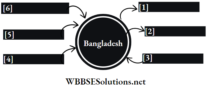
Question 3. Which branch of the monsoon causes rainfall in Cherrapunji and why?
Answer:

Branch Of The Monsoon Causes Rainfall In Cherrapunji:-

Indian monsoon has two branches-the Arabian Sea branch and the Bay of Bengal branch. Cherrapunji, located in the northeastern part of India, receives relief rainfall from the Bay of Bengal branch of monsoon winds.

The sun is vertically overhead on and around the Tropic of Cancer in May and June. As a result, an intensely hot low-pressure zone develops in northern India.

To fill that vacuum, cold moist winds from the Bay of Bengal rush in through Bangladesh to reach north-eastern India. Here, the moist monsoon winds get obstructed by the Khasi Hills of the Meghalaya plateau and plateau and cause profuse orographic rainfall on the windward slope of the hills.

WBBSE Class 8 Geography Rainfall Types

Cherrapunji is situated on the windward slope of the Khasi Hills and so this place records the world’s highest amount of rainfall (about 11777mm).

WBBSE Solutions For Class 8 Geography Chapter 5 Cloud And Rain Topic B Precipitation Bay of bengal branch of south-west monsoon


Question 4. Explain the mechanism behind cyclonic rainfall in temperate regions.
Answer:

Mechanism Behind Cyclonic Rainfall In Temperate Regions:-

In the temperate regions (35°-65° north and south latitudes), air masses of different temperatures blow from opposite directions. Hot and moist air blows from the tropics in the southwest, while cold and dry air blows from the polar region in the northeast. These two meet along a line called ‘front. The front is of mainly two types- warm front and cold front.

A warm front is defined as a region in which there is an active movement of warm air over cold air. A cold front, on the other hand, is defined as a front along which cold air is invading the warm air zone.

A disturbance is created when the opposite air masses meet. The warm air mass overrides the cold air as the former is lighter. The moisture in the warm air condenses on coming into contact with the cold air and causes rainfall.

Rainfall during a temperate cyclone is drizzling and lingering, unlike tropical cyclones where thundershowers are seen.

WBBSE Solutions For Class 8 Geography Chapter 5 Cloud And Rain Topic B Precipitation Temperate cyclonic rainfall

Characteristics of Precipitation for Class 8

Question 5. Explain the phenomenon of cyclonic rainfall in the tropical region.
Answer:

Phenomenon Of Cyclonic Rainfall In The Tropical Region:-

Tropical cyclones originate on either. side of the equator (5°-20° latitudes). The extremely hot condition creates a severe low-pressure area (called the ‘eye’ of a cyclone).

The relatively cold, heavy winds from surrounding places rush to fill in the vacuum. Again, those cold winds rise, on being heated and in this process expand, cool and condense, finally to precipitate.

The speed of these whirling cold winds increases proportionately with the increasing intensity of the low-pressure eye. The eye is a smaller area that remains calm and quiet with clear skies, but the spinning cold winds outside the eye cause violent storms, along with rainfall.

WBBSE Solutions For Class 8 Geography Chapter 5 Cloud And Rain Topic B Precipitation Tropical cyclonic rainfall

Class 8 Geography Solutions WBBSE

This cyclonic rain may develop into a more violent type of tropical storm. There is lighter tropical cyclonic rainfall also. Tropical cyclones are more powerful over water and lose energy while advancing landward. These cyclones usually occur in autumn.

WBBSE Solutions For Class 8 School Science Long Answer Type Questions WBBSE Solutions For Class 8 School Science Short Answer Type Questions
WBBSE Solutions For Class 8 School Science Very Short Answer Type Questions WBBSE Solutions For Class 8 School Science Review Questions
WBBSE Solutions For Class 8 School Science Solved Numerical Problems WBBSE Solutions For Class 8 School Science Experiments Questions
WBBSE Solutions For Class 8 Maths WBBSE Class 8 History Notes
WBBSE Class 8 History Multiple Choice Questions WBBSE Solutions For Class 8 History
WBBSE Solutions For Class 8 Geography


Question 6. What do you mean by the eye of a cyclone?
Answer:

Eye Of A Cyclone:-

The centre of a tropical cyclone, which has the lowest air pressure, is called the ‘eye’ of the cyclone.

The following are its features

  1. If the eye of a cyclone has very low pressure, the cyclone becomes more powerful and devastating.
  2. The eye has a clear sky and calm weather without any clouds.
  3. As winds move towards the central low-pressure region, i.e., the eye, according to Ferrel’s law, they move in an anti-clockwise direction in the northern hemisphere and a clockwise direction in the southern hemisphere.
  4. Winds converge at the eye.
  5. The radius of this eye can be 20km-80km.
  6. The region around the eye is generally covered by dense cumulonimbus clouds which cause strong cyclonic winds and heavy rainfall.

Class 8 Geography WBBSE


WBBSE Solutions For Class 8 Geography Chapter 5 Cloud And Rain Topic B Precipitation Eye Of Cyclone


Question 7. Classify precipitation.
Answer:

Classification Of Precipitation:-

Precipitation can be classified into- liquid form and solid form.

Liquid form of precipitation:

Hot and moist air cools and condenses on reaching the upper atmosphere and forms water droplets that float as clouds. Eventually, these are brought down as rain due to the gravitational pull of the earth.

Rainfall can be of three types

  1. Convectional rainfall
  2. Relief or orographic rainfall, and
  3. Cyclonic rainfall.

Drizzle is another liquid form of precipitation when droplets of water less than 0.5 mm in diameter come down as rain.

The solid form of precipitation:

Solid forms of precipitation are as follows

1. Snowfall:

In cold regions, tiny droplets of water alter to specks of snow and fall as a powdery substance on Earth. This is snowfall.

2. Hailstorm:

Upward air current pushes the droplets of water to a great height. Here the temperature drops and water droplets form small particles of ice.

When more droplets of water gather around these ice particles, they expand in volume and fall on earth with rain. This is called a hailstorm.

WBBSE Class 8 Geography Chapter 5 Notes on Precipitation

3. Sleet:

Combined precipitation of water- droplets and ice particles.

Question 8. Differentiate between fog and cloud?
Answer:

The differences between fog and cloud include

WBBSE Solutions For Class 8 Geography Chapter 5 Cloud And Rain Topic B Precipitation Diffferentiate between fog and cloud


Chapter 5 Topic B Precipitation Short Analytical Type Questions

Question 1. Explain the cycle of rainfall. Or, Explain the various stages of rainfall.
Answer:

Cycle Of Rainfall:-

Rainfall is the final product of the following stages

1. Evaporation:

Solar energy causes surface water from seas, oceans, rivers, lakes, and ponds to evaporate to form water vapour, which is lighter than air and rises.

2. Condensation:

The water vapour ascends, expands and cools. It condenses and converts into tiny particles of water that join each other and become larger droplets.

Short Answer Questions on Precipitation for Class 8

3. Precipitation:

When these larger droplets coalesce with each other, they cannot remain suspended any more. They are attracted by gravitational pull and cause Clouds that may rainfall on the earth’s surface.

The size of droplets varies, based on the particles they combine with. This rainwater flows back to the waterbodies as surface run-off.

Question 2. What do you know about convectional rainfall?
Answer:

Convectional Rainfall:-

In the torrid zone (including the tropics and the equator) a convection current sets in due to extremely hot conditions during the day.

The air in these regions has a lot of water vapour in it because of

  1. The greater surface area of water, and
  2. Higher temperature.

This moist and hot air rises rapidly and cools down on coming into contact with the cold upper layers of the atmosphere. Ultimately, it condenses to cause heavy rainfall at the third quarter of the day (or afternoon). This is known as ‘convectional rainfall.

Question 3. Why is convectional rainfall common in the Equatorial region?
Answer:

Convectional Rainfall Common In The Equatorial Region:-

When the earth’s surface gets extremely heated, the air above it becomes hot and rises vertically with all its moisture content.

In the higher layers of the atmosphere, the hot, moist air expands, cools condenses and eventually falls on Earth as rainfall. As it is caused by convection currents, it is called convectional rainfall.

The Equatorial region has a lot of water bodies and also has high temperatures. throughout the year. So, convectional rainfall occurs nearly every evening or in the late afternoon. This is also called a 40’clock rain or afternoon shower.

Class 8 Geography WBBSE

Question 4. Why does the amount of convectional rainfall increase in summer?
Answer:

Amount Of Convectional Rainfall Increase In Summer:-

Convectional rainfall is chiefly associated with temperature. In summer, during the day, the sun’s rays fall vertically on the land and consequently, the air above it becomes hot. Hot air has a greater capacity to hold moisture.

With increasing temperature, this hot and moist air rises vertically (due to convection current) expands, cools and finally condenses at higher levels of the atmosphere. This causes heavy rainfall (convectional) in the Equatorial region.

With an increase in temperature in summer, the amount of convectional rainfall also increases.

Question 5. Name the areas that receive heavy rainfall in India and explain why they do so.
Answer:

India receives rainfall mainly from the southwest monsoon winds, but these are highly irregular and sporadic. It has been observed after a thorough study that two regions receive the maximum amount of rainfall in India.

This is the western slope of the Western Ghats or Western coastal plains and eastern and Northeastern parts of India.

1. Western slope of the Western Ghats:

The western slope of the Western Ghats, being the windward side, receives plenty of orographic rainfall from the Arabian Sea branch of the southwest monsoon winds.

2. Eastern and north-eastern parts of India:

The entire region is located at the eastern and northeastern foothills of the Himalayas and receives heavy rainfall. The rain-bearing winds from the Bay of Bengal branch of the southwest monsoon get obstructed here and thus cause heavy rainfall.

Question 6. Think and comment on the relation between relative humidity and air temperature.
Answer:

Relative humidity and air temperature have an inverse relationship. The capacity of air to hold moisture depends on temperature. Thus, if air temperature increases, its capacity to hold moisture increases.

WBBSE Class 8 Geography Study Guide on Rainfall

Similarly, if the air temperature decreases, its capacity to hold moisture also falls. An increase in air temperature thus implies a fall in its relative humidity. Similarly, a decrease in air temperature results in an increase in relative humidity.

Question 7. What is a windward slope?
Answer:

Windward Slope:-

When moisture-laden winds blow from water bodies towards the land, at times, these are obstructed by mountains across their path. On striking the mountains, these winds rise the mountain slopes.

The rapid rise causes them to expand, cool, condense and ultimately to precipitate on these slopes only. The side of a mountain which receives relief or orographic rainfall is called the windward slope.

For example, the western slope of the Western Ghats is the windward side of the southwest monsoon winds (Arabian Sea branch).

Question 8. What is a rainshadow area?
Answer:

Rainshadow Area:-

The leeward side of a mountain is called a rainshadow area. After orographic or relief rainfall on the windward side of a mountain, when the wind crosses over the mountain and blows down the opposite or the leeward side, it has very little moisture left.

Its capacity to hold moisture also increases, as the air temperature increases. So, little or no precipitation occurs on this side. Hence, this leeward side is called a rainshadow area.

For example, the northern slope of the Khasi Hills in the Meghalaya Plateau is leeward and is therefore a rainshadow area.

Question 9. Why does the amount of rainfall received in Cherrapunji and Shillong differ drastically even though they are not very far away from each other?
Answer:

Cherrapunji is located on the windward slope of the Khasi Hills in Meghalaya, while Shillong is situated on the leeward slope of the same hill (just about 56km apart).

Due to this locational advantage, Cherrapunji receives very heavy rainfall from the southwest monsoon winds coming from the Bay of Bengal.

On the other hand, Shillong, being on the leeward side, is in the rainshadow area and remains comparatively dry even during the rainy season. The annual average rainfall at Cherrapunji is about 11777 mm, whereas Shillong records only about 2207 mm of rainfall annually.

Question 10. Why does the western slope of the Western Ghats receive heavy rainfall while the eastern slope remains dry?
Answer:

The Arabian Sea branch of the south-west monsoon winds on entering the Indian landmass, are first obstructed by the western slope of the Western Ghats.

The western slope receives plenty of orographic or relief rainfall from these moist winds. After the heavy downpour, the winds become lighter, cross the mountain and blow down the eastern slope into the interior of the Deccan Plateau.

WBBSE Class 8 Geography Precipitation Processes

It causes little or an almost negligible amount of rain there. So, the eastern slope of the Western Ghats is a rainshadow area.

Question 11. Why is rainfall in Pune lower than that in Mumbai?
Answer:

Rainfall In Pune Lower Than That In Mumbai:-

The Arabian Sea branch of the southwest monsoon winds causes heavy rainfall in the western coastal plain of India due to its location on the windward side of the Western Ghats.

This plain receives about 500cm-700cm of rainfall, annually. Mumbai is situated on this side of the Western Ghats and thus receives sufficient relief rainfall.

When the same branch of south-west monsoon winds reaches the leeward side of the Western Ghats, it cannot cause any significant amount of rainfall in the Deccan Plateau region due to lack of moisture content, thus turning it into a rainshadow area.

Pune lies in this rain shadow area and thus rainfall here is lower than that in Mumbai.

Question 12. What is relative humidity?
Answer:

Relative Humidity:-

The ratio between the amount of water vapour present at a specific temperature and the amount of water vapour that the same volume of air requires to become saturated at that temperature is called relative humidity.

It is always expressed as a percentage. Relative humidity can be measured by the following formula-

WBBSE Solutions For Class 8 Geography Chapter 5 Cloud And Rain Topic B Precipitation Relative humidity measured formula

For example, a definite volume of air absorbs 15 gm of water vapour at 25°C and it would be able to hold another 22.9 gm of water vapour before it becomes saturated. In that case

WBBSE Solutions For Class 8 Geography Chapter 5 Cloud And Rain Topic B Precipitation Relative humidity

Question 13. What is absolute humidity?
Answer:

Absolute Humidity:-

The total amount of water vapour present in a definite volume of air at a particular temperature is called its absolute humidity. It is greater during the day than at night, in summer than in winter, in the Equatorial region than in the Polar zones.

For example, if 1 cc of air contains 5gm of water vapour, the absolute humidity of that volume of air will be 5 gm/cc.

Types of Rainfall Explained for Class 8

Question 14. Write the differences between the windward slope and the leeward slope.
Answer:

The differences between windward slope and leeward slope are as follows

WBBSE Solutions For Class 8 Geography Chapter 5 Cloud And Rain Topic B Precipitation Diffferentiate between Windward and Leeward slope


Question 15. Write the differences between tropical cyclones and temperate cyclones.
Answer: The differences between tropical cyclones and temperate cyclones are as follows-

WBBSE Solutions For Class 8 Geography Chapter 5 Cloud And Rain Topic B Precipitation Diffferentiate between Tropical and Temperate Cyclone


Question 16. Differentiate between precipitation and rainfall.
Answer: The differences between precipitation and rainfall are as follows-

WBBSE Solutions For Class 8 Geography Chapter 5 Cloud And Rain Topic B Precipitation Diffferentiate between Precipitation and rain fall


Question 17. Why are dust particles necessary for the formation of clouds and rainfall?
Answer: Dust Particles Necessary For The Formation Of Clouds And Rainfall:

To start the process of condensation, there must be an abundant supply of microscopic dust particles in the air. Such particles are capable of attracting or absorbing water.

These are generally salt particles, pollens, etc. Water droplets become cool and condensed while moving in the upper air. These reside on the dust particles and form clouds. Later rainfall occurs from the clouds.

WBBSE Class 8 Geography Chapter 8 Question Answer

Question 18. Why do evergreen forests grow in the Equatorial region?
Answer: Evergreen Forests Grow In The Equatorial Region:-

Evergreen rainforests are the characteristic feature of the Equatorial region. These forests generally grow in the Equatorial region because of the following-

1. High temperature:

This region has high temperature throughout the year. Temperature generally varies between 25°C to 30°C. This condition favours the growth of evergreen forests.

2. Abundant rainfall:

The average annual rainfall in this region is about 250 cm. Plenty of convectional rainfall promotes the growth of evergreen forests.

3. High humidity:

The humidity level always remains high in this region. High humidity in the atmosphere is a major factor that helps in causing plenty of rainfall.

These are the reasons why evergreen forests are found in the Equatorial region due to favourable climatic conditions.

Question 19. What disruption or inconvenience does fog cause in our daily lives?
Answer: Fog causes several problems in our daily lives. Some of these are as follows-

  1. It obscures our visibility and hampers transportation via road, air and rail.
  2. Fog, in combination with smoke and dust, creates ‘smog’, which is very harmful for our health.
  3. Fog damages the crops.
  4. Fog influences the weather conditions of places locally.

Question 20. What are the different types of rainfall in India?
Answer: India is blessed with almost all kinds of rainfall. The different kinds of rainfall prevalent in India are-

  1. Convectional rainfall occurs in West Bengal during the early summer.
  2. Orographic or relief rainfall is prevalent in the windward slopes of mountains across the path of southwest monsoon winds. South-west monsoon winds again have two branches-
  3. The Arabian Sea branch that causes heavy rainfall along the western slope of the Western Ghats, and
  4. The Bay of Bengal branch dashes against the southern slope of the Khasi Hills in Meghalaya and causes heavy rainfall there.
  5. During autumn and the dewy season (called ‘Hemanta’ in Bengali), occasional cyclonic rainfall occurs in the coastal regions of India.
  6. Winter rain occurs in the north and north-western part of India particularly in Jammu and Kashmir, Himachal Pradesh, Uttarakhand, Uttar Pradesh and Punjab from the ‘western disturbances’ of the Mediterranean region.

Question 21. Why does it not rain from all the clouds?
Answer:

The following conditions are essential for the occurrence of rainfall from clouds-

WBBSE Class 8 Geography Chapter 8 Question Answer

  1. To start the process of condensation, there must be an abundant supply of microscopic dust particles in the cloud, otherwise condensation will not occur.
  2. The floating water droplets of a cloud are usually 0.01mm in radius. Unless these join together to become at least 0.5mm in diameter, these cannot be attracted by the gravitational pull of the earth and they cannot fall as raindrops.
  3. The floating droplets of water, which form a cloud, cannot cause rainfall until they coalesce with each other.
  4. The relative humidity of the atmosphere has to be 100%, otherwise, condensation and precipitation will not occur.

Question 22. Think and say why dew and fog are not classified as precipitation.
Answer:

Fog and dew are not regarded as forms of precipitation as these are not formed by the upward movement of air and do not earth’s surface due to the gravitational pull of the earth.

1. Dew:

The moisture deposited on objects such as grass, leaves and stones on the earth’s surface in winter nights is known as dew. Dew form when the sky is cloudless and when the radiation from the ground has cooled the lower layers of the atmosphere and the water vapour in it below the dew point.

WBBSE Solutions For Class 8 Geography Chapter 5 Cloud And Rain Topic B Precipitation Dew

2. Fog:

During winter nights, when the surface of the earth becomes very cold, the air just above it also cools and condenses, around dust particles, forming tiny droplets of water floating in the lower layer of the atmosphere appearing like smoke.

This is known as fog. Fog is essentially a type of cloud that forms at the surface of the earth, and is not any kind of precipitation.

WBBSE Solutions For Class 8 Geography Chapter 5 Cloud And Rain Topic B Precipitation Fog

Question 23. Different types of rainfall occur within West Bengal. Make a list of the different areas and different types of rainfall that occur there throughout the year.
Answer: The different types of rainfall occurring all over West Bengal are-

1. Convectional rainfall:

During early summer in every region of south and central Bengal, convectional rainfall occurs.

2. Cyclonic rainfall:

This type occurs in districts of North and South 24 Parganas, Kolkata, East and West Bardhaman, Bankura, East and West Midnapore, Birbhum, Howrah and Hooghly.

During the monsoon and autumn seasons, cyclonic rainfall occurs mainly in Digha, Sundarbans and Mandarmani areas.

3. Orographic rainfall:

Darjeeling, Jalpaiguri and other hilly areas in West Bengal experience this type of rainfall.

Question 24. Collect information regarding different types of rainfall that your locality experiences and note them down.
Answer:

The different types of rainfall that my locality (areas in and around Kolkata) experiences during different seasons are-

WBBSE Solutions For Class 8 Geography Chapter 5 Cloud And Rain Topic B Precipitation Diffferent types of rainfalls


Question 25. Write a short note on snowfall.
Answer: Snowfall:-

If the air temperature at the higher levels of the atmosphere is below the freezing point (0°C) of water, condensation of water vapour into ice particles takes place.

Generally, as snow falls due to the gravitational pull of the earth, it passes through the warm air, melts and drops down as rain.

But in mountainous regions or cold climatic zones, where the air is very cold even near the earth’s surface, snow falls in shapes similar to sugar crystals or fluffy bunches of cotton. This is snowfall.

WBBSE Class 8 Geography Chapter 8 Question Answer

Question 26. Describe the instrument used to measure the amount of rainfall.
Answer: Instrument Used To Measure The Amount Of Rainfall:-

Rainfall is measured by an instrument named a rain gauge. It consists of a funnel, usually 5 inches or 13 cm in diameter and a glass vessel or bottle of the same diameter. The funnel is fitted in such a manner that not a single drop of rainwater can escape. Rainwater is collected in the glass bottle for about 24 hours.


WBBSE Solutions For Class 8 Geography Chapter 5 Cloud And Rain Topic B Precipitation Rain gauge


The instrument is placed about one foot above the ground to prevent the entry of water from outside by splashing. The water collected is then measured in a measuring glass or cylinder to get the amount of daily rainfall.

Question 27. What do you mean by hail?
Answer: When clouds or tiny droplets of water are forced to rise high up in the sky by convectional air currents, the water droplets freeze into small grains of ice.

When more droplets of water gather around these ice particles they expand in volume and fall on earth with rain. This is called hail. Hailstorms are observed in sub-tropical and temperate zones.

When more droplets of water gather around these ice particles they expand in volume and fall on earth with rain.

WBBSE Class 8 Geography Chapter 8 Question Answer

Chapter 5 Topic B Precipitation Short Answer Type Questions

Question 1. What is precipitation?
Answer:

Precipitation:-

When water vapour in the atmosphere condenses and falls on the earth as water droplets or ice particles, due to the gravitational pull of the earth, it is called precipitation.

Question 2. What is rainfall?
Answer: Rainfall:

The evaporated water rises with hot, light air and condenses after reaching the upper strata of the atmosphere to form tiny droplets of water that form clouds.

When these floating water droplets join together to become bigger (with a diameter of 2mm), they drop down as rainfall due to the earth’s gravitational pull. Rainfall is a liquid form of precipitation.

Question 3. Name two places that experience convectional rainfall throughout the year.
Answer: Two Places That Experience Convectional Rainfall Throughout The Year:

Two places that experience convectional rainfall throughout the year are-

  1. Amazon Basin in South America and
  2. Zaire Basin in Africa.

Question 4. Why does rainfall occur from cool air?
Answer:

Rainfall Occurs From Cool Air:-

If air loses heat and becomes cool, the relative humidity increases and the air gets saturated faster. After that, the water-holding capacity of the saturated air decreases and the water droplets come down to the surface as rainfall as a result of the earth’s gravitational pull.

Therefore, when the air cools down, the water droplets become denser and rainfall occurs.

WBBSE Class 8 Geography Chapter 8 Question Answer

Question 5. What do you understand from the statement “relative humidity of an area is 70%”?
Answer:

Relative Humidity Of An Area Is 70%:-

The relative humidity of an area is 70% implies that the air at that place and at that given temperature needs 30% more water vapour to reach 100%, i.e., to become saturated.

Saturated air has 100% relative humidity while dry air has 0% relative humidity.

Question 6. What is orographic rainfall?
Answer:

Orographic Rainfall:-

Being obstructed by a mountain across its path, moist air rises very rapidly along the mountain slope and expands, cools and condenses there, precipitating only on that side of the mountain. This is called orographic rainfall (‘oros’, means ‘mountain’ and ‘graphy’ means to ‘rise’). For example, orographic rainfall occurs on the western slope of the Western Ghats in India.

Question 7. What is cyclonic rainfall?
Answer:

Cyclonic Rainfall:-

Low pressure over an area attracts cold air from the surrounding high-pressure areas towards it at a great speed. The lighter hotter air of that region rises.

It expands to cool and condense in the upper layers to form clouds, finally precipitating with thunder and lightning. This is called ‘cyclonic rainfall.

It is also called frontal rain in temperate areas because a ‘front’ or boundary is formed between the two contrasting air masses.

Question 8. What is ‘Aswiner Jhar?
Answer:

As winter Jhar:-

In the months of ‘Aswin’ and ‘Kartik’ (October-November) of the Bengali year Bangladesh, West Bengal and eastern India experienced a cyclonic storm. This is called ‘Aswiner Jhar’. It is caused by the retreating monsoon winds. This is more common in the coastal regions of the Bay of Bengal.

Question 9. Name any two recent cyclones in India.
Answer:

Two Recent Cyclones In India:-

The names of two recent cyclones in India are

  1. Hudhud in 2014 and
  2. Fani in 2019.

Question 10. Name the different forms of condensation.
Answer: Different Forms Of Condensation:                     

The common forms of condensation are dew, frost, fog, smog and clouds. Fog and clouds are the most important concerning atmospheric processes.

Question 11. What is acid rain?
Answer: Acid Rain:

When oxides of sulphur and nitrogen released in the air due to pollution react with water vapour in the atmosphere to form acid, which when comes down to rainwater is known as acid rain.

It has harmful effects on plants, aquatic life, as well as on buildings. Acid rains mainly occur as a result of air pollution.

Question 12. What is frost?
Answer: Frost:

In cold countries and at high altitudes of the hot or torrid zone, when the night temperature is minimal, dew freezes and becomes hard and solid. This is called frost.

Question 13. What is isohyet or equipluve line?
Answer:

Isohyet Or Equipluve Line:-

The imaginary line that joins places on a map, recording equal average annual rainfall at a particular time is called the isohyet equipluve line.

The characteristics of these lines are

  1. These are usually curved lines.
  2. The value of the lines is maximum in the Equatorial region, while it is minimum at the poles.
  3. These lines never touch or cross each other.


WBBSE Solutions For Class 8 Geography Chapter 5 Cloud And Rain Topic B Precipitation Isohyet or Equipluve line


Question 14. Why is less dew observed in dry regions?
Answer:

Less Dew Observed In Dry Regions:-

The air in dry areas has a lesser amount of water vapour in it. So, at night when the heat radiates back from the surface, the air near the surface becomes cooler but condensation does not take place due to lack of water vapour.

Thus, less dew is observed in dry regions.

Question 15. Why is fog mainly seen in winter and on waterbodies?
Answer:

Fog Mainly Seen In Winter And On Waterbodies

The amount of heat that a landmass can absorb during the day in winter, radiates back more heat than that during long winter nights.

Thus, when the layer near the earth’s surface gets cooled, the water vapour in it condenses around dust particles present in the air and leads to the formation of fog in winter.

Also, the air above the waterbodies having more water vapour content than the landmass, causes the formation of fog mainly on waterbodies.

Class 8 Geography Solution WBBSE

Question 16. Why does a barefooted morning walk on the grass make your feet wet in winter?
Answer:

Barefooted Morning Walk On The Grass Makes Your Feet Wet In Winter:-

Dew is a form of condensation which consists of tiny droplets of water on the surface of objects rather than on dust particles in the air. It is produced when the heat radiation from the ground surface cools the lower layers of the atmosphere in night.

As a result, the water vapour in it condenses and gets deposited on trees and grass surfaces as droplets of water called dew. Thus, a barefooted morning walk on the grass makes our feet wet in winter.

Question 17. Briefly write about the drizzle.
Answer:

Drizzle:-

Often tiny droplets of water (0.5 mm or less in diameter) fall continuously on Earth from nimbostratus clouds over a large area.

It may be the result of low pressure in that region. These droplets are so light that they float along with the wind. This type of rainfall is called drizzle.

Question 18. What is mist?
Answer: Mist:

Water vapour, which condenses and descends as fine droplets, remains suspended in the air, and takes a smoke-like, appearance and is called mist. It is visible just above the earth’s surface. It is less dense and long-lasting than a fog.

Question 19. What is sleet?
Answer: Sleet:

Sleet is fine particles of ice mixed with rain. This form of precipitation occurs when the lower layers of the atmosphere are cooled down to almost the freezing point.

Question 20. What type of rainfall is generally observed in our country in the monsoon season?
Answer: Type Of Rainfall Is Generally Observed In Our Country In The Monsoon Season:

Our country receives two types of rainfall in the monsoon season.

These are

  1. Orographic or relief rainfall in the mountain regions,
  2. Cyclonic rainfall in many places at the end of the monsoon.

Question 21. Write a short note on moisture retaining capacity.
Answer:

Moisture Retaining Capacity:-

Moisture retaining capacity refers to the capacity of an air of a certain volume at a certain temperature to retain the maximum amount of moisture content. It is also known as humidity capacity.

It is positively related to temperature, i.e., the higher the temperature, the higher the retention capacity and vice versa. It is expressed in grams per cubic centimetre.

Class 8 Geography Solution WBBSE

Chapter 5 Topic B Precipitation Multiple Choice Questions Choose The Correct Option

Question 1. Rainfall is of-

  1. 2 types
  2. 3 types
  3. 4 types
  4. 5 types

Answer: 2. 3 types

Question 2. The most commonly occurring rainfall on the earth is-

  1. Convectional rainfall
  2. Orographic rainfall
  3. Cyclonic rainfall
  4. Sleet

Answer: 2. Orographic rainfall

Question 3. Rainfall that occurs when the sun’s heat causes water on the earth’s surface to rise as a vapour to form clouds, is known as

  1. Convectional rainfall
  2. Orographic rainfall
  3. Drizzle
  4. Cyclonic rainfall

Answer: 1. Convectional rainfall

Question 4. Convectional rainfall occurs in the Equatorial region during-

  1. Summer
  2. Winter
  3. The entire year
  4. Spring

Answer: 3. The entire year

Question 5. The type of rainfall that is observed in the Equatorial region is-

  1. Convectional
  2. Frontal
  3. Orographic
  4. Drizzle

Answer: 1. Convectional

Class 8 Geography Solution WBBSE

Question 6. Relative humidity is expressed in terms of-

  1. Decimal
  2. Degree
  3. Percentage
  4. Mass

Answer: 3. Percentage

Question 7. In comparison to cold air, warm air is-

  1. Lighter
  2. Of equal weight
  3. Heavier
  4. None of the above

Answer: 1. Lighter

Question 8. In comparison to dry wind, moisture-laden wind is-

  1. Lighter
  2. Heavier
  3. Of equal weight
  4. None of the above

Answer: 1. Lighter

Question 9. The relative humidity of saturated air is-

  1. 0%
  2. 100%
  3. 50%
  4. 150%

Answer: 2. 100%

Question 10. If the temperature of a volume of air increases, its capacity to hold moisture-

  1. Increases
  2. Remains the same
  3. Decreases
  4. None of the above

Answer: 1. Increases

Question 11. Rainshadow regions are formed along the

  1. Slopes of the foothills
  2. Leeward slope
  3. Windward slope
  4. Intermediate slope

Answer: 2. Leeward slope

Question 12. The branch of monsoon wind that causes rainfall in Mawsynram, India, is the

  1. Bay of Bengal branch
  2. Arabian Sea branch
  3. Indian Ocean branch
  4. Pacific Ocean branch

Answer: 1. Bay of Bengal branch

Question 13. The slope of the Khasi-Jaintia hills, on which Shillong is located, is the

  1. Northern slope
  2. Eastern slope
  3. Southern slope
  4. Western slope

Answer: 1. Northern slope

Question 14. The part of the hill that experiences relief rainfall is the

  1. Windward slope
  2. Speak
  3. Leeward slope
  4. Foothills

Answer: 1. Windward slope

Class 8 Geography Solution WBBSE

Question 15. Rainfall that occurs when a warm air mass meets a cold air mass, and the warm, less dense air is pushed up over the cold, dense air is called-

  1. Convectional rainfall
  2. Orogenic rainfall
  3. Drizzle
  4. Frontal rainfall

Answer: 4. Frontal rainfall

Question 16. Frontal rainfall is observed in the

  1. Equatorial regions
  2. Temperate regions
  3. Polar regions
  4. Tropical regions

Answer: 2. Temperate regions

Question 17. ‘Ashwiner Jhar’ in West Bengal is an example of-

  1. Local rainfall
  2. Relief rainfall
  3. Convectional rainfall
  4. Cyclonic rainfall

Answer: 4. Cyclonic rainfall

Question 18. The rainfall that is commonly associated with thunderstorms is-

  1. Drizzle
  2. Convectional rainfall
  3. Cyclonic rainfall
  4. Relief rainfall

Answer: 2. Convectional rainfall

Question 19. Rainfall due to the effect of temperate cyclones is observed in-

  1. Western India
  2. Central Europe
  3. Eastern India
  4. Southern India

Answer: 2. Central Europe

Question 20. Tropical cyclones are formed in-

  1. 5°-20° latitudes
  2. 35°-60° latitudes
  3. 20°-35° latitudes
  4. 60°-80° latitudes

Answer: 1. 5°-20° latitudes

Question 21. The Kalbaishakhi rain that occurs in April and May in India is an example of

  1. Convectional rainfall
  2. Orographic rainfall
  3. Cyclonic rainfall
  4. Rainfall due to the formation of the anticyclonic condition

Answer: 1. Convectional rainfall

Question 22. The unit that measures rainfall is-

  1. Celsius
  2. Millibar
  3. Centimetre
  4. Pascal

Answer: 3. Centimetre

Question 23. The instrument used to measure rainfall is known as

  1. Altimeter
  2. Barometer
  3. Anemometer
  4. Rain Gauge.

Answer: 4. Rain Gauge.

Question 24. A line on a map connecting places having the same amount of rainfall in a given period is known as-

  1. Isotherm
  2. Isobar
  3. Isohume
  4. Isohyet

Answer: 4. Isohyet

Question 25. ‘Ashwiner Jhar’ occurs in

  1. January
  2. April
  3. July
  4. October

Answer: 4. October


Chapter 5 Topic B Precipitation Very Short Answer Type Questions Fill In The Blanks

Question 1. _______ is the phenomenon by which water in its solid and liquid forms falls to the ground from clouds due to gravity.
Answer: Precipitation

Question 2. Tiny water droplets condense to form clouds, which keep growing till they become too heavy to remain suspended in the atmosphere and then fall from the sky as _______, due to gravitational pull.
Answer: Rain

Question 3. _______cyclones typically form over large bodies of relatively warm water.
Answer: Tropical

Question 4. A relative humidity of 100% indicates that the air is _______ with water.
Answer: Saturated

Question 5. _______ rainfall occurs when moist air rises as it moves over a mountain range.
Answer: Orographic

Question 6. The area to the north of Meghalaya Plateau is a _______ area.
Answer: Rainshadow

Question 7. West Bengal experiences spells of heavy convectional rain during the _______ afternoons.
Answer: Summer

Question 8. The highest amount of rainfall in the world is recorded in _______.
Answer: Mawsynram

Question 9. The foothills of the eastern Himalayas _______ experience rainfall.
Answer: Orographic

Question 10. The southwest monsoons strike the western coast of India and cause heavy rainfall on the _______ slope of the Western Ghats.
Answer: western

Question 11. The western slope of the Western Ghats experiences _______ type of rainfall.
Answer: Orographic

Question 12. A high _______ content is necessary for precipitation.
Answer: Water vapour

Question 13. The western disturbances over the northern Indian subcontinent are actually _______ cyclones.
Answer: Temperate

Question 14. One of the rainshadow areas in India is _______on the Meghalaya plateau.
Answer: Shillong

Question 15. _______ refers to a kind of fog that has soot or smoke particles.
Answer: Smog

Question 16. Most thunderstorms occur from _______ clouds.
Answer: cumulonimbus

Class 8 Geography Solution WBBSE

Write True Or False

Question 1. Rain helps to cool down the weather.
Answer: True

Question 2. Cyclonic rainfall in temperate regions occurs during the winter season.
Answer: True

Question 3. The moisture retention capacity of warm air is lower.
Answer: False

Question 4. Tropical cyclones become weak while moving on the landmasses.
Answer: True

Question 5. The wettest places on the earth are usually located in the Equatorial region.
Answer: False

Question 6. Cyclonic rainfall is most common in the Equatorial region.
Answer: False

Question 7. Rain is the most common form of precipitation.
Answer: True

Question 8. Convectional rain occurs on the earth’s surface when a conditionally unstable or moist atmosphere becomes heated more than its surroundings, leading to significant evaporation.
Answer: True

Question 9. All types of clouds lead to rainfall.
Answer: False

Question 10. Most of the rainfall in India is a result of orographic rainfall.
Answer: True

Question 11. Convectional rainfall is more common in high latitudes.
Answer: False

WBBSE Chapter 5 Topic B Precipitation Match The Columns

1.WBBSE Solutions For Class 8 Geography Chapter 5 Cloud And Rain Topic B Precipitation Match the columns

Answer: 1. C, 2. D, 3. B, 4. E, 5. A


Answer In One Or Two Words

Question 1. By which process does the air heat up in case of convectional rainfall?
Answer: Convection.

Question 2. Name two countries that experience convectional rainfall throughout the year.
Answer: Uganda, Indonesia.

Question 3. Name a rainshadow region in India.
Answer: Deccan Plateau.

Question 4. Which slope of the mountain receives less rainfall?
Answer: Leeward slope.

Question 5. How many types of cyclonic rainfall are there?
Answer: Two.

Question 6. By what name is the autumn cyclone called in West Bengal?
Answer: Aswiner Jhar.

Question 7. What type of rainfall is observed in India during autumn?
Answer: Cyclonic rainfall.

Question 8. Which type of cyclone persists for a long time?
Answer: Temperate cyclones.

Question 9. Name the strongest tropical cyclone in the world.
Answer: Tornado.

Class 8 Geography Solution WBBSE

Chapter 5 Topic B Precipitation Conceptual Questions And Answers Who am I?

Question 1. I am the highest cloud. I look like a mare’s tail. I create a remarkable spectrum during the sunset. However, I do not cause rainfall.’ Who am I?
Answer: Cirrus cloud

Question 2. ‘I am a vertical, dome-shaped cloud. I cause rainfall with thunderstorms.’-Who am I?
Answer: Cumulonimbus cloud

Question 3. I am born from water due to insolation. I am light and I float in the air. I form clouds and fog.’ Who am I?
Answer: Water vapour

Question 4. I occur in the regions that have a higher percentage of water bodies and which receive vertical rays of the sun.’ -Who am I?
Answer: Convectional rainfall

Question 5. ‘I stay at the centre of a cyclone. The sky in my area remains clear and calm but my surroundings experience storms.’ -Who am I?
Answer: Eye of a cyclone

Question 6. I drop down as a solid substance from clouds instead of raindrops due to the extremely cold weather.’ Who am I?
Answer: Snow

Question 7. ‘You can see me in early winter mornings. I bar your visibility. I am almost like smoke.’ -Who am I?
Answer: Fog

Question 8. I stick on the blades of grass like tiny droplets of water, early in the morning. I am mostly seen in winter.’-Who am I?
Answer: Dew

Scrambled Words

1. MLUCO UNBIASED
2. UROICR MLUSUC
3. PEH CARURJNI
4. LFNWASLO

Answers:

1. CUMULONIMBUS
2. CIRROCUMULUS
3. CHERRAPUNJI
4. SNOWFALL

Fill Up The Blanks In The Knowledge Hive

Question 1. Fill in the knowledge hive with information on the cumulonimbus cloud.


WBBSE Solutions For Class 8 Geography Chapter 5 Cloud And Rain Topic B Precipitation Fill in the blanks

Answers:

1. It is a vertical cloud.
2. It is dome-shaped and greyish or black in colour.
3. This cloud sometimes causes hailstorms also.
4. This cloud causes heavy rainfall along with thunderstorms.
5. This cloud is also called a thundercloud.


Chapter 5 Topic B Precipitation Strike the odd one out

Question 1. Cirrus, Cirrostratus, Cirrocumulus, Stratus
Answer: Stratus (not a high cloud)

Question 2. Stratus, Stratocumulus, Cirrus, Nimbostratus
Answers: Cirrus (not a low cloud)

Question 3. Convectional rainfall, Torrential rainfall, Cyclonic rainfall, Orographic rainfall
Answers: Torrential rainfall (not a type of rainfall)

Question 4. Snowfall, Dew, Sleet, Hailstorm
Answers: Dew (not a type of precipitation)


Correct The Following

1. The cirrus clouds appear like the scales of a mackerel fish.

2. Cumulus cloud is also known as a thundercloud.

3. The process by which water changes from liquid to vapour is known as condensation.

4. Hailstorm is a mixture of water droplets and snowflakes.

Answers:

1. Cirrocumulus
2. Cumulonimbus
3. Evaporation
4. Sleet

Crossword


WBBSE Solutions For Class 8 Geography Chapter 5 Cloud And Rain Topic B Precipitation Crossword

CLUES

Down:

1. Place that gets the highest amount of rainfall in the world.
2. This type of cyclones occur in the mid-latitudes in winter.
3. Rainfall is produced when moist air moves up the sides of hills and mountains.

Across:

4. Phenomenon of moisture falling on ground from clouds due to gravity.
5. Cyclonic storm in the South China Sea.
6. Imaginary line joining places having equal amounts of rainfall.

Answers:

Down: 1. MAWSYNRAM, 2. TEMPERATE, 3. OROGRAPHIC
Across: 4. PRECIPITATION, 5. TYPHOON, 6. ISOHYET


Chapter 5 Topic B Precipitation Advanced Questions And Answers

Question 1. Write a short note on smog.
Answer:

Smog:-

Fog mixed with smoke is called smog. It is a consequence of air pollution and is very harmful for the living world. Industrial towns emit poisonous gases from factories which combine with the fog to form smog.

The cities of London and Los Angeles suffer from deadly smog during winter evenings.

Question 2. What are nor’westers?
Answer:

Nor’wester:-

It is a kind of abrupt or sudden wind that causes rainfall with thunder, lightning and hail at times, in the summer afternoons in eastern India, including West Bengal and its adjacent areas.

As the wind comes from the northwest, it is called the Nor’wester. This rainfall is also known as ‘Kalbaishakhi’.

Question 3. What are Western disturbances?
Answer:

Western Disturbances:-

During winter February), India enjoys sunny and pleasant weather conditions because of the sun’s apparent annual migration to the southern hemisphere after September 23.

Due to the shifting of wind belts along with climatic belts, the Mediterranean region comes under the influence of the westerlies that cause cyclones and heavy rain.

This rain and storm that comes from the west in winter is called ‘western disturbances. Under the influence of the western disturbances, Jammu and Kashmir, Himachal Pradesh, Uttarakhand, western UP, Haryana and Punjab receive this type of winter rainfall.

This winter rain is beneficial for the cultivation of wheat in Punjab.

Question 4. Why is the Bay of Bengal more prone to cyclones than the Arabian Sea?
Answer:

Bay of Bengal more prone to cyclones than the Arabian Sea:-

The reasons for Bay of Bengal being more prone to cyclones than the Arabian Sea are as follows-

  1. The Arabian Sea has a greater expanse of water than the Bay of Bengal, which is rather restricted by land on three sides. So, the Bay of Bengal retains heat for a longer time. As a consequence, it creates a low-pressure zone, which gives rise to cyclones.
  2. The water of the Bay of Bengal is denser than that of the Arabian Sea. Due to the lack of suitable conditions, the bay water cannot lose heat quickly. So, a higher atmospheric temperature leads to the formation of a low-pressure zone, which further leads to the occurrence of cyclones.

The Bay of Bengal is thus more prone to cyclones than the Arabian Sea.


Chapter 5 Topic B Precipitation Formative


Participation

This segment will indicate how much the students have actively participated and taken the initiative during the class.

The heat of the sun is responsible for the formation of water vapour from waterbodies. Since water vapour is lighter than air, it rises and accumulates to form clouds. With reference to this information, answer the following:

Question 1. Apart from the sun’s heat, what else is responsible for the formation of water vapour?
Answer: Moisture is added to the atmosphere due to the transpiration process in plants.

Question 2. What is the relation between cloud formation and rainfall?
Answer: Clouds filled with water vapour cause rainfall on Earth due to gravity.

Question 3. How many types of rainfall are there?
Answer: There are three types of rainfall.

Question 4. Which instrument is used to measure the amount of rainfall?
Answer: Rain gauge.


Interpretation And Application

This segment will test whether the students have understood the topics, or whether they are just mugging up.

Question 1. Take some water in a glass plate and a glass jar and keep them exposed to the weather. What change will be observed in the amount of water kept in the two vessels after two or three days?
Answer:

If we take some water in a glass plate and a glass jar and keep them exposed to the weather, we will see the amount of water has changed. Both the glass plate and the glass jar will have a lesser amount of water than it was kept in them earlier.

But the water in the glass jar will be more than the glass plate. The glass plate having a flat area, Fig. Set up for the experiment gets more sunlight, hence more water will evaporate from its surface.


WBBSE Solutions For Class 8 Geography Chapter 5 Cloud And Rain Topic B Precipitation Set up for the experiment


On the other hand, the glass jar having a narrow mouth, less amount of water will be evaporated from it. Thus it can be said that the rate of evaporation depends on the area of the upper surface of the water bodies.

Question 2. Keep a few cubes of ice in a tumbler. After a while, droplets of water accumulate on the tumbler. Your hands get wet when you hold the tumbler. Air around the tumbler has cool down on its contact and the water vapour in it becomes a water droplets. Which process does this happen as a result of?
Answer:

It is observed that if some ice cubes are kept in a glass, water droplets accumulate outside the glass. When the air around the cold glass comes into contact with it, the water vapour accumulates on the glass surface as water droplets.

Thus, on holding the glass, our hands get wet. This process is known as condensation. This is how clouds form.


WBBSE Solutions For Class 8 Geography Chapter 5 Cloud And Rain Topic B Precipitation Set up for the experiment.


Question 3. Prepare a model of orographic rainfall and point out windward and leeward slopes. ▸ Materials required: Thermocol, knife, gum, cotton, colour, painting brush, several thin sticks, pen.
Answer:

Model-making:

With the help of these materials, the model can be prepared following the steps given below-

Stage-1:

A big sheet of thermocol is taken and cut into rectangular shapes. Then with the help of gum, they are fixed, one above the other.

Stage-2:

When the gum dries up, with the help of a knife, shapes of waterbody, landmasses and mountains are made on them. (As shown in the picture.)

Stage-3:

After that, blue colour for a waterbody, yellow for a landmass and grey for the mountain are used to paint the surface.

Stage-4:

Now using those thin sticks and glue, clouds are made with cotton. Those cotton are painted grey to make it look as original cloud.

Stage-5:

Small pieces of thermocouple are cut. ‘Ocean’, landmass’, ‘windward slope’ and ‘leeward slope’ are written on paper individually and fixed on the pieces of thermocol. Now with sticks those clouds are fixed where they are necessary.


WBBSE Solutions For Class 8 Geography Chapter 5 Cloud And Rain Topic B Precipitation Model of Orographic Rainfall


Questioning And Experimentation

This segment will investigate the student’s understanding of the subject,

Question 1. Among all the clouds that you have come to know, note down the types you observe in the sky against the dates on which you see them.
Answer:

I am Samir Rehman, a resident of Howrah. The clouds that I could identify in the sky are-

  1. Cirrus cloud: 26 October, 29 September.
  2. Cirrostratus cloud: 11 July, 6 August, 21 September, 1 October.
  3. Cirrocumulus cloud: 7 October, 10 October, 14 November, 19 November, 3 December, 4 December
  4. Altostratus cloud: 7 July, 8 July.
  5. Altocumulus cloud: 16 October, 19 October
  6. Stratocumulus cloud: 12 October, 14 October
  7. Stratus cloud: 29 June, 30 June, 1 July, 2 July
  8. Nimbostratus cloud: 3 July-5 July, 14 August-16 August
  9. Cumulonimbus cloud: 14 April-18 April, 26 April, 2 May, 11 May, 19 May

Aesthetics And Creativity

This segment will check the aesthetic sense and creativity of the students.

Question 1. Hand-made clouds: Try to form clouds in your own home.
Answer:

Materials:

  1. A plastic bottle of 1-litre capacity,
  2. Hot water (not boiling),
  3. Matchsticks.

Process:

  1. The lower portion of the bottle is filled with hot water.
  2. A lighted matchstick is put inside the bottle and made sure that the bottle is filled with smoke.
  3. Then the lid is put on the bottle and closed.
  4. Finally, pressure is put on the bottle using hands a few times. Once that is done, it is observed that a cloud has formed within the bottle.


WBBSE Solutions For Class 8 Geography Chapter 5 Cloud And Rain Topic B Precipitation Set up for the experiment.,


Reasons:

  1. Hot water in the bottle increases the moisture-retaining capacity of the air within the bottle.
  2. The temperature of the matchstick helps the air inside the bottle to saturate.
  3. When air containing water vapour cools down a bit, the water vapour within it transforms into tiny water droplets and floats around. These together make up the cloud inside the bottle.

WBBSE Class 8 Geography Chapter 5 Topic A Cloud

Chapter 5 Cloud And Rain Synopsis

Clouds are defined as the aggregate of numerous tiny water droplets around dust particles or a mixture of both in the air and the ground surface. Generally, the diameter of the water droplets in clouds is 0.02 mm or less.

The clouds which occur at an average minimum height of 20000ft are known as high clouds. This cloud group consists of cirrus, cirrostratus and cirrocumulus.

Cirrus clouds are whitish transparent, light and feathery clouds, through which the sun and the moon are visible.

Cirrostratus clouds are generally white and are spread in the sky like thin, white film. The clouds often form a halo around the sun or the moon.

Cirrocumulus clouds appear in the sky as cotton wool and make the sky look like the scales of a mackerel fish. The cloud indicates fair weather.

Read and Learn More WBBSE Solutions For Class 8 Geography

The location of medium clouds in the sky varies between 6500ft to 20000ft. This group consists of altostratus and altocumulus clouds.

Altostratus clouds, having a fibrous appearance, grey to bluish in colour yield widespread and continuous rainfall. The sun seems dull through these clouds.

WBBSE Class 8 Cloud Formation Overview

Altocumulus clouds are characterised by wavy patterns, flat, rounded structures and white to greyish colour. The sky is visible through the gaps in these cloud masses.

Low clouds are found up to a height of 6500ft from the ground. Stratocumulus, stratus, and nimbostratus clouds come under this group.

Stratocumulus clouds are layered clouds appearing like a heap. These are also called Bumpy clouds as the layers seem to be rolling along the sky.

Stratus clouds are low-altitude, grey-coloured, fog-like clouds. These clouds pose great difficulty to mountaineers and pilots. These clouds can sometimes cause drizzle.

Nimbostratus clouds are associated with continuous and copious precipitation. They are thick, dense, grey to black in colour and indicate bad weather.

Vertical clouds are usually found at an average minimum height of 16000 ft. They consist of cumulus and cumulonimbus clouds.

Cumulus clouds are thick, and dense with a high vertical extent. The top surface is white and irregular and the bottom part is black and flat. These clouds generally fair indicate fair weather.

Cumulonimbus clouds show great vertical development and produce heavy rains or hailstorms accompanied by thunderstorms. The clouds may be whitish-grey or black in colour and dome-shaped. The top and bottom parts of these clouds are flat.

The process of conversion of water into its gaseous form, i.e., water vapour is called evaporation.

When the temperature of moist air reaches the dew point, it becomes saturated. In other words, air having 100% relative humidity is called saturated air.

The temperature at which a mass of air becomes saturated is called its dew point.

The process of conversion of water vapour into water droplets is called condensation.

When water vapour in the atmosphere condenses and falls on the earth as water droplets or ice particles, due to the gravitational pull of the earth, it is called precipitation.

The major forms of precipitation include rainfall, drizzle, sleet, hail and snow.

During cloud formation, the water vapour present in the atmosphere condenses to form larger droplets of water. These droplets fall on the earth due to gravitational pull.

This is called rainfall. There are mainly three types of rainfall- convectional rainfall, orographic rainfall and cyclonic rainfall.

Relative humidity is defined as the ratio of the amount of water vapour present in a fixed volume of air at a particular temperature and the maximum amount of water vapour that the volume of air can hold at that temperature.

Cherrapunji in Meghalaya, being situated on the windward slope receives a mean annual rainfall of 11777mm.

Cyclonic or frontal rainfall is always associated with cyclones.

WBBSE Class 8 Geography Chapter 5 Topic A Cloud

Class 8 Geography Chapter 5 Types of Clouds

A tropical cyclone generally occurs between 5 and 20° latitudes in both hemispheres. The innermost part (or centre) of this cyclone is known as the eye of the cyclone.

Aila, Phailin, Fani and Hudhud are some notable examples of tropical cyclones that have occurred in recent times.

A temperate cyclone occurs when two different air masses (warm and cold) converge in the temperate region. The mid-latitude countries experience rainfall mainly in winter due to this type of cyclone.

When very tiny droplets of water (less than 0.5mm in diameter) come down to the surface of the earth as rain, it is called a drizzle.

Sleet refers to the combined precipitation of water droplets and ice.

When clouds or tiny droplets of water are forced to rise high up in the sky by convectional air currents, the water droplets freeze into small grains of ice.

When more droplets of water gather around these ice particles they expand in volume and fall on earth with rain. This is called hail.

Snowfall is common in regions with cold climates or in high mountainous areas, where temperatures are below freezing point.

Dew falls on leaves and blades of grass mainly on winter nights. A cloudless sky and calm weather are the necessary conditions for dew formation.

When water vapour condenses around the tiny dust particles present in the air near the ground and appears like smoke, it is called fog. It generally occurs in winter and reduces horizontal visibility.

A rain gauge (also known as a udometer, pluviometer or ombrometer) is an instrument that is used to measure the amount of rainfall.

A line on a map (usually, a weather map) connecting points having an equal amount of rainfall in a given period is known as isohyet.

Chapter 5 Topic A Clouds Analytical Type Questions

Question 1. What are clouds? How are they formed?
Answer:

Clouds:

Clouds are defined as the aggregate of numerous tiny water droplets around dust particles or a mixture of both in the air above the ground surface. Generally, the diameter of the water droplets in clouds is 0.02 mm or less.


WBBSE Solutions For Class 8 Geography Chapter 5 Cloud And Rain Topic A Cloud Stages of cloud formation


Stages of cloud formation:

According to climatologists, clouds form through various stages. These are discussed below-

1. Evaporation:

Water from various water bodies changes to water vapour by solar insolation. Water vapour, being lighter than air, rises to the higher layers of the atmosphere.

In addition to this, moisture discharged by trees and plants during transpiration is added to the atmospheric water vapour content.

Understanding Clouds for Class 8 Students

2. Condensation:

Condensation of water vapour takes place at this stage mainly at higher altitudes, when it comes into contact with cooler air. The cooler the air, the lower is its capacity to hold moisture.

Eventually, the temperature of the moist air mass reaches its dew point and the air gets saturated. When the temperature falls below the dew point, the finer water particles combine to form droplets of water or snow.

3. Clouds and precipitation:

The tiny droplets of water and snow, while floating in the sky, settle around existing. dust particles, pollen grains and other impurities in groups or patches and float in the air to form clouds.

Precipitation from these clouds occurs when they are unable to hold the moisture any further and the water flows back into the water bodies.

Question 2. Discuss the different types of high clouds or high-altitude clouds.
Answer:

Different Types Of High Clouds Or High-Altitude Clouds:-

Normally, high clouds or high altitude clouds are on average found at a minimum height of 20000 ft above the surface of the earth.

There are three subdivisions of high-altitude clouds

  1. Cirrus
  2. Cirrocumulus and
  3. Cirrostratus.

1. Cirrus:

The features of these clouds are

  1. This type of cloud are found at maximum height and resembles feathers or fluffs of cotton or at times the tail of a mare.
  2. Cirrus, being formed of tiny ice crystals, is white and transparent.
  3. This cloud creates a marvellous spectrum with the light of the setting sun.
  4. These clouds do not cause rainfall and denote clear weather. But when these clouds accumulate into a compact mass the weather deteriorates. If cirrostratus clouds form after this, it may also indicate an approaching storm.

WBBSE Solutions For Class 8 Geography Chapter 5 Cloud And Rain Topic A Cloud Cirrus Clouds

2. Cirrocumulus:

The features of these clouds are

  1. They are spherical in shape.
  2. Formed of very minute ice particles, these clouds look like waves or bunches of white sheets floating in the sky.
  3. When the entire sky gets covered with such scale-like clouds, it is called ‘mackerel sky’.
  4. This cloud indicates a clear sky without any hint of rain.

WBBSE Solutions For Class 8 Geography Chapter 5 Cloud And Rain Topic A Cloud Cirrocumulus clouds

3. Cirrostratus:

The features of these clouds are

  1. They are milky white in colour.
  2. Sometimes, halos around the sun and the moon are formed by these clouds.
  3. It floats high up in the sky, forming a thin white film.
  4. It also forms the rainbow.
  5. It indicates an approaching storm.

WBBSE Class 8 Geography Characteristics of Clouds

WBBSE Solutions For Class 8 Geography Chapter 5 Cloud And Rain Topic A Cloud Cirrostratus clouds

Question 3. Classify the medium clouds air, and middle altitude clouds.
Answer:

Classification The Medium Clouds Air, And Middle Altitude Clouds:-

Medium clouds or middle altitude clouds extend from 6500 ft-20000 ft in the sky.

There are two types of middle-altitude clouds

  1. Altostratus and
  2. Altocumulus.

1. Altostratus:

Another name for these clouds is layered clouds. The features of these clouds are

  1. These may look grey to bluish in colour.
  2. These clouds have a fibrous appearance.
  3. These clouds are usually visible in the morning or afternoon. hours. The sun seems dull through these clouds.
  4. Rainfall occurs for a long period and over a large area from these clouds.

WBBSE Solutions For Class 8 Geography Chapter 5 Cloud And Rain Topic A Cloud Altostratus Clouds

2. Altocumulus:

The features of these clouds are

  1. They look like round, rough-edged, soft balls of wool making wavy patterns in the sky.
  2. The blue sky is visible through. the gaps in these clouds.
  3. Their colour varies from white to grey.
  4. The presence of these clouds in the sky indicates clear weather, but if they gather together, they may cause rain.


WBBSE Solutions For Class 8 Geography Chapter 5 Cloud And Rain Topic A Cloud Altocumulus clouds

Question 4. Give a description of the different types of low clouds or low-altitude clouds.
Answer:

Different Types Of Low Clouds Or Low-Altitude Clouds:-

Low clouds or low altitude clouds are found up to a height of 6500 ft.

These are of three types

  1. Stratocumulus
  2. Stratus and
  3. Nimbostratus.

1. Stratocumulus:

  1. These are also called lower clouds. The features of these clouds are
  2. Their colour varies from dark grey to black.
  3. At the middle altitude, altocumulus clouds become heavier and darker and sink down to form stratocumulus clouds.
  4. These are dome-shaped clouds arranged in layers looking like a heap. These are also called Bumpy clouds as the layers seem to be rolling along the sky.
  5. These clouds are active and they keep moving.
  6. During winter, in temperate regions, these clouds often cause heavy rainfall.

Cloud Types and Their Importance for Class 8

WBBSE Solutions For Class 8 Geography Chapter 5 Cloud And Rain Topic A Cloud Stratocumulus clouds


2. Stratus:

These are arranged in layers. The features of these clouds are

  1. These are grey or white in colour.
  2. These create visibility problems mainly for pilots and mountaineers.
  3. These look like a thick fog.
  4. This type of cloud sometimes causes drizzle.

Class 8 Geography WBBSE

WBBSE Solutions For Class 8 Geography Chapter 5 Cloud And Rain Topic A Cloud Stratus clouds

Nimbostratus:

They are also called rain-bearing clouds. The features of these clouds are

  1. These are grey or black in colour.
  2. These are dense and thick clouds that cover the sky in the rainy season.
  3. These clouds do not have any particular shape.
  4. They cause heavy rainfall but without any thunder and lightning.
  5. These may also cause hailstorms and continuous rain.

WBBSE Solutions For Class 8 Geography Chapter 5 Cloud And Rain Topic A Cloud Nimbostratus Clouds

Cloud Classification for Class 8 Geography

Question 5. Describe the vertical clouds.
Answer:

Vertical Clouds:-

Vertical clouds are those which are. vertically developed to a great extent. The minimum height of these clouds is 16000ft on average. These clouds look almost like trees.

These are of two types

  1. Cumulus and
  2. Cumulonimbus.

1. Cumulus:

These are mound-like clouds. The features of these clouds are

  1. These form as a result of the rising of water vapour and condensation in the higher layers of the atmosphere.
  2. The bottom of these clouds are almost flat, but the tops are irregular and undulating and resemble a cauliflower.
  3. The lower parts of these clouds are dark grey or black, but the upper parts are white.
  4. These are dense, thick clouds.
  5. These have a ‘silver lining’ on the top.
  6. They indicate clear weather.

WBBSE Solutions For Class 8 Geography Chapter 5 Cloud And Rain Topic A Cloud Cumulus Coluds

2. Cumulonimbus:

These are rain-bearing clouds. The features of these clouds are

  1. Cumulus clouds become cumulonimbus after gaining height.
  2. These clouds sometimes reach about a height of 12000ft from the surface.
  3. The bottom and middle portions of these clouds are black, but the sides are white or grey.
  4. These clouds are whitish-grey or black in colour and dome-shaped.
  5. The top and bottom parts of these clouds are flat.
  6. These clouds are visible at the time of Nor’wester in the north-western sky.
  7. These cause heavy rainfall, violent thunderstorms and sometimes even hailstorms. Thus, they are also called thunderclouds. Usually, cloudbursts are associated with these clouds.

WBBSE Solutions For Class 8 Geography Chapter 5 Cloud And Rain Topic A Cloud Cumulonimbus clouds

Chapter 5 Topic A Clouds Analytical Type Questions Short Analytical Type Questions

Question 1. Classify the different types of clouds.
Answer:

Clouds are classified

  1. According to their heights and
  2. According to their shapes and formation.

1. According to height, there can be

  1. High altitude (20000 ft high from the earth’s surface) clouds,
  2. Middle altitude (6500 ft-20000 ft high from the surface) clouds, and
  3. Low altitude (up to 6500 ft high from the surface) clouds.

2. According to shape and formation

There can be four classes of clouds. These are

  1. Cirrus, a high-altitude cloud that looks like feathers,
  2. Stratus, a low-altitude fog-like cloud,
  3. Cumulus, a cloud that looks like a mound of fluffy cotton,
  4. Cumulonimbus, a rain-bearing cloud that gives plenty of rainfall.
  5. These four types of clouds can be found in combined stages too. For example, cirrocumulus and cirrostratus belong to the high-altitude clouds group, altocumulus and altostratus belong to the middle-altitude clouds group, and stratocumulus and nimbostratus belong to the low-altitude clouds group. Cumulus and cumulonimbus can be found at any height.

Question 2. What do you understand by saturated air?
Answer:

Saturated Air:-

Air is said to be saturated when it contains the maximum amount of moisture it can hold at a given temperature. The upper limit of absorbing water vapour depends on the temperature of air.

If the temperature increases, the capacity of air to hold moisture also increases and vice versa. For example, at 25°C, 1cc air can hold 30gm of moisture at the most.

If it actually contains 30 gm of moisture at 25°C, then it will be called saturated air, but if that volume of air has 15 gm of moisture under the same conditions, it will be called unsaturated air.

WBBSE Class 8 Geography Chapter 5 Notes on Clouds

Features of saturated air include

  1. It can hold the maximum amount of water vapour at a given temperature.
  2. Atmospheric temperature needs to reach the dew point so that the air becomes saturated.
  3. Saturated air plays a very significant role in causing rainfall and snowfall.

Question 3. Why is the amount of water vapour in air different in different areas?
Answer:

The Amount Of Water Vapour In Air Different In Different Areas:-

The variation in the amount of water vapour depends on the following conditions-

1. Waterbodies:

The location of a greater number of water bodies in an area helps in the rapid and widespread evaporation of water, if the temperature over there is favourably high.

Example-The equatorial region records maximum humidity.

2. Sun rays:

The angular distance of the sun’s rays is another important factor because the vertical rays of the sun heat up a particular place more intensely than the Islanting or oblique ones.

Example-The polar regions have very little evaporation.

3. Natural vegetation:

The extent of natural vegetation or forests is an important factor as well. Trees, shrubs and bushes transpire and a lot of vapour is emitted in this process.

Example-The equatorial evergreen forests have dense fog-like vapours in the atmosphere, while the deserts have very dry weather due to the absence of vegetation.

Question 4. Differentiate between evaporation and condensation.
Answer:

The differences between evaporation and condensation are

WBBSE Solutions For Class 8 Geography Chapter 5 Cloud And Rain Topic A Cloud Differences between Evaporation and Condenasation


Question 5. Differentiate between dew point and freezing point.
Answer:

The differences between dew point and freezing point are-

WBBSE Solutions For Class 8 Geography Chapter 5 Cloud And Rain Topic A Cloud Differences between Dew point and Freezing point


Question 6. How important are clouds as a component of climate?
Answer:

Clouds As A Component Of Climate:-

Clouds are an important component of the climate of a region.

This is due to the following reasons

  1. Rainfall is not possible without cloud cover even though all clouds do not cause rainfall.
  2. If there are clouds in the sky during the daytime, the temperature decreases, since the sun’s rays cannot reach the earth’s surface.
  3. The cloudless sky during day and cloudy sky at night cause a rise in temperature.
  4. Clouds are responsible for maintaining a balance in the temperature of the atmosphere.

Question 7. Why is a cloudy night hotter than a cloudless one?
Answer:

Cloudy Night Hotter Than A Cloudless One

The earth’s surface receives solar energy during the day and gets heated by the processes of conduction, convection and radiation. At night, the atmosphere becomes cooler by discharging this heat to outer space (in the absence of the sun).

But if the sky has a cloud cover at night, it has a blanketing effect on the earth. This retains the heat inside the atmosphere, thereby making the night warmer than a cloudless one.

On the other hand, a cloudless sky allows the outward radiation of heat from the earth’s surface, making the night cooler.


WBBSE Solutions For Class 8 Geography Chapter 5 Cloud And Rain Topic A Cloud Heat radiation in clear and cloudy night sky

Short Answer Questions on Clouds for Class 8

Question 8. What are the effects of the presence of water vapour in the atmosphere?
Answer:

Effects Of The Presence Of Water Vapour In The Atmosphere:-

The effects of the presence of water vapour in the atmosphere are-

  1. Clouds are created from water vapour.
  2. Air containing water vapour is lighter than dry air. Thus, it helps in creating regions of low air pressure.
  3. Air filled with water vapour absorbs heat.
  4. Excess water vapour in the atmosphere makes the air humid. This humid air makes human beings uncomfortable.
  5. When water vapour in air condenses and causes rainfall, some amount of heat is released by it. This heat automatically leads to an increase in the temperature of the atmosphere.

Question 9. Put a kettle or container of water on the burner and heat it. After some time white steam will be seen coming out of the nozzle or top of the kettle or container. What actually is this steam?
Answer:

The water, on boiling, forms water vapour within the kettle, which rises and puts pressure under the lid of the kettle or comes out through the mouth of the kettle as white smoke.

If you put your palm over that smoke, you will see tiny water droplets accumulating on your skin.

WBBSE Solutions For Class 8 Geography Chapter 5 Cloud And Rain Topic A Cloud Set up of the experiment

Chapter 5 Topic A Clouds Analytical Type Questions Short Answer Type Questions

Question 1. What are clouds?
Answer:

Clouds:-

Clouds are defined as the aggregate of numerous tiny water droplets around dust particles or a mixture of both water droplets and dust particles, in the air above the ground surface. Generally, the diameter of the water droplets in clouds is 0.02mm or less.

Question 2. What is oversaturated air?
Answer:

Oversaturated Air:-

If, at a given temperature, a fixed volume of air contains more water vapour than what is required to make it totally saturated, it is called oversaturated air.

Question 3. What is unsaturated air?
Answer:

Unsaturated Air:-

When, at a particular temperature, a fixed volume of air contains less water vapour than what is required by it to become saturated, it is called unsaturated air.

This kind of air has the capacity to hold more water vapour if its temperature increases.

Question 4. When does air become saturated?
Answer:

Air Become Saturated:-

Air has the capacity to hold water vapour and its water-holding capacity depends on its temperature. The moisture content increases or decreases with an increase or decrease in temperature.

A volume of air becomes totally saturated when it holds moisture to its maximum capacity. Saturated air has 100% relative humidity.

WBBSE Class 8 Geography Study Guide on Clouds

Question 5. What is dew point?
Answer:

Dew Point:-

The temperature at which a mass of air becomes saturated is called its dew point. At the dew point, air gets totally saturated and cannot hold any more moisture, or rather, water vapour changes into water droplets to cause precipitation, at dew point.

Question 6. What is condensation?
Answer:

Condensation:-

The process of conversion of water vapour into water droplets is called condensation. When saturated air cools down further, the water vapour in it condenses to form small droplets of water.

Question 7. What is vaporisation?
Answer:

Vaporisation:-

The process by which water from oceans, seas, rivers, lakes, ponds, reservoirs, etc., changes into vapour due to solar insolation, is called vaporisation.

WBBSE Class 8 Geography Cloud Characteristics

Question 8. What is latent heat?
Answer:

Latent Heat:-

Latent heat is the heat required to convert the physical state of matter without any change in temperature, such as solid to liquid, liquid to gas, gas to liquid and again liquid to solid.

Example-Temperature of boiling water at 100°C remains constant until the last drop of water evaporates. This is because all the heat being added to the liquid is absorbed as latest heat of vapourisation and carried away by the vapour molecules.

Chapter 5 Topic A Clouds Analytical Type Questions Multiple Choice Questions Choose The Correct Option

Question 1. Cirrus clouds appear like-

  1. Light feathers
  2. Cotton wool
  3. Clumpy layers
  4. Mackerel sky

Answer: 1. Light feathers

Question 2. According to height, cirrocumulus clouds are grouped under-

  1. High altitude clouds
  2. Middle altitude clouds
  3. Low altitude clouds
  4. Vertical clouds

Answer: 1. High-altitude clouds

WBBSE Class 8 Geography Chapter 5

Question 3. According to height, stratocumulus clouds are grouped under-

  1. High altitude clouds
  2. Middle altitude clouds
  3. Low altitude clouds
  4. Vertical clouds

Answer: 3. Low-altitude clouds

Question 4. Thunderclouds are otherwise known as-

  1. Altostratus
  2. Cirrocumulus
  3. Cirrus
  4. Cumulonimbus

Answer: 4. Cumulonimbus

Question 5. The cloud that forecasts continuous rain is-

  1. Altostratus
  2. Altocumulus
  3. Cumulonimbus
  4. Cirrus

Answer: 1. Altostratus

Question 6. Nimbostratus clouds indicate whether that is-

  1. Calm
  2. Likely to drizzle
  3. Bad
  4. Likely to have heavy rainfall

Answer: 3. Bad

Question 7. The cloud known by Mackerel Sky is-

  1. Cirrocumulus
  2. Altocumulus
  3. Stratus
  4. Cumulonimbus

Answer: 1. Cirrocumulus

Question 8. The colour of Altostratus cloud is generally-

  1. Yellowish
  2. Violet
  3. Milky white
  4. Bluish-grey

Answer: 4. Bluish-grey

Question 9. The type of cloud generally associated with convectional rainfall is-

  1. Cumulus
  2. Cirrus
  3. Cumulonimbus
  4. Cirrocumulus

Answer: 3. Cumulonimbus

WBBSE Class 8 Geography Chapter 5

Question 10. The changing of water from gaseous form to liquid form is known as-

  1. Rainfall
  2. Condensation
  3. Vapourisation
  4. Precipitation

Answer: 2. Condensation

Question 11. Air that contains maximum amount of moisture that it can hold at particular temperature is known as-

  1. Saturated air
  2. Monsoon wind
  3. Unsaturated air
  4. Supersaturated air

Answer: 1. Saturated air

Question 12. The temperature at which air becomes saturated is known as-

  1. Freezing point
  2. Cthermal capacity
  3. Dew point
  4. Heat

Answer: 3. Dew point

Very Short Answer Type Questions Fill In The Blanks

Question 1. __________ is a visible mass of condensed water vapour floating in the atmosphere, typically high above the ground.
Answer: Cloud

Question 2. __________ clouds appear in the sky as sand ripples in the desert.
Answer: Cirrocumulus

Question 3. Clouds are mainly seen in the __________ layer of the atmosphere.
Answer: Troposphere

Question 4. The __________ cloud sometimes spreads out on top to form an ‘anvil head.
Answer: Cumulonimbus

Question 5. __________ clouds are sometimes called as ‘sheep clouds’ or ‘wool-pack clouds.
Answer: Altocumulus

Question 6. Cooler air has __________ capacity of retaining water vapour.
Answer: Less

Question 7. When air is __________, it cannot hold any more water vapour.
Answer: Saturated

WBBSE Class 8 Geography Chapter 5

Question 8. Water vapour in air __________ to form fog, a natural weather condition.
Answer: Condenses

Question 9. The process by which heat from the sun turns water from the surface of lakes and oceans into water vapour is known as __________.
Answer: Evaporation

Question 10. The __________ is the temperature at which the water vapour in a sample of air at constant barometric pressure condenses into water.
Answer: Dew point

Question 11. Water vapour releases latent heat into the atmosphere when it __________ to form clouds.
Answer: Condenses

Question 12. As water vapour condenses to form clouds, it releases __________ heat into the atmosphere.
Answer: Latent

Question 13. Water from the surface of lakes, rivers, seas __________ and oceans rises in the atmosphere.
Answer: vapourises

Question 14. When moisture-laden air moves up, its __________ and __________ decrease.
Answer: Temperature, pressure

WBBSE Class 8 Geography Chapter 5

Chapter 5 Topic A Clouds Analytical Type Questions Write True Or False

Question 1. Clouds are very significant because all forms of precipitation occur from them.
Answer: True

Question 2. Nimbostratus are high clouds with detached segments.
Answer: False

Question 3. Cirrus clouds are indicative of a long period of precipitation.
Answer: False

Question 4. Stratocumulus clouds are also known as bumpy clouds.
Answer: True

Question 5. Altostratus clouds are indicative of widespread, continuous precipitation.
Answer: True

Question 6. The process of condensation begins only when the relative humidity of ascending air becomes 50%.
Answer: False

WBBSE Solutions For Class 8 School Science Long Answer Type Questions WBBSE Solutions For Class 8 School Science Short Answer Type Questions
WBBSE Solutions For Class 8 School Science Very Short Answer Type Questions WBBSE Solutions For Class 8 School Science Review Questions
WBBSE Solutions For Class 8 School Science Solved Numerical Problems WBBSE Solutions For Class 8 School Science Experiments Questions
WBBSE Solutions For Class 8 Maths WBBSE Class 8 History Notes
WBBSE Class 8 History Multiple Choice Questions WBBSE Solutions For Class 8 History
WBBSE Solutions For Class 8 Geography


Question 7. Generally, water droplets in clouds are macroscopic in size.
Answer: False

Question 8. Halos around the sun and the moon are visible due to the presence of cirrostratus clouds.
Answer: True

Question 9. Temperature and humidity of air are directly related.
Answer: True

Question 10. The process of conversion of solids directly to the gaseous state is called sublimation.
Answer: True

Match The Columns

1. WBBSE Solutions For Class 8 Geography Chapter 5 Cloud And Rain Topic A Cloud Match the columns.

Answer: 1. B, 2. D, 3. E, 4. C, 5. A

WBBSE Class 8 Geography Chapter 5

Answer In One Or Two Words

Question 1. Name two components of clouds.
Answer: Water vapour and dust.

Question 2. Name the cloud that indicates an advancing storm.
Answer: Cirrostratus cloud.

Question 3. Which cloud is also known as ‘bumpy cloud’?
Answer: Stratocumulus cloud.

Question 4. Which type of cloud causes convectional rainfall?
Answer: Cumulonimbus cloud.

Question 5. Which cloud is also known as the ‘thunder cloud’?
Answer: Cumulonimbus cloud.

Question 6. What is the name of the potential heat energy in water vapour?
Answer: Latent heat.

Question 7. On which particle does water vapour condense to form clouds?
Answer: Hygroscopic nuclei.

Question 8. Give an example of hygroscopic nuclei.
Answer: Salt particle.