
Chapter 3 Hydrosphere Topic 1 Ocean Currents Long Answer Type Questions
Question 1. Discuss the causes of the generation of ocean currents. OR, Explain how the ocean currents are generated.
Answer:
The ocean currents are generated for the following reasons-
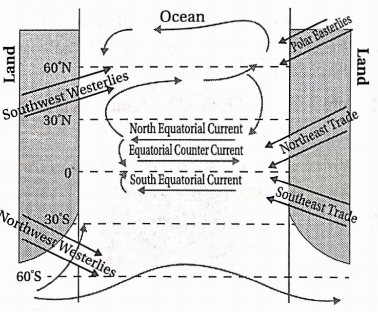
1. Wind: The planetary wind tends to generate currents in the water of the oceans over which they blow. They push the water in the direction as they blow.
Example— In regions under the influence of trade winds, the ocean currents flow from the east towards the west, and in regions under the influence of westerlies, the ocean currents flow from the west towards the east. In this way, new ocean currents originate.
Read and Learn Also WBBSE Solutions for Class 10 Geography and Environment
2. Difference in temperature in oceans: The ocean water in the equatorial and tropical regions is warm and leads to high rates of evaporation. This warm water is lighter and flows towards the polar regions as surface currents. In order to fill up this vacuum, the cold and heavy water of the oceans in polar regions flows towards the equatorial region. This water is cold and heavy and flows as undercurrents through the deeper layers of the oceans.
3. Difference in salinity: The level of salinity in ocean waters is not uniform everywhere. The less saline water is lighter and flows as surface currents towards the more saline water. The more saline water, on the other hand, is heavier. It flows as undercurrents towards the less saline water in order to fill up the vacuum.
4. Rotation of the earth: The ocean currents cannot flow in a straight direction due to the rotation of the earth. According to Ferrel’s Law, the ocean currents are deflected towards the right in the northern hemisphere and towards the left in the southern hemisphere.
Example—The Gulf stream turns towards the right and gives rise to the North Atlantic current due to the rotation of the earth.
5. Location and shape of continents: The ocean currents follow the coastline of the continents as they flow. In many cases, if they are obstructed by the margin or tip of the continent or some islands, they may give rise to new ocean currents.
Example—The South Equatorial current is obstructed by the cape of St. Roch in Brazil, from where a new currency called the Brazil current originates.
6. Melting of ice: The melting of ice in some regions raises the level of water in the oceans. This water then tends to flow towards the regions with less water in order to maintain a balance. Thus ocean currents are generated.
Chapter 3 Geography Class 10 WBBSE
Question 2. Discuss the effects OR, What are the influence currents on human life?
Answer:
The influence of ocean currents on human life is as follows-
1. Ice’free ports: The warm currents help to keep the ports of higher latitudes ice-free even in winter. Example— The warm North Atlantic current keeps many Norwegian ports free from ice so that they can be used throughout the year.
2. Help in navigation: The warm currents flowing through the surface of the oceans make sailing ships easier. This also helps in saving fuel. Hence, ships prefer to follow routes along the path of warm ocean currents.
3. Influence on climate: The region lying adjacent to warm currents has a warm climate and the region lying adjacent to cold currents have a cold or cooler climate. Example—The cold Labrador current keeps the summers on the Newfoundland coast cool and the warm Kuroshio current keeps the western coast of Japan warm in winter.
4. Rainfall and snowfall: The air blowing over warm currents becomes warm and collects much water vapour. Thus, they cause heavy rainfall in the coastal areas. But, the air blowing over cold currents is cold and dry. They cause no rainfall but sometimes cause snowfall in higher latitudes.
For example— the Namib desert has formed near the southwestern coast of Africa in Namibia due to a lack of rainfall.
5. Rough weather: The regions where warm and cold currents meet experience dense foggy conditions and severe thunderstorms. This hampers the sailing of ships and flying of aeroplanes over the region.
6. Development of fishing grounds: A huge amount of plankton grow in regions where warm and cold currents meet. This help in the development of fishing grounds, as planktons are the favourite food of fishes. Example—Coastal regions of
Newfoundland and Japan.
7. Submerged bars: The icebergs moving with the cold currents melt when they meet the warm currents. Thus, the rocks, pebbles, clay, sand, etc., trapped within the icebergs get deposited on the continental shelves. These gradually accumulate and rise in height and leading to the formation of submerged sandbars. These develop as very good fishing grounds.
8. Danger of icebergs: The cold currents bring down icebergs along with them from high latitude to low latitude regions. These pose a threat to ships that sail along those routes. Example—The famous ship Titanic was wrecked due to a collision with a huge iceberg on its maiden voyage from Southampton to New York City in 1912.
Chapter 3 Hydrosphere Short Explanatory Answer Type Questions
Question 1. How many types of ocean currents are there? Describe them. OR, What is warm and cold currents? OR, What are surface currents and Undercurrents?
Answer:
Ocean currents are of two types-
- Warm currents and
- Cold currents.
1. Warm Currents: Ocean currents originating in the oceans of the torrid zone are warm and light. They flow through the upper part of the oceans, towards the cold polar regions. These are called warm currents or surface currents.
2. Cold Currents: As the warm currents move towards the polar region, a temporary vacuum is created. Cold and heavy water from the polar regions flows towards the torrid zone deep under the sea. These are known as cold currents or undercurrents. Example—Labrador Current.
Hydrosphere Definition for Students
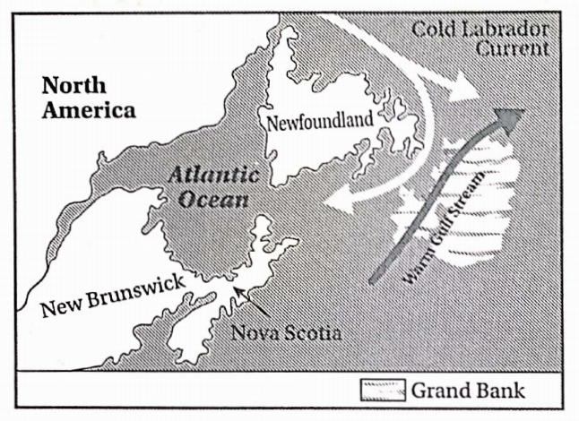
Question 2. Why has a submerged bar been formed in Newfoundland of North America?
Answer:
Newfoundland is located near the eastern coast of Canada. A number of submerged islands have been formed here, among which, the Grand Bank is the biggest.
Cause: The oppositely flowing cold Labrador Current (southward) and the warm Gulf Stream (northward) meet near Newfoundland.
- The icebergs coming down from the Arctic region with the cold Labrador Current melt here and the rocks, pebbles, clay and sand trapped within the icebergs get deposited. This goes on for ages and gradually some portion of the ocean rises quite high underneath the waters as submerged bars.
Chapter 3 Geography Class 10 WBBSE
Question 3. How are ocean currents generated? Or, What are the causes of the formation of ocean currents? Or, Why are Ocean Generated?
Answer:
Ocean currents can be generated by various factors. Planetary winds moving across an expanse of water move the surface of the water and produce ocean currents.
Warm areas of the ocean generate surface currents and from cold areas of the ocean, undercurrents are generated. High salinity generates undercurrents and low salinity generates surface currents. The projected ends of the continents and the position of the coastline in the path of a current generate new ocean currents. The upward or downward changes of the bottom relief of the ocean generate currents.
The earth’s rotation by deflecting moving ocean water generates ocean currents. The melting of ice changes the density of ocean water and helps to generate ocean currents.
Geography Chapter 3
Question 4. Why is Newfoundland a famous fishing ground? OR, Why is Grand Bank suitable for commercial fishing?
Answer:
Newfoundland is situated on the eastern coast of Canada. Two oppositely moving ocean currents, the cold Labrador Current (southward) and the warm Gulf Stream (northward) meet in this area.
Thus, icebergs melt and cause the deposition of rocks, pebbles, clay and sand to form huge submerged bars. Grand Bank is such a submerged bar, famous for commercial fishing for the following reasons—
Causes:
- The Grand Bank is about96,000sq. km in area and the depth of the water is about 15- 90m.
- The region lies in the temperate zone and has suitable climatic conditions (especially temperature) for the survival of fish.
- The meeting of the cold and warm currents leads to the growth of a huge amount of plankton, which is the favourite food of the fish.
- Various types of fish like cod, herring, mackerel, haddock, halibut, etc., crowd here in huge numbers due to the availability of plankton. Hence, commercial fishing can be done here
Question 5. Why are fishing grounds seen in the coastal areas of Japan?
Answer:
Japan is situated in the North Pacific Ocean. The warm Kuroshio Current and the cold Kuril Current meet near the eastern coast of Japan. Thus, the icebergs carried with the cold Kuril or Kamchatka Current melt as they come in contact with the warm Kuroshio Current.
The rocks, pebbles, clay, sand particles, etc., entrapped in icebergs get deposited near the coast on the continental shelf and form submerged bars. Here sunlight can reach the bottom of the seafloor and favour the growth of plankton, which is a favourite food of the fish. Thus, various kinds of fish crowd in this region and help in the development of fishing grounds.
Importance of Hydrosphere in Geography
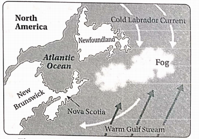
Question 6. Why Is dense fog seen on the eastern coast of Japan?
Answer:
In the oceans, wherever the warm currents and cold currents meet, the water vapour present in the warm air over the warm current comes in contact with the cool air over the cold current. Thus, the water vapour condenses into tiny droplets of water which remain suspended in the air and form dense fog.
In Japan, the warm Japan Current or Kuroshio Current moves northward, while the cold Kuril or Oyashio Current moves southward along the eastern coast. Thus, the meeting of these two warm and cold currents forms dense fog near the eastern coast of Japan.
Chapter 3 Geography Class 10 WBBSE
Question 7. Why does the coastal region of Newfoundland remain foggy throughout the year?
Answer:
In the oceans, where the warm currents and cold currents meet, the water vapour, present in the warm air over the warm current comes in contact with the cool air over the cold current. Thus, the water vapour condenses into tiny droplets of water which remain suspended in the air and form dense fog.
Along the coast of Newfoundland, the warm Gulf Stream moves towards the north and the cold Labrador Current moves towards the south. The meeting of these two opposite currents creates dense foggy conditions throughout the year.
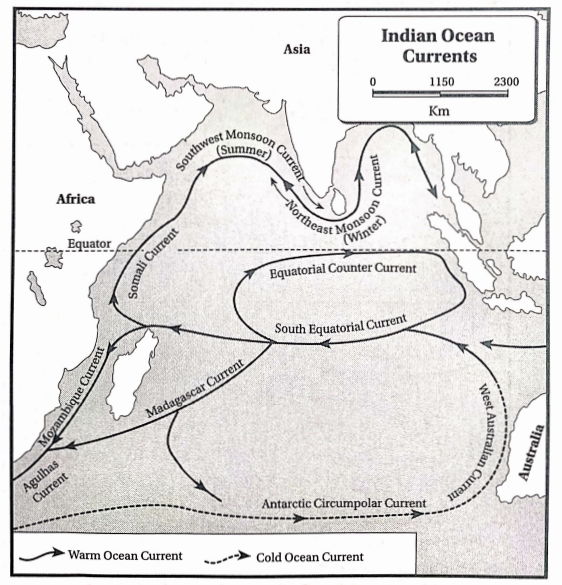
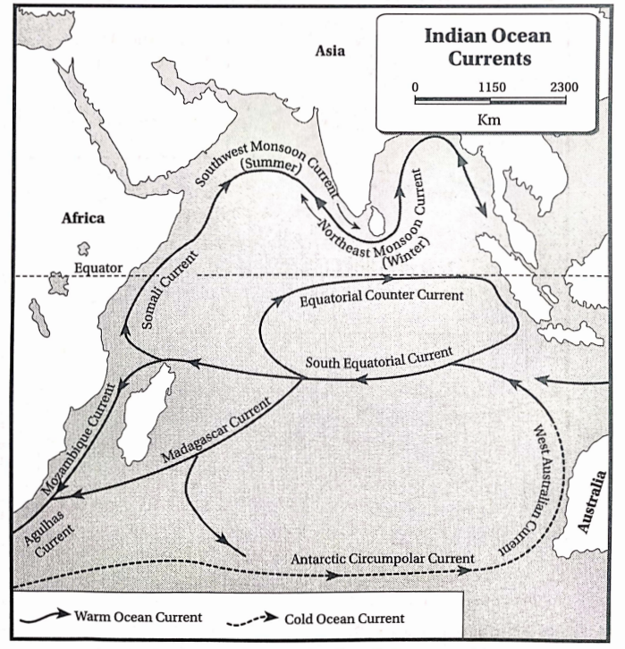
Question 8. Describe the ocean currents flowing through the northern part of the Indian Ocean during summer.
Answer:
The ocean currents flowing through the northern part of the Indian Ocean during summer
The Indian Ocean has two oppositely moving ocean currents in the summer and winter seasons. The branch of the South Equatorial current that enters the Indian Ocean follows the direction of the monsoon winds and hence is known as the monsoon current.
During summer, under the influence of the southwest monsoon winds, the current moves towards the right along the eastern coast of Africa.
It flows as the Somali Current in the north-eastern direction. Later, the current flows through the Arabian Sea and Bay of Bengal as the South-west Monsoon Current up to Sumatra.
Question 9. What is a “hydrosphere or Write About Hydrosphere?
Answer:
Hydrosphere:
About 71% of the earth’s surface is covered with water. Water bodies like lakes, ponds, rivers, oceans, gulfs, etc., make up the total water contained on the earth. This is known as the hydrosphere. The oceans are the largest water bodies on the earth. Ocean water flows from one region to another through ocean currents. This controls the climate of the region to a great extent.
Chapter 3 Geography Class 10 WBBSE
Question 10. How are the ocean currents named?
Answer:
Ocean currents are named according to the regions they cross and the seas or gulfs they flow through. For example- the Caribbean Current is so named as it flows through the Caribbean sea; the Brazil Current is so named as it passes along the coast of Brazil.
Question 11. Why is the climate of New York colder than that of London, in spite of New York lying at a lower latitude than London?
Answer:
London lies at 51°30’26″N latitude and New York lies at 40°43’N latitude. Under normal conditions, London should have a colder climate than New York, as it lies at a higher latitude than New York. However, it is seen that the climate of New York is colder than that of London. This is because of the influence of ocean currents.
The cold Labrador Current passes near New York and makes the climate cold. On the other hand, the warm North Atlantic current flowing west of London makes the climate of the city warm.
Question 12 How do ocean currents cause changes in climatic conditions?
Answer:
Ocean currents cause changes in climatic conditions in the following ways-
- Control on temperature: The warm currents move towards the polar regions from the equatorial region, and the cold currents flow towards the equatorial region from the polar region. This helps in maintaining a balance between the temperatures of various places, due to the exchange of heat.
- Rainfall and snowfall: The regions along which warm currents flow experience heavy rainfall. The regions along which cold currents flow are more prone to snowfall than rainfall.
- El Nino and La Nina: During El Nino, a warm current flows from the north towards the coast of Peru and Ecuador in South America. This causes heavy rainfall in those regions.
However, the chances of droughts increased in India and Australia. During La Nina, opposite climatic conditions prevail. Australia experiences heavy rainfall, India experiences moderate rainfall and Peru and Ecuador experience droughts.
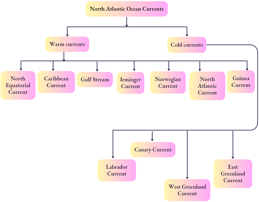
Question 13. Name the ocean currents of the North Atlantic Ocean
Answer:
The main ocean currents of the North Atlantic Ocean are-
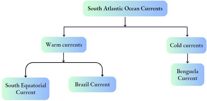
Question 14. Name the different ocean currents of the South Atlantic Ocean,
Answer:
The main ocean currents of the south Atlantic Ocean are-
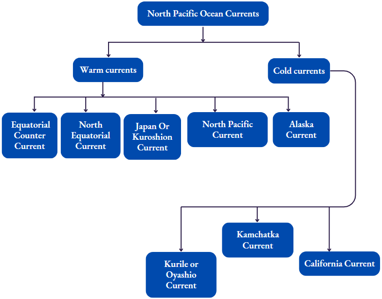
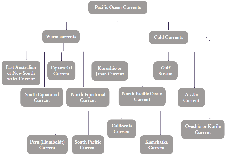
Question 15. Name the ocean currents of the North Pacific Ocean
Answer:
The main ocean currents of the North Pacific Ocean are
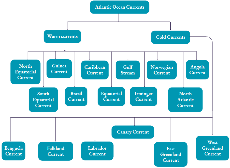
Question 16. Name the different ocean currents flowing through the Atlantic Ocean.
Answer:
The different ocean currents flowing through the Atlantic Ocean are—
Question 17. Name the main currents of the Pacific Ocean.
Answer:
The main ocean currents in the Pacific Ocean are-
Chapter 3 Geography Class 10 WBBSE
Components of the Hydrosphere
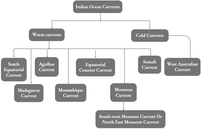
Question 18. Name the warm and cold currents of the Indian ocean.
Answer:
The warm and cold currents of the Indian Ocean are-
Water Cycle Explained Simply
Question 19. Differentiate between ocean currents and ocean waves.
Answer:
The differences between ocean currents and ocean waves are as follows-
| Point of difference | Ocean currents | Ocean waves |
| Direction | Ocean currents move in a single direction through the upper layers or the surface of the oceans. | Ocean waves are the upward and downward movement of the column of water on the surface. They do not have any direction of flow. |
| Duration | Ocean currents flow regularly and permanently in one direction. | Waves are periodic and uncertain. They depend on wind speed and direction. |
| Temperature | Ocean currents are of two types-warm currents and cold currents. | Waves cannot be divided according to temperature differences. |
| Influence | Ocean currents influence the climate of the coastline and nearby places along which they flow. | Waves only influence the ocean water surface where they occur. |
| Production of Energy | Energy production from ocean currents is at an early stage of development. | Wave energy is being produced in UK and Portugal. |
Chapter 3 Hydrosphere Short Answer Type Questions
Question 1. How many oceans are there in the world? Name them.
Answer:
There are five oceans in the world.
They are—
- Pacific Ocean,
- Atlantic Ocean,
- Indian Ocean,
- Arctic Ocean and
- Antarctic Ocean.
Question 2. What is the Gulf Stream?
Answer:
Gulf Stream:
In the Atlantic Ocean, the northern branch of the South Equatorial Current (warm current) and the North Equatorial Current (warm current) meet together and move westwards towards the Gulf of Mexico under the influence of the trade winds. This current is known as the Gulf Current or the Gulf Stream.
Characteristics:
- This is a warm current.
- The Gulf Stream appears blue in colour.
- The average temperature is about 27°C.
- The ocean current is 800-1200 m deep, 100 km wide and 65 km long. It moves at a maximum speed of 9 km/hr.
Class 10th Geography Chapter 3
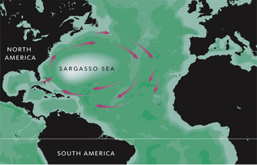
Question 3. What is the Sargasso Sea? OR, How is the Sargasso Sea formed?
Answer:
Sargasso Sea
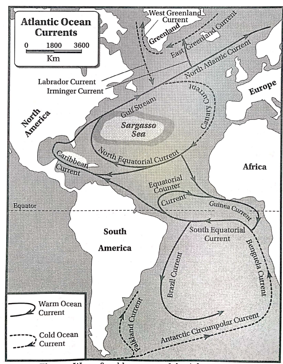
In the north Atlantic Ocean, a large portion of the water is encircled by the Gulf Stream in the west, North Atlantic Current in the north, the Canary current in the east and the North Equatorial current in the south.
This region is absolutely calm with no currents and flow. The water is stagnant and a huge amount of seaweeds, mosses and other aquatic plants grow here. Thus, this region is called the Sargasso Sea.
Question 4. What is an ocean current?
Answer:
ocean current:
The stream of water that flows from one place to another, regularly within the ocean itself, is called an ocean current. Ocean currents are of two types—warm currents and cold currents.
Freshwater vs. Saltwater Distribution
Question 5. What do you mean by the ‘cold wall’?
Answer:
‘Cold wall’
In North America, along the eastern coast, the warm Gulf Stream flows towards the north and the cold Labrador Current flows towards the south side by side. The division between the blue waters of the Gulf Stream and the green waters of the Labrador Current can be seen from far away for a long distance. This is known as the ‘cold wall’. This is not related to the height of the water column at the meeting point of these two ocean currents.
Question 6. How are submerged sandbars created?
Answer:
At places where the warm and cold currents meet, the icebergs coming with the cold currents melt as they come in contact with the warm currents. Thus, the rocks, pebbles, sand and clay present in icebergs get deposited on the continental shelf of the oceans. With regular depositions, the height of the shallow ocean floor starts rising gradually.
When it reaches such a height that it appears as a landform submerged a little below sea level, it is called a submerged sandbar submerged bar. Example—Grand Bank near the coast of Newfoundland, Dogger’s Bank near the British Isles.
Question 7. Which ocean current is known as the Labrador current?
Answer:
The Labrador Current is a cold current flowing through the North Atlantic Ocean. It originates from the Arctic Ocean and flows southwards between Greenland and Canada (i.e., the western coast of Greenland) and passes around Newfoundland and moves further southwards. This ocean current is a continuation of the West Greenland Current and the Baffin Island Current.
Question 8. Which ocean current is known as the Brazil current?
Answer:
In the Atlantic Ocean, the South Equatorial Current moves westwards and gets obstructed by the cape of St. Roch in Brazil. Here the current bifurcates into two branches, and the southern branch is known as the Brazil current.
Question 9. Which is the Peru or Humboldt Current?
Answer:
The Peru or Humboldt Current flows through the Southern Pacific Ocean. This cold current originating under the influence of the westerly winds moves eastwards and gets obstructed by the western coast of South America. Then, it moves northwards along the coast of Peru after crossing Chile.
Question 10. Which is the Japan or Kuroshio Current?
Answer:
The Japan current or the Kuroshio current is an important warm current flowing through the North Pacific Ocean. The west-flowing North Equatorial Current originates in the Pacific Ocean under the influence of the South-east trade winds. This current moves northwards along the eastern coast of Japan, where it is known as the Japan current or the Kuroshio current.
Question 11. Which is the Benguela Current?
Answer:
The Benguela Current is a cold current flowing through the Atlantic Ocean. In the Antarctic Ocean, the cold Antarctic Current originates, which moves eastwards under the influence of the westerlies. This current gets obstructed by the southwestern coast of Africa and moves northwards parallel to the western coast of Africa. Here, it is known as the Bengueia Current.
Effects of Pollution on Hydrosphere
Question 12. What do you mean by the monsoon current?
Answer:
Monsoon current
Monsoon currents are ocean currents generated in the northern part of the Indian Ocean due to the influence of the monsoon winds. These currents flow in opposite directions during the summer and winter seasons. During summer, the current flows under the influence of the South-west monsoon winds.
It moves in a circular path from the right side along the eastern coast of Africa through the Arabian Sea and the Bay of Bengal and flows up to the island of Sumatra. During winter, the current flows under the influence of the northeast monsoon winds. It moves in the opposite direction, i.e., in a circular motion from the left side.
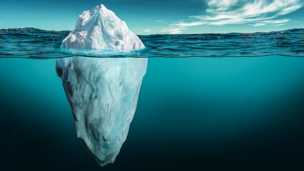
Question 13. What are icebergs?
Answer:
Icebergs:
The small and large floating hills of ice found in the oceans are called icebergs. Only the l/9th part of an iceberg remains above the ocean surface and the rest remains submerged in water. The famous ship called ‘Titanic’ sank after colliding with a huge iceberg on its maiden voyage.
Question 14. What do you mean by gyre?
Answer:
Gyre
If the movement of ocean currents in all the oceans is carefully looked at, a common pattern emerges. The water, in all oceans, has a circular motion.
This is known as a gyre. ‘Gyre’ is of two types—
- Sub-tropical gyre and
- Subpolar gyre.
In both the hemispheres between 25°-30° latitudes, the trade winds and the westerlies influence the ocean water to move around the subtropical high-pressure belt in a circular path.
Question 15. What are undercurrents?
Answer:
Undercurrents
The cold, dense and heavy water from the polar regions gradually flow towards the lower latitudes or the torrid zone. The water moves through the deeper layers of the sea. These are called undercurrents.
Question 16. What are surface currents?
Answer:
Surface currents
The ocean currents generated in the torrid region or the warm region of the earth are warm, less dense and light. Thus, they flow in the upper part i.e., near the ocean surface. These are called surface currents.
Question 17. Why are fish found in huge quantities near the coast of Japan?
Answer:
The cold Kamchatka or Oyashio Current and the warm Kuroshio Current meet near the eastern coast of Japan. The icebergs brought in by the cold current melt after coming in contact with the warm current. Thus, the gradual deposition of rocks, pebbles, clay and sand particles creates submerged sandbars. These submerged bars are ideal places for the growth of plankton, the nutrient-rich food of the fish. Hence, huge quantities of fish are found near the eastern coast of Japan.
Water Resources
Chapter 3 Hydrosphere Multiple Choice Type Questions MCQ Type
Write The Correct Answer From The Given Alternatives
Question 1. The cold wall is seen in—
- Atlantic Ocean
- Antarctic Ocean
- Indian Ocean
- Pacific Ocean
Answer: 1. Atlantic Ocean
Question 2. Which of the following currents flows along the eastern coast of Madagascar?
- Somali
- Madagascar
- Agulhas
- South-west monsoon
Answer: 2. Madagascar
Question 3. Which of the following is a warm current?
- Kamchatka
- Peru
- Brazil
- West Australian
Answer: 3. Brazil
Question 4. Ocean currents are generated due to the—
- Difference in temperature
- Difference in salinity
- Movement of planetary winds
- All the above are correct
Answer: 3. Movement of planetary winds
5. The ocean current flowing along the southwestern coast of South America towards the north is—
- Falkland current
- Humboldt current
- New South Wales’s current
- California Current
Answer: 2. Humboldt current
Question 6. The speed of ocean currents in shallow seas compared to deep seas is—
- More
- Less
- Not affected
- Remains same
Answer: 1. More
Question 7. Which of the following is a warm current flowing through the Gulf of Mexico?
- North Equator current
- North Atlantic Current
- Gulf stream
- South-west monsoon current
Answer: 3. Gulf stream
Question 8. The Peru current flows through the—
- Indian Ocean
- Atlantic Ocean
- Arctic Ocean
- Pacific Ocean
Answer: 3. Arctic Ocean
Question 9. Grand Bank is a—
- Warm Current
- Cold Current
- Submerged bar
- Island
Answer: 3. Submereged bar
Question 10. The Sargasso Sea is seen in the—
- Atlantic Ocean
- Indian Ocean
- Antarctic Ocean
- Arctic Ocean
Answer: 1. Atlantic Ocean
Question 11. The current which flows along the western coast of Madagascar is—
- Somali current
- Madagascar Current
- Mozambique current
- Agulhas current
Answer: 3. Mozambique’s current
Question 12. The largest and deepest ocean is the—
- Pacific Ocean
- Atlantic Ocean
- Indian Ocean
- Arctic Ocean
Answer: 1. Pacific Ocean
Question 13. In which ocean has the Sargasso Sea formed by four currents forming an ocean gyre?
- Pacific Ocean
- Atlantic Ocean
- Indian Ocean
- Antarctic Ocean
Answer: 2. Atlantic Ocean
Question 14. Dense fog occurs near Newfoundland due to—
- Meeting of Canary current and Gulf stream
- Meeting of Gulf stream and Labrador’s Current
- Meeting of Gulf stream and Equatorial current
- Meeting of Gulf stream and North Atlantic current
Answer: 2. Meeting of Gulf stream and Labrador Current
Question 15. A floating chunk of ice is called—
- Ice wall
- Snow line
- Iceberg
- Snowfield
Answer: 3. Iceberg
Question 16. The eastern coast of Japan remains warm even in winter due to the—
- Bering current
- Gulf stream
- Kuroshio current
- North-east monsoon current
Answer: 3. Kuroshio’s current
Question 17. The monsoon winds control the—
- Pacific Ocean currents
- Indian Ocean currents
- Atlantic Ocean currents
- Arctic Ocean currents IB,
Answer: 2. Indian Ocean currents
Question18. The largest number of ships sail on the—
- South Indian Ocean
- North Pacific Ocean
- South Atlantic Ocean
- North Atlantic Ocean
Answer: 4. North Atlantic Ocean
Question 19. Ocean currents are created by—
- Rotation of the earth
- Revolution of the earth
- Gravitational force
- None of these
Answer: 1. Rotation of the earth
Question 20. The maximum speed of the Gulf stream is—
- 5 km/hr
- 9 km/hr
- 15 km/hr
- 20 km/hr
Answer: 2.9 km/hr
Question 21. The Gulf stream appears—
- Deep green
- Deep red
- Deep blue
- Light violet
Answer: 3. Deep blue
Question 22. Tidal bores are seen in—
- River Yamuna
- River Ichamati
- River Hooghly
- River Ajay
Answer: 3. River Hooghly
Question 23. The ocean currents of the northern Indian Ocean are controlled by the—
- Trade winds
- Planetary winds
- Local winds
- Monsoon winds
Answer: 4. Monsoon winds
Question 24. The California current flows through the Ocean.
- Atlantic
- Indian
- Pacific
- Arctic
Answer: 3. Pacific
Question 25. The area of total surface covered by water on the Earth’s surface is near—
- 61%
- 81%
- 71%
- 91%
Answer: 3.71%
Question 26. The merging of the cold Labrador Current and warm Gulf Stream Current creates dense fogs and stormy weather conditions along—
- Newfoundland Coast
- Guinea Coast
- Florida Coast
- Peru Coast
Answer: 1. Newfoundland Coast
Chapter 3 Hydrosphere If The Statement Is True, Write T And If False, Write False Against The Following
Question 1. The Sargasso Sea has no currents.
Answer: True
Question 2. The warm Gulf stream appears deep blue in colour.
Answer: True
Question 3. The Grand Bank is situated in the Pacific Ocean.
Answer: True
Question 4. Fog and inclement weather are created at the meeting point of warm and cold currents.
Answer: False
Question 5. Kuroshio current is a warm current.
Answer: True
Question 6. California current is a cold current.
Answer: True
Question 7. The Sargasso Sea is seen in the Indian Ocean.
Answer: False
Question 8. Grand Banks are famous for commercial fishing.
Answer: True
Question 9. The main cause behind the origin of ocean currents is planetary winds.
Answer: True
Question 10. A thick wall of ice is seen at the cold wall.
Answer: False
Question 11. Foggy weather persists near the cold wall.
Answer: True
Question 12. The cold ocean current is also called the surface current.
Answer: False
Question 13. Drought occurs along the east coast of the Pacific Ocean under the influence of la nina.
Answer: True
Chapter 3 Hydrosphere Fill In The Blanks With Suitable Words
Question 1. The warm ______ current keeps the east coast of Japan warm in winter.
Answer: Kuroshio
Question 2. ______ is the largest ocean in the world.
Answer: Pacific ocean
Question 3. ______ is created at the meeting points of warm and cold currents.
Answer: Fog
Question 4. ______ forms where the warm Gulf stream and the cold Labrador current meet.
Answer: Cold wall
Question 5. The cold ______ current flows through the Arctic Ocean towards the coast of Japan.
Answer: Kamchatka
Question 6. The cold ______current flows along the eastern coast of South America towards the north.
Answer: Falkland
Question 7. Waves are______ the movement of water on the surface of the oceans.
Answer: Up and Down
Question 8. The water in oceans always moves from the equatorial region towards the______
Answer: Poles
Question 9. ______ per cent of the earth’s surface is occupied by oceans.
Answer: 71
Question 10. The presence of water on the earth’s surface gives it the name______
Answer: Blue Planet
Question 11. The heavy saline water flows as ______
Answer: Undercurrent
Question 12. The average speed of ocean currents is______
Answer: 5-10km/hr
Chapter 3 Hydrosphere Answer In One Or Two Words
Question 1. What is the movement of ocean water from one place to another called?
Answer: Ocean currents.
Question 2. What is the upward and downward movement of ocean water called?
Answer: Ocean waves.
Question 3. What are the waves splashing on the coast of oceans called?
Answer: Swash.
Question 4. What are the waves retreating from the coastline into the ocean water called?
Answer: Backwash.
Question 5. What are the backwash waves also known as?
Answer: Destructive waves.
Question 6. What are the small waves that help to form the coast called?
Answer: Constructive waves.
Question 7. What are the ocean currents flowing through the outer part of the oceans called?
Answer: Surface currents.
Question 8. What are the ocean currents flowing through the interior or deep layers of the oceans called?
Answer: Undercurrents.
Question 9. Which is the main controlling factor of ocean currents?
Answer: Planetary winds.
Question 10. In which direction do the warm currents flow?
Answer: From the equator towards the poles.
Question 11. In which direction do the cold currents flow?
Answer: From the poles towards the equator.
Question 12. Name a submerged bar in the Atlantic Ocean.
Answer: Grand Bank.
Question 13. Which hemisphere has the maximum volume of water bodies?
Answer: Southern hemisphere.
WBBSE Class 10 Geography Chapter 3 Question Answer
Question 14. Name the deepest ocean in the world.
Answer: Pacific Ocean.
Question 15. Which winds control the ocean currents of the northern part of the Indian Ocean?
Answer: South-west and northeast monsoon winds.
Question 16. The currents of which ocean are influenced by the monsoon winds?
Answer: Indian Ocean.
Question 17. In which ocean Sargasso Sea is seen?
Answer: Atlantic Ocean.
Question 18. Name the deepest ocean trench in the world.
Answer: Mariana trench.
Question 19. What is the stagnant water within an ocean, where seaweeds grow called?
Answer: Sargasso Sea.
Question 20. Which two currents combine to form the Agulhas current?
Answer: Mozambique current and Madagascar current.
Question 21. Name an ocean current of the Atlantic Ocean.
Answer: Benguela current.
Question 22. What is the main food of marine fish?
Answer: Plankton.
Chapter 3 Hydrosphere Match The Left Column With The Right Colum
1.
| Left Column | Right Column |
| 1. Kuroshio’s current | A. Greenland coast |
| 2. Labrador Current | B. Japan coast |
| 3. Canary current | C. Kamchatka coast |
| 4. Humboldt current | D. Portugal coast |
| 5. Kamchatka’s current | E. Peru coast |
Answer: 1-B,2-A,3-D,4-E,5-C
2.
| Left Column | Right Column |
| 1. Newfoundland | A. Cold Current |
| 2. East coast of Japan | B. the Largest number of ships pass |
| 3. Labrador coast | C. Submerged sandbar |
| 4. Coast of Brazil | D. Warm Current |
| 5. North Atlantic Ocean | E. Ice-free in winter |
Answer: 1-C,2-E,3-A,4-D,5-B
Chapter Hydrosphere Topic 2 Tides Long Answer Type Questions
Question 1. Explain the reasons or causes of tides. OR, How are tides formed?
Answer:
Reasons or causes of tides.
The swelling and falling of the ocean waters at regular intervals is known as tides. The tides are formed due to the following factors—
1. Attraction of the moon and the sun: According to this theory of Newton, each and every matter in the universe that has mass, attracts each other. Hence, there is an attraction between the sun, moon and the earth. The attraction of the moon is greater than the attraction of the sun on the earth.
This is because, although the sun is about 2 crore 70 lakh times larger than the moon, it is about 400 times farther away from the earth than the moon.
Thus, the attraction of the moon in forming tides is much more effective than the attraction of the sun. The sun also helps to form tides, but the tides formed by the moon are much more intense.
But, it should be noted that, when the sun, moon and earth lie approximately in a straight line, the tides formed are the most intense.
The tide formed on the side facing the moon is known as the primary tide. The tide formed on the opposite face of the primary or direct tide is known as the secondary or indirect tide.
While the tides are high in these two locations, the water level at the locations perpendicular to them falls. Hence, these locations experience ebb tides or low tides.
WBBSE Class 10 Geography Chapter 3 Question Answer
2. Centrifugal force developed due to the rotation of the earth: The earth is rotating on its axis continuously. This creates a centrifugal force, which tends to throw out moving bodies like air and water from the surface of the earth.
This force acts in the direction opposite to the force of gravity. Thus water seems to rise at places due to the centrifugal force.
Reservoirs of Water on Earth
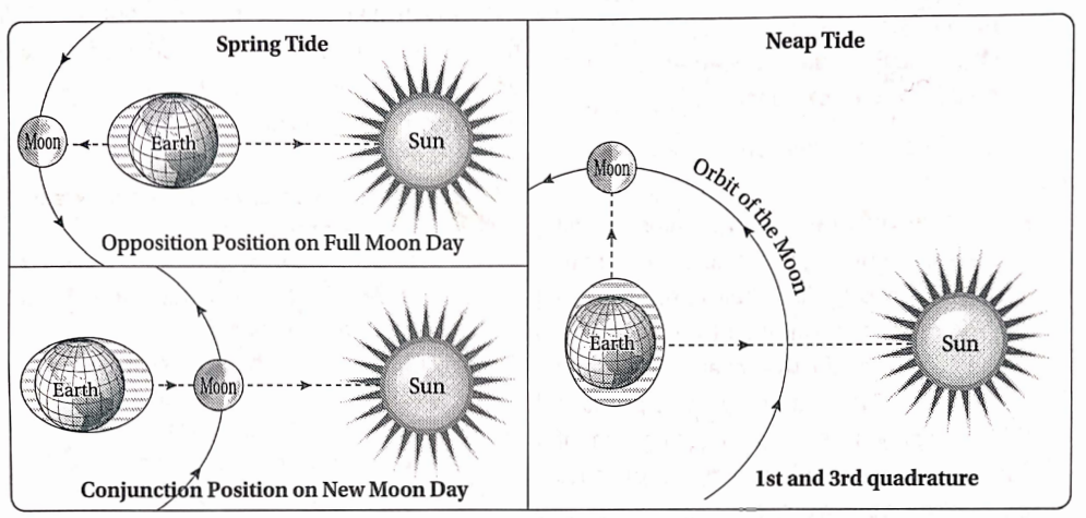
Question 2. How are spring tides and neap tides caused? OR, Discuss the formation of spring tides and neap tides. OR, What do you mean by spring tides? How do they occur? OR, Why do spring tides always occur on the new moon and full moon days?
Answer:
Spring tides: During the full moon, the earth lies in between the sun and the moon in a straight line. During the new moon, the moon lies in a straight line between the sun and the earth. On these two days, due to the combined attraction of the sun and the moon (especially on the new moon day), the water level rises to the maximum height possible. This is known as the spring tide.
1. New moon: The moon and the sun lie on the same side of the earth in a straight line on a new moon day. Thus, the attraction powers of the sun and the moon combine together and pull the water of the oceans from the same side. Hence, the tide occurring on the side facing the moon is the maximum compared to the tide on the opposite side.
2. Full moon: The earth lies in between the sun and the moon in a straight line on a full moon day. The sun and the moon lying on either side of the earth pull the water of the oceans from both sides. This creates high tides on either side, but the intensity is not as high as that on a new moon day.
3. Neap tides: During the first and third quarters of the moon, the sun and the moon lie at right angles to each other with respect to the earth. The power of attraction of the sun and the moon work at right angles to each other and hence cancel each other. Thus, the difference in the level of water during high tides and low tides is not much. This is known as a neap tide.
Neap Tide Diagram
Chapter Hydrosphere Short Explanatory Answer Type Questions
Question 1. How are the tides caused?
Answer:
The water in the oceans and seas rises and falls alternately at regular intervals. This up-and-down movement of the level of ocean water is known as tides.
What Is Tides In Geography
Causes: The main causes of tides are—
- The attraction of the sun and the moon.
- The centrifugal force is generated by the rotation of the earth.
Since the moon lies much closer to the earth compared to the sun, the attraction of the moon is much more effective in forming tides compared to the sun.
During rotation, when a side of the earth faces the moon, the water level of that side rises due
to the attraction of the moon. At the same time, the antipode of the place also experiences a rise in ocean water level due to the centrifugal force of the earth.
Thus, a primary or direct tide is generated in the first place, and an indirect or secondary tide is generated at its antipode.
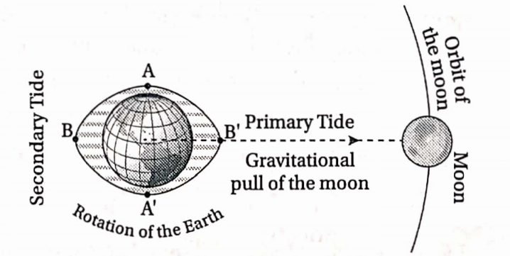
The places lying at right angles of these two places experience low tides at that time. The increase in water level due to the attraction of the moon and the centrifugal force draws away a huge quantity of water from the places lying at right angles. Thus, low tides or ebb tides are caused.
Question 2. Mention the effects of tides. OR, What are the effects of tides on human life? OR, Discuss the advantages and disadvantages of tides.
Answer:
The effects of tides on human life are discussed below:
1. Advantages of Tides: Large ships can sail into the rivers during high tides, and sail out during low tides. Tides help to remove the silt and other depositions of the river into the sea and keep the river channel deep and navigable. Tides can be used to produce tidal energy.
Tides help in the development of fishing activities as a huge amount of fish enters the rivers from the oceans during tides. The saline water of the oceans that enter the ports and rivers during high tides helps to keep the ports and river mouths ice-free during winters.
Geography Class 10 Chapter 3 WBBSE
2. Disadvantages of Tides: Tides make the river water saline which makes it unsuitable for agriculture, industrial activities or drinking.
The rise of water level during strong high tides often inundate agricultural fields and damage houses built near river banks.
Tides may damage water vessels like boats, launches, small ships, etc. Tides sometimes may lead to additional deposition of silt and other materials in the rivers brought in along with the ocean waters. This reduces the depth of the river channels.
What Is Tides In Geography
Question 3 Why are the spring tides known as the highest tides?
Answer:
Spring tides occur on the new moon and full moon days. During a new moon, the earth, sun and moon lie approximately in a straight line, and the moon lies in between the earth and the sun. During a full moon, the earth comes in between the sun and the moon when all three lie approximately in a straight line.
Compared to other days, the level of water during high tide rises much higher on the new moon and full moon days due to the double attraction of the sun as well as the moon. Thus, the spring tides are also known as the highest tides.
Question 4. What is the interval of time between a high tide and a low tide? OR, Why do high tide and low tide not occur at the same time at the same place every day? OR, Why is the interval between the primary and secondary tides of a place 12 hours and 26 minutes apart?
OR, Why do high tides and low tides occur twice at a place in one day? OR, Why is the time interval between two primary tides more than 24 hours? OR, Why is the time interval between two primary tides of a place 24 hours and 52 minutes?
Answer:
The moon takes about 27 – days to complete one revolution around the earth. When the earth completes one rotation around its axis in 24 hours, the moon moves ^th part of its orbit, i.e. [360° 4- 27 = 13] 13°. The earth takes more [4 x 13° = 52 min] 52 minutes to cover this distance.
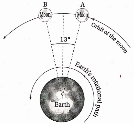
Hence, a particular place on the earth’s surface faces the moon once again after 24 hours and 52 minutes. Thus, primary tide occurs at the same place after 24 hours and 52 minutes. Secondary tide occurs after 12 hours 26 minutes at the place which experiences primary tide.
The places lying at right angles to the places experiencing high tides experience low tides. Thus, the time interval between a high tide and a low tide is 6 hours and 13 minutes.
Hydrological Cycle Processes
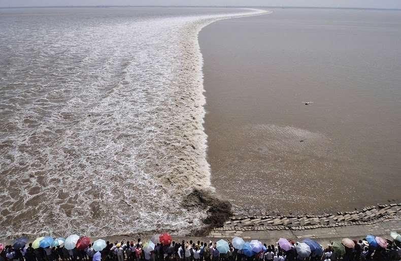
Question 5. What are tidal bores? OR, Write a short note on tidal bores,
Answer:
Tidal bores
During high tides, when the level of water in the oceans rises, the excess water flows into the rivers through the river mouth. This increases the level of water in the rivers as well. If the water enters with great speed and raises the water level by 5-7m, it is known as a tidal bore.
Favourable conditions for the occurrence of tidal bores are as follows—
- During springtides,
- If there are sandbars at the mouth of rivers,
- If the water is obstructed somehow while entering the river during high tides.
- If the shape of the mouth of the river is like a funnel.
- If the river is already filled with water to the banks.
Question 6. What are primary and secondary tides? Or, How are primary and secondary tides caused?
Answer:
Primary tide: Tides are caused due to the attraction of the moon and the sun and the centrifugal force developed due to the rotation of the earth. But, among these, the attraction of the moon is considered the main cause of the formation of tides.
During rotation, the side of the earth that faces the moon experiences a maximum rise in the water level during high tide due to the maximum attraction of the moon. This is known as the primary or direct tide.
Secondary tide: During a primary tide, the place lying at the antipode of the first place also experiences a high tide due to the centrifugal force of the earth. However, this tide is not as high as the primary tide. This is thus known as the secondary or indirect tide.
Question 7. What are spring tides and neap tides?
Answer:
Spring tides: During the new moon and full moon, the sun, earth and moon lie approximately in a straight line. Thus, the water level rises very high during high tides due to the combined attraction of the sun and the moon. These tides are known as spring tides.
Neap tides: During the first and third quarters of the moon, the sun and the moon lie approximately at right angles with respect to the earth. Thus, the attractions of the sun and the moon are countered by each other. This leads to a very low rise in water levels during the high tides. These tides are known as neap tides.
WBBSE Class 10 Geography Chapter 3 Question Answer
Question 8. Why is the primary tide caused on a new moon night more intense than the primary moon tide caused on a full moon night?
Answer:
During the full moon, the earth, sun and moon lie in a straight line and the earth lies in between the sun and the moon.The place of the earth that faces the moon, experiences primary tide due to more attraction of the moon and less attraction of the sun.
On the other hand, during the new moon, while the earth, moon and sun lie approximately in a straight line, the moon lies in between the earth and the sun. Now when a place on the earth faces the moon, it experiences a very high and intense tide due to the combined attraction of the moon and the sun from the same direction.
Thus, the intensity of primary tides on new moon nights is much more compared to that on full moon nights.
Question 9. Why is the swelling of water during a neap tide much less compared to the swelling of water during the spring tide?
Answer:
During the full moon and new moon, the sun, moon and the earth lie approximately in a straight line, and the spring tides are caused by the combined attraction of the sun and the moon. But during the first and third quarters of the moon, the sun and the moon lie approximately at right angles with respect to the earth.
They counter or oppose each other’s force of attraction. Hence, the tides caused at the places facing the moon are less intense and the swelling of water is less. These are known as neap tides when the swelling of water is much less compared to the swelling of water during the spring tides.
Question 10. Why do tidal bores occur in the river Ganga?
Answer:
The rushing in of water from the ocean into the river through the river mouth at great speed is known as a tidal bore. The level of water in the river may rise up to 5-7 m during a tidal bore.
The tidal bores in the river Ganga are caused due to the following reasons—
- The mouth of the river Ganga is like a funnel, i.e., the mouth is quite wide and open, but the river channel is comparatively narrow.
- There is a number of sandbars present near the mouth of the river Ganga.
- The river already remains filled with water during the rainy season.
- The water from the Bay of Bengal is obstructed by the river currents while entering the river channel.
Question 11. How do the tides influence the navigability of the rivers?
Answer:
The tides influence the navigability of rivers in the following ways—
Tides help to remove the silt and other materials from the river channels and increase the depth of the channels. This makes the rivers better navigable. The water level of rivers increases during high tides and helps large ships to enter the rivers.
The ships can leave the rivers and sail back to the ocean during low tides. Low tides help to remove silt and other materials from the river mouths and increase the depth of the channels.
Question 12. Differentiate between spring tide and neap tide.
Answer:
The differences between spring tide and neap tide are as follows-
| Point of difference | Spring tide | Neap tide |
| Concept | Occurs during the full moon and new moon when the sun, moon and earth lie approximately in a straight line. | Occurs during the first and third quarters of the moon when the sun and the moon lie approximately at right angles to each other with respect to the earth. |
| Force of attraction | Occurs due to the combined attraction of the sun and moon lying approximately in a straight line with the earth. | This occurs due to opposing powers of attraction of the sun and the moon lying approximately at right angles to each other. |
| Time of occurrence | Full moon and new moon. | First and third quarters of the moon. |
Question 13. Differentiate between Ocean currents and tides.
Answer:
The differences between Ocean currents and tides are as follows-
| Point of difference | Ocean currents | Tides |
| Concept | The flow of ocean water in one direction throughout the year from one region to another is due to various reasons. | The rise and fall of the level of ocean water during the day is due to various reasons. |
| Controlling factors | Wind, rotation of the earth, the temperature of ocean water, the salinity of ocean water, etc. | The attraction of the sun and moon, centrifugal force generated by the rotation of the earth. |
| Location | Ocean currents flow through all the oceans and have their effects on vast stretches of the oceans as well as on the landmass. | Tides influence only the coastal regions. |
| Effects | Formation of fishing grounds due to meeting of warm and cold currents; control over climate; keeping ports ice-free. | Entering of ships in rivers, keeping ports ice-free, navigation, influence on crops grown in coastal regions. |
Chapter 3 Hydrosphere Short Answer Type Questions
WBBSE Class 10 Geography Chapter 3 Question Answer
Question 1. What do you mean by tides?
Answer:
Tides:
The height of the ocean waters rises in some places and falls in other places alternately throughout the year. This is known as tides. Tides occur mainly due to the attraction of the moon, the attraction of the sun and the centrifugal force generated due to the rotation of the earth. Tides can be classified as high tides and low tides.
Question 2. What are tidal bores?
Answer:
Tidal bores
During the rainy season, when a spring tide occurs, water suddenly rushes back into the river channel due to a rise in the level of water in the ocean. This is known as a tidal bore. During tidal bores, the water may rise up to 6-8m and flow with great speed in the opposite direction of the flow of the rivers. The water flows with a roaring sound during the tidal bores.
Question 3. Mention the two main causes of tides.
Answer:
The main causes of tides are-
- The gravitational pull of the moon and the sun.
- The centrifugal force is generated due to the rotation of the earth.
Question4. What do you mean by conjunction and opposition?
Answer:
Conjunction: The position where the earth, moon and sun lie approximately in a straight line with the moon lying in between, is known as a conjunction. This occurs on new moon days.
Opposition: The position where the earth, moon and sun lie in a straight line, with the earth lying in between, is known as opposition. This occurs on full moon days.
Question 5. What is ‘syzygy’?
Answer:
Syzygy
The position where the earth, moon and the sun lie approximately in a straight line is called ‘syzygy’. It can be classified into two types-
- Conjunction: When the moon lies in between the sun and the earth.
- Opposition: When the earth lies in between the sun and the moon.
- Effects: Syzygy causes very powerful tides. Thus spring tides occur on the full moon or new moon nights.
Question 8. What are lunar tides?
Answer:
Lunar tides
During the rotation of the earth. the side of the earth that comes in front of the moon faces its maximum gravitational pull. Thus. water in this region rises the maximum during high tides. These tides are known as lunar tides.
Question 7. What are solar tides?
Answer:
Solar tides
The swelling of water that occurs due to the attraction of the sun. is known as the solar tide. The attraction of the sun is much lesser than the moon due to the greater distance between the sun and the earth. Thus. the intensity of the solar tides is also less.
Question 8. What are springtides?
Answer:
Springtides
During the new moon and full moon. the sun. moon and the earth lie on the same straight line. This is known as syzygy. The tides formed during this time are called spring tides. Water rises maximum during these tides.
Question 9. What are neap tides?
Answer:
Neap tides
During the first or third quarter of the moon. the sun and moon lie perpendicular to each other with respect to the earth. The places on earth which face the moon and sun experience high tides. But. as the sun and the moon lie perpendicular to each other. both try to pull the water towards it. Thus. the tides do not become intense. These are known as neap tides.
Question 10. Why are spring tides also known as the highest tides?
Answer:
On the new moon and full moon days. the sun. moon and the earth lie in the same straight line. Especially. during the new moon. the moon comes in between the earth and the sun. The tides formed due to the combined attraction of the sun and the moon are the highest. Hence. such tides are known as the highest tides.
WBBSE Class 10 Geography Chapter 3 Question Answer
Question 11. What is the direction of the flow of water in tides?
Answer:
Direction of the flow of water in tides
The water in tides rises and falls in a particular direction due to the rotation of the earth. Thus. water moves from east to west during high tides. and moves in the direction from west to east during ebb tides.
Chapter 3 Hydrosphere Multiple Choice Type Questions [MCQ type]
Write the correct answer from the given alternatives
Question 1. Tides can be seen in rivers—
- Tista
- Sutlej
- Yamuna
- Hooghly
Answer: 4. Hooghly
Question 2. Saline water is—
- Light
- Heavy
- Warm
- Cold
Answer: 2. Heavy
Question 3. The part of the earth that faces the moon. experiences—
- Springtide
- Neap tide
- Primary tide
- Ebbtide
Answer: 1. Springtide
Question 4. High tides occur every 24 hours and 52 minutes.
- Once
- Twice
- Thrice
- Four times
Answer: 3. Thrice
Question 5. Neap tide occurs on—
- Full moon
- New moon
- First and third quarters of the moon
- The second day after the full moon
Answer: 3. First and third quarters of the moon
Question 6. Neap tides occur when the moon lies ____ to the sun.
- Perpendicular
- Parallel
- On the same line
- Opposite
Answer: 1. Perpendicular
WBBSE Class 10 Geography Chapter 3 Question Answer
Question 7. The time interval between two high tides is—
- 6 hr 13 min
- 12 hr 26 min
- 24 hr 52 min
- 24 hr 55 min
Answer: 3. 24 hr 52 min
Question 8. The moon revolves around the earth once in about—
- 27 days
- 29 days
- 30 days
- 28 days
Answer: 1. 27 days
Question 9. During the new moon. the side of the earth that faces the moon during daytime experiences—
- Springtide
- Neap tide
- Ebbtide
- None of these
Answer: 1. Springtide
Question 10. The mass of the sun compared to the moon is about—
- 25 million times greater
- 27 million times greater
- 52 million times lesser
- 15 million times greater
Answer: 2. 27 million times greater
Question 11. The attraction power of the moon over the earth compared to the sun is—
- 1.1 times greater
- 2.2 times greater
- 3.3 times lesser
- 5.5 times greater
Answer: 2. 2.2 times greater
Question 12. The centrifugal force causes—
- Secondary tides
- Primary tides
- Springtides
- Neap tides
Answer: 1. Secondary tides
Question 13. The antipode of the place facing high tides experience—
- Secondary tides
- Neap tides
- Solar tides
- Ebbtides
Answer: 1. Secondary tides
WBBSE Class 10 Geography Chapter 3 Question Answer
Question 14. The position of the sun, moon and earth on the same straight line is known as—
- Apogee
- Perigee
- Syzygy
- Aphelion
Answer: 3. Syzygy
Question 15. The sun is times heavier than the moon.
- 270 lakh
- 200 lakh
- 25 lakh
- 10 lakh
Answer: 1. 270 lakh
Question 16. The distance between the earth and the moon at perigee position is—
- 3 lakh 84 thousand km
- 3 lakh 63 thousand km
- 4 lakh 57 thousand km
- 3 lakh 76 thousand km
Answer: 2. 3 lakh 63 thousand km
Question 17. The upswelling of water during tides at Perigee compared to other positions is greater.
- 10%
- 20%
- 30%
- 40%
Answer: 2. 20%
18. Conjunction occurs during—
- Full moon
- New moon
- 7th day after the full moon
- 8th day after the new moon
Answer: 2. New moon
Geography Class 10 Chapter 3 WBBSE
Question 19. Duration of both high tide and low tide is near—
- 2 hours
- 6 hours
- 4 hours
- 8 hours
Answer: 2. 6 hours
Question 20. On the days of Neap Tides, the sun and the moon are at the following angles to each other in respect of the earth—
- 180°
- 360°
- 90°
- 120°
Answer: 3. 90°
Chapter 3 Hydrosphere If The Statement Is True, Write True And If False, Write False Against The Following
Question 1. The centrifugal force is the same all over the earth.
Answer: False
Question 2. The intensity of tides depends upon the location of the sun and the moon.
Answer: True
Question 3. The Tamil word ‘Kadal’ means high tides.
Answer: False
Question 4. Tides make the river water sweet.
Answer: False
Geography Class 10 Chapter 3 WBBSE
Question 5. The load in the rivers are cleared by the tides.
Answer: True
Question 6. High tides and low tides occur alternately at an interval of about 6 hrs.
Answer: True
Question 7. Tides help to generate thermal power.
Answer: False
Question 8. High tides and low tides occur twice each day.
Answer: True
Question 9. Neap tides occur on the full moon and new moon nights.
Answer: False
Question 10. Two primary tides occur at an interval of 24 hours.
Answer: False
Question 11. Solar tides are caused by the gravitational pull of the sun.
Answer: True
Question 12. Neap tides occur on a new moon.
Answer: False
Question 13. A syzygy occurs when the sun. moon and the earth lie on the same line.
Answer: False
Question 14. Tidal bores are common in river Hooghly during spring.
Answer: True
Question 15. The waves in the oceans move from west to east.
Answer: False
Question 16. Tides do not occur in the Mediterranean Sea.
Answer: True
Question 17. The water level in oceans increases during the new moon. and decrease during a full moon.
Answer: False
Question 18. Tidal waters do not rise more than 3-4 feet in regions lying between oceans and seas.
Answer: True
Question 19. The tidal bores in the river Hooghly damage ships sailing on it.
Answer: True
Geography Class 10 Chapter 3 WBBSE
Chapter 3 Hydrosphere Fill in the blanks with suitable words
Question 1. _____ tides occur in the direction towards which the rivers flow.
Answer: Ebb
Question 2. occurs due to rotation and_____ centrifugal force of the earth.
Answer: Secondary tides
Question 3. Spring tides occur in a place every_____ day.
Answer: 15
Question 4. When the water rises during high tides and rushes into the rivers in opposite direction. it is called _____
Answer: Tidal Bore
Question 5. The distance between the earth and the sun is_____ times greater than distance between the earth and the moon.
Answer: 391
Question 6. Secondary tides occur due to the _____ force.
Answer: Centrifugal
Question 7. Primary tides occur due to the attraction of the _____
Answer: Moon
Question 8. The fishes enter the rivers from the ocean during _____
Answer: High tides
Question 9.’Kadal’ means _____
Answer: Ocean
Geography Class 10 Chapter 3 WBBSE
Question 10. Neap tides occur on the _____ of the moon.
Answer: First and Third Quarters
Question 11. The syzygy position during the new moon is known as_____
Answer: Conjunction
Question12.Tides are used to produce _____ energy.
Answer: Tidal
Question 13. High tides and low tides occur _____ daily.
Answer: Twice
Question 14. Tidal bores occur frequently in _____ season.
Answer: Monsoon
Question 15. Tidal bores occur in a river during_____
Answer: High Tides
Question 16. The tides occurring due to the moon’s attraction are called _____
Answer: Lunar Tides
Question 17. The moon traverses_____ in one day on its orbit.
Answer: 13°
Question 18. Tides swell maximum during the_____
Answer: New moon
Question 19. The small sea waves that help to form the coast are called _____waves.
Answer: Constructive
Question 20. The open part of the sea is called_____
Answer: Fetch
Question 21. The _____ waves damage the sea coast.
Answer: Destructive
Question 22. During high tide, huge tidal waves entering _____ through the mouth of a river from the sea are called as
Answer: Tidal bore
Chapter 3 Hydrosphere Answer In One Or Two Words
Question 1. What percentage of the earth’s surface is covered with water?
Answer: 71%.
Question2. How much area of the earth’s surface is covered with water?
Answer: 36 crores. 17 lakh. 40 thousand sq. km.
Question3. What is the earth also known as due to the presence of 71% of the water on its surface?
Answer: Blue planet.
Question 4. What is the average distance between the moon and the earth?
Answer: 384.000 km.
Question 5. What is the main cause of tides?
Answer: The attraction of the moon and the sun.
Geography Class 10 Chapter 3 WBBSE
Question 6. What are tides formed due to the attraction of the moon called?
Answer: Lunar tides.
Question 7. What are tides formed due to the gravitational attraction of the sun called?
Answer: Solar tides.
Question 8. How many times do high tides occur in a region in a day?
Answer: Twice.
Question 9. What is the interval between two secondary tides?
Answer: 12hrs26mins.
Question 10. What is the interval between two consecutive primary tides?
Answer: 24 hrs 52 mins.
Question 11. Which seas do not experience tides?
Answer: Mediterranean sea. and Baltic sea.
Question 12. How much angle does the moon traverse in one day?
Answer: About 13°.
Question 13. What is the position of the earth? sun and the moon lying in a straight line called?
Answer: Syzygy.
Question 14. Name a river which is prone to the actions of the tidal bores.
Answer: River Hooghly.
Question 15. Which energy causes secondary waves?
Answer: The gravitational attraction of the sun.
Question 16. When do tidal bores occur?
Answer: During spring side.
Question 17.According to relative location. what is the physical location between the moon and the earth?
Answer: 4 lakh 05 thousand km. (According to NASA)
Question 18. Which tides are accompanied by tidal bores generated in the oceans?
Answer: Primary tides.
Question 19. What is the distance between the moon and the earth during perigee?
Answer: 3 lakh 60 thousand km. (According to NASA)
Question 20. What is the ratio of the moon and sun’s capacity to cause tides?
Answer: 11:5.
Question 21. What is the shape of the earth’s orbit?
Answer: Elliptical.
Geography Class 10 Chapter 3 WBBSE
Chapter 3 Hydrosphere Match The Left Column With The Right Column
1.
| Left Column | Right Column |
| 1. Opposition | A. New moon |
| 2. Perigee | B. Farthest distance between moon and earth. |
| 3. Conjunction | C. Sun, moon and earth lie in the same straight line. |
| 4. Apogee | D. Full moon |
| 5. Syzygy | D. Closest distance between the moon and the earth. |
Answer: 1-D,2-A,3-E,4-B,5-C