WBBSE Chapter 3 Air Pressure Long Question And Answers
Question 1. Explain the causes of variation in air pressure.
Answer:
Causes of variation in air pressure:
Air pressure varies from place to place on the Earth. The reasons are as follows-
1. Temperature of air:
With an increase in temperature, the molecules of air start moving apart from each other. So, the air expands, becomes lighter and rises up. It causes low pressure. On the other hand, the air pressure is higher for compressed air.
Therefore, air pressure increases when the temperature declines and air pressure decreases when the temperature rises.
2. Altitude:
Air is most dense near the surface of the Earth. The density of air decreases with an increase in altitude. The lesser number of air molecules at higher altitudes means fewer molecular collisions and a decrease in air pressure.
With a 110 m increase in altitude, air pressure decreases by 1cm of mercury column.
Read And Learn Also WBBSE Solutions For Class 7 Geography
3. Water vapour in the air:
A certain volume of humid air weighs less than an equal volume of dry air. Therefore, humid air is less dense and exerts lower pressure than dry air.
4. Rotation of the Earth:
The rotational speed of the Earth is not equal at all places. Near the Equator, the speed is maximum and it gradually decreases towards the Poles with a decrease in the Earth’s circumference.
Thus the air has a tendency to move outward in the equatorial region and to move inward in the polar region because of centrifugal and centripetal force respectively.
As a result, a low-pressure belt is found over the equatorial region and a high-pressure belt is found near the polar region.
5. Variation in land and water surface:
The land area absorbs more heat during the summer and becomes a low-pressure area. On the other hand, the same land easily cools down during the winter season and becomes a high-pressure area. Exactly the opposite happens in the case of a water body.

Question 2. Write down the characteristics of the high-pressure area and low-pressure areas.
Answer:
Characteristics of high-pressure area and low-pressure area:
The characteristics of high-pressure area are as follows-
1. Concept:
The region where the atmospheric pressure at the surface is higher than the surrounding environment is known as a high-pressure area.
2. Air temperature:
High-pressure areas are found in cooler regions, i.e. where the temperature remains low.
3. Formation:
High pressure develops due to descending nature of air. In cold regions, the air gets compressed resulting in high density and hence, pressure increases.
4. Weather conditions:
The weather remains calm and quiet (i.e. absence of clouds, rain, etc.) in high-pressure areas because of the low content of water vapour.
The characteristics of low-pressure area are as follows-
1. Concept:
The region where the atmospheric pressure at the surface is lower than the surrounding environment is known as a low-pressure area.
2. Air temperature:
Low-pressure areas are found in warm regions, i.e. where the temperature remains high.
3. Formation:
Low pressure develops due to ascending nature of air. In warm regions, the air becomes lighter and rises up, resulting in a low density of air near the surface and so pressure decreases.
4. Weather conditions:
Cloud formation, rain, storm and other weather phenomena are common in low-pressure areas due to the high water vapour content.
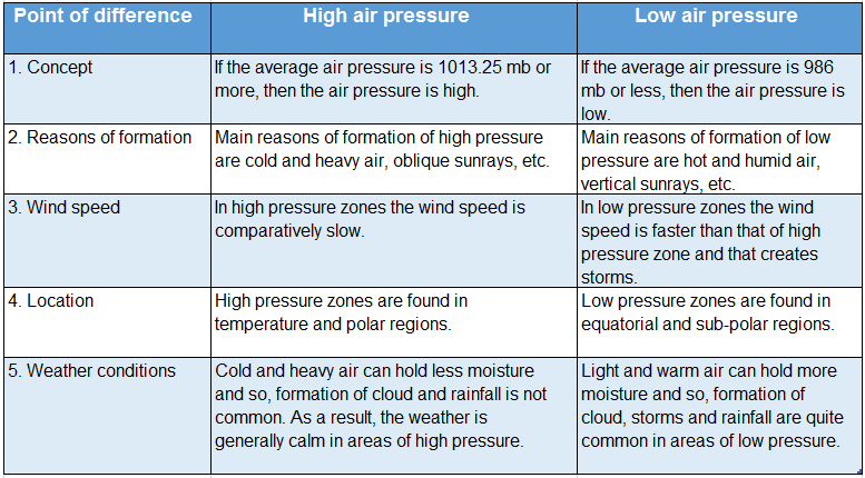
Question 3. Write the differences between high and low pressure of air.
Answer:
Difference between high and low pressure of air:
The following are the important differences between high air pressure and low air pressure.
Question 4. Describe an experiment for air pressure.
Answer:
An experiment for air pressure:
A plastic bottle is taken and filled ¾ with water. If we squeeze the bottle tightly, we will see that the shape gets distorted. If we remove the pressure, the bottle regains its original shape.
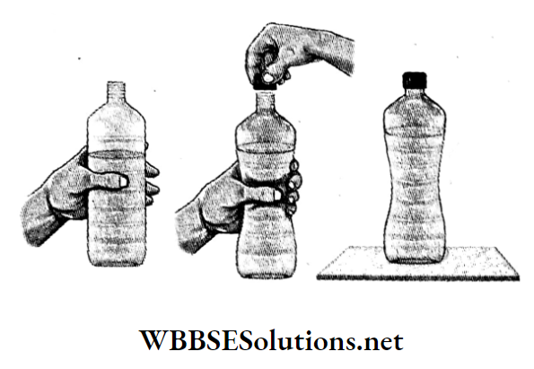
- Now, the mouth of the bottle is shut while squeezing the bottle. If we remove our hand now, we will see that the bottle remains in that state. The bottle does not regain its shape till it is uncapped again.
- This is because, when the bottle is squeezed, some air escape out and the pressure inside the bottle becomes less than the atmospheric pressure outside. Due to the higher atmospheric pressure outside the bottle, it does not regain its shape.
Question 5. Prove that air exerts pressure in the upward direction.
Answer:
Air exerts pressure in the upward direction:
The fact that air exerts pressure in the upward direction can be proved through the following experiment.
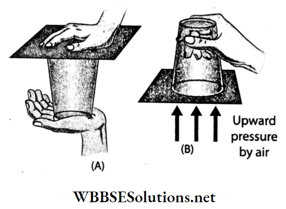
Procedure:
- A glass is filled with water to the brim. Now the glass top is completely covered with a postcard.
- Now the glass is quickly inverted after keeping the palm lightly on the postcard. Then slowly the hand is removed from the postcard.
Observation:
The postcard does not fall off even when the hand is removed from the inverted glass.
Inference:
The water in the glass exerts downward pressure and at the same time, the outside air exerts upward pressure on the postcard. The upward pressure of the air is much more than that of the downward water pressure and so, the postcard does not fall off.
Since the upward air pressure does not allow the postcard to fall off, hence, it is proved that air exerts upward pressure.
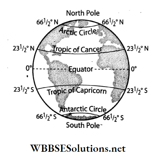
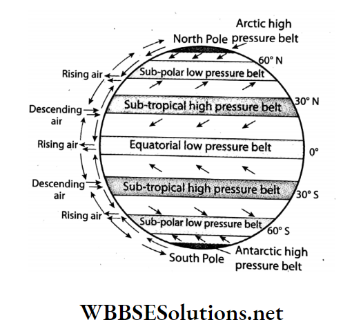
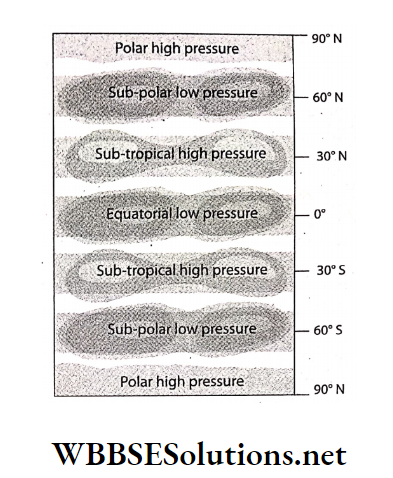
Question 6. Name the atmospheric pressure belts.
Answer:
Atmospheric pressure belts:
In some definite regions on the Earth’s surface, high pressure or low pressure is observed throughout the year. These definite regions of atmospheric pressure surround the Earth in the form of belts.
These are called atmospheric pressure belts. There are seven atmospheric belts on the Earth’s surface. These are-
- Equatorial low pressure belt (0° -5° north and south of the Equator),
- Sub-tropical high-pressure belt in the northern hemisphere (25° -35° north latitude),
- Sub-tropical high-pressure belt in the southern hemisphere (25°-35° south latitude),
- Sub-polar low-pressure belt near the Arctic circle in the northern hemisphere (60°-90° north latitude),
- Sub-polar low-pressure belt near the Antarctic circle in the southern hemisphere (60°-90° south latitude),
- Arctic high-pressure belt at the North Pole (90° north latitude), and
- Antarctic high-pressure belt at the South Pole (90° south latitude).
Question 7. Why is the atmospheric pressure less in the equatorial region?
Answer:
The atmospheric pressure is less in the equatorial regions due to the following factors-
1. High temperature:
The Equatorial region experiences vertical rays of the sun throughout the year. So the temperature is very high. It causes upward movement of air by the process of convection. Hot air is light so its pressure is low.
2. Excessive humidity:
The water area is more than the land area at the Equator, which leads to excess addition of water vapour in the atmosphere around this region. The air pressure of humid air is lower than dry air.
3. Highest rotational speed:
The highest rotational speed of the Earth at the Equator causes the deflection of wind. Thus low pressure prevails over the equatorial regions.
Question 8. What are atmospheric pressure cells?
Answer:
Atmospheric pressure cells:
There exists a difference in air temperature and air pressure between the land areas and the water areas.
- Sometimes these atmospheric pressure belts do not surround the Earth continuously in the east-west direction but get divided into small parts or regions. These small regions of air pressure are called pressure cells.
- The number of pressure cells is higher in the northern hemisphere than in the southern hemisphere as the latter has a continuous stretch of waterbody for an extensive area which leads to the formation of pressure belts rather than pressure cells over it.
Question 9. What do you mean by high pressure and low pressure?
Answer:
High pressure and low pressure:
Standard atmospheric pressure is 1013.25 MB. Air pressure, ranging between 986 mb-1013mb, is considered as normal air
pressure. If the average air pressure is more than 1013.25 mb, it is known as high pressure.
- When the air gets cooled and compressed, the density increases, i.e. the number of molecules in a specific volume of air increases and air pressure also increases, creating high pressure.
- If the average air pressure is less than 986 MB, it is known as low pressure. When the temperature of air increases, the molecules of air become dynamic and move apart from one another.
- As a result, the air gradually expands and becomes lighter and rises upwards, the density of air decreases, i.e. the number of molecules in a specific volume of air decreases and the air pressure also decreases, creating low pressure.
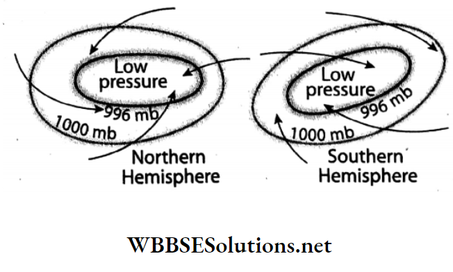
Question 10. Define a cyclone.
Answer:
Cyclone:
A cyclone is a system of winds around an area of low pressure surrounded by high-pressure areas.
- This is usually characterised by inward spiralling winds that rotate anti-clockwise in the northern hemisphere and clockwise in the southern hemisphere.
- These cyclonic winds bring heavy rain and cause huge loss of life and property in the areas over which they blow.
Question 11. Put some paper inside a tumbler so that it sticks to the bottom of the tumbler and does not fall off even when you turn the tumbler upside down. Now turn the tumbler upside down and immerse it in a big bucket of water. You would naturally expect the paper inside the tumbler to get wet, isn’t it?
Pull the tumbler out and check if the paper is wet. Now immerse the tumbler into a bucket full of water. This time the paper gets soaked.
Why doesn’t the paper get wet when the tumbler is immersed in an upside-down position? Think about it.
You can now challenge your friends to immerse the tumbler completely in a bucket full of water and still keep the paper dry!
Answer:
When the bottom of a tumbler is filled with rolled-up papers and immersed upside-down in a bucket full of water, it will be observed that some water flows into the tumbler.
- But till the time this water level reaches the papers, the papers will not get soaked. At this time, an upward thrust is felt on the tumbler.
- The tumbler was immersed in an upside-down position, so, some air remained trapped between the water level and the bottom of the tumbler.
- As more and more pressure is exerted on the tumbler, for it to immerse fully, the air trapped inside the tumbler gets compressed.
- So, the air pressure inside the tumbler increases with compression.
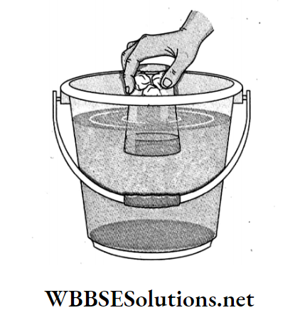
- This pressure gradually starts changing the shape of the paper inside the tumbler. So, if the tumbler is immersed partially and then removed, it will be observed that the papers do not get soaked.
- But instead of removing the tumbler, if more pressure is exerted on the tumbler to immerse it, then it will be observed that the papers would get soaked at a particular point.
- This particular point would be attained when the air pressure outside the tumbler becomes greater than the pressure inside the tumbler.
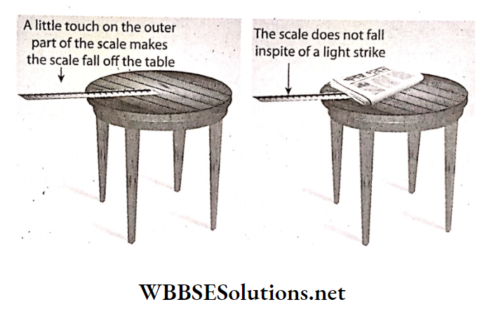
Question 12. Keep a scale at the edge of a table so that the greater part of the scale hangs outside. A little touch on the outer part makes the scale fall off the table. Now spread a newspaper over the part of the scale on the table and then lightly strike the outer part of the scale. See what happens now!
Answer:
First, as the major part of the scale was hanging outside the table, the air pressure acting on the part of the scale on the table top was very less.
- So, it will fall even with a small tap on its hanging edge.
- Now, when a newspaper is spread over the part of the scale on the table, the surface area on which the air pressure is acting on increases and the scale does not fall so easily.
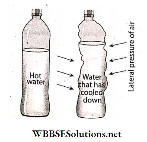
Question 13. A plastic water bottle is partly filled with nearly boiling water and the stopper is sealed. You will see that after some time the bottle gets crushed. What is the reason?
Answer:
A plastic water bottle is partly filled with nearly boiling water and kept for a few hours. After some time we will see that the bottle gets a little crushed.
- This is because as soon as the bottle is filled with hot water, the inside air heats up and goes out a bit.
- Then the water inside and the rest of the air slowly cool and compress, creating a vacuum inside the bottle.
- As a result, the air pressure inside the bottle is much lower than the outside air pressure.
- So the bottle gets crushed under the influence of lateral pressure of the outside air.
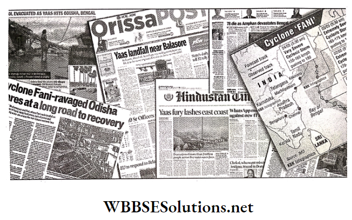
Question 14. Collect photographs and information about any storm in your district, state or country of the recent past from the newspapers and magazines. Make a collage with them. Paste it in your exercise book and show it to your friends in the classroom.
Answer:
Question 15. What are the effects of air pressure?
Answer:
The effects of air pressure are as follows-
1. Effect on the respiratory system:
As the pressure of air is very low at high altitudes, we need to breathe faster while climbing mountains. For this reason, mountaineers carry oxygen cylinders with them.
2. Effect on health:
At very high altitudes, where the air pressure is very low, the pressure of the blood molecules inside our body increases drastically and may result in bleeding from our ears, nose, eyes, etc.
3. Effect on weather conditions:
Severe cyclones and rain occur in intense low-pressure regions.
4. Effect on air:
Air pressure influences the direction of airflow, the temperature of the air, etc.
Question 16. Fill up the knowledge hive with information about barometers.
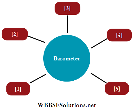
Answers:
1. This instrument is used to measure air pressure.
2. Torricelli invented the mercury barometer in the year 1643.
3. Barometers are of various types- Fortin’s, Aneroid, etc.
4. To ensure the accuracy of the reading of the mercury height, a vernier scale is attached to the top of the mercury column in a Fortin barometer.
5. Apart from measuring atmospheric pressure, it is also utilised for weather forecasts and measuring altitude.
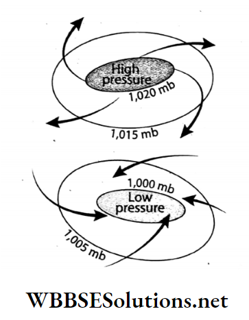
Question 17. Which of the following is a low-pressure and high-pressure diagram? Identify the direction of wind flow.
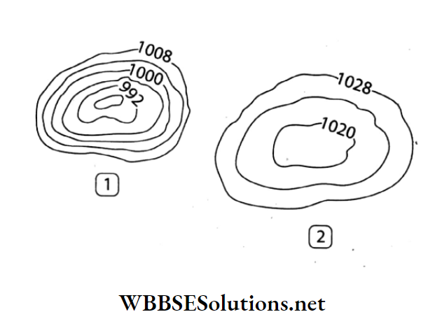
Answers:
1. Low-pressure diagram
2. High-pressure diagram
3. Wind flow from 2 to 1
Question 18. Do you have any idea what the winding black lines in the adjacent diagram are?
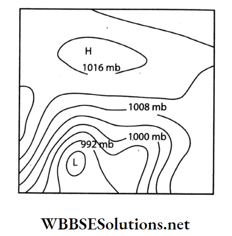
Answers:
The winding black lines in the adjacent diagram are called isobars. These imaginary lines join the places with equal air pressure at a particular time.
Question 19.
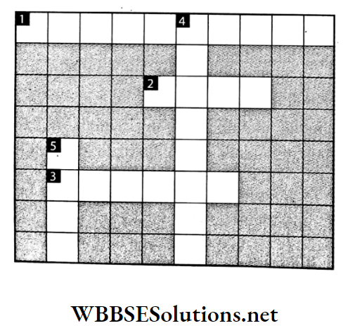
Down:
4. Instrument used to determine the direction of the wind.
5. Results from air pressure difference.
Across:
1. Tropical storm over Australia.
2. Unit of wind speed.
3. Line joining places having equal atmospheric pressure.
Answers:
Down: 4. WIND VANE 5. WIND
Across: 1. WILLY WILLY, 2. KNOT, 3. ISOBAR
Question 20.

Down:
4. Instrument used to measure atmospheric pressure.
5. Rate at which air moves from high pressure to low pressure.
Across:
1. Instrument used to measure wind speed.
2. Unit of atmospheric pressure.
3. Tropical storm originating over the Indian Ocean.
Answers:
Down: 4. BAROMETER, 5. WIND SPEED
Across: 1. ANEMOMETER, 2. MILLIBAR, 3. CYCLONE
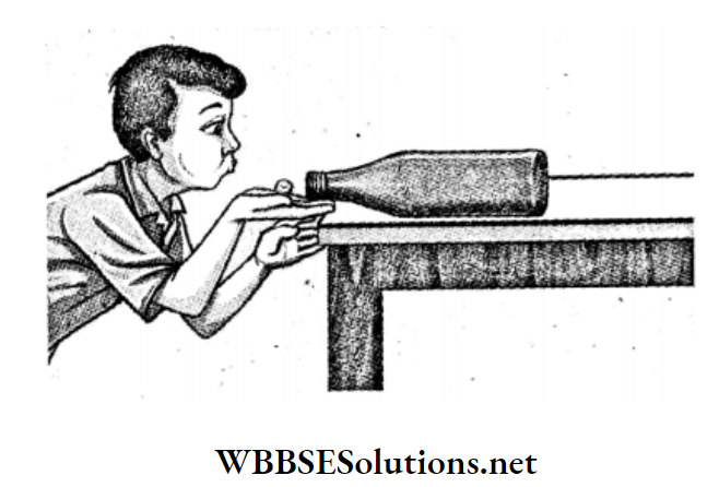
Question 21. Take a large, empty bottle with an open mouth. Crumple a paper to form a small ball so that the size of the ball is half the diameter of the mouth of the bottle. Now hold the bottle in a horizontal position and try to blow the ball into it. See what happens. Ask your friends to try the same. However strong you may be blowing, the ball does not enter the bottle. Why?
Answer:
A bottle is placed on the table. A paper is crumpled to make a small ball. If we try to blow in the paper ball through the mouth of the bottle then it is observed that the paper ball does not enter the bottle.
It will just move around the mouth of the bottle as if some force is not allowing it to go in. This happens because of the difference of pressure inside and outside the bottle.
It has been experimentally proved that the air pressure is always low where the wind speed is high. According to the diagram, the air pressure between the face and the paper ball is higher than the air pressure between the paper ball and the mouth of the bottle.
Thus the air pressure between the paper ball and the mouth of the person becomes lower than the air pressure between the bottle mouth and the paper ball. So for this reason, however strong we may be blowing, the ball does not enter the bottle.
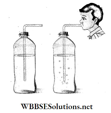
Question 22. Close a plastic bottle, partly filled with water, with a thin piece of polythene or a cork. Insert a narrow tube of pipe through the cap of the bottle and blow a few times, strongly, into the pipe. See what happens.
Answer:
If we put our mouths on the tube and blow a few times inside the bottle, we can see that some bubbles are formed in the water and these rise up to the top.
- This is because if we blow in a narrow tube, the air from the mouth enters through the tube and forms a bubble.
- These bubbles, made of air, being lighter than water come up on the water.
Question 23. It was a scorching hot day today. The sun was beating down hard all day. Srijan usually plays in the field after returning from school. But his mother didn’t let him go out today, because dark clouds were looming in the sky. Not a single leaf stirred. Suddenly a storm broke. The wind was lashing hard on the doors and the window panes. Soon after, it started to rain. Such a lull occurs before a storm. The wind hardly blows then. Why?
Answer:
During the daytime, the Earth’s surface is heated intensely by sun rays. Due to high temperature, the air of that place becomes warm, and light and rises up.
- In this way, the air adjacent to the Earth’s surface gradually gets heated up and rises.
- The place becomes airless to some extent. As a result, a deep low-pressure area is formed.
- Air does not flow horizontally until the heavy air of the surrounding areas rushes to the low-pressure area.
- That is why before the storm, the surrounding area is calm, and not a single leaf of a tree moves.
- When the relatively cold and heavy air gushes in to the low pressure area, the storm is created.
Question 24. Jhinuk went to Gomukh with her parents during the puja vacation. The ice cave of Gomukh is the source of the River Ganga, situated high in the Himalayas (almost 3900 m in height). The place was indeed beautiful but the food did not suit her. Rice and pulses could not be boiled well out here. Father said this was common in the high mountainous region. The air pressure being less in high mountainous regions, water starts to boil at low temperatures. Why does this happen?
Answer:
Generally air pressure decreases with increasing altitude. So the air pressure is quite low at Gomukh in the Himalayas at an altitude of 3900 metres.
- That is why the boiling point of water decreases in the highlands.
- When the pressure in the atmosphere is low, water boils at a temperature below 100°C. So food does not boil well.
- That is why it is difficult to cook rice and pulses in hilly areas.
Question 25.
WBBSE Chapter 3 Air Pressure Short Question And Answers
Question 1. Why don’t we feel the air pressure?
Answer:
We Dont feel the air pressure:
- Air exerts 1013.25 mb pressure on an adult human body.
- Human beings are used to this pressure because the air entering the human body through pores, mouth and windpipe exerts pressure outwards equalising it with the surrounding atmospheric pressure.
- So, we do not feel this huge amount of pressure exerted on our bodies.
Question 2. A vessel made of a thin sheet of tin with a small opening in It is partially filled with water and heated over a burner. While the water boils, the vapour goes out of the tin vessel. After some time, the opening of the tin vessel is closed with a cork and removed from the burner. What happens after the tin has cooled down?
Answer:
Initially the air pressure inside the tin vessel and the outside atmospheric pressure was equal, so the vessel remained in the normal state.
- When the water started boiling, the vapour coming out of the vessel removed the air inside along with it.
- Then, as the opening of the tin vessel was closed with a cork, air from outside could no longer flow inside.
- When the vessel cooled down, the atmospheric pressure inside the tin vessel became lower than the outside atmospheric pressure.
- As a result, the thin sheets of tin contracted inwards. This happens only due to the presence of atmospheric pressure.
Question 3. Can you boil water at room temperature without heating the vessel? If you can, how?
Answer:
Water is kept in a closed vessel at room temperature and an air-suction pump is attached to it. Now, the air from the vessel is sucked out gradually.
- We will see that the water starts boiling without being heated.
- With a decrease in pressure, the boiling point of any liquid also decreases.
- Now as the pressure exerted on water in this condition is very low, the boiling point of water becomes equal to the room temperature and the water starts boiling.
Question 4. How does atmospheric pressure vary?
Answer:
Air pressure is not equal everywhere.
- As gravitational force is highest at sea level, the distance between air molecules decreases and the density of air increases. So, atmospheric pressure is highest here.
- The gravitational force decreases with an increase in altitude.
- As a result, the distance between the air: molecules increases and the density of the air decreases, resulting in a decrease in the atmospheric pressure.
Question 5. Describe a barometer.
Answer:
Barometer:
Barometer was invented by a scientist named Torricelli in the year 1643. The variation of air pressure can be measured with it’s help.
- In this instrument, a cylindrical tube filled with mercury is kept upside down in a container filled with mercury. At normal atmospheric pressure, the height of the mercury column in the tube is 76 cm.
- With the decrease in atmospheric pressure, the height of the mercury column decreases and vice-versa. Thus, this instrument is used to predict weather conditions and measure altitude.
Question 6. How is the barometer used to predict the weather?
Answer:
Barometer readings help us to predict the weather condition of any place.
Question 7. Pressure is higher at the sea level and decreases with an increase in altitude. -Explain.
Answer:
Pressure is higher at the sea level and decreases with an increase in altitude:
The closer the molecules of air to one another, the denser is the air and the higher is its pressure.
- At sea level, the gravitational pull of the Earth is the highest.
- Moreover, the upper layers of the air exert pressure on the lower layer and so, the molecules become closely spaced and the density increases. Along with this, the pressure of the air also increases.
- However, the density of the upper layers is rarer as the molecules are sparsely placed. As a result, the pressure decreases with an increase in altitude.
Question 8. What is meant by the vertical distribution of atmospheric pressure?
Answer:
Vertical distribution of atmospheric pressure:
Average atmospheric pressure at sea level is 1 kg per sq cm or 1013.25 mb or 760 mm of mercury column or 76 cm of mercury column or 29.92 inches of mercury column.
- With the gradual increase in altitude from sea level, the volume and weight of air decrease.
- And thus atmospheric pressure decreases at a rate of 34 mb for every 300 metres of ascent.
Rate of variation of air pressure with altitude-
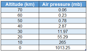
Source: MC Knight, Tom L (1990): Physical Geography, A Landscape, California (USA).
Question 9. What is the relation between atmospheric temperature and pressure?
Answer:
Relation between atmospheric temperature and pressure:
Atmospheric pressure is inversely dependent upon atmospheric temperature in the following ways-
- When a column of air gets heated up, its volume increases and expands. This expansion of air results in a decrease in pressure. So, when the temperature of air increases, pressure decreases.
- When the temperature of a column of air decreases, it contracts. With gradual contraction its density and pressure increase. So, pressure increases, with a decrease in temperature.
Real-life scenarios Involving Weather Changes Due to Air Pressure
Question 10. Why do mountaineers use oxygen
Answer:
Mountaineers use oxygen:
- The atmospheric pressure is very high near the Earth’s surface and gradually decreases upwards.
- With the decrease in atmospheric pressure i.e. as the air becomes thinner, the amount of oxygen in it decreases.
- It causes difficulties in breathing. As the air pressure at the top of high mountains is very less, mountaineers use oxygen cylinders to help them breathe properly.
Question 11. What is the effect of water vapour on atmospheric pressure?
Answer:
The effect of water vapour on atmospheric pressure:
Humid air (i.e. air with a high amount of water vapour) is comparatively lighter and its pressure is also less. So, regions with high water Descending- vapour content in the air experience low pressure.
- On the other hand, if the amount of water vapour present in the air is very less, it is called dry air and high pressure exists there.
- So, the atmospheric pressure is very low in the equatorial regions, while high pressure prevails in the polar regions due to a deficiency of water vapour.
Question 12. What is the equatorial low-pressure belt or doldrums?
Answer:
Atmospheric pressure cells:
- Due to the intense low pressure along the equatorial region, the winds are always warm and moist and move upwards.
- As there is no horizontal movement of wind in this region throughout the year, calm conditions prevail.
- So, this pressure belt is called the equatorial low-pressure belt or doldrums.
Question 13. What are the characteristics of isobars?
Answer:
The characteristics of isobars are as follows-
- Isobars are the black sinuous lines drawn on a weather map joining places of equal atmospheric pressure.
- Normal values of isobars over the Earth vary between 980 mb to 1050 MB. It is expressed in millibar.
- It is always shown according to the sea level pressure.
- They never intersect or touch one another.
- When the isobar lines are very close to one another, the pressure difference is high and the speed of the wind is also high.
Question 14. What are the characteristics of air pressure?
Answer:
The main characteristics of air pressure are as follows-
1. Relation with altitude: Air pressure decreases with an increase in altitude and increases with a decrease in altitude. Pressure decreases by about 34 mb for every 300 metres of ascent.
2. Relation with temperature: Air pressure decreases with an increase in temperature and vice-versa.
3. Relation with water vapour: The pressure of air saturated with water vapour is low. So, the atmospheric pressure is low during the monsoon season.
4. Occurrence of the storm: Sudden fall in air pressure may cause storms.
5. Standard atmospheric pressure: The mean atmospheric pressure is about 1013.25 mb at sea level.
6. High pressure and low pressure: Pressure that registers at more than 1013.25 mb is called high pressure and less than 986 mb is called low pressure.
7. Relation with isobar: If the isobars are closely spaced, it indicates a rapid change of air pressure.
Question 15. What are the importance of winds?
Answer:
The importance of winds are-
- They regulate the heat balance between different regions on the Earth.
- Many natural weather phenomena like clouds, rains, etc. occur due to winds.
- Winds regulate the balance between the high and low-pressure zones.
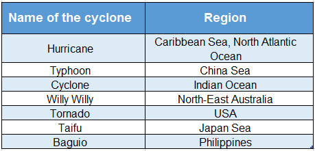
Question 16. Mention the different names of cyclones.
Answer:
Cyclones are known by different names in different parts of the world depending on which ocean it has formed over.
Question 17. What is Kalbaisakhi or Nor’westers?
Answer:
Kalbaisakhi or Nor’westers:
- East India, especially West Bengal and its surrounding regions experience torrential rains from thunderstorms and sometimes hailstorms in summer due to the cyclonic winds coming from the northwest direction.
- These thunderstorms are called Nor’westers or Kalbaisakhi, as they arrive mainly in the months of April and May. The latter name means “calamity of the month of Baisakh”.
Question 18. State the effect of atmospheric pressure on the day-to-day lives of the people living in Darjeeling.
Answer:
The effect of atmospheric pressure on the day-to-day lives of the people living in Darjeeling
- Darjeeling is located at an altitude of 2042 metres above sea level. At this altitude, the atmospheric pressure is lower than that of the plains i.e. approximately 795 MB.
- Due to low atmospheric pressure, water boils at a temperature of about 93.6°C which lengthens the time taken for food to be cooked. Thus, this creates problems in day-to-day activities.
Question 19. State the effect of atmospheric pressure on the day-to-day lives of the people living in the coastal areas of Puri.
Answer:
The effect of atmospheric pressure on the day-to-day lives of the people living in the coastal areas of Puri.
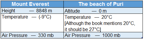
- The average temperature and atmospheric pressure in the coastal areas of Puri is around 20°C (although the book mentions 20°C, the temperature is 27° C) and 1000 MB respectively throughout the year.
- At this pressure level, food can be easily cooked and there is no difficulty.
- So, there is no problem in boiling food. This condition is favourable for carrying out normal day-to-day human activities.
Question 20. What are the applications of air pressure in our day-to-day life?
Answer:
The applications of air pressure that we observe in our daily life are-
- Water can be lifted with the help of a pump due to air pressure.
- We can drink any liquid with a straw due to air pressure.
- Liquids can be filled in syringes, sprayers can be filled with coloured water during Holi, and ink can be drawn into a dropper only due to air pressure.
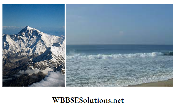
Question 21. How is the weather likely to be in these two places? If you travel from Puri beach to Mount Everest, what changes in your daily life are likely to happen?
Answer:
The weather of Puri Beach is comfortable or moderate i.e. neither too hot nor too cold. The weather of Mount Everest, on the other hand, is very cool.
The changes that come to everyday life when one goes to Mount Everest from the beach of Puri are-
- One has to take winter clothes to go to the place from 27° C to -9° C.
- Due to the height of Mount Everest, the air pressure will be low, so food will not get boiled well without a pressure cooker.
- For low air pressure bleeding from the nose and mouth, respiratory problems may occur. That is why the oxygen cylinder must be carried with.
Question 22. The people living on the plains get tired easily when they go to the hilly regions. Why?
Answer:
The people living on the plains get tired easily when they go to the hilly regions.
- As the density of air is less in the hilly regions, the amount of oxygen is also less.
- This low oxygen content in the atmosphere of hilly regions not only causes breathing problems but also makes people coming from plains feel tired easily.
Question 23. How can we use a barometer in the determination of altitude?
Answer:
We Can use a barometer in the determination of altitude
- Atmospheric pressure changes with altitude resulting in a difference in atmospheric pressure between two places lying at different altitudes.
- We can calculate this difference in altitude by measuring the difference in atmospheric pressure between two places with the help of a barometer.
Question 24. What are the characteristics of a cyclone?
Answer:
The characteristics of a cyclone are as follows-
- Low pressure exists in the centre, surrounded by high pressure.
- The cyclonic winds spiral in an anti-clockwise direction in the northern hemisphere and a clockwise direction in the southern hemisphere.
- In the centre of a cyclone, there are hot and upward-moving winds.
- In a cyclone, the speed of the wind is very high, often resulting in strong and destructive winds.
- This phenomenon, although powerful, is usually short-lived.
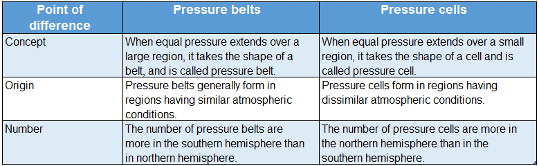
Question 25. State the difference between pressure belts and pressure cells.
Answer:
The differences between pressure belts and pressure cells are-
Question 26. What is the reason for the existence of atmospheric pressure on Earth?
Answer:
The reason for the existence of atmospheric pressure on Earth:
- As air itself has weight and exerts pressure on the Earth’s surface, there is the existence of atmospheric pressure.
- The Earth has a huge mass and hence exerts a strong gravitational force.
- Due to this strong gravity, it can hold onto this large atmosphere.
Question 27. We use straws for drinking cold drinks. How does the liquid come up through the oes the straw?
Answer:
- While drinking cold drinks, one end of the straw is in our mouth while the other is dipped into the liquid. When we suck the air out of the straw, low pressure is created inside it.
- The atmospheric pressure acting on the liquid surface pushes the liquid up through the straw.
Question 28. When a syringe is dipped into water and the piston is pulled up, why does water come up through the mouth of the syringe? Or, How does water come up into a syringe?
Answer:
- A low pressure is created inside the syringe when we pull the piston of a syringe while dipping its mouth into the water.
- The atmospheric pressure acting on the water surface pushes the water up into the syringe.
Question 29. One of your neighbours is going to climb Mount Everest. How can you make him aware of the dangers he might face?
Answer:
- Mount Everest is the highest mountain in the world (8848 metres). At this height, the atmospheric pressure is rd of the pressure at sea level, i.e. 330 millibars.
- As the air pressure is very low there, it becomes difficult to breathe. So, I will advise him to carry an oxygen cylinder while climbing.
- Also, as the air pressure is very low at such a high altitude, our blood pressure rises. So often, mountaineers experience bleeding from the nose, eyes, ears, etc. I will also warn him about this.
Question 30. If you visit Gomukh Ice Cave and put your hand in the boiling water, your hand does not burn.-Why?
Answer:
Gomukh is located at a very high altitude above sea level (about 3900 metres).
- At this height, the pressure of air is very low and thus, water boils at a temperature much lower than 100° C.
- So, when you touch that boiling water, your hand does not burn.
Question 31. Why is it difficult to cook food in hilly regions?
Answer:
- The atmospheric pressure decreases with an increase in altitude. We know that, boiling point increases with an increase in the air pressure.
- But, as air pressure is less in hilly regions, the food materials start to boil at a temperature less than 100°C, taking more time for the food to get cooked.
Question 32. It is always advised to cook rice in a covered vessel.-Why?
Answer:
- If rice is cooked in a covered vessel, the water vapour cannot leak out of the vessel. This vapour pressure inside the vessel becomes more than the atmospheric pressure.
- Due to this excess vapour pressure, the rice inside starts to boil at a temperature more than 100°C and gets cooked quickly.
Question 33. Why is atmospheric pressure low during the monsoon season?
Answer:
- Saturated air (i.e. air with a maximum limit of water vapour) is lighter than dry air. Thus the atmospheric pressure decreases with an increase in the amount of water vapour in the air.
- In the monsoon season, the amount of water vapour in the air is very high. So, the atmospheric pressure is very low.
Question 34. Why is the atmospheric pressure high in the polar regions?
Answer:
- In both polar regions, the sunrays fall obliquely and so, do not adequately heat up the surface and the air above it. So, the polar air remains cold and keeps on contracting.
- With the gradual contraction of air, the air density increases along with its pressure. Thus, atmospheric pressure is high in the polar regions.
Question 35. What do you mean by air current?
Answer:
Air Current:
- The vertical movement of air from a region of high pressure to a region of low pressure is called air current. When the air at any place gets heated up, it expands, gets lighter and moves upwards vertically.
- Cold air from the surrounding regions rushes in to take its place. This vertical or nearly vertical movement of air causes air current.
Question 36. Why does the weather become calm before the storm?
Answer:
Storms are usually formed due to high temperatures. In some regions, the air gets hotter and lighter and moves upwards.
- An intense low-pressure zone forms over the region. At this time, there is no horizontal flow of air.
- So, the weather becomes calm before the storm.
- Cold air from the surrounding region rushes in the form of storms to fill in the region of low pressure.
Question 37. Why do astronauts wear special spacesuits that are filled with air?
Answer:
- As there is no air in space, the nerves and blood vessels can explode due to the pressure exerted by air from inside the body of the astronauts.
- So, they wear special spacesuits which are filled with air before going to space. So that there is a balance of air pressure.
WBBSE Chapter 3 Air Pressure Very Short Question And Answers
Question 1. I flow from the high-pressure zone to the low-pressure zone. Who am I?
Answer: Air
Question 2. I move with tremendous velocity from centres of high pressure to centres of low pressure with a circular motion. Who am I?
Answer: Cyclone
Question 3. Atmospheric pressure is measured with my help. Who am I?
Answer: Barometer
Question 4. I invented the barometer. Who am I?
Answer: Torricelli
Question 5. I am the unit of measurement of air pressure. Who am I?
Answer: Millibar
Question 6. The air becomes lighter when I mix with it. Who am I?
Answer: Water vapour
Question 7. I am an imaginary line joining all the places on the Earth’s surface with equal atmospheric pressure. Who am I?
Answer: Isobar
Question 8. I am used to determining the air pressure in a barometer. Who am I?
Answer: Mercury
Question 9. I exert a pressure of 1013.25 mb at sea level. Who am I?
Answer: Air
Question 10. In hilly regions, it is difficult to cook rice and pulses due to my deficiency. Who am I?
Answer: Air pressure
Question 11. It is difficult to breathe in the hilly regions of high altitude due to my deficiency. Mountaineers carry me with themselves. Who am I?
Answer: Oxygen
Question 12. What are isobars?
Answer:
Isobars:
The imaginary lines drawn on a map joining places with equal atmospheric pressure at a particular time are known as isobars. In a weather map, the isobars are expressed in millibars with the help of black, sinuous lines.
Question 13 While filling up air in a balloon or a cycle tyre, if more air is filled by chance, it bursts.-Explain why?
Answer:
The elastic nature of the balloon or a cycle tyre, allows a little more air to be filled. But if excessive air is filled by chance, the surplus pressure cannot be withstood by the walls of the balloon or the cycle tyre and so, it bursts.
Question 14. Why does food get cooked faster in a pressure cooker?
Answer:
While cooking in a pressure cooker, the pressure of the water vapour is increased to boil water at a temperature higher than 100°C. As the temperature rises, the food gets boiled faster and, so gets cooked quickly.
Question 15. What is meant by normal or standard atmospheric pressure?
Answer:
The pressure exerted at sea level by 76 cm of mercury column at 0°C temperature, at 45° North latitudes, is called the standard atmospheric pressure. It is equal to 1 kg per sq cm or 1013.25 mb.
Question 16. What is the name of the force exerted by any air mass on the Earth’s surface?
Answer: Air pressure.
Question 17. What is the average pressure of air at sea level?
Answer: 1013.25 MB.
Question 18. Name the instrument used to measure atmospheric pressure.
Answer: Barometer.
Question 19. Who invented the barometer in the year 1643?
Answer: Evangelista Torricelli.
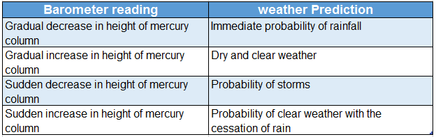
Question 20. What type of weather is indicated by the sudden fall of mercury in a barometer?
Answer: Stormy weather.
Question 21. How much does air pressure decrease for every 110-metre rise in altitude?
Answer: 1 cm of mercury column.
Question 22. What type of relationship exists between temperature and air pressure?
Answer: Inversely proportional.
Question 23. What is the relation between altitude and atmospheric pressure?
Answer: Inversely proportional.
Question 24. What type of pressure is created as water vapour mixes with the air?
Answer: Low pressure.
Question 25. Name the high-pressure and low-pressure centres surrounding the Earth.
Answer: Pressure belts.
Question 26. How many permanent high-pressure belts exist on Earth?
Answer: 4 (Four).
Question 27. Which pressure belt is formed surrounding the Equator?
Answer: Equatorial low-pressure belt.
Question 28. Which pressure belt is formed surrounding the Tropic of Cancer and the Tropic of Capricorn?
Answer: Sub-tropical high-pressure belt.
Question 29. Name the pressure zone that is formed between 70°-90° parallels of latitudes.
Answer: Polar high-pressure belt.
Question 30. Name the imaginary line that connects all places with equal atmospheric pressure.
Answer: Isobar.
Question 31. What are the areas with lesser atmospheric pressure than the standard atmospheric pressure known as?
Answer: Low-pressure area.
Question 32. What are the areas with higher atmospheric pressure than the standard atmospheric pressure known as?
Answer: High-pressure area.
Question 33. Name the horizontal movement of air from the high-pressure to the low-pressure zone.
Answer: Wind.
Question 34. Name the spiralling winds that move at high velocity from high-pressure regions to low-pressure regions.
Answer: Cyclonic winds.
Question 35. Name the type of whirlwind that originates over the China Sea.
Answer: Typhoon.
Question 36. Name the type of whirlwind that is found in the United States of America.
Answer: Tornado.
Question 37. Name the type of whirlwind originating over the Indian Ocean.
Answer: Cyclone.
Question 38. Name the whirlwind originating over the Caribbean Sea.
Answer: Hurricane.
WBBSE Chapter 3 Air Pressure Fill In The Blanks
Question 1. The unit for measuring air pressure is _______.
Answer: Millibar
Question 2. The instrument used for measuring atmospheric pressure is known as _______.
Answer: Barometer
Question 3. For measuring the temperature, a _______ is used with the barometer.
Answer: Thermometer
Question 4. The average atmospheric pressure at sea level is _______ mb.
Answer: 1013.25
Question 5. The average air pressure at sea level is _______ inches of mercury.
Answer: 29.92
Question 6. Air pressure is _______ in the mines than at sea level.
Answer: Higher
Question 7. In nature, pressure _______ with an increase in air temperature and pressure with a decrease in air temperature.
Answer: Decreases, increases
Question 8. _______ winds are heavy so, their pressure is high.
Answer: Cold
Question 9. Air pressure _______ with an increase in altitude from sea level.
Answer: Decreases
Question 10. With the increase in density of air, pressure _______.
Answer: Increases
Question 11. Mountaineers use _______ cylinders at high altitudes.
Answer: Oxygen
Question 12. With the increase in temperature, the pressure of air _______.
Answer: Decreases
Question 13. The total number of pressure belts observed over the Earth’s surface are _______.
Answer: 7
Question 14. Equatorial low-pressure belts exist between _______ to _______ parallels of latitudes.
Answer: 5° N, 5°S
Question 15. In the equatorial region, _______ pressure belts are formed.
Answer: Low
Question 16. Sub-polar low-pressure belts are observed approximately over _______ latitudes.
Answer: 66½°N and S
Question 17. Sub-tropical high-pressure belt near the Tropic of Cancer is located between _______ latitudes.
Answer: 25° N-35° N
Question 18. The number of pressure cells are more in the _______ hemisphere.
Answer: Northern
Question 19. Air pressure decreases in the _______ season.
Answer: Summer
Question 20. In the month of July, _______ belt is formed in the interior parts of the continent of Asia.
Answer: Low pressure
Question 21. The principal cause of airflow is the difference in _______ between two places.
Answer: Pressure
Question 22. Air flows from _______ pressure zones to pressure zones.
Answer: High, low
Question 23. Air pressure less than 986 mb is called _______.
Answer: Low pressure
Question 24. The difference in air pressure between any two places determines the _______ between those two places.
Answer: Pressure gradient
Question 25. Higher air pressure: Sea level:: Lesser air pressure: ___________.
Answer: Mountainous region
Question 26. Air temperature: Isotherm:: Air pressure: ___________.
Answer: Isobar
Question 27. High pressure: Clear and calm weather:: Low pressure: ___________.
Answer: Stormy and turbulent weather
WBBSE Chapter 3 Air Pressure True Or False
Question 1. Atmospheric pressure is 1.5 kg per sq. cm.
Answer: False
Question 2. Sub-tropical high-pressure belts lie between 30°-40° N and S parallel of latitudes.
Answer: True
Question 3. The atmosphere exerts a pressure of 5500 millibars on an adult human body.
Answer: False
Question 4. The atmospheric pressure increases with the increase in the amount of water vapour in the air.
Answer: False
Question 5 Air pressure increases by 34 millibars approximately for every 300 metres of ascent.
Answer: False
Question 6. Air pressure is measured by a wind vane.
Answer: False
Question 7. The weight of air per unit area is called air pressure.
Answer: True
Question 8. Air pressure increases with the rise in air temperature.
Answer: False
Question 9. The pressure of wet air is less than dry air.
Answer: True
Question 10. The polar high-pressure belts lie at the North and South Poles.
Answer: True
Question 11. The unit of measuring air pressure is millibar.
Answer: True
Question 12. As the air near the Earth’s surface is dense, the pressure is lowest in this zone.
Answer: False
Question 13. Air pressure at sea level is approximately 1003.25 mb.
Answer: False
Question 14. There are 3 low-pressure belts and 4 high-pressure belts on the Earth’s surface.
Answer: True
Question 15. A sudden fall on the mercury column of a barometer indicates the probable occurrence of storm.
Answer: True
Question 16. The cyclones formed in the USA are called Hurricanes.
Answer: False
Question 17. A barometer can also be used to measure altitude.
Answer: True
Question 18. The latitudinal extension of air pressure cells is less in the northern hemisphere.
Answer: False
Question 19. Intense low pressure exists at the centre of a cyclone.
Answer: True
Question 20. The speed of air is measured with the help of a barometer.
Answer: False
WBBSE Chapter 3 Air Pressure Find The Odd One Out
Question 1. Typhoon: Southerly winds: Tornado: Cyclone
Answer: Southerly winds (not a type of cyclone)
Question 2. High pressure: Air current: Low pressure: Temperature
Answer: Air current (not related to air pressure)
Question 3. Water vapour: Loo: Low pressure: Whirlwind
Answer: Loo (not directly related to air pressure)
Question 4. Trade wind: Westerlies Polar wind: Sea breeze
Answer: Sea breeze (not a planetary wind)
WBBSE Chapter 3 Air Pressure Correct The Following
Question 1. Air pressure is 1 kilogram for every square foot.
Answer: Ton
Question 2. Air pressure increases with an increase in altitude.
Answer: Decreases
Question 3. Air exerts pressure downwards.
Answer: In all directions
Question 4. Torricelli invented the thermometer.
Answer: Barometer
Question 5. The instrument used to measure air pressure is a hygrometer.
Answer: Barometer
Question 6. Moist air is more than dry air at the same temperature.
Answer: Less
WBBSE Chapter 3 Air Pressure Scrambled words
1. ESPRRESU
2. MEROTERBA
3. LLIRBAMI
4. AROBIS
5. CARIHURNE
6. ONTYPHO
Answers:
1. PRESSURE
2. BAROMETER
3. MILLIBAR
4. ISOBAR
5. HURRICANE
6. TYPHOON
WBBSE Chapter 3 Air Pressure Match The Columns
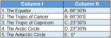
Question 1. 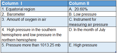
Answer: 1. B, 2. C, 3. A, 4. D, 5. E
Question 2.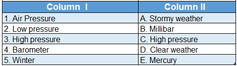
Answer: 1. B, 2. A, 3. D, 4. E, 5. C