WBBSE Class 8 Geography Chapter 4 Topic B Planetary Winds Shifting Of Pressure Belts And Other Winds

Chapter 4 Topic B Planetary Winds Shifting Of Pressure Belts And Other Winds Analytical Type Questions

Question 1. Explain briefly the relation between the pressure belts and the planetary winds.
Answer:

Relation Between The Pressure Belts And The Planetary Winds:-

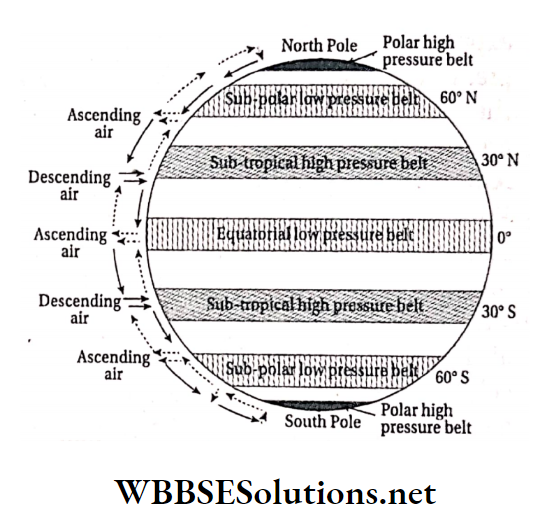
There are seven pressure belts around the world which are very closely related to the planetary winds. As the earth rotates from west to east, the winds get deflected to the right in the northern hemisphere and to the left in the southern hemisphere.

Winds blow from high-pressure zones to low-pressure zones to maintain a balance between the air pressure of different regions. There are four high-pressure and three low-pressure belts on the earth.

Permanent or planetary winds arise from sub-tropical and polar high-pressure belts and move towards equatorial and sub-polar low-pressure belts. There are three planetary winds, namely trade winds, westerlies and polar winds.

Trade winds:

The permanent low-pressure belt of the equatorial region attracts winds from the sub-tropical high-pressure belts. This wind blows from the northeast in the northern hemisphere and south east in the southern hemisphere (by Ferrel’s law) and are called northeast trade winds and southeast trade winds respectively.

Read and Learn More WBBSE Solutions For Class 8 Geography

As per nautical expression the term ‘trade’ suggests blowing along a regular path. Trade winds shift more to the north and south of their normal paths following the annual migration of the sun.

WBBSE Solutions For Class 8 Geography Chapter 4 Topic B Planetary Winds Shifting Of Pressure Belts And Other Winds Wind Movement on the earth

WBBSE Class 8 Planetary Winds Overview

Westerlies:

These blow outside the tropics, in the temperate zone, mainly in the opposite direction of the trade winds between 35° and 60° north and south latitudes.

These also get deflected due to the rotational force of the earth and blow from the southwest in the northern hemisphere and the northwest in the southern hemisphere.

As these are western winds, they cause rainfall chiefly in the western parts of the continents, keeping the eastern sides dry. These winds do not follow a fixed direction or path either.

However, in the southern hemisphere, the westerlies are much stronger due to the absence of larger landmasses which obstruct their path and reduce the wind speed in the northern hemisphere.

Class 8 Geography Chapter 4 Planetary Winds Notes

Polar winds:

Scientists have established that there exist two permanent high-pressure belts in the south and north poles and two comparatively low-pressure belts along the sub-polar regions.

Due to this, icy polar winds blow from high-pressure zones of the poles to the sub-polar low-pressure zones regularly. These winds deflect towards the west in both hemispheres. These are called the polar easterlies.

WBBSE Class 8 Geography Chapter 4 Topic B Planetary Winds Shifting Of Pressure Belts And Other Winds

Question 2. Classify the trade winds and discuss their characteristics and influence.
Answer:

Classification Of Trade Winds:-

The winds that blow from sub-tropical high-pressure belts of both the hemispheres to the equatorial low-pressure belt are called the trade winds. This is a permanent wind blowing regularly throughout the year in the same direction at a uniform speed.

There are two types of trade winds

North-east trade winds:

These winds blow from the sub-tropical high-pressure belt of the northern hemisphere towards the equatorial low-pressure belt. They deviate to the right and blow from the north-east direction according to Ferrel’s law. so these winds are known as the northeast trade winds.

South-east trade winds:

These winds blow from the sub-tropical high-pressure belt of the southern hemisphere to the equatorial low-pressure belt and deviate to the left as per Ferrel’s law. They blow from the southeast so these winds are known as the southeast trade winds.

Characteristics:

The characteristics of trade winds are

1. Velocity:

Having vast stretches of landmass in their path in the northern hemisphere, here the trade winds blow at a slower speed of nearly 16km/h. On the other hand, the southern hemisphere has less landmass compared to waterbodies.

So the winds travel here at a high velocity of 22-30km/h.

2. Extent:

The trade winds normally blow within 5°-25° north and south latitudes on either side of the equator.

Understanding Shifting Pressure Belts for Class 8

Influence:

The trade winds have contributed to the development of the hot deserts in the world. The deserts are situated on the western margins of the continents that are not benefited by the moisture brought in by easterly trade winds.

As a result, deserts such as the Kalahari, the Sahara and the Atacama have developed. On the other hand, the trade winds are blessings to the farmers in the eastern parts of the continents, where these winds cause sufficient precipitation for the cultivation of crops.


WBBSE Solutions For Class 8 Geography Chapter 4 Topic B Planetary Winds Shifting Of Pressure Belts And Other Winds Wind Movement on the earth


Question 3. Classify and mention, the features of Westerlies.
Answer:

Classification Of Westerlies:-

The westerlies are of two types

  1. In the northern hemisphere, as per Ferrel’s law, the winds get deflected to the right while moving along their path towards the sub-polar low-pressure belt. So, they are known as the southwest westerlies in the northern hemisphere.
  2. Similarly, they become the north-west westerlies in the southern hemisphere due to the rotation of the earth.

WBBSE Class 8 Geography Chapter 8 Question Answer

Features Of Westerlies:-

Some of the important features of the westerlies include

  1. The speed and direction of these winds are not as constant and steady as the trade winds.
  2. Having larger water- bodies along their way, the westerly winds collect sufficient water vapour to cause rainfall on the western margins of the continents.
  3. Apparent migration of the sun also shifts the area that comes under the influence of the westerlies slightly to the north or south of the equator.
  4. The southern hemisphere, having a larger percentage of water surface than landmass, records stronger and more constant westerly winds.
  5. The westerlies around 40°, 50° and 60° south latitudes, are called the ‘roaring forties’, ‘furious fifties’ and ‘screaming
    sixties’ respectively.
  6. In the regions over which the westerlies blow, cyclones and anti-cyclones often originate.
  7. Westerlies are stronger in winter and weaker in summer.


WBBSE Solutions For Class 8 School Science Long Answer Type Questions WBBSE Solutions For Class 8 School Science Short Answer Type Questions
WBBSE Solutions For Class 8 School Science Very Short Answer Type Questions WBBSE Solutions For Class 8 School Science Review Questions
WBBSE Solutions For Class 8 School Science Solved Numerical Problems WBBSE Solutions For Class 8 School Science Experiments Questions
WBBSE Solutions For Class 8 Maths WBBSE Class 8 History Notes
WBBSE Class 8 History Multiple Choice Questions WBBSE Solutions For Class 8 History
WBBSE Solutions For Class 8 Geography


Question 4. What do you know about the polar winds? Classify and explain their features.
Answer: The winds that blow from the high-pressure belts of the polar region to the sub-polar low-pressure belts of both hemispheres, are called polar winds.

Classification Of Polar Winds:-

According to their path of flow, polar winds can be of two types

  1. Polarwinds that blow from the North Pole towards the sub-polar belt in the northern hemisphere, get deflected to the right (as per Ferrel’s law) and are called north-east polar winds.
  2. Similarly, winds blowing from the South pole towards the sub-polar belt in the southern hemisphere also get deflected to the left (as per Ferrel’s law) and are called south-east polar winds.


WBBSE Solutions For Class 8 Geography Chapter 4 Topic B Planetary Winds Shifting Of Pressure Belts And Other Winds Polar winds


Features Of Polar Winds:-

Some important features of polar winds are

  1. The Polar winds are very cold and heavy.
  2. These are very dry and almost devoid of water vapour.
  3. These are more active in the southern hemisphere than in the northern hemisphere.
  4. Polar winds cause snowfall and blizzards at the poles.

Question 5. What are the effects of the planetary winds on Earth?
Answer:

Effects Of The Planetary Winds On Earth:-

Planetary winds blow in a regular pattern throughout the year in fixed directions from regions of high pressure to regions of low pressure on the Earth. There are three types of planetary trade winds, westerlies and Polar winds.

WBBSE Class 8 Geography Types of Winds

Effects of the trade winds:

After collecting a sufficient amount of water vapour while blowing over the seas, the trade winds cause rainfall on the eastern margins of the continents. This favours agricultural activities there. For example, northeast Brazil, northeast Australia, and the Islands of Hawaii have favourable climatic conditions and agriculture has flourished there.

The trade winds blow from northeast in the northern hemisphere and southeast in the southern hemisphere.

After causing rainfall in the eastern parts, when these winds reach the western part of the continents, they lose most of their moisture content. So, these regions get very little rainfall and major deserts have developed here, such as the Sahara, the Kalahari, the Atacama, etc.

With their constant and defined path and speed, in the earlier times, these winds used to help in the navigation of ships and trade, thus earning the name trade wind.

Effects of the westerlies:

  1. The westerlies also collect sufficient moisture while blowing over the seas and cause precipitation on the western margins of the continents due to their direction of flow. These conditions also favour agricultural practices in those regions. For example, the land around the Mediterranean Sea.
  2. The westerly winds blow from south-west in the northern hemisphere and from north-west in the southern hemisphere. These winds cause less rainfall on the eastern parts of the continents situated along their way; but the middle parts receive moderate rainfall and thus, temperate grasslands have developed in such regions of the world. For example, the Prairies in North America, Pampas in South America, Steppe in Central Asia, Veld in South Africa and Downs in Australia are such temperate grasslands.

Effects of the polar winds:

Polar winds blow over the eastern part of the continents. Thus, the climate of the eastern margins of these continents become extremely cold and they experience regular snowfall.

The cold polar winds also cause snowstorms in the polar regions, for example blizzards in Antarctica.

Question 6. Explain the shifting of pressure belts.
Answer:

Shifting Of Pressure Belts:-

The pressure belts follow the apparent annual migration of the sun to the north on the Tropic of Cancer (on June 21) to the south on the Tropic of Capricorn (on December 22), reaching its points of zenith twice on the Equator (on March 21 and September 23).

On June 21, the sun is directly overhead on the Tropic of Cancer and all the pressure belts shift towards the north by 5°-10°. On December 22, the sun shines vertically over the Tropic of Capricorn and similarly, all the pressure belts move southward.


WBBSE Solutions For Class 8 Geography Chapter 4 Topic B Planetary Winds Shifting Of Pressure Belts And Other Winds Shifiting of pressure belts


Winds are largely influenced by this shifting of the pressure belts during the annual migration of the sun. The changes that occur are more prominent in the lower latitudes than in the higher latitudes.

Effect:

Maximum effect of this shifting of the pressure belts is observed between 30° and 40° north and south latitudes, where the regions remain under the influence of trade winds in summer and westerlies in winter.

The eastern margins of the continents receive precipitation due to easterly trade winds while the western parts of those regions remain dry.

Planetary Winds and Their Importance for Class 8

For example, the southern part of Argentina and Sudan get rain while the western parts of the Mediterranean regions (such as south Chile) remain dry.

On the other hand, the same western areas get heavy rainfall under the influence of the westerlies in winter, while the eastern margins remain dry. As the pressure belts shift with changing of seasons, the belts of precipitation also change their positions.

Question 7. Discuss the different types of periodic winds.
Answer:

Different Types Of Periodic Winds:-

Unequal air pressure between land and water surfaces at a particular place, at a particular time or period, gives rise to periodic winds.

There are three types of periodic winds

  1. Sea breeze
  2. Land breeze and
  3. Seasonal winds.

1. Sea breeze:

The landmass, being warmer than the adjacent sea during the day, forms a low pressure area (almost a vacuum) above it. As a result, a comparatively cooler airblows over the sea.

This is called the sea breeze. The sea breeze often brings showers in the coastal regions.

2. Land breeze:

At night, the sea remains warmer than the adjacent land portion, which has already discharged its heat. The cool air over the land thus moves towards the warm sea.

This cool wind usually starts blowing at midnight or in the later part of the night and is called the land breeze.

3. Seasonal winds:

The difference temperature and air pressure on land and its adjacent water body causes winds to move towards land from the waterbodies or vice- versa. These winds change their direction season-wise, according to the prevailing conditions.

Hence, these are known as seasonal winds. They are also known as monsoon winds in India. The monsoon wind blows from south-west in summer and from north-east in winter.

In summer, the monsoon winds bring rain in India, while in winter, the monsoon winds are usually dry.

Question 8. What are local winds? Discuss some of the local winds.
Answer:

Local winds:

A difference in temperature and air pressure gives rise to certain winds that are influenced by the local topography and atmosphere of a particular place. These are called local winds. Example-Loo, Foehn, Chinook, Pampero, Sirocco, Khamsin, Andhi.

Some local winds:

Three local winds are discussed below

1. Loo:

It originates from the north-western landmass of India during the day. It is a very hot and dry wind that blows strongly over the land in a horizontal manner. Loo blows mainly over Delhi and parts of Rajasthan.

2. Foehn:

It is a dry and hot wind that blows down the leeward slope of the Alps in Europe. Foehn blows with great force. During spring, it melts the snow very quickly and thus helps in the luscious growth of pasture lands.

3. Chinook:

It is similar to Foehn, blowing eastward across the Prairies of North America from the eastern slope of the Rocky Mountains in the west. ‘Chinook’ in English means ‘snow eater’, as it increases temperature and melts the snow of the extended Prairie region. This wind strictly blows in winter.

WBBSE Class 8 Geography Wind Movement Explanation

Question 9. How have the names like Aila, Thane, Phailin, Helen, Lehar, Haiyan, etc., come to mean various cyclonic storms?
Answer: Meteorologists name the cyclonic storms that occur in various places around the world.

For example, cyclones are known as

  1. Hurricane over the caribbean sea
  2. Typhoon in japan and south china sea
  3. Baguio in the philippines island, etc.

Similarly, the tropical cyclones in the Indian subcontinent are assigned different local names. These are Aila, Thane, Phailin, Helen, Lehar, etc. In the year 2000, the WMO (World Meteorological Organisation) decided to officially accept these local names.

It was decided that the cyclones originating in the Indian Ocean would be named by the countries around the ocean, including Bangladesh, India, Maldives, Myanmar, Oman, Pakistan, Sri Lanka, and Thailand.

Each country will submit a list of probable names for the storms which will be arranged alphabetically according to the first letter of the country’s name and the names of the cyclones in this region will be chosen from the respective lists.

Example ‘Aila’ came from Maldives, Phailin or Pilin’ came from Thailand, ‘Lehar’ from India, ‘Hudhud’ from Oman, ‘Fani’ from Bangladesh, etc.

Question 10. Explain briefly the variable winds. Or, What are cyclones and anti- cyclones? Explain in brief.
Answer:

Variable Winds:-

The winds that suddenly cease after blowing for a short span of time, depending on the local air pressure, are called variable or irregular winds.

A drastic, unpredictable rise or fall of air pressure in highly localised area gives rise to sudden or irregular winds. These winds are mainly of two types

  1. Cyclones and
  2. Anti-cyclones.

1. Cyclones:

A cyclone is a low pressure system with winds blowing anti-clockwise in the northern hemisphere and clockwise in the southern hemisphere. The pressure falls rapidly at the centre, with strong winds spiralling around it.

The isobars in this region are either circular or oval in shape. Cyclones can be of two types according to their origin and structure

  1. Tropical cyclones and
  2. Temperate cyclones.

Tropical cyclones:

Class 8 Geography WBBSE

Upward moving air that moves towards the centre of a low pressure area at a high velocity and in a spiral manner is called Tropical cyclone.

These cyclones originate over seas and oceans in the tropical regions, between 16° and 24° latitudes in either hemispheres. It is known by different names in different regions.


WBBSE Solutions For Class 8 Geography Chapter 4 Topic B Planetary Winds Shifting Of Pressure Belts And Other Winds Direction of wind Movement in a cyclone


It is called ‘Cyclone’ in the Arabian Sea and Bay of Bengal, “Typhoon’ in South and East China Sea, ‘Hurricane’ in the Caribbean Sea.

Temperate cyclones:

The hot and cold winds blowing between 35° and 65° latitudes on both sides of the equator meet and gives rise to a ‘front. Cold winds being heavy, descend downwards and fill up the place of the hot wind.

The warm air mass overrides the cold air as the former is lighter. It rises up in a spiral manner and this is known as temperate cyclone.

2. Anti-cyclones:

An anti-cyclone is a weather condition having high pressure at its centre, associated with calm and fine weather. The winds blow clockwise in the northern hemisphere and anti-clockwise in the southern hemisphere.

Circular isobars prevail in these regions. They move very slowly, drifting or remaining stationary at times.

Class 8 Geography WBBSE


WBBSE Solutions For Class 8 Geography Chapter 4 Topic B Planetary Winds Shifting Of Pressure Belts And Other Winds Direction of wind Movement in a Anti-cyclone


Question 11. Compare among trade winds, westerlies and polar winds.
Answer:

Comparison among trade winds, westerlies and polar winds are

WBBSE Solutions for Class 8 Geography Chapter 4 Topic B Compare among trade winds, westerlies and polar winds.


Chapter 4 Topic B Planetary Winds Shifting Of Pressure Belts And Other Winds  Short Analytical Type Questions

Question 1. What makes wind blow?
Answer:

Wind Blow:-

Difference in air pressure causes movement of wind. As per the natural tendency, winds always blow from high-pressure zones to low-pressure zones to maintain the pressure balance in the atmosphere.

The difference in pressure between two areas is the main factor what makes wind blow. Solar energy has great impact on the wind movement too. The sun’s heat increases the temperature of the air mass, making it expand, rise and form low-pressure regions.


WBBSE Solutions For Class 8 Geography Chapter 4 Topic B Planetary Winds Shifting Of Pressure Belts And Other Winds Wind Movement due to difference in air pressure


For example, the equatorial low-pressure belt attracts cold and heavy winds from the sub-tropical high-pressure belts. On the other hand if the difference in pressure is negligible, calm weather conditions prevail.

Question 2. What is centrifugal force?
Answer:

Centrifugal Force:-

The rotational force of earth is felt maximum at the equatorial region and is almost nil at the poles.

This rotation tends to deflect all free flowing objects outward while the gravitational pull attracts everything towards the centre of the earth. The force the centrifugal force.

Characteristics of Planetary Winds for Class 8

WBBSE Solutions For Class 8 Geography Chapter 4 Topic B Planetary Winds Shifting Of Pressure Belts And Other Winds Centrifugal force

Question 3. What is Coriolis force?
Answer:

Coriolis Force:-

G.D. Coriolis, a renowned scientist, first observed a kind of a deflecting or distracting force that originates due to the rotation of the earth.

Winds and ocean currents are mainly influenced by this force and get deflected to the right in the northern hemisphere and to the left in the southern hemisphere.

This force was named Coriolis force. Coriolis force has the maximum effect at the poles and the minimum at the equator.

Question 4. Define Ferrel’s law.
Answer:

Ferrel’s Law:-

As the earth is a sphere, its rotational force is not uniform everywhere. It tends to decrease gradually towards the poles from the equator. Thus, winds cannot blow straight on the surface of the earth and have to move in a curved manner.

This deflection occurs in a definite way. As a result, winds deviate to the right in the northern hemisphere and to the left in the southern hemisphere.

This was established by the famous American meteorologist William Ferrel in 1856 and is which deflects everything outwards is called known as the Ferrel’s law.


WBBSE Solutions For Class 8 Geography Chapter 4 Topic B Planetary Winds Shifting Of Pressure Belts And Other Winds Deflection of path of wind


Question 5. Explain Buys Ballot’s law.
Answer:

Buys Ballot’s Law:-

In 1857, a Dutch meteorologist Buys Ballot found that in the northern hemisphere if you stand facing the wind, there will be low pressure to your left and high pressure to your right.

Class 8 Geography WBBSE

In the southern hemisphere, the situation is reversed. This relationship between wind movement and air pressure was first explained by him. Hence, it is known as Buys Ballot’s law.

WBBSE Solutions For Class 8 Geography Chapter 4 Topic B Planetary Winds Shifting Of Pressure Belts And Other Winds Direction of wind Wind movement and air pressure


Question 6. Classify the wind system.
Answer:

Classification Of Wind System:-

Wind system of the earth can be classified mainly into four broad categories, which are further of many types. This has been represented in the chart below-


WBBSE Solutions For Class 8 Geography Chapter 4 Topic B Planetary Winds Shifting Of Pressure Belts And Other Winds Wind

Question 7. What are trade winds?
Answer:

Trade Winds:-

The planetary winds that blow from the sub-tropical high-pressure belts of both hemispheres constantly, following a definite path throughout the year, towards the equatorial low-pressure belts are called trade winds.

WBBSE Solutions For Class 8 Geography Chapter 4 Topic B Planetary Winds Shifting Of Pressure Belts And Other Winds Trade winds


These tropical winds blow from north- eastern direction in the northern hemisphere and from south-eastern direction in the southern hemisphere.

Question 8. From which direction does the wind brings rain to our state? Or, Give an account of the direction of the rain-bearing wind in our state.
Answer:

Direction Of The Rain-Bearing Wind In Our State:-

The rain-bearing wind that brings showers to the state of West Bengal is the south-west monsoon wind. The Tropic of Cancer, which receives vertical sun rays during summer passes through West Bengal, making the state intensely hot in summer.

This heat forms a zone of extreme low pressure that attracts sea breeze from the adjacent Bay of Bengal which is called the south-west monsoon wind. These winds are very humid as they carry plenty of water vapour while blowing over the sea and cause heavy rainfall here.

The duration of the rainy season in our state depends on the period during which the south- west monsoon winds blow over the land.


WBBSE Solutions For Class 8 Geography Chapter 4 Topic B Planetary Winds Shifting Of Pressure Belts And Other Winds Monsoon which blowing over west bengal


Question 9. Why have deserts formed in the western margins of the continents which fall in the path of the trade winds, while the western margins of the continents which are under the influence of the westerlies receive heavy rainfall? Or, Why are most of the deserts situated in the western margins of continents in tropical areas?
Answer:

Most Of The Deserts Situated In The Western Margins Of Continents In Tropical Areas:-

The trade winds in both hemispheres blow from the warm tropics to the very hot equatorial region. As a result, they heat up further and absorb a lot of water vapour.

As they are easterly winds they cause heavy shower in the eastern margins of the continents. When the winds move from east to west in summer, they keep losing moisture constantly and the amount of rainfall goes on decreasing towards the west, where precipitation becomes almost nil.

So, large deserts have developed in these regions in the west. The westerlies, on the other hand blow from the west to the east. These cause heavy rain in winter in the western margins of the continents, while keeping the eastern regions dry.

Question 10. Briefly write about ITCZ.
Answer:

ITCZ:-

The permanent equatorial low-pressure belt attracts trade winds from sub-tropical high-pressure belts in both the hemispheres. Hence, the equatorial low-pressure belt becomes a meeting or converging point of north-east and south-east trade winds. This zone is called the Intertropical Convergence Zone or ITCZ.

The region always has a high temperature and so the air in this zone heats up and rises. So, no horizontal movement of air is experienced here, making it a region of ‘calm’ called the doldrums.

WBBSE Solutions For Class 8 Geography Chapter 4 Topic B Planetary Winds Shifting Of Pressure Belts And Other Winds ITCZ in the months of jan and july

WBBSE Class 8 Geography Study Guide on Winds

Question 11. What is the relationship between air pressure belt and wind movement?
Answer:

Elationship Between Air Pressure Belt And Wind Movement:-

Air moves because of the difference in air pressure. There are seven pressure belts which exist on earth. Among these, three are low-pressure belts, while the rest are high-pressure belts.

To keep a balance among these pressure belts, air moves from high-pressure belts to low-pressure belts.

Example

  1. Air from the sub-tropical high-pressure belts flows towards the equatorial low-pressure belt throughout the year. These are known as the trade winds.
  2. A steady flow of air occurs from the sub-tropical high-pressure belts to the sub- polar low-pressure belts. These are known as the westerlies.
  3. Cold and heavy air flows from the polar high-pressure belts to the sub-polar low-pressure belts. These are known as polar winds.

Question 12. Why are the higher slopes in Kullu and Kangra valleys of Himachal Pradesh more populated than the valley floors?
Answer:

Higher Slopes In Kullu And Kangra Valleys Of Himachal Pradesh More Populated Than The Valley Floors:-

At times slopes of mountains are found to be more densely populated than the valleys. Certain weather conditions produce a reversal of the normal rate of change in temperature with altitude and thus attract more people to settle there.

These conditions are as follows-

  1. During the day, the sun heats up the mountain slopes more intensely than the valleys.
  2. When the cold Katabatic wind descends and settles down in the valleys at night, the temperature of the valleys become colder than the mountain slopes.

For these reasons, the Kullu and Kangra valleys are less populated while the mountain slopes are more densely populated.

Question 13. Why have major grasslands developed in the eastern and central parts of the continents along the path of the westerlies?
Answer:

Major Grasslands Developed In The Eastern And Central Parts Of The Continents Along The Path Of The Westerlies:-

Usually waterbodies remain warmer than the landmasses in winter and the westerly winds collect abundant moisture from the seas while blowing over them and thus cause heavy rainfall in the western margins of the continents.

After this, they continue to become drier as they move towards the central and eastern parts of the continents. Due to less rainfall, temperate grasslands have developed on the eastern and central parts of continents along the path of the westerlies.

Question 14. Give the characteristics of the sea breeze.
Answer:

Some of the characteristics of sea breeze are as follows

  1. It is a local wind.
  2. The difference in temperature between land and adjacent waterbody generates sea breeze.
  3. It blows during the day from sea to land.
  4. The intensity of this breeze is usually strong and its intensity depends on the topography of the coastal region.
  5. This breeze starts blowing about four hours after sunrise and picks up some speed in the evening.


WBBSE Solutions For Class 8 Geography Chapter 4 Topic B Planetary Winds Shifting Of Pressure Belts And Other Winds sea breeze


Question 15. Mention the features of the land breeze.
Answer:

Land breeze has the following features

  1. It is a local wind.
  2. It blows as a result of the difference in temperature between sea and adjacent land.
  3. It blows at night from land to sea.
  4. It is weaker in intensity than the sea breeze.
  5. It picks up speed at dawn.


WBBSE Solutions For Class 8 Geography Chapter 4 Topic B Planetary Winds Shifting Of Pressure Belts And Other Winds Land breeze

WBBSE Class 8 Geography Pressure Belts and Wind Patterns

Question 16. Write the differences between land breeze and sea breeze.
Answer:

The differences between land breeze and sea breeze are as follows

WBBSE Solutions For Class 8 Geography Chapter 4 Topic B Planetary Winds Shifting Of Pressure Belts And Other Winds Differences between land and sea breeze


Question 17. Write a brief note on monsoon winds.
Answer:

Monsoon Winds:-

The word monsoon is derived from the Arabic word mausim meaning ‘season. Monsoon wind is a seasonal wind and is associated with the rainy season in our country.

This wind develops due to the difference in temperature and air pressure between landmass and adjacent waterbodies (the Arabian Sea and the Bay of Bengal). In summer, these winds blow from south-west to north-east and cause rainfall in India.

In winter, the same wind blows from land to sea from north-east to south-west (retreating monsoon). But during this time, it cannot much all over the country cause rain, as it does not contain moisture.

Question 18. Why is monsoon wind classified as seasonal or periodic wind?
Answer:

Monsoon Wind Classified As Seasonal Or Periodic Wind:-

Monsoon winds are almost similar to land and sea breezes, except for the fact that these (monsoon winds) are seasonal, rather than being a daily phenomena. This is so because-

1. The monsoon winds depend on the apparent annual migration of the sun. The sun remains overhead on the Tropic of Cancer on 21 June and during that time, the northern hemisphere experiences summer, while the southern hemisphere experiences winter.

When the northern hemisphere experiences summer, cold winds blow from the south towards a low-pressure zone. After crossing the equator, these winds gets deflected to the right as per Ferrel’s law, become the south- west monsoon winds and bring rain to India.


WBBSE Solutions For Class 8 Geography Chapter 4 Topic B Planetary Winds Shifting Of Pressure Belts And Other Winds summar, winter, monsoon wind movements


2. Again, on December 22, the sun being overhead on the Tropic of Capricorn, the monsoon winds blow from the opposite or north-east direction under reverse conditions.

So, it can be seen that the monsoon winds change their direction according to seasons and so are called seasonal or periodical winds.

Question 19. In which season does north wind blow over our country?
Answer:

As the sun migrates to the southern hemisphere in winter, India remains comparatively cold because it does not receive perpendicular sunrays during this time. The southern hemisphere experiences summer then.

The high-pressure zone that develops over the Indian landmass causes air to blow towards the warm, low-pressure zone of the southern hemisphere.

In our country, this wind blows from land to sea in the winter and is know as the north-east monsoon (retreating monsoon) wind. This wind is dry and is also called the north wind.

Question 20. What do you mean by ‘inversion of energy, the temperature rises. Due to this, the temperature’?
Answer:

Altitude and temperature vary inversely. This means, temperature normally decreases with an increase in altitude or height (at the rate of 6.4°C per 1000m).

There are, however, some places where certain weather conditions produce a reversal of normal lapse rate in the lower atmosphere. In these cases, temperature increases with an increase in altitude.

Usually, on a calm night with no cloud cover, winds from the upper layers start blowing down along the mountain slope. By discharging heat, this wind already becomes cool and heavy.

This type of wind is called Mountain wind or Katabatic wind. On the other hand, during daytime a type of warm wind which moves upward is called Valley wind or Anabatic wind. In such cases, the lower slopes of a mountain record less temperature than the upper ones.

This happens due to the ‘inversion of temperature. So, farmers sometimes prefer mountain slopes for their agricultural activities than the lower altitudes of the valleys.


WBBSE Solutions For Class 8 Geography Chapter 4 Topic B Planetary Winds Shifting Of Pressure Belts And Other Winds Inversion Of Temperature

Short Answer Questions on Planetary Winds for Class 8

Question 21. Why does temperature of mountain slopes increase in spite of increase in altitude?
Answer:

Temperature Of Mountain Slopes Increase In Spite Of Increase In Altitude:-

Generally, temperature and altitude vary inversely. But in the valleys, if the sky has no cloud cover to prevent infiltration of solar air in the lower parts of the valley becomes warm and it starts to rise.

This warm air makes the mountain slopes warm. So, the temperature rises in the mountain slopes in spite of an increase in altitude.

Question 22. How do the winds get their names?
Answer:

Winds Get Their Names As Follows:-

A wind is named according to the direction from which it blows. Thus, a wind from the south blowing towards any direction is called a south wind.

For example, India receives rain from the monsoon winds that come from south-west and we call it south-west monsoon wind. Similarly, the westerlies have got their names from the direction from which they blow, i.e., the west.

Question 23. Write the differences between wind and air current.
Answer:

The differences between wind and air currents are

WBBSE Solutions For Class 8 Geography Chapter 4 Topic B Planetary Winds Shifting Of Pressure Belts And Other Winds Differences between wind and air current


Question 24. Write down the hemispheres in which these places are located and the winds that they experience:

WBBSE Solutions For Class 8 Geography Chapter 4 Topic B Planetary Winds Shifting Of Pressure Belts And Other Winds Hemisphere place Name of the wind

Answer: The hemispheres in which these places Beaufort Sea Northern are located and the winds that they experience are as follows

WBBSE Solutions For Class 8 Geography Chapter 4 Topic B Planetary Winds Shifting Of Pressure Belts And Other Winds Hemisphere place Name of the wind.


Chapter 4 Topic B Planetary Winds Shifting Of Pressure Belts And Other Winds Short Answer Type Questions

Question 1. What do you mean by planetary winds?
Answer:

Planetary Winds:-

The existing permanent belts of high and low pressure on the earth’s surface cause winds to move in a regular pattern throughout the year along definite directions. These winds are called planetary winds. These are also called invariable or permanent or primary winds.

They are constant and are of three types

  1. Trade winds
  2. Westerlies and
  3. Polar winds.

Question 2. From which direction do the westerlies blow in the southern hemisphere and what is the name given to such winds?
Answer:

The westerlies in the southern hemisphere blow from the high-pressure belt around the Tropic of Capricorn to sub-polar low-pressure belt around the Antarctic Circle.

During their journey, they deflect towards the left as per Ferrel’s law and blow from the north-west. So, they are known as the north-west westerly winds.

Question 3. What are the westerlies?
Answer:

Westerlies:-

The winds that blow from the sub-tropical high-pressure belts to the sub-polar low-pressure belts in both hemispheres are called the westerlies.

Question 4. Why are the westerlies faster in the southern hemisphere?
Answer:

Westerlies Faster In The Southern Hemisphere:-

The westerlies are stronger or faster in the southern hemisphere as compared to the northern hemisphere. This happens because there are no large lamdmasses found in this region that can obstruct their path. So, here westerly winds are faster.

Question 5. Why is there almost no rainfall from the winter monsoon winds?
Answer:

There Is Almost No Rainfall From The Winter Monsoon Winds

In winter, monsoon wind blows from land to sea and it follows the direction from north-east to south-west (retreating monsoon).

As it blows from over the land, it does not contain much moisture to cause rainfall. Thus, there is almost no rainfall caused by the winter monsoon wind.

Question 6. From which direction does the polar wind blow in the southern hemisphere according to the Ferrel’s law and what is it called?
Answer:

The polar wind in the southern hemisphere blow from the Antarctic high-pressure belt to the sub-polar low-pressure belt of the southern hemisphere.

Along their path, they deflect towards the left as per Ferrel’s law and blow from the south-east. So, they are known as the south-east polar winds or polar easterlies.

Question 7. Why are trade winds also called ‘the winds of the traders or businessmen’?
Answer:

Trade Winds Also Called ‘The Winds Of The Traders Or Businessmen’:-

Trade winds blow between approximately 5° and 25° north and south latitudes. These winds rise from sub-tropical high-pressure belts and move towards the equatorial low-pressure belt. These are regular in terms of both speed and direction.

They seem to trace out a path in the sea for sailing in ancient times. Ships carrying goods for trading followed the path of these winds. So they are called ‘trade winds.

Question 8. What are the roaring forties?
Answer:

Roaring Forties:-

The north-west westerlies blow between 40° and 60° south latitudes uninterrup- tedly in the southern hemisphere because there are no large landmasses to obstruct them.

These winds blow with a great velocity and make loud noise while blowing over this region. Hence, these latitudes are known, by different names depending on the sound these winds make while blowing. The latitude of 40°S is known as the ‘roaring forties’.

Question 9. Why are the westerlies also called ‘anti-trade winds’?
Answer:

Westerlies Also Called ‘Anti-Trade Winds’:-

The rotational force of the earth has led to the formation of two low pressure belts along the sub-polar regions that attract winds from the sub-tropical high pressure belts in both hemispheres.

These are the westerlies, constant winds that blow in the opposite direction of the trade winds and are hence called the ‘anti-trade winds.

Question 10. Why do polar winds not cause rainfall?
Answer:

Polar Winds Not Cause Rainfall:-

According to meteorologists, both poles have two permanent high-pressure belts. Extremely cold and dry winds from the poles blow towards the adjacent sub-polar low-pressure belts, but these do not cause any rainfall because of the absence of considerable moisture in them.

However, the minimal moisture content of this wind gets precipitated as snow, instead of rain. Hence, polar regions have no rainfall but experience occasional snowfall.

Question 11. Why is the polar wind cold?
Answer:

Polar wind is cold, because

  1. The poles have permanent ice caps.
  2. The polar regions experience six months day and six months night alternately.
  3. These regions receive very slanted rays of the sun, which do not produce enough heat.

Question 12. Which wind brings more rainfall to coastal areas?
Answer:

Wind Brings More Rainfall To Coastal Areas Are Given Below:-

Sea breeze, the kind of wind with maximum water vapour content, causes heavy rainfall in the coastal regions. Sea breeze blows during the day from the comparatively cooler water bodies towards the adjacent hotter landmasses.

This is because the air above the landmasses gets heated up and rises, thus creating a vacuum. The moisture-bearing winds from the sea fills in the vacuum and cause rainfall.

Question 13. From which direction would the cool breeze come in a coast or a river bank in the evening?
Answer:

Direction Of Cool Breeze Come In A Coast Or A River Bank In The Evening

In the evening, a cool, moist breeze blows from the river bank or coastal area towards the land.

This happens because of continuous incoming solar rays form a hot low-pressure zone over the landmass; whereas the waterbody, being comparatively less heated, has a high-pressure zone above it.

Therefore, by normal standards, winds blow from high-pressure to low-pressure zones.

Question 14. Which wind would help boats sail as they venture out into the sea or river at dawn?
Answer:

Wind Would Help Boats Sail As They Venture Out Into The Sea Or River At Dawn:-

Once the sun sets, both the land and waterbodies start discharging heat. The solid landmass can do it more rapidly than the liquid waterbody and as a result, high pressure exists over the land while low pressure prevails over the waterbodies.

So the wind blows towards the sea. This is known as land breeze. At dawn, the difference in temperature between land and sea is maximum. So land breeze is most intense at dawn.

Thus, this wind would help boats sail as they venture out into the sea or river.


Chapter 4 Topic B Planetary Winds Shifting Of Pressure Belts And Other Winds Multiple Choice Questions Choose The Correct Option

Question 1. Air movement chiefly depends on-

  1. Atmospheric pressure
  2. Temperature
  3. Latitudinal location
  4. Altitude of land

Answer: 1. Atmospheric pressure

Question 2. Coriolis invented the relationship between the earth’s rotation and centrifugal force of objects on earth in-

  1. 1857
  2. 1835
  3. 1873
  4. 1880

Answer: 2. 1835

Question 3. The relationship between air pressure and wind system was established by-

  1. Ferrel
  2. Buys Ballot
  3. Magellan
  4. Coriolis

Answer: 2. Buys Ballot

Question 4. Buys Ballot was a-

  1. Dutch meteorologist
  2. German geographer
  3. French geologist
  4. Russian meteorologist

Answer: 1. Dutch meteorologist

Question 5. The direction of wind is measured by a-

  1. Barometer
  2. Rain gauge
  3. Wind vane
  4. Hygrometer

Answer: 3. Wind vane

Question 6. The unit ‘knot’ is generally used to express-

  1. Wind direction
  2. Air pressure
  3. Wind velocity
  4. Chumidity

Answer: 3. Wind velocity

Question 7. The wind that blows regularly throughout the year from a definite direction between 5° and 25° north and south latitudes is called-

  1. Polar wind
  2. Trade wind
  3. Westerlies
  4. Monsoon wind

Answer: 2. Trade wind

Question 8. The trade wind usually travels at a speed of-

  1. 10-12km/hr
  2. 35-40km/hr
  3. 16-30km/hr
  4. 40-45km/hr

Answer: 3. 16-30km/hr

Question 9. The major deserts of the world lie in the-

  1. Path of the planetary winds
  2. Way of the westerlies
  3. Direction of the trade winds
  4. Path of the south-west monsoon wind

Answer: 3. Direction of the trade winds

Question 10. An example of a planetary wind is-

  1. Westerlies
  2. Sea breeze
  3. Monsoon wind
  4. Land breeze

Answer: 1. Westerlies

Question 11. Westerlies in the southern hemisphere blow from-

  1. South-east
  2. South-west
  3. North-east
  4. North-west

Answer: 4. North-west

Question 12. Polar easterlies blow in both hemispheres within-

  1. 70° 80° latitudes
  2. 5°-25° latitudes
  3. 40°-45° latitudes
  4. 35°-60° latitudes

Answer: 1. 70° 80° latitudes

Question 13. Portugal, Spain, Italy and France receive rain in winter due to the influence of the

  1. North-west westerlies
  2. South-west westerlies
  3. South-west monsoon winds
  4. North-east monsoon winds

Answer: 2. South-west westerlies

Question 14. The polar wind is-

  1. Warm and wet
  2. Cold and dry
  3. Cold and wet
  4. Warm and dry in nature

Answer: 2. Cold and dry

Question 15. A wind that blows seasonally is called-

  1. Planetary wind
  2. Sea breeze
  3. Sudden/irregular wind
  4. Monsoon wind

Answer: 4. Monsoon wind

Question 16. The cold heavy and moist wind that blows from the sea to land during the day is called

  1. Abrupt or sudden wind
  2. Land breeze
  3. Sea breeze
  4. Trade wind

Answer: 2. Sea breeze

Question 17. During the rainy season, India receives rain from-

  1. North-east monsoon winds
  2. South-east monsoon winds
  3. South-west monsoon winds
  4. North-west monsoon winds.

Answer: 3. South-west monsoon winds

Question 18. An example of a local wind is-

  1. Monsoon wind
  2. Sea breeze
  3. Trade wind
  4. Loo

Answer: 4. Loo

Question 19. Which of the following wind is known as ‘the Doctor’?

  1. Foehn
  2. Pampero
  3. Harmattan
  4. Bora

Answer: 2. Pampero

Question 20. The ‘Sirocco’ blows over-

  1. Libyan desert
  2. The alps
  3. The rocky mountains
  4. The himalayas

Answer: 1. Libyan desert

Question 21. The eye of an anti-cyclone has-

  1. High pressure
  2. Medium pressure
  3. Low pressure
  4. Equal pressure

Answer: 1. High pressure

Question 22. An example of a downslope wind is-

  1. Anabatic wind
  2. Trade wind
  3. Katabatic wind
  4. Monsoon wind

Answer: 3. Katabatic wind

Question 23. The warm and dry wind that blows down to the Prairies from the Rocky Mountains of North America is called-

  1. Bora
  2. Chinook
  3. Foehn
  4. Loo

Answer: 2. Chinook

Question 24. The cyclone that occurs in the islands of West Indies is known as-

  1. Typhoon
  2. Tornado
  3. Hurricane
  4. Phailin

Answer: 3. Hurricane

Question 25. A typhoon is-

  1. An abrupt/sudden wind
  2. Planetary wind
  3. A seasonal wind
  4. A local wind

Answer: 1. An abrupt/sudden wind

Question 26. The word ‘Chinook’ literally means-

  1. Doctor
  2. Season
  3. Snow eater
  4. Grass eater

Answer: 3. Snow eater


Chapter 4 Topic B Planetary Winds Shifting Of Pressure Belts And Other Winds Very Short Answer Type Questions Fill In The Blanks

Question 1. Winds usually blow from a _______ pressure belt to a _______ pressure belt.
Answer: High, low

Question 2. _______ wind is heavy and so the corresponding air pressure is high.
Answer: Cold

Question 3. _______ force is generated due to the rotation of the earth.
Answer: Centrifugal

Question 4. The rotation of the earth causes _______ effect.
Answer: Coriolis

Question 5. As per Ferrel’s law, winds in the northern hemisphere deflect to the _______ direction.
Answer: Right

Question 6. The vertical movement of air mass on earth is called _______.
Answer: Air current

Question 7. Air current in the equatorial region always moves _______.
Answer: Upward

Question 8. The winds that blow towards a definite direction throughout the year, are called _______ winds.
Answer: Planetary

Question 9. The meaning of the term ‘trade’ is _______.
Answer: Path/way that is steady

Question 10. North-east trade wind records a speed of _______ km/h on an average.
Answer: 16

Question 11. The _______ wind is considerably weaker in the northern hemisphere.
Answer: Trade

Question 12. _______ is a desert that has developed in the path of the trade wind.
Answer: Sahara

Question 13. The _______ blow in the opposite direction of the trade winds.
Answer: Westerlies

Question 14. Another name for the westerlies is _______.
Answer: Anti-trade wind

Question 15. _______ westerlies blow in the northern hemisphere and polar wind blows in the southern hemisphere.
Answer: South-west,south-east

Question 16. The westerlies cause more rainfall in the _______ season.
Answer: Winter

Question 17. The 50° south latitude is called _______.
Answer: Furious Fifties

Question 18. The places that lie along the pathway of the westerlies receive maximum rain in _______.
Answer: Winter

Question 19. The _______ wind causes blizzards.
Answer: Polar

Question 20. Sea breeze is a kind of _______ wind.
Answer: periodical

Question 21. Sea breeze blows during the _______.
Answer: Day

Question 22. Land breeze blows during.
Answer: Night

Question 23. Foehn is a type of _______ wind.
Answer: local

Question 24. A spiraling upward thrust of wind towards a low pressure eye at the centre is called _______.
Answer: Cyclone


Write True Or False

Question 1. Tornado is a local wind.
Answer: False

Question 2. With the change of seasons atmospheric pressure belts shift about 10°-15° in both the hemispheres.
Answer: False

Question 3. The major deserts in the world are locatedMatch the columns in the eastern margins of continents.
Answer: False

Question 4. Planetary winds are of four types.
Answer: False

Question 5. Shifting of planetary winds is noticed mostly in the region between 40° and 50° latitudes in either side of the equator.
Answer: False

Question 6. North-west westerlies are also called ‘brave west winds’.
Answer: True

Question 7. The direction of the trade winds depends on the equatorial low pressure belt.
Answer: False

Question 8. The polar winds. in the southern hemisphere are less forceful.
Answer: False

Question 9. ITCZ is the converging region of north-west and south-west westerlies.
Answer: False

Question 10. The trade winds are more forceful in the northern hemisphere than in the southern hemisphere.
Answer: False

Question 11. The Mediterranean climatic region is influenced by the trade winds in summer and the westerlies in winter.
Answer: True

Question 12. The westerlies cause rainfall in the western margins of the continents of the temperate region.
Answer: True

Question 13. Coriolis force is maximum at the poles and minimum at the Equator.
Answer: True

Question 14. Winds always blow from low-pressure belts to high-pressure belts.
Answer: False

Question 15. Winds are named after the direction from which they blow.
Answer: True

Question 16. Warm air has greater capacity to hold moisture and so is light or less dense.
Answer: True

Question 17. The horizontal movement of air, more or less parallel to the earth’s surface, is called wind.
Answer: True

Question 18. If moving wind in the northern hemisphere hits us from the back, we would feel more pressure on the right side than on the left side.
Answer: True


Match The Columns

1.WBBSE Solutions For Class 8 Geography Chapter 4 Topic B Planetary Winds Shifting Of Pressure Belts And Other Winds Match the following

Answer: 1. C, 2. D, 3. A, 4. B


Chapter 4 Topic B Planetary Winds Shifting Of Pressure Belts And Other Winds Answer In One Or Two Words

Question 1. Which movement of the earth forces winds to get deflected?
Answer: Rotation of the earth.

Question 2. Which force is responsible for the deflection of winds?
Answer: Coriolis force.

Question 3. Which factor determines the moisture-retaining capacity of an air mass?
Answer: Temperature.

Question 4. Name the unit used to measure the velocity of wind.
Answer: Knot.

Question 5. Which planetary wind is known for maritime commercial activities?
Answer: Trade wind.

Question 6. What is the trade wind known as in the southern hemisphere?
Answer: South-east trade wind.

Question 7. Which part of the continents receives rain under the influence of the trade winds?
Answer: The eastern part.

Question 8. Under the influence of which wind system have the Sahara and Kalahari deserts come into existence?
Answer: The trade winds.

Question 9. Give the full form of ITCZ.
Answer: Inter Tropical Convergence Zone.

Question 10. Which wind would bring rain to Portugal, Spain, Italy and France and in which season?
Answer: The westerlies, in winter.

Question 11. How far do the atmospheric pressure belts shift seasonally?
Answer: 5°-10° to the north or south.

Question 12. Name the wind that causes rainfall in the coastal region.
Answer: Sea breeze.

Question 13. Which breeze will help a sailboat to move in the river or in the sea, early in the morning?
Answer: Land breeze.

Question 14. Which winds are considered to be a larger-scale version of the land and sea breezes?
Answer: Monsoon winds.

Question 15. From which direction does the cold breeze come in a coast or a river bank in the evening?
Answer: From the sea or a river to the adjacent landmass.

Question 16. Name the local wind that blows along the Adriatic Bay.
Answer: Bora.

Question 17. Hurricane is an example of what kind of wind?
Answer: A sudden or irregular wind.


Chapter 4 Topic B Planetary Winds Shifting Of Pressure Belts And Other Winds Conceptual Questions And Answers


Who am I?

Question 1. I am a belt that divides the earth into two equal hemispheres. I have upward air current but no horizontal movement of air is prevalent. I am a belt of calm.’- Who am I?
Answer: Doldrums

Question 2. ‘I occur in the tropical regions between 25°-35° North and South latitudes. I was infamous for obstructing the smooth passage of ships from Europe and Middle East. Who am I?
Answer: Horse latitudes

Question 3. ‘I am a deflecting force that can change the direction of all freely moving objects on the earth’s surface in accordance with the rotation of the earth. Who am I?
Answer: Coriolis force

Question 4. I am a region along the equator where the north-east and south-east trade winds meet.’-Who am I?
Answer: ITCZ


Scrambled Words

1. RDLUDOSM
2. LSWERTIESE
3. IARORGNTFROSIE
4. EABSEZREE
5. ABNATICA
6. W DLCIONLA
7. MTAHATRNA

Answers:

1. DOLDRUMS
2. WESTERLIES
3. ROARING FORTIES
4. SEA BREEZE
5. ANABATIC
6. LOCAL WIND
7. HARMATTAN


Fill Up The Blanks In The Knowledge Hive

Question 1. Fill in the knowledge hive with information on trade winds.

WBBSE Solutions For Class 8 Geography Chapter 4 Topic B Planetary Winds Shifting Of Pressure Belts And Other Winds Fill the blanks

Answers:

1. It blows from the high-pressure belts of the tropics towards the Equatorial low-pressure belt throughout the year.
2. North-east trade winds blow at a speed of 16km/hr and south-east trade winds blow at a speed of 22-30 km/hr.
3. The convergence point of the northeast and south-east trade winds is known as Doldrums.
4. Deserts have formed in the western margin of the continents in the northern hemisphere due to the impact of northeast trade winds.


Chapter 4 Topic B Planetary Winds Shifting Of Pressure Belts And Other Winds Answer With Reference To The Illustration

Question 1. In order to travel from A (New York) to B (London) the pilot of an aircraft follows the path of movement of the south-west westerlies. So, can you tell which wind’s path of movement will a pilot from any temperate region follow to go from A (New York) to B (London)?


WBBSE Solutions For Class 8 Geography Chapter 4 Topic B Planetary Winds Shifting Of Pressure Belts And Other Winds Newyork to London direction map

Answer: The pilot of the temperate region will follow the direct path of the south-west westerlies.

Question 2. Look at the pictures below and identify which one illustrates the effect of a cyclone and which one that of an anti-cyclone.

WBBSE Solutions For Class 8 Geography Chapter 4 Topic B Planetary Winds Shifting Of Pressure Belts And Other Winds Anti cyclone and cyclone

Answers:

  1. Anti-cyclone (because of the calm atmosphere)
  2. Cyclone (because of stormy weather)

Question 5. From the following two diagrams identify the wind direction in the northern and southern hemispheres during an anti-cyclone.


WBBSE Solutions For Class 8 Geography Chapter 4 Topic B Planetary Winds Shifting Of Pressure Belts And Other Winds Anti cyclone

Answers:

  1. The clockwise direction of winds in the northern hemisphere is found during anti-cyclone.
  2. The anti-clockwise direction of winds in the southern hemisphere is found during anti-cyclone.

Question 3. From the two diagrams given below to determine the direction of the winds of cyclones in the northern and southern hemispheres.

WBBSE Class 8 Geography Chapter 4


WBBSE Solutions For Class 8 Geography Chapter 4 Topic B Planetary Winds Shifting Of Pressure Belts And Other Winds cyclone

Answers:

  1. The anti-clockwise direction of winds in the northern hemisphere is found during cyclones.
  2. The clockwise direction of winds in the southern hemisphere is found during cyclones.


Chapter 4 Topic B Planetary Winds Shifting Of Pressure Belts And Other Winds Crossword


WBBSE Solutions For Class 8 Geography Chapter 4 Topic B Planetary Winds Shifting Of Pressure Belts And Other Winds crossword

CLUES

Down:

1. Severe tropical storm that forms in the Caribbean Sea.
2. A hot, dry wind local to Egypt and Saudi Arabia.
5. The region where north-east and south-east trade winds meet.

Across:

3. Force that appears to deflect winds.
4. Local wind in the Gulf of Guinea.

Answers:

Down: 1. Hurricane, 2. Khamsin, 5. ITCZ
Across: 3.Coriolis, 4. Harmattan

WBBSE Class 8 Geography Chapter 4

Advanced Questions And Answers

Question 1. How is the velocity or speed of wind measured?
Answer:

Velocity Or Speed Of Wind Measured As Follows:-

The instrument used to measure the speed or velocity of wind is called Anemometer. In this instrument, four semi-circular bowls are fixed on a tall pole in such a manner that the bowls can move freely, being attached to a pair of crossed sticks.

A measuring instrument, almost like a watch, is fixed at the bottom of the pole to measure the speed of wind. As the wind blows, the bowls move freely.

WBBSE Solutions For Class 8 Geography Chapter 4 Topic B Planetary Winds Shifting Of Pressure Belts And Other Winds Anemometer

Question 2. Name the winds under the influence of which China in Asia, Ethiopia in Africa and Mexico’ in North America receive rainfall.
Answer:

Question 3. Dark clouds are looming over till late in the year! Do you think the advent of the rainy season is getting progressively delayed every year?
Answer:

Dark clouds are looming over till late in the year:-

The dark clouds during the month of October is indeed a matter of concern. The south-west monsoon wind should ideally return by September. According to experts, human beings are directly or indirectly responsible for this phenomenon.

The use of fossil fuels, deforestation, population explosion and an excessive increase in number of factories are some of the factors responsible for global warming as per expert’s opinion.

As a result of global warming, the atmosphere is getting heated up and temperature is increasing. Consequently, the polar ice caps are melting. Due to the melting of the polar ice caps, excess water vapour is being added to the air.

This results in chances of rainfall over a longer period of time. Thus the entire pattern of season change is getting affected. These are the reasons for the sighting of dark clouds even in October.


Empathy And Cooperation

This segment will determine the ability of students to cooperate, and help others within a group.

Question 1. The students will be divided into two teams, A and B. First, team A will ask questions and team B will answer them. Later, team B will ask questions and team A will answer them.

Answer:

WBBSE Solutions For Class 8 Geography Chapter 4 Topic B Planetary Winds Shifting Of Pressure Belts And Other Winds Team A questions, B Answers

WBBSE Solutions For Class 8 Geography Chapter 4 Topic B Planetary Winds Shifting Of Pressure Belts And Other Winds Team B questions A answers


Aesthetics And Creativity

This segment will check the aesthetic sense and creativity of the students.

Question 1. Collect information on recent cyclonic events in our state and our country and prepare reports on them.
Answer:

Name: Saswata Choudhury
School: Balagarh High School
Class: VIII
Sec: A
Roll: 10
Project: A report on a cyclone that has occurred recently

Introduction:

Temperature difference in different parts of the earth creates differences in air pressure. Since waterbodies are vast in number in the tropical areas as well as landmasses, change of air pressure is quite normal in this area and this region is prone to cyclonic storms.

A cyclonic storm is perilous to human beings as well as to any living being. Such a cyclonic storm, named Fani, lashed India’s east coast on 3 May 2019.

WBBSE Class 8 Geography Chapter 4

Description of the Cyclone:

Fani left a trail of destruction along the country’s east coast, mainly the coastal areas of Odisha and West Bengal. The velocity of wind in this storm was 215 km/h. Warnings in advance and proper evacuation saved thousands of lives.

WBBSE Solutions For Class 8 Geography Chapter 4 Topic B Planetary Winds Shifting Of Pressure Belts And Other Winds College related to cyclone Fani

However, homes were destroyed, trees and telegraph poles were uprooted and 89 people were killed by this storm among them 64 people was from Odisha. Odisha tourism and Puri temple faced severe destruction during this storm.

Electric supply was completely cut off in Fig. Collage related to cyclone Fani the coastal regions of Odisha. Drinking water got contaminated. The storm subsequently weakened while moving to West Bengal and Bangladesh.

The government and different NGOS did a splendid job by providing shelter and supplying food to the distressed people.

Question 2. Write down the names of the winds which have their paths traced by this arrows. Permanent wind blowing

Answer:

WBBSE Solutions For Class 8 Geography Chapter 4 Topic B Planetary Winds Shifting Of Pressure Belts And Other Winds Permanent wind blowing on the earth surface


WBBSE Class 8 Geography Chapter 4 Topic A Pressure Belts And Winds

WBBSE Chapter 4 Pressure Belts And Wind Movement Synopsis

Air has weight and so it exerts pressure. This is called air pressure.

Belts of air of similar pressure stretching for thousands of kilometres, horizontally surround the earth. These are known as pressure belts.

The equatorial low-pressure belt is located between 5°N and 5°S latitudes, i.e., on either side of the equator.

The horizontal movement of air on the surface of the earth is called wind.

The vertical movement of air over the surface of the earth is called air current.

In the equatorial region, warm and light air moves upward. Thus, no wind movement parallel to the earth’s surface is noticed here. This leads to the prevalence of calm conditions here. So, this region is known as the belt of calm or doldrums.

Read and Learn More WBBSE Solutions For Class 8 Geography

Sub-tropical high-pressure belts extend between the latitudes 25° and 35° in both hemispheres.

During the sixteenth century, ships from the West Indies and Europe used to come to standstill conditions while sailing through the sub-tropical regions because of the presence of the calms. In such circumstances to save food and drinking water, the crew had to sacrifice their horses by throwing them into the Atlantic Ocean. So the sub-tropical regions are known as horse latitude.

WBBSE Solutions For Class 8 School Science Long Answer Type Questions WBBSE Solutions For Class 8 School Science Short Answer Type Questions
WBBSE Solutions For Class 8 School Science Very Short Answer Type Questions WBBSE Solutions For Class 8 School Science Review Questions
WBBSE Solutions For Class 8 School Science Solved Numerical Problems WBBSE Solutions For Class 8 School Science Experiments Questions
WBBSE Solutions For Class 8 Maths WBBSE Class 8 History Notes
WBBSE Class 8 History Multiple Choice Questions WBBSE Solutions For Class 8 History
WBBSE Solutions For Class 8 Geography


WBBSE Class 8 Pressure Belts Overview

The sub-polar low-pressure belts are located between 60° and 70° latitudes in both hemispheres. These belts are called the Arctic sub-polar pressure belt and Antarctic sub-polar pressure belt in the northern and southern hemisphere respectively.

The polar high-pressure belts are located between 80° and 90° in both hemispheres.

Wind always blows from high-pressure to low-pressure areas to maintain the balance of pressure.

Due to the rotation of the earth, a force deflects the direction of winds. This deflective force is known as the Coriolis force.

Due to the Coriolis force, winds are deflected to the right in the northern hemisphere and the left in the southern hemisphere. This law is popularly known as Ferrel’s law.

According to Buys Ballott’s law, in the northern hemisphere, if you stand facing the wind, there will be low pressure to your left and high pressure to your right. In the southern hemisphere, the situation will be reversed.

The winds blowing almost in the same. direction at regular intervals throughout the year over a large area are called planetary winds or permanent winds.

Planetary winds are of three categories- Trade winds, Westerlies and Polar winds.

The winds blowing from the northern and southern sub-tropical high pressure belts to the equatorial low pressure belt constantly throughout the year are known as trade winds.

North-east trade winds and south-east trade winds meet at the equatorial low-pressure belt. Thus this region is also known as the equatorial calm region or Intertropical Convergence Zone (ITCZ).

The permanent winds that blow from the sub-tropical high pressure belts (25°-35°) to the sub-polar low pressure belts (60°- 70° in both the hemisphere) are known as the westerlies. These winds blow from 35°-60° latitudes in both the hemispheres.

The velocity of the westerlies is very high in the southern hemisphere. So, the westerlies blowing with a howl along the 40°S, 50°S and 60°S latitudes are called roaring forties, furious fifties and screaming sixties respectively.

The permanent winds blowing from polar high pressure belts to the sub-polar low pressure belts are known as polar winds. These winds blow from 70°-80° latitudes in both the hemispheres.

The winds that periodically change their direction diurnally or seasonally are called secondary or periodic winds.

The wind blowing from the sea towards the land during the day time is known as sea breeze. By mid-afternoon, when the temperature is maximum, the sea breeze blows at its maximum speed.

Land breeze, on the other hand, blows from the land towards the sea mainly at night, attaining maximum speed in the early morning.

Monsoon winds are the seasonal version of land breeze and sea breeze.

WBBSE Class 8 Geography Chapter 4 Topic A Pressure Belts And Winds

Class 8 Geography Chapter 4 Pressure Belts Notes

Summer monsoon wind comes from the south-western direction. It is hot and humid, so it brings rain.

The branch of the monsoon wind that blows from the northeast, is called winter monsoon wind. As it is a dry and cool wind, it does not cause rainfall in most parts of the country.

During the day, warm wind moves up along the slope of a mountain valley since the temperature in the valley is warmer than the surrounding air. This wind is called the Anabatic wind.

At night, cold wind moves down the slope of a mountain valley since the temperature in the valley is cooler than the surrounding air. This wind is called Katabatic wind.

Local winds are small-scale convection winds of local origin caused by temperature differences. Examples of some local winds are- Chinook (warm wind in the Rocky Mountains), Bora (cold and dry wind along the Adriatic Sea), Sirocco (warm and dry wind in Libya) and Loo (warm wind in India).

The winds that suddenly cease after blowing for a short period, depending on the local pressure differences, are called variable or sudden or irregular winds.

A cyclone is a large air mass that rotates around a strong centre of low atmospheric pressure. They can develop both in the tropical and temperate regions.

Anti-cyclone is a large-scale circulation of winds around a region of high atmospheric pressure. It generally develops in the high latitudes with clear sky, drier air and sunny weather.

Chapter 4 Topic A Pressure Belts And Winds Analytical Type Questions

Question 1. Discuss the factors responsible for differences in air pressure.
Answer:

Factors Responsible For Differences In Air Pressure:-

Several factors are responsible for the differences in air pressure.

Some of these are

1. Temperature:

Temperature and air pressure vary inversely. As temperature increases, air expands, becomes less dense and exerts less pressure. Thus, a low-pressure belt exists in the hot equatorial region, while high-pressure belts have formed in the cold polar regions of both hemispheres.

2. Presence of water vapour:

Temperature and moisture content of the air vary proportionately. The hotter the air, more its water vapour content. Hot, moist air has low pressure as it is lighter than dry, cold air.

A certain volume of dry air contains more nitrogen and oxygen while the same volume of humid air contains comparatively less nitrogen and oxygen, making the humid air lighter than the dry one.

Hence, the equatorial region, which receives almost vertical rays of the sun throughout the year has hot and humid weather. It is a low-pressure belt while the polar regions are high-pressure zones due to the absence of more water vapour.

Understanding Wind Movement for Class 8

3. Altitude:

Altitude and air pressure also vary inversely. As we move towards in the upward direction, we can feel less air pressure. This is because, with an increase in height, the air becomes thinner or less dense.

4. Rotation of the earth:

The difference in air pressure is also a result of the rotational force of the earth. For example, the rotational velocity of the earth is slightly higher in the sub-polar regions than in the polar regions.

This is why the winds from the sub-polar regions are deflected outward. As a result, the air in the said region is lighter and low-pressure belts have developed in these regions.

5. Density of the atmosphere:

Air pressure increases or decreases with the change in the density of the atmosphere. This density is not the same everywhere.

6. Distribution of land and water surface:

During the day, landmasses get heated rapidly and develop a low-pressure zone over there. At the same time high-pressure zone prevails over the seas where the temperature is comparatively cooler.

So the wind blows from the sea towards the land. In cold regions and at night, it is just the reverse.

Question 2. Explain with a labelled diagram the distribution of pressure belts in the world.
Answer:

Distribution Of Pressure Belts In The World:-

Depending on the differences in temperature, altitude, water vapour content, density of the atmosphere and rotational force of the earth, there exists a pattern of alternate high and low-pressure belts over the earth.

There are seven pressure belts-Equatorial low-pressure belt, a sub-tropical high-pressure belt of the northern hemisphere, sub-tropical high-pressure belt of the southern hemisphere, sub- polar low-pressure belt of the northern hemisphere, sub-polar low-pressure belt of the southern hemisphere, polar high-pressure belt of the northern hemisphere and polar high-pressure belt of the southern hemisphere.

Equatorial low-pressure belt:

This region between 5° north and south latitudes on both sides of the equator remains very hot throughout the year and thus developing a low-pressure zone. There is no horizontal movement of air.

The hot air rises upwards, making it a region of calm or doldrums.

Causes of formation:

  1. This region receives more or less vertical sun rays throughout the year.
  2. In the equatorial region, the area under waterbodies is greater than that of land surface. Thus, the air remains very humid.
  3. Deflection of winds occur towards the right in the northern hemisphere and left in the southern hemisphere as per Ferrel’s law.

Sub-tropical high pressure belts:

Class 8 Geography Solutions WBBSE

This region lies between 25° and 35° north and south latitudes on either side of the equatorial low pressure belt.

Causes of formation:

  1. The hot, moist and light air from the equatorial region rises upward; gets cooled down and becomes heavier. After that it descends on the sub-tropical belts due to the deflection caused by the rotation of the earth. Thus forms a high pressure belt around this region.
  2. Air from the cold polar regions, while moving towards the equator, also descends here as a result of Coriolis force. This adds to the existing high pressure in this region.

Sub-polar low pressure belts:

These are sub-polar low pressure belts in the vicinity of 60°-70° north and south latitudes.

Causes of formation:

  1. These are mainly formed due to the rotation of the earth. The velocity of earth’s rotation is greater here than at the poles. Thus, the air gets deflected to the polar and sub-tropical regions. So volume and density of air decreases over the sub-polar region.
  2. These are the convergence zones of the cold Polar winds and warm Tropical winds, where the warm air is forced to rise and this causes low pressure.

Polar high pressure belts:

Beyond the polar regions, air pressure increases with increasing latitudes. So, high pressure belt exists in both the poles between 80° and 90° latitudes.

Causes of formation:

  1. Polar regions havepermanent ice caps and temperature remains below freezing point throughout the year. Hence, the air is always supercool, dense and heavy there.
  2. The rate of evaporation is almost nil as these regions get oblique rays of the sun. So, the air is not humid, but dry.
  3. The air that rises from the sub-tropical low pressure belt gets cooled, becomes heavier and descends in the polar regions. This adds to the existing high pressure in this region.


WBBSE Solutions For Class 8 Geography Chapter 4 Topic A Pressure Belts And Winds Pressure belts on the earths surface

Question 3. Substantiate the causes of formation of the equatorial low pressure belt and sub-tropical high pressure belts.
Answer:

Formation of the equatorial low pressure belt:

On either side of the equator, between 5° north and south latitudes, occurs this permanent low pressure belt.

This low pressure belt has formed due to three main reasons

  1. The region receives almost vertical rays of the sun throughout the year. The hot and light air, in turn, forms a low pressure belt in this area.
  2. The region has an extensive area under water surfaces and so the amount of moisture in the air of this region is high. The air pressure is less here due to high amount of moisture, which makes the air lighter.
  3. Since the effect of the earth’s rotation is maximum at the equator, winds usually rise and get deflected to the right in the northern hemisphere and to the left in the southern. hemisphere. This process decreases its density and an area of low pressure is formed.

There is hardly any horizontal movement of air. Thus, the region is also called the equatorial doldrums.

Formation of the sub-tropical high pressure belts:

These permanent high pressure belts have formed between 25° and 35° north and south latitudes.

WBBSE Class 8 Geography Pressure Systems

The reasons behind the formation of these belts are

  1. The hot and light winds from the equatorial low pressure zone rise, become cooler and heavier and sink down to settle. Due to the rotation of the earth, these winds get deflected to the right (in the northern hemisphere) or the left (in the southern hemisphere) and finally settle down around 25°-35° north and south latitudes, thus forming two permanent high pressure belts at the tropics.
  2. Cold, dry and heavy polar winds which are moving towards the equatorial belt also settle between these latitudes due to the rotation of the earth. Thus the volume of the air increases over this region.

There is alomost no horizontal movement of air in these belts. Hence, they are also called sub-tropical belts of calm.

Question 4. Why is air denser in the tropics and at the poles?
Answer:

Air is denser in the tropics for the following reasons

  1. The hot and light wind that rises from the equatorial low pressure belt gets cooled, becomes heavier and sinks down near the tropics.
  2. A portion of the cold and dense polar wind also settles down in the tropics during their movement towards the equatorial low pressure belt.

Air is denser at the poles due to the following reasons

  1. The poles have the perpetual ice caps, making these regions extremely cold with heavy air.
  2. Slanting sun’s rays fall on the Arctic and and the Antarctic Circles (662° north and south latitudes), which cannot heat the air significantly. Moreover, the poles experience six months of day and six months of night alternately, and thus remain cold. Thus, the air is cold and heavy.
  3. The rate of evaporation being very low here, the air remains dry and heavy.
  4. The wind that rises from the sub-polar low pressure belts also sink down near the poles after getting cooled at higher levels of the atmosphere.

Chapter 4 Topic A Pressure Belts And Winds Short Analytical Type Questions

Question 1. How is temperature and air pressure related?
Answer:

Temperature And Air Pressure Related As Follows:-

Temperature and air pressure are inter- related. We find that an increase in temperature forces air to expand. Thus, the air becomes lighter and rises upwards. As a result, low pressure develops.

Example-The equatorial region experiences low pressure as it receives almost perpendicular sun rays throughout the year. So a permanent low pressure belt has developed there.


WBBSE Solutions For Class 8 Geography Chapter 4 Topic A Pressure Belts And Winds Relationship between temperature and air pressure

Similarly, a decrease in temperature causes air to contract, become cold and heavy and develop high pressure.

Example-the poles have permanent high pressure belts. This is because the regions have ice caps and receive highly slanted rays of the sun and that too for a very short period of time.

Question 2. Identify the world pressure belts on the following diagram and write down their names in your answer book.

WBBSE Solutions For Class 8 Geography Chapter 4 Topic A Pressure Belts And Winds Latitude Strecth

Characteristics of Pressure Belts for Class 8

Mark the high and low pressure belts with different colours in a diagram and mention the latitudinal stretch of each pressure belt and locate them in the diagram.
Answer:

In this diagram the world pressure belts are as follows

  1. Equatorial low pressure belt
  2. Tropical high pressure belt of the northern hemisphere
  3. Tropical high pressure belt of the southern hemisphere
  4. Sub-polar low pressure belt of the northern hemisphere
  5. Sub-polar low pressure belt of the southern hemisphere
  6. Arctic high pressure belt and
  7. Antarctic high pressure belt.

WBBSE Solutions For Class 8 Geography Chapter 4 Topic A Pressure Belts And Winds Pressure belts on the earths surface


Question 3. Why are sub-tropical high pressure belts around the Tropic of Cancer and the Tropic of Capricorn called tropical doldrums? Or, Why are the sub-tropical belts of northern and southern hemispheres found to be calm?
Answer:

Sub-Tropical Belts Of Northern And Southern Hemispheres Found To Be Calm:-

The sub-tropical high pressure belts around the Tropic of Cancer and the Tropic of Capricorn are called tropical doldrums, because-

  1. These two are high pressure belts and hot, rising winds from the equatorial region sink around these belts, after cooling and becoming heavier, when they reach higher altitudes.
  2. Due to earth’s rotation, cold and heavy air moving from the poles to the equatorial low pressure belt, sinks partially at these high pressure belts of the tropics.

Horizontal movement of air is not much observed here. As the atmosphere is calm, these regions are called sub-tropical belts of calm or doldrums.

WBBSE Class 8 Geography Wind Movement Explanation


WBBSE Solutions For Class 8 Geography Chapter 4 Topic A Pressure Belts And Winds Tropical doldrums


Question 4. Why are the sub-tropical high pressure belts called ‘horse latitudes’? Or, Why would ships come to a standstill in the horse latitudes?
Answer:

Ships Come To A Standstill In The Horse Latitudes:-

Sub-tropical high pressure belts are found in the regions lying between 25° and 35° latitudes in both northern and southern hemispheres. Cold and heavy winds sink and settle here. Thus, there is hardly any horizontal movement of air.

It is believed that in ancient times ships with horses used to sail from Europe and the Middle-East to North America and islands of West Indies through this region.

While sailing through this region of calm the ships got stranded here for the lack of favourable wind. In such cases, the sailors used to throw their dead or dying horses in the sea to make the ships lighter and to conserve food and drinking water for themselves. Thus, the name ‘horse latitudes’ came into being.

Question 5. Write about the major causes of high pressure in the higher latitudes.
Answer:

Major Causes Of High Pressure In The Higher Latitudes:-

There are two well known high pressure belts which exists around the north and south Poles between 80°-90° north and south latitudes. Following are the causes for which high pressure belts have been formed around the poles

  1. The poles remain completely covered with snow. So, very low temperature (below freezing point) prevails throughout the year. Hence, high pressure prevails here.
  2. These regions receive very slanted sun rays. Thus, they experience extremely low temperatures, along with high pressure.
  3. The poles experience six months’ day and six months’ night continuously. This keeps the poles cold enough throughout the year, thus high pressure belts has develop here.
  4. The rate of evaporation is very low because of extreme low temperature and so the wind does not rise and instead, settles.
  5. As warm air rises from the sub-polar low pressure belts in both the hemispheres it sinks in the poles after being cooled. This contributes to the high atmospheric pressure in this region.


WBBSE Solutions For Class 8 Geography Chapter 4 Topic A Pressure Belts And Winds High Pressure regions in higher latitude


Question 6. Explain the relationship between air pressure and altitude.
Answer:

Relationship Between Air Pressure And Altitude:-

There exists an inverse relationship between air pressure and altitude.

Air pressure is maximum near the surface of the earth and at sea level because about 99% of the air mass prevails within 32 km of height above the earth’s surface.

Therefore, air pressure is higher at lower levels than at the higher layers of the atmosphere. Moreover, air becomes lighter with an increase in altitude and this lapse rate is about 0. 1inch or 3.4mb for every 600 feet of ascent.

Types of Pressure Belts for Class 8 Students


WBBSE Solutions For Class 8 Geography Chapter 4 Topic A Pressure Belts And Winds Relationship between air pressure and altitude


Question 7. If you visit Sandakphu, you might face certain problems while climbing up the mountain. Do you know what kind of problems you might face?
Answer:

Problems While Climbing Up The Mountain Like Sandakphu:-

Sandakphu is the highest point in West Bengal. It lies at a height of about 3630 m above the sea level. When we go there for trekking, we might face the following problems-

  1. We might face difficulties in walking along the slopes.
  2. As we go higher, we might face breathing problems because
  3. With every 300m increase in height above sea level, pressure decreases by 34 mb. The air density decreases quickly and oxygen level falls sharply, thus causing problems in breathing.
  4. The air is denser near the surface of the earth, but as height increases, the air becomes thinner. Thus the amount of oxygen in the air becomes less.
  5. The difference between atmospheric pressure on the top of a mountain and the air pressure within the human body makes people breathe faster.

Chapter 4 Topic A Pressure Belts And Winds Short Answer Type Questions

Question 1. What is air pressure?
Answer:

Air Pressure:-

As the gravitational force of the earth pulls the air towards itself like all other materials, the weight of air exerts pressure on each and every material, even on our bodies. This weight of air is called air pressure or atmospheric pressure. It is an important element of weather and climate.

Question 2. Classify atmospheric pressure.
Answer:

Classification Atmospheric Pressure:-

Atmospheric pressure is observed to be either high or low, which actually indicates the amount of air molecules contained in the air.

If the air at a particular region contains a larger number of molecules, it is said to have high pressure and vice versa. So, air with higher pressure is denser, and air having low pressure is lighter.

Question 3. How many air pressure belts are there on earth and prepare a list including all of them.
Answer:

Types Of Air Pressure Belts Are There On Earth:-

The earth has different atmospheric pressure zones in different regions. These zones that surround the earth are called atmospheric or air pressure belts.

Class 8 Geography Chapter 4 Questions on Winds

There are seven pressure belts

  1. Equatorial low pressure belt.
  2. Tropical high pressure belt in the northern hemisphere around the Tropic of Cancer.
  3. Tropical high pressure belt in the southern hemisphere around the Tropic of Capricorn.
  4. Sub-polar low pressure belt in the northern hemisphere.
  5. Sub-polar low pressure belt in the southern hemisphere.
  6. Polar high pressure belt at the north pole.
  7. Polar high pressure belt at the south pole.

Question 4. Atmospheric pressure is not the same all over the earth- Why?
Answer:

Atmospheric pressure is not the same all over the earth:-

Atmospheric pressure depends on several factors such as rotation of the earth, temperature, altitude, water vapour content of the air, topography and distance from the sea of a particular place.

For example, the equatorial region has developed a low pressure belt while polar regions have high pressure belts. Air pressure may also vary at different places the in different times depending on available weight of air there and the temperature of the region.

Question 5. What are equatorial doldrums?
Answer:

Equatorial Doldrums:-

The region on either side of the equator (0°) between 5° north and south latitudes is the hottest zone on earth, where the wind always moves upward, thereby creating a vacuum. Also, no significant horizontal movement of air is prevalent here.

Thus, a region of calm called the equatorial doldrums prevails here. This region actually represents the zone of convergence of north-east and south-east trade winds.

Question 6. Does the equatorial belt of calm extend over the earth continuously?
Answer:

The Equatorial Belt Of Calm Extend Over The Earth Continuously:-

The difference in temperature and air pressure on land and water surfaces obstructs the continuity of the pressure belt that forms at the equator. It thus gets divided into smaller divisions known as pressure cells.

Equatorial belt of calm is divided into three cells

  1. The largest cell extends from the indian ocean to the pacific ocean
  2. Over the atlantic ocean
  3. Over the pacific ocean, in the west of south america.

Question 7. On which regions does air descend after deflecting from the Antarctic sub-polar belt?
Answer:

After rising from Antarctic sub-polar belt, air descends over two regions

  1. Polar region of southern hemisphere and
  2. Southern sub-tropical region.

Question 8. Mention the latitudinal extents of horse latitude and doldrums and point them out in the diagram.
Answer:

Latitudinal extents of horse latitude- 25° to 35° north and south latitudes. Latitudinal extents of doldrums-0° to 5° north and south latitudes.

WBBSE Solutions For Class 8 Geography Chapter 4 Topic A Pressure Belts And Winds Horse latitude and doldrum

Question 9. With the help of a diagram, illustrate which pressure belts witness vertical and displacement of air and which pressure belts witness convergence of air masses.
Answer:

Vertical displacement of air occurs in equatorial low pressure belt and sub-polar low pressure belts. Convergence of air masses occur in the sub- tropical high pressure belts and polar high pressure belts.


WBBSE Solutions For Class 8 Geography Chapter 4 Topic A Pressure Belts And Winds Pressure belts on the earths surface


Question 10. Which one, between winter and rainy season, records less atmospheric pressure and why? 
Answer:

Water vapour is always lighter than air and so the lighter moisture-laden wind exerts less pressure than the dry wind.
For this, atmospheric pressure remains high in winter as the wind then is dry, cold and devoid of moisture.

On the other hand, the rainy season records maximum humidity and the lowest air pressure due to its very high moisture content.

Pressure Belts and Winds Study Guide for Class 8

Question 11. Why cannot we feel the air pressure?
Answer:

We Cannot Feel The Air Pressure:-

We cannot feel the air pressure due to the following reason-Our body has air inside it, which exerts outward pressure that is equal to to the atmospheric pressure exerted on our body from the outside.

The air pressure in our body, lungs, ears and stomach is the same as the air pressure outside of our bodies. For this reason, we do not feel the atmospheric or air pressure.

Question 12. Why do mountaineers use oxygen cylinders?
Answer:

Mountaineers Use Oxygen Cylinders Because :-

As we move higher up a mountain, there is a decrease in temperature and air pressure approximately at the rate of 34 millibar for every 600 feet of ascent.

Air pressure being less here, air becomes thinner and its oxygen content decreases. So, carrying an oxygen cylinder is necessary for the mountaineers in order to breath properly.

Question 13. What is an isobar?
Answer:

Isobar:-

An isobar is an imaginary line drawn on a map or weather chart, joining all places having equal atmospheric pressure at sea level at a given time.

As we know that air pressure decreases at the rate of 34mb per 600 feet of ascent, the isobars have to be converted to sea level before preparing a weather chart or map.

Isobars are expressed in millibars. These lines are more crenulated in the northern hemisphere than southern hemisphere.


WBBSE Solutions For Class 8 Geography Chapter 4 Topic A Pressure Belts And Winds Isobar extending over India and her neighbouring countries

WBBSE Class 8 Geography Wind Patterns

Chapter 4 Topic A Pressure Belts And Winds Multiple Choice Questions Choose The Correct Option

Question 1. The weight of air is called-

  1. Air pressure
  2. Air temperature
  3. Humidity
  4. Relative density

Answer: 1. Air pressure

Question 2. The total number of permanent pressure belts in the atmosphere is-

  1. Three
  2. Five
  3. Six
  4. Seven

Answer: 4. Seven

Question 3. Permanent low pressure belt in the atmosphere occurs in the-

  1. Equatorial region
  2. Sub-tropical regions
  3. Polar regions
  4. Desert regions

Answer: 1. Equatorial region

Question 4. Doldrums exist in the-

  1. Equatorial region
  2. Sub-polar region
  3. Polar region
  4. Desert region

Answer: 1. Equatorial region

Question 5. The regions between 25°-35° north and south latitudes are known as-

  1. Aequatorial low pressure belt
  2. Sub-polar low pressure belt
  3. Sub-tropical high pressure belt
  4. Polar high pressure belt

Answer: 3. Sub-tropical high pressure belt

Question 6. The high pressure belt/calm region. around the Tropic of Cancer is called-

  1. Horse latitudes
  2. Roaring forties
  3. Furious fifties
  4. Doldrums

Answer: 1. Horse latitudes

WBBSE Class 8 Geography Chapter 8 Question Answer

Question 7. The tropical doldrums on the Atlantic Ocean is also called the-

  1. Roaring forties
  2. Doldrums
  3. Horse latitudes
  4. Equatorial belt of calm

Answer: 3. Horse latitudes

Question 8. Winds from the sub-polar belt of the southern hemisphere rise and move down to the-

  1. Antarctic region
  2. Equatorial region
  3. Arctic region
  4. Tropical region

Answer: 1. Antarctic region

Question 9. In comparison to the polar regions, the sub-polar regions of both the hemispheres record temperature which is-

  1. Very low
  2. Low
  3. High
  4. Same

Answer: 3. High

Question 10. Winds in both poles are-

  1. Heavy and cold in nature
  2. Warm and light in nature
  3. Cold and light in nature
  4. Heavy and warm in nature

Answer: 1. Heavy and cold in nature

Question 11. Which of the following regions has the highest air density?

  1. Equatorial region
  2. Polar regions
  3. Sub-polar regions
  4. Tropical regions

Answer: 2. Polar regions

WBBSE Class 8 Geography Chapter 8 Question Answer

Question 12. The Antarctic region is dominated by-

  1. Both high and low pressure
  2. Nothing of the sort
  3. Low pressure
  4. High pressure

Answer: 4. High pressure

Question 13. Greenland is situated in the-

  1. Equatorial belt or region
  2. Tropical region
  3. Temperate zone
  4. Polar region

Answer: 4. Polar region

Question 14. The difference in isobars denotes-

  1. Air pressure gradient
  2. Deflection of air pressure
  3. Areas of high air pressure
  4. Areas of equal air pressure

Answer: 1. Air pressure gradient

Chapter 4 Topic A Pressure Belts And Winds Very Short Answer Type Questions Fill In The Blanks

Question 1. The equatorial region receives almost sun _______ rays throughout the year.
Answer: vertical

Question 2. The equatorial low pressure belt occurs between _______ and _______ both the hemispheres.
Answer: 0°,5°

Question 3. The _______ belt occurs between 5° north and south latitudes and _______ belts occur between 60°-70° north and south latitudes in both the hemispheres.
Answer: Equatorial, sub-polar

Question 4. An increase in air temperature causes a/an _______ in air pressure and a decrease in air temperature causes a/an in air pressure.
Answer: Decrease, Increase

Question 5. The regions lying between 25°-35° north and south latitudes are called _______.
Answer: Horse latitudes

Question 6. The maximum difference of atmospheric pressure occurs in the months of January and _______.
Answer: July

Question 7. The imaginary lines joining places with equal atmospheric pressure on a map are called _______.
Answer: Isobars

Question 8. The _______ hemisphere develops very definite air pressure cells.
Answer: Southern

Question 9. _______ is the instrument that is used to measure air pressure.
Answer: Barometer

Question 10. The Barometer was invented by _______ in 1643.
Answer: Torricelli

Question 11. The unit of measuring atmospheric pressure is
Answer: Millibar

Class 8 Geography WBBSE

Write True Or False

Question 1. Centrifugal force is a result of the rotation of the earth.
Answer: True

Question 2. The region between 0° and 5° latitudes is known as the equatorial belt of calm or doldrums.
Answer: True

Question 3. The sub-tropical belts of calm occur between 10°-20° north and south latitudes.
Answer: False

Question 4. A wind vane records the velocity of the wind.
Answer: False

Question 5. Water vapour content/humidity and air pressure vary proportionately.
Answer: False

Question 6. The sun is the chief source of heat or temperature in the atmosphere.
Answer: True

Question 7. Polar regions record low atmospheric pressure.
Answer: False

Question 8. The wind in the equatorial region is hot, humid and light.
Answer: True

Question 9. The greater the difference in atmospheric pressure between a high pressure and a low pressure belt, the lower will be the velocity of the wind there.
Answer: False

Question 10. Descending air current prevails in the equatorial region.
Answer: False

Class 8 Geography WBBSE

Match The Columns

WBBSE Solutions For Class 8 Geography Chapter 4 Topic A Pressure Belts And Winds Match the columns

Answer: 1. B, 2. C, 3. A, 4. D


Answer In One Or Two Words

Question 1. Name the different types of air pressure.
Answer:

  1. High pressure and
  2. low pressure.

Question 2. Name the type of pressure belt that has formed over the equatorial region.
Answer: Low-pressure belt.

Class 8 Geography WBBSE

Question 3. Name two countries and oceans over which equatorial low-pressure belt is found.
Answer:

  1. Countries-Malaysia, Kenya.
  2. Oceans- Indian Ocean, Atlantic Ocean.

Question 4. What type of pressure belts are formed over the sub-tropical regions?
Answer: Low-pressure belts.

Question 5. Think and say whether high or low pressure is prevalent in the sub-polar belts.
Answer: Low-pressure belt.

Question 6. What kind of pressure belt is located over both poles?
Answer: High-pressure belt.

Question 7. Write down the names of two countries and two seas in the Arctic polar region.
Answer:

  1. Countries-Norway, Sweden.
  2. Seas-Barents Sea, Laptev Sea.

WBBSE Class 8 Geography Chapter 3 Topic B Rock Cycle Rock Forming Minerals And Importance Of Rocks

WBBSE Topic B Rock Cycle, Rock-Forming Minerals And Importance Of Rocks Analytical Type Questions

Question 1. Discuss some important rock-forming minerals.
Answer: Minerals are essentially elements or compounds naturally occurring in rocks. These have specific chemical bondage, and atomic structures and are crystalline. A mineral can also be a compound of several elements.

Silicon, oxygen, iron, aluminium, magnesium, calcium, sodium, and potassium are eight elements that form the best part of most rock-forming minerals.

A few of the mineral-identifying properties are hardness, specific gravity, colour, cleavage, crack, chemical composition, etc. A few of the minerals are discussed in detail as follows-

Read and Learn More WBBSE Solutions For Class 8 Geography

Quartz:

The characteristics of quartz are as follows

  1. Nature: It is a hard mineral having hexagonal crystals. Rocks composed of quartz become very resistant to erosion.
  2. Colour: It is whitish.
  3. Constituent rocks: Quartz is the main mineral of granite and basalt.
  4. Uses: Quartz is used to make ornaments and as a glass and stone cutter.

Feldspar:

The characteristics of feldspar are as follows

  1. Nature: It is smooth like a slate.
  2. Colour: It is white or pink. The white variety is the Plagioclase Feldspar whose main chemical substance is sodium and the pink variety is Orthoclase Feldspar whose main chemical substance is potassium.
  3. Constituent rocks: Feldspar is another main mineral of granite and basalt.
  4. Uses: It is used in the ceramic industry and glass works for its smoothness.

WBBSE Class 8 Geography Chapter 3 Topic B Rock Cycle Rock Forming Minerals And Importance Of Rocks

Mica:

The characteristics of mica are as follows-

  1. Nature: It is lustrous, smooth, flaky and brittle.
  2. Colour: It may be white or black. The white variety is Muscovite and the black variety is Biotite.
  3. Constituent rocks: Mica is present in many rocks, Granite being one. The lustre of granite comes from mica.
  4. Uses: Mica, being a bad conductor of heat and electricity, is used in preparing electrical goods. It is also used as decorative glitter and for making paint.

Gypsum:

WBBSE Class 8 Rock Cycle Overview

The characteristics of gypsum are as follows

  1. Nature: It is soft and light.
  2. Colour: It is yellow.
  3. Formation: It is a hydrated crystal of calcium sulphate.
  4. Uses: In the cement industry, in making fertilizers and construction works huge amount of gypsum is used.

Question 2. Discuss the types of soil produced from different rocks.
Answer: The given list shows different types of soil produced from various rocks-

WBBSE Solutions For Class 8 Geography Chapter 3 Rocks Topic B Rock Cycle Rock Forming Minerals And Importance Of Rocks Soil produced freom different rocks.

Question 3. List the different uses of the three kinds of rocks in our daily lives.
Answer: Three kinds of rocks are used by us differently in our daily lives.

The uses are as follows

Igneous rocks:

The uses of igneous rocks are as follows

  1. Construction work is done using basalt and granite. For example- The temples of Rameswaram, Madurai, etc., are constructed from granite.
  2. Stone chips used in railway tracks are made from basalt. Basalt is also used in laying tram lines, constructing roads, and footpaths, and making utensils and statues.
  3. Granite is used to make floors, cooking table tops, etc.
  4. Pestles used for grinding are made of basalt.

Sedimentary rocks:

Class 8 Geography Chapter 3 Rock Forming Minerals

The uses of sedimentary rocks are as follows

  1. Fossil fuels like coal, mineral oil and natural gas are available from sedimentary rocks.
  2. Limestone and dolomite (sedimentary rocks) are used in the iron and steel industry, and the chemical industry, as a raw material in cement-making and the construction of buildings.
  3. Mudstone is the basic ingredient of clay modelling or pottery.
  4. Rock salt from sedimentary rock layers is used as a cooking ingredient.
  5. Regions formed of these rocks contain a sufficient amount of groundwater because of their greater permeability.
  6. Silt, a product of sedimentary rocks, is very good for cultivation.
  7. Some sedimentary rocks are used in building palaces and castles. For example, the Red Fort in Delhi is built of sandstone.

Metamorphic rocks:

The uses of metamorphic rocks are as follows

  1. Valuable minerals like iron, copper, gold, silver, mica, manganese, etc., are obtained from these rocks.
  2. The erosive process in metamorphic rocks is very slow, these are used in various construction works.
  3. Slate is used to write on and also for making roof tiles. This is also used as a writing material.
  4. Marble is used in architectural works like building houses, temples, memorials, etc.
  5. Gneiss is used to build bridges and dams.
  6. Graphite, when metamorphosed to diamond, is used to make valuable jewellery.
  7. Amphi-bolite is used in constructing railway tracks.

Question 4. Discuss the importance and uses of rocks.
Answer: Economically rocks are very important. Some of the uses of rocks are

Architectural construction:

Various types of rocks are used to build temples, buildings, etc. For example, sandstone has been used to build the temple at Khajuraho and the dome at Sanchi.

Road construction:

Basalt is used for the construction of roads.

Groundwater retention:

The permeability of sedimentary rock layers helps in the preservation of groundwater. Areas formed. of granite also help in storing groundwater if there are cracks or faults oinit.

Understanding the Rock Cycle for Class 8

Minerals Production:

Igneous and Minerals metamorphic rocks contain metallic minerals and sedimentary rock layers are rich in deposits of mineral oil, natural gas and coal which are later extracted for economic purposes.

Agricultural practice:

Rocks weather to form soil which is used for agricultural purposes.

Clay products:

Fire clay heat-resistant clay and china clay are all products of mudstone. The inner lining of blast furnaces in the iron and steel industry is done with fire clay. China clay is used in the manufacture of porcelain.

WBBSE Solutions For Class 8 School Science Long Answer Type Questions WBBSE Solutions For Class 8 School Science Short Answer Type Questions
WBBSE Solutions For Class 8 School Science Very Short Answer Type Questions WBBSE Solutions For Class 8 School Science Review Questions
WBBSE Solutions For Class 8 School Science Solved Numerical Problems WBBSE Solutions For Class 8 School Science Experiments Questions
WBBSE Solutions For Class 8 Maths WBBSE Class 8 History Notes
WBBSE Class 8 History Multiple Choice Questions WBBSE Solutions For Class 8 History
WBBSE Solutions For Class 8 Geography


Topic B Rock Cycle, Rock-Forming Minerals And Importance Of Rocks  Short Analytical Type Questions

Question 1. Differentiate between rocks and minerals.
Answer: The differences between rocks and minerals are

Question 2. How does the rock cycle work in nature?
Answer: The rock cycle is the process by which rocks of one kind change into another kind. It is the complete cyclic process of the formation of rocks and their change from one type to the other. The speed of different stages of this cycle varies.


WBBSE Solutions For Class 8 Geography Chapter 3 Rocks Topic B Rock Cycle Rock Forming Minerals And Importance Of Rocks Rock Cycle


Igneous rocks are formed by the cooling and solidification of magma or lava. Sedimentary rocks are formed by erosion, transportation, deposition and consolidation of sediments broken from igneous rocks, other sedimentary rocks and metamorphic rocks.

Metamorphic rocks are formed due to heat and pressure exerted on igneous or sedimentary rocks and at times on metamorphic rocks as well.

All these rocks may be thrust deeper into the crust to become magma again under high temperature and pressure. Thus, we can conclude that this cycle of formation and transformation of rocks is a continuous process.

Importance of Rocks for Class 8 Geography

Question 3. Discuss the role of rocks in the formation of landforms.
Answer: Rocks contribute much to the process of formation of various landforms. For example-

WBBSE Solutions For Class 8 Geography Chapter 3 Rocks Topic B Rock Cycle Rock Forming Minerals And Importance Of Rocks Granite landforms

  1. The hills and mountains formed of granite rock undergo exfoliation. As a result, their eroded tops are dome-shaped.
  2. Basaltic plateaus are marked by their flat surfaces.
  3. Rivers flowing over limestone and dolomite surfaces produce potholes or depressions on the crust.
  4. Lava-formed regions near the volcanoes have conical features.
  5. In the regions of sedimentary rocks, erosion gives rise to contrasting landforms. Hard, resistant rocks form higher or elevated lands while soft rocks turn into plains or lower plateaus due to constant erosion.

WBBSE Solutions For Class 8 Geography Chapter 3 Rocks Topic B Rock Cycle Rock Forming Minerals And Importance Of Rocks Basalt landforms

Question 4. Define karst topography. Write about the different types of karst landforms and give examples.
Answer:

Karst topography:

Karst topography is the landscape formed from the dissolution of limestone as a result of flowing river or rainwater. Carbonic acid (H2CO3) is produced when carbon dioxide (CO2) dissolves in rainwater and this reacts with limestone.

Due to this reaction, limestone erodes and forms various types of landforms.

WBBSE Class 8 Geography Chapter 3 Notes on Rocks

Karst landforms:

The different types of karst landforms are as follows

  1. When a column of lime hangs from the ceiling of a limestone cave, it is called stalactite.
  2. When such a column rises from the floor of the limestone cave, it is called a stalagmite.
  3. Stalactites and stalagmites join to form limestone pillars. Besides these, natural tunnels, natural bridges, terra rosa, lapies and sinkholes are also some examples of different types of karst landforms. Example-Some karst regions in India are Borra Guhalu, Andhra Pradesh, several caves in Mawsynram, a cave in Tapkeshwar temple, Dehradun, and caves in Panchmarhi, Madhya Pradesh.


WBBSE Solutions For Class 8 Geography Chapter 3 Rocks Topic B Rock Cycle Rock Forming Minerals And Importance Of Rocks Different types of Karst landforms

Question 5. How does soil form from rocks?
Answer: Over time, big boulders are broken up and transformed slowly into soil. This process of soil formation from rocks is called pedogenesis. The following stages are involved in soil formation-

Weathering of rocks:

Rocks are disinter-rated and decomposed through the processes of mechanical, chemical and biological weathering. The agents of erosion. such as rivers, winds, and glaciers breaking down rocks.

Addition of organic matter:

The organic matter gets mixed with the disintegrated and decomposed rocks in this stage.

Class 8 Geography Solutions WBBSE

Removal of particles:

Agents of erosion (rainwater, rivers, sea waves, etc.) also remove a portion of the broken rocks, in this stage.

Regolith formation:

Materials left behind after the process of removal of particles form loose debris on the earth’s crust called regolith. Regolith is the basic constituent of soil. The debris then interacts naturally with water, air and organic matter to form soil.

Question 6. Mention some of the uses of igneous rocks.
Answer:

Igneous rocks:

The uses of igneous rocks are as follows

  1. Construction work is done using basalt and granite. For example- The temples of Rameswaram, Madurai, etc., are constructed from granite.
  2. Stone chips used in railway tracks are made from basalt. Basalt is also used in laying tram lines, constructing roads, and footpaths, and making utensils and statues.
  3. Granite is used to make floors, cooking table tops, etc.
  4. Pestles used for grinding are made of basalt.

Question 7. Mention the uses of sedimentary rocks.
Answer:

Sedimentary rocks:

The uses of sedimentary rocks are as follows

  1. Fossil fuels like coal, mineral oil and natural gas are available from sedimentary rocks.
  2. Limestone and dolomite (sedimentary rocks) are used in the iron and steel industry, and chemical industry, as a raw material in cement-making and cthe onstruction of buildings.
  3. Mudstone is the basic ingredient of clay modelling or pottery.
  4. Rock salt from sedimentary rock layers is used as a cooking ingredient.
  5. Regions formed of these rocks contain a sufficient amount of groundwater because of their greater permeability.
  6. Silt, a product of sedimentary rocks, is very good for cultivation.
  7. Some sedimentary rocks are used in building palaces and castles. For example, the Red Fort in Delhi is built of sandstone.

Question 8. Mention some of the uses of metamorphic rocks.
Answer:

Rock Cycle Processes for Class 8 Students

Metamorphic rocks:

The uses of metamorphic rocks are as follows

  1. Valuable minerals like iron, copper, gold, silver, mica, manganese, etc., are obtained from these rocks.
  2. Erosive processes in metamorphic rocks are very slow, these are used in various construction works.
  3. Slate is used to write on and also for making roof tiles. This is also used as a writing material.
  4. Marble is used in architectural works like building houses, temples, memorials, etc.
  5. Gneiss is used to build bridges and dams.
  6. Graphite, when metamorphosed to diamond, is used to make valuable jewellery.
  7. Amphi-bolite is used in constructing railway tracks.


Topic B Rock Cycle, Rock-Forming Minerals And Importance Of Rocks Short Answer Type Questions

Question 1. Are rocks and minerals the same things? Give reasons for your answer.
Answer: No, rocks and minerals are not the same things. Rocks are homogeneous or heterogeneous aggregates of one or more minerals. A rock may contain one or more minerals.

Minerals are elements or compounds of several elements which are found in rocks. These have a chemical bondage, and atomic structure and are crystalline.

Example-Granite and basalt are types of rocks, whereas, quartz and mica are types of minerals that are constituents of rocks.

Question 2. Why are landforms made of granite rock dome-shaped?
Answer: Magma which solidifies to form granite is viscous. As a result, the molten magma does not spread over extensive areas and solidifies in the shape of domes in the earth’s interior.

Eventually, after repeated exfoliation, these domes are exposed on the earth’s surface which further erodes to form rounded landforms. This type of landform is found in Malnad Plateau.

Question 3. Why is the Deccan Trap flat on the top?
Answer: The Deccan Trap, a part of the Peninsular Plateau of India, is formed of extrusive igneous rock-basalt. The lava that solidifies to form basalt is less viscous.

So the lava flow spreads over an extensive area before being solidified. As a result, the landform formed is flat-topped and not conical like hills or mountains.

Question 4. Which rocks are laid between and near a pair of railway tracks? Why are these rocks found here?
Answer: Basaltic igneous rocks are used between the railway tracks and these rocks are found here because these types of igneous rocks are formed of minerals like quartz, olivine, etc.

These minerals make the rock very hard and resistant to erosion. The rock can withstand the pressure of the heavy trains, thus preventing the tracks from getting damaged.

WBBSE Class 8 Geography Study Guide on Rocks

Question 5. Why does a piece of granite glitter?
Answer: The chief mineral constituents of granite are quartz, feldspar and mica.Granite rocks glitter due to the presence of mica. At times, the crystalline structure of granite also helps the rock to glitter.

Question 6. Define Moh’s scale.
Answer: Moh’s Scale of Hardness determines the hardness of minerals. This scale is graduated from 1-10. Talc is the softest mineral with a hardness value of only 1 on Moh’s Scale and diamond is the hardest mineral with a value of 10 on Moh’s Scale.

Question 7. What are minerals?
Answer: Elements or compounds that are crystalline, have well-defined atomic structures and chemicalbondagese and occur naturally in rocks are called minerals. Each mineral has its shape, colour, hardness, and structure.

Example-Quartz.

Question 8. Why is Chotanagpur Plateau called the ‘Storehouse of minerals’?
Answer: The Chotanagpur Plateau has huge reserves of minerals like iron, copper, bauxite, manganese, dolomite, mica, etc. So, the Chotanagpur Plateau is called the ‘Storehouse of Minerals’ of India.

Question 9. Name a plateau region in India, other than Chotanagpur, that is rich in mineral deposits.
Answer: The Deccan Plateau is a mineral-rich region in India. It is a storehouse of various kinds of minerals. Ratnagiri and Chandrapur of this region have a good concentration of iron ore, coal, manganese, limestone, bauxite, chromite, etc. This region provides the maximum amount of manganese.

Question 10. Why is the soil formed from basalt rock black in colour?
Answer: Basalt is an extrusive igneous rock. The soil that is formed from this rock is black as it contains titanium oxide and organic matter in sufficient quantity.

Question 11. Why is the soil formed from granite red in colour?
Answer: The soil formed from granite has more mineral content than organic matter and these minerals, which mostly contain iron oxide, make the soil red.

Question 12. Why does clayey soil have high moisture-retention capacity?
Answer: Clayey soil is a mixture of silt and clay and their grains are so fine and compact that these form impermeable layers, which prevent loss of water. Hence, clayey soil has a high moisture-retention capacity.

Question 13. Which part of West Bengal has saline soil and why?
Answer: The mangrove region of the Sundarbans in the southern part of West Bengal has saline soil due to the entry of tidal seawater into the coastal area. This soil is ideal for the growth of mangrove forests.

Question 14. What kind of rocks are mortar-pestle and slate-chalk?
Answer: Mortar is made of sandstone (sedimentary rock) and pestle is made of basalt (igneous rock). Slate is a metamorphic rock obtained from shale and chalk or the writing pencil on slate is limestone (sedimentary rock).

Topic B Rock Cycle, Rock-Forming Minerals And Importance Of Rocks Multiple Choice Questions Choose The Correct Option

Question 1. The hills of the Chotanagpur Plateau are round-shaped because they are formed of

  1. Basalt
  2. Limestone
  3. Granite
  4. Sandstone

Answer: 3. Granite

Question 2. In basaltic regions, landforms are generally

  1. Flat-Topped
  2. Conical
  3. Rounded
  4. Dome-Shaped

Answer: 1. Flat-Topped

Question 3. Rising limestone columns from the ground of the limestone caves are called-

  1. Stalactite
  2. Pillars
  3. Stalagmite
  4. None of these

Answer: 3. Stalagmite

Question 4. The main constituent minerals of granite and basal tares-

  1. Gypsum
  2. Mica
  3. Quartz
  4. Olivine

Answer: 3. Quartz

Question 5. Pink-coloured orthoclase feldspar has the following basiingredientsnt-

  1. Calcium
  2. Potassium
  3. Sodium
  4. Silica

Answer: 2. Potassium

Question 6. The ceramic industry uses-

  1. Mica
  2. Dolomite
  3. Gold
  4. Feldspar

Answer: 4. Feldspar

Question 7. The scale used to measure re hardness of minerals is the

  1. Mercalli scale
  2. Richter scale
  3. Moh’s scale
  4. Gutenberg scale

Answer: 3. Moh’s scale

Question 8. The soil of sandstone regions aisusually-

  1. Saline
  2. Acidic
  3. Alkaline
  4. Highly alkaline

Answer: 1. Saline

Question 9. Moh’s scale is graduated from-

  1. 1 to 10
  2. 1 to 5
  3. 1 to 12
  4. 1 to 100

Answer: 1. 1 to 10

Very Short Answer Type Questions Fill In The Blanks

Question 1. The cyclical process through which rocks transform from one type to another is called ____________.
Answer: Rock cycle

Question 2. Round-shaped landforms result from ____________ rock.
Answer: Granite

Question 3. Mountain tops made up of basalt are ____________.
Answer: Flat

Question 4. Karst regions are composed of ____________.
Answer: Limestone

Question 5. The shape of crystals of quartz is ____________.
Answer: Hexagonal

Question 6. Orthoclase feldspar is ____________ in colour.
Answer: Pink

Question 7. The hydrated crystal of calcium sulphate is known as ____________.
Answer: Gypsum

Question 8. The main occupation of the people in Chothe tanagpur Plateau region is related to ____________.
Answer: Mine

WBBSE Class 8 Geography Chapter 8 Question Answer

Question 9. The loose debris formed from the weathering of rocks is known as ____________.
Answer: Regolith

Question 10. The stone chips used for the construction of roofs are made of
Answer: Basalt

Question 11. In the case of ____________ soil, there is practically no relation between the soil and the parent rock.
Answer: Alluvial

WBBSE Topic B Rock Cycle, Rock-Forming Minerals And Importance Of Rocks Write True Or False

Question 1. Minerals are compounds of basic organic materials of different types.
Answer: False

Question 2. Blackboards are made of quartzite.
Answer: False

Question 3. Karst landforms are found in areas of sandstone rock.
Answer: False

Question 4. Dams and reservoirs should not be built in limestone regions.
Answer: True

Question 5. Quartz is mostly used to cut glass and stone.
Answer: True

Question 6. The basic chemical in black plagioclase feldspar is sodium.
Answer: False

Question 7. Black mica is called biotite.
Answer: True

Question 8. Mica is a good conductor of heat and electricity.
Answer: False

Question 9. Gypsum is a moist crystal of calcium sulphate.
Answer: True

Question 10. The Chotanagpur Plateau is the storehouse of minerals in India.
Answer: True

Question 11. The soil formed from basalt has less capacity to hold moisture.
Answer: False

Question 12. Soil formed from granite is red.
Answer: True

Match The Columns

1.WBBSE Solutions For Class 8 Geography Chapter 3 Rocks Topic B Rock Cycle Rock Forming Minerals And Importance Of Rocks Match the following

Answer: 1. E, 2. C, 3. D, 4. B, 5. A

2.WBBSE Solutions For Class 8 Geography Chapter 3 Rocks Topic B Rock Cycle Rock Forming Minerals And Importance Of Rocks Match the following 2

Answer: 1. D, 2. H, 3. A, 4. B, 5. E, 6. F, 7. G, 8. C

WBBSE Topic B Rock Cycle, Rock-Forming Minerals And Importance Of Rocks Answer In One Or Two Words

Question 1. Which kind of rock constitutes the Chotanagpur region in India?
Answer: Granite.

Question 2. What are the limestone columns hanging down from the roof of a cave called?
Answer: Stalactite.

Question 3. Which region of India is known as the ‘storehouse of minerals’?
Answer: Chotanagpur Plateau.

Question 4. From which type of rock is black soil formed?
Answer: Basalt.

Question 5. From which rock is sandy soil formed?
Answer: Sandstone.

Question 6. What is the hardness value of topaz in Moh’s scale?
Answer: 8.

WBBSE Class 8 Geography Chapter 8 Question Answer

Question 7. Which mineral in Moh’s scale bears a hardness value of 10?
Answer: Diamond

Question 8. Which soil is the best for growing cotton?
Answer: Black soil or regur soil.

Question 9. Which kind of soil is found in the Sundarbans?
Answer: Saline soil.

Question 10. Name the most fertile soil.
Answer: Alluvial soil.

Question 11. Give an example of metamorphism in which a metamorphic rock is involved.
Answer: Formation of phyllite from slate.

WBBSE Topic B Rock Cycle, Rock-Forming Minerals And Importance Of Rocks

Conceptual Questions And Answers


Who am I?

Question 1. ‘I am a constituent of the earth’s crust. I am composed of minerals.’-Who am I?
Answer: Rock

Question 2. ‘I am glittery, black or white. I am soft and malleable. I am a main constituent mineral of granite.’-Who am I?
Answer: Mica

Question 3. I have a smooth and attractive appearance. I am used to making floors. I have been used in constructing famous architectural landmarks including the Victoria Memorial.’-Who am I?
Answer: Marble

Question 4. I am a very hard, fine-grained grey-black rock. I am commonly used in constructing roads. Water can easily pass through me.’- Who am I?
Answer: Basalt

Question 5. ‘I am that branch of science that deals with rocks and their characteristics.’-Who am I?
Answer: Petrology

Scrambled Words

1. ERLEDTIO
2. SPH ASYLABY
3. RTGEANI
4. NLEMSITE O
5. HMROTEA MC PI
6. PFLDEAS R
7. YLPRTEO GO
8. CTRSAITFAINOTI
9. DETPRTIOIE
10. M COGNELATORE

Answers:

1. DOLERITE
2. HYPABYSSAL
3. GRANITE
4. LIMESTONE
5. METAMORPHIC
6. FELDSPAR
7. PETROLOGY
8. STRATIFICATION
9. PERIDOTITE
10. CONGLOMERATE

Fill Up The Blanks In The Knowledge Hive

Question 1. Fill in the knowledge hive with information on basalt.

WBBSE Solutions For Class 8 Geography Chapter 3 Rocks Topic B Rock Cycle Rock Forming Minerals And Importance Of Rocks Fill the blanks

Answers:

  1. It is a volcanic igneous rock.
  2. It cools down rapidly.
  3. It is grey to black.
  4. It is very heavy, hard and resistant to erosion.
  5. It is formed by quartz, feldspar, olivine and pyroxene.

WBBSE Answer Concerning The Illustration

Question 1. The schematic representation of the rock cycle is given in the adjacent figure. Write the names of the rocks formed in the boxes marked 1, 2, and 3.

WBBSE Solutions For Class 8 Geography Chapter 3 Rocks Topic B Rock Cycle Rock Forming Minerals And Importance Of Rocks Illustration

Answers:

  1. Sedimentary rock
  2. Metamorphic rock
  3. Igneous rock


Crossword

WBBSE Solutions For Class 8 Geography Chapter 3 Rocks Topic B Rock Cycle Rock Forming Minerals And Importance Of Rocks crossword

CLUES

Down:

1. An example of a felsic rock.
3. Basalt is a rock.

Across:

2. It is widely used all over the world as a flooring material.
4. Common name of calcium carbonate.
5. ____ is used to make tram lines, roads, etc.

Answers:

Down: 1. Granite, 3. Volcanic
Across: 2. Marble, 4. Limestone, 5. Basalt

WBBSE Topic B Rock Cycle, Rock-Forming Minerals And Importance Of Rocks Advanced Questions And Answers

Question 1. The Himalayas are formed of sedimentary rocks.- Justify.
Answer: Due to the pressure of overlying layers of silt and water, the sediments deposited in water bodies become compact and hard. So, the mountains that rise from these seas are formed of sedimentary rocks.

Thus the Himalayas, are formed of sedimentary rocks since these are young fold mountains risen from the Tethys sea. The Tethys was a shallow sea with silt deposited on its bed over the ages.

Question 2. Classify igneous rocks based on their chemical composition.
Answer: Igneous rocks can be classified into four groups based on their chemical composition.

These are-

  1. Acidic or felsic rock: This type of rock contains more than 65% silica. Examples- are granite, rhyolite, etc.
  2. Intermediate rock: The silica content of this rock is almost 55%-65%. Examples- andesite, diorite, etc.
  3. Basic or mafic rock: This type of rock contains 45%-55% of silica. Examples- are basalt, gabbro, etc.
  4. Ultrabasic or ultramafic rock: The silica content of these rocks is less than 45%. Examples are peridotite, obsidian, etc.

WBBSE Class 8 Geography Short Answer Questions on Rocks

Question 3. What do you mean by palaeontology and mineralogy?
Answer: Scientists highly value the knowledge of fossils and a special branch dedicated to the scientific study of these has come into existence. This branch of science is known as palaeontology.

The branch of science that deals with all aspects of minerals in detail, is called mineralogy.

Topic B Rock Cycle, Rock-Forming Minerals And Importance Of Rocks Formative Participation

This segment will indicate how much the students have actively participated and taken initiative during the class.

Various types of rocks with different features can be seen around us. Based on that, answer the following:

Question 1. What are the features which can be used to differentiate various kinds of rocks?
Answer: Colour of the rocks/ hardness of the rocks/ texture of the rocks/…

Question 2. Name the various kinds of rocks based on their features.
Answer: Igneous rocks/sedimentary rocks/metamorphic rocks/…

Question 3. Give a few examples of different types of rocks.
Answer: Granite/ sandstone/ limestone…

Question 4. What are the commonly used rocks in your day-to-day life?
Answer: Slate (writing boards)/ lead (used in pencils)…

Interpretation And Application

This segment will test whether the students have understood the topics, or whether they are just memorising them.

WBBSE Solutions For Class 8 Geography Chapter 3 Rocks Topic B Rock Cycle Rock Forming Minerals And Importance Of Rocks crossword.

Rock Cycle Diagrams for Class 8 Geography

CLUES

Down:

1. Molten rock material underneath the Asthenosphere
2. The type of igneous rock that forms after lava reaches the earth’s surface
5. Metamorphic rock formed from Shale
7. A porous and light rock formed from the consolidation of volcanic shale

Across:

1. The rock used in making Taj Mahal
3. Igneous rock that forms dome-shaped landforms
4. The softest mineral
6. The rock laid between railway tracks
8. Flaky mineral used to make decorative glitters

WBBSE Solutions For Class 8 Geography Chapter 3 Rocks Topic B Rock Cycle Rock Forming Minerals And Importance Of Rocks crossword ..

Empathy And Cooperation

This segment will determine the ability of students to cooperate and help others within a group.

Question 1. Ask your friends if they have seen any monument made out of stone while travelling. Make a list of such monuments. Do you know which stone they are made of? Find out and write down the type of stone from which these monuments are made and also their location. Try to find out how each type of stone was found at a particular location. Was the stone available in the local area or was it imported from another place?
Answer:

WBBSE Solutions For Class 8 Geography Chapter 3 Rocks Topic B Rock Cycle Rock Forming Minerals And Importance Of Rocks Friend, visit,seen


Aesthetics And Creativity

Question 1. Bring back some stones when you go for a trip. Discuss among yourselves and identify which rocks/minerals are they. Seek the teacher’s help if necessary.
Answer:

WBBSE Solutions For Class 8 Geography Chapter 3 Rocks Topic B Rock Cycle Rock Forming Minerals And Importance Of Rocks minerals,rocks


Question 2. If there is an object or place of interest and a work of architecture in your surroundings, try and find out which rock it is made of.
Answer:

WBBSE Solutions For Class 8 Geography Chapter 3 Rocks Topic B Rock Cycle Rock Forming Minerals And Importance Of RocksResidential area, site of visit, rock

Characteristics of Rock-Forming Minerals for Class 8

Question 3. If you have some pieces of rocks or minerals, expose them to some source of heat and observe which of them heats up faster or retains heat longer than the others.
Answer: Some rocks and minerals heat up quickly, while others take much longer to heat up and retain the heat.

Rocks and minerals that heat up quickly- Granite, Quartz, Feldspar, Sandstone, Diorite, Gneiss

Rocks and minerals that retain heat longer- Basalt, Gypsum, Shale, Mudstone.

WBBSE Class 8 Geography Chapter 3 Topic A Characteristics And Classification Of Rocks

WBBSE Chapter 3 Rocks Synopsis

Rocks are the homogeneous or heterogeneous aggregates of one or more minerals which are the complex of one or more inorganic elements.

Aggregates in which all elements remain in equal ratio everywhere are called homogeneous aggregates.

Aggregates in which all elements are formed in different ratios in different places are called heterogeneous aggregates.

The permeability of a rock is its ability or capacity to allow liquid and gaseous substances to pass through it.

The porosity of a rock is the ratio between the voids in a rock mass and the total volume of the rock.

Rocks are classified into three groups according to their origin-igneous rocks, sedimentary rocks and metamorphic rocks.

The rocks that form from cooled and solidified lava and magma on the earth’s crust or in the interior respectively, are called igneous rocks.

WBBSE Class 8 Rocks Characteristics

Extrusive igneous rocks are rocks formed due to the cooling and solidification of lava on the earth’s surface.

Read and Learn More WBBSE Solutions For Class 8 Geography

Intrusive igneous rocks are rocks formed when magma cools and solidifies below the earth’s surface.

When magma cools and solidifies just below the earth’s surface in the cracks, pores and hollow places the resultant rocks are called hypabyssal or sub-volcanic igneous rocks.

When magma cools and solidifies at a great depth within the earth the resultant rocks are called the plutonic or abyssal igneous rocks.

Granite is a hard, heavy, impermeable and erosion-resistant rock. The continental crust is mainly made of granite.

Basalt is a hard, heavy, erosion-resistant and permeable rock. The oceanic crust is mainly made up of basalt.

Sediments and debris derived by natural agents of erosion like rivers, glaciers, wind and sea waves through the processes of erosion and transportation are deposited regularly underwater.

These depositions are consolidated and compacted due to the continuous increase of weight and pressure of the overlying sediments to form sedimentary rocks.

Marine flora and fauna get buried within the beds of sediments during the formation of sedimentary rocks. Later, the solidified imprints of the dead remains of these organisms on rocks are called fossils.

Rocks formed due to cementing of disintegrated old rocks are called clastic rocks.

Chemically or organically formed sedimentary rocks are called non-clastic rocks.

Limestone is a calcareous sedimentary rock.

Sandstone is a sedimentary rock rich in sand.

Class 8 Geography Chapter 3 Rock Classification

Mudstone or shale is a soft sedimentary rock rich in clay.

Igneous and sedimentary rocks lose their physical and chemical characteristics over a long period and acquire new characteristics to form newly transformed rocks known as metamorphic rocks.

Marble is the metamorphic form of limestone.

Slate is the metamorphic form of mudstone or shale.

Gneiss is the metamorphic form of granite.

The rock cycle is the process by which rocks of one kind change into another kind. It is the complete cyclic process of the formation of rocks and their change from one type to the other.

Karst topography is the landscape formed from the dissolution of limestone as a result of flowing river or rainwater.

Elements or compounds that are crystalline, have well-defined atomic structures and chemical bondages and occur naturally in rocks are called minerals.

Some important minerals are quartz, feldspar, mica and gypsum.

Moh’s Scale of Hardness measures the hardness of minerals. It is graduated from 1-10.

The Chotanagpur plateau is known as the storehouse of minerals in India.

Natural agents like rivers, wind, rainfall, glaciers, sea waves, etc degrade rocks and minerals over a long period to form loose debris of rocks. This debris is called regolith.

WBBSE Class 8 Geography Chapter 3 Topic A Characteristics And Classification Of Rocks

Chapter 3 Topic A Characteristics And Classification Of Rocks Analytical Type Questions

Question 1. What is a rock? Classify different types of rocks.
Answer:

Rocks:

Rocks are the homogeneous or heterogeneous aggregates of one or more minerals which are the complex of one or more inorganic elements.

Geologists believe that the materials which form the earth’s crust can be called rocks in general. Hence, pebbles, stones, clay, gravels, sands, etc., are all included in the category of rocks. Some of the rock-forming minerals are quartz, feldspar, mica, olivine and pyroxene.

Classification:

According to the origin, rocks are classified into three categories

  1. Igneous rocks
  2. Sedimentary rocks and
  3. Metamorphic rocks.

1. Igneous rocks:

The rocks that form from cooled and solidified lava and magma on the earth’s crust or in the interior respectively, are called igneous rocks. These are also known as primary rocks as these were the first rocks to originate on Earth.

When the earth first cooled from a burning mass, the hot molten materials or magma slowly radiated heat to cool down and formed a solid, hard crust on the surface.

WBBSE Solutions For Class 8 School Science Long Answer Type Questions WBBSE Solutions For Class 8 School Science Short Answer Type Questions
WBBSE Solutions For Class 8 School Science Very Short Answer Type Questions WBBSE Solutions For Class 8 School Science Review Questions
WBBSE Solutions For Class 8 School Science Solved Numerical Problems WBBSE Solutions For Class 8 School Science Experiments Questions
WBBSE Solutions For Class 8 Maths WBBSE Class 8 History Notes
WBBSE Class 8 History Multiple Choice Questions WBBSE Solutions For Class 8 History
WBBSE Solutions For Class 8 Geography


Later on, lava was ejected through craters or fissures and over time, it cooled to form igneous rocks.

Example-granite and basalt.

2. Sedimentary rocks:

Sediments and debris derived by natural agents of erosion like rivers, glaciers, wind and sea waves through the processes of erosion and transportation are deposited regularly underwater.

These depositions are consolidated and compacted due to the continuous increase of weight and pressure of the overlying sediments to form sedimentary rocks.

Example-sandstone, limestone and mudstone.

3. Metamorphic rocks:

Igneous and sedimentary rocks lose their physical and chemical characteristics over a long period and acquire new characteristics to form newly transformed rocks known as metamorphic rocks.

Example-Gneiss, marble, quartzite and slate.

WBBSE Solutions For Class 8 Geography Chapter 3 Rocks Topic A Characteristics And Classification Of Rocks Rock

Question 2. Classify igneous rocks according to their origin and structure and define them.
Answer:

Classification of Igneous Rocks According To Their Origin And Structure:-

Igneous rocks, according to origin and structure, are divided into two classes-extrusive igneous rocks and intrusive igneous rocks.

WBBSE Solutions For Class 8 Geography Chapter 3 Rocks Topic A Characteristics And Classification Of Rocks Igneous Rocks

Understanding Rock Types for Class 8

Extrusive igneous rocks:

Rocks formed due to the cooling and solidification of lava on the earth’s surface are called extrusive igneous rocks. The grains or crystals formed in this rock are fine.

Example-Basalt, obsidian, etc.

Classification:

Based on their origin, extrusive igneous rocks are further divided into two types

Lava rocks:

When hot, molten magma reaches the surface of the earth through holes, cracks or fissures and gets solidified, it is called lava rock.

Example-Basalt.

Pyroclastic rocks:

As a volcano erupts, it also throws out lava that had previously solidified in and around the craters or vents along with cinder ash. All these together are ejected out with the erupting lava and they form rocks known as pyroclastic rocks.

Example-Tuff.

Intrusive igneous rocks:

Rocks formed when magma cools and solidifies below the earth’s surface are called intrusive igneous rocks. The grains or crystals are bigger than the extrusive rocks.

Example-Granite, are dolerite, etc.

Classification:

Intrusive igneous rocks are further sub-divided into two types

Abyssal rocks:

When magma cools and solidifies at a great depth within the earth the resultant rocks are called plutonic or abyssal igneous rocks. The size of the grains or crystals is the biggest.

Example-Granite.

Hypabyssal rocks:

When magma cools and solidifies just below the earth’s surface in the cracks, pores and hollow places the resultant Plutonic rocks are called hypabyssal or sub-volcanic igneous rocks.

The grains or crystals of these rocks are not as fine as the extrusive igneous rocks and neither are these as big as those of the abyssal rocks.

Example-Dolerite.


WBBSE Solutions For Class 8 Geography Chapter 3 Rocks Topic A Characteristics And Classification Of Rocks Different types of Igneous rocks

Question 3. What are sedimentary rocks? Classify different types of sedimentary rocks.
Answer:

Sedimentary rocks:

Sediments and debris derived by natural agents of erosion like rivers, glaciers, wind and sea waves through the processes of erosion and transportation are deposited regularly underwater.

These depositions are consolidated and compacted due to the continuous increase of weight and pressure of the overlying sediments to form sedimentary rocks.

WBBSE Class 8 Geography Characteristics of Rocks

Examples— are sandstone, limestone and mudstone.

WBBSE Solutions For Class 8 Geography Chapter 3 Rocks Topic A Characteristics And Classification Of Rocks Sedimentary Rock

Classification of sedimentary rocks:

Based on the origin of sediments, sedimentary rocks can be divided into two types

Clastic rocks:

Rocks formed due to cementing of disintegrated old rocks are called clastic rocks.

Example-Conglomerate, breccia. Clastic rocks are mechanically formed when sediments bind together due to the immense pressure of the overlying layers.

They can be further subdivided into the following

  1. Argillaeceous sedimentary rocks, with a grain diameter size of less than 0.06mm. Example-Mudstone.
  2. Arenaceous sedimentary rock, with a grain diameter size of 0.06 mm-2 mm. Example-Sandstone.
  3. Rudaeceous sedimentary rock, with a grain diameter size of more than 2 mm. Example-Conglomerate.

Non-clastic rocks:

Chemically or organically formed sedimentary rocks are called non-clastic rocks. Example-Limestone, rock salt.

Types of Rocks for Class 8 Geography

Sub-divisions of the non-clastic rocks are as follows

1. Chemically formed sedimentary rocks:

Running water contains chemical materials in suspension. When this water comes in contact with rocks on its way, the soluble materials from the rocks are removed. These materials are known as chemically derived or formed which gradually settle under water to form chemically formed sedimentary rocks.

Examples- Dolomite, rock salt, etc.

2. Organically formed sedimentary rocks:

Sediments derived from the disintegration and decomposition of plants and animals when deposited and compacted form organically formed sedimentary rocks.

Example-Limestone from marine organisms, and coal from plants.

Question 4. What information can be gathered from fossils?
Answer:

Information Gathered From Fossils:-

Fossils can rightly be called pages from history. A lot of information might be gathered from fossils.

Some of these are

  1. Finding the time to which the fossil belonged by testing the C14 isotope.
  2. Understanding the climatic condition of the time to which the fossil belonged by observing the shapes of leaves, branches, etc.
  3. Getting to know the species to which the organism belonged by knowing the age of the fossil.
  4. Finding the origin of an organism by studying the fossil.
  5. Getting to know about the condition of the place where the fossil has been found. A fossil also indicates the contemporary condition of the place (where it is found) at that age.


WBBSE Solutions For Class 8 Geography Chapter 3 Rocks Topic A Characteristics And Classification Of Rocks Fossil

Question 5. What are metamorphic rocks? Classify different types or methods of metamorphism.
Answer:

Metamorphic rocks:

Igneous and sedimentary rocks lose their physical and chemical characteristics over a long time and acquire new characteristics to form newly transformed rocks known as metamorphic rocks.

Example-Granite changes to gneiss, limestone to marble and phyllite to schist.


WBBSE Solutions For Class 8 Geography Chapter 3 Rocks Topic A Characteristics And Classification Of Rocks Metamorphic Rock


Methods of metamorphism:

The types or methods of metamorphism are

Thermal metamorphism:

Rocks change their forms when they come in contact with the hot molten magma from the interior of the earth. This metamorphism occurs during volcanic activities.

Class 8 Geography WBBSE

Example-Peat coal changes to graphite.

1. Local or contact metamorphism:

The change of rocks over a small area on the earth’s surface under the influence of heat is called local metamorphism. This method is also known as contact metamorphism because the rocks come in contact with the magma.

Example-Limestone to marble.

2. Pressure-induced metamorphism:

When pressure plays a dominant role in the alteration of the rock form to form new rocks the process is known as pressure-induced metamorphism.

Example- Mudstone to slate.

Regional metamorphism:

Large-scale mountain building or orogeny causes extensive areas to undergo temperature and pressure changes. Rocks thus formed over extensive areas mainly due to pressure changes are said to have formed by regional metamorphism.

Example-Shale or mudstone to slate.

3. Chemically induced metamorphism:

Geologists believe that groundwater or reactive gaseous substances sometimes react with rocks to change their present forms. The resultant rocks thus formed are due to the chemically induced processes.

Example andalusite to silimenite.


WBBSE Solutions For Class 8 Geography Chapter 3 Rocks Topic A Characteristics And Classification Of Rocks Metamorphic Rock.


Question 6. Compare igneous, sedimentary and metamorphic rocks.
Answer:

Comparison Of Igneous, Sedimentary And Metamorphic Rocks:-

The comparison among igneous, sedimentary and metamorphic rocks are as follows

WBBSE Solutions For Class 8 Geography Chapter 3 Rocks Topic A Characteristics And Classification Of Rocks Compare igneous,m sedimentsry, metamorphic


Chapter 3 Topic A Characteristics And Classification Of Rocks Short Analytical Type Questions

Question 1. How did igneous rocks form?
Answer: Formation Igneous Rocks:-

Geologists believe that the earth was formed from a fiery gaseous state. It gradually cooled down to a solid body and the hard cover on the surface further hardened and became solid to form rocks, called igneous or primary rocks.

Not only at the time of the earth’s inception, but even now lava flows out, cools and solidifies on the earth’s surface to form igneous rocks. These are extrusive igneous rocks.

Example-Basalt.

Similarly, when magma cannot come out onto the surface, it cools and solidifies inside the earth over a long period to form igneous rocks. These are intrusive igneous rocks.

WBBSE Class 8 Geography Study Guide on Rocks

Example- Granite.

Question 2. Discuss the characteristics of igneous rocks.
Answer:

Characteristics Of Igneous Rocks:-

The characteristics of igneous rocks are as follows

  1. Crystalline structure: All igneous rocks have a crystalline structure.
  2. Stratification: The absence of stratification is an important feature of these rocks.
  3. Mineral content: Igneous rocks contain various molten metallic substances. They are heavy because of their mineral content.
  4. Hardness and weight: These rocks are hard, heavy and compact.
  5. Fossils: The absence of fossils is another important feature of igneous rocks.
  6. Resistance to erosion: These rocks are less fragile and highly resistant to erosion.
  7. Nature: These rocks can be both acidic and basic or alkaline.
  8. Permeability: These are usually impermeable rocks. However, the presence of cracks and joints makes them permeable.

Question 3. Distinguish between hypabyssal and abyssal rocks.
Answer:

Differences Between Hypabyssal And Abyssal Rocks:-

The differences between hypabyssal and abyssal rocks are as follows

WBBSE Solutions For Class 8 Geography Chapter 3 Rocks Topic A Characteristics And Classification Of Rocks Differences between hypabyssal and abyssal rocks


Question 4. What do you know about granite?
Answer:

Granite:-

It is a kind of abyssal intrusive igneous rock. The continental crust is mainly formed of granite. The characteristics of granite are as follows

1. Grain size:

The cooling process is very slow, so the grains formed are big, coarse and distinct. The diameter of the grains are more than 3mm.

2. Mineral content:

This rock is mainly composed of quartz, feldspar, mica and hornblende.

3. Resistance to erosion and hardness:

This rock is very hard and thus very resistant to erosion.

WBBSE Class 8 Geography Rock Types Overview

4. Colour:

Its colour varies from white, and grey to pink.

5. Permeability:

This is an impermeable rock, but the presence of cracks and joints may allow water to enter into it.

6. Landforms:

Landforms made of granite are usually dome-shaped.

Question 5. What do you know about basalt?
Answer:

Basalt:-

It is a kind of extrusive igneous rock. The oceanic crust is mainly composed of basalt.

The characteristics of basalt are as follows

Grain size: Molten materials from the earth’s interior flow over the surface of the earth and cool down rapidly after coming into contact with air so these rocks are fine-grained. The grain size is less than 1mm.

Mineral content: The chief mineral constituents are feldspar, olivine and pyroxine.

Resistance to erosion and hardness: This rock is very hard and thus very resistant to erosion. It is also a heavy rock.

Colour: It is grey to black.

Permeability: Due to the presence of many cracks and joints this rock is highly permeable.

Landforms: Flat-topped plateaus formed in regions composed of basalt.

Question 6. How are sedimentary rocks formed?
Answer:

Formation Of Sedimentary Rocks:-

The rock materials on the earth’s crust are constantly getting eroded by natural agents (running water, wind, glaciers, sea waves, etc.) and are also undergoing constant chemical reactions.

These eroded materials like pebbles, sands, silt, clay, etc., get deposited in layers on the beds of the water bodies. As water and the upper layers of silt exert pressure on the lowest layers, the sediments get compacted and hardened to form sedimentary rocks.

Examples- are limestone, sandstone, etc.

Question 7. What are the characteristic features of sedimentary rocks?
Answer:

Characteristic Features Of Sedimentary Rocks:-

The characteristic features of sedimentary rocks are as follows

Stratification:

Distinct layers are found in sedimentary rocks. Hence, these rocks are also known as stratified rocks. Mudcracks are found on these rocks.

Classification of Rocks for Class 8 Students

Hardness:

Sedimentary rocks get easily eroded due to a lack of hardness. These rocks are soft and fragile.

Porosity and permeability:

Sedimentary rocks are porous and highly permeable.

Fossils:

These are the only rocks with fossil content.

Mineral content:

Only sedimentary rocks bear deposits of coal, mineral oil, natural gas, etc.

Crystalline structure:

Sedimentary rocks do not have a crystalline structure or the presence of cracks or joints.

Resistance to erosion:

Although different rocks have different capacities to resist erosion, these rocks are less resistant on a general basis.

Question 8. Why do sedimentary rock layers bear mineral oil?
Answer:

Sedimentary Rock Layers Bear Mineral Oil:-

During the process of sedimentation, minute sea organisms, bacteria, plant cells, phytoplankton, etc. get trapped between the layers of sediments.

Gradually, the pressure of the upper layers of silt, internal heat of the earth and chemical reactions lead to the formation of petroleum after being transformed into the solution of hydrocarbons and other organic compounds.


WBBSE Solutions For Class 8 Geography Chapter 3 Rocks Topic A Characteristics And Classification Of Rocks Sedimentary rock layers


Thus, sedimentary rocks have mineral oil-bearing rock strata. Petroleum is also called a type of hydrocarbon for excessive hydrogen and carbon content.

Question 9. Why is mineral oil not found in igneous rocks?
Answer:

Mineral Oil Not Found In Igneous Rocks:-

Mineral oil was formed when dead animal bodies got deposited between layers of sedimentary rocks and were transformed into a solution of hydrocarbon and another organic compound due to overlying weight, pressure and high temperature.

Igneous rock formation on the other hand involves hot molten magma and lava which destroys the dead bodies of all living organisms. Thus, mineral oil formation is never possible in the igneous rocks.

Question 10. What are fossils and why are they found in sedimentary rocks?
Answer:

Fossils:-

Marine flora and fauna get buried within beds of sediments during the formation of sedimentary rocks. Later, the solidified imprints of the dead remains of these organisms on rocks are called fossils.

The impressions or remnants of living organisms and plants left within the layers of sedimentary rocks are called fossils. Sedimentary rocks are formed when sediments deposited on the river or seabed get compacted under the influence of pressure from the overlying layers.

At the time of sediment deposition marine flora and fauna may get buried within the sediment layers. Later dead remains of these organisms leave their imprint solidified.

WBBSE Class 8 Geography Chapter 3

Thus, fossils are formed and found in the layers of sediments after being sedimentary rocks.

Question 11. Why are fossils not found in igneous rocks?
Answer:

Fossils Are Not Found In Igneous Rocks:-

There are several reasons why igneous rocks do not contain fossils.

These are as follows

  1. During the time of formation of igneous rocks, the heat of the molten magma and lava destroys the presence or evidence of all organic matter buried in it. Hence, no impression of fossils is found here.
  2. Igneous rocks are not deposited in layers like the sedimentary rocks and so remnants of organic life cannot be found there.
  3. Igneous rocks are the parent rocks that existed even before the beginning of life on Earth. Hence, these cannot have any fossil content in them.

Question 12. Write a short note on different kinds of sedimentary rocks.
Answer:

Sedimentary rocks:

Sediments and debris derived by natural agents of erosion like rivers, glaciers, wind and sea waves through the processes of erosion and transportation are deposited regularly underwater.

These depositions are consolidated and compacted due tothe continuous increase of weight and pressure of the overlying sediments to form sedimentary rocks.

Example— sandstone, limestone and mudstone.

Classification of sedimentary rocks:

Based on the origin of sediments, sedimentary rocks can be divided into two types

Clastic rocks:

Rocks formed due to cementing of disintegrated old rocks are called clastic rocks.

Example-Conglomerate, breccia. Clastic rocks are mechanically formed when sediments bind together due to the immense pressure of the overlying layers.

They can be further subdivided into the following

  1. Argillaeceous sedimentary rocks, with a grain diameter size of less than 0.06mm. Example-Mudstone.
  2. Arenaceous sedimentary rock, with a grain diameter size 0of .06 mm-2 mm. Example-Sandstone.
  3. Rudaeceous sedimentary rock, with a grain diameter size of more than 2 mm. Example-Conglomerate.

Non-clastic rocks:

Chemically or organically formed sedimentary rocks are called non-clastic rocks. Example-Limestone, rock salt.

Sub-divisions of the non-clastic rocks are as follows

1. Chemically formed sedimentary rocks:

Running water contains chemical materials in suspension. When this water comes in contact with rocks on its way, the soluble materials from the rocks are removed. These materials are known as chemically derived or formed which gradually settle under water to form chemically formed sedimentary rocks.

Examples- Dolomite, rock salt, etc.

2. Organically formed sedimentary rocks:

Sediments derived from the disintegration and decomposition of plants and animals when deposited and compacted form organically formed sedimentary rocks.

Example-Limestone from marine organisms, and coal from plants.

Question 13. Write the differences between clastic and non-clastic rocks.
Answer:

The differences between clastic and non-clastic rocks are

WBBSE Solutions For Class 8 Geography Chapter 3 Rocks Topic A Characteristics And Classification Of Rocks Differences between Clastic and non Clastic rocks

Question 14. What do you know about limestone?
Answer:

Limestone:-

It is a calcareous sedimentary rock. The characteristic features of limestone are as follows

WBBSE Class 8 Geography Chapter 8 Question Answer

Nature:

Limestone is organically formed. Calcium carbonate (CaCO3) or limestone is not soluble in water. But when it is transformed into calcium bicarbonate it readily dissolves in rainwater or acid solutions.

Colour:

Limestone may be white, grey, green and blackish.

Permeability:

It is highly permeable.

Hardness:

It is a type of soft rock and thus has very little resistance to erosion. Uses: It is used as a raw material in making cement and in the iron and steel industries.

Landforms:

Regions composed of limestone form karst landforms.

Question 15. What do you know about sandstone?
Answer:

Sandstone:-

It is a sedimentary rock rich in sand.

The characteristics of sandstone are as follows-

Nature:

It is a mechanically formed sedimentary rock. The soil in regions dominated by sandstone is saline and infertile.

  1. Resistance to erosion: It is resistant to erosion.
  2. Permeability and porosity: It is highly rocks are as follows porous and permeable.
  3. Colour: It is yellow, orange, red, pink, white or grey in colour.
  4. Uses: Many architectural wonders have been built out of sandstone, for example, the Red Fort, the temples in Udaygiri-Khandagiri.

Question 16. What do you know about shale?
Answer:

Shale:-

It is a sedimentary rock rich in clay.

The characteristics of sedimentary rock are as follows

  1. Presence of strata: Thin layers of stratification are seen in this rock.
  2. Grain size: It is a fine-grained rock.
  3. Porosity: It is highly porous.
  4. Hardness: It is soft and brittle and thus all construction work should be avoided in regions formed of shale.
  5. Colour: It is blackish grey in colour.
  6. Uses: It is used in making roof tiles of buildings as they can be separated along thin layers or foliation.

Question 17. What are metamorphic rocks?
Answer:

Metamorphic Rocks:

Igneous and sedimentary rocks lose their physical and chemical characteristics over characteristics to form newly transformed rocks for a long time and acquire new known as metamorphic rocks.

Example-

  1. Metamorphosis of igneous rock-Granite to gneiss.
  2. Metamorphosis of sedimentary rock- limestone to marble.
  3. Metamorphosis of metamorphic rock-Phyllite to schist.

Question 18. What are the different methods of metamorphism?
Answer:

Metamorphic rocks:

Igneous and sedimentary rocks lose their physical and chemical characteristics over a long period and acquire new characteristics to form newly transformed rocks known as metamorphic rocks.

Example-Granite changes to gneiss, limestone to marble and phyllite to schist.

WBBSE Class 8 Geography Chapter 8 Question Answer

Methods of metamorphism:

The types or methods of metamorphism are

Thermal metamorphism:

Rocks change their forms when they come in contact with the hot molten magma from the interior of the earth. This metamorphism occurs during volcanic activities.

Example-Peat coal changes to graphite.

1. Local or contact metamorphism:

The change of rocks over a small area on the earth’s surface under the influence of heat is called local metamorphism. This method is also known as contact metamorphism because the rocks come in contact with the magma.

Example-Limestone to marble.

2. Pressure-induced metamorphism:

When pressure plays a dominant role in the alteration of the rock form to form new rocks the process is known as pressure-induced metamorphism.

Example- Mudstone to slate.

Regional metamorphism:

Large-scale mountain building or orogeny causes extensive areas to undergo temperature and pressure changes. Rocks thus formed over extensive areas mainly due to pressure changes are said to have formed by regional metamorphism.

Example-Shale or mudstone to slate.

3. Chemically induced metamorphism:

Geologists believe that groundwater or reactive gaseous substances sometimes react with rocks to change their present forms. The resultant rocks thus formed are due to the chemically induced processes.

Example andalusite to silimenite.

Question 19. What are the characteristics of metamorphic rocks?
Answer:

The characteristics of metamorphic

Resistant to erosion:

The constituent minerals become more compact and hard during the process of metamorphism which makes the resultant rock harder. So, the process of erosion is slower in metamorphic rocks than in igneous and sedimentary rocks.

Presence of bands:

During metamorphism, the minerals recrystallise and similar minerals tend to get together. As a result, bands appear in metamorphic rocks. Igneous rocks after metamorphism become more crystalline and more lustrous.

WBBSE Class 8 Geography Chapter 8 Question Answer

Example- granite, when metamorphosed to gneiss, develops bands on it.

Stratification:

Igneous rocks do not have strata so when they are metamorphosed, there would be no stratification; but in the case of sedimentary rocks, which are always stratified, their layers are lost after metamorphosis due to tremendous pressure and heat.

Fossils:

Fossils in sedimentary rocks also disappear after metamorphosis under heat and pressure.

Question 20. Write a short note on the marble.
Answer:

Marble:-

It is the metamorphosed state of limestone.

The characteristics of marble are as follows

  1. Nature: Marble is a very smooth, glittery and attractive rock.
  2. Colour: It has a variety of colours like white, green, grey, yellow and blue.
  3. Erosion: Marble erodes rapidly when it comes into contact with acid. So, it has to be kept away from acidic solutions.
  4. Uses: Marble is soft and so can be cut and shaped according to requirement. Hence, it has been used in architecture and sculpture. The Taj Mahal, the Victoria Memorial, etc. have been built out of marble.

Question 21. Write a short note on the slate.
Answer:

Slate:-

It is the metamorphosed form of mudstone or shale.

The characteristics of the state are as follows

  1. Nature: It is smooth and arranged in thin layers that can be easily broken.
  2. Colour: It is bluish-grey to black.
  3. Uses: It is used in making roof tiles, and blackboards and is also used as a surface for writing.

Question 22. Briefly describe the rock gneiss.
Answer:

Rock Gneiss:-

It is the metamorphosed form of granite. It is also called banded gneiss’.

The characteristics of gneiss are as follows

  1. Nature: It is a hard rock and resistant rock.
  2. Colour: It can be greyish, blackish or whitish in shade.
  3. Presence of circular band: In gneiss, minerals are arranged in circular bands or layers. Thus, extracting a certain mineral from this is convenient.
  4. Uses: It is used in constructing roads and other construction works.

Question 23. Compare sedimentary rocks and metamorphic rocks.
Answer:

WBBSE Solutions For Class 8 Geography Chapter 3 Rocks Topic A Characteristics And Classification Of Rocks Compare igneous,m sedimentsry, metamorphic


Chapter 3 Topic A Characteristics And Classification Of Rocks Short Answer Type Questions

Question 1. What are homogeneous aggregates?
Answer:

Homogeneous Aggregates:-

Aggregates in which all elements remain in equal ratio everywhere are called homogeneous aggregates.

Question 2. What are heterogeneous aggregates?
Answer:

Heterogeneous Aggregates:-

Aggregates in which all elements are formed in different ratios in different places are called heterogeneous aggregates.

Question 3. What are the permeability and porosity of a rock?
Answer:

Permeability And Porosity Of A Rock:-

The permeability of a rock is its ability or capacity to allow liquid and gaseous substances to pass through it. The porosity of a rock is the ratio between the voids in a rock mass and the total volume of the rock.

Question 4. Are porosity and permeability of rocks the same thing? Give a suitable example.
Answer: No, porosity and permeability of rocks are two different properties, but these are closely related. Porosity is the ratio between voids in the rock mass and the total volume of the rock.

Permeability means a rock’s capacity to allow liquid and gaseous matter to pass through Greater the porosity of a rock, the lesser its permeability and vice versa.

WBBSE Class 8 Geography Chapter 8 Question Answer

Example- Mudstone is porous and thus is poorly permeable.

Question 5. Why are igneous rocks also called primary rocks?
Answer:

Igneous Rocks Also Called Primary Rocks:-

The rocks that were formed first on the earth were igneous rocks and sedimentary and metamorphic rocks came into existence in later stages from these igneous rocks. Hence, igneous rocks are also known as primary rocks.

Question 6. Why are sedimentary rocks also called stratified rocks?
Answer:

Sedimentary Rocks Also Called Stratified Rocks:-

Sedimentary rocks have been formed by the deposition of a large amount of silt on the beds of waterbodies in layers or strata. So, they are also called stratified rocks.

In sedimentary rocks, one layer is separated from another layer by a stratification plane.

Question 7. What is a stratification plane?
Answer:

Stratification Plane:-

Sedimentary rocks are generally formed of pebbles, stones, sand, clay, etc. During the formation of these rocks, comparatively heavier and older sediments get deposited below, while the lighter and newer ones settle above.

As a result, a stratification is noticed. Thus, the plane that separates one strata from the other, is called the stratification plane.

Question 8. Why are the sedimentary rocks porous?
Answer:

Sedimentary Rocks Porous:-

Sedimentary rocks are formed as a result of deposition of silt, clay, etc. on seabeds. As compared to igneous and metamorphic rocks there are pore spaces present in between the components of sedimentary rocks. Thus these rocks are porous.

Question 9. Why is coal considered to be a type of sedimentary rock?
Answer:

Coal Considered To Be A Type Of Sedimentary Rock:-

About 300-350 million years ago, as a result of earth movements, large forest tracts got buried deep under the ground. Due to the pressure and temperature of the earth’s interior, the plants and trees were stratified.

The carbon content of the stems of the trees gradually transformed into coal. Thus, coal is a type of organically formed sedimentary rock.

Question 10. What are clastic rocks?
Answer:

Clastic Rocks:-

The agents of erosion like rivers, winds, sea waves, etc. constantly break the rocks into pebbles, sand, silt and clay. The sedimentary rocks that are formed due to the cementing of disintegrated old rocks are called clastic rocks.

Example-Sandstone, mudstone, conglomerate.

Question 11. What are non-clastic rocks?
Answer:

Non-Clastic Rocks:-

Chemically or organically formed sedimentary rocks are called non-clastic rocks.

Example-Limestone, rock salt.

Question 12. What is a conglomerate?
Answer:

Conglomerate:-

Conglomerate is a kind of compact, mechanically formed, stony sedimentary rock. These are formed of comparatively bigger and rounded pebbles and coarse sand, which are deposited in coastal regions. These pebbles or sand grains are more than 2 mm in diameter.

Question 13. What are the different types of metamorphic rocks?
Answer:

Different Types Of Metamorphic Rocks:-

Metamorphic rocks can be classified in the following ways based on the origin of rocks

  1. Metamorphism of igneous rocks, for example, Granite to gneiss;
  2. Metamorphism of sedimentary rocks, Example-Mudstone to slate;
  3. Metamorphism of metamorphic rocks, Example-Slate to phyllite and then to schist.

Question 14. What is regional metamorphism?
Answer:

Regional Metamorphism:-

Large-scale mountain building or orogeny causes extensive areas to undergo temperature and pressure changes. Rocks thus formed over extensive areas mainly due to pressure changes are said to have formed by regional metamorphism.

Example-Slate.

Question 15. What is contact metamorphism?
Answer:

Contact Metamorphism:-

Rocks change their forms when they come in contact with the hot molten magma from the interior of the earth. This metamorphism occurs during volcanic activities over a small local area. This process is known as thermal local or contact metamorphism.

For example- Limestone changes into marble due to contact metamorphism.

Question 16. Why are crystals not formed in sedimentary rocks?
Answer:

Crystals Not Formed In Sedimentary Rocks:-

Molecules of water combine with different minerals to form crystals. When igneous rocks form, some amount of water remain in it taking the shape of veins.

Crystals are formed from the atoms of mineral water which evaporates while the rock cools. But in the case of sedimentary rocks, this water disappears due to the tremendous pressure of the overlying layers. As a result, crystals do not form in sedimentary rocks.

WBBSE Class 8 Geography Chapter 8 Question Answer

Question 17. From which type of rock is mineral extraction convenient and why?
Answer: Mineral extraction is convenient from metamorphic rocks. The position of minerals within a rock is altered due to excessive heat and pressure in the process of metamorphism.

Similar minerals tend to get together. Thus, the extraction of minerals becomes convenient.

Question 18. Try to know which rock is used to make a pencil lead and to which type of rock it belongs.
Answer: Pencil lead is made from graphite which is a metamorphosed form of peat coal.

Question 19. Why are the basic features of original rocks not found in their metamorphosed state?
Answer:

Basic Features Of Original Rocks Not Found In Their Metamor-Phosed State:-

Rocks metamorphose under the influence of great heat, pressure and even chemical reactions on the surface of the earth. As a result, the basic features of the original rock are lost in the process and the resultant rock formed has new characteristics altogether.

Chapter 3 Topic A Characteristics And Classification Of Rocks Multiple Choice Questions Choose The Correct Option

Question 1. When the porosity of a rock increases, its water retention capacity

  1. Decreases
  2. Increases
  3. Remains moderate
  4. None of these

Answer: 2. Increases

Question 2. The ratio between the space of a rock and its total volume is known as its-

  1. Porosity
  2. Cleavage
  3. Permeability
  4. Texture

Answer: 1. Porosity

Question 3. An example of primary rock is-

  1. Granite
  2. Shale
  3. Sandstone
  4. Limestone

Answer: 1. Granite

Question 4. Igneous rock is also called-

  1. Stratified rock
  2. Unstratified rock
  3. Metamorphic rock
  4. Incoherent rock

Answer: 2. Unstratified rock

Question 5. An example of a hypabyssal rock is-

  1. Basalt
  2. Dolerite
  3. Granite
  4. Gabbro

Answer: 2. Dolerite

Question 6. An example of an abyssal or plutonic rock is-

  1. Basalt
  2. Granite
  3. Dolerite
  4. Gneiss

Answer: 2. Granite

Question 7. The oceanic crust is mainly composed of-

  1. Granite
  2. Basalt
  3. Limestone
  4. Mudstone

Answer: 2. Basalt

WBBSE Class 8 Geography Chapter 8 Question Answer

Question 8. The mineral found in granite rock is-

  1. Quartz
  2. Aragonite
  3. Calcite
  4. None of these

Answer: 1. Quartz

Question 9. Which of the following is a sedimentary rock?

  1. Mudstone
  2. Graphite
  3. Augite
  4. Tuff

Answer: 1. Mudstone

Question 10. Chalk is a type of-

  1. Extrusive rock
  2. Sedimentary rock
  3. Lava
  4. Metamorphic rock

Answer: 2. Sedimentary rock

Question 11. Carbon deposits in the trunks of trees get stratified to primarily form-

  1. Coal
  2. Graphite
  3. Mineral oil
  4. Dolomite

Answer: 1. Coal

Question 12. Natural gas is available in

  1. Igneous rocks
  2. Metamorphic rocks
  3. Sedimentary rocks
  4. None of these

Answer: 3. Sedimentary rocks

Question 13. Fossils are found in

  1. Igneous rocks
  2. Sedimentary rocks
  3. Metamorphic rocks
  4. None of these

Answer: 2. Sedimentary rocks

Question 14. A sedimentary rock formed from organic matter is-

  1. Coal
  2. Shale
  3. Gneiss
  4. Granite

Answer: 1. Coal

Question 15. Conglomerate is a type of-

  1. Igneous rock
  2. Sedimentary rocks
  3. Metamorphic rock
  4. None of these

Answer: 2. Sedimentary rocks

Question 16. A kind of sandy sedimentary rock is-

  1. Haematite
  2. Kimberlite
  3. Sandstone
  4. Phyllite

Answer: 3. Sandstone

Question 17. The permeability of sandstone is-

  1. Medium
  2. High
  3. Low very
  4. Low

Answer: 2. High

Question 18. Graphite is a/an-

  1. Igneous rock
  2. Metamorphic rock
  3. Sedimentary rocks
  4. None of these

Answer: 2. Metamorphic rock

WBBSE Class 8 Geography Chapter 8 Question Answer

Question 19. The rock formed due to zonal/regional metamorphism is-

  1. Phyllite
  2. Schist
  3. Slate
  4. Granite

Answer: 3. Slate

Question 20. The type of rock with the highest resistance to erosion is-

  1. A sedimentary rock
  2. Metamorphic rock
  3. Igneous rock
  4. Pyroclastic rock

Answer: 2. Metamorphic rock

Question 21. When igneous rocks metamorphose, their roughness-

  1. Decreases
  2. Increases
  3. Remains the same
  4. None of these

Answer: 1. Decreases

Question 22. Granite metamorphoses into-

  1. A hornblende
  2. Marble
  3. Gneiss
  4. Slate

Answer: 3. Gneiss

Question 23. The metamorphic form of basalt is-

  1. Amphibolite
  2. Hornblende
  3. Phyllite
  4. Gneiss

Answer: 1. Amphibolite

Question 24. The metamorphosed form of sandstone is-

  1. Gneiss
  2. Quartzite
  3. Chalk
  4. Marble

Answer: 2. Quartzite

Question 25. The metamorphic state of peat coal is-

  1. Bituminous
  2. Bentonite
  3. Graphite
  4. Peridotite

Answer: 3. Graphite

Question 26. An example of the metamorphosed form of a metamorphic rock is-

  1. Amphibolite
  2. Hornblende
  3. Phyllite
  4. Gneiss

Answer: 3. Phyllite

Question 27. Kimberlite is a type of-

  1. Extrusive rock
  2. Abyssal rock
  3. Hypabyssal rock
  4. Pyroclastic rock

Answer: 3. Hypabyssal rock

Question 28. The branch of science that deals with rocks is-

  1. Pedology
  2. Orology
  3. Petrology
  4. Cryptology

Answer: 3. Petrology

Question 29. An example of a non-crystalline rock

  1. Basalt
  2. Chalk
  3. None of these
  4. Graphite

Answer: 2. Chalk

Question 30. The moisture retention capacity of silt is-

  1. Low
  2. High
  3. Very Low
  4. Medium

Answer: 4. Medium

Question 31. A type of pyroclastic rock is-

  1. Tuff
  2. Graphite
  3. Ilmenite
  4. Basalt

Answer: 1. Tuff

Question 32. An example of an ultra-alkaline rock among the following is-

  1. Granite
  2. Peridotite
  3. Diorite
  4. Pegmatite

Answer: 2. Peridotite

WBBSE Chapter 3 Topic A Characteristics And Classification Of Rocks Very Short Answer Type Questions Fill In The Blanks

Question 1. When hot molten magma from the interior of the earth gushes out to the surface, it is called _________.
Answer: Lava

Question 2. Igneous rocks were the first rocks to form on the surface of the earth and so they are called _________ rocks.
Answer: Primary

Question 3.  _________ rock is the parent rock of all other rock.
Answer: Igneous

Question 4. Basalt is a type of _________ igneous rock.
Answer: Extrusive

Question 5. Basalt is made up of fine grains while granite is made up of _________ grains.
Answer: Coarse

Question 6. Dolerite is a type of _________ igneous rock.
Answer: Hypabyssal

Question 7. Abyssal rocks are also called _________ igneous rocks.
Answer: Plutonic

Question 8. Crystals are chief characteristics of _________ rocks.
Answer: Igneous

Question 9.  _________ is the chief constituent of the continental crust.
Answer: Granite

Question 10. Granite is a combination of quartz, hornblende,  _________ and mica.
Answer: Feldspar

Question 11. Igneous rocks on the crust of the earth constantly _________  and transform into sand, gravel and pebbles.
Answer: Erode

Question 12. Stratification and formation of _________ are characteristics of sedimentary rocks.
Answer: Fossils

Question 13. Sedimentary rocks are more _________ igneous rocks.
Answer: Brittle

Question 14. An example of clastic rock is _________.
Answer: Breccia

Question 15. A combination of pebbles, cobbles, granules, etc forms _________.
Answer: Conglomerate

Question 16. Gneiss is an example of _________ rock.
Answer: Metamorphic

Question 17. Quartzite is a metamorphosed form of _________.
Answer: Sandstone

Question 18. Limestone gets metamorphosed into _________.
Answer: Marble

Question 19. Phyllite metamorphoses into _________.
Answer: Schist

Question 20. Limestone or _________ is generally not soluble in water.
Answer: Calcium Carbonate

Question 21. Igneous rocks containing more than 55% of silica are called _________ rock.
Answer: Acidic

Question 22. Tuff is an example of _________ rocks.
Answer: Pyroclastic

Question 23. Igneous rock is classified as _________ or basic depending on its silica content.
Answer: Acidic

Question 24. Dolomite is a type of _________ rocks.
Answer: Sedimentary

Question 25. The plane that separates one layer of silt from another in a sedimentary rock is called a _________ plane.
Answer: Stratification

Question 26. Rock containing excessive _________ is called an acidic rock.
Answer: Silica

Question 27. Based on chemical composition, igneous rocks can be subdivided into acidic, intermediate, _________ and ultrabasic rocks.
Answer: Alkaline

Question 28. Diorite and dolerite are _________ rocks.
Answer: Irneous

Question 29. Rhyolite is a type of _________ igneous rock.
Answer: Extrusive/Acidic

WBBSE Chapter 3 Topic A Characteristics And Classification Of Rocks Write True Or False

Question 1. Layers of silt harden to form sedimentary rocks.
Answer: True

Question 2. Another name for metamorphic rock is stratified rock.
Answer: False

Question 3. Both igneous and sedimentary rocks change to metamorphic rocks due to heat and pressure.
Answer: True

Question 4. The upper crust of the earth is made up of granite and the lower one of basalt.
Answer: True

Question 5. Igneous rock is the source of all other rocks.
Answer: True

Question 6. Fossils are found in sedimentary rocks.
Answer: True

Question 7. Igneous rocks are stratified.
Answer: False

Question 8. Porosity is the chief characteristic of sedimentary rocks.
Answer: True

Question 9. Coal is a type of igneous rock.
Answer: False

Question 10. Sandstone is a kind of stratified rock.
Answer: True

Question 11. Sedimentary rock layers contain a sufficient amount of metallic minerals.
Answer: False

Question 12. Coal, mineral oil, etc. are available in igneous rock layers.
Answer: False

Question 13. Limestone is composed of either calcite or aragonite.
Answer: True

Question 14. Another term for sedimentary rock is primary rock.
Answer: False

Question 15. Dolerite is a kind of abyssal rock.
Answer: False

Question 16. Permeability is more in igneous rocks than in other rocks.
Answer: False

Question 17. Granite is generally dark in colour.
Answer: False

Question 18. The amount of silica in acidic rocks is more than 65%.
Answer: True

Question 19. Porphyry is a kind of hypabyssal rock.
Answer: True

Question 20. Regions formed of basalt are dome-shaped.
Answer: False

Question 21. Sedimentary rocks are called unstratified rocks.
Answer: False

Question 22. If the permeability of a rock increases, its capacity to hold moisture will decrease.
Answer: True

Question 23. Porosity is one of the characteristics of igneous rocks.
Answer: False

Question 24. Only sedimentary rocks contain natural gas.
Answer: True

Question 25. An example of contact metamorphism is a marble.
Answer: True

Question 26. Peat transforms into a diamond.
Answer: False

Question 27. Water mixed with acid does not react chemically with marble.
Answer: False

WBBSE Chapter 3 Topic A Characteristics And Classification Of Rocks Match The Columns

1.WBBSE Solutions For Class 8 Geography Chapter 3 Rocks Topic A Characteristics And Classification Of Rocks match the following
Answer: 1. B, 2. A, 3. E, 4. C, 5. F, 6. D


WBBSE Answer In One Or Two Words

Question 1. How many types of rocks are there?
Answer: Three.

Question 2. What is the capacity or ability to let liquid or gaseous substances pass through in a rock called?
Answer: Permeability.

Question 3. Name the igneous rock that comes out to the surface of the earth.
Answer: Extrusive igneous rock.

Question 4. Which type of rock mainly forms the continental crust?
Answer: Intrusive igneous rock (granite).

Question 5. In which rock are fossils found?
Answer: Sedimentary rock.

Question 6. Name à sedimentary rock that is made up of organic matter.
Answer: Coal.

Question 7. Which type of rock has been used to build the Red Fort?
Answer: Red sandstone.

Question 8. Which rock metamorphoses to form graphite?
Answer: Peat coal.

Question 9. What is a blackboard made of?
Answer: Slate.

Question 10. Give an example of acidic rock.
Answer: Granite.

Question 11. Which rock has a stratified plane?
Answer: Sedimentary rock.

Question 12. Which rock contains petroleum?
Answer: Sedimentary rock.

WBBSE Class 8 Geography Chapter 2 Topic C Earthquakes

WBBSE Chapter 2 Topic C Earthquakes Analytical Type Questions

Question 1. What are the causes of earthquakes?
Answer:

Causes Of Earthquakes:-

The major causes of earthquakes are discussed below

1. Plate movements:

According to the Plate Tectonic Theory, when two plates move away or towards each other or slide past each other, an earthquake occurs along the boundary.

2. Contraction of the earth’s crust:

The increasing rate of contraction of the earth’s crust due to radiation causes earthquakes.

Read and Learn More WBBSE Solutions For Class 8 Geography

3. Volcanism:

During volcanism, hot liquid magma and vapour come out due to the unloading of pressure which leads to earthquakes.

WBBSE Solutions For Class 8 Geography Chapter 2 Topic C Earthquakes Earthquake due to plate movement

4. Landslides:

A landslide in the hilly regions due to heavy rainfall often triggers the occurrence of an earthquake.

5. Avalanches:

Avalanches in mountainous regions cause severe earthquakes.

6. Faults:

Tectonic activities are responsible for the development of faults in rock layers. The variable stress and strain of the layers cause earthquakes.

Example- The Assam earthquake of 1950 was caused due to this.

WBBSE Solutions For Class 8 Geography Chapter 2 Topic C Earthquakes Earthquake due to faults

7. Upheaval of fold mountains:

At the time of the upheaval of Fold Mountains due to the orogenic and epeirogenic forces, the surrounding areas experience earthquakes.

WBBSE Solutions For Class 8 Geography Chapter 2 Topic C Earthquakes Earthquake due to upheaval of fold mountains

8. Fall of meteorites:

Falling of meteorites from the sky may cause earthquakes.

Class 8 Geography Chapter 2 Earthquake Causes

9. Artificial causes:

  1. Pressure of dams
  2. Atomic explosions
  3. Unscientific mining, etc.

Question 2. Discuss the major earthquake belts of the world.
Answer:

Major Earthquake Belts Of The World:-

The earthquake belts may be classified into three groups based on their plate boundaries

1. Pacific belt:

This belt sprawls over the Pacific Ring of Fire along both coasts of the Pacific Ocean. It extends from Cape Horn of South America to the Rocky Mountains of North America through the Andes of South America.

The remaining part extends over Alaska, the Kurile Islands, Japan, the Mariana Trench and south of the Philippines. In the south, it extends up to north-western New Zealand through Tonga.

This is the most earthquake-prone area and it experiences 70% earthquakes in the world.

2. Mid-World Mountain Belt or Mid- Mid-Continental Belt:

This belt runs through the Mediterranean Sea, Alps, Caucasus and Himalayas to the Pacific belt. It is the transitional belt of the Eurasian Plate and the Indian Plate.

Thus it is an important seismic zone and is called the Tethyan belt. About 20% of the earthquakes in the world occur in this belt.

3. Mid-Atlantic Belt:

This belt sprawls along the mid-oceanic ridge. The upwelling of magma along the oceanic plate boundary causes earthquakes. About 10% of the earthquakes on Earth occur along this belt.

Question 3. Discuss the impact of earthquakes.
Answer:

Impact Of Earthquakes

No one can feel the impact of a mild earthquake, but when it is severe, it results in a huge loss of life and property. It has several other impacts, like

WBBSE Class 8 Earthquakes Overview

Coastal upliftment:

The sea floor may be uplifted or subducted due to an earthquake. of faults, folds and Formation

Formation of faults, folds and Cracks:

Faults, folds or certain cracks on the earth’s crust may develop due to an earthquake.

Tsunami:

An earthquake just beneath the sea floor causes displacement, subduction and overriding of the plates. This deformation of the crust increases the vertical height of the water mass of the epicentre and the water rushes towards the coast.

The earthquake in the Indian Ocean near Sumatra and Andaman islands caused a devastating tsunami on 26 December 2004.

Avalanches and landslides:

Often earth- quakes in hilly regions may cause landslides and avalanches. Example-The impact of the Chamoli earthquake in Garhwal Himalaya in Uttarakhand on 19 October 1991.

Change of river course:

An earthquake may change the direction of the flow of a river. The river Brahmaputra got diverted due to the Assam earthquake in 1887.

Apart from these, an earthquake is also a factor responsible for the formation of new lakes, and waterbodies, the destruction of settlements and the loss of lives and property.

Question 4. Write the differences between earthquakes and geo-tectonic movements.
Answer:

The differences between earthquakes and geo-tectonic movements are as follows-

WBBSE Solutions For Class 8 Geography Chapter 2 Topic C Earthquakes Differences between earthsquakes and geotectonic movements

Chapter 2 Topic C Earthquakes Short Analytical Type Questions

Question 1. What are the major seismic waves?
Answer:

Major Seismic Waves:-

Seismic waves can be classified into three groups

Understanding Earthquakes for Class 8 Students

Primary or P-wave:

The velocity of this wave is 6km/sec. This is the fastest travelling wave. This wave travels through solid, liquid and gas types of the medium through a push and pull process.

Secondary or S-wave:

The velocity of this wave is 3-5km/sec. This wave travels only through solid medium through up and down movements of particulate matter. Though it has less velocity than primary waves, it can cause severe damage.

Surface or L-wave:

A surface wave is formed at the epicentre of the earthquake from the combined effect of P and S waves. This can also cause much damage and destruction.

WBBSE Class 8 Geography Chapter 2 Topic B Volcanism

Surface waves are of two types

  1. Love waves and
  2. Rayleigh waves.

2. What is a primary or P-wave?
Answer:

P-wave:-

The wave that touches the earth’s surface first, is known as the primary or P- wave.

Primary or P-wave Characteristics:

  1. It is much more powerful than any other seismic wave.
  2. It can pass through any medium-solid, liquid or gaseous under the crust.
  3. The length of this wave is short but it has the highest speed.
  4. The velocity of this wave is 6 km/sec. This wave passes through a push-and-pull process.


WBBSE Solutions For Class 8 Geography Chapter 2 Topic C Earthquakes p-wave


Question 3. What are secondary or S-waves?
Answer:

S-Waves:-

Besides P-waves, another important type of seismic wave is Secondary or S-waves.

Secondary or S-waves Characteristics:

  1. They are also known as transverse waves.
  2. The materials of the place through which the S-wave passes start to tremble and move in an up-and-down manner.
  3. S-waves cannot travel great distances. They are weaker than P-waves.
  4. They can pass through solid parts only. The velocity of these waves varies between 3-5 km/sec. Though their velocity is less than primary waves, they can still cause severe damage.

WBBSE Solutions For Class 8 Geography Chapter 2 Topic C Earthquakes S- wave

Question 4. What are surface or L waves?
Answer:

Surface Or L Waves:-

The waves that travel parallel to the earth’s surface from the focus of an earthquake are called surface or L waves. They are also. called side waves or lateral waves. Surface waves are of two types waves and Rayleigh waves.

WBBSE Class 8 Geography Earthquake Effects

WBBSE Solutions For Class 8 School Science Long Answer Type Questions WBBSE Solutions For Class 8 School Science Short Answer Type Questions
WBBSE Solutions For Class 8 School Science Very Short Answer Type Questions WBBSE Solutions For Class 8 School Science Review Questions
WBBSE Solutions For Class 8 School Science Solved Numerical Problems WBBSE Solutions For Class 8 School Science Experiments Questions
WBBSE Solutions For Class 8 Maths WBBSE Class 8 History Notes
WBBSE Class 8 History Multiple Choice Questions WBBSE Solutions For Class 8 History
WBBSE Solutions For Class 8 Geography


Surface or L waves Characteristics:

  1. These waves can pass only through a solid medium.
  2. These waves are long. and are the last to reach the seismograph.
  3. Surface waves are formed at the epicentre of the earthquake from the combined effect of P and S waves.
  4. These travel at a lower speed than the P and S waves.

WBBSE Solutions For Class 8 Geography Chapter 2 Topic C Earthquakes L-wave

Question 5. Briefly write about Seismographs.
Answer:

Seismographs:-

A seismograph is an instrument measuring the magnitude of an earthquake. The various aspects of a Seismograph are discussed below

Seismographs Terminology:

The term ‘seismo’ is derived from the Greek word demos, meaning tremor and graph meaning ‘the graphical statement. A seismograph is an instrument that records graphical statements of earthquakes.

Seismographs Working mechanism:

Seismography works on some basic principles. A weight is suspended with a spring from a strong frame. A marker attached to the weight touches the roll of paper wrapped around a cylinder, under the weight.

The oscillation of the marker during an earthquake marks the paper and creates a graph. This is called a seismogram. Nowadays, tremors of earthquakes can be recorded in minute detail with specialised computers.

Class 8 Geography Solution WBBSE

Seismographs Inventor:

John Milne, a British geologist invented the first modern seismograph in 1880.

Seismographs Utility:

From the records of this device, the location of focus and epicentre, the time, the duration and the intensity of an earthquake can be interpreted.

WBBSE Solutions For Class 8 Geography Chapter 2 Topic C Earthquakes Sesimograph

Question 6. Write a short note on the Richter Scale.
Answer:

Richter Scale:-

The various aspects of the Richter Scale are discussed below

Richter Scale Concept:

It is a scale devised to measure the magnitude of an earthquake as recorded by a Seismograph.

Richter Scale Inventor:

C.F. Richter, an American Seismologist, developed this scale in 1935.

Richter Scale Characteristics:

  1. This device has a scale ranging from 0-10.
  2. The intensity of the earthquake increases 10 times with the increase of each marking on this scale.
  3. The first five measures indicate low-intensity or micro-quakes. With each next unit, a rapid increase in the intensity of tremors is indicated.

WBBSE Solutions For Class 8 Geography Chapter 2 Topic C Earthquakes Richer Scale

Question 7. Why are the Young Fold mountain regions geologically unstable?
Answer:

Young Fold Mountain Regions Geologically Unstable:-

The young fold mountain regions of the world are geologically very unstable due to

  1. The drifting of the active plates of the surrounding area
  2. Readjustment of the equilibrium of the whole region
  3. The continuous upheaval of the Fold mountains
  4. The occurrence of landslides, earthquakes, avalanches, etc.

Question 8. Why are the regions of the fold mountains earthquake-prone?
Answer:

The Regions Of The Fold Mountains Earthquake-Prone:-

According to the Plate Tectonic Theory, when two continental plates collide with each other and the lighter plate overrides the heavier one along the suture line, tremendous pressure is created on the sediments lying in the intra-plate zone.

This causes the folding of the silt-deposited strata, which leads to the formation of fold mountains there.

Example- The Himalayas came into being due to the converging plate movements of the Eurasian and the Indian Plates. These tectonic activities, including collision, drifting and subduction of plates are responsible for earthquakes.

Earthquake Safety Measures for Class 8

This continuous process of development makes the fold mountain regions earthquake-prone.

Question 9. How is it possible to predict an earthquake?
Answer:

It Is possible to predict an earthquake:-

It is not easy to predict an earthquake. However scientists try to predict earthquakes by the nature of plate movements.

Spread of seismic waves:

Modern devices measure the variation of the seismic waves with the elasticity of the rocks.

The inclination of the Earth’s surface:

Studying the tilt of the earth’s surface around the epicentre of the earthquake before the occurrence of earthquakes.

The curvature of the rocks:

Studying the curvature of rocks measured with a tiltmeter.

Question 10. Briefly describe the phenomenon of Tsunami.
Answer:

Phenomenon Of Tsunami:-

Nomenclature:

The word ‘Tsunami’ is derived from two Japanese words- Tsu for ‘harbour’ and nami for ‘waves’- which means sea waves along the coastal harbour.

Tsunami Origin:

Volcanic eruptions just beneath the sea floor cause displacement, subduction and overriding of the oceanic plates, giving rise to earthquakes. These sudden movements of the earth’s crust increase the vertical height of the water mass of the epicentre and then water rushes towards the coast.

Tsunami Characteristics:

  1. These waves rush towards the coast at a height of 10 metre-20 metre.
  2. Their velocity is about 700km/h-800 km/h.
  3. The height of the waves at the coastal line becomes about 30 metres-40 metres.
  4. These waves can cause great devastation due to their force and long duration. Example massive tsunami occurred on December 26, 2004, because of the subduction of the Indian Plate below the Myanmar Plate.


WBBSE Solutions For Class 8 Geography Chapter 2 Topic C Earthquakes Origin of tsunami

Question 11. What are the do’s and don’ts at the time of an earthquake?
Answer: To protect ourselves during an earthquake, we should observe the following

Do’s at the time of an earthquake:

  1. The building should be evacuated at the time of tremors.
  2. The shelter should be taken under strong tables if we are unable to move out of the building.
  3. Torch, dry food and drinking water should be carried along.
  4. The shelter should be taken in a safe place at the time of tremors. We should stop driving and wait inside the car.

Don’ts at the time of an earthquake:

  1. Any electric wire should not be touched.
  2. The lift should not be used and we should not stand in the balcony.
  3. Pets or domestic animals should not be chained inside the house.

Question 12. The earth experiences tremors every moment-Explain.
Answer:

The earth experiences tremors every moment:-

The tectonic plates are dynamic in nature because they are floating on the asthenosphere. They move away or towards each other or slide past each other due to the action of internal convection currents.

As a result, the earth is always being shaken by these tectonic activities. But we can not sense all of these tremors because they may occur beneath the sea surface or in desolate areas. We can feel only the severe tremors.

WBBSE Class 8 Geography Chapter 2 Notes on Earthquakes

Chapter 2 Topic C Earthquakes Short Answer Type Questions

Question 1. Why is it dangerous to live in the cities of San Francisco and Los Angeles in California?
Answer:

It Is Dangerous To Live In The Cities Of San Francisco And Los Angeles In California

Both the cities, San Francisco and Los Angeles, are situated on the transform plate boundary in West America and along the San Andreas fault in California.

The whole area lies in an earthquake-prone region and is dangerous to human beings due to the sliding of the North American Plate past the Pacific Plate.

Question 2. What is the focus of an earthquake?
Answer:

Focus Of An Earthquake:-

The place in the interior of the earth where an earthquake originates is the focus of an earthquake. These are located at the depth of 50km-100km underneath the earth’s surface.

The seismic tremors generated from the focus spread out through different waves. It is to be noted that it is not only a point but is a wide area.

Question 3. Define the epicentre of an earthquake.
Answer:

Epicentre Of An Earthquake:-

The point on the earth’s surface vertically above the focus of an earthquake is known as its epicentre. This place is the nearest to the focus of the earthquake and gets damaged severely.

As the seismic waves reach here first, the intensity of the earthquake is the highest in this area and gradually decreases away from it.

Question 4. What are seismic waves?
Answer:

Seismic Waves:-

Different tectonic activities, due to an earthquake, cause tremors which spread out from the focus of the earthquake in the form of waves. These are called seismic waves.

These waves can be classified into three groups

  1. P-wave
  2. S-wave and
  3. L-wave.

Question 5. What do you mean by ‘Love wave’ and ‘Rayleigh wave’?
Answer:

The L or Surface wave is, of two types

  1. Love wave and
  2. Rayleigh wave.

The wave which spreads parallel to the earth’s surface is called the Love wave after the name of its inventor A.E.H. Love. On the other hand, Rayleigh’s wave passes through the earth’s surface and was named after its inventor physicist Lord Rayleigh.

Question 6. What do you mean by the antipode of the earthquake?
Answer:

Antipode Of The Earthquake:-

The place on the earth’s surface just opposite to the epicentre of the earthquake is called the antipode of the earthquake. The angular difference between those two points is 180°.

Question 7. What is isoseismic line?
Answer:

Isoseismic Line:-

Isoseismic line is an imaginary line which connects the points on the earth’s surface that experience equal tremors at the same time due to an earthquake.

Question 8. How does eruption of magma lead to the generation of earthquakes?
Answer:

Eruption Of Magma Lead To The Generation Of Earthquakes:-

When the hot and molten magma, including gases from the interior of the earth, comes out through the weak parts on the earth’s surface (joints, cracks or holes) due to the sudden release of pressure, it is called volcanism.

This sudden unloading of pressure disturbs the tectonic plates, giving rise to earthquakes.

Short Answer Questions on Earthquakes for Class 8

Question 9. What should you do if an earthquake occurs all of sudden?
Answer: If an earthquake occurs suddenly, we should take the following measures

  1. We should come out from the buildings such as house or schools as soon as possible, find an open ground and stand there.
  2. If it is not possible to move out from the closed spaces, immediately we should hide under a strong table.
  3. If possible, we should pack essential items before leaving the house.
  4. During an earthquake, it is advisable to avoid the use of balcony or elevator of a multistoried building.

Multiple Choice Questions Choose The Correct Option

Question 1. One of the cities situated on the San Andreas fault is-

  1. Tokyo
  2. California
  3. Mexico City
  4. Washington

Answer: 2. California

Question 2. The San Andreas Fault is located along the western coast of-

  1. North America
  2. Asia
  3. South America
  4. Europe

Answer: 1. North America

Question 3. Most of the earthquake foci are located at depth of-

  1. 0km-2km
  2. 50km-100km
  3. 5km-10km
  4. 700km-1000km

Answer: 2. 50km-100km

Characteristics of Earthquakes for Class 8

Question 4. The only seismic wave that can travel through any medium is-

  1. Love wave
  2. Rayleigh wave
  3. P-wave
  4. S-wave

Answer: 3. P-wave

Question 5. The most intense earthquakes are noticed along the-

  1. Convergent boundary
  2. Divergent boundary
  3. Neutral boundary
  4. Indefinite boundary

Answer: 1. Convergent boundary

Question 6. A famous volcano in the Mid-World Mountain Belt is-

  1. Fujiyama
  2. Cotopaxi
  3. Vesuvius
  4. Krakatau

Answer: 3. Vesuvius

Question 7. Seismology in the study of-

  1. Earthquakes
  2. Plate movement
  3. Volcanism
  4. Rocks and minerals

Answer: 1. Earthquakes

Chapter 2 Topic C Earthquakes Fill in the blanks

Question 1. The place on the earth’s surface where the tremor reaches first is called _________.
Answer: Epicentre

Question 2. Actually, Love wave and Rayleigh wave are _________ waves.
Answer: Surface

WBBSE Class 8 Geography Chapter 2

Question 3. The seismic waves of an earthquake are detected by a _________.
Answer: Seismograph

Question 4. The intensity of the earthquake is measured by the _________ scale.
Answer: Richter

Question 5. The Richter scale measures the intensity of earthquakes on a range of _________.
Answer: 0-10

Question 6. Earthquakes are disastrous when they register intensity above on the _________ Richter scale.
Answer: 6

Question 7. The Pacific Ring of Fire experiences _________ % earthquakes of the world.
Answer: 70

Question 8. The most devastating earthquake was experienced by _________ island of Indonesia on December 26, 2004.
Answer: Sumatra

Chapter 2 Topic C Earthquakes Write True or False

Question 1. P-wave passes through solid matter only.
Answer: False

Question 2. An earthquake is felt mostly around its focus.
Answer: True

Question 3. The Himalayan mountain region in India is an earthquake-prone area.
Answer: True

Question 4. Earthquakes may occur along all and any of the plate boundaries.
Answer: True

Question 5. Tsunami is caused by a huge tremor beneath the sea floor.
Answer: True

Question 6. No earthquake occurs from a hotspot.
Answer: False

Question 7. The scientist Mercalli invented the Richter scale.
Answer: False

WBBSE Class 8 Geography Chapter 2

Chapter 2 Topic C Earthquakes Match The Columns

1.WBBSE Solutions For Class 8 Geography Chapter 2 Topic C Earthquakes Match the following

Answer: 1. C, 2. D, 3. E, 4. B, 5. A

Chapter 2 Topic C Earthquakes Answer In One Or Two Words

Question 1. On which fault is the city of San Francisco situated?
Answer: San Andreas Fault.

Question 2. In which year was San Francisco devastated by a massive earthquake?
Answer: 1906.

Question 3. What are the types of earthquake waves?
Answer: P, S and L-waves.

Question 4. What is the average speed of a P-wave?
Answer: 6km/sec.

Question 5. Which one is the most devastating earthquake wave?
Answer: L-wave.

Question 6. Who invented the Richter Scale?
Charles Francis Richter.

Question 7. Which places in the world are most prone to earthquakes?
Answer: Young fold mountainous regions.

WBBSE Class 8 Geography Chapter 2

Question 8. What was the magnitude of the earthquake that occurred in Sumatra (Indonesia) on December 26, 2004?
Answer: 8.9 on the Richter scale.

Question 9. Name an earthquake event that was caused due to hydrostatic imbalance.
Answer: Koyna earthquake in Maharashtra.

Chapter 2 Topic C Earthquakes Conceptual Questions And Answers

Who am I?

Question 1. I was born due to the drifting of the American and the African Plates away from each other.’-Who am I?
Answer: Mid-Atlantic Ridge

Question 2. ‘I am the deepest trench in the Pacific Ocean.’-Who am I?
Answer: Mariana Trench

Question 3. I am a shallow geosyncline between Laurasia and Gondwanaland. Presently, the Mediterranean Sea is my modified form.’- Who am I?
Answer: Tethys sea

Question 4. I am a young fold mountain between the Eurasian Plate and the Indian Plate.’-Who am I?
Answer: The Himalayas

Question 5. I am the inclined earthquake-prone area along the plate boundary between two converging plates.’-Who am I?
Answer: Benioff zone

Chapter 2 Topic C Earthquakes Scrambled Words

1. LTEPA
2. MNAAARI
3. CANIOLS MV
4. SPOOTTH
5. RHTAEEKUAQ
6. RHRICTE

Answers:

1. PLATE
2. MARIANA
3. VOLCANISM
4. HOTSPOT
5. EARTHQUAKE
6. RICHTER

Chapter 2 Topic C Earthquakes Fill Up The Blanks In The Knowledge Hive

Tectonic activities and earthquakes are experienced frequently due to the instability of the crust along the convergent plate boundary. Make an information hub about the convergent plate boundary.

WBBSE Solutions For Class 8 Geography Chapter 2 Topic C Earthquakes Fill in the blanks

Answers:

1. Two plates move towards each other along this boundary.
2. It experiences volcanism and earthquakes.
3. Along this boundary, new landforms like the Himalayas develop.
4. This boundary can be classified into three categories

  1. Continent-continent plate boundary
  2. Continent-oceanic plate boundary
  3. Oceanic-oceanic plate boundary

5. Along this boundary, the Benioff zone develops.
6. The meeting line of the two convergent plates is called the Suture Line.

WBBSE Class 8 Geography Chapter 8 Question Answer

Chapter 2 Topic C Earthquakes Crossword


WBBSE Solutions For Class 8 Geography Chapter 2 Topic C Earthquakes Crossword


CLUES

Down:

2. The Krakatau volcano is in this country.
3 The most famous volcano in Italy.

Across:

1. The deepest underwater sea trench.
4. Instrument for measuring earthquakes.
5. This plate boundary is formed when two plates move away from each other.

Answers:

Down: 2. INDONESIA, 3. VESUVIUS
Across: 1. MARIANA, 2. SEISMOGRAPH, 3. Divergent

Chapter 2 Topic C Earthquakes Advanced Questions And Answers

Question 1. Discuss the Continental Drift Theory as propounded by Alfred Wegener.
Answer:

Introduction:

German geophysicist and meteorologist, Alfred Wegener, propounded the Continental Drift Theory in 1912 but it could not come in light till 1922.

Before him, similar theories were also forwarded by Francis Bacon (1620), Antonio Snider-Pellegrini (1858), F.B. Taylor (1910) and several others.

WBBSE Class 8 Geography Chapter 8 Question Answer

Basic idea:

According to Wegener, all the land masses of the earth were united together until the Permian age. It was called Pangea and the remaining water bodies were called Panthalassa.

Later on, the Pangea was fragmented into two parts

  1. Laurasia on the northern side and
  2. The Gondwanaland on the southern side.

Gondwanaland included Africa, Antarctica, Australia, southern India and South America. According to him, the fragmentation of the Pangea created the present continents as they slowly drifted away.

Causes and direction of movement:

Wegener proposed

  1. Buoyancy
  2. Tidal force and

Differential gravitational force as the factors and force responsible for the movement of the fragmented lithospheric blocks. The continents drifted towards the equator due to the differential gravitational force and the westward movement took place due to tidal force.

Impact of Continental Drift:

The present-day continents and oceans were formed due to continental drift and it also caused the upheaval of fold mountains.

Evidence of Continental Drift:

The similarities between both the coasts on either sides of the Atlantic Ocean, regarding their shape, geology and topography, prove that they were united in ancient times and if they are to be reunited, they could be fixed point to point.

This is called Jig- Saw-Fit arrangement. Moreover, the places in the northern hemisphere which presently have a thick coal belt were probably the tropical climate regions previously. These evidence support the Continental Drift Theory.

WBBSE Solutions For Class 8 Geography Chapter 2 Topic C Earthquakes Continental Drift Theory

Question 2. Identify the similarities and dissimilarities between Continental Drift Theory and Plate Tectonic Theory.
Answer:

Similarities And Dissimilarities Between Continental Drift Theory And Plate Tectonic Theory:-

There are many similarities and dissimilarities between the Continental Drift Theory of Alfred Wegener and the Plate Tectonic Theory of Wilson, Morgan, McKenzie, Parker and Pichon.

Similarities:

  1. Both of the theories go in favour of the continental movement.
  2. The two theories explain the formation of the young fold mountains.
  3. According to both the theories, horizontal forces are the triggering factors for the movement of landmasses.
  4. The Plate Tectonic Theory is established in the light of the Continental Drift Theory.

WBBSE Class 8 Geography Earthquake Study Guide

Dissimilarities:

  1. According to the Continental Drift Theory, SIAL is floating on the SIMA, whereas the Plate Tectonic Theory suggests the floating of SIAL and SIMA on the asthenosphere.
  2. The Continental Drift Theory does not explain the formation of mid-oceanic ridges, but the Plate Tectonic Theory has a proper scientific explanation for it.
  3. The formation and origin of fold mountains and volcanoes is explained better by the Plate Tectonic Theory than the Continental Drift Theory.
  4. The Continental Drift Theory suggests the westward and equatorward movements of the continents, while the other theory suggests for convergent, divergent and neutral movements of the plates.

Question 3. Write a short note on Mercalli Scale.
Answer:

Mercalli Scale:-

The intensity of an earthquake is also measured with the help of the Mercalli Scale. G. Mercalli, an Italian seismologist, devised this scale and it has been named after him as the Mercalli Scale.

There are 12 divisions on this scale, where- I= No destruction; II-III= Slight destruction; IV-V = Very little/insignificant destruction; VI-VII = Medium destruction; VIII- IX Major destruction; X-XII = Maximum destruction and severe damage.

Chapter 2 Topic C Earthquakes Formative

Participation

This segment will indicate how much the students have actively participated and taken the initiative during the class.

The present landmasses have been formed as a result of several geological activities initiated by internal forces. With reference to this information, answer the following:

Question 1. Which phenomena occur due to geological activities?
Answer: Mountain formation / Earthquakes / Volcanic eruptions/…

Question 2. What are the structural features of the Earth’s crust?
Answer: Hard and rough / divided into several segments / formed by the combination of the continental and oceanic plates/….

Question 3. Name some of the tectonic plates.
Answer: Eurasian Plate / Pacific Plate / American Plate/…

Question 4. What do you know about the plates which form the earth’s crust?
Answer: The plates are dynamic / these plates float on the asthenosphere / these plates move towards or away from each other and also move past each other in the opposite direction…

Question 2. What type of mountain do you see in the following picture? Along what type of plate boundary is it formed?
Answer: It is a type of fold mountain. It is formed along the convergent or destructive plate boundary.

WBBSE Solutions For Class 8 Geography Chapter 2 Topic C Earthquakes Plate boundary

Chapter 2 Topic C Earthquakes Interpretation And Application

This segment will test whether the students have understood the topics, or whether they are just memorising them.

Question 1. Label the diagrams and fill up the chart correctly.
Answer:

WBBSE Solutions For Class 8 Geography Chapter 2 Topic C Earthquakes Lable the table , Fill the table

Question 2. Divide your class into five groups and make each group observe one of the five seismic zones in India. Point the big cities and famous places in each of these zones on the map.
Answer: There are five seismic zones in India. Locations of the major cities and famous places of India on these zones are

1. Very high earthquake-prone region: Srinagar, Guwahati, Kohima, Itanagar, Shillong, etc.

2. High earthquake-prone regions: Amritsar, Chandigarh, Patna, Haridwar, Siliguri, etc.

3. Moderate earthquake-prone region: Lucknow, Gandhinagar, Diu, Kolkata, Mumbai, etc.

WBBSE Class 8 Geography Chapter 8 Question Answer

4. Low earthquake-prone regions: Jodhpur, Jaipur, Ranchi, Chennai, Bhopal, etc.

5. Very low earthquake-prone region: Jhansi, Bangalore, Hyderabad, Gwalior, etc.

WBBSE Solutions For Class 8 Geography Chapter 2 Topic C Earthquakes Major earthquake prone zones of India

Question 2. In which seismic zone is part of the country where you live situated? Has there ever been an earthquake there?
Answer: My name is Nikhil Samanta. I live in Krishnanagar, Nadia. This area belongs to India’s moderate earthquake-prone zone.
There have not been incidents of any earthquakes in our area in the recent past.

However, tremors of earthquakes occuring in other regions have been felt here. Example-tremors of the Sumatra earthquake in December 2004 and the Nepal earthquake in April, 2015 have been felt here in Nadia.

Question 3. Why was the city of San Francisco totally destroyed in the 1906 earthquake?
Answer: The city of San Francisco in the western USA is situated on the transform fault, i.e., San Andreas Fault in California. This fault forms a tectonic boundary between the Pacific Plate and the American Plate.

The Pacific Plate slides northwards along the margin of American Plate in this region. So the region is tectonically very unstable. Thus, the strong earthquake of 1906 almost devastated the city of San Francisco.

Chapter 2 Topic C Earthquakes Questioning And Experimentation

This segment will investigate the student’s understanding of the subject, questioning capacity, ability to explain and apply and urge for experimentation.

WBBSE Class 8 Geography Chapter 8 Question Answer

Question 1. What questions are raised in your mind by the images given below?
Answer:

WBBSE Solutions For Class 8 Geography Chapter 2 Topic C Earthquakes Different Types Of Plates Move

Why do the plates move?

  1. What happens when two plates move towards and clash against each other?
  2. Which plates in the earth’s crust are moving towards each other?
  3. What happens when two plates move away from each other?
  4. Which plates are moving away from each other?
  5. What happens when two plates move past each other in opposite directions?
  6. Why don’t all the plates move in the same direction?
  7. What would have happened if the plates would have been stationary?
  8. Why can’t we feel the movement of the plates?

Chapter 2 Topic C Earthquakes Aesthetics And Creativity

This segment will check the aesthetic sense and creativity of the students.

Question 1. Conduct a simple experiment to easily understand the process of volcanism.
Answer:

1. Materials required:

  1. A small and a large glass pot
  2. A small jug
  3. Some polythene
  4. Rubber band
  5. Pencils and
  6. Colours.

2. Process:

At first, the small pot is filled with hot water. Now some dark colour is poured in the water. After that the mouth of the small pot is sealed with the help of polythene and rubber bands.

Two or three holes are made on the polythene cover with the help of the tip of the pencil. Then this small pot is placed within the large pot. Cold water is poured in the large pot in such a way that the small pot gets submerged.

3. Observation:

Hot and coloured water rises and comes out of the holes of the polythene cover.

4. Explanation:

The water inside the small pot is lighter and greater in volume than the cold water in the large pot. Thus to bring an equilibrium in the pressure-temperature difference, the hot water rises and comes out from the holes of the polythene cover.

Magma from inside the earth comes out through the crater in a similar manner as a result of the pressure-temperature difference between the earth’s interior and exterior.

WBBSE Solutions For Class 8 Geography Chapter 2 Topic C Earthquakes Explaining of volcanism

Question 2. Make a model volcano that erupts lava.
Answer:

Method of making a model of the volcano:

1. Materials required:

  1. A piece of cardboard
  2. A tall thin container or bottle
  3. Paint
  4. Newspaper
  5. Plastic tapes, gums
  6. Sand or ash
  7. Coloured paper
  8. Vinegar, baking soda
  9. Red food colour and
  10. Soap water.

WBBSE Solutions For Class 8 Geography Chapter 2 Topic C Earthquakes Model of volcano

2. Process:

At first, the thin can is stuck to the middle of the cardboard with the help of tape. Now a cone is made by the pasting newspaper on all sides of the can. Then the outside of the volcano is covered with coloured paper.

After that sand or ash is spread on it with the help of gum. In this way the shape of the outer part of the volcano becomes ready. Now for volcanic eruption, some vinegar and soda water are poured into the can.

Some red colour is mixed into it. Now the model of a volcano is ready.

3. Observation:

Red lava is seen coming out from this volcano (model) just like an actual volcano.

4. Science behind eruption:

When we add vinegar to baking soda, a chemical reaction occurs. Carbonic acid is generated as a result of it. The mixture instantly separates into gas and liquid, producing carbon dioxide and water. The chemical reaction is as follows:

NaHCO3 + CH3 COOH→ Na+ H2 O + CO2 + CH3COO
(Baking soda) (Vinegar)

Question 3. In 2015, in the month of April, a devastating earthquake occurred in Nepal. It is believed that due to this quake, the height of the Himalayas has changed. Why did this happen? Explain the reason with the help of the subject matter of this chapter. Collect articles/pictures from newspapers/magazines of the Nepal earthquake.
Answer: Nepal is situated in the heart of the Himalayas. The Himalayan mountains are situated along the boundary of two convergent continental plates.

Approximately 65 million years ago, during the Tertiary period, the Indian Plate started to move towards the Eurasian Plate. The Eurasian Plate also started to move forward.

WBBSE Solutions For Class 8 Geography Chapter 2 Topic C Earthquakes Newspaper articles of the Nepal earthquakes

It has now been observed that the Indian Plate is going under the Eurasian Plate. Due to the movements of these two plates, the sediments in the Tethys Sea swelled up to form the Himalayas.

At this moment, the Indian Plate is moving in the direction of the north at a speed of 6 cm every year. The joining of the European and Indian Plates is still continuing.

The face-to-face movement of these plates led to the rise of the Himalayas and as long as the plate movements continue, the Himalayas will continue to rise.

WBBSE Class 8 Geography Chapter 2 Topic A Plate Tectonics

WBBSE Chapter 2 Unstable Earth Synopsis

The movement of lithospheric plates is responsible for natural events like earthquakes, volcanic activities, mountain-building processes, landslides, avalanches etc.

Alfred Wegener propounded the Continental Drift Theory. He assumed that all landmasses of the world had formed from one supercontinent, called Pangea, about 300 million years ago.

The Plate Tectonic Theory had evolved in the 1960s on the basis of the Continental Drift Theory and Seafloor Spreading Theory.

Scientists such as Le Pichon, Wilson, McKenzie, Parker and Morgan elaborated the various aspects of Plate Tectonics.

Read and Learn More WBBSE Solutions For Class 8 Geography

All lithospheric plates are floating on the asthenosphere. These plates are on an average 70km-150km thick.

6 major and 20 minor plates have been identified in the world.The major plates are Eurasian Plate, Indo-Australian Plate, American Plate, Pacific Plate, African Plate and Antarctic Plate.

WBBSE Class 8 Plate Tectonics Overview

When two tectonic plates move apart from each other, a Divergent or Constructive plate boundary is formed.

Earthquakes: and volcanic eruptions can occur here.

When two plates move towards each other and collide, a Convergent or Destructive plate boundary is formed. Earthquakes, volcanic eruptions and folds can occur here. ons and folds can occur here.

When two tectonic plates slide or glide past each other, a Conservative or Neutral plate boundary is formed. Earthquakes and faults can occur here. The San Andreas Fault in California is an example of a neutral plate boundary.

The fold mountains formed about 10-25 million years ago are known as young fold mountains. The Rockies, the Andes and the Himalayas are young-fold mountains.

The fold mountains formed more than 200 million years ago are known as the old fold mountains. The Urals, the Appalachians and the Aravallis are classic examples of this category.

According to Plate Tectonic Theory, plates move horizontally at different speeds. The Pacific Plate is moving about 10cm towards the west annually, while the American Plate is moving towards the same direction at a speed of just 2-3cm/year.

Class 8 Geography Chapter 2 Plate Tectonics Notes

Volcanism is the process of upwelling of viscous magma, gas, and water vapour from the interior of the earth to the surface through cracks, joints or weak points of the lithosphere and the solidification of lava on the earth’s surface.

Viscous, molten rock materials in the earth’s interior is known as magma.

When magma comes out onto the earth surface through cracks, joints or weak points of the lithosp of the lithosphere, it is known as lava.

Active volcanoes are the volcanoes which have been erupting continuously or frequently since their formation. Example-Etna in Sicily, Barren in India.

The volcanoes which have remained inactive for a long period after one. the eruption, but suddenly erupt violently are called dormant volcanoes. Example- Fujiyama in Japan, Narcondam in India.

Volcanoes are considered to be extinct or dead when there are no indications of future eruptions. Example-Mt. Popa in Myanmar.

The dense and viscous lava ejected from volcanoes is known as A’a lava and the comparatively less viscous or highly fluid lava, which spreads like thin sheets, is known as Pahoehoe lava in the Hawaiian language.

The place in the interior of the earth where an earthquake originates is the focus of the earthquake. These are located at a depth of about 50km-100km under the surface.

The point on the earth’s surface vertically above the focus of an earthquake is known as its epicentre.

WBBSE Class 8 Geography Chapter 2 Topic A Plate Tectonics

Class 8 Geography Solution WBBSE

The different types of waves generated due to the earthquake are called seismic waves.

Seismic waves are of three types

  1. P-wave
  2. S-wave and
  3. L-wave.

The seismograph is an instrument that records seismic waves, focus and the epicentre of an earthquake.

Richter Scale measures the magnitude or intensity of energy released during an earthquake. The number indicating an earthquake’s intensity on the Richter scale ranges from 0-10.

Seismogram is a graph output that we get using a seismograph. It is a record of the ground motion during an earthquake. The science that deals with seismic waves, is called Seismology.

Most of the active volcanoes in the world flank the Pacific Ocean and form a ring around it. This is called the Pacific Ring of Fire. Krakatau in Indonesia, Cotopaxi in Ecuador, etc., belong to this belt.

Class 8 Geography Solution WBBSE

Predicting an earthquake is very difficult. However, different measures can be adopted to mitigate the hazardous effects of earthquakes, such as constructing earthquake-resistant buildings, monitoring radon gas emissions, etc.

WBBSE Chapter 2 Topic A Plate Tectonics Analytical Type Questions

Question 1. What are plates? Discuss the Plate Tectonic Theory.
Answer:

Plates:

The rigid lithospheric slabs including SIAL and SIMA, or the solid crustal layer including oceanic and continental crust are called plates.

These are relatively mobile in nature. The whole mechanism of the evolution, nature and motion of plates and the resultant reaction is known as plate tectonics.

Plate Tectonic Theory:

The Plate Tectonic Theory came into light mainly in the 1960s. It was able to explain clearly and scientifically the causes and effects of most of the geo-tectonic phenomena.

divergent movement (the plates move away from each other), convergent movement (the plates move towards each other) and neutral movement (the plates slide past each other).

Chief propounder:

In 1965, J.T. Wilson, a Canadian geophysicist, first used the term ‘Plate. McKenzie and Parker, too discussed about the movement of the plates in 1967. Later on, French geophysicists Le Pichon and Jason Morgan established a dependable theory from this base.

WBBSE Solutions For Class 8 School Science Long Answer Type Questions WBBSE Solutions For Class 8 School Science Short Answer Type Questions
WBBSE Solutions For Class 8 School Science Very Short Answer Type Questions WBBSE Solutions For Class 8 School Science Review Questions
WBBSE Solutions For Class 8 School Science Solved Numerical Problems WBBSE Solutions For Class 8 School Science Experiments Questions
WBBSE Solutions For Class 8 Maths WBBSE Class 8 History Notes
WBBSE Class 8 History Multiple Choice Questions WBBSE Solutions For Class 8 History
WBBSE Solutions For Class 8 Geography


Basic Concept:

The Plate Tectonic Theory is based on two concepts-

  1. Continental Drift and
  2. Seafloor Spreading. According to this theory, the lithosphere consists of some plates which continuously glide over the weak asthenosphere due to the action of internal convection currents. It drives the plates to move away from or towards each other.

Major plates of the world:

There are 6 major and 20 minor plates in the world. The major plates are

  1. Eurasian Plate
  2. Indo- Australian Plate
  3. American Plate
  4. Pacific Plate
  5. African Plate and
  6. Antarctic Plate.

Movement of the plates:

The plates are mobile in nature. Plate movement can be of three types

  1. Divergent movement (the plates move away from each other),
  2. Convergent movement (the plates move towards each other) and
  3. Neutral movement (the plates slide past each other)

Causes of plate movement:

Plates move due to

  1. upwelling of magma along the plate boundary
  2. gravitational force
  3. buoyancy
  4. convection current
  5. increasing temperature due to radioactivity within the earth.

Impact of plate tectonics:

Understanding Plate Tectonics for Class 8

The impact of plate tectonics includes the following

  1. Formation of new landmasses along the divergent plate boundaries.
  2. Volcanic eruptions and earthquakes along the subduction zone.
  3. Formation of young fold mountains along the convergent plate boundaries example, the Alps, Himalayas, Rockies and Andes.
  4. Formation of faults and rift valleys along the boundary where the plates slide past each other.


WBBSE Solutions For Class 8 Geography Chapter 2 Unstable Earth Topic A Plate Tectonics Tectonic Plates


Question 2. Explain the formation of different types of landforms due to plate movement.
Answer:

Formation Of Different Types Of Landforms Due To Plate Movement:-

Due to plate movement, different types of landforms are formed. The three kinds of plate movement and their related landforms are discussed below-

1. Divergent plate movement:

The upwelling of the internal convection current in reverse direction forces the plates to move away from each other and is known as divergent plate movement.

Landforms Due To Divergent Plate Movement :

  1. The emergence of the magma forms mid-oceanic ridges and rift valleys along this plate boundary.
  2. Formation of faults on the earth’s crust occurs and lava erupts along this zone.

WBBSE Solutions For Class 8 Geography Chapter 2 Unstable Earth Topic A Plate Tectonics Divergent plate movement


2. Convergent plate movement:

The movement of the plates towards each other is called convergent plate movement.

WBBSE Class 8 Geography Plate Boundaries

Landforms Due To Divergent Plate Movement :

  1. Geosynclines, oceanic trenches and young fold mountains may form along the ocean-continent convergent plate boundary
  2. Island arcs may form along the ocean-ocean convergent plate boundary.
  3. Fold mountains form along the continent-continent convergent plate boundary.


WBBSE Solutions For Class 8 Geography Chapter 2 Unstable Earth Topic A Plate Tectonics Convergent plate movement


3. Neutral plate movement:

The boundary along which the plates slide or glide past each other is called a conservative plate boundary and the movement is called neutral plate movement.

Class 8 Geography WBBSE

Landforms Due To Divergent Plate Movement :

  1. There is no formation of new landforms.
  2. Along this plate boundary, long cracks and faults may be found and this zone is earthquake-prone.


WBBSE Solutions For Class 8 Geography Chapter 2 Unstable Earth Topic A Plate Tectonics Neutral plate movement


Question 3. Discuss the origin of fold mountains in light of the Plate Tectonic Theory.
Answer:

Origin Of Fold Mountains In Light Of The Plate Tectonic Theory:-

Recently, the Plate Tectonic Theory has been accepted unanimously to discuss the origin of fold mountains

1. Continent-continent plate collision:

In this case, the two continental plates move towards each other and there exists a narrow and shallow sea in between. Due to this movement, the plates create pressure on the deposited sediments of the intra- plate ocean and give rise to, fold mountains.

Example-the Himalayas were formed in this way. The Eurasian Plate and the Indian Plate collided with each other and the Indian Plate got subducted under the Eurasian Plate.

Consequently, the sediments of the intra-plate Tethys sea got folded to form the Himalayan mountain range.

Plate Tectonics Concepts for Class 8 Students

2. Ocean-continent plate collision:

The heavier oceanic plate subducts under the lighter continental plate along this plate boundary. This creates pressure, due to which a long crack forms in front of the continental plate and that crack turns into synclines.

Increasing movement of the plates leads to the folding of sediments and thus fold mountains are formed. Example-formation of the Andes and the Alps mountains.

WBBSE Solutions For Class 8 Geography Chapter 2 Unstable Earth Topic A Plate Tectonics Convection current and cell

WBBSE Chapter 2 Topic A Plate Tectonics Short Analytical Type Questions

Question 1. Write a short note on Pangea.
Answer:

Pangea:-

Alfred Wegener propounded in his Continental Drift Theory that in the pre-Carboniferous period, around 300 million years ago, all the present-day landmasses were part of a single landmass or supercontinent, which he named Pangea, a Greek word meaning ‘all lands.

In the Triassic period, there was a geosyncline named Tethys in the middle of the Pangea. The northern and southern parts of the Pangea were known as Laurasia and Gondwanaland respectively.

Wegener envisaged that Pangea began to break apart in the Mesozoic era and the present landmasses and waterbodies originated due to drifting apart of the fragments of Pangea by differential gravitational force, buoyancy and tidal force.

Question 2. What is plate movement?
Answer:

Plate Movement:-

In geology, plate refers to a rigid and solid lithospheric slab. Even the SIAL and SIMA are plates. There are 6 major and 20 minor plates in the world. The plates are moving very slowly in the slippery asthenosphere due to various causes.

They can move towards each other or away from each other. They can even slide past each other. This continuous movement of the
plates is known as plate movement.

WBBSE Class 8 Geography Chapter 2 Questions

Question 3. Why do the tectonic plates move?
Answer: Tectonic plates move due to the following reasons

1. Upwelling of magma:

Plates move away from each other at divergent plate boundaries due to upwelling of magma. Again, the formation of dykes at the divergent plate boundaries causes the drifting of plates.

2. Gravitational force:

Volcanic activities lead to the formation of oceanic ridges at the divergent plate boundaries and the plates begin to move away from each other due to gravitational force.

3. Convection current:

According to Holmes, the viscous and lubricating materials of asthenosphere act as the medium of heat transfer, which gives rise to convection current. This causes the rigid plates to drift apart on the fluid mantle.

Question 4. What do you mean by convection current and convection cell?
Answer:

Convection Current And Convection Cell:-

Convection currents play an important role in the movement of the plates. According to Holmes, viscous and lubricating materials of the asthenosphere act as the medium of heat transfer, which generate convection currents.

As the materials move upwards with the current, they move away from each other just beneath the surface of the earth and this creates convection cells.

Two consecutive cells cause the plates to drift away on the fluid mantle. Similarly, downward currents cause two plates to come towards each other.

Question 5. What is a divergent plate boundary?
Answer:

Divergent Plate Boundary:-

When two tectonic plates move apart from each other, a divergent or constructive plate boundary is formed. The upwelling magma coming out through the intra-plate crack develops new landforms along this boundary.

Along this plate boundary, the sea floor spreads due to the prevalence of upwelling magma and forms MOR (Mid-Oceanic Ridges), e.g., Mid-Atlantic Ridge. Thus, a divergent plate boundary is also called constructive plate boundary.

Question 6. What is a convergent plate boundary?
Answer:

Convergent Plate Boundary:-

When two plates move towards each other and collide, a convergent plate boundary is formed. The collisions form fold mountains and subducted parts begin to melt due to the high temperature of the interior of the earth.

WBBSE Class 8 Geography Chapter 8 Question Answer

Due to the loss of parts of the earth’s crust, it is also called destructive plate boundary.

Question 7. How is the altitude of the Himalayas increasing due to the movement of the plates?
Answer:

Altitude Of The Himalayas Increasing Due To The Movement Of The Plates:-

The Himalayan mountain is located at the convergent plate boundary between the Indian and Eurasian Plates. The Indian Plate is subducting under the Eurasian Plate at a high rate every year.

As a result, folding and upheaving of the sediments of the Tethys Geosyncline due to high pressure is increasing the altitude of the Himalayan range further. As long as the plates continue to move, the height of the Himalayas will go on increasing.

Question 8. Most fold mountains are formed due to collision of the continental plates- Why?
Answer:

Most Fold Mountains Are Formed Due To Collision Of The Continental Plates:-

A geosyncline usually occurs between the continental plates which meet along a boundary. As these plates get closer to each other, the geosyncline becomes narrower and the sediments of the geosyncline crumble.

This way, the upheaval of the sediments leads to the birth and development of fold mountains through plate collisions. Hence, most of the fold mountains form as a result of the collision of continental plates.

Question 9. What do you mean by Mid-World exogenic and endogenic forces. Processes that Mountain Belt?
Answer:

Mid-World Exogenic And Endogenic Forces:-

Mid-World Mountain Belt is the young fold mountain belt extending over Eurasian Plate, Indo-Australian Plate and African Plate. It has two knots- Pamir and Armenian.

The mountains like Himalayas, Karakoram, Kunlun, Altyn Tagh and Arakan Yoma are located on the east and Hindu Kush, Suleiman, Elburz, Zagros, Pontic, Taurus and Alps are located on the west of this belt.

Question 10. What do you mean by endogenic force?
Answer:

Endogenic Force:-

The earth is always in an unstable condition and changes occur on it due to both are caused by forces from within the earth are called endogenic forces. The endogenic processes are generally of two types

Slow and continuous processes, which include orogenic and epeirogenic movement.

Rapid processes, like earthquakes, volcanism etc.

Types of Plate Boundaries for Class 8

Question 11. Compare among divergent, convergent and neutral plate boundaries.
Answer: A comparison between divergent, convergent and neutral plate boundaries includes the following which are mentioned in the table below

WBBSE Solutions For Class 8 Geography Chapter 2 Unstable Earth Topic A Plate Tectonics Compare the boundaries

Question 12. Write the differences between a continental plate and a oceanic plate.
Answer: The differences between a continental plate and a oceanic plate are

WBBSE Solutions For Class 8 Geography Chapter 2 Unstable Earth Topic A Plate Tectonics Continental and oceanic plate

WBBSE Chapter 2 Topic A Plate Tectonics Short Answer Type Questions

Question 1. What is Continental Drifting?
Answer:

Continental Drifting:-

According to Alfred Wegener, drifting of the fragments of Pangea towards different directions due to tidal force, buoyancy and differential gravitational force is known as Continental Drifting.

Question 2. What do you know about convection current and plate movement?
Answer:

Convection Current And Plate Movement:-

According to Arthur Holmes, hot, viscous and molten lava produces convectional current through heat transfer under the surface of the earth.

Upwelling molten lava move in opposite directions just beneath the earth’s crust. Due to that convection current, the plates begin to drift apart.

Short Answer Questions on Plate Tectonics for Class 8

Question 3. Why is the convergent plate boundary are called destructive plate boundary?
Answer: After the collision between the two plates along a convergent plate boundary, the heavier plate gets subducted under the lighter one. Consequently, the subducted parts begin to melt due to the high temperature of the interior of the earth.

Due to this loss of the earth’s crust, a convergent plate boundary is also called a destructive plate boundary.

Question 4. Name the major plates of the earth.
Answer:

Major Plates Of The Earth:-

According to Le Pichon, there are 6 major plates on the Earth.

These are

  1. American Plate
  2. Antarctic Plate
  3. Indo- Australian Plate
  4. Eurasian Plate
  5. Pacific Plate and
  6. African Plate.

Question 5. Write the names of the continental plates and an oceanic plate.
Answer:

The continental plates are

  1. American Plate
  2. Antarctic Plate
  3. Indo- Australian Plate
  4. Eurasian Plate and
  5. African Plate.

The Pacific Plate is an oceanic plate.

Question 6. How is the area of the Pacific plate decreasing due to the plate tectonic movement?
Answer:

Area Of The Pacific Plate Decreasing Due To The Plate Tectonic Movement As Follows:-

The tectonic plates are constantly drifting. The American plate is moving eastwards while the Eurasian plate is moving north-eastwards. As a result, the area of the Pacific plate is decreasing gradually.

The trenches bordering the Pacific Ocean are regions where the Pacific plate is sinking.

Question 7. Which plates are responsible for the formation of the Himalayas?
Answer: The movement of the Indian plate and the Eurasian plate towards each other caused a collision between them. Consequently, the Eurasian plate overrode the other one.

Thus, the formation of the Himalayan mountains started. So, the Indian Plate and the Eurasian Plate are responsible for the formation of the Himalayas.

WBBSE Class 8 Geography Study Guide on Plate Tectonics

Question 8. Why are young fold mountains called so?
Answer:

young fold mountains called so:-

The age of the earth is 4600 million years. The old fold mountains had been formed 200 million years ago while the young fold mountains have developed only 10-25 million years ago.

Formation and development of the young fold mountains is still ongoing. With respect to the geological time scale from the origin of the earth to the present, 10-25 million years is a very short span. Thus these mountains are called ‘young’ fold mountains.

Question 9. What do you mean by geological time?
Answer:

Geological Time:-

The entire span of time, starting from the origin of the earth to the present, is known as geological time, i.e., Pre-Cambrian, Holocene, etc.

Question 10. Define Suture Line.
Answer:

Suture Line:-

Suture Line is a transitional line along which two continental plates collide with each other. One of the prominent examples of suture line is found in the Himalayan mountainous region.

Question 11. Why can we not feel the plate movement? Or, Can we feel the plates moving?
Answer: The plates of the earth’s crust are in continuous motion on the asthenosphere. However, their movement is too slow to be felt by us. As per information collected from GPS (Global Positioning System), the plates move at a rate of 2-10 cm/year.

To cite an example, the American Plate is moving westward at a rate of 2-3cm/year, whereas, the Pacific Plate is moving westward at a rate of 10cm/year.

Therefore, the movements of the plates are very slow in terms of human pace and hence, we cannot feel their movement.

WBBSE Chapter 2 Topic A Plate Tectonics Multiple Choice Questions

Choose the correct option

Question 1. Continental Drift Theory was propounded by-

  1. Le Pichon
  2. Kober
  3. McKenzie
  4. Alfred Wegener

Answer: 4. Alfred Wegener

Question 2. The term ‘Plate’ was first used by-

  1. Le Pichon
  2. McKenzie
  3. J.T. Wilson
  4. Alfred Wegener

Answer: 3. J.T. Wilson

Question 3. Plate Tectonic Theory was successfully applied by-

  1. Le Pichon
  2. Kober
  3. Alfred Wegener
  4. McKenzie

Answer: 1. Le Pichon

WBBSE Class 8 Geography Plate Movement Explanation

Question 4. Two plates that move away from each other are called-

  1. Convergent plates
  2. Neutral plates
  3. Divergent plates
  4. None of these

Answer: 3. Divergent plates

Question 5. Two plates that move towards each other are called-

  1. Convergent plates
  2. Neutral plates
  3. Divergent plates
  4. None of these

Answer: 1. Convergent plates

Question 6. The boundary between two convergent plates is known as-

  1. Destructive plate boundary
  2. Constructive plate boundary
  3. Neutral plate boundary
  4. Indefinite plate boundary

Answer: 1. Destructive plate boundary

Question 7. The highest fold mountain of the world is the-

  1. Appalachian
  2. Andes
  3. Alps
  4. Himalayas

Answer: 4. Himalayas

Question 8. The longest fold mountain of the world is the-

  1. Appalachian
  2. Andes
  3. Alps
  4. Himalayas

Answer: 2. Andes

Question 9. The San Andreas Fault is an example of-

  1. Convergent plates
  2. Divergent plates
  3. None of these
  4. Neutral plate

Answer: 4. Neutral plate

WBBSE Chapter 2 Topic A Plate Tectonics Fill In The Blanks

Question 1. All the continents of the world existed together as a united landmass named ________, about 300 million years ago.
Answer: Pangea

Question 2. The tectonic plates move due to the ________ currents of the asthenosphere.
Answer: Convection

Question 3. The drifting away of the American and African Plates from each other along the ________ Ridge has led to the formation of the Atlantic Ocean.
Answer: Mid-Atlantic

Question 4. ________ of the Pacific Ocean is the deepest oceanic trench in the world.
Answer: Mariana Trench

Question 5. The Himalayas were formed due to the collision of the ________ Plate and the Eurasian Plate.
Answer: Indian

Question 6. The Pacific Ocean plate is moving at a rate of ________ /year.
Answer: 2-3cm

Question 7. The Greek word ‘Tekton’ means ________.
Answer: To from

WBBSE Chapter 2 Topic A Plate Tectonics Write True or False

Question 1. The Continental Drift Theory was propounded by Le Pichon.
Answer: False

Question 2. The continental plate is thicker than the oceanic plate.
Answer: False

Question 3. There are 6 minor plates in the world.
Answer: False

Question 4. Many volcanoes and volcanic islands are formed along a submerged plate boundary.
Answer: True

Question 5. The plates drifting on an upward divergent current between two consecutive convection cells move away from each other.
Answer: True

Question 6. The depth of the plates is less than their area.
Answer: True

Question 7. The boundary where the plates move parallel to each other is called the transform plate boundary.
Answer: True

Question 8. The Himalayan mountain was formed due to the collision of the African and the Eurasian Plates.
Answer: False

Question 9. A convergent plate boundary is earthquake earthquake-prone area.
Answer: True

Question 10. The mechanism of convection of heat is also active on other planets apart from the earth.
Answer: True

Question 11. Aravalli is an old fold mountain.
Answer: True

Question 12. Plates move apart along the mid-oceanic ridges.
Answer: True

WBBSE Chapter 2 Topic A Plate Tectonics Match The Columns

1.WBBSE Solutions For Class 8 Geography Chapter 2 Unstable Earth Topic A Plate Tectonics Match the following

Answer: 1. C, 2. D, 3. E, 4. A, 5. B


WBBSE Chapter 2 Topic A Plate Tectonics Answer In One Or Two Words

Question 1. Who propounded the concept of Plate Tectonics?
Answer: J.T. Wilson.

Question 2. What do the tectonic plates float on?
Answer: Asthenosphere.

Question 3. How many major plates are there in the world?
Answer: 6.

Question 4. Along which type of plate boundary are volcanoes formed?
Answer: Convergent plate boundary.

Question 5. Along which type of plate boundary, does volcanism occur without any explosion or scattering?
Answer: Divergent and neutral plate boundaries.

Question 6. Which plates are responsible for the genesis of the Himalayan mountain range?
Answer: Eurasian and Indian Plates.

Question 7. What do you call the boundary where there is neither any destruction nor any construction of landforms?
Answer: Neutral or conservative plate boundary.

WBBSE Class 8 Geography Chapter 2 Topic B Volcanism

WBBSE Chapter 2 Topic B Volcanism Analytical Type Questions

Question 1. What are the causes of volcanism? Or, How does volcanism take place?
Answer:

Causes Of Volcanism:-

There are various causes of volcanism.

These are

1. Presence of cracks in the earth’s crust:

At the time of the formation of the earth’s crust, there might have been some cracks, joints or any weak parts which helped in the eruption of lava and induced volcanism.

2. Presence of molten rocks:

With the increase in depth, the temperature and pressure of the rock layer increase. Naturally, rocks are supposed to melt at 2000°C temperature in the mantle. Due to high pressure, the rocks show elasticity.

WBBSE Class 8 Volcanism Overview

But, with the unloading of pressure due to some reasons, the elasticity of the rocks is destroyed and the rocks begin to melt. This molten rock is more voluminous. As a result, it tries to gush out immediately through cracks.

Read and Learn More WBBSE Solutions For Class 8 Geography

3. Occurence of water into the earth’s interior:

Water from the oceans reaches the earth’s interior through cracks, joints, etc. It turns into vapour due to proximity with hot rocks and this helps in the upwelling of magma.

4. Plate tectonics:

There are 6 major and 20 minor plates in the world. Volcanism occurs along the boundaries of these plates.

WBBSE Class 8 Geography Chapter 2 Topic B Volcanism

Question 2. Classify volcanoes based on their nature and duration.
Answer:

Classification of Volcanoes based on Their Nature And Duration:-

The volcanoes may be classified into three categories based on their nature and duration.

1. Active volcano:

Active volcanoes are volcanoes which have been erupting continuously or frequently since their origin.

They are of two types

Incessant volcano:

Lava erupts continuously from this type of volcano.

Example-Vesuvius in Italy.

Class 8 Geography Chapter 2 Volcanism Notes

Intermittent volcano:

Lava erupts from this volcano after certain intervals.

Example-Etna in Sicily Island, Mauna Loa in Hawaii Islands, and Barren in India. Volcanic activities were recorded last in Barren in 2017.

2. Dormant volcano:

The volcanoes which remain inactive for a long period, but suddenly erupt violently and cause much damage are called dormant volcanoes.

Example-Fujiyama in Japan, Krakatau in Indonesia, and Narcondam in India.

3. Extinct volcano:

Volcanoes are considered to be extinct when there are no indications of future eruptions. The crater is filled up with water and lakes are formed.

Examples- are Mt. Popa in Myanmar, and Mauna Kea in Hawaii Island. (It may be pointed out that no volcano can be declared permanently dead, as what is happening below the earth’s surface, is still unknown to us).


WBBSE solutions For Class 8 Geography Chapter 2 Unstable Earth Topic B Volcanism Classification of volcanoes


Question 3. What are the effects of volcanic eruptions on the earth’s surface?
Answer:

Effects Of Volcanic Eruptions On The Earth’s Surface

The effects of volcanic eruptions on the earth’s surface can be discussed under two broad categories

Destructive effects:

The destructive effects of volcanic eruptions are

1. Earthquakes:

Volcanic eruptions are accompanied by earthquakes, which cause the destruction of life and property.

WBBSE Class 8 Geography Chapter 8 Question Answer

2. Tsunamis:

Volcanic activities in the seabed give rise to tsunamis, which causes widespread destruction.

3. Pollution:

Volcanic eruptions often emit poisonous gases, which cause air pollution. Forest fires: When lava flows through. forests, it causes forest fires.

Constructive effects:

The constructive effects of volcanic eruptions are

1. Formation of soil:

Black soil is formed by the rock particles ejected during volcanic eruptions. This soil is suitable for cultivating crops like cotton.

2. Minerals:

Volcanic activities often cause minerals to rise near the surface of the earth.

3. Formation of landforms:

The lava that comes out from volcanoes solidifies on the earth’s surface, giving rise to plateaus, plains and even mountains.

4. Formation of islands:

Lava solidifies on the seabed, forming islands, for example, Barren Island.

5. Others:

Hot springs, geysers, etc., are also formed due to volcanic eruptions.

WBBSE Chapter 2 Topic B Volcanism Short Analytical Type Questions

Question 1. What is a volcano? How does an igneous mountain form?
Answer:

Volcano:-

During volcanism, the lava flows around the crater, cools and solidifies in the shape of a conical hill. Then it is called a volcano.

Formation of Igneous Mountain:

According to the scientist McDonald, this mountain is formed due to the upwelling of magma in the following ways- along a convergent plate boundary, along the weak part along a divergent plate boundary, from the hotspots by convection currents.

WBBSE solutions For Class 8 Geography Chapter 2 Unstable Earth Topic B Volcanism Volcano


Question 2. The atmospheric temperature of the earth is controlled by volcanism.— Explain.
Answer:

The Atmospheric Temperature Of The Earth Is Controlled By Volcanism:-

The surface temperature of the earth decreases in course of time due to radiation. Later on, ash, cinder, volcanic dust, and various gases mix with the atmosphere due to volcanic activities.

This helps to increase the temperature of the earth by trapping insolation in the long run. In this way, the temperature is indirectly regulated by volcanism. Greater incidences of volcanism in recent times is one of the primary causes of global warming.

Understanding Volcanism for Class 8 Students

Question 3. What is a Fissure Eruption?
Answer:

Fissure Eruption:-

When the magma from the earth’s interior oozes out through some small or big cracks on the earth’s surface without any explosion, it is called a fissure eruption. Example-Deccan Trap of South India.

Fissure Eruption Characteristics:

  1. No craters are formed in this type of eruption.
  2. The cracks are long.
  3. Lava flows out without any explosion.
  4. It is basic (non-acidic) and liquid in nature.
WBBSE Solutions For Class 8 School Science Long Answer Type Questions WBBSE Solutions For Class 8 School Science Short Answer Type Questions
WBBSE Solutions For Class 8 School Science Very Short Answer Type Questions WBBSE Solutions For Class 8 School Science Review Questions
WBBSE Solutions For Class 8 School Science Solved Numerical Problems WBBSE Solutions For Class 8 School Science Experiments Questions
WBBSE Solutions For Class 8 Maths WBBSE Class 8 History Notes
WBBSE Class 8 History Multiple Choice Questions WBBSE Solutions For Class 8 History
WBBSE Solutions For Class 8 Geography


Question 4. Does volcanism occur along all types of plate boundaries?
Answer:

Most of the plate boundaries have volcanoes located on them, but there may not be any volcanism due to the variance of the speed of plate movement and thickness of the plates. For example, The Himalayan mountain region has no volcanoes.

About 80% volcanoes of the world are located along convergent plate boundaries while divergent and neutral plate boundaries have only 15% and 5% of volcanoes located on there respectively.

Question 5. Is there any relationship between volcanism and plate boundaries?
Answer:

Relationship Between Volcanism And Plate Boundaries:-

There is a close relationship between volcanism and plate boundaries because most of the active volcanoes are located along the plate boundaries.

Divergent plate boundaries:

Divergent movement causes the plates to move away from each other. As a result, the upwelling magma coming out through the intra-plate crack develops new landforms along this boundary, for example, mid-oceanic ridges.

Convergent plate boundaries:

Convergent movement causes the plates to move towards each other and collide. The heavier plate margin is subducted beneath the lighter plate margin. The subducted plate, after reaching the mantle, melts and the magma is forced to ascend as a volcanic eruption.

Example-Circum- Pacific Belt and Mid-Continental Belt.

Neutral plate boundaries:

Two plates slide past each other without any collision and result in faults and volcanoes.

Question 6. Why are dormant volcanoes extremely dangerous?
Answer:

dormant volcanoes are extremely dangerous:-

The volcanoes which remain inactive for longer periods but suddenly erupt violently, causing enormous damage, are known as dormant volcanoes. It is quite impossible to understand whether these volcanoes are dormant or extinct.

At any time, these volcanoes can erupt again and cause severe damage.

WBBSE Class 8 Geography Types of Volcanoes

Example-Pinatubo volcano in the Philippines caused severe damage in 1991. Krakatau volcano in Indonesia suddenly became active after 200 years and destroyed three cities in the recent past.

Question 7. What is the Pacific Ring of Fire?
Answer:

Pacific Ring Of Fire:-

Around 70% of the active volcanoes of the world encircle the Pacific Ocean. There are about 106 active volcanoes on the east of the Pacific Ocean from Cape Horn in South America to Andes, Rocky and Alaska to the north.

The volcanoes include Popocatepetl, St. Helens, Cotopaxi, Aconcagua, etc. Again there are about 340 volcanoes from Bering Strait, Aleutian Islands, Kamchatka, Japan, Philippines in the east to the Indian archipelago in the west.

These include Fujiyama, Krakatau, Pinatubo, etc. Together they form a ring around the Pacific Ocean, known as the Pacific Ring of Fire.

WBBSE solutions For Class 8 Geography Chapter 2 Unstable Earth Topic B Volcanism Pacific ring of fire

Question 8. What are the disastrous effects of volcanoes?
Answer:

Disastrous Effects Of Volcanoes:-

Volcanoes have many disastrous effects such as They can destroy settlements, forests and even civilisation. The ash, cinder and poisonous gases lead to the formation of smog, which can adversely affect our respiratory system.

These gases reach the atmosphere and damage the ozone layer of the stratosphere. The ash, smog and cinder create an atmospheric barrier that prevents sunlight from reaching us and consequently, the temperature decreases in the short term.

They can also cause massive destruction of life and property, for example, the destruction of the city of Pompeii due to the eruption of Mt. Vesuvius.

Volcanic Eruptions Causes and Effects for Class 8

Question 9. Point out the differences between magma and lava.
Answer:

The differences between magma and lava are as follows-

WBBSE solutions For Class 8 Geography Chapter 2 Unstable Earth Topic B Volcanism Differences between magma and lava


Question 10. What are the differences between acidic lava and basic lava?
Answer:

The following differences can be found between acidic lava and basic lava-

WBBSE solutions For Class 8 Geography Chapter 2 Unstable Earth Topic B Volcanism Differences between Acidic lava and Basiclava


Question 11. Write down the differences between A’a lava and Pahoehoe lava.
Answer:

The differences between A’a lava and Pahoehoe lava are as follows-

WBBSE solutions For Class 8 Geography Chapter 2 Unstable Earth Topic B Volcanism Differences between Aa lava Pahoehoe lava


Question 12. What do you mean by a hot spring?
Answer:

Hot Spring:-

A natural spring whose water is substantially warmer than the air temperature of the surrounding region is known as a hot spring. When the groundwater reaches the hotter regions below the earth’s crust, the temperature of the water increases due to the contact with the hot magma.

WBBSE Class 8 Geography Chapter 2 Questions on Volcanism

This water comes out through the cracks on the earth’s surface. As this discharges warm or hot water, we call it a hot spring. Examples of hot springs of Bakreshwar in West Bengal, Rajgir in Bihar and Manikaran in Himachal Pradesh.

Question 13. Write a short note on the geyser.
Answer:

Geyser:-

A Geyser is a hot spring that spouts hot water and steam from the interior of the earth at fixed intervals of time.

The Old Faithful Geyser at Yellowstone National Park in the USA spouts hot water at regular intervals.

Geyser Origin:

When groundwater comes into contact with hot magma, it begins to boil and produces steam, which then erupts along with the hot water.

Due to the upwelling of hot water and steam, the pressure of the water vapour in the outlet of the geyser decreases and the cool water enters there and warms up again.

Question 14. What are hotspots?
Answer:

Hotspots:-

Radioactivity in the earth’s interior leads to an increase in temperature at some places and from here, magma comes out because of the upward movement of the convection current in the asthenosphere. These are known as hotspots.

Example-Tibesti, Hogger, and Jebel Marra of mid-Sahara are examples of hotspots along the continental plate boundary.

Hotspots Characteristics:

  1. Volcanoes may be located in hotspots.
  2. The relative movements of the hotspot volcanoes are equal to the spreading of the sea floor.
  3. There are 21 officially recorded hotspots in the world.

WBBSE Chapter 2 Topic B Volcanism Short Answer Type Questions

Question 1. Define volcanism.
Answer:

Volcanism:-

Volcanism defined as the may be a combination of the processes of upwelling of magma from the interior of the earth to the surface through cracks, joints or weak parts of the crust and the solidification of lava on the earth’s surface.

Question 2. Why is volcanism called a geo-tectonic process?
Answer:

Volcanism Called A Geo-Tectonic Process:-

Eruption of magma due to volcanism causes fragmentation, displacement and folding of rocks. Solidified lava also forms new landforms on the surface of the earth. Thus volcanism is also called a geo-tectonic process. Caldera is a result of tectonic activities.

Question 3. What do you mean by an extinct or dead volcano?
Answer:

Extinct Or Dead Volcano:-

Volcanoes are considered to be extinct when there are no indications of future eruptions. The craters of such volcanoes are filled with water forming lakes. Example- Mt. Popa in Myanmar.

Question 4. What is A’a lava?
Answer:

A’a Lava:-

The dense, sticky and viscous lava ejected from volcanoes is known as A’a lava in Hawaiian language.
This lava spreads over a distance slowly. It has thick layers fragmented into jagged blocks.

Characteristics of Volcanism for Class 8

Question 5. What is Pahoehoe lava?
Answer:

Pahoehoe Lava:-

Comparatively less viscous or highly fluid lava which spreads like sheets, is called Pahoehoe lava. It looks like twisted ropes due to rapid solidification.

Question 6. Why is volcanic eruption described as a land-building process?
Answer:

Volcanic Eruption Described As A Land-Building Process:-

Although volcanoes can cause catastrophic damage, they are also important for the formation of land. Volcanic eruptions cause fragmentation and disintegration of rocks, give rise to folds on the earth’s crust and thus create different landforms. They also give us new fertile soil.

Example-Caldera

which is a huge basin-like crater formed as a result of volcanic activities.

Question 7. What is a plume?
Answer:

Plume:-

If the temperature of the convergent boundary is higher than that of the neighbouring places, then that intra-plate region is called a hotspot. The upwelling of hot and molten magma through the asthenosphere to the hotspot is known as a plume.

WBBSE Chapter 2 Topic B Volcanism Multiple Choice Questions Choose The Correct Option

Question 1. The force that causes volcanism is

  1. Sudden endogenic
  2. Slow endogenic
  3. Sudden exogenic
  4. Slow exogenic

Answer: 1. Sudden endogenic

Question 2. Fissure eruption is found at plate boundaries that are

  1. Convergent
  2. Neutral
  3. Indefinite
  4. None of these

Answer: 2. Neutral

WBBSE Class 8 Geography Study Guide on Volcanism

Question 3. Stromboli in Lipari is a volcano that is-

  1. Active
  2. Extinct
  3. Dormant
  4. Super active

Answer: 1. Active

Question 4. The only active volcano in India is the

  1. Barren
  2. Aravallis
  3. Narcondam
  4. Nilgiris

Answer: 1. Barren

Question 5. Mt. Popa in Myanmar is a volcano that is-

  1. Dormant
  2. Extinct
  3. Active
  4. Super active

Answer: 2. Extinct

Question 6. In the Hawaiian language, the dense viscous materials that erupt from the volcanoes of Indonesia are called-

  1. Pahoehoe
  2. Poe Pa
  3. A’a
  4. Hoe-hoe-ah-ah

Answer: 3. A’a

Question 7. The predominant mineral in acidic lava is-

  1. Silica
  2. Aluminium
  3. Iron
  4. Gold

Answer: 1. Silica

Question 8. The state of basic lava is-

  1. Liquid
  2. Solid
  3. Semi-Solid
  4. Gaseous

Answer: 1. Liquid

Multiple choice Questions on Volcanism for Class 8

Question 9. Hotspots are formed in the

  1. Earth’s Crust
  2. Core
  3. Mantle
  4. seafloor

Answer: 3. Mantle

Question 10. A highly explosive volcano is called-

  1. Hawaiian type
  2. Etna type
  3. Plinian type
  4. Iceland type

Answer: 3. Plinian type

WBBSE Chapter 2 Topic B Volcanism Very Short Answer Type Questions Fill In The Blanks

Question 1. Rocks begin to melt at  ______________ °C in the mantle.
Answer: 2000

Question 2. With the upward rise of magma, the pressure and melting point ______________.
Answer: Decreases

Question 3. The eruption of the ______________  volcano destroyed the city of Pompeii in ancient Rome.
Answer: Vesuvius

Question 4. Acidic lava is more ______________ than basic lava.
Answer: Viscous

Question 5. Old Faithful of Yellowstone National Park in the USA is an example of a ______________.
Answer: Geyser

WBBSE Chapter 2 Topic B Volcanism Chapter 2 Topic B Volcanism Write True or False

Question 1. Krakatau is an active volcano.
Answer: False

Question 2. Volcanism is a type of geo-tectonic process.
Answer: True

Question 3. There is no indication of future eruption from a dormant volcano.
Answer: False

Question 4. The peak of an igneous mountain is flat.
Answer: False

Question 5. There is a hot spring in Sandeshkhali in the Sundarbans.
Answer: False

WBBSE Chapter 2 Topic B Volcanism Match The Columns

1.WBBSE solutions For Class 8 Geography Chapter 2 Unstable Earth Topic B Volcanism Match the following

Answer: 1. C, 2. B, 3. D, 4. A

WBBSE Chapter 2 Topic B Volcanism Answer In One Or Two Words

Question 1. Name one volcano in Europe.
Answer: Stromboli in Lipari island, Italy.

Question 2. What is volcanism along long cracks known as?
Answer: Fissure eruption.

Class 8 Geography WBBSE

Question 3. Which plateau in India is a result of a fissure eruption?
Answer: Deccan Plateau or Deccan Trap.

Question 4. Name an igneous mountain.
Answer: Kilauea in the Hawaiian Islands.

Question 5. Name a dormant volcano.
Answer: Fujiyama in Japan.

Question 6. Name an extinct volcano.
Answer: Paricutin in Mexico.

Question 7. Which type of lava is responsible for the formation of a conical volcano?
Answer: Acidic lava.

Question 8. Where does most of the volcanic activity of the world take place?
Answer: Pacific Ring of Fire.

WBBSE Solutions For Class 7 History Chapter 8 Topic A The Crisis Of The Mughal Empire

WBBSE Chapter 8 Topic A The Crisis Of The Mughal Empire Long Question And Answers

Question 1. Who were the Mawalis?
Answer:

Mawalis:

  • In his youth, Shivaji made himself thoroughly familiar with the hilly country around Pune. He freely mixed with the local peasantry known as Mawalis.
  • The Mawalis were hardy and brave people and well acquainted with every nook and corner of the country.
  • Shivaji organized them into a loyal guerilla force and began to raid neighboring territories. Mawalis belonged to the ‘Mawal’ region.

Read and Learn More WBBSE Solutions For Class 7 History

Question 2. Explain the ideas of Hindupad-pad-shahi.
Answer:

The ideas of Hindupad-pad-shahi:

  • Shivaji died in 1780. But his dream of as Hindu empire remained unfulfilled. After fifty years of his death, that is in 1720, it was Peshwa Bajirao I who thought of establishing a Hindu state.
  • So he tried to win the support and sympathy of the Hindu chiefs by holding before them the ideals of the ‘Hindupad-padshahi’ or the Hindu empire.
  • Thus he wanted to unite other kings against the Mughals based on religion.

WBBSE Solutions For Class 7 History Chapter 8 Topic A The Crisis Of The Mughal Empire

Question 3. What do you know about Shivaji’s forefathers?
Answer:

Shivaji’s forefathers:

  • Shivaji’s forefathers, Maloji and Vitoji lived in Daulatabad, where they were cavalrymen under the Yadavas of Sindhukhere.
  • Maloji took service under Malik Ambar of Ahmadnagar.
  • His son, Shahaji, (Shivaji’s father), received from Ambar, the two Parganas, Sholapur, and Pune, as Jagirs.

Question 4. Give a brief description of Shivaji’s early life.
Answer:

Shivaji’s early life:

  • In 1630, Shivaji was born at the hill fort of Shivneri, in the district of Pune. His father’s name was Shahaji Bhonsle and his mother’s name was Jijabai.
  • Shivaji was greatly influenced by his mother and Dadaji Kondadev, his teacher.
  • He learnt horse riding, and weaponry but neglected academics. He built a strong Maratha force with Mawali youths.
  • At the age of 18, he occupied the hill forts of Pune, Raigad, and Bhona.

Question 5. State the political significance of Shi- Shivaji’s coronation.
Answer:

Shivaji’s coronation was politically highly significant.

  1. His territorial conquests acquired a stamp of legitimacy.
  2. He acquired the same status as the Mughal rulers and the Sultans of Bijapur and Golconda.
  3. He also attained recognition among the rival Maratha chieftains.
  4. Gaga Bhatta, the most famous scholar of Varanasi, recognized him as a Suryavanshi Kshatriya and the descendant of the Rana of Mewar.
  5. Thus, Shivaji’s humble Shudra origin was forgotten and he attained social recognition and immense political influence.
WBBSE Class 7 Geography Notes WBBSE Solutions For Class 7 History
WBBSE Solutions For Class 7 Geography WBBSE Class 7 History Multiple Choice Questions
WBBSE Class 7 Geography Multiple Choice Questions WBBSE Solutions For Class 7 Maths


Question 6. What was the aim of Shivaji’s territorial conquests?
Answer:

The aim of Shivaji’s territorial conquests:

  • Since childhood, Shivaji wanted to set up an independent Hindu state in India.
  • He started to conquer territories and built up a Maratha force with Mawali youths.
  • After becoming the Jagirdar of Pune, he began conquering the nearby forts and territories to fulfill his dream.

Real-Life Scenarios Involving Rebellions During Mughal Decline

Question 7. Why was Shivaji successful in fulfilling the ideal of Maratha unity and nationalism?
Answer:

Shivaji was successful in fulfilling the ideal of Maratha unity and nationalism because

Geographical Location:

  • Shivaji succeeded in setting up an independent Maratha state as it was difficult for foreign invaders to attack Maharashtra due to its hilly terrain and strategically located forts.
  • In such unfriendly terrain, the Marathas emerged as brave, hardy, and self-reliant.

Shivaji’s strategy of war:

Again, Shivaji himself was a brave military strategist and diplomat and used his diplomacy to carry on a long struggle against the Mughals and unified the Marathas into a political entity.

Question 8. Who were Bargis and Silahdars?
Answer:

Bargis and Silahdars:

  • Shivaji’s cavalry force had two wings, the Bargis, and the Silahdars. The Bargis were the regular-standing cavalry units and were provided uniforms, horses, and weapons by the state.
  • The Silahdars were the irregular mercenary cavalry troops who had to arrange their weapons.

Important Definitions Related to the Mughal Crisis

Question 9. Why did the Sikhs revolt against the Mughals?
Answer:

Sikhs Revolt against the Mughals:

  • The ninth Sikh Guru, Tegh Bahadur had criticised the orthodox religious policy of Mughal Emperor, Aurangzeb, and helped the Hindu rulers in their struggles.
  • A furious Aurangzeb destroyed Sikh Gurudwaras and killed Tegh Bahadur.
  • The tenth Sikh Guru, Govind Singh unified the Sikhs and turned them into a martial race.
  • After his death, his disciple Banda Bahadur inspired the Sikhs to fight the Mughals.

Question 10. What is Khalsa?
Answer:

Khalsa:

  • The term ‘Khalsa’ means pure or holy. It applied to those Sikh soldiers who fought against their foes bravely and dedicated their lives to the defence of their faith.
  • So, the Khalsa denoted the military organisation of the Sikhs.
  • It was set up by Guru Govind Singh. The soldiers had to put on their person, five ‘K’s. Guru Govind Singh declared, ‘Khalsa is Guru and the Guru is Khalsa’.

Question 11. What crisis appeared in the Mansabdari and Jagirdari systems during the reign of Shah Jahan?
Answer:

During Mughal emperor Shah Jahan’s reign, a grave crisis appeared in the Mansabdari and Jagirdari systems.

  • Inability to pay salary: Mansabdars were not paid on time nor in full due to the exhaustion of the treasury for the prolific building activities of Shah Jahan.
  • Difference between Jama and Haasil: There was a wide gap between Jama (revenue collection estimated) and Haasil (actual revenue collected).

Question 12. State two causes for the decline of Mughal power in India.
Answer:

Two causes for the decline of Mughal power in India were

Weakness of rulers:

  • The successors of Aurangzeb were weak and pleasure-loving. Taking advantage of this, the Marathas and the Sikhs rose to power.
  • The rise of the Marathas and the expansion of their empire greatly weakened the Mughal power.

Invasion of Nadir Shah:

The invasion of Nadir Shah in 1739 gave a death blow to the already weak Mughal Empire.

Question 13. How did the Peshwas come to power?
Answer:

Process of disintegration:

  • During the period of decline of the Mughal empire, the Marathas emerged as a strong political force in India. They also took a leading part in the politics of Delhi.
  • All this credit goes to the ‘Peshwas’ or the Prime Ministers who actually conducted affairs of the Maratha state from the time of Shivaji’s son Shahu.

Short Answers on Causes of the Mughal Empire Crisis

The struggle for power:

  • After a long forty years of struggle for political power, it passed at last into the hands of the ‘Peshwa’ with the help of a Chitpaban Brahman named Balaji Viswanath, Shahu occupied the Maratha throne.
  • Balaji was appointed as his Peshwa or Prime Minister in 1713. From this time Peshwa became the virtual ruler of the Maratha empire.

Question 14. Write a note on Mughal court politics.
Answer:

Mughal court politics:

The degeneration of the nobility was very much responsible for the downfall of the Mughal empire.

  • Under the early Mughals, the nobles like Abdur Rahman, Mahabat Khan, and Mirjumla played vital roles.
  • They were equally great in war and peace.
  • But under the later Mughals, nobles were different.
  • Their character had degenerated. They were split up into three factions-Irani, Turani, and Hindusthanis.
  • They quarreled among themselves for getting good jagirs.
  • In fact, the crisis of the Jagirdari system intensified the party struggle.
  • Thus factionalism and many other evils arose out to the Jagirdari system and greatly weakened the Mughal government.

WBBSE Chapter 8 Topic A The Crisis Of The Mughal Empire Short Question And Answers

Question 1. Explain the nature of the Mughals.
Answer:

  • The Mughal empire reached the height of its expansion during the reign of Aurangzeb.
  • The empire extended from Kabul to Gauhati and from Kashmir to ‘Far South’.
  • Such an extensive empire had never been built in the past. So there is no doubt that the Mughals were extremely powerful.

Question 2. Name two peasants’ revolts of the Mughal period.
Answer: The two peasants’ revolts are ‘Satnami’ and ‘Jat’ rebellion.

Question 3. What is ‘Ashta pradhana’?
Answer:

  • ‘Ashta pradhana’ is the name of the council of ministers, who assisted Shivaji in the administrative work.
  • The council consisted of eight ministers. That is why the council was called ‘Ashta pradhan.

Question 4. When and between whom the Treaty of Porbundar was signed?
Answer: The Treaty of Porbundar was signed between Jaisingh and Shivaji in 1665 AD.

Question 5. Who was Banda Bahadur?
Answer:

  • Banda Bahadur was the disciple of the tenth Sikh Guru Govind Singh.
  • After his death Banda Bahadur continued his fight against the Mughals.

Question 6. Why did Aurangzeb turn the highest, revenue-yielding lands into Khalisa lands?
Answer:

  • Mughal Emperor Aurangzeb designated the highest revenue-yielding lands as Khalisa lands.
  • Because their handsome revenues would be deposited directly in the imperial treasury and no portion had to be given to the tax collectors.

Question 7. What are the five ‘K’s?
Answer:

  • Guru Govind Singh instructed his disciples to adopt the surname Singh and to always keep on their person, five Ks.
  • They are ‘Kesh’ (Beard and long hair), “Kangha’ (Comb), “Kachha” (Long underwear), “Kripan’ (Sword), and ‘Kara’ (Iron bracelet).

Question 8. When did the Satnami Revolt start? Who was the leader of this revolt?
Answer:

  1. The Satnami Revolt started in 1672.
  2. The Satnami peasants were exploited by the Mughal revenue collectors, so they revolted under their leader, Garibdas Hada.

Question 9. How was Shivaji’s coronation held?
Answer:

  • In 1674, Shivaji’s coronation was held at Raigad fort.
  • Pandit Gaga Bhatta (Vishveshwar) recognised him as a Kshatriya. He took the title’ Chatrapati Maharaja’.

WBBSE Chapter 8 Topic A The Crisis Of The Mughal Empire Very Short Question Answers

Question 1. During whose reign the Mughal empire expanded further?
Answer: During the reign of Aurangzeb the Mughal empire expanded further.

Question 2. What was the name of Shivaji’s father?
Answer: The name of Shivaji’s father was Shahaji Bhonsle.

Question 3. What was name of Shivaji’s mother?
Answer: The name of Shivaji’s mother was Jijabai.

Question 4. Who was Shivaji’s guardian?
Answer: Shivaji’s guardian was Dadaji Kondadev.

Question 5. Who was sent by the Sultan of Bijapur to suppress Shivaji?
Answer: Afazl Khan was sent by the Sultan of Bijapur to suppress Shivaji.

Question 6. Who was killed by Shivaji with a ‘tiger’s claw’?
Answer: Afzal Khan was killed by Shivaji with a ‘tiger’s claw’.

Question 7. How many times did Shivaji attack the port- city of Surat?
Answer: Shivaji attacked the port city of Surat twice.

Question 8. Who were called ‘Bargi’?
Answer: Shivaji’s soldiers were called ‘Bargi’.

Question 9. Which Sikh guru was killed by the Mughals?
Answer: The ninth Sikh guru Tegh Bahadur was killed by the Muhgals.

Question 10. Who was the tenth Sikh guru?
Answer: Guru Govind Singh was the tenth Sikh guru.

Question 11. What is the meaning of the word ‘Khalsa’?
Answer: The meaning of the word ‘Khalsa’ is pure.

Question 12. Which Maratha hero first opposed the Mughals?
Answer: Shivaji was the first Maratha hero to oppose the Mughals.

Question 13. Name the first and tenth Sikh Gurus.
Answer:

First Sikh Guru was Guru Nanak and the tenth Sikh Guru was Guru Govind Singh.

Question 14. Name the two states of the Deccan, which were annexed by the Mughals.
Answer:  Bijapur and Golconda were annexed by the Mughals.

Question 15. What were the names of Shivaji’s parents?
Answer:  Shivaji’s father was Shahaji Bhonsle and mother was Jijabai.

Question 16. Name the two Mughal emperors with whom the Sikhs started their conflict.
Answer: During the reign of emperor Jahangir and Shah Jahan, the sikhs started their conflict with the Mughals.

Question 17. Name the two political groups of the Mughal court.
Answer: Irani and Turani are the two political groups of the Mughal court.

Question 18. Where and when the coronation of Shivaji was held?
Answer: Shivaji’s coronation was held at Raigad Fort in 1674.

WBBSE Chapter 8 Topic A The Crisis Of The Mughal Empire Fill In The Blanks

Question 1. Conflicts arose among ________ (nobles/ ministers/wazirs) over Mansabs.
Answer: Nobles

Question 2. ________ (Jijabai/Tarabai/Laxmibai) was Shivaji’s mother.
Answer: Jijabai

Question 3. Dadaji Kondadev was the ________ (brother/ friend/preceptor) of Shivaji.
Answer: Preceptor

Question 4. ________ (Afzal Khan/Shaista Khan/Jaisingh) forced Shivaji to conclude the Treaty of Porbundar.
Answer: Jaisingh

Question 5. Shivaji’s coronation was held at ________ (Raigad/Shivan/Agra) fort.
Answer: Raigad

Question 6. The Ashta Pradhan or Eight Ministers helped ________ (Shershah/Akbar/Shivaji) in matters of administration.
Answer: Shivaji

Question 7. ________ (Peshwa Baji Rao I/Peshwa Baji Rao II/Shivaji) took up the ideal of a pan-Indian Hindu state or Hindupad-pads haha.
Answer: Peshwa Baji Rao I

Question 8. There were ________ (10/15/20) Sikh Gurus.
Answer: 10

Question 9. ________ (Guru Nanak/Guru Tegh Bahadur/ Guru Govind Singh) was the tenth Sikh Guru.
Answer: Guru Govind Singh

Question 10. ________ (Balaji Vishwanath/Peshwa Baji Rao I/Peshwa Baji Rao II) was the first Maratha Peshwa.
Answer: Balaji Vishwanath

Question 11. ________ (Gokla/Rajaram/Churaman) started the Jat Revolt.
Answer: Gokla

Question 12. ________ (Garibdas Hada/Surajmal/Jawahir Singh) started the Satnami Revolt.
Answer: Garibdas Hada

Question 13. In the 17th century, ________ (Shivaji/Sambhuji/Shahaji) unified Marathas.
Answer: Shivaji

WBBSE Chapter 8 Topic A The Crisis Of The Mughal Empire True Or False

Question 1. Shivaji’s mother was Meerabai.
Answer: False

Question 2. The Treaty of Porbundar was signed in 1665.
Answer: True

Question 3. Shivaji was coronated at Raigad.
Answer: True

Question 4. Son of Guru Govind was Guru Arjun.
Answer: False

Question 5. Shivaji united the Marathas.
Answer: True

Question 6. Afzal Khan was killed with Bagh Naka.
Answer: True

Question 7. The founder of the Maratha power was Shivaji.
Answer: True

Question 8. Bijapur and Golconda was occupied by Afzal Khan.
Answer: False

Question 9. The Mughal ministers quarrelled among themselves for a better Jagir.
Answer: False

Question 10. Mughal emperors increased the fertility of lands.
Answer: False

WBBSE Class 8 Geography Chapter 1 Topic B Layers In The Interior Of The Earth

WBBSE Chapter 1 Topic B Layers In The Interior Of The Earth Analytical Type Questions

Question 1. What do you know about the major layers in the interior of the earth? Give a detailed account of the crust.
Answer:

Major Layers in the interior of the earth:

The region from the crust to the core, which is equal to the average radius of the earth, i.e., 6370km, is called the interior of the earth. Below the earth’s surface, the density of materials goes on increasing.

Read and Learn More WBBSE Solutions For Class 8 Geography

The interior of the earth can be divided into three layers

  1. Core
  2. Mantle and
  3. Crust.

WBBSE Solutions For Class 8 Geography Chapter 1 Interior Of The Earth Topic B Layers In The Interior Of The Earth Structure of the earth's interior


Crust:

The layer of rocks above the mantle is known as the earth’s crust. This layer is made up of lighter materials like silicon, aluminum, and magnesium, which has hardened due to differences in temperature and pressure.

WBBSE Class 8 Layers of the Earth

Constituents:

The crust is generally formed of igneous rocks like granite and basalt. The rocks of the crust are rich in various minerals. Soil lies on top of the crust.

The oxygen content of the earth’s crust is 47%, which is more than the amount present in the atmosphere. It can be found in the earth’s crust in different chemical compounds. Silicon is the second chief constituent of the earth’s crust.

Depth:

The depth of the crust is around 5km beneath the oceans and 60 km beneath the continents. So, the average depth of the crust is taken as 30km.

Temperature:

Of all the earth’s layers, the crust is the coolest.

Mobility:

An increase in temperature gives rise to a convection current in the asthenosphere, which makes the crust composed of lithospheric plates, move or drift.

WBBSE Solutions For Class 8 Geography Chapter 1 Interior Of The Earth Topic B Layers In The Interior Of The Earth The Earth's Crust


Divisions of the crust:

The crust can be divided into two parts- SIAL and SIMA.

Class 8 Geography Chapter 1 Layers Explanation

SIAL:

It is composed of silicon (Si) and aluminum (Al). It is basically the continental crust which is absent beneath the oceans and is composed of lighter rock materials like granite. It is, at places, 60 km deep. It is lighter than SIMA and is discontinuous.

SIMA:

The comparatively heavy part of the crust is called SIMA. It is formed of silicon (Si) and magnesium (Mg). The entire sea bed extends all over SIMA and so this is the oceanic crust.

This layer is mainly composed of basalt. The SIMA layer is 5 km deep with an average density of 2.9 grams/cubic cm.

WBBSE Class 8 Geography Chapter 1 Topic B Layers In The Interior Of The Earth

Question 2. Give a detailed account of the mantle of the earth.
Answer:

Mantle Of The Earth:-

The layer just below the crust, which has the same density, is known as the mantle. It consists of iron, chromium, silicon, magnesium, etc. It lies just above the core.

Divisions of the mantle:

Mantle has been divided into two parts- Nifesima or inner mantle and Crofesima or outer mantle. The inner mantle is named after its components— nickel (Ni), iron (Fe), silicon (Si), and magnesium (Mg).

Similarly, the outer mantle also gets its name from its constituent materials-chromium (Cr), iron (Fe), silicon (Si), and magnesium (Mg).

Interior of the Earth Layers for Class 8

Density:

The density of this layer ranges between 3.4-5.6 gram/cubic cm.

Depth:

The entire mantle extends up to a depth of 2900 km. The outer mantle lies between 30- 700km while the inner one lies between 700- 2900km.

Temperature:

The average temperature of the mantle is about 2000°C-3000°C.


Question 3. Give a detailed account of the earth’s core.
Answer:

Earth’s Core:-

The innermost layer which encircles the earth’s center and is after the crust and the mantle is known as the core. Due to the gravitational pull of the planet, heavier and denser materials gathered around its center.

This layer is also called the centrosphere of the earth. The core is mainly made up of very heavy metals like nickel and iron and so it is called Nife (Ni-Fe).

Divisions of the core:

The core has been divided into two layers, based on temperature, pressure, and density.

These are

  1. The inner core and
  2. The outer core.

Inner core is the layer that lies surrounds the centre of the earth and the layer which encircles the inner core is called the outer core.

Class 8 Geography Solution WBBSE

The materials present in the outer core are semi-solid, while those in the inner core are solid due to tremendous overlying pressure. The density of the inner core is much greater than that of the outer one.

The outer core rotates around the axis of the earth in a semi-solid state. Ferrous elements in this layer, being in the viscous state, develop an electromagnetic field due to very high velocity. This has led to the formation of the magnetism of the earth.

Depth:

The depth of the core is 2900km- 6370 km, out of which the outer core is nearly 2900 km-5100km deep while the inner core is nearly 5100km-6370km deep.

Temperature:

The core records about 5000°C temperature. However, the temperature does not remain uniform throughout the core.


WBBSE Solutions For Class 8 Geography Chapter 1 Interior Of The Earth Topic B Layers In The Interior Of The Earth Core of the earth


Density:

Although the density is not uniform throughout the core, the average density ranges from 9.1-13.1 grams/cubic cm.

WBBSE Class 8 Geography Earth’s Layers Questions

Question 4. Compare the three layers of the earth’s interior.
Answer: A comparative study of the layers there of the earth’s interior is given in the following table

WBBSE Solutions For Class 8 Geography Chapter 1 Interior Of The Earth Topic B Layers In The Interior Of The Earth Layers there of the earth's interior


WBBSE Chapter 1 Topic B Layers In The Interior Of The Earth Short Analytical Type Questions

Question 1. Write the differences between SIAL and SIMA.
Answer: The differences between SIMA and SIAL are

WBBSE Solutions For Class 8 Geography Chapter 1 Interior Of The Earth Topic B Layers In The Interior Of The Earth Differences between SIMA, SIAL


Question 2. Give a short account of the lines of discontinuity between various layers of the earth’s interior.
Answer:

The Lines Of Discontinuity Between Various Layers Of The Earth’s Interior:-

The place of separation where the seismic waves change their velocity from the crust to core, is called a line of discontinuity.

Understanding Earth’s Interior Layers for Class 8

There are five such lines

  1. Gutenberg Discontinuity: This exists between the core and mantle.
  2. Mohorovicic Discontinuity: This exists between the mantle and the crust.
  3. Conrad Discontinuity: This exists between the SIAL and SIMA layers.
  4. Lehman Discontinuity: between the inner core and the outer core.
  5. Repetti Discontinuity: This exists between the Nifesima and the Crofesima.

Question 3. What do you know about the asthenosphere?
Answer:

Asthenosphere:-

Asthenosphere is a definite layer that lies on the upper part of the mantle consisting of substances that are molten and soft in nature. The major plates of the earth float on this layer.

Scientists have not yet been able to define the uppermost or the lowest borders of the asthenosphere. They have developed some idea about it only after doing research on P and S waves and their movements.

It is expected that the asthenosphere can extend up to a depth of about 100-250km. P and S waves slow down here and so it is called a ‘slow layer.


WBBSE Solutions For Class 8 Geography Chapter 1 Interior Of The Earth Topic B Layers In The Interior Of The Earth Asthenosphere


Question 4. Write the differences between the outer core and the inner core.
Answer:

The differences between the outer and inner core are

WBBSE Solutions For Class 8 Geography Chapter 1 Interior Of The Earth Topic B Layers In The Interior Of The Earth Differences between Out and Inner Core

Question 5. Though the mantle and the core have nearly the same thickness, the mantle occupies 84% of the total volume of the earth. Can you say how this has happened?
Answer:

Though the mantle and the core have nearly the same thickness, the mantle occupies 84% of the total volume of the earth.

The mantle extends to about 2900 km below the earth’s crust. Below the mantle, the core covers a region which is about 3500km in radius. The core contains the heaviest metals of the earth-iron and nickel.

As they have very high density, they remain compact. On the other hand, the constituents of the mantle (Cr, Fe, Si, Mg) are less dense, and hence they spread over a larger area. So, the mantle makes up about 84% of the earth’s volume.

WBBSE Solutions For Class 8 School Science Long Answer Type Questions WBBSE Solutions For Class 8 School Science Short Answer Type Questions
WBBSE Solutions For Class 8 School Science Very Short Answer Type Questions WBBSE Solutions For Class 8 School Science Review Questions
WBBSE Solutions For Class 8 School Science Solved Numerical Problems WBBSE Solutions For Class 8 School Science Experiments Questions
WBBSE Solutions For Class 8 Maths WBBSE Class 8 History Notes
WBBSE Class 8 History Multiple Choice Questions WBBSE Solutions For Class 8 History
WBBSE Solutions For Class 8 Geography


Earth’s Discontinuity

Question 6. Why does density vary in different layers of the Interior of the Earth?
Answer:

Density Vary In Different Layers Of The Interior Of The Earth:-

We all know that the different layers of the earth have different densities. For example, the upper layer of the crust has an average density of 2.9 grams/cubic cm, the average density of mantle is 3.4-5.6 gram/cubic cm and that of the core is 9.1-13.1 gram/cubic cm.

The main causes behind this varying densities are as follows

WBBSE Class 8 Geography Chapter 1 Notes on Layers

Heavier materials gather in the centre of the earth, while lighter materials move away due to the rotation of the earth.

The earth is gradually cooling and in this process, the heavier materials are slowly settling down towards the centre of the earth.

Question 7. Explain the convection current in the asthenosphere with the help of a simple experiment.
Answer:

Convection Current In The Asthenosphere

The substances of the asthenosphere are in a molten state. These move up and down by the process of convection. The tectonic plates floating on the asthenosphere drift apart due to this process. This can be proved by a simple experiment.

Earth’s Discontinuity

WBBSE Solutions For Class 8 Geography Chapter 1 Interior Of The Earth Topic B Layers In The Interior Of The Earth Convection Process

Experimental procedure:

A wide glass beaker full of water is taken and two light wooden blocks are placed in the beaker. The entire setup is then put on a stove and after a while, it is seen that, water gets heated and starts rising up from the bottom.

As the water gradually gets heated up, the pieces of wood move away from their previous positions along the edge of the beaker.

Inference:

Similarly, the process of convection goes on in the asthenosphere which ultimately makes the plates move.

Question 8. Draw a diagram showing the layers of the earth’s interior.
Answer: The diagram showing the layers of the earth’s interior is given below


WBBSE Solutions For Class 8 Geography Chapter 1 Interior Of The Earth Topic B Layers In The Interior Of The Earth Layers of The Earth interior


WBBSE Chapter 1 Topic B Layers In The Interior Of The Earth Short Answer Type Questions

Question 1. Why do the matters lying close to the earth’s centre have greater density?
Answer:

Matters Lying Close To The Earth’s Centre Have Greater Density:-

The core of the earth is composed of heavy metals like iron and nickel. During the formation of the earth, hot and denser matter moved towards the earth’s centre due to its gravitational pull.

The lighter materials, on the other hand, like silicon ad aluminium stayed afloat and later solidified to form the crust. So, all the denser materials are lying close to the earth’s centre.

Question 2. What do you mean by crust of the earth?
Answer:

Crust Of The Earth:-

The layer of rocks above the mantle is known as the earth’s crust. Its main constituents are silicon, aluminium, and magnesium. It is a very thin layer with an average depth of 30km.

Short Answer Questions on Earth’s Layers for Class 8

Question 3. What do you mean by SIMA?
Answer:

SIMA:-

The oceanic crust is a comparatively heavy layer and mainly consists of igneous rocks like basalt. It is composed of silicon (Si) and magnesium (Mg). This layer is thus known as SIMA. The average density of this layer is 2.9 grams/cubic cm.

Question 4. What do you mean by SIAL?
Answer:

SIAL:-

The uppermost part of the crust which forms the base of the continents, is the lightest of all the layers. It mainly consists of granite. It is composed of silicon (Si) and aluminum (Al).

Hence, this layer is known as SIAL. It is a discontinuous layer and is also lighter than SIMA.

Question 5. What are lines of discontinuity?
Answer:

Lines Of Discontinuity:-

The places between the crust and the core where the seismic waves change their velocity, are called lines of discontinuity. There are several lines of discontinuity such as, Conrad discontinuity, Mohorovicic discontinuity, etc.

Question 6. Define Crofesima.
Answer:

Crofesima:-

The mantle extends from 30km-2900km, out of which, the upper part of the mantle extends from 30km-700km. This layer constitutes of chromium, iron, silicon, magnesium, etc., and hence, it is called Crofesima (Cro+Fe+Si+Ma).

Question 7. Define Nifesima.
Answer:

Nifesima:-

The lower part of the mantle, extending from about 700km-2900 km, is called Nifesima (Ni+Fe+Si+Ma), since it constitutes of nickel, iron, silicon, and magnesium.

Question 8. What are the constituents of the various layers of the earth’s interior?
Answer: The constituents of the various layers of the earth’s interior are as follows

WBBSE Solutions For Class 8 Geography Chapter 1 Interior Of The Earth Topic B Layers In The Interior Of The Earth Layers


WBBSE Chapter 1 Topic B Layers In The Interior Of The Earth Multiple Choice Questions

Choose The Correct Option

Question 1. The hard outer surface of the earth is called

  1. Plate
  2. Nife
  3. Crust
  4. Soil

Answer: 3. Crust

Question 2. The principal rock that forms the oceanic crust is

  1. Mudstone or shale
  2. Basalt
  3. Granite
  4. Dolorite

Answer: 2. Basalt

Question 3. The SIAL layer is made up of

  1. Granite
  2. Limestone
  3. Basalt
  4. Mudstone/Shale

Answer: 3. Basalt

Question 4. ________ is seen in between SIAL and SIMA layers.

  1. Gutenberg discontinuity
  2. Conrad discontinuity
  3. Moho discontinuity
  4. Lehman discontinuity

Answer: 4. Lehman discontinuity

Question 5. The distance of the mantle from the crust is about

  1. 6371km
  2. 2900km
  3. 5100km
  4. 2500km

Answer: 2. 2900km

Class 8 Geography Chapter 8 Question Answer

Question 6. The temperature of the mantle is about

  1. 1000°C-2000°C
  2. 2000°C-3000°C
  3. 5000°C-6000°C
  4. 6000°C-7000°C

Answer: 2. 2000°C-3000°C

Question 7. The upper part of the mantle (30km- 700km) is known as

  1. Nifesima
  2. Nife
  3. Crofesima
  4. SIAL

Answer: 3. Crofesima

Question 8. The lower layer of the mantle (700km- 2900km) is called

  1. Nifesima
  2. SIMA
  3. Crofesima
  4. SIAL

Answer: 1. Nifesima

Question 9. The depth of the lithosphere is about

  1. 200km
  2. 100km
  3. 50km
  4. 20km

Answer: 2. 100km

Question 10. The innermost layer of the earth is the

  1. Core
  2. Nifesima
  3. Mantle
  4. Crofesima

Answer: 1. Core

Question 11. The average density of the core is

  1. 1-5.5 gram/cubic cm
  2. 5.5-9.7 gram/cubic cm
  3. 9.1-13.1 gram/cubic cm
  4. 8.5-16.2 gram/cubic cm

Answer: 3. 9.1-13.1 gram/cubic cm

Question 12. Due to extreme heat and pressure, the materials of the inner core remain

  1. In a liquid state
  2. In a dense and elastic state
  3. In a solid state
  4. In a gaseous state

Answer: 3. In a solid state

Question 13. The distance of the core from the crust or the earth’s surface is

  1. 2900km
  2. 100km
  3. 6370km
  4. 4000km

Answer: 3. 6370km

Question 14. The depth of the core is about

  1. 4000km
  2. 3470km
  3. 2800km
  4. 99km

Answer: 2. 3470km

Question 15. The radius of the earth from the centre to the surface is about

  1. 6400km
  2. 6434km
  3. 6370km
  4. 6390km

Answer: 3. 6370km

Question 16. The radius of the core is about

  1. 2895km
  2. 3500km
  3. 3470km
  4. 6720km

Answer: 3. 3470km

Question 17. The outer core and the inner core are separated by

  1. Conrad discontinuity
  2. Gutenberg discontinuity
  3. Lehman discontinuity
  4. Mohorovicic discontinuity

Answer: 3. Lehman discontinuity

Question 18. 84% of the total area of the earth is occupied by the

  1. Core
  2. Mantle
  3. Lithosphere
  4. Hydrosphere

Answer: 2. Mantle

Class 8 Geography Chapter 8 Question Answer

WBBSE Chapter 1 Topic B Layers In The Interior Of The Earth Very Short Answer Type Questions Fill In The Blanks

Question 1. The oceanic floor, formed of silica and magnesium, is called ________.
Answer: SIMA

Question 2. The crust below the continents has a depth of ________ km.
Answer: 60

Question 3. The average depth of the earth’s crust is about ________ km.
Answer: 30

Question 4. The layer between the core and the crust of the earth is called ________.
Answer: Mantle

Question 5. The mantle extends up to a depth of ________ km from the surface of the earth.
Answer: 2900

Question 6. The outer part of the mantle is called ________.
Answer: Crofesima

Question 7. Nifesima is the ________ part of the mantle.
Answer: Inner

Question 8. The surface of separation between the mantle and the crust of the earth is called ________ Discontinuity.
Answer: Mohorovicic

Question 9. The lithosphere has a depth of ________ km.
Answer: 100

Question 10. The core is formed of ________ and ________.
Answer: Nickel, ferrous(iron)

Question 11. The approximate temperature of the centrosphere is about ________ °C.
Answer: 5000

Question 12. The average density of the core ranges from ________ gram/cubic cm.
Answer: 9.1-13.1

Question 13. The surface of separation between the core and the mantle is called ________ Discontinuity.
Answer: Gutenberg

Question 14. The constituents of the core are in a molten state but those of the mantle are in a ________ state.
Answer: viscous

Question 15. The distance between the crust and the core of the earth is ________ Km.
Answer: 6370

Question 16. The centrosphere is also known as ________.
Answer: Core/Nife

WBBSE Write True Or False

Question 1. The distance between the centre and the surface of the earth is the same as the radius of the earth.
Answer: True

Question 2. The average temperature inside the earth is about 115°C.
Answer: False

Question 3. The primary constituents of the core are silicon and magnesium.
Answer: False

Question 4. A portion of the earth’s crust (47%) constitutes of nitrogen.
Answer: False

Question 5. Convection currents in the asthenosphere cause the movement of the crustal plates.
Answer: True

Question 6. A weak layer called the asthenosphere lies just above the core.
Answer: False

Question 7. The Conrad Discontinuity separates SIAL and SIMA.
Answer: True

Question 8. The Mohorovicic Discontinuity separates Crofesima and Nifesima.
Answer: False

Question 9. The SIAL layer is basically formed of igneous rocks like granite.
Answer: True

Question 10. The SIAL is actually the oceanic crust.
Answer: False

Question 11. The crust lies above all other layers of the interior of the earth.
Answer: True

Question 12. The approximate temperature at a depth of 30km from the surface of the earth will be 760°C.
Answer: False

Question 13. The SIAL is made up of silicon, aluminum, and iron.
Answer: False

Question 14. The crust comprises of oxygen, silicon, aluminium, etc.
Answer: True

Question 15. The approximate temperature of the mantle is about 15000°C.
Answer: False

Question 16. The earth’s crust is hard and solid and the outer core is semi-solid.
Answer: True

Question 17. The core consists of metals like iron and nickel and so the earth has magnetic property.
Answer: True

Question 18. The SIMA layer is also called the asthenosphere.
Answer: False

Question 19. The radius of the earth’s core is about 3470km.
Answer: True

Question 20. The mantle is basically composed of nickel, chromium, magnesium, iron, and silicon.
Answer: True


WBBSE Chapter 1 Topic B Layers In The Interior Of The Earth Match The Columns

1. WBBSE Solutions For Class 8 Geography Chapter 1 Interior Of The Earth Topic B Layers In The Interior Of The Earth Match the Following 1

Answer: 1. B, 2. E, 3. D, 4. C, 5. A

2. WBBSE Solutions For Class 8 Geography Chapter 1 Interior Of The Earth Topic B Layers In The Interior Of The Earth Match the Following 2

Answer: 1. E, 2. C, 3. A, 4. D, 5. B


Answer In One Or Two Words

Question 1. How many layers are there in the interior of the earth and what are they?
Answer: Three layers-core, mantle and crust.

Question 2. What does oceanic crust mainly consist of?
Answer: Basalt.

Question 3. What is continental crust made up of?
Answer: Granite.

Question 4. Which one is heavier magnesium or aluminum?
Answer: Aluminium (Density of aluminium > Density of magnesium).

Question 5. Name the layer that lies above the core and below the crust.
Answer: Mantle.

Question 6. What are the divisions of the mantle?
Answer: Nifesima and Crofesima.

Question 7. What is the depth of the lithosphere?
Answer: 100km.

Question 8. In which sphere of the earth’s interior do seismic waves have the lowest velocity?
Answer: Asthenosphere.

Question 9. Where does the Lehman Discontinuity exist?
Answer: Between inner and outer core.


Choose The Correct Option

Question 1. The layer between Conrad discontinuity and Mohorovicic discontinuity is called-

  1. Sial
  2. Inner core
  3. Sima
  4. Outer core

Answer:  3. Sima

Question 2. Aesthenosphere originates from a-

  1. Greek word
  2. German word
  3. Russian word
  4. Italian word

Answer: 1. Greek word

Question 3. Convection currents in magma is found in-

  1. Sial
  2. Lower mantle
  3. Upper mantle
  4. Inner core

Answer: 3. Upper mantle

Question 4. Diameter of the earth is about-

  1. 6370km
  2. 3185 km
  3. R 6371km
  4. 12740km

Answer:  4. 12740km


Fill In The Blanks

Question 1. The plane of separation between the inner core and the outer core is the _________ discontinuity.
Answer: Lehman

Question 2. The main constituents of the core are __________ and _________.
Answer: Nickle, iron


Write True or False

Question 1. Different discontinuities are named after the person who discovered them.
Answer: True

Question 2. We know more about the mantle and the core than the earth’s crust.
Answer: False


Answer In One Or Two Words

Question 1. Which layer inside the earth is also known as the ‘zone of low velocity’?
Answer: Asthenosphere

Question 2. Who first coined the terms SIAL and SIMA?
Answer: Edward suess

Question 3. Write the name of a layer present inside the earth which can deflect seismic waves.
Answer: Outer core

Question 4. What does oceanic crust mainly consist of?
Answer: Basalt


Answer The Following Questions

Question 1. What do you mean by a line of discontinuity?
Answer:

Line Of Discontinuity:-

The places between the crust and the core where the seismic waves change their velocity, are called lines of discontinuity. There are several lines of discontinuity such as, Conrad discontinuity, Mohorovicic discontinuity, etc.

Question 2. Why does the earth have a magnetic field?
Answer:

The Earth Have A Magnetic Field:-

Due to immense heat and pressure, the outer core is in a semi-solid condition. It rotates around the axis of the earth. Ferrous elements of this layer being in develops electromagnetic field due to high velocity which, in turn, forms the magnetism of the earth.

Question 3. Differentiate between Crofesima and Nifesima.
Answer:

Differentiate Between Crofesima And Nifesima:-

WBBSE Solutions For Class 8 Geography Chapter 1 Interior Of The Earth Topic B Layers In The Interior Of The Earth Difference between Crofesima and Nifesima

WBBSE Class 8 Geography Study Guide on Layers

Question 4. Write the characteristics of the core of the earth.
Answer:

The characteristics of the core are

  1. It is almost 3500 km thick,
  2. It is composed of very heavy metals like Nickel (Ni) and Iron (Fe). Thus, it is also known as Nife.
  3. The average density of this layer ranges from 9.1-13.1 gram/ cubic cm.
  4. Average temperature of this layer is about 5000°C.
  5. Density, temperature, and pressure do not remain uniform throughout the core.


Chapter 1 Topic B Layers In The Interior Of The Earth Conceptual Questions And Answers


Who am I?


Question 1. ‘I lie below the oceans and at the base of the continents for about 5km-60km. I am composed of Si, Mg, Al, etc.-Who am I?
Answer: Crust of the earth

Question 2. ‘I am an oceanic crust, formed of silica and magnesium. I am mainly basaltic in nature.’ -Who am I?
Answer: SIMA

Question 3. I am the surface of separation between SIAL and SIMA. After studying S and P waves, an Austrian geologist had proved my existence.’ Who am I?
Answer: Conrad Discontinuity

Question 4. I am the central part of the earth, made up of Ni and Fe, and having an average temperature of 5000°C.’-Who am I?
Answer: Core of the earth


Scrambled Words

1. R D C N O A
2. S E H A N T S E O E R P H
3. N R I N E C R E O
4. I C M G A E N T
5. T R E N H S O C R E P E

Answers:

  1. CONRAD
  2. ASTHENOSPHERE
  3. INNER Core
  4. MAGNETIC
  5. CENTROSPHERE


Fill Up The Blanks In The Knowledge Hive

Question 1. Fill up the blanks in the knowledge hive with information on the Mantle.

WBBSE Solutions For Class 8 Geography Chapter 1 Interior Of The Earth Topic B Layers In The Interior Of The Earth Fill up the blanks

Answers:

  1. It extends till 2900km under the earth’s crust.
  2. The upper layer of the mantle is called asthenosphere.
  3. The density of this layer is 3.4- 5.6 gram/cubic cm.
  4. It can be further divided into two layers-Crofesima and Nifesima.
  5. The temperature of this layer is about 2000°C-3000°C.


Answer With Reference To The Illustration

Question 1. The layers of the earth’s interior are given in the diagram below. Write the name of each layer marked 1, 2, 3, 4.

WBBSE Solutions For Class 8 Geography Chapter 1 Interior Of The Earth Topic B Layers In The Interior Of The Earth earth layers

Answers:

  1. Crofesima
  2. Nifesima
  3. Outer core
  4. Inner core

2. Write the names of the different layers of the earth and the lines of discontinuity in the given diagram.


WBBSE Solutions For Class 8 Geography Chapter 1 Interior Of The Earth Topic B Layers In The Interior Of The Earth Different Layers of the earth

Answers:

  1. SIAL
  2. Conrad Discontinuity
  3. SIMA
  4. Mohorovicic Discontinuity
  5. Gutenberg Discontinuity
  6. Lehman Discontinuity
  7. Upper mantle
  8. Lower mantle
  9. Outer core
  10. Inner core


Crossword

WBBSE Solutions For Class 8 Geography Chapter 1 Interior Of The Earth Topic B Layers In The Interior Of The Earth Crossword

CLUES

Down:

1. Upper layer of the earth’s crust.
3. Hot and molten material below the crust that forms lava on cooling.

Across:

2. Lower layer of the earth’s crust.
4. Layer between the earth’s crust and the outer core.
5. One of the chief constituents of the SIAL layer.

Answers:

Down:

1. SIAL
3. MAGMA

Across:

2. SIMA
4. MANTLE
5. ALUMINIUM


Chapter 1 Topic B Layers In The Interior Of The Earth Advanced Questions And Answers

Question 1. Discuss the mechanism of capturing geothermal energy and also state the advantages and disadvantages of this energy.
Answer:


Mechanism Of Capturing Geothermal Energy:

Heat generated and stored inside the earth is called geothermal energy. This energy can be used to generate electrical energy which can be used for various purposes.

Earth Discontinuity

In areas of hot springs and volcanic regions, wells are dug to obtain the rising hot water and steam. This steam is then used to rotate a turbine which, in turn, is connected to a generator that generates electricity.

Capturing Geothermal Energy Advantages:

  1. It is a renewable and non-exhaustible form of energy.
  2. It does not cause environmental pollution.
  3. There is no wastage of energy and the maintenance cost is also very low.

Capturing Geothermal Energy Disadvantages:

  1. The initial cost of setting up the necessary infrastructure is very high.
  2. Per unit cost of production is also high.
  3. It can only meet the needs of the locally situated consumers.

Class 8 Geography Interior of the Earth Overview

Question 2. Why is the asthenosphere also known as a ‘Low-Velocity Zone’?
Answer:

The Asthenosphere Also Known As A ‘Low-Velocity Zone’:-

Immediately beneath the lithosphere, at a depth of 100km-250 km, a definite soft and molten layer is present. This is known as the asthenosphere.

This layer lies on the upper mantle. Seismic waves (P and S waves) pass relatively slowly through this layer, as compared to the overlying lithosphere. Thus, this layer is called a ‘Low-velocity Zone’ (LVZ).

Question 3. Why is the asthenosphere called a sphere of agitation or eruptions?
Answer:

Asthenosphere Called A Sphere Of Agitation Or Eruptions:-

The asthenosphere lies on the upper part of the mantle and is composed of substances that are soft and molten in nature. Magma originates in this layer due to changes in temperature and pressure in the interior of the earth.

This magma erupts through the weaker regions or faults on the surface. Landforms also change after these eruptions and so this is called a sphere of agitation or eruptions.

Chapter 1 Topic B Layers In The Interior Of The Earth Formative

Participation

This segment will indicate how much the students have actively participated and taken initiative during the class.

The interior of the Earth is made up of several layers. With reference to this, answer the following:

Question 1. How can we know about the interior of the earth?
Answer: By analysing seismic waves/ Lava from volcanic craters/…….

Question 2. How do we know that the interior of the earth is hot?
Answer: From volcanic eruptions/ Water coming out from hot springs/…

Question 3. What are the different types of seismic waves?
Answer: P wave/ S wave /…

Question 4. What are the different divisions in the interior of the earth?
Answer: The crust/ The mantle/ The core.

Question 5. Name some seismologists who discovered various discontinuities inside the earth.
Answer: Conrad/ Gutenberg/ Lehman/…

Question 6. What are the major elements present in the interior of the earth?
Answer: Iron/ Oxygen/ Silicon/…..

Question 7. How does pressure and temperature change as we proceed to the interior of the earth?
Answer: Pressure increases as we proceed further inside the earth/ Temperature increases as we proceed further inside the earth.

Interpretation And Application

This segment will test whether the students have understood the topics, or whether they are just mugging up.

Question 1. Take an iron plate and an aluminium plate of same dimension on your hand and see which one weighs heavier and why?
Answer: The iron plate weighs heavier than the aluminium plate due to greater density of the iron plate. Density of iron is 7.873 gram/cubic cm whereas that of aluminium is 2.70 gram/cubic cm.

This is the reason why an iron plate weighs more than an aluminium plate of same dimension.

Question 2. Imagine how thin the skin is with respect to the whole apple. Which portion of the apple is compared with the mantle? Which part of an apple resembles the core?
Answer:

  1. The skin of the apple can be compared to the Earth’s crust
  2. The flesh of the apple can be compared to the mantle
  3. The core of the apple, where the seeds lie can be compared to the earth’s core.


WBBSE Solutions For Class 8 Geography Chapter 1 Interior Of The Earth Topic B Layers In The Interior Of The Earth Apple

Physical Characteristics of Earth’s Layers for Class 8

Question 3. You have an idea about the exterior and interior of the earth. Which one attracts you more and why?
Answer: We live on the earth’s surface. We regularly get to see different kinds of landforms, flora and fauna. We see the lofty mountains, deserts, oceans and seas and diversity among the plants and animals.

We also get to see different human races and cultures of the world. All these things are known to us. In comparison to the exterior of the earth, the interior of the earth is quite unknown.

Nobody has been able to penetrate to the centre of the earth. We have to depend on the indirect sources to know about the interior of the earth. So, the exterior of the earth is more fascinating.

Question 4. If temperature increases by 1°C for every 33m increase in depth inside the earth, what will be the temperature of the Robinson Deep? [Average temperature on the earth’s surface = 15°C]
Answer: Depth of the Robinson Deep = 3km = 3000m
We know, for every 33m of depth, temperature increases by 1°C
∴ For every 1m of depth, temperature increases by 1/33°C
∴ For every 3000m of depth, temperature increases by 3000/33°C = 90.90°C
∴ Temperature of the Robinson Deep = 90.90°C + 15°C 105.90°C

Question 5.Find out the density of the compounds (Silicon, Aluminium, Magnesium, Iron, Chromium, Nickel) available in different layers of the earth. If required, you can take help from your teacher or your Geography book. Make a list of these compounds according to their density. Check that your list matches the division of layers of the interior of the earth.
Answer:


WBBSE Solutions For Class 8 Geography Chapter 1 Interior Of The Earth Topic B Layers In The Interior Of The Earth compounds


Surface of the earth:

It has two layers

  1. SIAL is composed of silicon and aluminium, even though aluminium’s density is more than that of magnesium.
  2. SIMA is composed of silicon and magnesium and is present beneath the SIAL. The elements in this layer have some impurities, which lead to the increase in their densities as compared to the elements of the SIAL layer.

These two layers are light, i.e., their average density is 2.2-2.9 gram/cubiccm. Thus, they form the outermost layer of the interior of the earth.

The mantle:

The outer mantle consists of silicon, magnesium, iron, and chromium. The inner mantle consists of silicon, magnesium, iron, and nickel.

The core:

It is composed of only the heaviest metals-nickel and iron. Thus, this layer is situated at the center of the earth.

Aesthetics And Creativity

This segment will check the aesthetic sense and creativity of the students.

Question 1. Make a collage by collecting incidents of volcano, earthquakes, hot springs in West Bengal or India.
Answer: A collage is made by collecting incidents of volcano, earthquakes, and hot springs in West Bengal and India-

WBBSE Solutions For Class 8 Geography Chapter 1 Interior Of The Earth Topic B Layers In The Interior Of The Earth incidents of valcano, earthquakes

Question 2. Take some cobbles, stones, and soil. Fill half a glass with water. Pour all those materials into the glass, stir them, and see what happens.
Answer:

Experimental procedure:

A clean, transparent glass with half filled water is taken. Some cobbles, stones, and soil are put into the glass and stirred thoroughly.

Observation:

The glass is left undisturbed for more than 10 minutes so that the contents in it may settle down. It is seen that the cobbles are in the bottom layer of the glass, while the stones are in the middle layer, and the soil sits at the top. Above all a layer of clear water is seen.

Conclusion:

It is understood from this experiment that cobbles are the heaviest and densest. So the bottom part of the glass is occupied by them. Next is the stone layer which occupies the middle part.

Soil particles are the lightest and so they appear at the top. Thus, it can be said that denser materials settle at the bottom due to gravitational pull while lighter materials float on the top.

WBBSE Solutions For Class 8 Geography Chapter 1 Interior Of The Earth Topic B Layers In The Interior Of The Earth Set up of The experiment

Resemblance with the earth’s structure:

Different constituents of the earth’s interior are also arranged according to their density from the earth’s crust to the centre of the earth.

Similar to the observation of the above experiment, the denser materials (iron and nickel) are found near the earth’s core whereas the lighter materials (aluminium and silicon) are found near the earth’s crust.

Question 3. Make a model of the earth’s interior with the help of a thermocol.
Answer:

1. Thermocol Materials required:

Thermocol, knife, colours, brushes, chart papers, scissors, and glue.

WBBSE Solutions For Class 8 Geography Chapter 1 Interior Of The Earth Topic B Layers In The Interior Of The Earth A model Of the earth interior


2. Thermocol Procedure:

  1. A spheroidal thermocol is taken and  from the surface.
  2. The edges are left uneven to make it similar with the surface of the earth.
  3. Next, lines are drawn to demarcate different layers of the earth’s interior on the inner side of the spheroid.
  4. These are then painted individually.
  5. Finally, labellings are done on the chart papers and stuck on the model.

WBBSE Solutions For Class 7 History Chapter 9 India Today Topic B Miscellaneous

WBBSE Chapter 9 India Today Topic B Miscellaneous Long Question And Answers

Question 1. Why is India called democratic and federal? What is the role of the Constitution in the administration of the country?
Answer:

India called democratic and federal:

India is called a democratic federal country, because

Democratic:

India is called a democracy, as its citizens elect their leaders, on the basis of a universal adult franchise. These representatives constitute the legislature. The leader of the majority party of votes ultimately becomes the Prime Minister.

Read and Learn More WBBSE Solutions For Class 7 History

Federal:

India has both unitary and federal features of government. It was clearly instructed so, in the Constitution of India, which became effective on and from 26 January 1950. India is, therefore, a quasi-federal state.

The Constitution contains guidelines on how a country should be administered. Governments function on this basis. Laws are formulated, the judiciary supervises whether the country is being run according to the Constitution and whether the public interest is being upheld.

WBBSE Solutions For Class 7 History Chapter 9 India Today Topic B Miscellaneous

Question 2. What are the branches of the Government? What are the functions of these branches? Why is the Judiciary kept separate?
Answer:

  • Government has three branches. They are the executive, legislature, and judiciary.
  • At present, the government has to perform many functions, through its component organs.
  • Various branches or departments of government are

Executive:

  • It is the most important department of the government.
  • It looks after administrative duties like the preservation of internal law and order, foreign relations, defense affairs, and financial affairs.

Legislature:

  • It makes and passes laws, holds discussions necessary for law-making, and introduces no-confidence motions against ministers.
  • Through legislature, the aims and aspirations of the state are expressed and fulfilled.

Judiciary:

  • It settles the conflicts between the Government and citizens, among citizens and among different social organisations.
  • It also performs different functions like interpreting the laws, including the Constitution, advising the legislature, and making legal suggestions.
  • The Judiciary is deliberately kept aloof and detached to secure equal, fair, and impartial justice.

Question 3. What are the functions of Municipalities and Gram Panchayats?
Answer:

The institutes of local self-government of the cities and the villages are called Municipalities and Gram Panchayats respectively, the latter being the lowest level of the three-tiered village Panchayat system.

The activities of Municipalities are

1. Obligatory Duties:

  1. Construction and maintenance of roads
  2. Supply of clean drinking water
  3. To put up street-lamps
  4. Sewerage and water purification
  5. Development of cities and slums
  6. To prevent pollution.

2. Voluntary activities:

  1. To develop small-scale and cottage industries
  2. To undertake rescue operations during floods and famines
  3. To recover fallow land,
  4. To build houses for the under-privileged classes
  5. To undertake social reafforestation
  6. To build and supervise health centers, maternity homes, and child welfare centers.

3. Imposed by State Government:

  1. To check pollution
  2. To ensure fire prevention
  3. Sports and youth welfare activities
  4. Health and family welfare activities.

The activities of Gram Panchayat are-

1. Obligatory Duties:

  1. To look after village- roads, schools, ponds, government property
  2. To record births and deaths
  3. To determine and collect taxes
  4. To maintain crematoriums and graveyards
  5. To organise and supervise nyaya panchayats
  6. Supply clean drinking water.

2. Optional duties:

  1. To put up street-lights
  2. To dig wells and ponds
  3. To set up and maintain libraries
  4. Welfare of under-privileged
  5. To build cow-sheds
  6. To set up agricultural co-operatives.

3. Imposed by State Government:

  1. Primary Education
  2. Establishment Of Primary Health Centres
  3. Development Of Agrarian Activities
  4. Planting Of Trees.
WBBSE Class 7 Geography Notes WBBSE Solutions For Class 7 History
WBBSE Solutions For Class 7 Geography WBBSE Class 7 History Multiple Choice Questions
WBBSE Class 7 Geography Multiple Choice Questions WBBSE Solutions For Class 7 Maths


Question 4. Write a note on self-governance in West Bengal.
Answer:

Self-governance in West Bengal:

Self-government means the system of government, which is formed and run by the citizens or inhabitants of a particular region. There are two types of self-government- the municipality in cities and the Panchayat in villages.

1. Municipality:

The citizens aged 18 and above, in cities and towns, elect their own representatives to the Municipality. The elected members are called councilors. One among them becomes the head of the municipality.

The municipality looks after the supply of clean drinking water, the Construction and repair of roads, schools, and hospitals, and providing healthcare and health facilities.

2. Panchayat:

In every village of West Bengal is a Village Panchayat, whose members are elected for a tenure of five years by the villagers. The elected members choose from among themselves, the head of the Panchayat and a deputy’s head.

The Panchayat supervises the repair and construction of roads, the digging of ponds, wells, tube wells, fitting pumps, construction of pasture grounds, and so on.

Question 5. Can we know about the democratic system in ancient India or elsewhere? What do you think about that democracy?
Answer:

  • In ancient times, democracy existed in ancient India and at Athens in ancient Greece. The views of the citizens, and their rights, were given utmost importance.
  • In ancient India if democracy is concerned, more than a hundred years after the death of Sasanka, there was extreme political turmoil and social anarchy in Bengal, which is termed Matsyanyaya.
  • To get rid of this situation, the aristocracies of Bengal nominated a feudal lord called Gopala as the king of Bengal. Thus in 750, Gopala ascended the throne of Bengal in a democratic way.
  • In ancient Greece, more than 2500 years ago, democracy was prevalent in Athens. The people of Athens elected their own leaders by a unique process.
  • In particularly marked pots, citizens had to throw a shard of pottery, bearing a particular symbol. The candidate who got the highest number of shards was declared the leader.

Question 6. Suppose you are a municipal councilor/member of a panchayat. What shall you do for the development of your local area?
Answer:

If I were a municipal councilor/member of the panchayat, I would have taken many steps for the welfare of the people of my locality, like

1. Water supply:

  • I shall pay attention to the fact that there is a proper supply of water in every part of my locality.
  • Besides, I shall initiate cleaning of the water tanks and making the water germ-free.

2. Boosting self-employment:

  • I shall arrange exhibitions of local agricultural products and handicrafts for their sale.
  • Apart from that, I shall provide people the opportunity to become self-employed by setting up and controlling markets, fair, local small markets etc.

3. Pulblic welfare:

I shall provide the facilities of building and maintaining roads and bridges, crematoriums and cemeteries, resting places and inns, etc.

4. Maintenance of public health:

  • I shall provide hospitals, health care centers, dispensaries, and other medical facilities.
  • Besides, I shall ensure that vaccinations are provided for diseases like cholera, tuberculosis, polio, and smallpox.

Important Definitions Related to Modern Indian Society

5. Environmental safety:

For maintaining environmental safety, I shall initiate proper drainage system and emphasize tree plantation programs.

6. Electrification:

I shall take the necessary steps to ensure that every house of my locality is having electricity and I shall arrange more street lights.

7. Others:

I shall look into the matters like safeguarding the interests of weaker sections of society, including the handicapped and mentally retarded ones, vital statistics including registration of births and deaths, slum improvement and upgradation, etc.

Question 7. Suppose you are a common man of India. What do you want to do for the development of your locality? How would you plan for development?
Answer:

First of all, I will try to modernise the communication system. I will also initiate to construction new metalled roads and make the narrow ones more widened.

  • I will make necessary arrangements. Repairing of damaged roads will also be undertaken.
  • Without an advanced education system, a nation can not prosper. So I will try to educate the local students properly and make necessary arrangements to set up new schools and colleges.
  • I will ask the government and the moneyed class of the society for financial help. I will try to promote the health rules of the government and make them executed.
  • Purified water, regular clearance of garbage, and underground drainage will be my first priority.
  • I will appeal to the government for introducing polio immunisation in my locality.
  • Old health centers will be reoriented and the new ones will be set up with the help of competent of authority.

Question 8. Suppose by chance you come across a commoner of the Pala period. You are talking about monarchy, democracy etc. Write a short dialogue on this conversation.
Answer:

Myself: All you know about the present political condition of Bengal. We have at last put an end to the prevailing anarchy and confusion of the country. We have elected Gopala, a powerful feudatory as our king. How would you explain the situation?

Commoner: I think, the entire situation is the product of a long democratic process. As you know, the powerful feudatories of Bengal, in the best interest of the country, have collectively elected Gopala as the king. We all have submitted to his rule.

Myself: Yes, that is correct. We have never seen it before. Previously the people had no option for electing the king of their own.
Commoner: It is true. So long we have listened about monarchy. In a monarchy, the ruling king would have nominated the successor of his own. That was the order of the day.

Myself: What do you think is the best? Monarchy or democracy?

Commoner: If you seek my opinion, I will go for democracy.

Myself: Why do you think so?

Commoner: In fact, democracy is the reflection of public opinion. In a democracy, people can select their own ruler. So I would always opt for democracy. I think, that is more acceptable.

WBBSE Chapter 9 India Today Topic B Miscellaneous Short Question And Answers

Question 1. What characteristics do you notice in the administrative system of India?
Answer:

Characteristics noticed in the administrative system of India:

At present, India is a sovereign, socialist, secular, democratic republic. At the time of the compilation of the Constitution, the two terms, socialist and secular were not included. Later, these two ideals were added. Again, all citizens, of the age of 18 and above, can exercise their Voting rights and elect their leaders for five years.

Question 2. What are the Federal System and Constitution?
Answer:

Federal System And Constitution:

  • Federal System is one which follows the principle of division of power and empowers both the Central and the State Governments. The Constitution of India assigns to power and duties to both the Central and the Provincial Governments.
  • Constitution is the document or collection of rules and regulations, according to which, a country is governed. Most countries have written Constitutions.
  • Again, some countries do not have written Constitutions but are governed by age-old traditions and conventions.

Short Answers on Indian Government Initiatives

Question 3. What are the functions of the government?
Answer:

Generally, the main duties of government are

  1. To conduct the administration of the country
  2. To collect taxes
  3. To uphold the independence of the country
  4. To work for the unity and integrity, peace and development of the country
  5. To secure the welfare of the people
  6. To rule the country according to the Constitution.

Question 4. What do you mean by Self-Governance?
Answer:

Self-Governance:

Definition:

When the local inhabitants of a village or a town govern their own area, it is called local self-government.

Significance:

The two points of importance of local self-government are

  1. Decentralization of power: Power is distributed among all.
  2. Participation of common folk: Common people can also participate directly in administrative affairs.

Question 5. What is an election commonly known as? At what interval are elections held in India? What are the relation between the election of the government and democracy?
Answer:

  1. The election is commonly known as Voting.
  2. Elections are held in India every five years.
  3. Through the election of a new government, a direct relationship is established between the government and the electorates. All citizens of India, aged 18 and above can exercise their voting power and elect a government.

Question 6. Do you stay in a Municipal area or a Panchayat area? Do you have a school and a Health centre in your locality? How do you get drinking water? How many parks or fields are there?
Answer:

  1. Yes. I stay in a Municipal area.
  2. There are 3 schools and 3 nursing homes.
  3. We get drinking water from Tala water works and the municipal water supply.
  4. There is a park, a swimming pool, and a field.

Question 7. What is the actual meaning of democracy?
Answer:

  • The actual meaning of democracy is the people themselves decide the system of governance.
  • The method of selecting the ruler among themselves is known as ‘democracy’.

Question 8. What do you mean by the Theory of Separation of Power?
Answer:

  • Separation of Powers is a doctrine of constitutional law under which the three branches of government (executive, legislative, and judiciary) are kept separate.
  • Each branch has separate powers and generally, each branch is not allowed to exercise the powers of the other branches.

WBBSE Chapter 9 India Today Topic B Miscellaneous Very Short Question And Answers

Question 1. Long ago the people of Bengal once selected their own rulers. Can you say who he was?
Answer: In 750 AD the people of Bengal elected Gopala, a powerful feudatory as the King.

Question 2. Can you say what was the type of the government during the Sultanate and the Mughals?
Answer: The administrative system during the rule of the Sultanate and the Mughals was called ‘Monarchy’.

Question 3. Who is the constitutional head of the government of India?
Answer: The President of India is the constitutional head of India

Question 4. Where has the word ‘democracy’ come from?
Answer: The Word ‘democracy’ comes from Greece.

WBBSE Chapter 9 India Today Topic B Miscellaneous Strike The Odd One Out

Question 1. Monarchy, Democracy, Dictatorship, Fascism
Answer: Fascism

Question 2. King, Sultan, Badshah, Minister
Answer: Minister

Question 3. President, Prime Minister, Chief Minister, Finance Minister
Answer: President

Question 4. India, China, Russia, England
Answer: England

Read and Learn More WBBSE Solutions For Class 7 History

Question 5. Legal division, administrative division, Financial division, judicial division
Answer: Financial division

Question 6. Gram Panchayat, Panchayat Samiti, Zilla Parishad, High Court
Answer: High Court

Question 7. School, hospital, library, hotel
Answer: Hotel

Question 8. Head of municipality, head of Panchayat, President of Panchayat Samiti, Election Commissioner
Answer: Election Commissioner

Question 9. Vice-President, Governor, Secretary, Home Minister
Answer: Secretary

Question 10. District Police Superintendent, District Collector, District Magistrate, President of Zilla Parishad
Answer: President of Zilla Parishad

Question 11. Gopala, Qutbuddin Aibak, Babur, Sher Shah
Answer: Gopala

Question 12. Village, Block, District, Playground
Answer: Playground

WBBSE Chapter 9 India Today Topic B Miscellaneous Fill In The Blanks

Question 1. _________ (Bangladesh/Japan/France) has King voting rights and elect their leaders for a period and Queen even today.
Answer: Japan

Question 2. The system of electing rulers from among ourselves is known as _________ (democracy/ monarchy/federal).
Answer: Democracy

Question 3. The longest constitution of the world is of _________ (India/Japan/England).
Answer: India

Question 4. The system of administration in which people are governed by themselves is known as _________ (Constitution/Sabha and Samity/Self Government).
Answer: Self-Government

Question 5. A cluster of villages forms a _________ (Block/District/Municipality).
Answer: Block

Question 6. Kingship still prevails in _______ (Japan/Bangladesh/France).
Answer: Japan

Question 7. The policy of ‘Separation of Powers’ was first mentioned by _______ (Voltaire/Montesquieu/Rousseau).
Answer: Montesquieu

WBBSE Chapter 9 India Today Topic B Miscellaneous True Or False

Question 1. The word ‘govern’ means ‘government’.
Answer: False

Question 2. There are ‘governments’ in all independent countries.
Answer: True

Question 3. There is no monarchy in any country now.
Answer: False

WBBSE Chapter 9 India Today Topic B Miscellaneous Match The Columns

Question 1. WBBSE Solutions For Class 7 History Chapter 9 India Today Topic B Miscellaneous Match the following 1

Answer: 1. C. 2. D, 3. A, D. B

Question 2.WBBSE Solutions For Class 7 History Chapter 9 India Today Topic B Miscellaneous Match the following 2

Answer: 1. C. 2. D, 3. A, D. B

Question 3. 

WBBSE Solutions For Class 7 History Chapter 9 India Today Topic B Miscellaneous Match the columns


Answer: 1. D. 2. C, 3. E, 4. A, 5. B