Chapter 8 West Bengal Topic A Location And Administrative Division Of West Bengal Long Answer Type Questions
Question 1 Describe the restructuring of West Bengal after the independence of India.
Answer:
Restructuring of West Bengal after independence:
There was no state known by the name of West Bengal before India’s independence on August 15, 1947. At that time, the undivided Bengal was known as ‘Bangladesh’.
The different stages of evolution of the administrative regions of West Bengal from previous Bangladesh are mentioned below—
1. In 1947 when India was divided, Bengal was divided too. One-third of the land area of Bengal formed West Bengal, while the rest went on to form East Pakistan. The Boundary Commission was formed in 1947 under the leadership of the English lawyer Radcliff Brown. He marked the boundary between West Bengal and Bangladesh.
2. Religion was the major basis of the partition of Bengal. The majority of non-Muslims formed West Bengal and Bangladesh was formed where the Muslim community was the majority. At that point of time in 1947, the total area comprising West Bengal was 78,000 sq. km.
3. The Islampur sector of Bihar was annexed to the district of West Dinajpur of West Bengal in 1947.
4. The French colonies of Chandannagar and Gaurhati were included in West Bengal.
5. The Mahananda Corridor was formed after including the Bengali-speaking region of the eastern Purnea district of Bihar (in accordance with the law of reconstruction of states).
Read and Learn Also WBBSE Solutions for Class 9 Geography And Environment
6. A self-governed region of Darjeeling Gorkha Hill Board (‘Parshad’) was formed including the hilly region of the Darjeeling district of West Bengal in 1988.
7. In 1986, the 24 Parganas district of West Bengal was divided into two districts-^ North 24 Parganas and South 24 Parganas.
8. In 1992, the district of West Dinajpur was divided into Uttar Dinajpur and Dakshin Dinajpur. The corridor named ‘Teen Bigha’ was leased to Bangladesh, which included the district of Cooch Behar, the bordering regions of Makaliganj and Kuchilbari.
9. In 2002, the district of Medinipur was divided into two districts Paschim Medinipur and Purba Medinipur.
10. The latest change in the administrative boundary of West Bengal was the formation of the Alipurduar district (from the Jalpaiguri district) on 25 June 2014.
11. Kalimpong district was formed from Darjeeling district on 14 February 2017.
12. Jhargram district was formed from Paschim Medinipur district on 4 April 2017 and Purba and Paschim Bardhaman districts were formed on 7 April 2017 by splitting the Bardhaman district.
Question 2 Write about the neighboring countries and states of West Bengal.
Answer:
Neighbouring states of West Bengal:
1. Bihar: Bihar is located to the west of West Bengal. Its area is 94163 sq. km. The capital of Bihar is Patna. Besides Ganga (which is the main river of Bihar), other rivers which flow through this state are Kosi, Gandak, Son, etc.
2. Jharkhand: It is located on the western side of West Bengal covering an area of 79714 sq. km. Its capital is Ranchi. The main river of this state is Mayurakshi. Jharkhand is also called the ‘Mineral State of India’.
3. Assam: It is located to the east of West Bengal and its total area is 78438 sq. km. The capital of Assam is Dispur. The main river here is the Brahmaputra. The famous Majuli island, which is the largest riverine island in the world has formed over this river.
4. Odisha: It is located on the southwestern side of West Bengal with an area of 155707 sq. km. Its capital is Bhubaneshwar. The main river of this state is Mahanadi. Puri is a famous religious as well as tourist center of Odisha.
5. Sikkim: it is located in the northern part of West Bengal covering an area of 7096 sq. km. Its capital is Gangtok. The highest peak of Sikkim is the Kangchenjunga and the longest river is Teesta.

Question 3 Write a note on the administrative divisions of west Bengal.
Answer:
Administrative divisions of west Bengal:
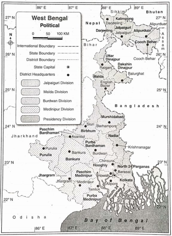
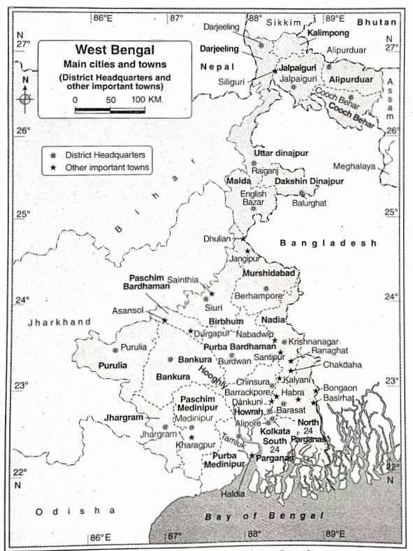
west Bengal is divided into 23 districts. The districts are divided into sub-divisions and blocks. Apart from this, the districts are also divided into five administrative divisions namely Presidency, Burdwan, Jalpaiguri, Medinipur, and Malda.
The districts of West Bengal and their headquarters are (listed in the following table—
| Administrative Division | Name of the District | Area (sq. km| | Population 1 (2011) | Density (per sq. km) | Headquarters | Founding Year |
| 1. Jalpaiguri division | Jalpaiguri | 2844 | 3872846 | 622 | Jalpaiguri | 1947 |
| Alipurduar | 3383 | 1700000 | 400 | Alipurduar | 2014 | |
| Darjeeling | 3149 | 1846823 | 586 | Darjeeling | 1947 | |
| Cooch Behar | 3387 | 2819086 | 832 | Cooch Behar | 1950 | |
| Kalimpong | 1054 | 251642 | 239 | Kalimpong | 7017 | |
| 2. Malda division | Murshidabad | 5324 | 7103807 | 1334 | Berhampore | 1947 |
| Uttar Dinajpur | 3140 | 3007134 | 958 | Raigan, | 1992 | |
| Dakshm Dinajpur Malda | 2219 | 3988845 | 755 | Balurgnat English Bazar | 1992 | |
| 3. Burdwan division | Birbhum | 4S45 | 3502404 | 771 | Source | 1947 |
| Hooghly Purba Bardhaman | 3149 | 5519145 | 1753 | Chinsurah | 1947 | |
| 5433 | 4835532 | 890 | Bardhaman | 2017 | ||
| Paschlm Bardhaman | 1603 | 2882031 | 1798 | Asansol | 2017 | |
| 4. Medinipur division | Bankura | 6882 | 3596674 | 522 | Bankura | 1947 |
| Purba Medinipur | 4736 | 5095875 | 1076 | Tamluk | 2002 | |
| Paschim Medinipur | 9345 | 5913457 | 633 | Medinipur | 2002 | |
| Puruiia | 6259 | 2930115 | 468 | Puruiia | 1956 | |
| Jhargram | 3038 | 1136548 | 370 | Jhargram | 2017 | |
| 5. Presidency division | North 24 Parganas | 4094 | 0.10009781 | 2444 | Bara sat | 1986 |
| South 24 Parganas | 9660 | 8161961 | 844 | Alipore | 1986 | |
| Howrah | 1467 | 4850029 | 3306 | Howrah | 1947 | |
| Nadia | 3927 | 5167600 | 1315 | Krishnanagar | 1947 | |
| Kolkata | 185 | 4496694 | 24306 | Kolkata | 1947 |
Question 4 Discuss the importance of West Bengal as a state.
Answer:
Importance of West Bengal as a state: West Bengal has immense importance as a state because of the following reasons
1. Area: West Bengal comprises about 2.7% of the total area of India.
2. International border: West Bengal has an international border with Bangladesh, Nepal, and Bhutan. Pertaining to the length of the international border, West Bengal ranks second in India.
3. Population: In terms of population, West Bengal ranks fourth in the country and comprises about 7.5% of the total population of India.
4. Population density: West Bengal has the second highest population density (1029 persons per sq. km) just after Bihar.
5. Agricultural production: Among all the states of India, West Bengal occupies the top position in the production of rice, jute, and fish. In the case of potato and tea production, West Bengal ranks second whereas, for coal mining, it occupies the seventh position.
6. Industry: West Bengal has a significant position in case of iron and steel industry, engineering industry, and tea industry.
7. Commercial position: Kolkata, the capital of West Bengal, is the second largest city in India (in terms of population). Apart from this, it is also the largest commercial center in eastern India. Kolkata has the largest commercial port and an international airport.
8. Diverse physical features: West Bengal is the only state in India where both the Himalayan mountain range and the Bay of Bengal are found. Apart from these, flood plains, plateaus, rivers & islands are also found here.
Question 1 Describe the rivers of West Bengal.
Answer:
Rivers of West Bengal:
The rivers are divided on the basis of source, the direction of flow, the amount of water carried, type of delta, etc.
The divisions are as follows—
1. Rivers of North Bengal,
2. Ganga and its tributaries running through the central part,
3. Rivers of the western plateau and Rarh region,
4. Southern Sunderban region and its rivers,
5. Rivers of the sandy areas of the Kanthi region.
1. Rivers of North Bengal: The rivers of North Bengal are snowed. They originate from the Himalayan region and flow from north to south according to the slope. The rivers are Teesta, Jaldhaka, Mahananda, Sankosh, Raidak, Torsa, etc.
1. Teesta: It originates from the Jemu glacier in the Sikkim Himalayas. Teesta is the main river of North Bengal, flows through the districts of Darjeeling and Jalpaiguri, and drains into the Jamuna in Bangladesh.
2. Jaldhaka: It rises from the hilly regions of the Sikkim-Bhutan border and flows through the districts of Jalpaiguri and Cooch Behar before draining into the Jamuna in Bangladesh.
3. Mahananda: This river rises in the Darjeeling Himalayas, flows south, and drains into the Ganga. Balaton river is its tributary.
2. Ganga and its tributaries running through the central part: The main river of West Bengal is the Ganga. It emerges from the Gangotri glacier near Gomukh in Uttarakhand and traverses a great distance before entering West Bengal through Dhulian in Murshidabad. Here, the river gets divided into two parts, one is the Hooghly river in West Bengal and the other enters as Padma in Bangladesh. The Hooghly river flows south and drains into the Bay of Bengal. The distributaries of Ganga and Padma are Ichamati, Churni, Jalangi, etc.
3. Rivers of the western plateau and Rarh region: These rivers are rain-fed. The slope of the land is from west to east and southeast and the rivers originating from the Chota Nagpur Plateau flow accordingly.
The rivers of this region are—
Damodar,
Dwarkeswar,
Shilabati,
Kangsabati,
Ajoy,
Miayurakshi,
Dwarka, etc.
1. Damodar: The river rises from the Khamarpat Hills in the Palamau district of Jharkhand and drains in the Bhagirathi-Hooghly. One of its distributaries, Mundeswari drains into the Rupnarayan river.
2. Rupnarayan: It is the combined flow of rivers Dwarakeswarand Shilabati, both rise from the western plateau region and flow southwest. Rupnarayan drains into the Hooghly river.
3. Other rivers: Other important rivers of this region include the Kangsabati, Ajay, Mayurakshi, Dwarka, etc
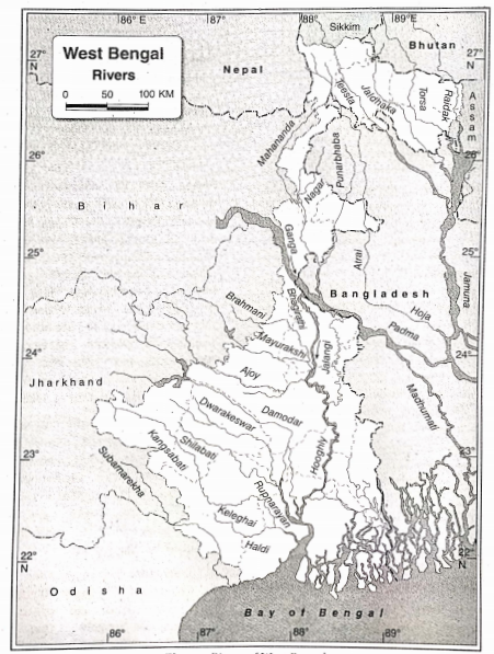
4. Rivers of Sundarbans: Numerous rivers of this region are tide-fed and flow towards the west. Saptamukhi, Matla, Raimangal, Bidyadhari, etc., are the rivers of Sundarbans.
5. Rivers of the Kanthi region: The rivers of this region are tide-fed. Rasulpur and Champa are the rivers of the sandy area of Kanthi.
Question 2: Describe briefly the rivers of North Bengal.
Answer:
Rivers of North Bengal:
Most rivers of North Bengal are fed by rainwater and glaciers. These rivers originate from different regions of the Himalayan range and according to the slope of the land, flow from north to south.
A brief description of the rivers of North Bengal is given below—
1. Teesta: It is the most important river in North Bengal. Teesta originates from the Jemu glacier, flows through the districts of Darjeeling and Jalpaiguri and finally drains into the Jamuna river of Bangladesh.
2. Jaldhaka: This river originates from the mountainous terrains of the Sikkim-Bhutan border, flows through the districts of Jalpaiguri and Cooch Behar and finally meets the Jamuna river in Bangladesh.
3. Mahananda: This river originates near the Mahaldiram Hills of the Himalayan range and flows southwards. It finally flows into the Ganga and its main tributary is the Balasun river.
4. Others: Some of the other notable rivers of North Bengal are Sankosh, Raidak, and Torsa.
Question 3 Describe the rivers of the plateau iSM region of West Bengal.
Answer:
Rivers of the plateau region of West Bengal
The characteristic features of the rivers in the plateau region of West Bengal are-
1. The rivers of the western plateau Most of the region are the tributaries of the Bhagirathi- Hooghly.
2. The rivers originated from the Chota Nagpur Plateau region.
3. Most of the rivers flow towards the east and southeast according to the slope of the land.
4. These are rain-fed rivers and thus their water content reduces in seasons other than monsoons.
The major rivers of this region are—
1. Damodar: It originates from the Khamarpat Hills of Palamau district in Jharkhand and joins river Hooghly downstream. One of its distributaries, Mundeswari, drains into the Rupnarayan. Damodar was a flood-prone river before the conceptualization of the Damodar Valley Project, and was thus known as the ‘Sorrow of Bengal’.
2. Kasai or Kangsabati: It originates from the Ajodhya Hills of the Purulia district and flows to the southeast to meet the river Keleghai. The combined flow of these two rivers is river Haldi, which meets river Hooghly. Kumari river is a tributary of this river.
3. Dwarakeswer and Shilai, or Shilabati: The combined flow of these two rivers near Ghatal in Paschim Medinipur is known as Rupnarayan. (It then meets river Hooghly near Geonkhali in Purba Medinipur.
4. Mayurakshi: It originates from the Chota Nagpur Plateau and flows through the state of Jharkhand. Later it enters the Birbhum district of West Bengal and joins river Bhagirathi at the end. The right bank tributaries of river Mayurakshi include Bakreswar and Kopai, and the left bank tributaries are Brahmani and Dwarka.
5. Ajoy: It originates from the Chota Nagpur Plateau and flows through the southern boundary of Birbhum district and then meets river Bhagirathi near Katwa in Purba Bardhaman district.
6. Others: Another important river of this region is Subarnarekha. It originates from the Chota Nagpur Plateau in Jharkhand and flows through the southern part of the Jhargram district of West Bengal and Odisha and then drains into the Bay of Bengal.
Question 4 Give a brief description of the rivers flowing through the Rarh Plain and the Ganga Delta region. Write the characteristics of the rivers of the Sundarban region.
Answer:
Rivers of the Rarh Plain: Most rivers of the Rarh Plain originate from the Chota Nagpur Plateau and flows across the western plateau region. These rivers either flow from west to east or from west to southeast.
Some important rivers of the Rarh Plain are briefly described below—
1. Damodar: This river originates from the Khamarpat Hills of the Palamu district in Jharkhand. It flows through the western plateau and the Rarh Plain and drains into the Bhagirathi-Hooghly river. Mundeswari, a distributary of Damodar flows into the Rupnarayan river.
2. Rupnarayan: The rivers Dwarekeswar and Shilai (or Shilabati) meet near Ghatal to form the Rupnarayan river. This river finally drains into the Hooghly river near Geonkhali.
3. Others: Some other notable rivers of this region are—
Kangsabati,
Ajoy,
Bakreswar,
Mayurakshi, and
Dwarka.
Rivers of the Ganga Delta region:
The Bhagirathi-Hooghly river is the most important river in this region. It flows through the western margin of the deltaic region in a north-south direction. Some rivers of this region which flow to the east of the Bhagirathi-Hooghly are Bhairab, Jalangi, Mathabhanga, Ichamati, and Churni. These rivers flow from north to south as per the slope of the land. The rivers, Bhairab, Jalangi, and Mathabhanga are the distributaries of the river Padma. Among these, Mathabhanga and J’alangi have drained into the Bhagirathi river. The southern part of the Mathabhanga river is called Churni. Ichamati is the distributary of Mathabhanga which finally drains into the Bay of Bengal. The slope of the Ganga Delta region is low and so the rivers here take a meandering course and form many estuaries, creeks, and water bodies.
Some other rivers of the Sundarban region which are fed by tidal water are—
Raimangal,
Malta,
Gosaba, and
Bidyadhari, etc.
Characteristics of the rivers of the Sundarban region: Most rivers of the Sundarban region are fed by tidal water, such as-
Saptamukhi,
Malta,
Raimangal,
Bidyadhari, etc.
The characteristics of these rivers are—
1. The rivers are perennial as they are tide-fed.
2. The rivers have saline water.
3. The length of these rivers is short i.e., they have a short course.
4. These rivers have formed estuaries.
5. The mouth of these rivers are quite wide.
6. These rivers finally drain into the Bay of Bengal.
Question 1 Write a note on the characteristics of the climate of West Bengal. In which region of West Bengal are winter clothes required even in summer?
Answer:
Characteristics of the climate of West Bengal: The main characteristics of the climate of West Bengal are—
1. Change of seasons: The main characteristic of the climate of West Bengal is the season change. Summer, monsoon, autumn, and winter are the four main seasons of West Bengal, that change in a cyclical way. Apart from that, before the arrival of winter, the dewy season is observed is known as late autumn, while spring marks the beginning of summer
2. Extensive impact of tropical monsoon wind: In summer the hot southwestern monsoon winds and in winter the dry north-eastern monsoon winds blow over the state. These two winds bring hot-humid summers and cold-dry winters in West Bengal, respectively.
3. Opposite direction of winds: In West Bengal, the direction of the wind in summer is opposite to the direction of the wind in winter.
4. Wet summer and dry winter: Generally rainfall occurs in summer, so the summer is basically wet and humid. On the other hand, winter is dry in West Bengal. But a little amount of rainfall occurs due to western disturbances.
5. Northern region is rainfall prone: As a result of the southwest monsoon winds, stations in West Bengal receive heavy rainfall in its Northern Himalayan region. The hilly regions of West Bengal receive an average rainfall of 400 cm annually
6. Entire West Bengal except the mountainous region has a moderate type of climate: As the northern part of West Bengal is a mountainous area, summers are pleasant here but winters are bitterly cold. In the rest of West Bengal, the annual range of temperature is not very high. A pleasant climate prevails in the plains and coastal regions. The western plateau area (especially Purulia) experiences high summer temperatures. In the Darjeeling district of the northern mountainous region, summer temperature (16°C) being low, winter clothes are required in the summer as well. The temperature rapidly decreases here at night. Darjeeling in the northern region of West Bengal requires winter clothes even in summer.
Question 2 Give an account of the climatic characteristics of different seasons in West Bengal.
Answer:
The climate of West Bengal in different seasons: Indian Meteorological Department has classified the climate of West Bengal into four types. They are summer, monsoon, autumn, and winter. The late autumn season just before the onset of winter and the spring season just before the onset of summer is also noticeable.
1. Summer:
1. Duration: This season lasts from March to May. As the Sun moves towards the Tropic of Cancer from the Equator, the temperature in West Bengal gradually increases.
2. Characteristics:
1. About 30°C is the standard normal temperature of West Bengal during summer. But in the western plateau region, the temperature reaches up to 45°C. Purulia district Xperience the maximum temperature and a dry hot wind called ‘loo’ is rampant during this season here,
2. Since the mountainous areas have high altitudes, temperatures are low here and the coastal regions experience moderate or maritime climates. The temperature in the mountainous area of Darjeeling is 12°C-18°C.
3. Thunderstorms accompanied by lightning called ‘Kalbaishakhi’ are a common feature that usually occurs during afternoons in the summer season. Rainfall is often accompanied by hailstorms.
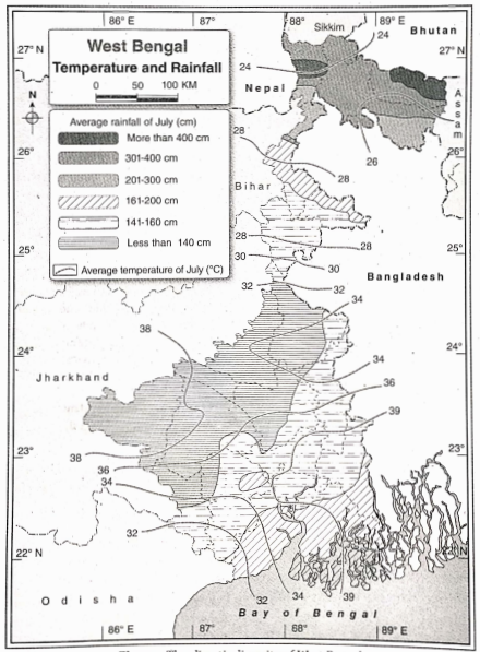
2. Monsoon:
1. Duration: This season lasts from June to September. The rainy season usually convenes in early June. It establishes itself in West Bengal with heavy rainfall, starting from the second week of June with the entry of moisture-laden southwest monsoon wind.
1. Characteristics:
1. Under the influence of the moisture-laden monsoon winds, the highest amount of rainfall is experienced in the mountainous region of the north (an average of about 400 cm),
2. The rainfall amount gradually decreases towards the south. In the plains of North Bengal it is 200-250cm and in the delta region it is 150-200cm. But the coastal regions receive a comparatively higher amount of rainfall,
3. The average rainfall amount in the rainy season is 175 cm in West Bengal,
4. The Highest amount of rainfall is recorded in the Buxaduar region (535cm) and the least amount in the PuruSia district (75 cm). Compared to the summer season, the temperature is quite low during this time.
3. Autumn:
1. Duration: This season lasts from October to November. Autumn arrives when the Sun moves from the Equator to the Tropic of Capricorn, i.e., at the end of September and the beginning of October.
1. Characteristics:
1. The south-west monsoon winds retreat from West Bengal which results in decreasing amount of rainfall,
2. The average temperature in this season is about 30°C.
3. During the retreating monsoon season, thunderstorms having their origin in the Bay of Bengal are common. These thunderstorms are known as ‘Ashwiner Jhar’.
4. Winter:
1. Duration: Winter in West Bengal lasts from December to February. The sun is directly overhead the Tropic of Capricorn during this time.
Characteristics:
1. Cold and dry north-east monsoon winds begin to blow during this period,
2. The temperature of West Bengal is much lower during this time (it is 4°C-7°C in the mountainous region, 16°C and 10°C in the southern and western parts of the state respectively),
3. Generally winter is dry in West Bengal and the weather is stable,
4. Occasionally a little rainfall occurs under the influence of low depressions in northwest India. These are known as ‘western disturbances’.
Question 3 Explain the influence of monsoon winds on the climate of West Bengal.
Answer:
Influence of monsoon Winds on the climate of West Bengal:
Two different types of winds blow over West Bengal—
1. Humid south-west monsoon wind that blows during summer, and
2. Dry northeast monsoon wind that blows during winter. These two winds are mainly responsible for regulating the climate of West Bengal.
1. Change of season:
The climate of West Bengal can be divided into 4 seasons according to the onset and retreat of these two wind systems.
These are—
1. Pre-monsoon or summer season,
2. Monsoon or rainy season when the south-west monsoon winds are active,
3. Retreat of the south-west monsoon winds or autumn season, and
4. Onset of northeast monsoon winds or winter season.
2. Determine climatic characteristics: Not only the demarcation of seasons but also the climatic characteristics of West Bengal are influenced by the nature of monsoon winds.
3. Low temperature during winter: The northeast monsoon winds blow from the north towards the south during winter (from December to February). Since these winds are cold, the temperature drops in West Bengal and it is known as the winter season. Rainfall does not occur in this season as these winds are dry.
4. High temperature during summer: The northeast monsoon winds start retreating from West Bengal at the end of February and the southwest monsoon winds arrive during the interim period (from March to May). As a result, the temperature rises, and this period is known as summer.
5. Excessive rainfall during the rainy season: The southwest monsoon wind blows over West Bengal from June to September. Since this wind is moisture-laden, the sky is overcast and rainfall occurs. This season is called the rainy season or monsoon season.
6. Clear sky during autumn: From October to November, the southwest monsoon winds retreat. As a result, the sky becomes clear and the temperature gradually decreases.
Question 1 Write the classification of soil in West Bengal and describe them in brief.
Answer:
Classification of soil in West Bengal:
According to soil scientists soil is formed by the combined effect of climate, biosphere, relief, parental rock, and time. For the variation of these soil-forming elements, the soil of West Bengal can be classified into different types.
They are—
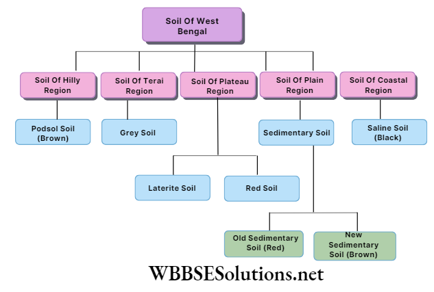
1. Soil of hilly region:
1. Location: This type of soil is mostly found in the districts of Darjeeling, Jalpaiguri, Alipurduar, parts of Cooch Behar, etc.
2. Characteristics:
1. This is a type of podsol soil,
2. This soil is mostly brown in color,
3. The fertility of this soil is medium.
4. Crops produced: Tea, orange, cinchona, etc. are cultivated in this soil.
2. Soil of terai region:
1. Location: This type of soil is found at the foothills of the Himalayas.
2. Characteristics:
1. This type of soil is full of pebbles,
2. This soil is grey in color,
3. The soil fertility is medium.
3. Crops produced: Paddy, wheat, tea, and potato are cultivated in this soil.
3. Soil of plateau region:
1. Location: This soil is mostly found in Purulia, Bankura, Birbhum, Paschim Bardhaman, Paschim Medinipur, Jhargram, and Dakshin Dinajpur.
3. Characteristics:
1. In this region, mostly two types of soil are found laterite soil at the west and red soil at the east,
2. Laterite soil is red in color and hard as a brick. This soil is infertile and the water holding capacity is very low.
3. Red soil is also red in color. The texture of this soil is fine and the iron content is very high. The water holding capacity of this soil is low and that is why for cultivation irrigation is very important.
3. Crops produced: Paddy (in a small amount), corn, potato, tobacco, etc. are the main crops produced.
4. Soil of the plain region:
1. Location: This type of soil is mostly found in Uttar Dinajpur, Murshidabad, Nadia, Purba Bardhaman, North and South 24 Parganas, Howrah, Hooghly, etc.
2. Characteristics:
1. This type of soil is mostly acidic in nature,
2. This soil is mainly formed by the deposition of rivers. So, the amount of silt, sand, and clay is high ‘in this soil,
3. This is fertile soil, mostly known as sedimentary soil or alluvial soil,
4. The old sedimentary soil is red in color and less fertile. On the other hand, new sedimentary soil is brown in color and more fertile.
3. Crops produced: Paddy, wheat, jute, sugarcane, etc. are the main crops.
5. Soil of coastal region:
1. Location: This type of soil is mainly found in the Sundarbans and Kanthi coastal regions in West Bengal.
2. Characteristics:
1. This soil is saline in nature,
2. The texture of this soil is very fine,
3. Water holding capacity of this soil is low.
4. This soil is black in color and infertile in nature.
3. Crops produced: In this soil, the amount of salt is very high. That is why, with the help of rainwater harvesting the salinity of the soil is controlled which helps to cultivate crops like paddy (in a small amount), vegetables, coconut, betel nut, watermelon, etc.
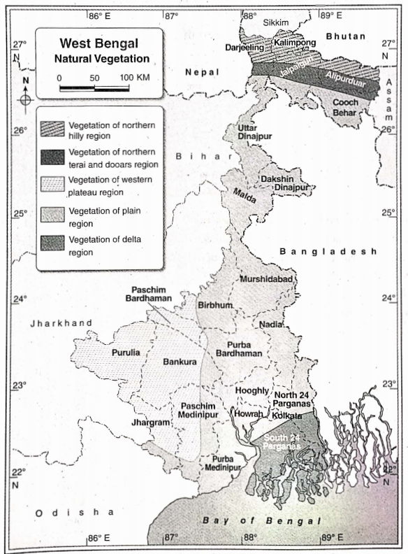
Question Describe the natural vegetation of west Bengal.
Answer:
Natural Vegetation of West Bengal:
West Bengal is a monsoon-dominated state. So, the natural vegetation is directly influenced by the monsoon climate.
1. Vegetation of northern hilly region:
Location: Darjeeling, Jalpaiguri, Alipurduar, Kalimpong districts.
3. Evergreen trees: These trees are grown up to an altitude of 1000 m from the foothills. The main trees in this category are sal, Segun, Shishu, Marjan, bamboo, etc.
2. Temperate deciduous and coniferous trees: Temperate forest is found mainly between 1000m to 3000m altitude. Between this region, deciduous trees are grown in the lower altitudes, and coniferous trees are grown in the upper altitudes. The important trees of this region are oak, maple, pine, spruce, deodar, birch, etc.
3. Alpine trees: These trees are grown between 3000 m and 4000 m of altitude. The mostly found trees are silver pine, rhododendron, etc.
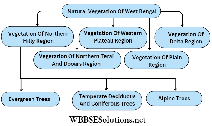
2. Vegetation of northern terai and doors region:
3. Location: Terai and doors regions of Darjeeling, Jalpaiguri, and Alipurduar districts.
3. Characteristics:
1. Due to the high amount of rainfall, the trees are evergreen in nature,
2. The forest is concentrated at the foothills of the mountains.
3. Main trees: Sal, Segun, Khair, cane, bamboo, etc.
3. Vegetation of the western plateau region:
3. Location: Purulia, Bankura, Paschim Medinipur, Paschim Bardhaman, Jhargram, the western part of Birbhum district, etc.
3. Characteristics:
1. Trees of this region lose their leaves in the dry season,
2. This forest is called a deciduous forest,
3. This forest is not dense.
3. Main trees: Arjun, shimul, sal, Palash, mahua, etc.
4. Vegetation of plain region:
3. Location: Uttar and Dakshin Dinajpur, Malda, Murshidabad, North and South 24 Parganas Purba and Paschim Medinipur, Purba Bardhaman, Howrah and Birbhum districts.
3. Characteristics:
1. The forest in this region is dispersed in nature,
2. Trees are mainly deciduous in nature,
3. Trees are medium in size and they are mainly hardwood trees
4. This forest has been mostly cleared because of population and agriculture.
3. Main trees: Banyan, mango, tamarind, bel, Jamun, asthma, jackfruit, etc.
5. Vegetation of the delta region:
1. Location: North and South 24 Parganas, the coastal areas of the Bay of Bengal
2. Characteristics:
1. These trees are mainly grown in saline soil.
2. They have breathing roots and stilt roots.
3. Viviparous germination is found in these trees.
4. These trees are commonly known as mangrove trees.
3.Main trees: Sundari, garart, geoa, (netal, hogla, keora, etc.
Question 1 What are the reasons for the development of industries in West Bengal?
Answer: Reasons for the development of industries in West Bengal: Among all human activities, industrial development is the most prominent one. Industries help to process different types of raw materials into various useful commodities that are beneficial for mankind.
The factors causing industrial development may be grouped onto two types—
1. Geographical factors and
2. Economic factors.
1. Geographical factors: The geographical factors behind the improvement of industries in West Bengal are as follows—
1. Importance of raw materials: Raw material is the most important factor for industrial development. Certain characteristics of raw materials are important—
1. Nature of utility of raw materials,
2. Erishability of raw materials,
3. Use of alternative raw materials.
2. Availability of power/energy: Energy is required to run the equipment for processing the raw materials. Thermal power and hydroelectricity are the two most widely used powers.
3. Congenial climate: Certain industries need specific climatic conditions. For example—a dry climate for the leather industry, a sunny climate for the film industry,
4. Supply of water: A large amount of water is required for any industry. Teesta, Torsa, Jaldhaka, Raidak, Damodar, Mahananda, and Bhagirathi- Hooghly are the major rivers of West Bengal. Thus an adequate supply of water is also a favorable factor for the development of industries.
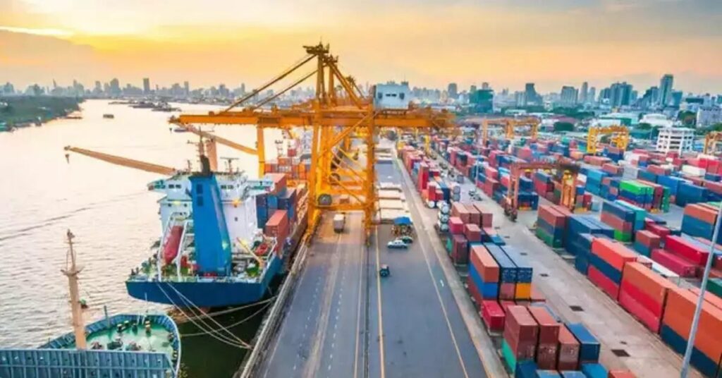
5. Presence of Kolkata and Haldia ports: The presence of parts like Kolkata and Haldia helps in international trade through waterways. Import of machinery and other necessary equipment and export of finished products of different industries via these ports create a favorable environment for the establishment of industries in West Bengal.
2. Economic factors: Most important economic factors for the development of industries in West Bengal are as follows—
1. Advanced transport system: Since the raw materials have to be brought to the industrial sites and the finished products are to be taken to the domestic markets as well as for export, the transport system plays a vital role. Developed transport networks and accessibility are therefore important factors for industrial development.
2. Availability of labor: Labour is essential for industrial development. The abundance of skilled labor is important for industrial development. Since West ‘ Bengal is densely populated, labor is readily available.
3. Huge capital: Capital is needed for acquiring land for industries, bringing equipment, wages for laborers, and procuring raw materials. Various governmental and non-governmental institutions have invested huge capital in industrial development in West Bengal.
4. Falta and Kulpi in south 24 parganas,
1. Leather complex at Bantala in Kolkata,
2. Monikanchan SEZ (Saltlake) in Kolkata,
4. Saltlake electronic city in Kolkata.
5. Demand and market: If there is no demand for a particular commodity, production of that commodity is not required. This is the reason why demand and accessible markets are important factors for the development of industries. Products that are produced on an industrial farm in West Bengal have a huge market in India.
3. Political stability: Industrialists can invest in establishing industries if there is political stability instead of frequent change of power in any country or state.
Question 2 Give an account of the main industries of West Bengal.
Answer: Main industries of West Bengal: Although West Bengal is mainly an agricultural state, industries have also flourished here. The main industries of West Bengal are- iron and steel, jute and tea, food processing, cotton textile, tourism, information technology (IT), etc.
1. Iron and steel industry: The first iron and steel industry was established in Kulti (Paschim Bardhaman) in 1870. Another one was established in Burnpur in 1918. The Durgapur industrial belt has developed due to the abundant availability of iron ore, coal, water, electricity, labor, etc., in this region.
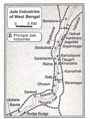
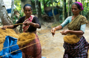
2. Jute industry: West Bengal is the leading producer of jute in India. The first jute industry was established in 1855 in Rishra (Hooghly district). At present, there are about 59 jute mills located on either side of river Hooghly.
3. Cotton textile industry: The cultivation of cotton does not take place in West Bengal, but based on the imported cotton, the cotton textile industry has developed here. The first cotton-textile industry was established in Ghusuri (Howrah district). Other centers are in Serampore, Shyamnagar, Sodepur, etc.
4. Tea industry: This is an important industry in West Bengal. The first tea industry was established in 1834. Tea estates were established in Darjeeling, Jalpaiguri, Cooch Behar, etc., There are about 343 tea estates in West Bengal.
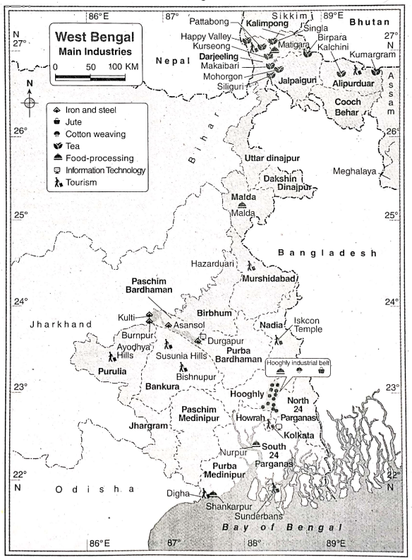
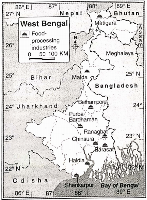
5. Food processing industry: The food processing industry has developed in West Bengal due to its great demand. Kolkata, Shankarpur, Dumdum, Barasat, and Malda are the main food processing centers in West Bengal.
6. Tourism industry: The tourism industry has developed around various centers like religious places, hilly areas, sea beaches, educational centers, big cities, historical places, etc. Important tourist places of West Bengal are=Koikata (Victoria Memorial, Alipore Zoo, etc.), Sundarbans, Digha, Darjeeling, etc.
7. Information technology industry: This industry has developed in West Bengal and holds an important position in the state. The Electronics Complex (Software Park) of -Salt Lake near Kolkata is famous and further development of this industry is taking place here.
Question 4 Discuss the factors leading to the development of the iron and steel industry in West Bengal.
Answer: Factors leading to the development of the iron and steel industry in West Bengal: The main factors that have led to the development of the iron and steel Industry in West Bengal may be grouped into two types—1. Geographical factors, 2. Economical factors.
1. Geographical factors: Main geographical factors that help to develop iron and steel industries in West Bengal are as follows—
1. Accessibility of raw materials: Ramiganj, Andal, etc. of Paschim Bardhaman are important coal mines of West Bengal. Jharia, India’s largest coal mine is located near West Bengal. Thus coal is easily available in this region. In addition to this iron ore and limestone are also available in this region which helps to develop the iron and steel industry in West Bengal.
2. Favourable climate: The climate of West Bengal is ideal for growing jute. It helps to develop the jute industry in this state.
3. Availability of power sources: Easy availability of power in West Bengal has contributed much to the growth of the jute industry here.
2. Economic causes:
The main economic causes are as follows—
1. Developed communication system: West Bengal is well-connected to the rest of India through roads, railways, and waterways. This plays an important role in the development of the jute industry.
2. Availability of labor: The availability of cheap labor from West Bengal and its neighboring states like Bihar, Jharkhand
, and Odisha has helped in the development of the jute industry.
3. Port facility: The port at Kolkata in West Bengal facilitates the export of jute products and the import of necessary equipment, which further helps in the development of the jute industry.
Question 5 Discuss the problems and prospects of the iron and steel industry of West Bengal.
Answer: Problems of the iron and steel industry:
The main problems of the iron and steel industry of West Bengal are—
1. Unavailability of raw materials when required: Since only coal is available in West Bengal, other raw materials of the iron and steel industry have to be brought from Jharkhand and Odisha. Thus raw materials are not always available as needed. It results in low productivity.
2. Lack of modern technology: Lack of modern technology and equipment are the main problem for the development of iron and steel industries in West Bengal.
3. Unavailability of adequate skilled labor: Although there is an abundance of laborers in West Bengal the number of adequate skilled laborers is very less. It is one of the major constraints for the development of the iron and steel industry.
Question 6 Give an account of the cottage industry of West Bengal.
Answer: Cottage industries in West Bengal: The industry which is involved in the production of goods made by the members of the household with little capital investment and ordinary equipment is known as the cottage industry. Lakhs of people in West Bengal are engaged in cottage industries and the role of those industries has a major contribution, especially in the rural economy.
The various industries here include—
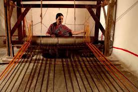
1. Cotton textile industry (‘Tant’): A majority of the people engaged in the cottage- industries are working in the ‘Tant’ industry. In West Bengal, about 6,66,514 people are engaged in this industry either on a full-time or a part-time basis. These textiles are usually woven by hand-driven machines or gadgets. Shantipur and Phulia of Nadia district and Dhanekhali of Hooghly district, Bankura, and Bishnupur are famous for this type of industry. engaged in this industry either on a full-time or a part-time basis. These textiles are usually woven by hand-driven machines or gadgets. Shantipur and Phulia of Nadia district and Dhanekhali of Hooghly district, Bankura, and Bishnupur are famous for this
type of industry.
Clay industry: Kumartuli of Kolkata is famous for making clay idols, Krishnanagar for clay dolls, and Bankura and Bishnupur for terracotta products. Moreover, almost everywhere in the state of West Bengal, clay utensils, pots, etc., are made (especially in the villages) and many people are engaged in it.
3. ‘Bidi’ industry: ‘Bidi’ is made by, filling tobacco into dried ‘kendu’ leaves which are collected from the forests. A large number of people of West Bengal depend on ‘bidi’ making for their livelihood. Aurangabad, Raghunathganj of Murshidabad district, North and South 24 Parganas and Purulia district abound in such a ‘bidi’ making industry.
4. Mat industry: The sticks used for making mats are actually a type of aquatic plant. This industry is famous in Purba and Paschim Medinipur districts.
5. Jute products: Many articles like threads, ropes, carpets, mattresses, bags, and other decorative items for households are produced from jute in the villages of West Bengal. Kaliganj of Nadia district is well known for the weaving of jute fibers and dyeing them.
6. Wooden furniture: Many carpenters in West Bengal are engaged in making beds, wardrobes, chairs, tables, benches, doors, windows, etc.
7. Articles made from iron: Articles like sickles, hammers, axe, spades, plows and other household items are made from iron.
8. Others: Besides these, many industries like molasses-making, silk industry, bamboo products, making of musical instruments, toys as well as articles made of brass and bronze, machines used in rice mills, etc., are scattered all over West Bengal.
Question 7 Discuss the importance of small-scale industries in West Bengal.
Answer: Importance of small-scale industries: Small-scale industries are a grade higher than cottage industries. The total financial investment ranges from Rs.75 lakhs to 1.5 crores involving the construction of small factories, machines, etc. Small-scale industries are very significant in West Bengal.
The importance of small-scale industries is as follows—
1. Financial investment: Investments in small-scale industries are of medium range. However, the overall financial investment is quite large indicating the importance of such industries.
2. Employment: Many people are employed in small-scale industries which has led to the economic development of West Bengal. About 20 lakh people are engaged in the leather industry alone.
3. Huge exports: A large market has developed for the products of small-scale industries both in India and abroad. Thus, a huge amount of foreign exchange is earned from this industry. Items like leather goods, silk, cotton textile, gold jewelry, ceramic products, etc., are especially exported.
4. Development of domestic trade and commerce: As a result of the flourishing small-scale industries, domestic or internal trade and commerce have increased. It is helpful for the economic development of the country.
5. Increase in infrastructure: Roads, electricity, water supply, and other infrastructural facilities have developed around any area where small-scale industries are developing.
Question 8 Discuss the development of the food processing industry in West Bengal.
Answer: Development of the food processing industry in West Bengal: The food processing industry is one of the oldest industries in the history of mankind. At present, various food processing industries have developed in Kolkata, Barasat, Malda, Shankarpuir, Paschim Bardhaman, Dumdum, etc.
The causes of the development of the food processing industry in West Bengal are—
1. Supply of high-quality raw materials: Varieties of agricultural crops(grains, vegetables), animals, and seafood are the raw materials of the food processing industry. The adequate supply of these raw materials has helped in the development
of the industry.
2. Development of technology: Food products are perishable. To maintain the quality of the products, high technology is required, which is available in West Bengal.
3. Development of transport system: The process of gathering fish, meat, and fruit which rot fast have to be produced in the processing house with the help of a good transport system which is available in West Bengal.
4. Food habits: The demand for processed food is high in West Bengal. This makes it a flourishing center for the food processing industry.
5. Government policy: Government policies are quite favorable towards food processing industries in West Bengal.
Question 9 What is the tourism industry? What are the causes of the development of the tourism industry in West Bengal?
Answer: Tourism industry: When people travel from one place to another for entertainment, leisure, business, and educational purposes and attain satisfaction, it is called tourism. When the development of infrastructural facilities like roads, hotels, resorts, etc., are made for such purposes, it is then considered an industry.
Causes of development of tourism industry in West Bengal: Main causes of the development of the tourism industry in West Bengal are—
1. Diversity in the physical environment: The lofty and majestic Himalayan mountains in the north, the beautiful Bay of Bengal to the south, the physical features of the western plateau, Terai, Dooars of the northern part, and Sundarbans of the southern part provide an exquisite variety of natural or scenic beauty in West Bengal which has led to the development of tourism industry here.
2. Historical and cultural centers: Historical, cultural, and religious centers like Haldia; Murshidabad, Kolkata, Santiniketan, Bandel, Imambara, etc. attract tourists from different parts of the world.
3. Transport facility: All the major tourist centers are connected with a good network of roads, railways, airways, waterways, air-conditioned buses, helicopters, steamers, etc. These have benefited tourists to travel from one place to another.
4. Development of hotels and resorts: New hotels and resorts have come up in historical places. Eco-resorts and tree houses are attracting tourists in the Terai and Oooars in the northern and Sundarbans in the southern part of the state.
5. Tourist guides: The tourist guides make people aware of the tourist places, such as the importance of these places and the conservation of heritage sites, etc. They aid in the development of the tourism industry.
6. Local festivals: Sharadiya Festival of Kolkata, Poushmela of Santiniketan, Jagadhatri Puja of Chandannagar, Kolkata’s New Year celebration, etc., have led to the development of the tourism industry.
Question 10 What is the Information Technology industry? What are the causes of the development of the IT industry in West Bengal?
Answer: The information Technology industry: Collection of data, their analysis, research, change, and modification by using computers and telecommunication is called the Information Technology (IT) industry.
The main parts of the IT industry are—
1. Production of software,
2. Telephone,
3. Data collection and its preservation or storage,
4. Exchange of data and information.
Causes of development of the IT industry:
The main causes of the development of the IT industry in West Bengal are—
1. Abundance of human resource: Human resource is the main resource of this industry. Knowledge of software, hardware, etc., imparted to students from the school level has contributed to the development of this industry.
2. Availability of vocational training: In West Bengal, vocational training related to Information Technology is imparted in quite a number of reputed institutions. Many skilled workers are the products of these institutions.
3. Outsourcing: Most of the IT work comes from foreign countries. Thus, work from foreign countries can be done sitting at home in West Bengal itself. The profit earned by foreign countries is very large since the work is done at a much cheaper rate.
4. Sufficient investment: Big companies like IBM, TCS, Infosys, Wipro, and Siemens invest much capital in this industry. Besides them, other organizations have also come forward to invest nowadays.
5. Infrastructural development: Infrastructure and other amenities of Rajarhat, Salt Lake, Siliguri, Kalyani, etc., have been developed to a great extent by the Government of West Bengal. They include the development of roads, electricity, drinking water, transport, communication, etc. Thus, this industry has great potential in the coming days.
Question 1 What is the state?main cities and towns of West Bengal? Give an account of Kolkata as the
Answer: The main cities and towns of West Bengal:
The census of India has designated those places as cities that have the following criteria—a population of more than 5000, a population density of more than 400 persons per sq km, and at least 75% of the people engaged in non-agricultural activities.
The major cities of West Bengal include Kolkata, Darjeeling, Jalpaiguri, Siliguri, Alipurduar, Cooch Behar, Durgapur, Krishnanagar, Bolpur, Raniganj, English Bazar, Medinipur, Bankura, Malda, Bardhaman, Asansol, Haldia, Berhampore, Purulia, Shantipur, Chakdah, Ranaghat, Nabadweep, Balurghat, Chandannagar, Barrackpore, Howrah, Alipore, Barasat, Kalyani, Bongaon, Basirhat, etc.
Kolkata as the capital of West Bengal: Kolkata is the capital city of West Bengal. Thus it is of much importance in this state.
1. Location: The capital of West Bengal, Kolkata is situated on the left bank of river Hooghly about 130 km inland from the mouth of river Ganga. This is one of the most significant cities in India.
2. Year of establishment: Job Charnock, the governor of the East India Company established the city of Calcutta on August 24, 1690. The three villages of Sutanuti, Govindapur, and Kalikata were united to form this city. Calcutta was the capital of India under British rule till 1911. In 2001, the government of West Bengal decided to change the name of Calcutta to Kolkata officially. Information technology center Science City Jariavpur University Marble Palace

3. Importance of the city of Kolkata:
Kolkata is a very important city. Some of the important features of Kolkata are as follows—
1. Commercial capital: Having an area of about 185 sq. km, Kolkata is India’s main commercial center and the capital of West Bengal.
2. City of Palaces: Kolkata boasts of having quite a number of beautiful palaces and heritage buildings (like the Marble Palace of Raja Rajendra Mullick in north Kolkata, Rabindranath Tagore’s house in Jorasanko, Palace of Sovabazar, etc.). This is why Kolkata is known as the ‘City of Palaces’.
3. Population: Kolkata is one of the most important cities in India the city’s, population is about 4496694 (2011) and the population density is about 24306 persons per sq. km (2011).
4. Centre of education, culture, trade, and commerce: Kolkata is the main center of education, culture, trade, and commerce of east and north-east India.
5. Industrial center: Many industries have developed with Kolkata as its center, like, the jute industry, engineering industry, textile industry, paper industry, etc.
6. Centre of communication: Kolkata is the headquarter of the eastern and south-eastern railways. Dumdum, the only international airport in east India, is in Kolkata. National Highways like NH 2, NH 34, NH 35, and NH 6 alt pass through Kolkata.
7. Others:
Other significant features of Kolkata are—
(i) The only underground metro railway in eastern India is located here,
(ii) Kolkata is the main port of West Bengal,
(iii) The popular tourist spots of Kolkata are—Museum, Alipore Zoo, Victoria Memorial Hall, Birla Planetarium, Science City, etc.
(iv) As per the book entitled ‘City of Joy’ by the famous author Dominique Lapierre, the people of Kolkata are ever-happy in spite of all the sufferings endured by them. That is why it is called the ‘City of Joy’.
Question 2 Mention the major ports of West Bengal. State the importance of Kolkata port.
Answer: Major ports of West Bengal: The term ‘port’ has been derived from the Latin word ‘parte’ meaning ‘entrance door. In other words, a port means a place where entry is made between land and sea and also from sea to land through which transport or flow of goods and passengers is made. The major ports of West Bengal are Kolkata (located on the left bank of river Hooghly) and Haldia. They are riverine ports.
Importance of Kolkata port: Kolkata is a riverine port. About 130 km inland from the Bay of Bengal, it is located on the left bank of the river Hooghly. The hinterland of Kolkata port covers an area of about 13 lakh sq km. Kolkata port plays a vital role in the economic development of West Bengal.
1. Control over trade: Kolkata port has a very significant role in the economy of West Bengal) and even north-east India as well as Nepal and Bhutan. The exports and imports of this vast region are all handled by this port.
2. Earning foreign exchange: Since international trade is carried out through this port, the city earns foreign exchange.
3. Aid to industries: Products of West Bengal) like jute products, coal, tea (from Assam, Darjeeling), iron-ore (from Bihar and Odisha), mica, etc., are all exported from this port.
4. Aid to agriculture: Fertilisers, pesticides, equipment, etc., required for agricultural practices are imported through this port.
5. Employment opportunities: Lakhs of people are either directly or indirectly influenced by this port for getting employment opportunities in the agricultural, industrial, trade, and commerce sectors, etc. Besides, a large number of people also get employment as laborers within the port area itself.
6. Development of transport: Taking advantage of the Kolkata port, a good network of roads, railways, and water transport has developed not only in West Bengal but also throughout northeast India.
7. Import of food crops: Since West Bengal is not totally self-dependent on food crops produced in the state, a lot has to be imported through the Kolkata port. These are the reasons why the port of Kolkata is such a significant port among all other ports of West Bengal.
Question 3 Discuss the reasons for the rise and fall of Kolkata port.
Answer: Reasons for the rise or development of Kolkata port: The conducive factors leading to the development of Kolkata port are—
1. British interest: The port of Kolkata was established in the nineteenth century during the British period. They established it on the banks of river Hooghly in order to facilitate the transport of industrial raw materials, defense equipment, etc to India.
2. Navigability of Bhagirathi-Hooghly river: Since the depth of the river is more and the navigability of this river is quite high, ships could ply smoothly through this river to the sea.
3. Resource-rich hinterland: The Kolkata port has a huge hinterland encompassing almost the whole of eastern India. This region has rich natural resources like tea, jute, rice, etc., (agricultural) as well as coal, iron ore, mica, etc., (minerals), along with forest-based resources. Besides, the established industries of tea, jute, engineering, cement, paper, etc., have made this region densely populated.
4. Availability of labor: Kolkata is a densely populated metropolis, and laborers, required for port activities are easily available.
5. Developed transport system: Kolkata is linked to all parts of eastern India through a well-developed transport network like the south-eastern railway, national highways (like NH 6 and NH 34), etc.
6. Conducive physical environment: The areas in and around Kolkata have the advantage of having flat places and delta, congenial moderate climate, etc., which are all conducive to the development of a port.
7. Location of the center of trade: Kolkata being the main industrial and trade center of eastern India, has naturally developed as a port.
Reasons for the downfall of Kolkata port: This port is gradually losing its significance due to the following factors—
1. Decrease in navigability of Kolkata port: Due to continuous siltation on the river bed over a long period of time, the river bed has risen and therefore navigability has decreased. As a result, ships cannot ply much inland from the sea through this river.
2. Meandering nature of river: Numerous meanders of the river from its mouth to the Kolkata port, hinder the smooth plying of big ships inland.
3. Presence of huge sandbars in the river: The river has about 14-15 big sandbars stretching from the mouth of the river to Kolkata port. This is why large ships cannot enter Kolkata port easily.
4. Lack of space and infrastructure in the port: Due to lack of space, many ships cannot be anchored at the same time. Lack of jetties also hampers the loading and unloading of larger quantities of materials from ships. This industry helps in the economic development of West Bengal. The tourist sites of West Bengal are
Question 4 Discuss the various tourism sites of West Bengal.
Answer: Tourism sites of West Bengal: Traveling from one place to another either for business, leisure or for entertainment purposes is called tourism. Tourist guides, agencies, etc., are part of the tourism industry.
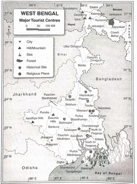
This industry helps in the economic development of West Bengal. The tourist sites of West Bengal are—
| Nature of tourist center | Centre | District | Places of attraction |
| 1. Town or city | 1. Kolkata | Kolkata | Victoria Memorial, Alipore Zoo, Museum, etc. |
| 2. Jhargram | Paschim Medinipur | Salbani, Jhargram Rajbari, etc. | |
| 3. Chandannagar | Hooghly | Laldighi, Aliadurg, French museum, house of Rashbehari Bose. etc. | |
| 4 Krishnanagar | Nadia | Rajbari. Roman Catholic church, etc. | |
| 2. Mountains and hills | 1. Darjeeling | Darjeeling | Rock garden. Tea gardens, Kangchenjunga, Tiger hill, etc. |
| 2. Ayodhya Hills | Purulia | Tribal house. Sitakunda. etc. | |
| 3. Susunia Hill | Bankura | Vishalakshi temple, Gandheswari river, etc. | |
| 3. Sea beaches | 1. Digha | Purba Medinipur | Sea beach, Amarabati park. Snake Park. etc. |
| 2. Shankarpur | Purba Medinipur | Sea beach, fishing port, etc. | |
| 3. Bakkhali | South 24 Parganas | Henry island, the temple of Banadevi. etc. | |
| 4. Forests | 1. Sundarbans | North and South 24 Parganas | Sagar Island. Sajnekhali, Lothian island. Mangrove forests (famous for Royal Bengal Tigers, mangrove trees, and other animal and plant species), etc. |
| 2. Jaldapara | Alipurduar | Jaldapara National Park (famous for one-horned rhinoceros, bison, elephant, etc.) | |
| 5. Historical places | 1. Bishnupur | Bankura | Rashmancha, Madanmohan temple, Chinnamasta temple. Lalbandh, Jamunabandh, etc. |
| 2. Plassey | Murshidabad | Mango orchard, Vijay Minar, House of Nawab, Hazarduarl, etc. | |
| 6. Religious places | 1. Belur Math | Howrah | Ramakrishna Math and Mission, Museum, etc. |
| 2. Ghutiari Sharif | South 24 Parganas | Gazi Baba’s bazar, Mecca pukur, etc. | |
| 3. Tarapith | Birbhum | Tarapith temple, crematorium on banks of Dwarka river, etc. | |
| 7. Cultural places | 1. Santiniketan | Birbhum | Visva-Bharati University. Tagore’s Ashram, Ballavpur Wildlife Sanctuary, Khoai, etc. |
| 2. Jorasanko Thakurbari | Kolkata | Thakurbari Museum (famous for antiques used by the Tagore family and Basanta Utsab. |
Chapter 8 West Bengal Short Explanatory Answer Type Questions
Question 1 Write a note on the location of West Bengal.
Answer:
Location Of West Bengal:-
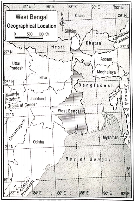
West Bengal is a state located in the eastern region of India. In terms of area, West Bengal holds the 14th position among the 28 states in India. The latitudinal extent of the state is 21°38’N from the south to 27°10’N to the north whereas the longitudinal extent is 85°50’E from the west to 89°50’E to the east. The Tropic of Cancer passes across the districts of Nadia, Purba Bardhaman, Bankura, and Purulia.
From north to south, West Bengal extends about 650 km, and from west to east, it extends about 325 km. West Bengal is surrounded by land on three sides and by sea on one side. West Bengal shares its boundary with Sikkim and Bhutan in the north. It is bounded by Bangladesh in the east, Assam in the northeast, the Bay of Bengal in the south, Odisha in the southwest, Nepal in the northwest, and Jharkhand and Bihar in the west.
Question 2 What Is the significance of the geographical location of West Bengal?
Answer:
West Bengal is located on the eastern side of India. The Himalayas are located to the north and the Bay of Bengal to the south of West Bengal.
The geographical location of West Bengal is significant in many ways—
1. The cold winds from the northern part are not able to reach West Bengal because of the location of the Himalayas which acts as a barrier in the north. It also protects us from foreign invasion.
2. The Bay of Bengal, located to the south of West Bengal protects the state from foreign invasion and also helps in international trade. The Kolkata and Haldia ports play a vital role in carrying out trade via sea.
3. The seasonal variation and rich biodiversity of West Bengal are a result of its geographical location.
Question 3 What do you mean by the municipality and municipal corporation?
Answer:
Like the other states of India, all autonomous institutions of West Bengal are divided into two categories—
1) Rural and
2)Urban.
Panchayat is a rural autonomous institution. Municipalities have been established in small and medium towns whereas the large cities are under municipal corporations. At present, the number of municipalities and municipal corporations in West Bengal is 130 and 6 respectively.
The six municipal corporations are—
Kolkata,
Howrah,
Asansol,
Durgapur,
Siliguri, and
Chandannagar.
Question 4 Give an idea about the Zilla Parishad KsiW. Jn West Bengal.
Answer:
Idea About The Zilla Parishad KsiW. Jn West Bengal
The panchayat system in West Bengal is a three-tier system in which the topmost tier is Zilla Parishad at the district level (according to the West Bengal Panchayat Act). The state government has formed a Zilla Parishad for each district according to its name except for the Darjeeling district.
A Zilla Parishad is formed by the following members—
1. President of Panchayat Samiti of respective districts,
2. members elected by the voters of each block, and not exceeding three,
3. members of Lok Sabha and legislative assembly from the respective districts, except elected ministers from the district,
4. Rajya Sabha members who are also the voters in their respective districts but not ministers.
Question 5 Briefly write about the Panchayat samiti in West Bengal.
Answer:
Panchayat Samiti In West Bengal:-
According to the West Bengal Panchayat Act, 1973, Panchayat Samiti is the second tier of the Panchayat system. There is a Panchayat Samiti in every block. Each block is developed by the aggregation of some villages. According to Panchayat Act, the overall responsibility of block development is entrusted to the Panchayat Samiti. The state government names the Panchayat Samiti according to the name of the block.
Panchayat Samiti is were formed by the following members—
1. By virtue of their positions, heads of the panchayat within a block become members of the Panchayat Samiti,
2. Not more than 3 members of every gram panchayat area within a block are elected by the electoral committee.
Question 6 Give an idea of Gram Panchayat in West Bengal.
Answer:
Gram Panchayat In West Bengal:-
The lowest level of the three-tier Panchayat System is Gram Panchayat. According to the Panchayat Act, of 1973, a village, constitutes a single mouse or multiple mouzas along with their adjacent areas The state government will form a Gram Panchayat as per the name of the village. Voters of every village elect the members of the Gram Panchayat. The number of elected members in a Gram Panchayat may be a minimum of five and a maximum of twenty-five. The head of a Gram Panchayat is the head of the Panchayat.
Question 1 Why is the Terai region of west Bengal also known as the ‘Dooars’ or ‘Duars’?
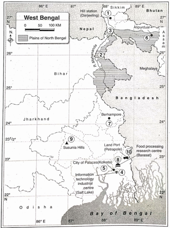
Answer:
Terai Region Of West Bengal Also Known As The ‘Dooars’ Or ‘Duars’:-
The word ‘Terai’ means low marshy ground. The sloping foothills in the southern part of the Himalayan range in North Bengal have an abundance of pebbles, wetlands, and dense forests. Thus, this region has a wet and
damp environment and is called the ‘Terai’ region. On the other hand, the Terai region also serves as the gateway to Bhutan, i.e., the door to Bhutan is the Terai. region. For this reason, the Terai region is also called the ‘Dooars’ or ‘Duars’.
There are 23 districts in West Bengal that are grouped into 5 administrative divisions—The word ‘Tal’ means lowland or lake. The intermediate region between Mahananda and Kalindi rivers in Malda, the whole of Cooch Behar, some areas to the south of Jalpaiguri, and some areas to the north of Uttar Dinajpur are low-lying plains, which are termed as ‘Tal’. In these low-lying plains, the rivers such as Mahananda, Kalindi, Jaldhaka, Torsa, etc. flow very slowly, often changing their courses and the riverbeds of these rivers are quite shallow. Thus, these rivers overflow their banks during the heavy showers in the monsoon season. For this reason, the plains of North Bengal are extremely flood-prone.
There are 23 districts in West Bengal which are grouped into 5 administrative divisions—The western plateau region of West Bengal is rich in mineral resources. Fluge amounts of coal, fire clay; moderate quantities of china clay, dolomite, limestone, quartz, apatite, manganese graphite, etc., and a small amount of iron ore are found in this region. This plateau is ancient and is an extension of the Chota Nagpur Plateau. Thus, the western plateau region of West Bengal has an abundance of different types of general resources.
Question 4 ‘The Gangetic delta region has a high density of population/ Explain.
Answer:
The Gangetic delta region is one of the world’s most densely populated regions.
The causes of the such high density of population are discussed below—
1. Plain relief: The plain relief is ideal for agriculture as well as transport and communication.
2. Moderate climate: The moderate climate and adequate rainfall are the causes of the high density of the population in this region.
3. Fertile alluvial soil: The soil of the deltaic region is made up of alluvial soil (silt) which is very fertile and suitable for agriculture.
4. Development of transport: The area is covered by an extensive network of railways, and roadways.
5. Job opportunities: This region is well-developed in both agriculture and industry and so job opportunities are plenty here.
Question 5 Differentiate between the physiography of the northern hilly region and the western plateau region.
Answer:
Physiography Of The Northern Hilly Region And The Western Plateau Region:-
The northern hilly region of West Bengal includes the districts of Darjeeling, Kalimpong, and Alipurduar. On the other hand, the entire districts of Purulia, Jhargram, Paschim Medinipur, Paschim Bardhaman, Bankura, and the western part of Birbhum fall under the western plateau region.
The differences between the physiography of the northern hilly region and the western plateau region of West Bengal are as follows—
| point of difference | Physiography of northern hilly region | Physiography of the western plateau region |
| 1. Age | This landform is comparatively new. | This landform is comparatively ancient. |
| 2. Origin | The Indian subcontinent plate converges with the Siberian plate due to tectonic movement. The northern hilly region has formed at this convergent boundary. | Ancient highlands have been eroded gradually for a Dong period of time by exogenic forces which have resulted in the formation of this plateau region of low elevation. |
| 3. Characteristic features | High peaks, canyons, and steep slopes are the main characteristic features of this region. | Undulating highlands, erosional plateaus, and isolated hills of low elevation are the characteristic features of this region. |
| 3. Slope | It slopes from north to south. | It slopes from west to east and southeast. |
Question 1 Why West Bengal is known as a riverine or riparian state?
Answer:
West Bengal Is Known As A Riverine Or Riparian State:-
West Bengal is a riverine or riparian state with many rivers, tributaries, distributaries, etc. They all have formed a drainage network. The sources of these rivers are the Himalayan Range and the western plateau or Chota Nagpur Plateau. These rivers drain into the Bay of Bengal. In addition to this, there are several tide-fed rivers in the Sunderban region. On one hand, all these rivers flowing across the state have made the plains of the state fertile one by their silt deposition, on the other hand, the water from these rivers is used for household, agricultural, industrial, and various other purposes. Hence, it will not be wrong to call West Bengal a gift of the Ganga, Bhagirathi, and their tributaries and distributaries. Thus, it is called a riverine or a riparian state.
Question 2 What are the characteristics of a river of North Bengal?
Answer:
Characteristics Of A River Of North Bengal:-
Teesta,
Torsa,
Dhaka,
Mahananda,
Sankosh,
Raidak, etc are notable rivers of North Bengal.
Characteristics of these rivers are as follows—
1. Snowfed rivers: Most of the rivers are snow-fed but some rivers have originated from springs.
2. Follow the slope of land: Rivers flow towards the south and southeast according to the slope of the land.
3. Entry into Bangladesh: Most of the rivers of this region ultimately enter Bangladesh and join the river Jamuna (Brahmaputra). Though some of the rivers also meet the river
Padma.
4. Perenniality: Being snowed, the rivers carry water throughout the year and are thus perennial rivers.
5. Presence of strong currents: The rivers flow rapidly in mountainous regions and have strong currents. So they form narrow V-shaped alleys known as gorges in their course and these strong water currents are tapped for hydroelectric power generation.
6. Proneness to flood: The rivers are prone to flooding as they enter the plains from the mountainous regions.
Question 3 State the characteristics of rivers of the plateau area of West Bengal.
Answer:
The characteristics of the river of the plateau area of West Bengal are:
1. The rivers are the tributaries of the Bhagirathi-Hooghly river.
2. The rivers originate from the Chota Nagpur Plateau region.
3. The rivers are rainfed and so they remain dry except during the rainy season.
4. The rivers flow from west to east or southeast.
Question 4 Give an account of the rivers of the Rarh Plain and the Gangetic Delta.
Answer:
Rivers of the Rarh Plain: Most of the rivers in this region have their sources in the Chota Nagpur Plateau and they either flow to the east or southeast from the west, following the slope of the land. For example, the Damodar river originates from the Khamarpat Hills of the Palamau district of Jharkhand and meets the Bhagirathi-Hooghly to its east. A branch of river Damodar, known as Mundeswari meets the Rupnarayan river. The combined flow of the Dwarakeswar and Shilabati rivers, after flowing towards the southeast, is known as Rupnarayan which meets the Hooghly river. Other notable rivers of this region include Kangsabati, Ajoy, Bakreswar, Mayurakshi, Dwaraka, etc.
Rivers of Gangetic Delta: The major river of this delta region is the Bhagirathi-Hooghly and its important tributaries are Ichamati, Churni, Jalangi, etc. These rivers flow from north to south over the deltaic plains. Besides, many rivers of the Sunderbans are fed by tidal waters, such as Raimangal, Malta, Gosaba, Bidyadhari, etc.
Question 5 Why are most of the rivers of the plateau region in West Bengal east flowing?
Answer:
Notable rivers of the western plateau of West Bengal are Ajoy, Mayurakshi, Damodar, Rupnarayan, Brahmani, Kopai, Dwarakeswar, Shilabati, etc. Most of the rivers have originated from the Chota Nagpur Plateau in the west and then they flow from west to east in the western plateau region according to the slope of the land.
Most of the rivers meet the river Bhagirathi- Hooghly at different places. The general slope of the western plateau is from west to east. Hence, most of the rivers flow in this direction. These rivers are mainly rainfed in nature. Thus, in the rainy season, most of the rivers cause floods in the adjacent areas due to excessive rainfall.
Question 6 ‘The rivers of the western plateau region of West Bengal dry up during the dry season.’Why?
Answer:
The famous rivers of the western plateau region are the Damodar, Ajoy, Mayurakshi, Kangsabati, etc. The rivers dry up in the dry season because—
1. Rainfed river: Most of the rovers of the plateau area are fed rainwater, so it has water only during the rainy season.
2. High temperature: The temperature of the summer season is about 40°C and hence the rate of evaporation is also very high during this time which leads to the drying up of water bodies.
3. Impact of dams: Various dams and reservoirs have been built in this area, which store the water and also regulates the water flow in rivers. Thus, in the lower courses of the river, the amount of water gets reduced as a result of this.
Question 7 Why was river Damodar called the ‘Sorrow of Bengal’?
Answer:
Damodar Called The ‘Sorrow Of Bengal’:-
Damodar is the main river of the western plateau and the Rarh region. The Damodar river rises in the Khamarpat Hills of the Palamau district of Jharkhand. It flows for a distance of 541km through the states of Jharkhand and West Bengal. The river has several tributaries, such as Barakar, Konar, etc in its upper course, i.e., in the Chota Nagpur Plateau region. Excessive rainfall in the upper course of the river during monsoon raises the water level in its lower course in West Bengal and floods the adjacent areas.
This used to be a yearly phenomenon in the lower course of the river affecting the districts of Bardhaman, Bankura, Howrah, Hooghly, etc. A huge loss of life and property was the outcome of these floods, especially for the people residing along the banks of the river. This is why river Damodar was called the ‘Sorrow of Bengal’. However, the Damodar Valley Multipurpose Project has hugely helped to regulate the floods.
Question 8 Why Kangsabati is called the ‘Sorrow of Medinipur’?
Answer:
Kangsabati Is Called The ‘Sorrow Of Medinipur’:-
River Kangsabati has its source in the Ajodhya Hills of Purulia and flows through the Bankura, Paschim Medinipur, and Purba Medinipur districts. It meets river Haldi and drains into the Bay of Bengal. Due to a steep gradient in the upper course, the river water does not remain stagnated and flows according to the slope. But the gradient is very low in the lower course i.e., in the Purba Medinipur district, and thus flooding occurs as a result of heavy rainfall in the upper course. Since these floods result in massive destruction of life and property here, Kangsabati is called the ‘Sorrow of Medinipur’.
Question 9 why are ‘khanris’ creeks found in the Sunderban region of West Bengal?
Answer:
The mouth of wide rivers is usually known as ‘khanris’ or creeks. The numerous small channel-like waterbodies in the interior of the Sunderbans are known as ‘khanris’. The sea water enters through these channels into the interiors of Sunderbans as an action of regular tides. The same water again recedes during ebb. This regular advancement and recession of water have led to the formation of permanent channel—like waterbodies of short length called ‘khanris’. The ones that have a longer length are called rivers. E. g., Saptamukhi, Jhilli, etc. The regular tidal action through the mouths of these khanris has led to the widening of the mouths and the gradual narrowing down of these channels towards the interior of the land.
Question 10 Discuss the utilization of waterbodies, rivers, canals, wells, etc.
Answer:
Waterbodies are very important to mankind. The various utilization of waterbodies rivers, canals, wells, etc. are as follows-
1. Agricultural purpose: The state of West Bengal is agriculture oriented. Irrigational practices depend mainly on rivers, canals, etc.
2. Transportation purpose: The river Bhagirathi-Hooghly is an important component of West Bengal’s transportation system.
3. Drinking water and other household purpose: The purified water is utilized for drinking purposes. Other household chores such as cleaning, washing, and cooking also involve the use of water.
4. Industrial purpose: Water from rivers, canals, etc., contribute mostly to the development of the industrial sector and the process of manufacturing in factories. For example, many industries have developed on the banks of the river Hooghly.
5. Plantation: Water is used in social afforestation and agricultural afforestation. Huge amounts of water are used for planting trees in the western plateau region.
6. Generation of electricity: The production of hydroelectric power is done from river dams.
For example, from the waters of Mython, Panchet, and Tilaiya dams on the river Damodar, hydroelectricity is produced.
Question 11 Delineate the multivarious uses of groundwater in West Bengal.
Answer:
The multivarious uses of groundwater in West Bengal are as follows—
1. Agriculture: Groundwater is used in areas where there are no rivers or other water bodies for irrigation.
2. Drinking water: Groundwater is mainly used for drinking purposes.
3. Domestic purpose: Domestic or household works like cooking, washing clothes, cleaning rooms, etc., are done using groundwater.
Question 12 Discuss the disadvantages of excessive utilization of surface water in West Bengal.
Answer:
The disadvantages of excessive utilization of surface water in West Bengal are as follows—
1. Dwindling the number of waterbodies and water scarcity: Excessive use of surface water for several household chores leads to a decrease in the amount of water in the waterbodies and drying up of the existing ones in the dry seasons.
2. Water resources being affected: Excessive use of surface water affects aquatic resources and also disturbs the aquatic ecosystem.
3. Livelihoods affected: People dependent on fisheries and related livelihoods are often affected if the waterbodies dry up or if the aquatic resources are hampered due to excessive use of surface water.
4. Rise in water pollution: Excessive people being dependent on dwindling waterbodies results in aggravated water pollution.
5. Depletion in the groundwater reserve: Excessive use of surface water hampers the recharge of groundwater through seepage. Thus, the level of groundwater decreases and gets polluted as well.
Question 13 What are the disadvantages of excessive use of groundwater?
Answer:
The disadvantages of excessive use of groundwater are as follows—
1. Arsenic contamination: The excessive use of groundwater results in the deposition of fluoride in groundwater and it causes diseases like black foot and cancer. In West Bengal, Nadia, Murshidabad, Uttar, Dakshin Dinajpur, Bardhaman, and Howrah, Hooghly districts are affected by arsenic pollution.
2. Increase of salinity: There is a presence of different types of salt from the rock layers mixed with groundwater. The excessive use of groundwater increases the salinity of the soil. The districts of Nadia and Bardhaman face this problem and there is a scarcity of drinking water over here as a result.
3. Subsidence of land: Excessive withdrawal of underground water leads to the subsidence of land. Kolkata and its adjacent areas are vulnerable to land subsidence in the future due to the excessive withdrawal of groundwater.
4. Depletion in the groundwater level: Unregulated withdrawal 0f groundwater has led to a fall in the groundwater level in most regions of West Bengal.
Question 14 Why is the groundwater level of the western plateau region not high?
Answer:
The groundwater level of Purulia, Bankura ‘ Paschim Medinipur, Birbhum, Jhargraim Paschim Bardhaman i.e.,
The western plateau region is not high because—
1. The rainfall is very low in the plateau area, so the level of groundwater remains low.
2. The slope of the area is from west to east, so it does not allow the water to stand and infiltrate below.
3. The land is made of hard rocks which prevent water infiltration into the lower layers.
Question 15 Why man is responsible for the reduction of the amount of groundwater?
Answer:
The storage of water in permeable rock beds is called groundwater. This groundwater level is decreasing day by day as a result of its withdrawal and exploitation by man for various purposes.
Some of them are—
1. Increased demand for drinking water: Since the population is increasing at a fast pace, the groundwater level is gradually lowering as a result of its uncontrolled withdrawal from wells, tube wells, etc.
2. Urbanisation: Increasing urbanization has led to increased concretization (of roads, pavements, buildings, etc.) and a decrease in open spaces. Hence the rainwater is not able to infiltrate or seep through the rock layers. As a result of this, the groundwater level is depleting day by day.
3. Agriculture: Since cultivation is done throughout the year, even during the dry season (with the help of irrigation—mostly relying on groundwater), the groundwater resources get depleted.
Question 16 Write the differences between rivers of hilly regions and rivers of plateau regions.
Answer:
The differences between rivers of hilly regions and rivers of plateau regions are as follows—
Question 17 What are the differences between the rivers of North Bengal and the rivers of South Bengal?
Answer: The differences between the rivers of North Bengal and the rivers of South Bengal are as follows—
Question 1 Discuss the impact of a season change on human life.
Answer:
The impact of season change is observed not only on the human body and mind but also on the. livelihood and economy of the region.
1. Impact on body and mind: The change of season affects the human body and mind heavily. For example, extremely hot weather brings tiredness and excessive cold temperature causes lethargy.
2. Change in cultivation: Different crops are cultivated in different seasons. For example, vegetables grow well in winter. Winter is also ideal for cultivating ‘Rabi’ crops and the rainy season is for ‘Kharif’ crops.
3. Change in diet: The diet of human beings changes according to the season because people consume seasonal fruits and vegetables available in the market.
4. Change in biological processes: The duration of days and nights vary according to different seasons. Thus, the biological clock of the human body changes accordingly.
5. Impact on festivals and tourism: Durga puja, the main festival of West Bengal, is celebrated in autumn. Picnics, circuses, fairs, etc. are held in winter. All these seasonal activities create employment, that affects human life.
Season change also impacts tourism. For example, hilly regions attract more tourists during winter.
6. Increase of diseases: Several diseases are caused due to season change. For example, colds and coughs during the rainy season chicken pox in spring, etc., are seasonal diseases.
Question 2 What is ‘EI Nino’? What influences does ‘EI Nino’ have on the arrival of monsoon winds in west Bengal?
Answer:
Concept of ‘EI Nino’:
EI Nino’ is a local term meaning ‘Jesus Christ’. The warm current moving towards the south on certain years, in the Pacific Ocean, along eastern Peru, the western part of Ecuador, etc., is called El Nino. Effect of El Nino on the monsoon winds in,
West Bengal: In the years which are affected by El Nino, the southwest monsoon winds become less active, although its direct influence is not fully established. However, a link always exists between the occurrence of the El Nino phenomena and the prevalence of drought, conditions in India. Since the southwest monsoon winds blow over West Bengal, along with the entire Indian subcontinent in general, El Nino influences the climate of West Bengal too. It is commonly seen that El Nino years coincide with drought conditions in West Bengal.
Question 3 Discuss the main climatic factors of West Bengal.
Answer:
The main climatic factors of West Bengal are—
1. Tropic of Cancer: Since the Tropic of Cancer (2334° N) passes through West Bengal, the state (except the mountainous region of Darjeeling) is warm in nature.
2. Monsoon winds: The moisture-laden southwest monsoon winds blow over West Bengal during the rainy season causing widespread rainfall. Again, the dry north-east monsoon winds blow over the state causing no rainfall. These winds are cold since they arrive from mountainous areas. Thus, West Bengal experiences cold weather devoid of rainfall during the winter months.
3. Altitude of the land: There is an inverse relationship between altitude and temperature. With every 1000 meters of ascent, the temperature drops at the rate of 6.4°C, and hence the temperature decreases with an increase in altitude. Since the Himalayan mountain regions are greater in altitude as compared to the plains, they have much lower temperatures.
4. Location of the Bay of Bengal: Since the Bay of Bengal lies to the south of West Bengal, it has a moderate climate with no extreme temperature.
5. Location of the Himalayan mountains: The Himalayas are aligned from west to east across the northern part of the state. On one hand, it is responsible for causing rainfall (relief or orographic rainfall), while on the other, it acts as a barrier and prevents the cold winds (north-east monsoon winds) from blowing over the state during the winter months of hilly region and the climate of the plateau.
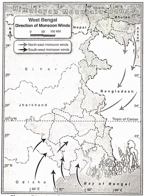
Question 4 Write the differences between the climate of the hilly region and the climate of the coastal region.
Answer:
The differences between the climate of the hilly region and that of the plateau region are as follows –
| Point of difference | The climate of the hilly region | The climate of Platean region |
| 1. Temperature | The average summer temperature is 16*C and the average winter temperature is 4 degrees C-5’C. | The average summer temperature is 40’C and the average winter temperature is 100 ‘C-12’C |
| 2. Rainfall | The annual amount of rainfall in this region is more than 400 cm. | The annual amount of rainfall in this region is between lOOcm-lSO cm. |
| 3. Relative humidity | The relative humidity of this region is high throughout the year. | The relative humidity of this region is low throughout the year, except rainy season. |
| 4. Nature of climate | Wet and cold temperate climate prevails in this region. | A dry and extreme type of climate prevails in this region. |
Question 5 Write the difference between the climate of the hilly region and the climate of the coastal region.
Answer:
The differences between the climate of the hilly region and the climate of the coastal region are as follows—
| Point of difference | The climate of the hilly region | The climate of the coastal region |
| 1. Temperature | The average summer temperature is 16 C and the average winter temperature is 4’C-S’C. | The climate in coastal region’s Average summer temperature is 30C and the average winter temperature is 25C. |
| 2. Rainfall | Annual rainfall is 400 cm in this region. | Annual rainfall is 200 cm in this region |
| 3. Cyclone | In this climate, cyclones generally do not occur. | In this climate, cyclones occur during autumn. |
| 4. Snowfall. | Occasionally snowfall and hailstorms occur in the winter and summer seasons respectively. | Occasionally hailstorm summer season but snowfall never occurs. |
| 5. Fog. | Foggy weather prevails most of the time of the year. | foggy weather prevails only in winter seasons |
Question 1 Classify the agricultural crops that are Produced in west Bengal.
Answer: Agricultural crops that are produced in West Bengal can be classified on a different basis.
They are—
1. On the basis of the season: On the basis of season, the crops of West Bengal can be classified into three types—
1. Kharif crops: Crops like a man (a type of Paddy), jute, sugarcane, etc. that are sown in the rainy season and harvested in winter are called Kharif crops.
2. Rabi crops: Crops like wheat, barley, jowar, gram, potato, etc. that are sown in winter and harvested at the beginning of summer are called rabi crops.
3. Zaid crops: Crops like maize, groundnut, vegetables, and fruits that are sown in spring i.e. month of February-March, and harvested at the beginning of monsoon i.e., the month of June are called Zaid crops.
2. On the basis of use: On the basis of use, the crops of West Bengal can be classified into two types—
1. Food crops: Amongst the agricultural crops rice, wheat, barley, maize, etc. are called food crops, because these crops are cultivated mainly to use as food.
3. Commercial crops: Agricultural crops like tea, jute, etc. are cultivated mainly to sell in the market for profit. These crops are called commercial crops.
They are three types—
1. Plantation crops: Crops that are cultivated in a large garden or estate with the help of modern technology, mainly for export are called plantation crops. Examples—are tea, coffee, rubber, etc.
2. Fibre crops: Crops that are cultivated for the production of fiber or thread are called fiber crops. Examples—are cotton, jute, mesta, etc.
3. Horticulture: Horticulture is the cultivation of fruits, flowers, and vegetables with the help of modern technology.
Question 2 What is the importance of irrigation in West Bengal?
Answer: Irrigation is one of the key components for agricultural development in West Bengal, because—
1. To reduce the uncertainty of monsoon: In West, Bengal rainfall is dependent mainly on the southwest monsoon. This wind is uncertain thus causing flood or drought. Therefore, irrigation is important to reduce the uncertainty of agriculture in West Bengal.
2. For cultivation of rabi crops: Winter is almost dry in West Bengal. At this time irrigation is needed for the cultivation of rabi crops.
3. For cultivation of a high-yielding variety of crops: To fulfill the need for food for the growing population of West Bengal, cultivation of a high-yielding variety of crops is necessary. For this adequate amount of water is required throughout the year. That is why irrigation is important in West Bengal to maintain the water supply.
4. To reduce spatial variation of water holding capacity of soil: Different types of soil are found in different districts of West Bengal. Each of the soil has a different texture, which affects its water-holding capacity. Coarse-textured soil has a poor water-retaining capacity, that needs proper irrigation for cultivation.
5. For water supply in dry region: The Western Plateau region of West Bengal receives less amount of rainfall. That is why irrigation is important in this region of West Bengal for cultivation throughout the year.
Question 3 ‘The plain region of West Bengal is ideal for paddy and jute cultivation/— Explain.
Answer: In the plain region of West Bengal comprising Uttar and Dakshin Dinajpur, Malda, Murshidabad, Nadia, Purba, Bardhaman, Hooghly, North and South 24 Parganas districts, production of jute and paddy are quite high.
Because—
1. Extensive plain land: Plain and flat land is needed for the cultivation of paddy and jute. Thus, plain areas are better for cultivation than the hilly and plateau regions.
2. Fertile soil: The fertile silty soil is ideal for the cultivation of paddy and jute and this type of soil is found in the plain region (including the Gangetic plain) of West Bengal.
3. Availability of labor: The availability of cheap labor is important for the cultivation of paddy and jute. Since the plains are densely populated, labor is abundant and readily available.
Question 4 ‘Agriculture in the Terai region is not developed’—Explain why.
Answer: The Terai region comprises the subdivisions of Siliguri, Jalpaiguri, and Alipurduar. The area is made up of Unconsolidated sediments. The average altitude of the area ranges from 75 m to 150 m above sea level. Teesta, Torsa, Jaldhaka, Raidak, Sankosh, Mahananda, etc., deposit cobbles, pebbles, and other finer sediments here. So, the region is not suitable for agriculture. On the other hand, the humid conditions are not favorable for cultivation here. However, tobacco and small quantities of paddy, and various types of fruits are cultivated here.
Question 5 ‘Agriculture is well-developed in the Gangetic delta/—Why?
Answer: The Gangetic delta region is famous for agriculture. Most of the people here depend on agriculture for their livelihood. The reasons for the development of agriculture here are-
1. Extensive plain area: The delta region is flat and plain and so it is favorable for agricultural practice as well as irrigation facilities.
2. Fertile silty soil: The area is made up of silty sedimentary soil which is fertile and therefore favorable for agriculture.
3. Appropriate temperature and rainfall: The temperature and rainfall of the tropical area are appropriate. Paddy, jute, and vegetables are cultivated here.
4. High density of population: High density of population provides abundant labor required for agricultural practice. The demand for food is also high in this region. That is the reason why agricultural productivity is high here.
Question 6 What is the importance of agriculture in the economy of West Bengal?’
Answer: The importance of agriculture in the economy of West Bengal is unlimited.
These are as follows—
1. Source of employment: About 70% population of West Bengal is engaged in agriculture. Around 53%-55% of the laborers are engaged in agriculture either directly or indirectly. Agriculture thus provides ample job opportunities to the people of the state.
2. Development of agriculture-oriented industry: Tea, jute, and food processing industries are agro-based industries. These industries are dependent on agriculture for development.
3. Foreign exchange: The two major agricultural crops of West Bengal are—tea and jute. The export of these two crops helps in earning foreign exchange.
4. Prosperity of the fertilizer industry: Various fertilizers are used for the production of crops and this has led to the prosperity of this industry.
Question 7 What are the problems that West Bengal is facing in agriculture?
Answer:
Although agriculture in West Bengal has great importance, it is facing several problems—
1. Lack of irrigation: Much of the land could not be brought under irrigation yet and so agricultural productivity in certain areas of West Bengal is hampered.
2. Dependency on monsoon winds: Agriculture of West Bengal is mainly dependent on monsoon winds. Any fluctuation in the wind pattern causes the loss of crops.
3. Limited use of high-quality seeds, fertilizers & pesticides: High-quality seed fertilizers, and pesticides are not used everywhere and hence agricultural productivity is low in West Bengal.
4. Use of primitive methods: Old and primitive agricultural methods like plows, sickles, and animals are still used. Modern implements are not used.
5. Low capital: The capital investment for agriculture is very low.
6. Low market price: The market price of produced crops is very low. Many farmers commit suicide out of frustration.
Question 1 Why is Howrah called the ‘Glasgow of India’?
Answer: The headquarters of the Howrah district is Howrah. Howrah, the second largest city of West Bengal is located opposite Kolkata on the western bank of the Hooghly river. Howrah is an important town in the Hooghly industrial region. The jute industry, engineering industry, cotton, textile, and other industries are developed here. A large number of engineering industries are situated here like the Glasgow city of England, so the city is called the ‘Glasgow of India’
Question 2 Why is Durgapur called the ‘Steel city?
Answer: Durgapur is one of the modern industrial cities in West Bengal. Here the engineering industries are highly developed. The Durgapur Steel Plant (DSP), Alloy Steel Plant (ASP), and Central Mechanical Research Institute are located here. In the steel factory of Durgapur, ‘stainless steel’ is made by mixing chromium and nickel. With the help of the joint venture of Canada and Japan, alloy steel is manufactured here. The variety of steel projects has made Durgapur a ‘Steel City’.
Question 3 Durgapur is called the ‘Ruhr of India’.
Answer: Ruhr is a small tributary river of the river Rhine of Germany. Industries have developed in this area based on coal found in abundance here.
The whole region is called the Ruhr Industrial Region. In West Bengal, coal is found in the Damodar river valley of Paschim Bardhaman district. The iron and steel industry, cement industry, engineering industry, etc. have developed here based on the available storage of coal. That is why Durgapr is called the Ruhr of India
Question 4 Write a short note on IISCO.
Answer: The first iron and steel industry in India was established in Kulti in 1870 and another one was established in Burnpur in 1918. The Indian Iron and Steel Company (IISCO) is the collaboration of these two plants. During the fifth five-year plan another iron and steel plant was established at Durgapur in Paschim Bardhaman district with the help of IISCO. Later it was amalgamated with a government organization named SAIL.
Causes of development: The main causes of the development of IISC are as follows—
1. Availability of coal from Raniganj and Jharia coal mines;
2. Accessibility of iron ore from Noamudi, Gua in Jharkhand and Gorumahisani, Badampahar in Odisha;
3. Available other raw materials such as limestone (Birmitrapur), manganese (Gangpur), and dolomite;
4. Abundance of water from Damodar and Barakar rivers;
5. Availability of power resources from Durgapur and Mejia thermal power plants developed here. A large number of engineering industries are situated here like the Glasgow city of England, so the city is called the ‘Glasgow of India’.
Question 5 Discuss the problems and prospects of the tourism industry in West Bengal.
Answer:
Problems of the tourism industry in West Bengal: The main problems of the tourism industry in West Bengal are—
1. Lack of modern technology: The modern technology that is used by developed countries for the food processing industry is not available in West Bengal.
2. Lack of crop preservation: In West Bengal, the lack of proper crop preservation techniques decreases industrial demand.
3. Prospects of the food processing industry: The food processing industry is gaining importance. Adequate help from the Government, food park, cold storage, plans by the center, awareness regarding preservation, and control of pollution will help the growth of the food processing industry.
Question 1 Discuss the causes of the development of the Haldia port.
Answer: The causes of the development of the Haldia Port are as follows—
1. As support to help the Kolkata port: The importance of Kolkata port has decreased since the navigability of the river
Hooghly has decreased due to siltation. As a result, big ships are not able to enter the port. This is the reason why the port of Haldia has been established at the junction of the Hooghly and Haldi rivers.
2. Easy availability of land: Easy availability of land has facilitated the infrastructural development of the Haldia port.
3. Fulfilling the demand for trade and commerce: The import and export of raw materials and products through Haldia port fulfill the demand for trade and commerce and this helps in the development of this port.
Question 2 Why is Siliguri called ‘North-east India’? Gateway of Northeast India?
Answer: Siliguri is the headquarters of the Darjeeling district. NH 31 and NH 34 pass through this town. These national highways are connected with Bihar, West Bengal, Assam, Arunachal Pradesh, Nagaland, Manipur, Mizoram and
Tripura. The eastern railway, north-eastern railway, and Bagdogra airport are located here, which connect Kolkata, Patna, and Guwahati. This is why Siliguri is known Gateway of Northeast India.
Question 3 What are the bases of origin of cities in West Bengal?
Answer: West Bengal has the second highest population density (1028 persons per sq. km) in India, after Bihar. The bases of the origin of cities in
West Bengal is as follows—
1. Educational and cultural center: Proper educational and recreational facilities enhance the growth of a city. People are also attracted to the cultural center of a region, which helps to develop a city. Example—Shantiniketan.
2. Tourist center: A famous tourist spot always attracts people from different places. It helps to grow restaurants, lodges and other business opportunities that lead to the origin of a city. Example— Darjeeling.
3. Commercial center: A commercial center always tends to grow business and supports employment, which helps to develop a city. Example—Haldia.
4. Industrial center: An industrial center always tends to increase productivity which increases employment facilities and leads to population growth. As a result, a city develops. Example—Asansol.
5. Mining center: Cities may also develop around mines, because of employment opportunities and other socio-economic facilities. Example—Raniganj city around a coal mine.
Question 4 Write about a tourist spot in West Bengal.
Answer: A brief description of a tourist spot in West Bengal is given below—
1. Location: An important tourist spot in West Bengal is Darjeeling. It is a famous hill station located in the eastern Himalayas.
2. Communication: Darjeeling hill station can be reached from Siliguri through the roadways or by the toy train.
3. Climate: Due to the high altitude, the weather of this place is very pleasant in summer, and snowfall may occur in winter. Spring and summer are the ideal time to visit Darjeeling.
4. Places of attraction:
1. Tiger hill is famous for the stunning view of sunrise and Kanchanjunga peak.
2. Mall is the heart of Darjeeling.
3. Himalayan Mountaineering Institute is an important place for mountaineers.
4 Adjacent areas of Darjeeling like, Mirik, Kurseong, etc. are also famous places to visit. On the way up the hill from the plain, the beauty of the forest is mesmerizing.
Question 5 The importance of the Kolkata port is declining gradually. why?
Answer: Kolkata was considered one of the best ports in India. However, its importance is declining due to the following reasons—
1. Decrease in navigability of the Bhagirathi-Hooghly river: The regular deposition of sediment (silt and sand) has
decreased the navigability of the BhagirathiHooghly river. Thus, the entry of big ships is becoming difficult in Kolkata port.
2. Meandering nature of Hooghly river: Numerous big and small meanders exist on the Hooghly river (from its mouth to Kolkata port). This causes difficulties for the ships to enter.
3. Other causes: Since other ports like Paradip, Visakhapatnam, Haldia, etc., have been established, the hinterland of Kolkata port has decreased. Moreover, excessive taxes, labor dissatisfaction, etc., are also diminishing the importance of the Kolkata port.
Question 6 ‘The underdeveloped Sundarbans region/called aExplain.backward or underdeveloped region.’Explain.
Answer: The Sundarbans are called a backward or underdeveloped region because of the following reasons—
1. Agricultural problem: The area is comprised of saline soil. Besides, outdated and traditional methods of cultivation are
prevalent here which are not favorable for agricultural development.
2. Lack of mineral resources: Mineral resources have not been found in this region. Thus industries based on these minerals have not developed here.
3. Underdeveloped transport: The area is riverine in nature and so roadway and railway facilities are not developed here properly. Boats and steamers are the main modes of transport in this region.
4. Lack of electricity: Many small islands here are devoid of electricity. Thus, even small industries have not developed here.
5. Natural hazards: Oceanic cyclones, tsunamis, floods, breaking of dams, etc., are the main problems of this region. They cause much loss of life and property in this region.
Question 7 ‘The Sundarban area has a low population/ Why?
Answer:
The Sundarban area has a low population because—
1. The agricultural land available is very small.
2. The soil is saline and so agricultural production is low.
3. Irrigation facility is poor in this region.
4. Transport and communication are outdated and underdeveloped.
5. There is no industry in this area.
6. Frequent occurrence of natural hazards like cyclones, and floods.
7. Presence of insects, snakes, and wild animals tigers are the main causes wild of the low population in this system is
Question 8 Kolkata and Howarah are called ‘Twin Cities’ Explain.
Answer: The two main and significant cities of West Bengal are Kolkata and Howrah. These cities are located on either bank of the river Hooghly. Kolkata is located on the eastern bank and is the capital of West Bengal, while Howrah which is the main industrial city of West Bengal lies on the western bank of the Hooghly river. These two cities are connected by two bridges that have been built over the river Hooghly— the Hpwrah Bridge or Rabindra Setu and Second Hooghly Bridge or Vidyasagar Setu. Kolkata is the center of trade and commerce, politics, and culture. On the other hand, Howrah is known as the ‘Glasgow of India’ and stands out as an important industrial center. These two cities are dependent on each other and this is the reason why they are called ‘Twin Cities’.
Chapter 8 West Bengal Short Answer Type Questions
Question 1 How many seasons are observed in West Bengal?
Answer:
Seasons Observed In West Bengal:-
There are 4 seasons in West Bengal. They are summer, monsoon, autumn, and winter.
Question 2 What do you mean by western disturbance?
Answer:
Western Disturbance:-
During winter, cyclonic storms originating in the Mediterranean region, cause low pressure and sudden winter rain in northwest India. Such a weather phenomenon is called a western disturbance.
Question 3 What is ‘Ashwiner Jhar’?
Answer:
Ashwiner Jhar:-
Generally, West Bengal does not experience rainfall during autumn. But sometimes the cyclones formed in the Bay of Bengal during autumn cause thunderstorms. This is known as ‘Ashwiner Jhar’.
Question 4 What is’Kalbaisakhi’?
Answer:
Kalbaisakhi:-
During the early summer months, West Bengal and its adjoining areas are affected by thunderstorms and even hail storms, especially in the late afternoons. These storm winds blow from the northwest direction and thus are known as ‘Norwester’ or ‘Kalbaisakhi’.
Question 5 Where does snowfall occur in West Bengal?
Answer: The northern part of West Bengal, i.e., the Himalayan mountainous region experiences snowfall due to higher altitude, as the temperature decreases to below freezing point.
Question 1 What were the earlier administrative divisions of West Bengal?
Answer:
The three earlier administrative divisions of West Bengal were—
1. Presidency division,
2. Bardhaman division,
3. Jalpaiguri division.
Question 2 Write about the subdivision and block administration of West Bengal.
Answer:
Subdivision And Block Administration Of West Bengal:-
West Bengal is divided into 23 districts for conducting administrative activities properly. Each district is divided into a number of sub-divisions. A Sub-Divisional Officer (SDO) is in charge of each subs division. Further, each sub-division is divided into a number of blocks. The head of the block administration is called Block Development Officer (BDO). BDO works under the supervision of SDO.
Question 3 What are the administrative divisions of West Bengal?
Answer:
West Bengal is divided into five administrative divisions namely—
1. Jalpaiguri division,
2. Malda division,
3. Burdwan division,
4. Medinipur division and
5. Presidency division.
Question 1 What are the main physiographic divisions of West Bengal?
Answer:
The main physiographic divisions of West Bengal are—
1. Northern hilly region,
2. western plateau region and
3. plain region.
Question 2 What is Mahananda Corridor?
Answer:
Mahananda Corridor:-
The southern part of Jalpaiguri district, the southern part of Cooch Behar district, Uttar and Dakshin Dinajpur districts, and Malda district together form the plain region. North Bengal. The narrow river valley of the Mahananda river which flows from north to south connects the plains of Jalpaiguri and Cooch Behar in the north with the plains of Malda in the south. This narrow valley is called the Mahananda corridor.
Question 3 What is Tal?
Answer:
Tal:-
In the southern part of Cooch Behar and Jalpaiguri districts and the western part of Malda district there are scattered marshes and lowlands which are flood-prone regions. These are locally called ‘Tals’ as the word ‘Taly means lowland or lake.
Question 4 What is Bhabar?
Answer:
Bhabar:-
The sand, silt, and pebbles brought down by the rivers from the Himalayan mountains get deposited in the foothills, giving it a gentle slope. Such a feature is known as the Terai in North Bengal. The rocky land of the Terai region which is covered by forests is known as Bhabar.
Question 5 What is Barendrabhumi?
Answer:
Barendrabhumi:-
In the eastern part of Malda and South Dinajpur, the gently undulating highland formed of laterite soil and old alluvial soil is known as ‘Barendrabhumi’.
Question 6 What is Diara?
Answer:
Diara:-
The region in the southern part of Malda district, along the banks of the river Ganga which is made up of new alluvial soil and is very fertile, is called Diara.
Question 7 What is Bagri?
Answer:
Bagri:-
The region of the Gangetic delta plain which includes the eastern part of Murshidabad and the entire Nadia and North 24 Parganas districts, where the Bhagirathi river and its distributaries do not deposit any silt, i.e., the formation of the delta has almost stopped is known as Bagri. This region is also an inactive delta region.
Question 8 Where is the Rarh plain located?
Answer:
Location Of Rarh plain:-
The intermediate area between the plateau region in the west and Bhagirathi-Hooghly in the east is called the Rarh plain. This region includes the eastern part of Bankura, the western part of Murshidabad, the eastern part of Paschim Bardhaman, the northern and eastern part of Birbhum, and the entire districts of Purba Bardhaman, Purba Medinipur, Howrah, and Hooghly.
Question 9 Where is the active delta of West Bengal found?
Answer:
Active Delta Of West Bengal:-
The active delta of West Bengal is usually found in the southern and eastern parts of South 24 Parganas (i.e., the Sundarbans) and the southern part of North 24 Parganas. In this region, the process of delta formation is still going on.
Chapter 8 West Bengal fill in the blanks with suitable words
1. West Bengal was founded on 15 August 1947
2. Siliguri is known as the of India.North-east gateway
3. Darjeeling district is the ‘Crown of West Bengal’.
4. Burdwan division of West Bengal has 4 districts.
5. From north to south West Bengal extend for about 650 km.
Chapter 8 West Bengal If the statement is true, write True if false, write false against the following
1. Bangladesh lies to the west of West Bengal. False
2. The highest peak in the Darjeeling district is Gorgaburu. False
3. Haryana is a neighboring state of West Bengal. False
4. The Jalpaiguri division of West Bengal has five districts. True
5. In the northern part, Bihar is one of the most important neighboring states of West Bengal. False
6. West Bengal has 19 districts at present. False
7. The second largest neighboring country of West Bengal is Bangladesh. False
8. Ayodhya hill is located in Purulia. True
9. Kathmandu, the capital of Nepal, is an important tourist place. True
Chapter 8 West Bengal Match The Left Column With The Right Column
| Left column | Right column |
| 1. The newest district of west Bengal | A. Tropic of cancer (231/2N) |
| 2. major latitude that passes through west Bengal | B. Jharkhand |
| 3. Neighbouring state of west Bengal | C. Kolkata |
| 4. Capital of West Bengal | D. Paschim bardhaman |
Answer: 1-D,2-A,3-B,4-C
Chapter 8 West Bengal Answer in one or two words
Question 1 What is the total area of West Bengal?
Answer: 88752 sq. km.
Question 2 Which are the newly formed districts of West Bengal?
Answer: Purba Bardhaman and Paschim Bardhaman (7 April 2017).
Question 3 Which district in West Bengal occupies the largest area?
Answer: South 24 Parganas.
Question 4 How many districts do West Bengal have?
Answer: 23 districts.
Question 5 What is the percentage of West Bengal’s area with respect to that of India?
Answer: 2.69%.
Question 6 In which year was Alipurduar formed?
Answer: 2014.
Question 7 What is the capital of Jharkhand?
Answer: Ranchi.
Question 8 What is the capital of Assam?
Answer: Dispur.
Question 9 In which year was Medinipur classified into two administrative divisions?
Answer: January 1, 2002.
Question 10 Krishnanagar lies in which district?
Answer: Nadia.
Question 11 Which district in West Bengal is called the ‘Queen of hill stations’?
Answer: Darjeeling.
Question 12 What is the name of the newest district in West Bengal?
Answer: West Bardhaman (2017).
Question 13 Which administrative division of West Bengal does the Kolkata district belong to?
Answer: Presidency division.
Chapter 8 West Bengal Topic B Physiography Long Answer Type Questions
Chapter 8 West Bengal Short Explanatory Answer Type Questions
Chapter 8 West Bengal Short Answer Type Questions
Chapter 8 West Bengal Fill In The Blanks With Suitable Words
1. The Singalila mountain divides Nepal from Darjeeling.
2. The highest peak of Ajodhya hill is Gorgaburu
3. The word’Terai’means marshy land
4. The word ‘Rarh’ means dry rocky Hand in Santhali.
5. The mountain range lies in the Himalayas north of West Bengal.
6. Barendrabhumi is an old plain.
7. The highest peak of the western plateau region in West Bengal is Gorgaburu.
8. Southern part of the Bhagirathi river is known as Hooghly
Chapter 8 West Bengal If the statement is true, write True if false, write false against the following
1. A mountain pass known as Buxa is situated in the northern mountainous region of the Alipurduar district. True
2. Susunia is the highest bill in the plateau region of West Bengal. false
3. The ancient region of South Dinajpur and Malda districts, composed of alluvial soil is called ‘Barendrabhumi’. True
4. The northern part of the Ganga delta is called the active delta. false
5. The plateau region of West Bengal is [trade of granite and gneiss rocks. True
6.’Terai’ means dry rocky land. false
7. Purulia district of West Bengal falls under the plateau region. True
8. The highest peak of Mama-Bhagne Hills is Gorgaburu. false
9. Ajodhya Hills is located in the Purulia district. True
10. Mama-Baghne Hills are located in the Bankura district. false
11. Purbasha is the largest island of West Bengal. false
12. Sabargram is the highest peak of the Durpin Dara range. false
Chapter 8 West Bengal Match the left column with the right column
1.
| Left Column | Right Column |
| 1. Singalila | A. Gorgaburu |
| 2. Ajodhya Hills | B. Rishi |
| 3. Darjeeling Himalayas | C. Sandakhphu |
| 4. Darjeeling Kurseong Range | D. Tiger Hill |
Answer: 1-C,2-A,3-B,4-D
2.
| Left Column | Right Column |
| 1. Ajodhya Hills | A. Bankura |
| 2. Susumu Hills | B. Jhargram |
| 3. Belpahari | C. Birbhum |
| 4. Mama Bhagne Hills | D. Purulia |
Answer: 1-D,2-A,3-B,4-C
Chapter 8 West Bengal Answer in one or two words
Question 1 Which is the highest peak of West Bengali
Answer: Sandakhphu (3665 m).
Question 2 What is the meaning of ‘Dooars’?
Answer: Door.
Question 3 On which side of the Teesta river does the Terai plain lie?
Answer: Western side.
Question 4 In which part of West Bengal is the Himalayas located?
Answer: Northern side.
Question 5 What is the meaning of ‘Tal’?
Answer: Lake.
Question 6 In which district are the Panchet hills Located?
Answer: Purulia.
Question 7 In which district are the Susunia hills located?
Answer: Bankura.
Chapter 8 West Bengal Topic C River And Water Resources Long Answer Type Questions
Chapter 8 West Bengal Short Explanatory Answer Type Questions
Chapter 8 West Bengal Short Answer Type Questions
Question 1 what is groundwater?
Answer:
Groundwater:-
Groundwater refers to water present underground. When rainwater seeps through the soil layers and gets accumulated under the ground in the permeable rock layers, it is called groundwater.
Question 2 What are the sources of irrigation in West Bengal?
Answer:
Sources Of Irrigation In West Bengal:-
Irrigation in West Bengal is carried out through wells, tube wells, and canals.
Question 3 Why does the river water of Teesta often pose a threat?
Answer:
River Water Of Teesta Often Pose A Threat:-
Teesta is the main river of North Bengal. It is extremely swift-flowing in this mountainous area, but when it enters the plains, the river velocity decreases. This river gets flooded when it is in a spate during the monsoons. The river overflows its banks and floods its adjacent plain lands to a great extent thereby causing much loss to the life and property of the people. This is the reason why the Teesta often poses a threat.
Question 4 Why is the river Bhagirathi-Hooghly called the ‘Lifeline of West Bengal’?
Answer:
River Bhagirathi-Hooghly Called The ‘Lifeline Of West Bengal’:-
The Bhagirathi-Hooghly river is the most significant river in West Bengal. Many tributaries join this river on both banks. This has resulted in the formation of a great plain and delta in the southern part of West Bengal. The plain formed is ideal. cultivation of crops. River Hooghly has an important role to play in supplying water to the industries located on either bank, supplying drinking and domestic water to the towns and cities, supplying water for irrigation to the agricultural fields, and even acting as waterways (river transport). This is the reason why it is called the ‘Lifeline of West Bengal’.
Question 5 Mention two harmful effects of over-exploitation of groundwater.
Answer: Over-exploitation of groundwater has many harmful effects.
Two of its effects are as follows—
1. continuous lowering of groundwater level (both pre-monsoon and post-monsoon),
2. arsenic contamination in groundwater.
Chapter 8 West Bengal Fill in the blanks with suitable words
1. Rasulpur river flows through the KanthiDigha coastal area.
2. A distributary of the Ganga river which enters Bangladesh is Padma
3. Hot springs are found in Bakreshwar in birbhum district of West Bengal.
4. Rivers of North Bengal are snow-fed
5. The northern rivers, being swift flowing, Hydroelectric power generation.
6. Damodar river is called the ‘sorrow of West Bengal’.
7. Teesta river causes destructive
8. Damodar river drains into the Hooghly
9. The rivers of the plateau region are rainfed
10. A right bank tributary of the Teesta river is ranged
13. The Teesta river originates from the jump glacier of Sikkim.
14. A hot spring is located in the Bakreshwar district.
15. Among the rivers of the western plateau region SubarnarekhaS river joins the Bay of Bengal.
16. Damodar river originates from the Khamarpat hills of the Chota Nagpur Plateau.
17. Mayurakshi river originates from the strikeout hills of the Chotanagpur plateau.
Chapter 8 West Bengal If The Statement Is True Write’true And If False Write False Against The Following
1. Teesta is a rainfed river of West Bengal. False
2. The origin of the Damodar river is the Jemu glacier in the Eastern Himalayas. False
3. The rivers of the Sundarbans are swift-flowing. False
4. The local name of Kangsabati is ‘Kansai’. True
5. Rivulets known as ‘khanris’ are noticed along with the rivers of the Sundarban region. True
6. Hooghly is a tributary of Kangsabati. False
7. West Bengal is called the ‘Land of Rivers’. False
8. Brahmani river is called the ‘Sorrow of Medinipur’. True
9. Water that is released from the Damodar Canal causes floods in the Rarh region. False
10. Haldi river flows through the Paschim Medinipur district. True
11. An irrigation canal of West Bengal is Kangsabati Dam. True
12. The origin of the Jaldhaka river is Big Lake. True
Chapter 8 West Bengal Match the left column with the right column
1.
| Left column | Right column |
| 1. River of the north | A. Malta |
| 2. River of the plateau region | B.Teesta |
| 3. River of the plain | C. Ajoy |
| 4. River of sundarbans | D. Ichamati |
Answer: 1-B,2-C,3-D,4-A
Chapter 8 West Bengal Answer In One Or Two Words
Question 1 Name two snow-fed rivers of West Bengal.
Answer: Teesta, Mahananda.
Question 2 Which is the longest river in North Bengal?
Answer: Mahananda.
Question 3 What is the combined flow of the Dwarkeshwar and Shilai rivers called?
Answer: Rupnarayan.
Question 4 What is the combined flow of the Kangsabati and Keleghai called?
Answer: Haldi.
Question 5 The Sevoke bridge spans across which river?
Answer: River Teesta.
Question 6 Name a river that flows over the western plateau area.
Answer: Damodar.
Question 7 Name a tributary of the Teesta river.
Answer: Rangpo.
Question 8 Name two rivers of the Sundarbans.
Answer: Malta and Bidyadhari.
Question 9 Name two tributaries of the Damodar river.
Answer: Konar and Barakar.
Question 10 Name two tributaries of the Bhagirathi.
Answer: Mayurakshi and Ajoy.
Question 11 Name a distributary of Damodar.
Answer: Mundeswari.
Question 12 Which river bisects the mountainous area of north Bengal?
Answer: Teesta.
Chapter 8 West Bengal Topic D Climate Long Answer Type Questions
Chapter 8 West Bengal Short Explanatory Answer Type Questions
Chapter 8 West Bengal Short Answer Type Questions
Chapter 8 West Bengal Fill In The Blanks With Suitable Words
1. The ‘Ashwiner Jhar’ storm occurs in West Bengal during autumn
2. The driest district of West Bengal is Purulia.
3. The duration of summer winds blowing from the Bay of Bengal cause rainfall all over West Bengal.
4. Monsoon seasons are mainly observed in West Bengal.
6. The wettest district of West Bengal is four
7. Climate of West Bengal’s season can be seen from December in Tropical monsoon nature.
8. Winter seasons can be seen from December to February in West Bengal.
Chapter 8 West Bengal If The Statement Is True, Write True And If False Write False Against The Following
1. Rainfall in West Bengal occurs due’ to south-west monsoon winds. True
2. Rainy season prevails in West Bengal from June to September. True
3. The driest district of West Bengal is Bankura. False
4. West Bengal experiences a cold temperate type of climate. False
5. The storms that occur during autumn in West Bengal are called the ‘Aswiner Jhar’ storms. False
6. Being at a higher altitude Darjeeling has a moderate type of climate. True
7. Trade wind controls the climate of West Bengal. False
8. Most of the rainfall in West Bengal occurs due to the effect of southwest monsoon winds. False
9. The number of rainfall increases from the Darjeeling mountain region to the river Ganges. True
10. In the Month of July, the wind blows mainly from the south-eastern direction in West Bengal. False
11. Meaning of monsoon is stormy wind. True
12. Meaning of monsoon in a stormy wind. False
Chapter 8 West Bengal Match The Left Column With The Right Column
| Left column | Right column |
| 1. Extremely hot | A. Darjeeling |
| 2. Extremely cold | B.Purulia |
| 3. Extremely dry | C. Buxaduar |
| 4. Extremely humid | D. Asansol |
Answer: 1-D,2-A,3-B,4-C
Chapter 8 West Bengal Answer in one Or Two words
Question 1 Which area in West Bengal receives the maximum rainfall?
Answer: Buxaduar in Alipurduar.
Question 2 Which is the hottest district in West Bengal?
Answer: Bankura.
Question 3 Which wind influences West Bengal’s climate the most?
Answer: Monsoon wind,
Question 4 Which is the most famous animal of falda para National Park?
Answer: One-horned rhinoceros.
Question 5 In West Bengal, when do western disturbances occur?
Answer: Winter.
Question 6 Which two districts in West Bengal have laterite soil?
Answer: Purulia and Jhargram.
Question 7 Name two trees of the Western Plateau region.
Answer: Arjun and should.
Question 8 Name two -trees belonging to the plain region.
Answer: Mango and Jamun.
Question 9 Which district of West Bengal experiences cyclones frequency?
Answer: Purba Medinipur.
Question 10 What are the seasons of West Bengal?
Answer: Summer, monsoon, autumn, and winter.
Chapter 8 Topic E Soil And Natural Vegetation Long Answer Type Questions
Chapter 8 West Bengal Short Explanatory Type Questions
Question 1 Differentiate between the natural vegetation of the northern hilly region and the natural vegetation of the coastal region of West Bengal.
Answer:
Differences between the natural vegetation of the northern hilly region and the coastal region of West Bengal are as follows—
| Point of difference | The natural vegetation of the northern hilly region | The natural vegetation of the coastal region |
| 1. Location | This type of vegetation can be seen in the Darjeeling, Kalimpong, and Alipurduar districts in the northern part of West Bengal. | This type of vegetation can be seen in the deltaic part of North and South 24 Parganas and coastal areas of Paschim Medimpur district in the southern pan of West Bengal. |
| 2. Nature of Vegetation | Evergreen trees like Shishu. Marjan, sal, teak, bamboo, etc grow in the Himalayan foothills upto 1000 m altitude, mu forest of evergreen and deciduous trees like oak, maple, laurel, etc, grow between 1000 m-2500 m altitude, and coniferous trees like pine, fir. deodar, etc cover the mountain slope between 2500 m-<1000 m altitude, and alpine meadows lie above 4000m altitude of this hilly region. | Mangrove vegetation like Sundari, Garan, gewa, hental, etc grow in the active deltaic region of West Bengal This is the largest mangrove forest in India, popularly known as Sundarbans. Trees like eucalyptus and Casuarina (locally called Jha). etc are seen in the sandy region of Purba Mcdmipur. |
| 3. Characteristics | These trees are tall, use of the leaves decreases gradually with height. | These trees are short, they have breathing roots to absorb oxygen from the atmosphere and stilted roots to support the main trunk Site of the leaves is small in most of the trees. |
Question 2 What are the differences between the natural vegetation of the hilly region and the hilly vegetation plateau region of West Bengal?
Answer:
Differences between the natural vegetation of the hilly region and the natural plateau region are as follows—
| Point of difference | The natural vegetation of the hilly region | The natural vegetation of the plateau region |
| 1. Nature | In the hilly region, natural vegetation changes with the change of elevation. Alpine meadows lie above 4000 m altitude, coniferous forests lie between 2500m-4000m altitude, mixed forests of evergreen and deciduous trees grow between 1000m-2500m altitude and hardwood broadleaved evergreen trees lie at the foothills of Himalayas upto 1000 m altitude. | Homogeneity of climate can be seen in the plateau region, which is favorable for the growth of deciduous trees such as mahua, sal, tendu, Irish, Palash, shim, etc. The trees grow in a scattered manner and have a mix of broad and small leaves. |
| 2. Diversity of leaves | The amount of temperature and rainfall decreases gradually from the foothills to higher altitudes. As a result, the trees of the foothills have broad leaves and their size decreases with height. | In this region, trees have both broad and small leaves and they lose their leaves seasonally. |
| 3. Amount and Density | This type of natural vegetation covers 60% of the total vegetation of West Bengal. The density of this forest is high. | In the plateau region, the amount and density of the forest are very low. |
Chapter 8 West Bengal Short Answer Type Questions
Question 1 What type of soil is found in the plains of West Bengal?
Answer: In the plain region of West Bengal, river-borne fertile silt and silty loam soil are found.
Question 2 Where is saline soil found in West Bengal?
Answer: Saline soil is found in the active delta (Sundarban) region of the southern part of West Bengal.
Question 3 State the characteristics of mangrove forests.
Answer: some of the characteristics of mangrove forests are as follows—
1. The trees have stilt roots to hold them firmly on the soil even during tidal surges.
2. Since the trees are often immersed in tidal waters, they have aerial roots or pneumatophores, which help in the process of respiration.
3. The trees carry out viviparous germination.
4. These trees are evergreen in nature.
Question 4 What is gully or khoai erosion?
Answer: Red soil-rich region in and around Shantiniketan in the Birbhum district is prone to continuous rill, gully, sheet, and ravine erosions. Therefore, the elevation of the land is decreasing day by day, which further leads to the formation of various landforms.
Chapter 8 West Bengal Fill In The Blanks
1. Extensive occurrence of sudden trees has led to the etymology of ‘Sundari’.
2. Stilt roots and pneumatophores are found in mangrove forests.
3. Rhododendron is an alpine tree.
4. Saline soil is found in the coastal region of West Bengal.
5. Laterite soil is red in color.
6. Soil is very fertile in the plain region.
Chapter 8 West Bengal If The Statement Is True to Write True And If False Write False Against The Following
1. Laterite soil is found in the Rarh region. True
2. Pneumatophores are found in Sundari trees. True
3. Coastal soil is favorable for coconut cultivation. True
4. The saline soil of Sundarbans is alkaline in nature. True
5. Khoai erosion is seen in the Rarh region. False
6. Podsol soil is found in the Bankura and Purulia districts of West Bengal. True
7. Goran tree is found in the western plateau region of West Bengal. False
8. Natural vegetation of Sundarbans is called mangrove forest. True
9. Laterite soil is ideal for cultivation. False
Chapter 8 West Bengal Match the left column with the right column
1.
| Left Column | Right Column |
| 1. Podsol soil | A. Gangetlc plain |
| 2. Laterite soil | B. Northern hilly region |
| 3. Saline soil | C. Coastal plain |
| 4. Alluvial soil | D. Western plateau region |
Answer: 1-B,2-D,3-C,4-A
2.
| Left Column | Right Column |
| 1. Pine | A. Dry deciduous forest |
| 2. Golpata | B. Evergreen forest |
| 3. Shishu | C. Mangrove forest |
| 4. Palash | D. Coniferous forest |
Answer: 1-B,2-D,3-C,4-A
Chapter 8 West Bengal Answer In Or Two Words
Question 1 Which region of West Bengal accounts for the maximum forest cover?
Answer: Northern hilly region.
Question 2 Which district accounts for the maximum forest cover in West Bengal?
Answer: Darjeeling.
Question 3 What is the color of mountainous soil?
Answer: Brown.
Question 4 Where did the name ‘Sundarbans’ originate from?
Answer: Sundari trees.
Question 5 What is the type of soil in the plain region?
Answer: Fertile alluvial soil.
Question 6 Where is the saline soil found in West Bengal?
Answer: Southern coastal area of the active delta.
Question 7 Which place in West Bengal has been designated as UNESCO World Heritage Site?
Answer: Sundarbans.
Question 8 Name one sanctuary of West Bengal.
Answer: Mahananda Wildlife Sanctuary.
Question 9 Name two districts of West Bengal where laterite soil is found.
Answer: Purulia and Jhargram.
Question 10 Name a tree found in the plains of West Bengal.
Answer: Mango tree.
Question 11 Name one sanctuary of West Bengal.
Answer: Mahananda Wildlife Sanctuary.
Question 12 Which animal is the forest in Jaldapara famous for?
Answer: One-horned rhino.
Chapter 8 west Bengal Topic F Agriculture
Question 1 What are the characteristics of agriculture in West Bengal?
Answer: Characteristics of agriculture in West Bengal: Climate of West Bengal is tropical monsoon type. The impact of monsoon is great on the agricultural practices of West Bengal.
Characteristics of agriculture in West Bengal are—
1. Monsoon-dependent agriculture: Agricultural practices of West Bengal are largely dependent on the southwest monsoon wind. The Kharif crops are cultivated based on the arrival of monsoon rain. Thus crop cultivation is hampered because of the uncertainty of the monsoon rain.
2. Intensive agriculture: The population density of West Bengal is very high. Therefore, the demand for food is also very high. That is why intensive agriculture is practiced in West Bengal.
3. Labour-intensive agriculture: The agricultural practices of West Bengal are labor-intensive since the use of machines is minimal. The farmers cultivate their fields with outdated implements like plows and bullocks.
4. Livelihood-based agriculture: The agricultural practices of West Bengal are for the livelihood of the people. The cultivated crops are consumed by the farmers themselves since the surplus is very less.
5. Crop rotation system: The crop rotation system is followed to retain the fertility of the soil. A single piece of land is thus cultivated more than once to produce various crops.
6. Importance of paddy cultivation: Since rice is the staple food of the people of West Bengal, paddy is cultivated in abundance. Moreover, the fertile silty soil of the delta regions as well as the warm and humid climate is conducive for paddy cultivation.
7. Development of irrigation and cultivation of rabi crops: In winter, rabi crops are cultivated with the help of irrigation. The productivity of rabi crops is increased with the help of irrigation by wells, tube-wells, and canals. The capacity of irrigation has been increased which facilitates productivity.
8. Production of fishing and poultry farming besides crop cultivation: Since the main food of West Bengal comprises fish, egg, meat, etc., poultry farming is gaining importance along with pisciculture besides the cultivation of crops.
9. Agricultural development programs: The development of agriculture has increased with the help of five-year plans and a 3-tier Panchayat Management System.
10. Forecast of Green Revolution: After Greem Revolution, many modern measures have been taken in the agricultural practice of West Bengal. It helps to increase the production of crops in West Bengal.
Question 2 Give an account of the main agricultural crops of West Bengal.
Answer: Main agricultural crops of West Bengal: The fertile silty soil is found almost everywhere in West Bengal except the hilly and plateau regions. This soil has a great influence on agricultural productivity in West Bengal. The main agricultural crops of West Bengal are
Paddy: West Bengal holds the first position in terms of the production of paddy in India. About 91% of food grains in West Bengal are comprised of paddy.
Areas of cultivation: Purba Bardhaman, Murshidabad, Birbhum, Bankura, Nadia, North 24 Parganas, Howrah, Hooghly, South 24 Parganas, Purba Medinipur, Cooch Behar, Uttar Dinajpur, etc. are the main paddy producing districts of West Bengal.
Types of paddy: Based on the seasonal characteristics, three types of paddy are cultivated in West Bengal.
These are—
1. Aman,
2. Aus and
3. Boro.
1. Aman: This type of paddy is sown in July and harvested in November. Aman is cultivated in Birbhum and Bardhaman (previous) districts.
2. Aus: This variety of paddy is sown in April-May and harvested in August.
3. Boro: This type of paddy is sown in November-December and harvested in March-April.
2. Jute: West Bengal is one of the most ” important centers of jute production in India. Jute is the most important cash crop of West Bengal. So, jute cultivation influences the economy of West Bengal on a large scale.
Areas of cultivation: Howrah, Hooghly, Uttar, Dakshin Dinajpur, Murshidabad, and Malda are the major jute-producing areas of West Bengal.
3. Tea: West Bengal holds the second position in terms of the production of tea, and is quite consistent in its productivity. Tea cultivation is largely practiced in the hilly slopes of the northern regions.
Areas of cultivation: Best quality tea is produced in Darjeeling in West Bengal. Important tea-producing centers of Darjeeling are Happy Valley, Kurseong, Makaibari, Bijanbari, etc. Tea is also produced in the foothills of the Himalayas of the Dooars region. Important tea-producing centers of Dooars are Mai, Binaguri, Madarihat, Chelsea, Naxalbari, Kumargram, Nagarkata, etc.
Different types of crops that are cultivated in West Bengal can be classified as follows—
| Type of Crops | Examples |
| 1. Food grains | Paddy, wheat, corn, lentils, etc. |
| 2. Plantation crops | Tea, cinchona, indigo, etc. |
| 3. Fibre crops | Jute, shon, mesta, etc. |
| 4. Fruits | Mango, jackfruit, papaya, banana, litchi, pineapple, guava, etc. |
| 5. Vegetables | Potato, onions, stripped gourd, cauliflower, cabbage, brinjal, ridge gourd, etc. |
| 6. Other crops | Coconut, pan/betel leaf, cashew nuts, sugarcane, tobacco, oil seeds, etc. |
Question 3 Give an account of rice-producing of paddy-producing regions of West Bengal. What are the conducive factors for the cultivation of paddy or rice?
Answer: Rice-producing regions of West Bengal: The staple diet of most of the people of West Bengal is rice. Intensive cultivation is practiced in West Bengal. The same piece of land is utilized for growing different types of paddy like ‘Aus’, ‘Aman’, and ‘Boro’, based on seasonal characteristics. Moreover, high- a yielding variety of seeds like, ‘Jaya’, ‘Ratna’, ‘Padma’, etc. are cultivated to reap maximum productivity from the land.
Almost in every district of West Bengal paddy is cultivated. On the basis of the amount of production, the rice-producing regions can be divided into two types.
These are—
1. Primary rice-producing regions: Purba and Paschim Bardhaman, Nadia, Birbhum, Hooghly, Howrah, North 24 Parganas, Malda, Murshidabad, Purba, and Paschim Medinipur, Uttar and Dakshin Dinajpur, etc. are the main rice producing areas.
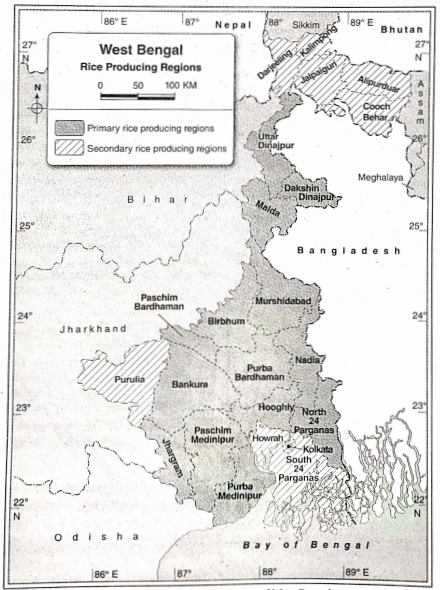
2. Secondary rice-producing regions: Darjeeling, Kalimpong, Alipurduar, Jalpaiguri, Cooch Behar, Purulia, South 24 Parganas, Jhargram, etc. are the secondary rice-producing areas.
Conducive factors for the cultivation of paddy are—
1. Natural/Physical factors:
1. Rainfall: High amount of rainfall is needed during paddy cultivation. Annual rainfall of 150-200 cm is suitable.
However, if annual rainfall is below 100 cm, irrigation is necessary. Thus, paddy cultivation in West Bengal mainly depends on rainfall.
2. Temperature: About 10°C-20°C temperature is needed from the time of planting to the time of sapling. 35°C – 37°C temperature is needed at the time of harvesting.
3. Soil: Fertile silty or alluvial soil is needed for paddy cultivation. Besides, loamy, clayey and sandy soils, laterite soil of the ‘Terai’ and hilly soil are also suitable for paddy cultivation.
4. Land: Though all types of land are suitable, plains which are flat are ideal for paddy cultivation. This is the reason why riverine flood plains are ideal for paddy cultivation.
2. Man-made factors:
1. Labour: Being a labor-intensive cultivation, the densely populated regions produce more paddy.
2. Transport: Since rapid and developed modes of transport are needed, areas having such facilities are ideal for paddy cultivation.
3. Demand: Demand is high, particularly in the densely populated region and paddy cultivation has gained much importance here.
Question 4 What are Jute producing districts 3.a1. ;0f west Bengal? Write about the factors that influence jute production.
Answer: Jute-producing districts of West Bengal: Jute is one of the main cash crops of West Bengal. It is a fiber crop and West Bengal is the largest producer of this crop.
Jute-producing districts of West Bengal are—
1. Primary jute-producing districts: Nadia, Murshidabad, North and South 24 Parganas, Howrah, Hooghly, etc. are the main jute-producing districts of West Bengal.
2. Secondary jute-producing districts: Cooch Behar, Jalpaiguri, Malda, Uttar, and Dakshin Dinajpur, Purba Medinipur, Purba Bardhaman, etc. are the secondary jute-producing districts of West Bengal.
Factors influencing jute production: Factors that influence jute production in West Bengal are—
1. Physical factors:
1. Temperature: About 22°C-35°C temperature is needed for jute cultivation.
2. Humidity: Humidity for jute cultivation must be within 57%-97%.
3. Rainfall: About 100 cm-200 cm of rainfall is needed for jute cultivation. Less than 100 cm of rainfall may disrupt production.
3. Land: Flat and fertile land with proper irrigation facilities is needed for jute cultivation. Because waterlogged land is harmful to jute plants.
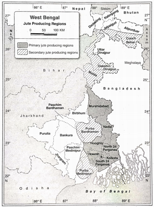
2. Man-made factors:
1. Labour: Sufficient number of labor is required for jute cultivation.
2. Fertilizers: Fertilizers that are made of nitrogen, potassium, and phosphorus are good for jute production. Proper use of fertilizer and pesticides are also required.
3. Transport: Jute is a cash crop and proper transport facilities are needed for commercial benefits.
4. Other: Market demand for jute products is also an important factor. Jute products are biodegradable and eco-friendly. Nowadays demand for jute is huge.
Question 5 Mention the tea-producing regions of West Bengal. Describe the conducive factors for tea cultivation.
Answer: Tea-producing regions of West Bengal: Tea is a mild beverage and is a commercial/cash crop. Tea plantations are mostly found in tropical and subtropical regions. West Bengal ranks second in the production of tea in India.
Tea-producing regions of West Bengal can be classified into— 1. primary and 2. secondary regions.
1. Primary tea-producing regions:
Best-quality flavored tea is produced in the Darjeeling district. Along the hilly slopes ranging between 900 m to 2000 m altitude, terraces have been made for tea plantations. The most important tea producers here are Happy Valley, Sukhiapokhri, Kurseong, Makaibari, Bijanbari, etc.
2. Secondary tea-producing regions: Some other tea plantations are seen in Kalimpong, Jalpaiguri, and the foothills of the Himalayas in the district of Alipurduar. Tea is also produced in the foothills of the Himalayas of the Dooars region. Important tea-producing centers of Dooars are Mai, Binaguri, Madarihat, Chelsea, Naxalbari, Kumargram, Nagarkata, etc.
Conducive factors for tea cultivation: Conducive factors for the cultivation of tea can be grouped into—
1. Physical environment: The important factors are—
1. Relief: Relief is an important factor in the cultivation of tea. Sloping land where water does not stand is required for tea cultivation and that is why hilly slopes are ideal locations. Since hilly soil areas are prone to erosion, terraces have been prepared along the contours for tea plantations.
2. Climate: Hot and wet climates having a high amount of rainfall are necessary since they influence the flavor, color, and taste of tea. Rainfall ranging between 150 cm and 200 cm, an average annual temperature of 20°C-30°C, and a summer temperature of 27°C, is ideal for southwest monsoon. This wind is uncertain thus causing flood or drought. Therefore, irrigation is important to reduce the uncertainty of agriculture in West Bengal. for tea cultivation. Snowfall is harmful to tea plantations.
3. Soil: Fertile, acidic, iron and manganese-bearing soils are ideal for tea cultivation. However, sufficient amounts of nitrogen, zinc, and potassium are also needed.
2. Man-made factors: Some of the important man-made factors are—
1. Capital: Capital is needed for the maintenance of tea gardens, labor wages, implements fertilizers, pesticides, etc.
2. Labour: Skilled workers are required to pick tea leaves. A large number of laborers are required for the tea
processing work.
3. Transport: Developed transport system is essential for exporting after processing it (since tea plantations are
located in hilly areas).
4. Others: Besides the above factors, advanced technology, demand for tea, administrative facilities, market, etc.,
Chapter 8 West Bengal Short Explanatory Answer Type Questions
Chapter 8 West Bengal Short Answer Type Questions
Question 1 West Bengal is famous for the cultivation of which crops?
Answer: West Bengal is famous for the cultivation of crops such as paddy, jute, tea, etc.
Question 2 Which districts of West Bengal are well-known for paddy cultivation?
Answer: Purba Bardhaman, Paschim Bardhaman Nadia, Murshidabad, Hooghly, North and South 24 Parganas, Purba and Paschim
Medinipur districts of West Bengal are well-known for paddy cultivation.
Question 3 Which is the best place for tea cultivation in West Bengal?
Answer: In the northern parts of Darjeeling and Jalpaiguri districts and some places of North Dinajpur, tea is well-cultivated.
Question 4 How many types of paddy are cultivated in West Bengal on the basis of seasons?
Answer: Three types of paddy are cultivated in West Bengal based on the seasons in which they are cultivated —
1. Aman (July- November)
2. Aus (April-August)
3. Boro (November – March)
Question 5 What are the two main characteristic features of agriculture in West Bengal?
Answer:
The two main characteristics of agriculture in West Bengal are—
1. Agriculture is dependent on monsoon winds.
2. Agriculture is labor-intensive.
Question 6 On the basis of seasons, how many types can the crops of West Bengal be divided?
Answer:
On the basis of seasons, the crops of West Bengal can be classified into two types—
1. Kharif crops—paddy, jute, etc.
2. Rabi crops—wheat, potatoes, etc.
3. Zaid crops—maize, groundnut, vegetables, etc.
Question 7 Name the high-yielding variety of jute seeds.
Answer: The high-yielding variety of jute seeds are— Chaitali, Basudev, Sobujsona D-154, JRC- 1108, etc.
Question 8 Mention some tea-producing areas of Darjeeling.
Answer: Happy Valley, Sukhiapokhri, Kurseong, Makaibari, Bijanbari, etc., are some of the notable tea-producing areas of Darjeeling.
Question 9 Name some of the tea-producing areas of the Dooars and Terai region.
Answer: Mai, Jayanti, Chalsa, Nagarkata, Madarihat, Kumargram, etc., are some of the tea-producing areas of the Dooars and Terai region.
Question 10 Write about the uses of jute.
Answer: Jute is the main fiber crop of West Bengal. Its main uses are—
1. Ropes, hawser, etc are made of Jute.
2. Jute is used for the manufacturing of clothes and garments.
3. Jute is used for making a large variety of products such as Hessians, sacks, bags, gunny bags, etc.
4. Dolls, fancy things for house decoration, etc. are made of Jute.
5. Door mats, carpets, and papers are also made of jute.
Chapter 8 West Bengal Fill In The Blanks With Suitable Words
1. Purba district is known as the ‘Rice bowl’ of West Bengal.
2. Jute Bardhaman is called golden fiber.
3. Sabujsona is a high-yielding jute seed.
If The Statement Is True, Write True And If False, Write False Against The Following
1. The main commercial crop of West Bengal is potatoes. False
2. Tea is a cash crop. True
3. Crops that are cultivated for earning money, are called cash crops. True
4. lute is the main agricultural crop of the Rarh region. True
5. Oolong tea is very famous in China. True
6. Purba Bardhaman district is called the ‘Rice bowl of West Bengal’. True
7. Kharif crops are sown in the winter season. False
Chapter 8 West Bengal Match The Left Column With The Right Column
1.
Answer: 1-D,2-C,3-B,4-A
Chapter 8 West Bengal Answer In One Or Two Words
Question Which position does West Bengal hold in India in terms of paddy cultivation?
Answer: First.
Question 2 Name two commercial crops grown in West Bengal.
Answer: Tea and jute.
Question 3 Name a jute research institute in West Bengal.
Answer: Nilgunj near Barrackpore.
Question 4 Which two types of plantation crops are grown in West Bengal?
Answer: Tea and cinchona.
Question 5 Name two food crops grown in West Bengal.
Answer: Paddy and wheat.
Question 6 Name two fiber crops grown in West Bengal.
Answer: Jute and shon.
Question 7 Name an aromatic variety of rice which grows in West Bengal.
Answer: Gobindobhog.
Question 8 What are the main crops of West Bengal?
Answer: Rice, Jute, Tea, etc.
Question 9 Name the associate port of Kolkata.
Answer: Haldia.
Chapter 8 West Bengal Topic G Industry Long Answer Type Questions
Chapter 8 west Bengal Short Explanatory Answer Type Questions
Chapter 8 West Bengal Short Answer Type Questions
Question 1 What is information technology?
Answer: Information technology refers to the storage, receiving, sending, coding, decoding, and editing of data with the help of computers and telecommunication.
Question 2 What are the different parts of the information technology industry?
Answer: Collection of data, analysis of collected data, research, transformation, and deletion of data through the computer and telecommunication systems are used for business purposes.
The main sections of IT industries are software production, telephone service, center for data collection and maintenance, data exchange centers, etc.
Question 3 State the major companies associated with the food processing industry of West Bengal.
Answer: The major food processing companies are— Mother Dairy, Haldiram’s, Anmol Biscuit Limited, Raja Biscuit, K C Das and Sons, etc.
Question 4 Where and when was the first jute mill established in West Bengal?
Answer: The first jute mill was established in Rishra of the Hooghly district of West Bengal in 1855.
Question 5 When and where was the first cotton mill established in Kolkata?
Answer: The first cotton mill was established in 1818 in Ghusuri of Howrah.
Question 6 What is outsourcing?
Answer: The process of carrying out work in a comparatively cheaper way and increasing the standard and skill of a company, by an overseas organization is called outsourcing. Since the service cost is less in India, much of the work from America and Europe are sent here (in the form of data) which is processed and sent back. Kolkata is a leading provider of outsourcing.
Question 7 What is the food processing industry?
Answer: The industry that deals with the packaging and processing of food is called the food processing industry. In this industry, food that is perishable and cannot be consumed directly is processed through different scientific processes, like preservation, refrigeration, canning, irradiation, drying, salting, smoking, and fermentation. Examples—are fruit juice, jam, jelly, pickle, and chips-producing industries.
Chapter 8 West Bengal Fill in the blanks with suitable words
1. Durapur is called the ‘Ruhr of India’.
2. The first iron and steel industry was established at Kulti in West Bengal in 1870.
3. The product quality of food processing industries in West Bengal at Barasat
Chapter 8 West Bengal If The Statement Is True, Write True, And If False Write False Against The Following
1. Rajarhat-Newtown is an information technology hub in Kolkata. True
2. Haldia is an important industrial zone of West Bengal. True
3. Siliguri is called the ‘Iron and Steel City. False
4. Howrah is known as the ‘Sheffield of India’. True
Chapter 8 West Bengal Match the Left column with the Right column
1.
| Left Column | Right Column |
| 1. Iron and Steel | A. Budge Budge |
| 2. Tea | B. Durgapur |
| 3. Jute | C. Rajarhat |
| 4. Information and – Technology | D. Alipurduar |
Answer:1-B,2-D,3-A,4-C
2.
| Left Column | Right Column |
| 1. Cotton-textile industrial center | A. Sea beach of Digha |
| 2. Jute industrial centre | B. Shankarpur |
| 3. Tourism center | C. Ghusuri in Howrah district |
| 4. Food-processing center | D. Rishra in Hooghly district |
Answer:1-C,2-D,3-A,4-B
Chapter 8 West Bengal Answer in One Or Two Words
Question 1 Which city is called the ‘Ruhr of India’?
Answer: Durgapur.
Question 2 Name two areas of the fish processing industry.
Answer: Shankarpur and Jaunput.
Question 3 Name two areas of the milk processing industry.
Answer: Dankuni and Asansol.
Question 4 Name two centers of mineral water
Answer: processing in West Bengal Kalyani and Berhampore.
Question 5 Name two food parks of West Bengal.
Answer: Shankarpur and Kakdwip.
Question 6 Which city is called the ‘Glasgow of India’?
Answer: Howrah.
Question 7 What is the full form of SEZ?
Answer: Special Economic Zone.
Question 8 What is the main industry of Hooghly industrial belt?
Answer: Jute industry (in dissenting opinion engineering industry).
Question 9 What is the full name of SAIL?
Answer: Steel Authority of India limited.
Question 10 Which is the largest cottage industry in West Bengal?
Answer: Handloom industry.
Question 11 Which industry is called the ‘Sunset industry’ in India?
Answer: Jute industry (In dissenting opinion petrochemical industry).
Question 12 Where has the rope-making industry developed in Wet Bengal?
Answer: Uluberia in Howrah district.
Chapter 8 West Bengal Topic H City, Port And Tourist Place Long Answer Type Questions
Chapter 8 west Bengal Short Explanatory Answer Type Questions
Chapter 8 West Bengal Short Answer Type Questions
Question 1 What is a city?
Answer:
City:-
A city is a place where the minimum population is at least 5000 and the population density is more than 400 per sq km and at least 75% of the total population is engaged in non-agricultural activities. For example, Asansol.
Question 2 What is megalopolis?
Answer:
Megalopolis:-
The Greek word ‘Megas’ means big. Megalopolis means a big city. It has a population of more than 10 lakhs. For example, Koikata.
Question 3 Mention some of the tourist places in Kolkata.
Answer:
Tourist Places In Kolkata:-
The tourist places of Koikata are—Indian Museum, Victoria Memorial Hall, Birla Planetarium, Science City, etc.
Question 4 Who established the city of Kolkata and when?
Answer:
City Of Kolkata:-
Kolkata was founded by Job Charnock in 1690. The city was founded by combining the 3 villages of Kolkata, Sutanuti, and Gobindapur.
Chapter 8 West Bengal Fill The Blanks With Suitable Words
1. Apart from Kolkata, Haldia is an important part of West Bengal.
2. Kolkata is called the ‘City of Palaces’.
3. As per the census report, 2011, the population of West Bengal is 91,276,115
4. As per the census report, 2011, the population density of West Bengal is 1028 person/sq km
5. Hazarduari is situated in the Murshidabad district
6. The biggest city of the Ganga delta region is Kolkata
7. A tourist spot in West Bengal is a tiger
8. According to population density West Bengal ranks second position in India.
9. Imambara is located in the Hooghly district.
10. English Bazar is the headquarters of Malda district.
11. Siliguri is the Gateway of north-east
Chapter 8 West Bengal If The Statement Is True, Write True, And If False Write False Against The Following
1. The highest railway station in India is Ghoom. True
2. Pedong is a small town near Kalimpong. True
3. A historical tourist spot in West Bengal is Hazarduari. True
4. Darjeeling is a hill station. True
5. The headquarters of Murshidabad district is Chin sura. False
6. Kolkata and Howrah are called Twin Cities. True
7. Sajnekhali is a spectacular spot in the Sundarbans. True
8. Berhampore is called the ‘City of Palaces’. False
9. Hoogly port is a contemporary or supportive port of Kolkata port. False
10. Bird sanctuary is located in the Jalpaiguri district. False
Chapter 8 West Bengal Matches The Left Column With The Right Column
1.
| Left Column | Right Column |
| 1. Glasgow of India | A. Durgapur |
| 2. Ruhr of India | B. Siliguri |
| 3. Capital of west bengal | C. Howrah |
| 4. Gateway to northeast India | D. Kolkata |
Answer: 1-C,2-A,3-D,4-B
2.
| Left Column | Right Column |
| 1. Jaldapara | A. Botanical garden |
| 2. Shibpur | B. Hazarduri |
| 3. Murshidabad | C. Victoria memorial |
| 4. Kolkata | D. One-horned rhinoceros |
Answer: 1-D,2-A,3-B,4-C
Chapter 8 West Bengal Answer In One Or Two Words
Question 1 Balurghat is the headquarters of which district?
Answer: Dakshin Dinajpur.
Question 2 Which city is called the ‘City of Joy’?
Answer: Kolkata.
Question 3 What is the capital of West Bengal?
Answer: Kolkata.
Question 4 In which district is Bolpur located?
Answer: Birbhum.
Question 5 Which is the ‘commercial hub’ of north Bengal?
Answer: Siliguri.
Question 6 Name the associate port of Kolkata.
Answer: Haldia.
Question 7 How many ‘million cities’ are there in West Bengal?
Answer: Two.
Question 8 In which district is the Iscon temple located?
Answer: Nadia.
Question 9 What is the main attraction of Jaldapara National Park?
Answer: One-horned rhinoceros.
Question 10 Which city is called ‘the black diamond city’ of West Bengal?
Answer: Asansol.
Chapter 8 West Bengal Map Pointing
Question 1 Locate the following with appropriate symbols and names on an outline map of West Bengal.
Answer:
1. Northern hilly region of West Bengal
2. Haldia port
3. River Damodar
4. A main rice-producing region
5. An iron and steel industrial region
6. A jute industrial region
7. Krishnanagar
8. Coastal soil region
9. A newly formed district
10. A food processing industrial center
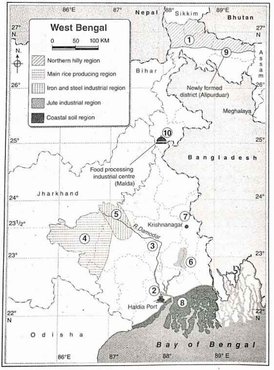
Question 2 Locate the following with appropriate symbols and names on an outline map of west bengal
Answer:
1. River Bhagirathi
2. Kolkata
. A place receiving high rainfall
4. Mangrove forest
5. The main tea-producing region
6. A thermal power plant
7. Santiniketan
8. Balurghat
9. Rarh plains
10. River Ajoy
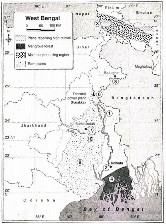
Question 3 Locate the following with appropriate symbols and Bengal.
Answer:
1. Ajodhya hills
2. RiverTeesta
3. Digha
4. Bakreswars. The soil of the plateau region
6. Siliguri
7. Kolkata port
8. An iron and steel industrial center
9. Sandakphu
10. A jute-producing region
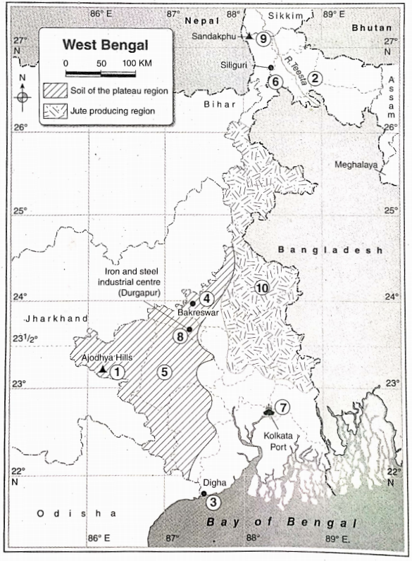
Question 4 Locate the following with appropriate symbols and names on an outline map of West Bengal
Answer:
1. The coldest district of west bengal
2. Bakkhail
3. River Ganga
4. plateau region of west bengal
5. Soil of the terai region
6. A historical region place
7. jaldapara national park
8. Tropic of cancer
9. Haldia indusrtrial region
10. An active delta region
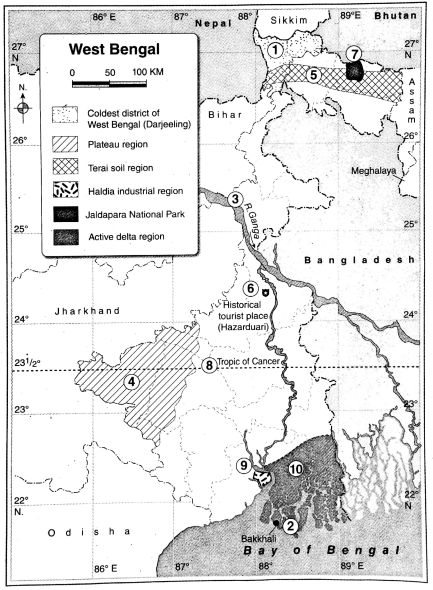
Question 5 Locate the following with appropriate symbols and names on an outline map of West Bengal
Answer:
1. A hill station
2. Plains of North Bengal
3. River Mahananda
4. An information technology industrial center
5. City of Palaces
6. Alipurduar
7. Berhampore
8. A food processing research center
9. Susunia Hills
10. A land port