WBBSE Solutions For Class 8 Geography Chapter 10 South America Topic A General Introduction And Physical Environment Of South America

Chapter 10 South America Synopsis

  • The longest mountain range of the world, the Andes, is situated in South America. It is the second-highest mountain range after the Himalayas.
  • The Amazon, the longest river of South America is the largest river of the world in terms of the volume of water discharged. It is the second-longest river of the world.
  • Angel Falls (979 m) of Venezuela is the highest waterfall of the world.
  • The highest navigable lake of the world, the Titicaca, is located in the Andes mountains of South America. the Andes
  • South America ranks fourth among the continents in terms of area and this continent is 5.5 times larger than India in terms of area.
  • South America extends from 12°28′ N to 55°59′ S latitudes and from 34°50′ W to 81°20′ W longitudes.
  • South America is separated from North America by the Panama Canal.
  • Central America, South America, Mexico and Caribbean Islands are collectively known as Latin America. This is because the languages of these regions are derived from the ancient Latin language.
  • Numerous volcanoes, mostly active, e.g. the Chimborazo and the Cotopaxi are located in this continent. These are the first and second highest active volcanoes on the earth respectively.

Read and Learn More WBBSE Solutions For Class 8 Geography

  • The Atacama Desert (about 1100km) lies in the northern part of Chile. It is one of the driest deserts in the world.
  • Guiana Highlands (average height 800m) and Brazilian Highlands (average height 1000m) to the east of South America are basically old shield regions.
  • The Mato Grosso Plateau is situated in between the Brazilian Highlands and the Andes.
  • The Amazon flows into the Atlantic Ocean with a huge volume of water and decreases the salinity of the water in this region. No delta has formed at the mouth of the Amazon.
  • 70% area of South America is situated in the torrid zone, 20% in the warm temperate zone and the remaining 10% in the cold temperate zone.

Class 8 Geography WBBSE

  • The humid north-west westerlies get obstructed by the Andes between 40°S and 60°S latitudes. As a result, very little rainfall is experienced on the leeward side of the mountain and thus the Patagonia desert has formed there.
  • South-east trade winds are interrupted by the Andes mountain resulting in a rain shadow area in the western part of the mountain. As a result, the Atacama desert is formed in the western part of the continent.
  • The major tree species of the equatorial region are mahogany, rosewood, ironwood, brazil nut, etc. The trees grow so densely that sunlight does not penetrate till the ground of the forests. That is why this region is known as the Land of Eternal Twilight.
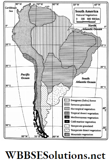
  • World’s largest tropical evergreen rainforest, the Selva, has developed in the Amazon River basin. The average temperature and average annual rainfall of this forest are 25°C-27°C & 250cm-300 cm respectively.
  • The trees are found in the tropical evergreen. Forests are tall with strong and thick trunks and have very hard wood. The trees have big leaves with numerous stomata.
  • Branches of tall trees entangle with each other and form canopies in the upper layer of the forest. This prevents sunlight from reaching the lower layers of the forest. Hence, the lower layers remain dark and damp.
  • The Selva provides 20% of the world’s total oxygen and hence, this forest is referred to as the ‘Lungs of the World’.
  • The Amazon rainforest is the habitat of 10 per cent of living organisms in the world. This region is home to about 2.5 lakh insect species and 4 lakh species of plants.
  • The Pampas grassland extends over the La Plata basin of Argentina and Uruguay. The shape of this grassland is like a half-moon. This region extends from 30°S to 38°S latitudes and from 54°W to 65°W longitudes.
  • The main rivers of the Pampas region are the Parana and Paraguay. Both rivers merge with the Uruguay River near Buenos Aires the capital of Argentina. The combined flow of these rivers is known as the La Plata.
  • The Pampas region is highly developed in agriculture. Wheat is the principal crop produced here. The other crops that are grown here include corn, barley, cotton, maize, sugarcane, etc. This is why the Pampas region is known as the Granary of South America.
  • The grazing areas of the Pampas region are locally called ‘Estancia’.

Chapter 10 Topic A General Introduction And Physical Environment Of South America Analytical Type Questions

Question 1. Discuss the geographical location and size of South America.
Answer: The geographical location and size of South America are discussed below-

Geographical location:

South America lies to the south of the North. America is surrounded by the Atlantic Ocean in the east, the Pacific Ocean in the west and the Antarctic Ocean in the south.

Class 8 Geography WBBSE

The continent has a triangular shape. The location of South America can be discussed under the following heads-

1. Latitudinal:

South America extends from 12°28′ N to 55°59′ S. This implies that the Equator (0°) and the Tropic of Capricorn (23°30’S) pass through the continent.

2. Longitudinal:

South America extends from 34°50′ W in the east to 81°20′ W in the west.


WBBSE Solutions For Class 8 Geography Chapter 10 Topic A General Introduction And Physical Environment Of South America Geographical location of south america

3. Hemisphere:

About 85 per cent of the continent lies in the southern hemisphere. South America is often referred to as a continent of the southern hemisphere.

4. Boundaries:

This continent is flanked by seas And oceans-Panama Canal and the Caribbean Sea in the north, the Pacific Ocean in the west, the Atlantic Ocean in the east and the Antarctic Ocean in the south.

Size:

Class 8 Geography WBBSE

In terms of size, South America is the fourth largest continent in the world (17,840,000 sq. km area). South America is about twice the size of Europe and five times that of India.

Question 2. Give a brief description of the topography of South America.
Answer:

Topography Of South America:-

The topography of South America is classified into four categories based on the features of the landforms-

  1. The Western Mountain Region,
  2. Narrow Coastal Plains of the west,
  3. Eastern Highland Region,
  4. The extensive Central Plain.

1. The Western Mountain Region:

The mountain region in the west of South America covers the Andes Mountain ranges. The Andes Range is the longest Coastal Plain of a continuous chain of mountains in the world. It extends from Panama in the north to Cape Horn in the south.

It is the second-highest mountain range in the world. The Andes is a chain of young fold mountains and hence is geologically active. This leads to frequent earthquakes and volcanic eruptions.

WBBSE Solutions For Class 8 Geography Chapter 10 Topic A General Introduction And Physical Environment Of South America Topographic division of south America

The entire region of the Andes is part of the Pacific Ring of Fire: Mt. Chimborazo (6272 m) and Cotopaxi (5896 m) are the first and second highest active volcanoes on Earth respectively.

The highest mountain peak in the Andes is the Aconcagua (6960m). World’s highest lake, Titicaca (3810m) is located in this area.

2. Narrow Coastal Plains of the West:

Besides the Central Plains, there are narrow stretches of plain lands lying along the western, eastern and northern coasts of South America. In the western part, the Andes descend abruptly into the ocean.

Class 8 Geography WBBSE

Thus, it can be said that the coastlines barely exist here. Atacama desert, about 1100 km long lies in the middle of this region. This is one of the most driest and drought-prone areas of the world.

On the other hand, the coastal plains are quite extensive in the eastern as well as the northern parts, near the Amazon and the La Plata river basins.

3. Eastern Highland Region:

The Eastern Highlands consist of the Guiana Highlands (average height 800 m) in the north, the Brazilian Highlands (average height 1000m) in the east and the Patagonian Plateau region in the south.

The Amazon separates the Guiana Highlands from the Brazilian Highlands. The Mato Grosso plateau exists between Brazilian Highlands and the Andes.

This area acts as a watershed between Amazon and La Plata rivers. The Angel Falls in Venezuela is in the Guiana Highlands. It is the world’s highest waterfall (979 m) and is situated on a tributary of the river Orinoco.

Roraima (2769 m) is the highest peak of the Guiana Highlands. The Brazilian Highlands extend over a larger area and are higher than the Guiana Highlands. The Brazilian Highlands cover the eastern part of South America.

The central parts of the Brazilian Highlands are occupied by the Campos grasslands. Pico-da-Banderia is the highest peak of this region located along the coastal zone of the Atlantic Ocean in the south-eastern margin of this highland.

The rivers San Francisco and the Parana flow through these highlands. The Patagonian Plateau is situated close to the southern part of the Andes and the western part of Argentina. This region gradually slopes down to the Atlantic Ocean.

The climatic condition in the plateau region is arid. Patagonia is a large cold desert and experiences an average temperature of 3°C.

WBBSE Solutions For Class 8 Geography Chapter 10 Topic A General Introduction And Physical Environment Of South America Physiographic division of south america

4. The extensive Central Plain:

These plains consist of three large river basins-the Orinoco river basin, the Amazon river basin and the La Plata river basin. The Central Plains refer to the vast stretch of plainland that lies between the Andes and the Eastern Highlands.

The Orinoco river originates in the Guiana Highlands and after travelling through Venezuela and Colombia, meets the Atlantic Ocean. The Orinoco River basin covers the northern region of South America.

WBBSE Class 8 Geography Chapter 10

Question Answer

The World’s largest river in terms of water discharge, is the Amazon. The rainforest formed along the Amazon River basin is the largest in the world.

The Amazon originates in the Andes and after travelling through Peru, Ecuador, Colombia and Brazil, it drains into the Atlantic Ocean. The La Plata basin consists of three major rivers-the Parana, Paraguay and Uruguay.

These rivers originate in the Brazilian Highlands and join the Atlantic Ocean. The river basin is in the southern part of the continent.

Question 3. What are the major rivers in South America? Give a brief account of these rivers.
Answer:

Rivers of South America:

The major rivers in South America are the Amazon, the Orinoco, the La Plata and the Sao Francisco. Most of the rivers in South America originate either in the Mato Grosso Plateau region or in the western parts of the Andes and then flow into the Atlantic Ocean in the east.

Overview of the rivers of South America:

An overview of the rivers is given below-

WBBSE Solutions For Class 8 Geography Chapter 10 Topic A General Introduction And Physical Environment Of South America Overview of the river of south America


WBBSE Solutions For Class 8 Geography Chapter 10 Topic A General Introduction And Physical Environment Of South America Rivers Of South America


Question 4. Describe the topography of the northern and eastern highlands or plateaus.
Answer:

Topography of the Highland:

The plateaus that extend over a considerable area in the north of South America are of residual type. Various forms of erosion over the years have led to a reduction in the height of these plateaus.

The plateau region that stretches across Venezuela, Guyana, Surinam, French Guiana and Brazil are called the Guiana Highlands.

However, since these highlands rise to considerable heights in Venezuela, some mountain ranges have also developed here. Roraima (2769 m) is the highest peak in this upland.

WBBSE Class 8 Geography Chapter 10 Question Answer

Topography of the Eastern Highland:

The eastern highlands of South America are called the Brazilian Highlands, while the central highlands are called the Mato Grosso Plateau region. This plateau actually connects the Brazilian Highlands in the east with the Andes in the west.

The sharp edges of the Brazilian Highlands abruptly descend to the Atlantic Ocean in the east. On the other hand, in the west, these highlands gradually become sloping and blend with the central plain lands.

A major area of the Brazilian Highlands is occupied by the Campos grassland. The average elevation of the highlands is 1000 metres and the highest mountain peak in this region is this Pico-da-Bandeira.

Question 5. What are the determinants of the climatic diversity prevailing in South America? Or, Discuss the factors affecting the climatic characteristics of South America.
Answer: The main determinants of the climatic characteristics of South America are-

1. Shape of the continent:

The continent has a wide and extensive northern part and a southern part that gradually tapers. So, South America appears triangular in shape. That is why no maritime effects are seen in the interior of the northern parts of this continent.

Most of South America lies to the south of the equator, while a considerably small part in the north of the continent lies to the north of the equator.

As a result, the northern and the southern parts of South America experience opposite seasons during the same time.

2. Latitudinal extent:

The maximum portion of South America is in the tropical zone because it extends from 55°59′ S to 12°28′ N latitudes. The areas in the equatorial zone experience is extremely hot climates.

However, places located at high latitudes in the southern hemisphere experience comparatively cooler climates.

3. Distance from the sea:

The southern part of the continent is narrow. Some regions in this part are only 250 km away from the sea. Hence, these regions experience a maritime climate (moderate).

On the other hand, the regions in the north experience a continental type of climate (extreme) because of their huge distance from the sea.

4. Effect of the Equator and the Tropic of Capricorn:

The equator passes through the Amazon river basin in the north, which causes an equatorial type of climates to prevail in these regions. On the other hand, the Tropic of Capricorn passes through the central part of the southern region.

This leads to hot tropical climate in the north and cool temperate climate in the south. Actually, 70% area of this continent lies in the torrid zone, 20% in the warm temperate zone and 10% in the cold temperate zone.

WBBSE Class 8 Geography Chapter 10 Question Answer

5. Location of the Andes:

The Andes mountain range occupies the western part of South America and it extends from the north to south in a long, continuous chain.

The Andes acts as a barrier to the moist winds, as a result of which very little rainfall is experienced on the leeward side of the mountain. This leads to the formation of a rainshadow region here.

6. Ocean currents:

The cold Humboldt Current or the Peru Current that moves across the southwestern coast leads to a cold and dry climate in these regions.

Similarly, the warm Brazil Current that moves along the eastern coast leads to the development of hot and humid climate in these regions.

7. Constant flow of trade winds:

The northeast trade winds blowing from the north and the southeast trade winds blowing from the south lead to heavy rainfall in these regions throughout the year. The northwest westerlies also cause heavy rainfall in the southern parts of Chile.

8. Elevation of land:

The higher regions of the Andes experience a pleasant and cool climate due to their high altitude. The Brazilian and the Guiana Highlands also experience cool climates due to their comparatively high altitudes, in spite of being located in the torrid zone.

Question 6. Write about the various climatic regions of South America.
Answer:

Various Climatic Regions Of South America:-

The climatic regions of South America can be classified into the following nine categories based on temperature, rainfall, air pressure, etc. These are discussed in the following table-

WBBSE Solutions For Class 8 Geography Chapter 10 Topic A General Introduction And Physical Environment Of South America Various Climatic regions of South America


WBBSE Solutions For Class 8 Geography Chapter 10 Topic A General Introduction And Physical Environment Of South America Climatic regions of south America

Question 7. Write about the characteristic features of the topography and rivers of the Amazon river basin.
Answer:

Characteristic features topography of the Amazon River basin:

The topographic characteristics of the Amazon River basin are as follows-

  1. The central region of the Amazon River basin is almost plain.
  2. From this central region, the land has gradually elevated in three sides-the Guiana Highlands in the north, the Brazilian Highlands in the south and the Andes mountain range in the west.
  3. The river does not form any delta at its mouth and flows uninterruptedly towards the east into the Atlantic Ocean. Hence, the shape of the river basin is like a funnel.
  4. This region naturally slopes from west to east.
  5. The river basin has developed as a result of silt deposition by the Amazon and its tributaries.
  6. The Amazon has a wide mouth and some islands have developed there. Among these, Marajo is the largest fluvial island in the world.
  7. The Amazon River basin consists of flood plains, ox-bow lakes, swamps and islands.

Characteristic features of the rivers of the Amazon basin:

WBBSE Class 8 Geography Chapter 10 Question Answer

The characteristic features of the rivers of the Amazon River basin are as follows-

1. Amazon:

The Amazon is the largest river in the world, in terms of the volume of water it carries and the area of the river basin. It is the longest river in South America.

It originates in the Mismi mountain peak in the Andes. Then it travels first across the north and then across the east to join the Atlantic Ocean. The Amazon River basin is located in the equatorial region that receives heavy rainfall.

WBBSE Solutions For Class 8 Geography Chapter 10 Topic A General Introduction And Physical Environment Of South America location of Amazon Basin

So, a large volume of rainwater, collected by several tributaries, gets accumulated in the Amazon river. From the origin to the mouth, the length of the river is 6437 km.

The left bank tributaries of the river are-Napo, Negro, Japure, etc., and the right bank tributaries are Jurua, Purus, Madeira, Tapajos, Xingu, etc.

2. Other rivers:

Most of the other rivers that flow through the Amazon River basin are its tributaries. Among these, the main rivers are Madeira, Tapajos, Xingu, Jurua, Negro, Japura, etc.

The Madeira (3250 km) carries a large volume of water and discharges into the Amazon. It is the largest tributary of the Amazon River.

Question 8. Briefly discuss about the natural vegetation of South America.
Answer:

Natural Vegetation Of South America:-

The natural vegetation of South America can be classified into nine categories based on the nine climatic regions. The relationship between climate and vegetation is very close.

The vegetation zones of South America are discussed in the following table-

WBBSE Solutions For Class 8 Geography Chapter 10 Topic A General Introduction And Physical Environment Of South America VegetationWBBSE Solutions For Class 8 Geography Chapter 10 Topic A General Introduction And Physical Environment Of South America Vegetation.WBBSE Solutions For Class 8 Geography Chapter 10 Topic A General Introduction And Physical Environment Of South America Vegetation..


WBBSE Solutions For Class 8 Geography Chapter 10 Topic A General Introduction And Physical Environment Of South America Natural Vegetation of south America

Chapter 10 Topic A General Introduction And Physical Environment Of South America Short Analytical Type Questions

Question 1. What is the Strait of Magellan?
Answer:

Strait Of Magellan:-

The narrow waterbody or passage of water that joins two waterbodies and separates two land masses is called a strait.

The waterbody that exists between the Tierra del Fuego islands and the main landmass of South America is called the Strait of Magellan.

WBBSE Class 8 Geography Chapter 10 Question Answer

The Portuguese explorer Magellan reached the Pacific Ocean through this strait, after crossing the Atlantic Ocean. Hence, the strait has been named after the explorer.

WBBSE Solutions For Class 8 Geography Chapter 10 Topic A General Introduction And Physical Environment Of South America Strait o Magellan

Question 2. Why is South America also called ‘Latin America’?
Answer:

South America Also Called ‘Latin America’:-

Latin America actually refers to South America as well as Mexico, the Caribbean Islands and the countries of Central America. This region is dominated by Spanish, Portuguese, French and Italians.

Thus the language of the first colonial settlers is widely spoken in this region. These languages have been originated from Latin, the ancient classical language.

Still, now these are practised in Middle and South America. So the region is called Latin America.

Question 3. Mention the main physiographic divisions of South America. Explain briefly about any one of them. Or, Divide South America into physiographic regions. Give a brief. account of any one of them.
Answer: Based on topography, South America has been classified into four physiographic divisions.

These are

  1. The western mountain region,
  2. Narrow coastal plains of the west,
  3. The eastern highland region,
  4. The extensive central plains and

1. The Western Mountain Region:

The mountain region in the west of South America covers the Andes Mountain ranges. The Andes Range is the longest Coastal Plain of a continuous chain of mountains in the world. It extends from Panama in the north to Cape Horn in the south.

It is the second-highest mountain range in the world. The Andes is a chain of young fold mountains and hence is geologically active. This leads to frequent earthquakes and volcanic eruptions.

The entire region of the Andes is part of the Pacific Ring of Fire: Mt. Chimborazo (6272 m) and Cotopaxi (5896 m) are the first and second highest active volcanoes on Earth respectively.

WBBSE Class 8 Geography Chapter 10 Question Answer

The highest mountain peak in the Andes is the Aconcagua (6960m). World’s highest lake, Titicaca (3810m) is located in this area.

2. Narrow Coastal Plains of the west:

Besides the Central Plains, there are a narrow stretches of plain lands lying along the western, eastern and northern coasts of South America. In western part, the Andes descend abruptly into the ocean.

Thus, it can be said that the coastlines barely exist here. Atacama desert, about 1100 km long lies in the middle of this region. This is one of the most driest and drought-prone areas of the world.

On the other hand, the coastal plains are quite extensive in the eastern as well as the northern parts, near the Amazon and the La Plata river basins.

3. Eastern Highland Region:

The Eastern Highlands consist of the Guiana Highlands (average height 800 m) in the north, the Brazilian Highlands (average height 1000m) in the east and the Patagonian Plateau region in the south.

The Amazon separates the Guiana Highlands from the Brazilian Highlands. The Mato Grosso plateau exists between Brazilian Highlands and Andes.

This area acts as a watershed between Amazon and La Plata river. The Angel Falls in Venezuela is in the Guiana Highlands. It is the world’s highest waterfall (979 m) and is situated on a tributary of the river Orinoco.

Roraima (2769 m) is the highest peak of the Guiana Highlands. The Brazilian Highlands extend over a larger area and are higher than the Guiana Highlands. The Brazilian Highlands cover the eastern part of South America.

The central parts of the Brazilian Highlands are occupied by the Campos grasslands. Pico-da-Banderia is the highest peak of this region located along the coastal zone of the Atlantic Ocean in the south-eastern margin of this highland.

The rivers San Francisco and the Parana flow through these highlands. The Patagonian Plateau is situated close to the southern part of the Andes and the western part of Argentina. This region gradually slopes down to the Atlantic Ocean.

The climatic condition in the plateau region is arid. Patagonia is a large cold desert and experiences an average temperature of 3°C.

4. The extensive Central Plain:

These plains consist of three large river basins-the Orinoco river basin, the Amazon river basin and the La Plata river basin. The Central Plains refer to the vast stretch of plainland that lies between the Andes and the Eastern Highlands.

The Orinoco River originates in the Guiana Highlands and after travelling through Venezuela and Colombia, meets the Atlantic Ocean. The Orinoco River basin covers the northern region of South America.

The World’s largest river in terms of water discharge, is the Amazon. The rainforest formed along the Amazon river basin is the largest in the world.

WBBSE Class 8 Geography Chapter 10 Question Answer

The Amazon originates in the Andes and after travelling through Peru, Ecuador, Colombia and Brazil, it drains into the Atlantic Ocean. The La Plata basin consists of three major rivers-the Parana, the Paraguay and Uruguay.

These rivers originate in the Brazilian Highlands and join the Atlantic Ocean. The river basin is in the southern part of the continent.

Question 4. Write a brief note on the Andes mountain range.
Answer:

Andes Mountain Range:-

The Andes is the world’s longest range of mountains. It extends from the Caribbean Sea in the north to Cape Horn in the south. This range consists very high mountain peaks and it is the longest mountain chain of the world.

It becomes narrower in the east-western parts. The Andes is a range of young fold mountains and so, the process of its formation is still continuing. As a result of this, the Andes region is highly prone to earthquakes.

The highest peak of the Andes is the Aconcagua (6960 metre). In many places of Andes region, intermontane plateaus are located, such as- Bolivia, Ecuador, Peru, Titicaca, etc. Titicaca Lake (3810m) is the highest lake of the world.

Question 5. Why are the hilly regions of the Andes prone to earthquakes?
Answer:

Hilly Regions Of The Andes Prone To Earthquakes:-

The Andes hilly regions are earthquake-prone, because-

  1. The Andes has developed on the convergence point of the Nazca oceanic plate and the South American continental plate. Since these two plates are dynamic and are moving towards each other, it makes that particular region earthquake-prone.
  2. As a result of the convergence of these two plates, many volcanoes have developed in the Andes region. Due to volcanic eruptions, this region is prone to earthquakes as well.
  3. Since the region is made up of soft sedimentary rocks, landslides are common and the process of land formation is still continuing. Hence, the Andes region is earthquake-prone.

WBBSE Solutions For Class 8 Geography Chapter 10 Topic A General Introduction And Physical Environment Of South America The Andes mountains and its plate region

Question 6. Describe the important volcanoes in South America.
Answer:

Important Volcanoes In South America:-

Aconcagua, the highest mountain peak in South America is an extinct volcano. It is in the west-central Argentine province of Mendoza. and has an altitude of 6960 metres.

Mount Chimborazo (6267 metres) and Cotopaxi (5896 metres) are two notable active volcanoes in Ecuador. These are the first and second highest active volcanoes on the earth respectively.

Both of these are located on the volcanic belt of the Pacific Ocean. [Ojos del Salado, situated on the Chile-Argentina border, is now considered to the highest active volcano in the world.]

Question 7. Briefly discuss the northern plateau region of South America.
Answer:

Northern Plateau Region Of South America:-

Location:

The northern plateau region of South America extends from the Andes in the west to the Atlantic coast in the east. It is as old as the Deccan plateau of India and the Canadian shield of North America.

Characteristics:

The following characteristic features are found in this region-

  1. It is a type of ancient dissected plateau made of hard rock.
  2. Although it is made of hard rock, erosion by natural forces such as wind, rain and river has reduced the height of the plateau to some extent. At present, the average height of the plateau is 800 metres.
  3. Venezuela, Guyana, Suriname, French Guiana and Brazil are the five countries across which the plateau region extends. The region is also known as the Guiana Highlands. Its length is 1600 km, its average height is 300m- 1500m and its maximum height is 3000 m.
  4. The plateau region is quite high in Venezuela because some mountain ranges have also developed there. The region slopes towards the north and east coasts.
  5. Angel, the world’s highest waterfall is located in this upland.
  6. Roraima (2769 m) is the highest peak of this region.

Question 8. Describe the important plains of South river basin and America.
Answer:

Important Plains Of South River Basin And America:-

There is a vast stretch of plainland which extends from north to south of the continent of South America. This region has the Andes mountains to the west, the Guiana Highlands to the north and the Brazilian Highlands to the east.

WBBSE Solutions For Class 8 Geography Chapter 10 Topic A General Introduction And Physical Environment Of South America Plains Of South America

Some important rivers, namely, the Amazon, the Orinoco and the La Plata, pass through this region. According to physical features, this region can be classified into the following four sub-divisions-

  1. Plains of the amazon river basin,
  2. Plains of the Orinoco river basin,
  3. Plains of the la plata river basin and
  4. The parana-paraguay among these, the plains of the amazon river basin are the largest but, they are not flat throughout and have some uneven highlands and hillocks.

The plains of the Amazon are called the Selva, those of the Orinoco are called the Llanos, and the Parana-Paraguay plains are known as the Gran Chaco. The La Plata plains of Argentina are called the Pampas.

Question 9. Describe the central and eastern plateau regions of South America.
Answer:

Central And Eastern Plateau Regions Of South America:-

There is a vast highland region in the eastern and central parts of South America. The eastern part is known as the Brazilian Highland (it occupies almost rd of Brazil’s total area) and the central part is known as the Mato Grosso Plateau.

The following characteristic features are found in this region-

  1. The Mato Grosso Plateau region has actually connected the Andes mountain range in the west with the Brazilian Highlands in the east.
  2. The famous Iguazu waterfall is situated here.
  3. The eastern side of the Brazilian Highlands, i.e., the side towards the Atlantic. Ocean is very steep. However, the western side gradually slopes towards the central plainland. This implies that the highland slopes from east to northwest.
  4. A vast stretch of this highland is occupied by the Campos grassland.
  5. The highlands have an average elevation of 1000 metres. Pico-da-Bandeira is the highest peak of this region.

Question 10. Differentiate between the Brazilian Highlands and the Guiana Highlands.
Answer: The differences between the Brazilian and the Guiana Highlands are as follows-

WBBSE Solutions For Class 8 Geography Chapter 10 Topic A General Introduction And Physical Environment Of South AmericDifferentiate Brazilian and Guiana highlands


Question 11. Classify the central plains of South America according to regional variations.
Answer: The central plains of South America are classified as follows-

WBBSE Solutions For Class 8 Geography Chapter 10 Topic A General Introduction And Physical Environment Of South America Central plains of south America


Question 12. Give a physiographic description of the Amazon River basin.
Answer:

Amazon River Basin:-

In terms of physical features, they can be classified into three main sub-divisions, Amazon river basin is a plainland.

Origin:

The Amazon, passes through the adjacent highlands of the western part of the Andes, the northern part of Guiana Highlands and the southeastern part of the Brazilian Highlands.

Along its course, the river has transported and accumulated sand and silt to form the vast Amazon River basin.

Features:

  1. The size of the Amazon River basin is 7050000 sq. km and it slopes from west to east.
  2. The region is wide in the west and quite narrow in the east.
  3. Due to the winding course of the Amazon river in the central region, several oxbow lakes, canals and swamps are found there.
  4. Many riverine islands are there in the mouth of the river, among which Marajo is the largest.

Physical classification:

The Amazon river basin is according to its physical features. These are-

  1. The western highlands,
  2. The central and eastern plains and,
  3. The northern and southeastern highlands (Guinea and brazil).

Question 13. Which is the main river of South America? Write a brief note on it.
Answer: Amazon is the main river of South America. The length of this river is 6437 km.

Amazon River: It is the largest river of the world in terms of the volume of water discharge.

Origin: Mismi peak in the Andes. Length: 6437km

Tributaries:

  1. Left bank tributaries-Putu- mayo, Japure, Negro, Napo, etc.,
  2. Right bank tributaries-Madeira, Jurua, Purus, Xingu, etc.

Special features:

  1. It is the largest river in the world in terms of the discharge of water.
  2. It is the second longest river in the world after the river Nile of Egypt.
  3. Though it has no delta near its mouth, the largest riverine island of the world, the Marajo, has developed on this river.
  4. The discharge of water per second is 209000 cubic metres.
  5. There are about more than 1000 tributaries of Amazon and they are quite long.

Mouth: North Atlantic Ocean.

Navigable course: 3600km from the mouth.

Question 14. On which river is the world’s highest waterfall located? Describe that river. 
Answer: The world’s highest waterfall is the Angel Falls which falls from a height of 979 metres. It is situated on the course of the river Orinoco. [Actually, Angel waterfall is situated on the river Caroni which is a tributary of the river Orinoco.]


WBBSE Solutions For Class 8 Geography Chapter 10 Topic A General Introduction And Physical Environment Of South America Angel Falls

Orinoco river: It is the third largest river of the world in terms of the volume of water discharge.

Origin: The Orinoco originates from the Parima mountain in the Guiana Highlands to the south of Venezuela.

Length of its course: 2150 km

Tributaries: Meta, Caroni, Inirida and Guaviare.

Special Features: World’s highest waterfall, the Angel Falls has formed on the river Orinoco. The only delta in South America has developed at the mouth of the Orinoco River.

Mouth: The Atlantic Ocean.

Question 15. Write a short note on the La Plata River.
Answer:

La Plata River:-

The major river that flows through the southern part of South America is the La Plata. The Paraguay River originates from the Mato Grosso Plateau region and the Parana River originates from the Brazilian highlands.

These two rivers flow separately for about 2400km and converge with each other. The combined channel flow further south in the form of the Parana River.

Then, the Salado river from the west and the Uruguay River from the east joins the Parana and flow as the La Plata through Argentina, to meet the Atlantic Ocean. The deltaic area of La Plata is known as Rio-de-la- Plata.

At the mouth, the river is 224 km wide. The La Plata River has the Campos grassland to its north and the Pampas grassland to its south. This estuary has developed in port and water transportation facilities.

Question 16. No delta has formed in the mouth of the Amazon River. Why?
Answer:

No delta has formed in the mouth of the Amazon River:-

The mouth of the Amazon has no delta because of the following reasons-

  1. The Amazon River basin slopes towards the sea. Hence, a large volume of water gets discharged into the Atlantic Ocean with great force.
  2. The mouth of the river is very wide. Due to this, the tidal waves can enter the river without any barrier and thus, silt deposition is prevented.
  3. Since the ocean current is very high near the mouth, the silt carried along by the river gets removed by it. Hence, no delta has developed on the mouth of the Amazon River.

Question 17. Which are the important lakes in South America? Describe any one of them.
Answer: There are quite a few big lakes in South America-Titicaca, Poopo, Junin, Sarococha, Maracaibo, etc.

Titicaca lake:

Titicaca is situated at Peru- Bolivia border in the Andes region. It is the highest navigable lake of the world. Actually, the lake is situated in the Bolivia plateau region, which is surrounded by the Andes mountain range.

It is quite big in terms of size as well. The average depth of the lake is about 107 m. Hence, small ships and other means of water transport are able to travel across the lake. This lake is at an altitude of 3810 metres.

The river Desaguadero has originated from it.

Question 18. Briefly describe the major climatic regions that are prevalent in the continent of South America.
Answer:

Major Climatic Regions That Are Prevalent In The Continent Of South America:-

WBBSE Solutions For Class 8 Geography Chapter 10 Topic A General Introduction And Physical Environment Of South America Various Climatic regions of South America

Question 19. Describe the climatic features of the is Orinoco River basin in Venezuela to the Amazon River basin.
Answer: The climatic features of the Amazon River basin are as follows-

Climate type:

The Amazon River basin experiences hot and humid climate because of its location in the equatorial climatic region.

Temperature:

Season change does not occur here. Humid summers prevail throughout the year and the average annual temperature is 27°C.

Rainfall:

Heavy convectional rainfall, along with thunder and lightning, occurs in the evenings in this region. The average annual rainfall is 250 cm-300 cm or more.

Humidity:

The humidity of this region is almost 90%. Hence, the climate is wet, uncomfortable and unhealthy. There is no climatic variation because of the high water vapour content in the air.

Heavy rainfall causes the rivers to collect large volumes of water which sometimes overflow and cause floods.

Question 20. Write about the Savanna grassland.
Answer:

Savanna grassland:-

About 20 per cent of total land of South America is covered with tropical grassland called the Savanna. Both trees and grasses grow here, neither of which is very tall in size.

The grassland has tree cover of 10-15 per cent and grass cover of 85-90 per cent. These trees and grasses are generally found in the transitional regions between deserts and forests.

These grow during specific seasons. The Savanna grassland is found in Venezuela, Brazil, Argentina and the northern parts of Uruguay.

Question 21. Discuss the tropical grasslands in South America.
Answer:

Tropical Grasslands In South America:-

The tropical grasslands are found mainly in the intermediate regions of 5°N-20°S latitudes of South America. This stretch of land is known as the Savanna grasslands. These grasslands are seen in two regions.

One of them north of the Equator, while the other is the Brazilian Highlands to the south of the Equator. These two grasslands are locally known as the Llanos (in the Orinoco river basin) and the Campos (in the Brazilian Highlands).

Although the grasses that grow here have varying lengths (approximately 4 metres), they are all quite thick and sturdy by nature.

Question 22. Write a short note on the Campos.
Answer:

Campos:-

The tropical grassland in the Brazilian Highlands to the south of the equator, is called the Campos. The characteristics of the grassland are-

  1. Instead of trees, different types of grasses grow here because the hot climatic conditions cause rapid evaporation of rainwater.
  2. Tall, thick grasses grow near the equator as this region receives more rainfall.
  3. The scattered growth of deciduous trees is also seen in this region.

Question 23. Elucidate on the Gran Chaco.
Answer:

Gran Chaco:-

Gran Chaco is the region where mixed vegetation of dense deciduous forests and grasses have grown. It has developed along the Parana-Paraguay river valley in the southern part of the Brazilian Highlands.

This region remains warm all the year round. There is moderate to heavy rainfall during summer, but the winter months are very dry. Trees in these forests shed their leaves in the winter, have very strong trunks and yield hardwood.

For example, the hardwood Quebracho or the’ axe-breaker’ is a deciduous tree.

Question 24. What are the factors that led to the formation of the Atacama desert?
Answer:

Factors That Led To The Formation Of The Atacama Desert:-

During the summer months, the trade winds collect a large amounts of water vapour from the Atlantic Ocean.

Then, in accordance with Ferrel’s Law, these trade winds deflect to the right and become the Northeastern trade winds in the northern hemisphere and divert to the left in the form of the Southeastern trade winds in the southern hemisphere.

These winds enter South America from the east. On hitting the Andes in the western part of South America, these winds cause heavy rainfall on the eastern slope of the Andes.

However, when these winds reach the western slope of the mountain range, their water vapour content decreases. Henceforth, they cannot cause rainfall.

Therefore, the Atacama desert has developed in the northern part of Chile, which is situated on the western slope of the Andes.

Question 25. Write a short note on the Atacama Desert.
Answer:

Atacama Desert:-

The Atacama Desert lying in the Pacific coast extends in Peru and Chile (up to 30°S latitudes). Being situated in the leeward side of the Andes, it is the driest, hot tropical desert.

It covers a 105000 sq. km area. Lack of precipitation and the existence of cold Humboldt currents along the southwest coast of South America have resulted in this desert.

Annual average rainfall in this desert ranges between 1mm-15mm. Some parts of this desert have never met rain at all. The Atacama Desert is also the driest non-polar region in the world.

WBBSE Solutions For Class 8 Geography Chapter 10 Topic A General Introduction And Physical Environment Of South America Atacama Desert

Question 26. Give an account of the arid and semi-arid climatic regions in South America.
Answer:

Arid And Semi-Arid Climatic Regions In South:-

The northern part of Chile (to the west of the Andes) remains rain-deprived because it is located in the rain-shadow region of the Andes Mountains, in the path of the southeast trade winds.

On the other hand, the area is also considerably hotter since it is in the tropical region. As a result, the climate is hot and dry, which has led to the development of the hot desert of Atacama.

Again, the southern part of Argentina (to the east of the Andes) also remains rain-deprived because it is located in the rain-shadow area in the path of the westerlies.

Even though the region is in the temperate zone and is less hot, lack of rainfall has led to the development of the Patagonian semi-arid region.

Question 27. Write a brief note on the Patagonian desert.
Answer:

Patagonian Desert:-

The Patagonian Desert lies in the southern part of Argentina in South America. It is a temperate desert and hence, a cool climate prevails there throughout the year.

Being located in the rain-shadow area of the Andes, it receives the very little amount of rain from the westerlies. It extends for 673000 sq. km. This region experiences about seven months of winter and five months of summer.

The average temperature in this desert generally ranges from 3°C-12°C. The Patagonian Desert is the largest desert of Argentina.

Question 28. Why is Quito, the capital of Ecuador, called the ‘Land of Eternal Spring’?
Answer:

Quito, The Capital Of Ecuador, Called The ‘Land Of Eternal Spring’:-

Equatorial regions generally have hot and humid climates throughout the year. The capital of Ecuador, Quito, is in the northwestern part of South America.

Although the city is situated on the equator (0°), the land on which the city has developed is quite high (at the height of 2891 m, on the Andes).

Due to this, as per the normal lapse rate of temperature (6.5°C decrease per every 1000 m of ascent), the climatic condition of the city is pleasant and relatively cool all through the year. Hence, Quito is called the ‘Land of Eternal Spring’.

Chapter 10 Topic A General Introduction And Physical Environment Of South America Short Answer Type Questions

Question 1. What is cordillera? Give an example from South America.
Answer:

Cordillera:-

The word ‘cordillera’ refers to a vast chain or range of mountains. When a number of mostly parallel mountain ranges create a chain-like pattern, then such a formation is called a cordillera. An example of cordillera from South America is the Andes.

Question 2. Which are the important inter-montane plateaus in South America?
Answer:

Important Inter-Montane Plateaus In South America

There are a few inter-montane plateaus in the Andes region of South America. Among these, the Altiplano plateau is the world’s second-largest plateau. The other such plateaus are Ecuador plateau, Bolivia plateau, Titicaca plateau etc.

Question 3. Which area is the riverine plain of the Orinoco River?
Answer:

The Orinoco river passes through Colombia and Venezuela in the northern part of South America. A plainland of considerable size stretches along the river basin of the Orinoco.

Although the plainland extends from the southwest to the northeast as per the course of the river, it is quite narrow. In this region, the tropical grasslands called Llanos is located.

Question 4. Write a brief note on the highest waterfall of the world.
Answer:

Highest Waterfall Of The World:-

Salto Angel in Venezuela is the world’s highest waterfall. It is located on a the Orinoco River. The waterfall plunges from a height of 979 metres. This waterfall is located in the Guiana highland on the north of South America.

Salto Angel flows over a vertical drop from the Auyantepui Mountain. This waterfall serves as the main attraction for tourists in Venezuela.

Question 5. Briefly describe the riverine plains of the La Plata River.
Answer:

Riverine Plains Of The La Plata River:-

The most important river of the southeast and southern part of South America is the La Plata. There is extensive plain land along the north-south portions (narrow in the east-west portions) of the La Plata river basin.

This region, consisting of some parts of Bolivia, Paraguay, Uruguay and Argentina, is the riverine plain of the La Plata River.

Question 6. Why are deserts formed in the western part of the tropical region of South America?
Answer:

Deserts Formed In The Western Part Of The Tropical Region Of South America:-

During summer, the moist northeast trade winds are blocked by the Andes and this causes heavy relief rainfall on the eastern slope of the mountain range. However, when these winds reach the western slope, they do not contain water vapour.

So, they cannot cause any more rainfall. Therefore, the Atacama desert has developed in Chile along the western slope of the Andes.

Question 7. Which climatic region covers the major parts of South America?
Answer:

Climatic Region Covers The Major Parts Of South America:-

The Equatorial climatic region covers the major part of South America. One-third of the total area of this continent comes under this type of climatic zone.

Question 8. Which part of the continent of South America gets more influenced by oceans? Where does moderate climate exist? 
Answer: The southern part of South America gets more influenced by oceans. The coastal region experiences moderate type of climate.

Question 9. What is the effect of altitude upon the climate in South America?
Answer:

Effect Of Altitude Upon The Climate In South America:-

The climate of South America is greatly influenced by the altitude of the continent. Though the entire continent lies in the Torrid Zone, but due the presence of high mountains like Andes Mountain, Guiana Highland, the Brazilian Highland temperature does not reach extremely high throughout the year.

Question 10. How does ocean current affect South Africa’s climate?
Answer:

Ocean Current Affect South Africa’s Climate:-

Ocean currents flow along the both coasts of South America. Hence being situated on the same latitude, due to warm Brazil current the coastal region in the east experiences hot climate.

On the other hand, the cold Peru or Humboldt current flowing along the west coast of the continent makes the climate cooler in that region.

Question 11. How many grassland regions are there in South America?
Answer:

Number Of Grassland Regions Are There In South America:-

There are four grassland regions in South America. These can be classified as-

  1. Llanos, the tropical grasslands along the Orinoco river basin to the north of the continent;
  2. Campos, the tropical grasslands in the south-central parts of the Brazilian Highlands;
  3. Gran Chaco, the tropical grasslands in the south-central part of the Parana-Paraguay river basin; and
  4. Pampas, the temperate grasslands along the La Plata river basin to the south-west of the continent.

Chapter 10 Topic A General Introduction And Physical Environment Of South America Multiple Choice Questions Choose The Correct Option

Question 1. The shape of South America resembles a-

  1. Quadrilateral
  2. Circle
  3. Triangle
  4. Dot

Answer: 3. Triangle

Question 2. In terms of area, South America is the world-

  1. Third largest continent
  2. Second largest continent
  3. Fourth largest continent
  4. Fifth largest continent

Answer: 3. Fourth largest continent

Question 3. One of the important imaginary lines that pass through South America is-

  1. Tropic of Cancer
  2. Equator
  3. Prime Meridian
  4. None of these

Answer: 2. Equator

Question 4. In terms of area, the largest country in South America is-

  1. Chile
  2. Brazil
  3. Ecuador
  4. Peru

Answer: 2. Brazil

Question 5. Aconcagua is the-

  1. Highest mountain peak in the Andes
  2. Highest mountain peak in the Alps
  3. Highest mountain peak in the Himalayas
  4. Highest mountain peak in the Rockies

Answer: 1. Highest mountain peak in the Andes

Question 6. In terms of population, South America ranks-

  1. First
  2. Third
  3. Fourth
  4. Fifth

Answer: 4. Fifth

Question 7. Longitudinally, South America is located in the-

  1. Eastern Hemisphere
  2. Southern Hemisphere
  3. Western Hemisphere
  4. Northern Hemisphere

Answer: 3. Western Hemisphere

Question 8. Andes is an-

  1. Young Fold Mountain Range
  2. Old Fold Mountain Range
  3. Volcanic Mountain
  4. Block Mountain

Answer: 1. Young Fold Mountain Range

Question 9. ‘Land of Eternal Spring’ is a term used for-

  1. Lima
  2. Bogota
  3. Quito
  4. Brasilia

Answer: 3. Quito

Question 10. The world’s highest navigable lake is-

  1. Lake Ladoga
  2. Pangong Lake
  3. Lake Baikal
  4. Lake Titicaca

Answer: 4. Lake Titicaca

Question 11. The Spanish language originates from-

  1. Sanskrit
  2. English
  3. Latin
  4. Hebrew

Answer: 3. Latin

Question 12. To the south of South America lies the-

  1. Palk Strait
  2. Drake Passage
  3. Magellan Strait
  4. Strait of Otranto

Answer: 3. Magellan Strait

Question 13. Which of the following places in South America has the highest atmospheric humidity?

  1. Patagonia
  2. Pampas grassland
  3. Amazon rainforest
  4. Atacama

Answer: 3. Amazon rainforest

Question 14. The current that flows across the south-west coast of South America is the-

  1. Warm brazil current
  2. Cold humboldt current
  3. Warm gulf stream current
  4. Cold california current

Answer: 2. Cold humboldt current

Question 15. The Equator passes through-

  1. Chile
  2. Argentina
  3. Ecuador
  4. Venezuela

Answer: 3. Ecuador

Question 16. An important tributary of the Amazon that comes from the eastern and central parts of the plateau area is the-

  1. Japura
  2. Jurua
  3. Xingu
  4. Branco

Answer: 3. Xingu

Question 17. Pico da Bandeira, the highest mountain peak along the coast of the Atlantic Ocean, is in-

  1. Brazil
  2. Argentina
  3. Guiana
  4. Patagonian highlands

Answer: 1. Brazil

Question 18. The Orinoco River originates from-

  1. Mishawum Lake
  2. Parima Mountain in Guiana Highlands
  3. Pico da Bandeira
  4. Plateau of Mato Grasso

Answer: 2. Parima Mountain in Guiana Highlands

Question 19. River La Plata has formed as a result of the convergence of the rivers-

  1. Parana and Paraguay
  2. Paraguay and Uruguay
  3. Parana, Paraguay and Uruguay
  4. Parana and the Rio Grande

Answer: 3. Parana, Paraguay and Uruguay

Question 20. The longest tributary of the Amazon is-

  1. Purus
  2. Madeira
  3. Jurua
  4. Negro

Answer: 2. Madeira

Question 21. The Peru Current flows through South America from the-

  1. East
  2. West
  3. North
  4. South

Answer: 2. West

Question 22. The desert located in Chile is the-

  1. Atacama
  2. Patagonia
  3. Sonoran
  4. Sahara

Answer: 3. Atacama

Question 23. The Amazon river flows from-

  1. East To West
  2. North To South
  3. West To East
  4. South To North

Answer: 3. West To East

Question 24. The combined flow of the Parana and Paraguay rivers is known as-

  1. La Plata
  2. Uruguay
  3. Parana
  4. Rio de La Plata

Answer: 3. Parana

Class 8 Geography Solution WBBSE

Question 25. A north-flowing river in South America is-

  1. Amazon
  2. Paraguay
  3. Parana
  4. Sao Francisco

Answer: 4. Sao Francisco

Question 26. The capital of Peru is-

  1. Lima
  2. Santiago
  3. Lapaz
  4. Quito

Answer: 1. Lima

Question 27. The world’s largest coffee-producing country is-

  1. Columbia
  2. Argentina
  3. Brazil
  4. Peru

Answer: 3. Brazil

Question 28. The Mediterranean type of climate is seen in-

  1. Central brazil
  2. Southern chile
  3. Central chile
  4. Peru

Answer: 3. Central Chile

Question 29. The temperate grasslands in South America is known as-

  1. Pampas
  2. Llanos
  3. Campos
  4. Gran Chaco

Answer: 1. Pampas

Question 30. The tropical grasslands in the Orinoco River basin is known as-

  1. Pampas
  2. Llanos
  3. Campos
  4. Gran Chaco

Answer: 2. Llanos

Question 31. Most of South America is in the-

  1. Torrid Zone
  2. Grigid Zone
  3. Dub-Tropical Zone
  4. Dub-Polar Zone

Answer: 1. Torrid Zone

Question 32. The capital of Uruguay is-

  1. Quito
  2. Buenos Aires
  3. Montevideo
  4. Caracas

Answer: 3. Montevideo

Question 33. The Savanna grasslands in Brazil are called-

  1. Llanos
  2. Pampas
  3. Campos
  4. Gran Chaco

Answer: 3. Campos

Question 34. A hot desert in South America is the-

  1. Atacama
  2. Patagonia
  3. Sahara
  4. Thar

Answer: 1. Atacama

Chapter 10 Topic A General Introduction And Physical Environment Of South America Very Short Answer Type Questions Fill In The Blanks

Question 1. Tierra del Fuego, at the southernmost tip of South America, is separated from the mainland by the strait of ____________.
Answer: Magellan

Question 2. Chimborazo is a/an ____________ volcano.
Answer: Active

Question 3. The ____________ desert is located in the leeward side of the Andes mountains.
Answer: Atacama

Question 4. ____________is the highest mountain peak in the Guiana Highlands.
Answer: Mount Roraima

Question 5. The highest mountain peak in the Brazilian Highlands is the ____________.
Answer: Pico-da Bandeira

Class 8 Geography Solution WBBSE

Question 6. The ____________ desert has developed in the rain-deprived western part of the Andes.
Answer: Atacama

Question 7.  ____________ is the world’s driest non-polar desert.
Answer: Atacama

Question 8. ____________ lake in Venezuela lies in the northern coast of South America.
Answer: Maracaibo

Question 9. ____________ is a tributary of the Negro river.
Answer: Branco

Question 10. The Negro river has converged with the Amazon near ____________.
Answer: Manaus

Question 11. The river Sao Francisco originates in the Brazilian Highlands and meets the Ocean.
Answer: Atlantic

Question 12.  ____________ is called the ‘Black Gold’ of the Amazon river basin.
Answer: Rubber

Question 13. ____________ Pass connects Argentina and central Chile.
Answer: Uspallata

Question 14. The ____________ river valley is located in the Central Cordillera and Occidental Cordillera mountains.
Answer: Magdalena

Question 15. Manganese is available in ____________ in the Amazon region.
Answer: Amapa

Question 16. The capital city of Brazil is ____________.
Answer: Brasilia

Question 17. The world’s highest capital city is ____________ of Bolivia.
Answer: La Paz

Question 18. The tropical grassland in Bolivia is called ____________.
Answer: Gran Chaco

Question 19. The ____________ current flows along the south-west coast of South America.
Answer: Humboldt/Peru

Question 20. The word ‘Quebracho’ means ____________.
Answer: ‘Axe-breaker’

Question 21. There is a mineral-oil refinery in ____________ the capital of Peru.
Answer: Lima

Question 22. The capital of Chile is ____________.
Answer: Santiago

Match The Columns

1.WBBSE Solutions For Class 8 Geography Chapter 10 Topic A General Introduction And Physical Environment Of South America Match the Cloumns

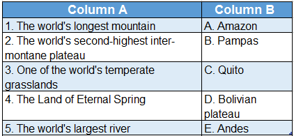
Answer: 1. E, 2. D, 3. B, 4. C, 5. A

2.WBBSE Solutions For Class 8 Geography Chapter 10 Topic A General Introduction And Physical Environment Of South America Match the Cloumns.

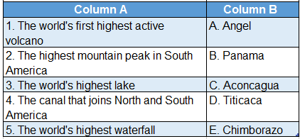
Answer: 1. E, 2. C, 3. D, 4. B, 5. A

Chapter 10 Topic A General Introduction And Physical Environment Of South America Write True Or False

Question 1. The world’s longest river is the Amazon.
Answer: False

Question 2. The system of shifting cultivation is prevalent in many regions of the Amazon rainforest.
Answer: True

Class 8 Geography Solution WBBSE

Question 3. The Pacific Ocean lies to the west of South America.
Answer: True

Question 4. The highest mountain peak in South America is the Drakensberg.
Answer: False

Question 5. The tropical grassland in the western part of the Brazilian Highlands is called Mato Grosso.
Answer: False

Question 6. The Galapagos Islands are located near the west coast of South America.
Answer: True

Question 7. Cape Horn is in the southern margin of South America.
Answer: True

Question 8. Most of the region of South America experiences when India’s summer experiences winter.
Answer: True

Question 9. The Atacama in Chile is a type of temperate desert.
Answer: False

Question 10. Aconcagua, the highest peak of the Andes mountain range.
Answer: True

Question 11. Angel Falls, on the Amazon River, is the world’s highest waterfall.
Answer: False

Question 12. The Amazon River transports 209000 cubic metre of water per second.
Answer: True

Question 13. Campos in Brazil is in the plateau region of Mato Grosso.
Answer: True

Question 14. The Bolivian Plateau is the highest plateau in South America.
Answer: True

Question 15. The estuary of the Paraguay river is known as the Rio de-la-Plata.
Answer: False

Question 16. At present, South America consists of 13 countries.
Answer: True

Question 17. Mount Chimborazo and Cotopaxi are the two active volcanoes of South America.
Answer: True

Question 18. The Inca civilisation flourished in ancient Peru.
Answer: True

Question 19. No delta has formed at the mouth of the Amazon River.
Answer: True

Question 20. The literal meaning of ‘Amazon’ is female warriors.
Answer: True

Question 21. Iguazu Falls are the waterfalls of the river Parana.
Answer: True

Answer In One Or Two Words

Question 1. What is the other name for South America, based on the languages spoken there?
Answer: Latin America.

Question 2. Which river is considered as the headwater course of the Amazon River?
Answer: Apurimac.

Question 3. Which country is nicknamed as the ‘Coffee Pot of the World”?
Answer: Brazil.

Question 4. Which is the largest city on the Amazon River basin?
Answer: Manaus.

Class 8 Geography Solution WBBSE

Question 5. Which is the highest natural lake in South America?
Answer: Titicaca.

Question 6. What is the capital of Venezuela?
Answer: Caracas.

Question 7. Name two countries in South America where fishing is well-developed.
Answer: Peru, Chile.

Leave a Comment