WBBSE Chapter 6 Hazards And Disasters Long Answer Questions
Question 1. What is meant by hazard and disaster?
Answer:
Hazard And Disaster:-
A dangerous condition or event that threatens or has the potential to cause injury to life or damage to property or the environment is known as a hazard. Hazards can be classified into two broad categories-natural and man-made.
Read and Learn Also WBBSE Solutions for Class 9 Geography And Environment
A disaster is an event or series of events that result in casualties and damage or loss of property, environment and livelihood on such a scale that is beyond the normal capacity of the affected community to sustain. A landslide that occurs on a hill slope can be termed a hazard. But when this same landslide causes casualties and damage to life and property on the slope, it becomes a disaster.
Question 2 What are the characteristics of hazard?
Answer:
The characteristics of hazard are as follows-
1. Most of the hazards are difficult to predict and occur all of a sudden.
2. Hazards may be nature-induced, human-induced or even a combination of both.
3. The expansion of hazard is generally over smaller areas and its magnitude is comparatively low.
4. Hazards have the potential to cause injury to life or damage to property or the environment.
5. Hazards with higher potential lead to disasters.
Question 3 Discuss the main characteristics of a disaster.
Answer:
The main characteristics of a disaster are as follows-
1. Distressed normal life: Normal public lives and activities are hampered and disrupted because of a disaster.
2. Casualties: A large number of human and animal life are devastated by a disaster. Damages and loss of property also take place.
3. Magnitude: The magnitude of a disaster is not always the same. They vary from intense to moderate.
4. Speed of occurrence: Disasters can be slow and predictable, or they may even be sudden and temporary.
5. Affects the environment: The negative environmental effects of disasters are by and large severe and persist for a long.
6. Dysfunctioning of essential services: The functioning of essential services such as transport and communication gets disrupted.
7. Combined effect of several factors: A disaster is a combination of hazard, vulnerability and insufficient capacity or measures to reduce the potential chances of risk.

Question 4 Explain and classify hazards.
Answer:
Hazards:-
A dangerous condition or event that threatens or has the potential for causing injury to life or damage to property or the environment is known as a hazard. Hazards can be classified into the following types-
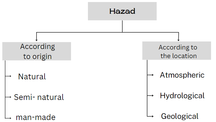
The following broad categories of hazards are discussed below-
1. Natural hazard: Natural hazards characterise those elements of the physical environment that are detrimental to human beings and are caused by forces extraneous to them. More precisely, the term ‘natural hazard’ refers to all atmospheric, hydrological and geological phenomena that, because of their location, intensity and frequency have the potential to affect adversely humans. beings, their constructions or their activities.
2. Semi-natural hazard: Hazards that are caused by the combination of natural and man-induced processes are known as semi-natural hazards. For instance, a landslide is a semi-natural hazard as it can be caused by natural processes (such as heavy or prolonged rainfall, earthquakes, volcanic eruptions, and slope undercutting by rivers) and can also be caused by human activities (such as slope excavation and loading, land use changes, irrigation, blasting vibrations, water leakage from utilities and such. others).
3. Man-made hazard: Man-made hazards are caused by elements like unscientific human activity, negligence or error, superstition or the failure of a man-made system. Man-made hazards can be controlled by increasing awareness among communities. According to the location, hazards can be classified into the following-
1. Atmospheric hazard: These hazards have their root in the atmosphere. For example, cloudbursts, cyclones and others.
2. Hydrological hazard: These hazards have their root in the water bodies. For example, floods, tsunamis and others.
3. Geological hazard: These hazards have their root in the interior of the Earth. Landslides, earthquakes and others are examples of geological hazards.
WBBSE Class 9 Geography Chapter 6 Hazards And Disasters Solutions
Question 5 What is meant by natural hazard? Give example.
Answer:
Natural Hazard:-
A hazard that is typically caused by nature and there is no human intervention is called a natural hazard.
Characteristics:
1. The main characteristics of a natural hazard are
2. It is only caused by nature. This type of hazard is entirely unmodified by human activities.
Effects: Natural hazards temporarily disrupt normal human life. It may also damage the property, environment and human life.
Examples: earthquakes, volcanism, cyclones, landslides, etc.
Question 6 What is meant by semi-natural hazard? Give example.
Answer:
Semi-Natural Hazard:-
A hazard caused by the combined effects of natural and man-induced processes is known as a semi-natural hazard.
Characteristics:
1. The main characteristics of semi-natural hazards are- Semi-natural hazards are caused by combined effects of nature and man.
2. These hazards occur due to improper uses of man’s knowledge and technology.
Effect: Sometimes this type of hazard causes disaster for its severity.
Example: Flood that occurs due to sudden release of water from reservoirs within a short period of time. Every flood is a natural hazard but the level of damage caused by the hazard is further increased by the intervention of man. Both the role of man and nature are important for occurrence of this type of hazard.
Question 7 What is meant by a man-induced hazard? Give example.
Answer:
Man-Induced Hazard:-
A hazard caused by the influence of ignorance, unconsciousness, superstitions, unscientific thinking, violence, etc. is known as a man-induced hazard.
Characteristics:
1. The main characteristics of man-induced hazards are- There is no role of natural force for these hazards.
2. Small self-interests and unconscious activities of humans are the main causes of these hazards.
Effect: This kind of hazard lags behind the social system and temporarily disrupts livelihood.
Example: Earthquakes that occur due to experimental explosions of atomic bombs, communal riots, etc.
Question 8 Discuss the causes of man-induced hazards.
Answer:
Causes Of Man-Induced Hazards:-
The hazards that are caused by elements like human intent, negligence, unscientific activities, superstition or failure of a man-made system are known as man-induced hazards. The notable causes of man-induced hazards are as follows-
1. Unscientific activities: Faulty and unscientific activities often lead to man-induced hazards. For instance, unplanned construction of houses on the hill slopes, faulty farming on the hill slopes or even carving roads across the slopes of hills intensifies the probability of landslides.
2. Illiteracy: Illiteracy leads to a lack of knowledge, intolerance and even negligence. All these lead to common man-induced hazards like arson, civil disorder and even terrorist activities.
3. Ungoverned population growth: Ungoverned population growth can lead to competition for scarce resources and susceptibility to diseases, that in turn, may cause civil strife and even loss of human life. 4. Riot: Ethnic conflict or communal riot causes hazards due to superstition, bigotry etc. It damages human life and property which disrupts social and economic life.
Understanding Hazards And Disasters In Class 9 Geography WBBSE
Question 9 Explain the various types of natural disasters.
Answer:
Various Types Of Natural Disasters:-
A natural event or a series of natural events that results in casualties and damages, is known as a natural disaster. They can be classified as follows-
1. Geophysical disaster: Disasters that are caused due to tectonic disturbances are called geophysical disasters. Earthquakes and volcanisms are examples of geophysical disasters.
2. Landform-process-related disaster: Landform processes like riverbank erosion, landslides in mountainous areas, coastal erosion due to sea waves, etc., may give rise to disasters if they occur on a macro-scale.
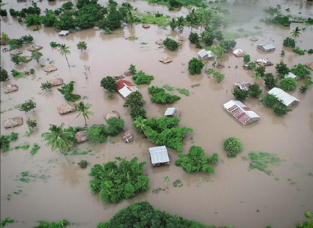
3. Meteorological/Climatic disaster: Disas- terms that are caused by extreme weather events are known as meteorological disasters. Storms, tropical cyclones, heat or cold waves, floods and droughts are examples of meteorological disasters.
4. Extraterrestrial disaster: Disasters that are caused by asteroids, meteoroids, comets and other extra-terrestrial elements striking the Earth are called extra-terrestrial disasters.
Example: Meteorite strikes.
5. Soil disaster: Various causes like soil erosion, an increase in salinity of soil and loss of fertility are the reasons for soil disaster. Excessive salinity of the soil hampers productivity and results in scarcity of food.
Example: This type of disaster frequently occurs in Rajasthan.
Economic disaster: An economic disaster is the widespread disruption or collapse of a national or regional economy, possibly causing financial loss, hoarding, famine, inflation, etc.
Question 10 Explain the various types of man- swKv induced or man-made disasters.
Answer:
Various Types Of Man- SwKv Induced Or Man-Made Disasters:-
An event or series of events that results in casualties and damages by man-induced causes is known as a man-induced disaster.
They can be classified as follows—
1. Technology-related disaster: A techno¬logy-related disaster is the failure of modern systems, like, unchecked exhaust fumes from vehicles, untreated wastes from industries, and leakage of radioactive minerals from nuclear. power plants, etc., which harms people and also pollutes the environment.
2. Economic disaster: An economic disaster is the widespread disruption or collapse of a national or regional economy, possibly causing financial loss, hoarding, famine, inflation, etc.
3. Biological disaster: Disasters caused due to the exposure of human beings to toxins, and viruses leading to epidemics, are known as biological disasters. Extinction of any species is also possible.
4. Disasters due to other complex emergencies: These involve a breakdown of administration, riots, religious conflicts, war, etc.
Question 11 What are the differences between hazard and disaster?
Answer:
The differences between natural hazards and disasters are as follows—
| Point of difference | Hazard | Disaster |
| 1. Concept | A dangerous condition or event that threatens or has the potential for causing injury to life or damage to property or the environment is known as a hazard. | A disaster is an event or series of events that results in casualties and damage or loss of property, infrastructure, environment, essential services or means of livelihood on such a scale that is beyond the normal capacity of the affected community to sustain. |
| 2. Extent | The extent of the impact is limited to a smaller region. | The extent of impact runs to a comparatively larger area. |
| 3. Nature | Hazards lead to disaster. | Disasters are impacts of hazards. |
| 4. Casualty | Hazards have the potential for causing injury to life, but may not always be fatal. | Disasters result in casualties. |
| 5. Economic damages | — Accounts for damage or loss of property that is lesser in comparison to disasters. | Accounts for damage or loss of property that is at a scale which is beyond the normal capacity of the area to sustain. |
| 6. Sub-types | Hazards can be classified into three broad categories—natural, semi-natural and man-made. | Disasters can be classified into two broad categories—natural disasters and man-made disasters. |
| 7. Control | Hazards are manageable and precautions can be taken to a certain level. | Disasters are unmanageable and precautions cannot be taken most of the time. |
Question 12 What are the differences between natural hazards and man-made hazards?
Answer:
The differences between natural and man-made hazards are as follows—
| Point of difference | Natural hazard | Man-made hazard |
| 1. Concept | Natural hazards characterise those elements of the physical environment that are detrimental to human beings and are caused by forces extraneous to us. | Man-made hazards are caused by an element of human intent, negligence or error or involving a failure of a manmade system. |
| 2. Extent | It has a widespread impact. | The extent of the impact is lesser, the nuclear explosion being an exception. |
| 3. Control | Natural hazards cannot be resisted or controlled but precautions can be taken. | Man-made hazards can be controlled by increasing awareness among communities. |
Question 13 What is meant by flash flood? What are the main causes of the occurrence of flash floods?
Answer:
Flash Flood:-
A flash flood can develop within a few hours of heavy rainfall. Flash floods can be highly dangerous and have the potential to instantly turn a gasping rivulet into a thundering channel of water that sweeps away everything in its path. Most of the casualties from flooding occur due to flash floods. The intensity of flash floods cannot be classified.
The causes of flash floods can be classified into two categories. They are—
1. Natural causes of flash floods: The natural causes of flash floods are—
1. Rapid rain: A flash flood may occur when it rains rapidly on saturated soil or dry soil with poor absorption ability. The run-off collects in gullies and streams and as they join to form larger volumes, it often exceeds the carrying capacity of the stream. This may lead to the occurrence of flash floods.
2. Volcanic eruption: A flash flood may also occur in areas on or near volcanoes, when glaciers may have been melted by the intense heat after eruptions.
3. Thunderstorms: Multiple or slow-moving thunderstorms occurring over the same area can also produce a flash flood.
4. Cloud burst: Cloud bursts result in excessive rainfall in a short time which can produce flash floods.
2. Man-induced causes of flash floods: Dam failure is extremely destructive and can create a flash flood. In such an event, the energy of the water stored behind even a small dam is capable of causing loss and damage to life and property in the downstream areas of the dam.
Class 9 Geography WBBSE Chapter 6 Hazards And Disasters
Question 14 What are the natural causes of floods?
Answer:
The natural causes of flood are as follows—
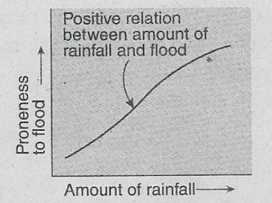
1. Excessive rainfall: Excessive rainfall occurring over a prolonged time causes a flood. Due to this excessive rainfall, the discharge of a river exceeds the capacity of its channel to carry it. Thus the river overflows its banks causing a flood. Therefore, excessive rainfall is positively related to flood.
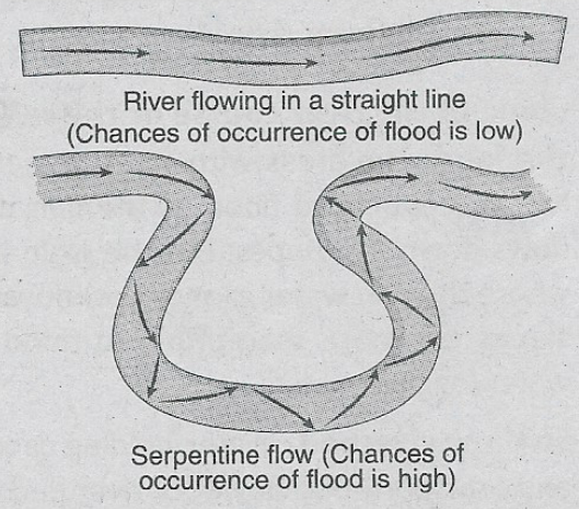
2. The shape of a river course: The probability of flood increases if the course of a river is meandering rather than straight since the flow of the river is hindered by obstacles along its course and hence overflowing occurs.
3. Snowmelt: During the warm summers, the glacial snow in the mountains melts down. This results in the flow of a large amount of water downslope within a short period of time. As the ground is almost frozen, water cannot penetrate or be absorbed. The water, therefore, flows off the surface and runs into lakes, streams and rivers. This causes excess water to spill over the respective banks and results in snow-melt floods.
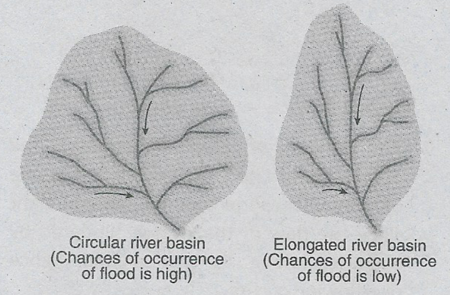
4. Shape of the drainage basin: The possibility of flash flood increases in a drainage basin that is circular in shape rather than the elongated one. This is because, in the latter case, rivers have the capacity to carry water over long distances.
5. Slope of the river course or the relief of the land: The areas with steep slopes are less susceptible to flood as rainwater flows down the slopes. But the plain lands where the rainwater cannot flow down the slopes are more susceptible to flood and waterlogging.
6. Shallow riverbed: Water holding capacity and transportation power of the river decrease due to the sediment action on the riverbed over a long time which makes the riverbed shallow. As a result, normal rainfall causes floods in the river.
7. Cyclonic storm and intensity of tide: Spate and flood may occur in coastal regions due to cyclonic storms. Similarly, at the time of a new moon and full moon the excess water that enters the river from the sea, causes a flood.
Question 15 Briefly describe the causes of man-made floods.
Answer:
The main causes of man-made floods are—
1. Deforestation: Vegetation cover prevents soil erosion and also controls the amount of precipitation.
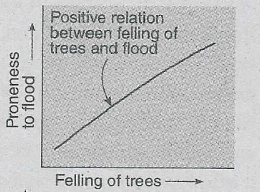
Deforestation increases soil erosion and the sedimentation of the eroded materials on the riverbed over a long period of time makes the riverbed shallow. As a result, the possibility of the occurrence of flooding increases.
2. Modification of the catchment area: The land-use pattern of the catchment area changes with the increasing number of settlements, urbanisation, industrialisation and the change in agricultural patterns. All these may subsequently lead to flooding.
3. Change in the course of the river: Artificial modification in the course of a river such as the construction of dams, development of irrigation systems and such others to satisfy human needs may also lead to flooding in the long run.
Question 16 Explain the negative impacts of floods.
Answer:
The various negative impacts of the flood are as follows—
1. Impacts on physical nature: The impacts of the flood on physical nature are—
1. Floods can cause water pollution,
2. it disrupts the environmental balance,
3. It can cause soil pollution.
2. Impacts on the ecosystem: The impacts of the flood on the ecosystem are—
1. Flood destroys the standing crops and other small vegetation covers,
2. It disrupts the food chain,
3. It causes inadequacy of food for herbivores,
4. a large number of animals and birds may die due to floods.
4. Impacts on the human: The impacts of the flood on the human being—
1. It hampers agricultural activities,
2. It causes loss of life and damage to property,
3. flood results in water-borne diseases (such as Cholera and Typhoid),
4. It disrupts public life by destroying settlements, communication and transport systems.
Question 17 Differentiate between flood caused by snow melt water and flood caused by rain
Answer:
The differences between floods caused by snow melt water and flood caused by rain are as follows—
| Point of difference | The flood caused by snow melt water | The flood caused by rain |
| 1. Extent | The flood caused by the melting of snow extends over a larger area. | The flood caused by heavy rainfall extends over a lesser stretch of area. |
| 2. Region | It occurs mostly in the downstream areas of the hill slopes. | It occurs in the plains, mostly near the river banks. |
| 3. Season | It mostly occurs in summer. | It mostly occurs during the monsoon season. |
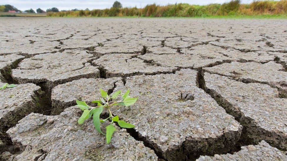
Question 18 Discuss the causes of droughts.
Answer:
Causes Of Droughts:-
The causes of droughts can be classified into two categories.
They are—
1. Natural causes of drought:
The important natural causes of drought are—
1. Temperature rise: A rise in land and sea surface temperature increases evaporation leading to droughts.
2. Change in atmospheric circulation: Atmospheric circulation patterns influence the moisture content of the atmosphere. Reduction in atmospheric moisture due to the change of these circulation patterns reduces the average precipitation, which causes droughts.
3. Lack of soil moisture: Soil moisture content can also, influence the occurrence of drought. If the soil is dry, then there is little or no water available to evaporate. Consequently, the incoming sunlight can only continue to warm the surface, thereby making conditions hotter and drier, thus beginning the chain of events leading towards drought.
2. Man-induced causes of drought:
The main-induced causes of drought are—
1. Reckless deforestation: Reckless deforestation that leads to a decrease in atmospheric as well as soil moisture, increases the probability of drought.
2. Unplanned urbanisation: Unplanned urbanisation that restricts the replenish¬ment of groundwater level and subsequently puts pressure on water resources, may cause drought conditions.
Question 19 Classify and discuss the various types of drought based on water availability.
Answer:
Various Types Of Drought based on Water Availability:-
Based on water availability, droughts can be classified into three categories—
1. Meteorological drought: A drought is categorised as a meteorological drought when actual rainfall over an area is significantly less than the normal amount of rainfall. Meteorological droughts need to be defined specifically in particular regions as the atmospheric conditions that result in deficiencies of precipitation vary highly from region to region. Meteorological drought can also be defined as the actual precipitation departures from average amounts on monthly, seasonal or annual time scales.
Drought can be classified into the following sub-types—
1. Mild drought: When rainfall is 11% to 25% less than normal rainfall.
2. Moderate drought: When rainfall is 26% to 50% less than normal rainfall.
3. Severe drought: When rainfall is less than 50% of the normal rainfall.
2. Hydrological drought: A hydrological drought occurs when there is a marked depletion of surface water causing very low stream flow and drying of lakes, reservoirs and rivers. Therefore, hydrological drought is related to periods of precipitation deficits in the surface or subsurface water supply.
It can again be classified into two types—
1. Surface water drought: This is caused when ponds, lakes and rivers dry up due to inadequate rainfall.
2. Groundwater drought: When the level of groundwater decreases due to a deficit of rainfall, groundwater drought occurs.
3. Agricultural drought: An agricultural drought occurs when inadequate soil moisture produces acute crop stress and affects productivity in the long run. Inadequate topsoil moisture during the planting stage may obstruct germination, leading to low plant populations per hectare and a reduction of final yield. However, if topsoil moisture is sufficient for early growth, insufficiencies in subsoil moisture at this early stage may not impact final yield if subsoil moisture is replenished as the growing season progresses or if precipitation meets plant water needs.
Question 20 Classify drought on the basis of the time period.
Answer:
Classification Of Droughts On The Basis Of The Time Period:-
Droughts differ in the time and period of their occurrence. Thornthwaite delineated drought as follows—
1. Permanent drought: It occurs mostly in arid desert regions. Crop production is not possible without irrigation, due to inadequate rainfall. In these areas, the xerophyte type of vegetation is generally observed. For example, cacti, thorny shrubs, etc.
2. Seasonal drought: It occurs in areas with clearly defined wet and dry climates. Seasonal drought occurs due to large-scale seasonal circulation. This occurs mainly in monsoon areas.
3. Contingent drought: This results due to irregular and variable rainfall, especially in humid and sub-humid regions. The occurrence of such droughts may coincide with growth periods of the crops when the water needs are critical and the greatest, resulting in the severity of the effects i.e., yield reduction.
Question 21 Briefly discuss the impacts of drought.
Answer:
Droughts create immense environmental and socio-economic impacts. The impacts are as follows-
1. Impact on the environment:
1. The ecological balance is disturbed due to enhanced soil erosion (due to loss of soil moisture).
2. The fertility of soil decreases.
3. Loss or destruction of vegetation cover may lead to desertification of the region.
4. Spread of diseases in wild animals and migration of wildlife may be observed because of reduced food and water supplies.
2. Impact on the ecosystem:
1. It causes damage to plants and animals.
2. plants struggle to survive due to the hampering of the process of photosynthesis.
3. Food scarcity is noticed for the herbivorous animals that lead to the death of a vast number
4. Impact on the population:
1. Lack of precipitation may subsequently lead to lesser replenishment of groundwater and as a result, the groundwater level falls. This makes irrigation more difficult and many farmers become jobless.
2. Excessive drought conditions may lead to famine and starvation becomes a common picture.
3. Many people die due to a lack of nutrition and tremendous heat.
4. Droughts lead to international and intra-national migration.
Question 22 Briefly explain the causes of drought in India.
Answer:
The main causes of drought in India are—
1. Natural causes:
1. India is a monsoon-dominated country. So, if the southwest monsoon wind arrives late than its normal arrival time, then it creates a drought condition.
2. Break in monsoon or a persisting long dry period within the monsoon season causes drought.
3. If the monsoon winds retreat before the normal time, drought conditions prevail.
4. Each state of India does not receive an equal amount of precipitation during monsoons. This areal difference in precipitation may cause drought.
5. In El Nino years, the normal patterns of precipitation and atmospheric circulation get disrupted. This is also an important reason for drought in India.,
2. Man-induced causes:
1. The amount of water vapour in the atmosphere decreases due to excessive deforestation, causing a lack of sufficient precipitation and eventually drought.
2. Some other man-induced causes of drought in India are urbanisation, industrialisation, pollution, etc.
Question 23 Differentiate between meteorological drought and agricultural drought.
Answer:
The differences between meteorological and agricultural drought are as follows—
| Point of difference | Meteorological drought | Agricultural drought |
| 1. Concept | Meteorological drought occurs when actual rainfall over an area is significantly less than the climatological mean. | Agricultural drought occurs when inadequate soil moisture produces acute crop stress and affects productivity. |
| 2. Dependency | It is not dependent on agricultural drought. | It is dependent on meteorological drought. |
| 3. Impact | It has a widespread impact. | The extent of the impact is lesser than meteorological drought. |
Question 24 Write three differences between meteorological and hydrological drought.
Answer:
The difference between meteorological and hydrological drought is as follows-
| Point of difference | Meteorological drought | Hydrological drought |
| 1. Concept | Meteorological drought occurs when actual rainfall is less than normal rainfall and causes dry weather conditions. | Hydrological drought occurs when inadequate soil moisture produces acute crop stress and affects productivity. |
| 2. Dependency | It is dependent on the atmospheric temperature and the amount of rainfall. | It is dependent on the amount of groundwater. |
| 3. Cause | This kind of drought occurs due to inadequate rainfall. | This kind of drought occurs due to the water shortage in the river basin. |
Question 25 What are the impacts of earthquakes?
Answer:
The impacts of earthquakes can be devastating. Some of the most commonly observed impacts of earthquakes are as follows—
1. People may be killed or injured.
2. Built landscapes such as houses may be ‘ destroyed.
3. Transport and communication links may be interrupted and shops and businesses may be destroyed. This can subsequently lead to difficulty in trade.
4. Water pipes may burst and water supplies may be contaminated.
5. Fires can spread due to gas pipe explosions that can even lead to forest fires in certain areas.
6. Landslides may occur.
7. Tsunamis may cause flooding in coastal areas.
8. Can lead to social unrest and heedless looting may take place.
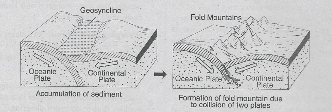
Question 26 Explain why the Himalayan regions are prone to earthquakes.
Answer:
The Himalayan Regions Are Prone To Earthquakes:-
The Himalayan mountain range was formed due to the collision of Indian and Eurasian plates – a process that began at least 50 million years ago. Where the two plates converge, the Indian plate plunges below the Eurasian. The two plates continue to rub against each other due to the northward movement of the Indian plate-this continuously generates immense geological stress. This builds up pressure, leads to seismic vulnerability and is later released as earthquakes.
The east-west lying fault line that separates these two plates is known as the Main Himalayan Thrust (MHT). Since there is no historical evidence of earthquakes iri several portions of the Himalayan arc, it is predicted that there is potential energy available to generate large earthquakes.
Question 27 Briefly discuss the natural causes of the Earthquake.
Answer:
The natural causes of the earthquake are as follows—
1. Plate tectonics: Due to prevailing high temperature and pressure, convection currents evolve in the viscous mantle below the earth’s crust. These convection currents cause the plates (parts of the earth’s crust) to move in different directions and at different speeds from those of the adjacent ones which at times cause earthquakes.
2. Isostatic causes: Isostasy is the state of gravitational equilibrium between the Earth’s lithosphere and asthenosphere and in this process of trying to attain a hydrodynamic equilibrium, earthquakes may take place.
3. Formation of fold mountains: Formation of new fold mountains may also result in the occurrence of earthquakes.
4. Volcanism: Volcanic activity may also cause earthquakes.
5. Landslides and avalanches: During landslides and avalanches a huge mass of snow, ice and rocks slide down along the steep slopes of mountains/that may cause earthquakes.
6. Meteorite: Meteorite impacts could cause larger earthquakes than has ever been observed. A Meteor crater in Arizona in the United States is an example.
7. Collapse of subterranean cavities: The removal of minerals and other materials from the Earth may cause instability, leading to the sudden collapse of subterranean cavities, which may cause local tremors. In karst areas, due to the action of underground water, the sudden collapse of the ground surface also causes an earthquake.
Question 28 Briefly explain the anthropogenic causes of earthquakes.
Answer:
Anthropogenic Causes Of Earthquakes:-
Unplanned anthropogenic activities may lead to earthquakes.
For example—
1. Faulty construction of dams: It is well-accepted that large dams can cause earthquakes. Dams cause earthquakes due to the extra pressure of water created in the minor cracks and fissures in the ground under and near a reservoir.
2. Nuclear testing: Nuclear testing may also trigger earthquakes. As an example, in 1999, an earthquake occurred due to the explosion of nuclear testing at Pokhran in Rajasthan.
3. Dynamite blasting for road construction: Blasting of rocks by dynamite for the construction of roads may trigger earthquakes.
4. Collapsed roof of the mines: Earthquakes can occur locally due to the collapsing of the roof of the mines if the pit mines are not perfectly filled with sand. This kind of earthquake often occurs at Ranigange.
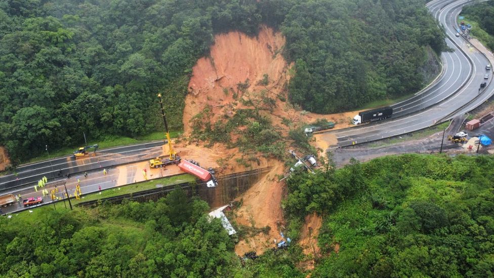
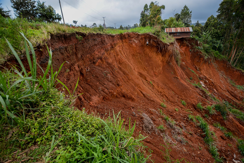
Question 29 ‘Mountainous regions are prone to landslides.’ Why?
Answer:
Mountainous Regions Are Prone To Landslides:-
Landslides are mainly associated with mountainous regions. This is because of the following reasons—
1. Geological causes: Weak or sensitive materials of the hill-slopes and the abundance of weathered materials make the mountainous regions prone to landslides.
2. Climatic causes: Mountainous regions are inclined to freeze-thaw cycles and wetter conditions promote organic activity and associated weathering. Soil slopes and rocks are weakened through saturation by heavy rain or snow melt. Moreover, winter snowstorms may produce avalanche-like conditions. All these together cause a landslide-prone condition.
3. Human causes: Landslides are frequently caused by the undercutting of slopes during road construction or when fill materials are dumped onto already less stable slopes. Defectively constructed mine tailing piles, dams and waste landfills may result in landslides. Construction of houses on hill- slopes and reckless deforestation are the most commonly observed causes of landslides in the hills.
Question 30 Briefly discuss the natural causes of landslides.
Answer:
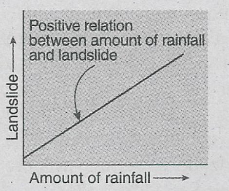
The natural causes of landslides are as follows—
1. Intense and prolonged rainfall: Prolonged and intense rainfall is the immediate and direct cause of landslides where water acts as a lubricant. With prolonged and intense rainfall large amounts of rainwater seep into the soil that results in an increase in water pressure in the pores of the soil. Thus the friction and internal cohesion of slope materials reduce, which subsequently destabilises the slopes and causes landslides.
2. Earthquake: Earthquakes can trigger landslides in the hill slopes if the magnitude reaches 6 and above.
3. Slope gradient: Slopes with steeper gradients are more prone to landslides as gravity has more influence on these slopes, increasing their sliding force.
4. Loose materials: Unstable materials like large boulders increase the vulnerability of the slope which leads to landslides.
5. Topography: Any cracked or faulted topography is weaker than any other type of topography, which causes landslides.
6. Nature of soil: The predominance of pebbles and sand makes the soil loose, which causes landslides.
Question 31 Briefly discuss man-induced causes of landslides.
Answer:
The man-induced causes of landslides are as follows—
1. Deforestation: Large-scale deforestation can make a place vulnerable to landslides. The roots of the trees hold the soil in place. But excessive deforestation in hilly regions makes the soil loose. As a result, the regions become landslide prone.
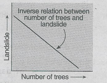
2. Urbanization: Unscientific construction of roads and houses on steep slopes disturbs soil stability, which may lead to landslides.
3. Shifting cultivation: Shifting cultivation is an unsustainable practice that depletes the soil nutrients and reduces the forest cover, causing landslides.
4. Overgrazing: Overgrazing may result in land degradation that may subsequently lead to landslides.
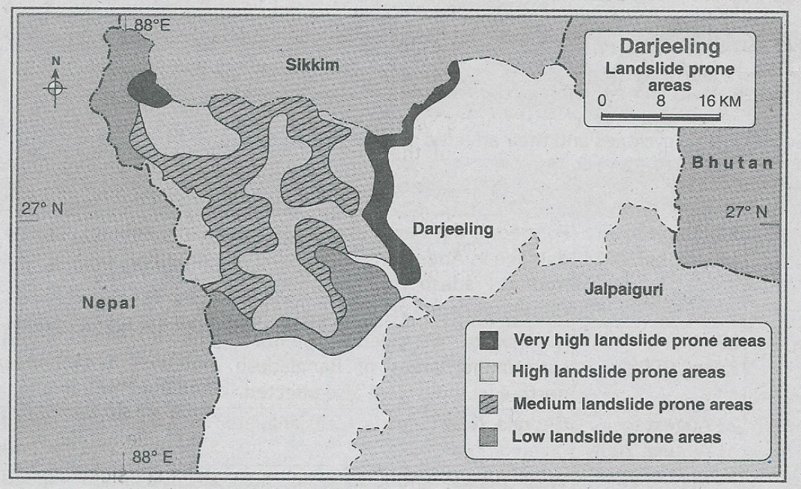
For example, Darjeeling district is one of the most landslide-prone districts of West Bengal. The Paglajhora region is highly prone to landslides due to both natural factors and increasing human activities for the last five decades.
Question 32 Briefly discuss the impacts of a cyclone.
Answer:
The impacts of a cyclone are—
1. Impact on the physical environment:
1. Disturbs the balance of the ecosystem: Vast number of animals and birds die due to the occurrence of a cyclone that subsequently leads to the imbalance of the local ecosystem.
2. Occurrence of the flood: Heavy rainfall may accompany a cyclone, which may lead to a devastating flood.
3. Coastal erosion: The strong waves formed by a cyclone near the coast may result in coastal erosion.
2. Impact on human beings:
1. Loss of life: Huge loss of human and animal life occurs due to cyclones. Vast areas of vegetation cover are also destroyed due to cyclones.
2. Loss of property: Cyclones disrupt communication and transport systems. They ravage and inundate the agricultural fields and subsequently may cause food scarcity. They also hamper public life by destroying houses.
3. Spread of epidemics: The water gets polluted due to cyclones, resulting in water-borne diseases. Epidemics like Cholera may spread from this polluted water.
Question 33 Write about some terrible cyclones and their affected areas.
Answer:
Some terrible cyclones and their affected areas are-
| Cyclone | Time of occurrence | Affected areas | Speed of cyclone |
| 1. Hudhud | 7 October to 14 October 2014 | Formed in the Bay of Bengal and caused damage in Andaman and Nicobar island, Andhra Pradesh Visakhapatnam, Odisha, Chhattisgarh and also in Madhya Pradesh, | Maximum speed was about 260km/hour. |
| 2. Nargis | 27 April to 3 May 2008 | It mainly damaged Myanmar but surrounding areas of Bangladesh and north-east India were also affected. | Maximum speed was about 165-215 km/hour. |
| 3. Katrina | 23 August to 31 August 2005 | Georgia, New Orleans, Louisiana, etc. | Maximum speed was about 200 km/hour |
| 4. Aila | 25 May to 27 May 2009 | West Bengal and Odisha in India and Bangladesh. | Maximum speed was about 110-120 km/hour. |
Question 34 What are the causes for the origination of a tsunami?
Answer:
The major causes of tsunamis are—
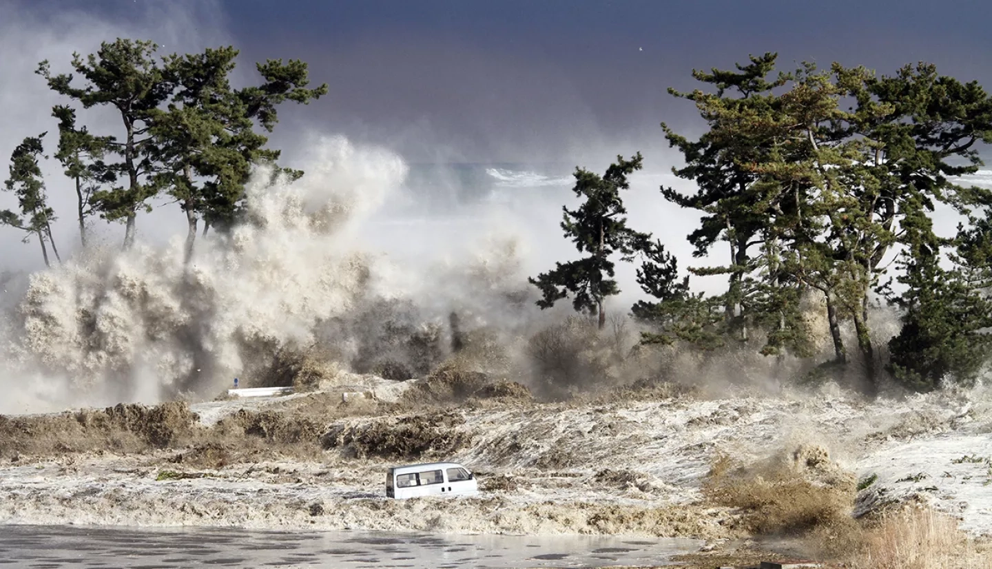
1. Submarine earthquake: Most severe earthquakes occur in convergent boundaries where an ocean plate slides under a continental plate. All earthquakes do not generate tsunamis. To generate a- tsunami, the fault where the earthquake occurs must be underneath or near the ocean. It must also cause vertical movement of the sea floor over a large area. Earthquakes originating at shallow depths of the seabed (focus) are responsible for the most destructive tsunamis.
2. Landslides: Landslides resulting in rockfalls, submarine landslides or slumps can generate tsunamis. For example, the movement of a significant amount of earth for the construction of an airport triggered an underwater landslide in 1980 in southern France. This resulted in a devastating tsunami hitting the harbour of Thebes.
3. Eruption of the volcano: Volcanic eruptions can generate waves as a result of sudden displacement of water giving rise to tsunamis. For example, one of the most devastating tsunamis was ever recorded on August 26, 1883, after the explosion and collapse of the Krakatoa in Indonesia.
4. Extraterrestrial collision: Although tsunamis caused by extra-terrestrial collisions such as meteors and asteroids- induced tsunamis have not been recorded in recent history and the possibilities are rare, tsunamis may be generated by such extra-terrestrial collisions.
Question 35 Briefly discuss the effects of tsunamis.
Answer:
The major effects of tsunamis are—
1. Physical changes: Tsunami may result in various physical changes. For example, the islands of Andaman and Nicobar experienced widespread devastation because of a tsunami in 2004. Some smaller islands in the Nicobars have entirely vanished and some others have changed shape, such as Trinket which has been split into two parts after the tsunami.
2. Change in soil characteristics: Tsunami may result in a change in the characteristics of soil, especially soil salinity. The coastal regions are bounded by vast expanses of salty, marine waters and thus the salinity of the soil may increase at certain times. This may negatively affect soil fertility and productivity.
3. Damages the marine ecosystem: Tsunamis cause great damage and even devastation to the marine ecosystem.
4. Shortening the length of the day: The massive earthquake that struck Sumatra in 2004 has shortened the length of the earth’s day. The intense tremor of 9.1 magnitudes has accelerated the spin of the earth, shortening the length of the 24 hours day by 6.8 microseconds.
5. Casualties: Tsunamis are generally very devastating and cause huge loss of life for humans and animals. The tsunami waves in the morning hours of December 26, 2004, around the Bay of Bengal caused an official death toll of 812 and the unofficial death toll is estimated to be about 7,000.
6. Damage to property: Tsunamis generally cause great damage to property, especially in coastal regions. Huge losses of houses, roads, agricultural fields, and factories are caused by tsunamis.
Question 36 Write a short note on the blizzard.
Answer:
A blizzard is a severe storm condition characterised by low temperatures, strong winds and heavy snow. Blizzards can restrict visibility to near zero. Blizzards have a negative impact on the local economy.
Characteristics: The main characteristics of blizzard are—
1. Strength of wind: Winds that are at least 56 kilometres per hour or greater than the normal snowstorm are identified as blizzards.
2. Visibility: The visibility is reduced to almost 400 metres or even to zero at times.
3. Duration: Most blizzards last for a duration almost 3 hours.
Location: The occurrence of blizzards is most prominent in the countries of Antarctica, northern parts of North America, Canada, north of Europe and Asia as well as in New South Wales in Australia. Apart from these, the snowcapped high mountainous regions also experience blizzards.
Question 37 Discuss with examples how a blizzard can cause hazards or disaster. Or, Briefly discuss the effects of blizzard.
Answer:
During blizzards, winds combined with fleeting snow produce extreme conditions and disrupt normal living conditions.
The hazards caused by blizzards are as follows—
1. Physical illness: The extreme cold winds during blizzards are a cause of great discomfort to the local people which may subsequently lead to physical illness and may even cause hypothermia. Such as, in 1972, four thousand people died due to the effect of a blizzard in Iran.
2. Disrupts transport system: The thick layers of snow that accumulate during blizzards may disrupt the local transport system. Blizzards paralyse the transport system and leave the roads in unsafe conditions. For example, from March 11 to 14, 1888, a blizzard dumped an average of 1 metre of snow over southeast New York and the southern part of New England. It killed over 400 people, of which New York City alone recorded 200 deaths.
3. Flood: The sudden rise in temperature that may follow a blizzard can prove to be damaging as the rapid snow-melt water may trigger serious floods and other fatal accidents.
4. Disrupts public life: Blizzards generally disrupt public life by interrupting transport, electricity and water supplies and also normal day-to-day life by interrupting health and educational facilities.
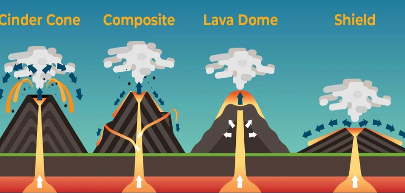
Question 38 Discuss briefly the causes of volcanism.
Answer:
The major causes of volcanism are as follows—
1. Plate tectonics: The earth’s crust is divided into a number of tectonic plates moving in different directions and at different speeds. At the convergent plate boundaries, the plates move towards each other, at the divergent plate boundaries the plates move away from each other and at the transform plate boundary, the plates slide past each other horizontally. These boundaries are geologically active and the movement of the plate gives rise to the occurrence of volcanoes.
2. The buoyancy of the magma: As a rock inside the earth melts, its volume increases,
producing magma that is less dense than the surrounding rock. This lighter magma rises up because of its buoyancy. Since the density of the magma between the zone of its generation and the surface is less than that of the surrounding and overlying rocks, the magma will reach the surface and erupt.
3. The pressure from the dissolved gases in the magma: Magma contains dissolved volatiles like water, sulphur dioxide and carbon dioxide. The amount of dissolved gases in the magma at atmospheric pressure is zero but rises with increasing pressure. When magma moves toward the surface, the solubility of the water in the magma decreases, and excess water separates from the magma as bubbles. The closer it gets to the surface, the more water comes from the magma, increasing the gas and magma ratio in the magma tube. When the volume of bubbles reaches about 75%, the magma turns into partially molten and solid fragments and it erupts explosively.
4. Injection of new magma into an already filled magma chamber: As an additional amount of magma enters a chamber that is already at its full capacity, the new magma causes some of the existing magma to move to the surface and erupt.
5. Release of energy: A volcanic event occurs when there is a sudden or continued release of energy caused by magma movement near the surface. The energy can be in the form of earthquakes, gas emission at the surface, release of heat through geothermal activity, explosive release of gases and the non-explosive extrusion or intrusion of magma.
Question 39 Briefly discuss the impacts of vulcanicity.
Answer:
The impacts of vulcanicity have been shown broadly—
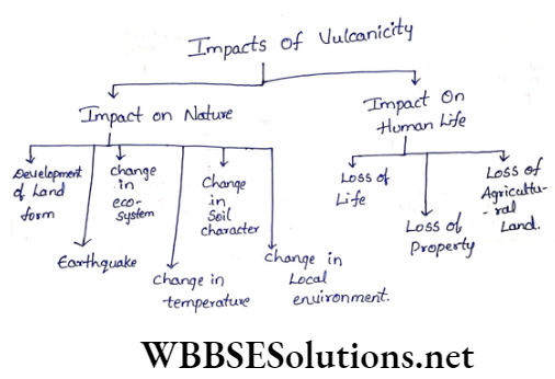
1. Impact on nature:
Vulcanicity impacts nature in various ways—
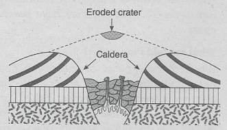
1. Development of landforms: Different types of landforms like caldera, cinder cones, laccolith, dykes, sills, etc., are formed due to vulcanicity.
2. Earthquakes: When explosions take place during volcanic eruptions on a massive scale, earthquakes may be felt in adjoining areas.
3. Change in the ecosystem: The ecological balance of the affected area is disturbed as many species of plants and animals become endangered.
4. Change in temperature: The temperature of the surrounding areas of a volcanic eruption increases.
5. Change in soil character: Soil characteristics get changed as lava spreads across the land.
6. Change in the local environment: Local environment is considerably changed. For example, there is a possibility of acid rain as a reaction to toxic gases released during vulcanicity.
2. Impact on human life: Vulcanicity also affects human life—
1. Loss of life: A massive loss of life occurs as a result of vulcanicity. For example, about 3600 people died in the coastal areas of Java when the Krakatoa volcano erupted in 1883.
2. Loss of property: Huge loss of properties like buildings, transport networks, and industries occurs and the economic life of the whole region is affected.
3. Loss of agricultural land: Large tracts of land are rendered infertile as a result of being covered by hot molten lava gushing out of the volcanoes. For example, the famous Barren Island of Andaman and Nicobar.
Question 40 Briefly discuss the causes of a forest fire.
Answer:
The main causes of forest fires are-
1. Natural causes:
The natural causes of forest fires are—
1. If lightning strikes, dry leaves of trees or tree trunks may get ignited.
2. In the dry season, a boulder coming down a mountain slope may give rise to a spark that leads to a fire.
3. A vol¬canic eruption may also cause a forest fire.
2. Man-made causes:
The man-made causes of forest fires are—
1. When a forest is burnt for clearing land for agricultural activities like in shifting cultivation, the fire may spread, causing a forest fire.
2. The fire used for cooking in tents by mountaineers may also cause forest fires.
3. If a lit cigarette is discarded by someone unmindfully on the forest floor, the dry leaves on the forest floor may cause a fire to break out.
Question 41 What are the effects of a forest fire?
Answer:
The effects of forest fires can be categorised into two sub-types. They are as follows—
1. Primary effects:
Primary effects of forest fires are—
1. Casualties and injury to people and animals who are caught in the flames.
2. Damages to property and possessions.
3. Burning of vegetation and crops.
4. Release of large amounts of smoke.
2. Secondary effects:
The secondary effects of forest fires are—
1. Health troubles for people as a result of the smoke and ash.
2. Loss of jobs for agricultural workers whose animals and crops get destroyed.
3. Diminution in the tourist industry, leading to loss of jobs and restriction to recreational areas.
4. Soil erosion and landslides because there is less vegetation to bind the soil together.
5. Loss of habitats for animals may lead to the extinction of some species.
Question 42 What remedial measures can be taken to prevent the occurrence of forest fires?
Answer:
The different measures that can be taken to prevent forest fires are—
1. Do not throw any inflammable object or lighted objects on the forest floor,
2. Remove dry leaves and parts of plants and trees to safe corners as much as possible,
3. Keep pets and other valuables at a safe distance
4. Dig a circular canal and make arrangements for adequate water around the zone of forest fire,
5. Act as per emergency instructions broadcast by radio or other devices during a forest fire,
6. Arrange awareness programmes for forest dwellers and people residing in forests regarding measures to save their lives.
Question 43 What are the favourable conditions that cause avalanches?
Answer:
The favourable conditions that cause avalanches are-
1. Slope of the land: It has been observed that avalanches are a common occurrence on slopes ranging from 35°-45° and concave slopes are more favourable than convex slopes of the mountain.
2. Excessive snowfall: Avalanches are influenced by the amount of snow or ice on the mountain tops. Excessive snowfall increases the possibility of avalanches.
3. Smoothness of slope: In comparison to forested or vegetated slopes, bare and smooth slopes act as a trigger for avalanches.
4. Size of ice crystals: Since bigger ice crystals are weak and break easily, they are more prone to initiate an avalanche compared to compacted or packed ice.
5. Sun rays: Since the sun’s rays warm up the ice, they lead to avalanches.
6. Wind flow: Winds blowing from varying directions loosen up the ice and initiate an avalanche.
7. Human interference: Human activities such as cutting down of trees, construction of roads, explosion by dynamite, ice sports etc., increase the possibility of avalanches.
8. Melting of the snow: Sun rays warm up the snow on the hill slope and thus the snow gradually melts. As a result, avalanches occur and melted snow moves down the slope.
9. Earthquake: Earthquake causes crack in the snow which results in avalanches.
Chapter 6 Hazards And Disasters Short Answer Questions
Question 1 Discuss the importance of disaster management.
Answer:
Importance Of Disaster Management:-
The main purpose of disaster management is to reduce losses in all spheres such as, social, economic, environmental etc.
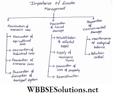
1. Prevention of economic loss:
1. Prevention of agricultural loss: The fertility of the land diminishes and the salinity of soil may also increase as a result of floods, droughts, earthquakes etc. Proper infrastructure can be developed for the cultivation of crops if a forecast of any disaster is made.
2. Prevention of industrial loss: Various industrial products and infrastructure are damaged which can be restored by undertaking proper disaster management programmes.
3. Prevention of economic loss: The economy of any region is hampered as a result of loss in agricultural and industrial, sectors due to natural calamities. Appropriate disaster management measures can be taken to reduce such economic losses.
4. Prevention of disruption of transport system: When the transport system is disrupted due to calamities like, landslides, earthquakes etc., alternative modes of transport can be arranged to alleviate the problem.
2. Prevention of social damage:
1. Rehabilitation of affected people: A damaged area can be restored to its original normal state by acting on an emergency basis and on a war footing.
For example—
Rapid action taken for rescuing people and rehabilitating them would be of immense help.
2. Supply of necessary items: Supply of necessary items like food, water, shelter, etc., is possible through aid by state and central governments.
1. Prevention of loss of property: If a warning is issued prior to the disaster, much of the damage caused to life and property can be minimised.
2. Reconstruction: Disaster management also helps to rebuild properties (like houses, buildings, etc., quickly that are damaged.
3. Prevention of environmental damage:
1. Maintenance of ecological balance: By adopting appropriate measures of disaster management, the damage incurred to the environment can be reversed.
2. Pollution control: Disaster management helps to control pollution.
For example—
Afforestation along the bank of a river helps to prevent the erosion of soil and the subsequent sedimentation of river beds. As a result, floods are prevented and eventually soil pollution is controlled. Besides that, planting trees help to control air pollution.
Question 2 Adoption of disaster management techniques can be used to reduce the after-effects of a disaster
Answer:
The occurrence of most natural disasters cannot be stopped but measures can be taken to reduce the after-effects. The organization and management of resources and responsibilities for dealing with all humanitarian aspects of emergencies, in particular, preparedness, response and recovery in order to lessen the impact of disasters is termed disaster management.
The procedures to be followed are as follows—
1. Preventive measures:
Even before the actual disaster occurs there are some prior measures that can be taken to reduce the intensity of the disaster. Such as-
1. Conducting awareness programmes,
2. Compiling suitable laws,
3. Conducting proper regional surveys and preparing maps,
4. Forecast of the disaster can be transmitted through radio and television channels to the common people.
2. Remedial measures:
These measures are taken once the disaster has hit a region. There are two stages of remedial measures—
1. The first stage involves the rescue and recovery of the affected people and providing them with relief facilities like food, medicine, clothing, temporary houses and others.
2. The second stage involves working towards recovery in order to lessen the impact of disasters and revert to normal conditions. The measures taken under this stage are re-establishing the communication systems, rebuilding the roads, houses, and schools and working towards the supply of electricity, and safe drinking water.
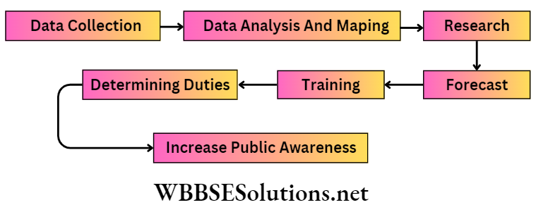
Question 3 What are the pre-disaster measures that should be taken?
Answer:
Pre-disaster measures that should be taken care of—
1. Data collection: Data related to causative factors of disasters should be collected.
For example—
In the case of floods and droughts, rainfall data for the past few years should be taken.
2. Data analysis and mapping: The collected data is then analysed to determine the intensity and extent of the disaster and mapping are done on the basis of analysed data.
3. Research: After mapping, thorough research is undertaken in order to assess past conditions and future predicaments.
4. Forecast: If a proper forecast is done through data analysis using modern technology, the amount of loss or damage caused by any disaster can be minimised.
5. Training: Training can be imparted to all including common people, army personnel etc., by the authorities at the centre, state and district levels so that the loss and damage incurred in a disaster are minimal.
6. Duty distribution: After proper training, duties and responsibilities are determined for all the people. It helps to prevent disaster and also helps to deal with it.
7. Increase public awareness: Steps should be taken to increase public awareness and precautionary measures should be taken.
Question 4 what measures are undertaken after a disaster?
Answer:
Measures that are disasters are-
1. Rescue operations: These are undertaken on an emergency basis by both the local people and army personnel in order to save a maximum number of people and animals.
2. Relief operations: Relief materials are distributed to the people of the affected area by central and state government ‘agencies and the extent of loss and damage is estimated. Preventive measures are taken to control the further deterioration of the situation. Medicines, food and safe drinking water are also provided to the affected people.
3. Temporary shelter arrangements: If the intensity of the disaster gradually increases, necessary steps should be taken to shift the disaster stricken people quickly from the disaster-affected areas to safe and secure places. Besides, security arrangements also have to be made for the prevention of theft, looting, etc. in disaster-affected areas.
Question 5 Briefly discuss the post-disaster measures
Answer:
Some important post-disaster measures are—
1. Rehabilitation: Normal life can be restored by providing aid and making arrangements for the reconstruction of damaged houses, roads, transport and other civic amenities and services including agricultural and industrial establishments. Temporary shelters have to be made on an urgent basis.
2. Reconstruction: A host of measures can be taken, like planning different projects and creating jobs in different sectors, to normalise the economic condition of the affected people.
For example—
In drought-prone areas, watershed projects, irrigation projects etc., can aid in reducing the chances as well as the impact (where a disaster has already taken place) of such disasters.
Although natural calamities like earthquakes, volcanicity, etc., cannot be prevented and are beyond human control. Proper pre-disaster planning by conducting surveys and analysing previously recorded data can reduce the impact of such a calamity. By providing precautionary measures and spreading general awareness in the concerned areas, the disastrous effects can be minimised.
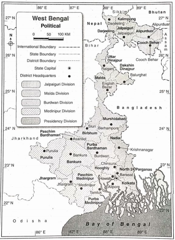
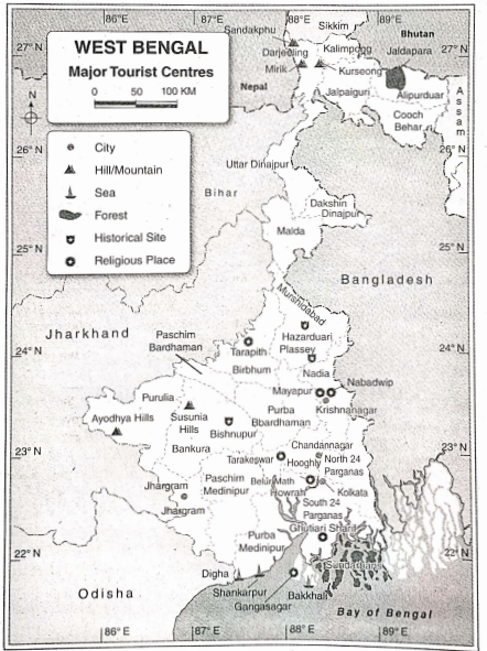
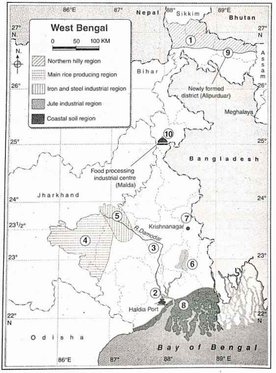
Question 6 Discuss the disaster-prone
Answer:
Disaster-Prone:-
The disaster-prone regions in West Bengal are as follows—
1. The Darjeeling-Himalayan region: This region frequently experiences landslides and floods.
2. The Sunderban region: This region frequently experiences tropical cyclones and floods.
3. The plateau region: The areas under Purulia, Paschim Medinipur, Bankura, Purba and Paschim Bardhaman and
the western part of Birbhum fall under the plateau region. This region frequently experiences the wrath of droughts.
4. The plain region: The plain region consists of the areas that are situated on the bank of the river Ganga or near the Ganga plain in West Bengal. This region experiences heavy monsoons and thus is prone to flood.
Question 7 What measures should be taken to control floods?
Answer:
The measures that should be taken to control flood are—
1. Less human interference in the land: If climatic conditions change naturally, rainfall intensity decreases and as a result, there would be lesser floods. 0 Watershed management and proper drainage system, afforestation, changing the slope by constructing terraces, control of overgrazing, contour-farming etc., can check the occurrence of floods.
2. Barrage construction and dredging:
1. Construct barrages and reservoirs to store excess water from rivers,
2. Construct dykes or dams across rivers at specific locations in order to prevent flooding of low-lying areas, 3. regular dredging of the river bed is needed to lower the level of silt for smooth flow of river water.
3. Proper planning:
1. Implementation of strict laws to bar the construction of houses etc., in flood-prone areas along rivers,
2. Dredging and reclaiming dead and decaying rivers,
3. Increasing public awareness through propaganda and advertisements— by these methods, losses incurred due to floods can be reduced.
Question 8 what measures should be taken during floods to control them?
Answer:
Measures to be taken during floods are—
1. Stay back at home, or at a higher ground when the level of floodwater rises.
2. Keep the following items handy-polythene packets, cord, torch, matchbox, candles, important documents, dry clothes, dry food, radio, mosquito net, pure drinking water etc.
3. Switch off all electrical switches and appliances, close taps and lock gas cylinders.
4. Wait for relief to arrive from government agencies, NGOs etc., and abide by the advice given by them instead of panicking.
Question 9 What measures should be taken to prevent drought?
Answer:
Measures that should be taken to prevent droughts are—
1. Conservation of water: Conservation and appropriate use of water are necessary to prevent drought.
2. Recharge of groundwater: To keep the water supply intact throughout the year, groundwater reservoirs should be recharged properly. Seepage from the ponds and reservoirs can help to recharge the groundwater storage.
3. Dry farming: To stop the excessive use of water in agriculture and to prevent droughts, dry farming should be practised. The use of draught-resistant seeds should be encouraged.
4. Rainwater harvesting: The collection and storage of- rainwater from a roof-like surface and using it properly for irrigation and other domestic purposes is known as rainwater harvesting. It helps to recharge groundwater reservoirs that prevent drought.
5. Stop the wastage of water: Wastage of water in various ways must be checked. It helps to conserve water and also prevent drought.
6. Other measures:
Some other measures that should be taken to prevent drought are—
1. Construction of artificial reservoirs,
2. Increase the efficiency of irrigation, which reduces water wastage,
3. arrange proper distribution of relief to drought-hit victims, etc.
Question 11 What measures should be taken before and during an earthquake?
Answer:
Measures that should be taken before and during an earthquake to control and manage such disaster are as follows—
1. Measures to be taken before an earthquake:
1. Earthquake-resistant houses should be constructed for the people living in an earthquake-prone areas.
2. The basic amenities needed for survival, like drinking water, food, torch, candles, etc., should be stored in adequate amounts.
3. People should also know how to contact the nearest fire station, health-centre etc., in case of exigencies.
2. Measures to be taken during an earthquake:
1. One should leave the house and move to any vacant, open place.
2. One can take shelter beneath any sturdy furniture, like a table, bed, etc.
3. Electricity, gas and water connections should be promptly disconnected when an earthquake strikes.
4. Any kind of inflammable objects like matchboxes, candles, and gas ovens should not be used.
5. One should not try to jump from windows or doors from great heights.
6. People must keep a safe distance from the electrically conductive wire and equipment. It is not advisable to take shelter beneath any multi-storeyed building or tree and should immediately move to any open or vacant place announcements made outside the house.
Question 12 What are the measures that need to be taken to minimise the effects of landslides?
Answer:
Measures that need to be taken to minimise the effects of landslides are—
1. Proper planning should be done after surveying landslide-prone areas.
2. Geological survey is needed and the data should be used while constructing houses, roads, bridges, etc. (in accordance with the local geological structure, rock types, soil, underground water table conditions, etc.)
3. Safe and secured shelters should be constructed near landslide-prone areas beforehand.
4. Felling of trees should be prevented and measures like afforestation should be adopted.
5. The weak and unstable slopes of the mountains should be guarded by putting boulders or concrete in a planned way.
6. Awareness must be created among the local residents regarding the dangerous impacts of landslides.
Question 13 Discuss the measures to be taken for dealing with a cyclonic storm.
Answer:
Measures to be taken for dealing with a cyclonic storm is—
1. Houses should not be constructed on reclaimed land since they have weak foundations. Moreover, storerooms should be made for stocking essential items that would be used during a storm.
2. Important and valuable documents and items should be transferred to a safe place as soon as the announcement of an upcoming storm is made.
3. Foodstuffs like dry food and essential medicines (especially for children and the aged, and for treatment of the injured) should be well-stocked.
4. There should be alternative means of transport and one should be in continuous touch with various governmental and non¬governmental agencies.
Question 14 Discuss the measures to be taken during and after the cyclonic storm.
Answer:
Measures to be taken during a cyclonic storm: Measures to be taken during a cyclonic storm is—
1. A calm mind should be maintained during such a calamity, instead of being panicky and paying attention to rumours.
2. One can take shelter under heavy furniture like a bed or table during a storm.
3. All electrical switches should be turned off.
4. It is not advisable to take shelter near doors and windows or underneath trees.
Measures to be taken after a cyclonic storm: Measures to be taken after a cyclonic storm are—
1. Proper arrangements should be made after assessing the damage caused by such storms.
2. Relief should be arranged properly by contacting local voluntary organisations.
3. First aid should be provided to the injured and doctors should be pooled in for the proper functioning of the healthcare system.
4. Rapid action should be taken by the government to reconstruct shelters and other infrastructural facilities by making a reconnaissance survey of the area and proper estimation.
Question 15 What are the measures to be taken in case of a tsunami forecast?
Answer:
Measures to be taken in case of a tsunami forecast are—
1. Prior warning to the coastal people should be sent by the tsunami warning centre since they receive signals of earthquakes on the seabed (which act as a trigger to cause tsunamis after a. certain gap of time) via satellites.
2. People should be evacuated and removed from the coastal areas to safer and higher grounds.
3. Fishermen should be restricted from going out to the sea for fishing.
4. Tourism activities should be stopped in the coastal areas.
5. The areas on the mouth of rivers, (where they meet the sea) should be avoided by people.
Question 16 Discuss the role of a student in taking measures for disaster management.
Answer:
The students have a major role to play to manage disasters. Usually, there are 3 steps of disaster management—
1. pre-disaster stage,
2. during the disaster stage,
3. post-disaster stage.
1. Pre-disaster stage:
1. Evaluation of risk: The students must have an idea of the area in which they reside and how much it is prone to a disaster. They should be aware of their neighbours and all the members of their family.
2. Spread of awareness: Any place or area can experience a disaster, hence mock drills must be done to make people aware of what measures can be taken to combat it.
For example—
If, any area is prone to flood, how should people reach higher grounds to save themselves, what types of food and medicines they should carry with them, etc., must be rehearsed?
3. Arranging the essential documents: Disasters like floods/cyclones, and earthquakes are sudden events. So, students should keep their essential documents like voter cards, adhaar cards, pan cards, results and certificates, bank documents, etc. close by at the time of quick escape.
Chapter 6 Hazards And Disasters Very Short Answer Questions
Question 1 What is meant by a hazard?
Answer:
Hazard:-
A dangerous condition or event that threatens or has the potential to cause injury to life or damage to property or the environment is known as a hazard.
Question 2 What is meant by a disaster?
Answer:
Disaster:-
A disaster is an event or series of events that results in casualties and damage or loss of property, infrastructure, environment, essential services or means of livelihood on such a scale that is beyond the normal capacity of the affected Community to sustain.
Question 3 What are natural hazards?
Answer:
Natural Hazards:-
Hazards that are typically caused by nature and without any human intervention are known as natural hazards. Examples- Earthquakes, floods, etc.
Question 4 What is meant by a semi-natural hazard?
Answer:
Semi-Natural Hazard:-
Hazards that are caused by the combination of natural and man-induced processes are known as semi-natural hazards. For instance, a landslide is a semi-natural hazard as it can be caused by natural processes (such as heavy or prolonged rainfall, earthquakes, volcanic eruptions, etc.) and can also be caused by man-made activities (such as slope excavation and loading, land use changes, irrigation, and such others).
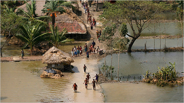
Question 5 What is meant by a flood?
Answer:
Flood:-
A flood may be defined as a situation caused due to the overflow of rivers and other waterbodies due to an excess supply of water.
Question 6 What is meant by a flash flood?
Answer:
Flash Flood:-
A flash flood can develop within a few hours of heavy rainfall. Flash floods can be highly dangerous and have the potential to instantly turn a gasping rivulet into a thundering channel of water that sweeps away everything in its path. Most of the casualties from flooding occur as a result of flash floods. The intensity of flash floods cannot be classified. Desert regions are vulnerable to flash floods.
Question 7 How can dam failure cause floods?
Answer:
Dam Failure Causes Floods:-
Dams are the water storage or diversion barriers that seize water upstream in reservoirs. Dam failure involves. the over¬topping, breach or collapse of a dam. It is an extremely destructive occurrence and in such an event, the energy of the water stored behind even a small dam is capable of causing loss and damage to life and property. For example,-in 1977, Tamil Nadu experienced a dam failure from the Kodaganar Dam that led to over-topping by flood waters.
Question 8 What is meant by drought?
Answer:
Drought:-
Drought may be defined as a situation caused due to lack of rainfall or scarcity of rainfall for a long period. According to the Indian Meteorological Department (IMD), an area is considered to be affected by drought, if it receives less than 75% rainfall than its normal value.
Question 9 What is meant by meteorological drought?
Answer:
Meteorological Drought:-
A drought is categorised as a meteorological drought when actual rainfall over an area is significantly less than the climatological mean. Definitions of meteorological droughts must be region-specific as the atmospheric conditions that result in deficiencies of precipitation are highly variable from region to region.
Question 10 What is meant by hydrological drought?
Answer:
Hydrological Drought:-
A drought is categorised as a hydrological drought when there is a marked depletion of surface water causing very low stream flow and drying of lakes, reservoirs and rivers. Therefore, hydrological drought is related to the effects of periods of precipitation deficits on surface or subsurface water supply.
Question 11 What is meant by agricultural drought?
Answer:
Agricultural Drought:-
The situation when soil moisture is insufficient and results in a lack of crop growth and production, is known as agricultural drought. Agricultural drought has a huge impact on the economy of the country.
Question 12 What is a cyclone?
Answer:
Cyclone:-
A cyclone is a giant whirlwind or a very strong wind system moving rapidly in a cylindrical or funnel shape about a centre of low atmospheric pressure over tropical or subtropical waters. It advances at a speed of about 30 to 50 kilometres per hour and often brings heavy rain.
Question 13 Name the districts of West Bengal that are prone to drought.
Answer:
Districts Of West Bengal That Are Prone To Drought:-
The western uplands of West Bengal consisting of the districts of Bankura, Birbhum, the western part of Paschim Medinipur, jhargram and Purulia are the most drought-prone districts of the state.
Question 14 What is meant by a landslide?
Answer:
Landslide:-
A landslide is the movement of rocks or debris down a slope. Landslides occur when gravitational and other types of shear stress within a slope exceeds the shear strength of the materials that form the slope. Landslides are also known as landslips, slope failure, etc.
Question 15 What is meant by a snowstorm?
Answer:
Snowstorm:-
A snowstorm is a severe weather condition where precipitation falls in the form of snow and creates a hazardous condition. It is characterised by low temperatures, strong winds and enormous quantities of either falling or blowing snow.
Question 16 Where do snowstorms mostly occur?
Answer:
Occur Of Snowstorms:-
People experience snowstorms in middle-latitude to high-latitude areas during winter. The occurrence of snowstorms is most prominent in Antarctica, northern parts of North America, Canada, north of Europe and Asia as well as in New Sout Wales in Australia. The snowcapped high mountainous regions also experience snowstorms.
Question 17 Name the most commonly faced hazards and disasters in West Bengal.
Answer:
The most Commonly Faced Hazards And Disasters In West Bengal Are:-
The most commonly faced hazards and disasters in West Bengal are drought, flood, landslides and tropical cyclones.
Question 18 What is meant by the forest fire?
Answer:
Forest Fire:-
A forest fire, also known as a wildland fire or wildfire, is an uncontrolled fire often occurring in forest areas. The blazes are fueled by lightning, volcanic eruptions, pyroclastic flow from active volcanoes, heat waves, droughts, and cyclical climate changes. as El Nino as well as human carelessness. It is observed that more than four out of every five forest fires are human-induced. Forest fires often begin unnoticed, but they spread quickly at a speed that extends up to 23 kilometres an hour igniting bushes, trees, homes and agricultural resources.
Question 19 Name the districts of West Bengal that are prone to cyclones.
Answer:
Districts Of West Bengal That Are Prone To Cyclones Are:-
The coastal area in West Bengal mostly faces the wrath of tropical cyclones. The districts of Purba Medinipur, North and South 24 Parganas, Howrah, Hooghly and Kolkata are more susceptible to the hazard caused due to tropical cyclones.
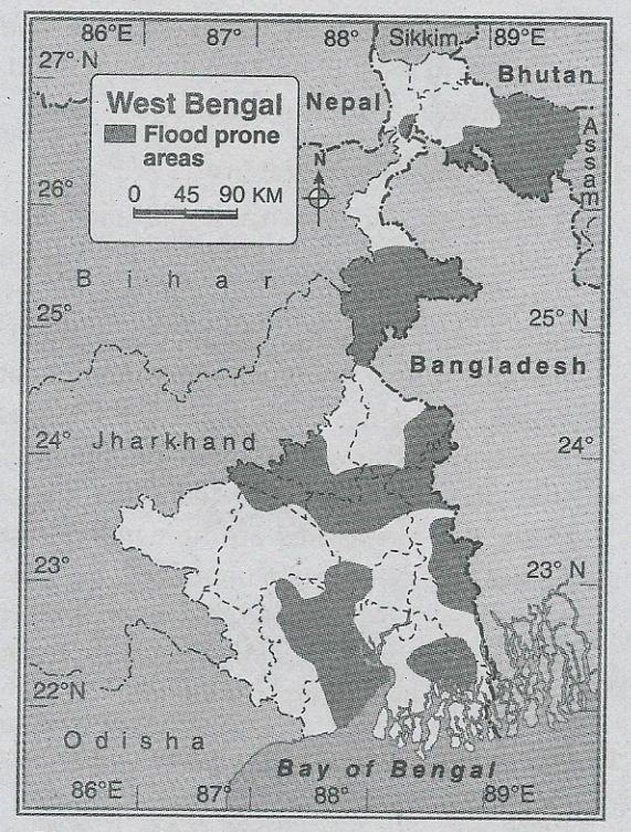
Question 20 Name the districts of West Bengal that are prone to flood.
Answer:
Districts Of West Bengal That Are Prone To Flood Are Given Below:-
West Bengal is one of the most flood-prone states of India. The flood-prone areas of West Bengal include low-lying areas, coastal regions and regions along rivers downstream from dams.
The flood-prone districts of West Benga I can be classified into two groups—
1. Districts of North Bengal: Cooch Behar, Jalpaiguri, Malda, Uttar and Dakshin Dinajpur.
2. Districts of South Bengal: Nadia, Howrah, Murshidabad, North and South 24 Parganas, Hooghly, Purba and Paschim Bardhaman, Birbhum, Purba and Paschim Medinipur.
Question 21 Classify drought on the basis of medium.
Answer:
On the basis of medium drought can be classified into two types—
1. Soil drought: It is the condition when soil moisture depletes and falls short of meeting the potential evapotranspiration of the crop.
2. Atmospheric drought: This occurs due to low humidity, and dry and hot winds that cause the desiccation of plants.

Question 22 What is meant by an earthquake?
Answer:
Earthquake:-
Seismic waves are produced when some form of energy stored in the earth’s crust is abruptly released. This happens usually when masses of rock layers push one another abruptly. Therefore, earthquakes or any sudden shaking of the ground are caused by seismic waves originating within the earth’s crust.
Question 23 What is meant by a tsunami?
Answer:
Tsunami:-
A catastrophic ocean wave, generally caused by an earthquake on the seabed by an underwater or coastal landslide or by the eruption of a volcano is known as a tsunami. It is derived from a Japanese word meaning harbour waves. It is also commonly referred to as a seismic sea wave or tidal wave.
Question 24 What is meant by volcanism?
Answer:
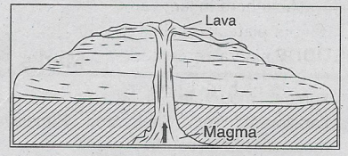
Volcanism:-
Volcanism is the process that refers to hot molten magma escaping from the earth’s core, cooling down and forming hard rocks. Volcanism can be of three types depending on the place where it occurs.
They are as follows—
1. Extrusive volcanism: Molten lava that escapes the earth and reaches the surface is known as extrusive volcanism.
2. Intrusive volcanism: Molten magma that cools and hardens beneath the surface of the earth is known as intrusive volcanism.
3. Plutonic volcanism: Molten magma that cools and hardens deep beneath the surface of the earth, far below the crust is known as plutonic volcanism.
Question 25 What is an avalanche?
Answer:
Avalanche:-
When accumulated snow and ice slide down along the steep slopes (35°-45°) of mountains, encompassing a wide area, it is called an avalanche. At the higher altitude of the mountain slopes, the upper part of the accumulated ice breaks apart from the underlying layer of ice. It hurls down along the steep slopes as a vast expanse of white sheets mainly due to the earth’s gravity. This phenomenon mostly occurs during the winter months and is a common feature in the mountainous areas of the Himalayas and the Alps.
Question 26 What is meant by a disaster-prone area?
Answer:
Disaster-Prone Area:-
An area that has already faced one or more types of hazards is demarcated as a disaster-prone area. This is because the area is prone to several kinds of hazards. For example, Darjeeling and Kalimpong districts and the coastal area of Purba Medinipur district of West Bengal are landslides and cyclone-prone areas respectively.
Question 1 What is vulnerability?
Answer:
Vulnerability:-
Vulnerability can be defined as the impaired capability of, any individual or group to conceive of, cope with, resist and recover from the impact of a natural, semi-natural or man-induced hazard. Vulnerability develops when an individual or a small group is isolated, insecure and defenceless, before or after they face any hazard, shock or stress. In this context, more preparedness to face a disaster means lesser vulnerability.
Question 2 Name the districts of West Bengal that are prone to flood.
Answer:
The flood-prone districts of West Bengal can be classified into two groups—
1. Districts of North Bengal: Cooch Behar, Jalpaiguri, Malda, Uttar and Dakshin Dinajpur.
2. Districts of South Bengal: Nadia, Howrah, Murshidabad, North and South 24 Parganas, Hooghly, Bardhaman, Birbhum, Paschim Medinipur and Purba Medinipur.
Question 3 What are the three phases in a disaster management cycle?
Answer:
The three phases in a disaster management cycle are—
1. pre-disaster phase,
2. during the disaster phase,
3. post-disaster phase.
4. What is meant by disaster management?
Answer:
Disaster Management:-
Disaster is any kind of temporary or permanent damage entailing a loss of human life and disruption of normal activities (due to natural or man-made causes) and cannot be dealt with without external aid. Disaster management is the means to control and restore such a disruptive situation (through various measures).
Chapter 6 Hazards And Disasters Fill In The Blanks
1. A region is considered to be drought-prone if it receives an average annual rainfall less than 75 % of its normal value.
2. The centre of a cyclone is known as its eye
3. The Richter scale is used to measure the magnitude of earthquakes
4. The average speed at which grass fires spread can be up to 22km/hour
5. Forest fire is a semi-natural hazard.
6. One of the deadliest snowstorms in history occurred in Iran in the year 1972
7. Low pressure prevails at the centre of a whirlwind.
8. Darjeeling is an example of a landslide-prone district in West Bengal.
9. The possibility of flash floods is higher in a circular river basin.
10. Avalanches are more likely to occur on convex slopes.
11. Cyclone AHA hit West Bengal in the year 2009
12. Phailin is a cyclone
13. Blizzard is a type of snowstorm
14. The Kedarnath temple was affected severely due to a flash flood in 2013.
15. One of the most accepted weather conditions for hurricanes to develop is that the temperature of the ocean waters must be above 26° C
16. Agricultural droughts can develop quickly during a dry spell if absolutely no rain is observed and the soil does not have enough water to sustain crops.
17. The disaster is a cause hazard.
18. Famine is an acute shortage of food that causes people to die of starvation.
19. About 12 % of the total land mass in India is prone to flood.
20. Most tsunamis occur on the Pacific coast.
21. Air pollution occurs due to volcanic eruptions.
22. Cooch Behar is a flood-prone district in West Bengal.
23. Extreme disasters like famine occur as a result of drought
24. Extreme Growth of the population is a type of man-induced disaster.
25. Disaster is an extreme condition or hazard
26. A cyclone is known as a Hurricane in the Caribbean Sea.
27. The most earthquake-prone region of India is Aila
28. In the year 2009, the severe cyclone that affected West Bengal is known as 26° C
29. Phailin storm developed in the Bay of Bengal
30. Purulia is an example of a drought-prone district in West Bengal.
31. Irrigation facility is necessary for drought-prone areas.
32. Students play an important role in disaster management.
33. The influence of cyclones can be felt more in the coastal region of southern West Bengal.
34. The Ring Dam is constructed for the prevention of flood
35. Distribution of proper medicine and food to disaster victims is a part of relief management.
36. One should go out of the house during an earthquake.
37. Dry farming is a measure that may prevent drought
Chapter 6 Hazards And Disasters Write True Or False
1. Plutonic earthquakes are deep-focus earthquakes, the depth of disturbances being between 250 km and 700 km approximately. True
2. The downward flow of magma is known as a ‘plume’. false
3. Not all hazards can be termed as disasters. True
4. When a river flows in a straight direction, the possibility of flood decreases. True
5. Whirlwinds are common in the hills. false
6. Most avalanches occur on slopes with an angle of inclination between 35° and 45° approximately. false
7. A tornado is a severe cyclone. True
8. Avalanches most commonly occur on the leeward slopes of mountains. True
9. Earthquakes are one of the main causes of tsunamis. True
10. Snowstorms are one of the major natural disasters faced by the people of Sunderbans. false
11. Remote sensing and GIS help in disaster management. false
12. Fujiyama is a volcano in India. false
13. Snowstorms reduce visibility sharply. false
14. When floods occur, old alluvium accumulates on a floodplain. false
15. Droughts are generally categorised into 5 classes. false
16. Narcondam and Barren are two volcanoes in India. True
17. Snowfall is a man-made disaster. false
18. Ecosystems are affected enormously due to landslides. True
19. Damages caused by disasters are much greater than those caused by hazards. True
20. A tornado is a man-made hazard. false
21. Acid rain does not cause any damage to the aquatic ecosystem. false
22. Reckless deforestation can cause landslides in hilly regions. True
23. A seismograph is used to measure the intensity of tsunamis. false
24. Avalanches are more likely to occur on concave slopes. false
25. For hurricanes to develop, the temperature of the ocean waters must be above 26° C. True
26. Blizzards are common in Antarctica. True
27. According to the Irrigation Commission, drought is a situation that occurs in a region where the annual rainfall is less than 75% of the normal rainfall. True
28. A seismograph is used to know the movement of earthquakes. True
29. If the intensity of the hazard increases, there is a possibility of disaster. True
30. Both P and S waves are known as surface waves. false
31. Soil moisture increases due to excessive withdrawal of groundwater.
32. Drought is a slow-onset disaster. True
33. Blizzard is also known as an avalanche. false
34. Many people died at Bhuj in Gujarat due to a severe earthquake. True
35. Uttarakhand is an earthquake-prone region in India. True
36. The western part of West Bengal is a region prone to man-induced floods. True
37. Awareness of the people is important for the prevention of disaster. True
38. Cloud burst affected region of West Bengal is Purulia. false
39. The east coast of India is a tsunami-affected region. True
40. During an earthquake, one should leave the house and move to any vacant place.
41. Houses of Darjeeling and Kalimpong are built of wood due to the effect of the cyclone. false
Chapter 6 Hazards And Disasters Match The Column
1.
| Left Column | Right Column |
| 1. Landslide | A.Plains |
| 2. River bank erosion | B. Forest regions |
| 3. Forest fire | C. Polar regions |
| 4. Snowstorm | D. Mountains |
Answer: 1-D,2-A,3-B,4-C
2.
| Left Column | Right Column |
| 1. Natural hazard | A. War |
| 2. Semi-natural hazard | B. Volcano |
| 3. Man-made hazard | C. Landslide |
Answer: 1-B,2-C,3-A
3.
| Left Column | Right Column |
| 1. Drought | A.Ministry of Home Affairs |
| 2. Flood | B. Ministry of Agriculture |
| 3. Chemical accidents | C. Department of health and family welfare |
| 4. Epidemic | D. Ministry of Water Resources |
Answer: 1-B,2-D,3-A,4-C
Chapter 6 Hazards And Disasters Answer In One Word
Question 1. Which type of hazard is easiest to manage?
Answer: Man-made hazards.
Question 2. Which force is one of the factors behind the occurrence of avalanches?
Answer: Gravitational force.
Question 3. Which type of hazard is a Tornado?
Answer: Natural hazard.
Question 4. Name a man-made cause for landslides in the mountains.
Answer: Reckless deforestation.
Question 5. What type of disaster may occur if no rain falls for a long period?
Answer: Drought.
Question 6. In Which type of climate is snowfall a common affair?
Answer: Extremely cold climate.
Question 7. Which instrument is used to measure the intensity of earthquakes?
Answer: Seismograph.
Question 8. Which type of hazard is a volcano?
Answer: Natural hazard.
Question 9. Name a semi-natural hazard.
Answer: Landslide.
Question 10. Name a man-made disaster.
Answer: War.
Question 11. Name a flood-prone district in West Bengal.
Answer: Cooch Behar.
Question 12. Give a non-tectonic cause of earthquakes.
Answer: Nuclear testing.
Question 13. Cite a recent example of a very severe cyclonic storm that occurred in India.
Answer: Aman.
Question 14. Name the wind that influences the occurrence of both droughts and floods in India.
Answer: Monsoon wind.
Question 15. Into how many divisions can hazards be classified?
Answer: Three.
Question 16. In which year was Uttarakhand affected severely due to a flash flood?
Answer: 2013.
Question 17. Which disaster destroyed the city of St. Pierre in 1902?
Answer: Volcanic eruption.
Question 18. Which type of natural hazard occurs when trees rub against each other?
Answer: Forest fire.
Question 19. What percentage of the total land area in India is prone to flood?
Answer: 12
Question 20. Name a disaster that may result in landslides.
Answer: Earthquake.
Question 21. Which kind of disaster can be prevented by adopting proper patterns and methods of land use on the hill slopes?
Answer: Landslides.
Question 22. Which area of India is mostly affected by tsunamis?
Answer: Coastal regions.
Question 23. Which mountain range in India is most prone to earthquakes?
Answer: The Himalayas.
Question 24. What are the adverse effects resulting from natural processes of the Earth called?
Answer: Natural hazards.
Question 25. Which type of disaster may result due to faulty and unscientific methods of farming in the hills?
Answer: Landslides.
Question 26. Cite an example of a geological disaster.
Answer: Earthquake.
Question 27. Cite an example of a hazard associated with landscape change.
Answer: River bank erosion.
Question 28. Which type of disaster are whirlwinds and snowstorms?
Answer: Atmospheric disaster.
Question 29. What type of disaster may result due to human intent, negligence or a failure of a man-made system?
Answer: Man-made disaster.
Question 30. Which type of disaster may occur due to sudden heavy rainfall in the hills?
Answer: Flash flood.
Question 31. Name a natural cause of earthquakes.
Answer: Movement of the earth’s plate.
Question 32. Name a man-made cause of earthquakes.
Answer: Nuclear tests.
Question 33. What is the rapid flow of snow down a sloping surface known as?
Answer: Avalanche.
Question 34. Which region in West Bengal is most prone to landslides?
Answer: The hilly regions in Darjeeling.
Question 35. What is planning to cope with disasters known as?
Answer: Disaster management.
Question 36. Which type of rain causes damage to the aquatic ecosystem?
Answer: Acid rain.
Question 37. Which type of hazard may lead to a disaster in the forest regions?
Answer: Forest fires.
Question 38. What kind of disaster results from excessive rainfall?
Answer: Flood.
Question 39. Into how many divisions can seismic waves be classified?
Answer: Three.
Question 40. What type of disaster devastated the city of Bhuj in Gujarat in 2001?
Answer: Earthquake.
Question 41. Name one of the most prominent causes of tsunamis.
Answer: Earthquake.
Question 43. In which type of drainage basin is the probability of flash floods highest?
Answer: Circular drainage basin.
Question 42. What type of disaster is the Phailin?
Answer: Very severe tropical cyclone.
Question 44. Which type of disaster is most prominent in the coastal regions of South Bengal?
Answer: Cyclone.
Question 45. On which slopes are avalanches more likely to occur?
Answer: Convex slopes.
Question 46. Which type of disaster is most prominent in the Darjeeling district of West Bengal?
Answer: Landslide.
Question 47. Which type of disaster is most prominent in the Puruiia district of West Bengal?
Answer: Drought.
Question 48. Cite an example of a type of severe cyclone.
Answer: Tornado.
Question 49. What are deep-focus earthquakes known as?
Answer: Plutonic earthquakes.
Question 50. Name two important volcanoes in India.
Answer: Narcondam and Barren.
Question 51. What is the helpless condition caused due to the occurrence of hazards and disasters known as?
Answer: Vulnerability.
Question 52. Which type of hazard is global warming?
Answer: Man-induced hazard.
Question 53. Which kind of disaster is more common in the fluvial plain region?
Answer: Flood.
Question 54. On which coast of India does cyclone Fani hit first?
Answer: Coast of Odisha.
Question 55. Which sea was the source of cyclone Fani?
Answer: Bay of Bengal.
Question 56. What type of cyclone is Fani?
Answer: Tropical cyclone.
Question 57. Into how many sub-types can disaster management be mainly classified?
Answer: Two.
Question 58. To control which type of disaster does the Ministry of Water Resources play a significant role?
Answer: Flood.
Question 59. Which ministry is responsible for dealing with the Integrated Drought Management Programme in India?
Answer: Ministry of Agriculture.
Question 60. What are the main reasons for the construction of wooden houses in mountainous regions?
Answer: Landslides and earthquakes.
Question 61. Name a ‘Tsunami warning method’.
Answer: (Deep-ocean Assessment and Reporting of Tsunamis).
Question 62. Name a recent cyclone in India.
Answer: Aman (2020)