WBBSE Chapter 3 Determination Of Location Of A Place Of The Earth’s Surface Long Answer Questions
Question 1. What is meant by parallels of latitude? Discuss their properties and their uses.
Answer: Parallels of latitude: The imaginary lines drawn around the Earth parallel to the Equator are known as the parallels of latitude. These lines join all the places with the same latitudinal value.
Read and Learn Also WBBSE Solutions for Class 9 Geography And Environment
Properties and uses of the parallels of latitude: The properties and uses of the parallels of latitude are as follows- Determination of Location of a Place on the Earth’s Surface
Properties: The properties of the parallels of latitude are-
The parallels of latitude are full circles and parallel to each other.
As the value of the latitudes increases, the circumference of the parallels of latitude gradually decreases. At the Poles, the parallels of latitude appear to be dotted.
All places on the same parallel of latitude have the same latitudinal value. Solar incidence changes with changing latitude. Accordingly, the climatic characteristics of the places also vary. The local times of various places lying on the same latitude are different based on their longitudinal value.
Uses: The uses of the parallels of latitude are- The north-south position of a place can be determined by using the Equator and the other latitudes as standards of measurement. The parallels of latitude are often used as the boundary of a country or a state. For instance, the 45° N parallel forms an approximate border between Quebec (Canada), and the states of New York and Vermont in the USA. The Earth can be divided into different heat zones (Torrid zone, Temperate zone, and Frigid zone) based on the parallels of latitude.

Question 2. How can you determine the latitude of a place geometrically? How can the latitude of a place in the northern hemisphere be determined using the elevation of the Pole Star?
Answer: Geometric determination of the latitude of a place:
In the given picture, B denotes the Earth’s center, DC the Equator, A the North Pole, and P the Pole Star. N is a place in the northern hemisphere with MO as its horizon. Moreover, BQ is perpendicular to MO. As the Pole Star is located vertically above the North Pole, it will be visible at P’ position from N. Consequently, the angle of elevation of the North Star, as visible from N, would be ZMNP’ and the latitudinal degree of N would be <NBC.

Now <MNP’+<QNP’= a right and <PBN + < NBC= a right angle
Therefore, ZPBN + ZNBC = <MNP’ + ZQNP’
Moreover, since BP and NP’ are parallel to each other, ZPBN = ZQNP’ Hence, NBC = ZMNP’ [since 90° <PBN = 90° – <QNP’]
Therefore, the angle of elevation of the Pole Star, as visible from N = the latitudinal degree of N.
Determination Of Location Of A Place On Earth’s Surface WBBSE
1. Using the elevation of the Pole Star to determine the latitude of a place in the northern hemisphere:
In an open place poles, one taller than the other, are fixed. The smaller pole is fixed south of the taller one in such a way that the taller pole is to its north and the Pole Star as visible in the sky, are all in a straight line[Diagram (a)]. Now, after measuring the exact distance between the poles, on white paper, the poles need to be drawn to the scale.[Diagram (b)].
Therefore, YR and ZS are the two poles, with RS being the distance between them. Now, Y and Z are joined, and simultaneously, SR is extended so that these two meet at point D and form an angle <ZDS. Hence, <YDR is the angle of elevation of the Pole Star and also the latitudinal degree. So, if the,<YDR is measured with the help of a protractor, the latitude of the place can be determined.

Question 3. Why is it necessary to determine the location of a place?
Answer: Necessity of determining the location of a place: It is necessary to determine the location of a place, because-
To find the exact position: It helps us to find the exact position of a country, a state, a city, a mountain, or any other place on the Earth’s surface.
To find the distance: It helps to find the distance between any two or more objects and places.
For geographical research and study: The location of a place helps us to understand the explanation of any geographical research and study.
To know climatic character: The climatic characteristics of a place can be known more or less if the location of the place is known.
For disaster management: Determination of location is necessary for relief and rescue management in various disasters.
For transport and navigation: It is necessary to know the location of a place for water transport or navigation and to access resources of particular places.
For defense purposes: It helps to know the location of the enemy for defense or military purposes and helps to launch counter-attacks.
To demarcate boundaries: Determination of the location is necessary to demarcate political boundaries.
For development planning: The location of a place also helps us to assign proper development plans for backward regions.
Question 4. How can the Earth be divided into various heat zones?
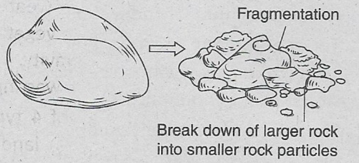
Answer: Heat zone: The Earth is divided into three heat zones based on the angle at which the sunrays fall. These are as follows-
1. Torrid zone: This zone extends from the Equator (0°) to the Tropic of Cancer (23½º N) in the North and to the Tropic of Capricorn (23½º S) in the South. Sunrays fall vertically on this region throughout the year. Some important countries that fall under this zone are Brazil, Venezuela, Nigeria, Kenya, Ghana, Malaysia, Indonesia, England, etc.

2. Temperate zone: This zone extends from the Tropics (231⁄2° N and S) to the Arctic and Antarctic Circles (66%1⁄2° N and S). This zone experiences moderate heat throughout the year because the sun’s rays do not fall directly on this zone. Some countries that come under this zone are- the United States of America, Chile, France, South Africa, New Zealand, England, Canada, Japan, Germany, Italy, and several others.
3. Frigid zone: This zone extends from the Arctic and Antarctic Circles (66½° N and S) to the Poles (90½° N and S). The frigid zone is the coldest region of the Earth because this region lies farthest from the Equator and receives a very low amount of sun rays. Throughout the year. Some regions that fall under this zone are Antarctica, Siberia, Alaska, Greenland, northern Canada, Norway, and the northern parts of Sweden.
Question 5. According to the local time is 4.30 pm. If it is noon at the place named P then, what is the longitude of that place?
Answer:
Determination of the longitude of the place named P:

The time difference between Greenwich and P is
(16:30 – 12:00) hrs = 4 hrs 30 mins For a 1-hour time difference, the longitudinal difference is 15°
∴ For a 4-hour time difference, the longitudinal difference is 15 x 4 = 60°
Again for 4 minute time difference, the longitudinal difference is 1°
∴ For a 1-minute time difference, the longitudinal difference is -¼º
∴ For 30 30-minute time difference, the longitudinal difference is 30º/4 = 7.5° = 7°30′
Therefore Total longitudinal difference is 60° + 7°30′ = 67° 30’
As the local time of P is behind that of Greenwich, that means, the place P must lie to the west of Greenwich. So, the longitude of P is 67°30′ W.
Question 6. The local time of places A and B are 6 am and 6 pm respectively. Determine the longitude of A and B if the Greenwich Time is noon.
Answer:
Determination of the longitude of the places named A and B:
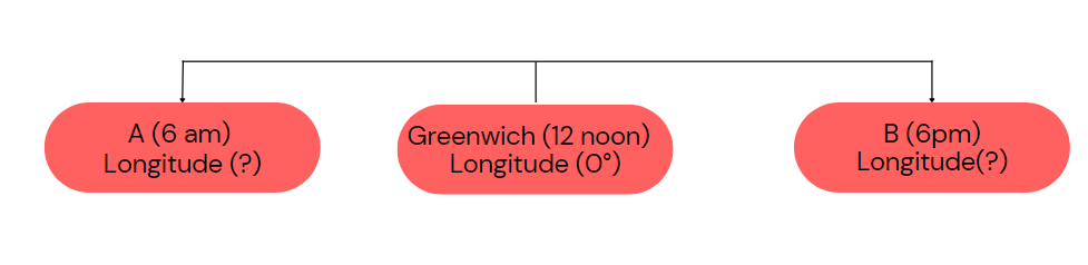
The time difference between Greenwich and place A is (12 hrs – 6 hrs) = 6 hrs.
Now, for a 1-hour time difference, the longitudinal difference is 15°
∴ For 6hours time difference, longitudinal difference is 15° x 6 = 90°
∴ The longitudinal difference between place A and Greenwich is 90°
As the local time of place, A is behind that of Greenwich, that means place A lies to the west of Greenwich. So, the longitude of place A is 90° W.
Again time difference between Greenwich and place B is (18 hrs or 6 pm -12 hrs) 6 hrs.
Now, for a 1-hour time difference, the longitudinal difference is 15°
∴ For a 6-hour time difference, the longitudinal difference is 15° x 6 = 90°
The longitudinal difference between place B and Greenwich is 90°.
As the local time of place B is ahead of Greenwich local time, that means place B lies to the east Of Greenwich. So, the longitude of place B is 90° E.
∴ The longitude of places A and B are 90° W and 90° E respectively.
Question 7. When it is midday or noon in Greenwich?
Answer:
Determination of the local time of Kolkata:
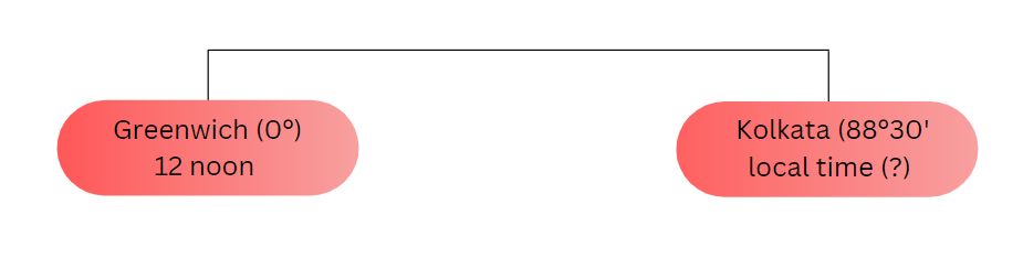
The longitudinal difference between Kolkata and Greenwich is 0º and Kolkata is to the east of Greenwich.
Therefore Longitudinal difference between Kolkata and Greenwich is (88°30′-0°) = 88°30′
For a 1° longitudinal difference, the time difference is 4 min
∴ For an 88° longitudinal difference, the time
difference is 88 x 4 = 352 mins = 5 hrs 52 mins
Again, for the V longitudinal difference, the time difference is 4 seconds
Therefore For a 30′ longitudinal difference, the time difference is 30 x 4 = 120 seconds = 2 mins
∴ The total time difference between Greenwich and Kolkata is (5 hr 52 mins + 2 mins) = 5 hrs 54 mins. As Kolkata is to the east of Greenwich, the local time of Kolkata is ahead of Greenwich’s local time.
∴ The local time of Kolkata is (noon + 5 hrs 54 mins) = 17 hrs 54 mins = 5:54 pm.
How To Determine Location On Earth Class 9 WBBSE
Question 8. An important radio broadcast from Olympia (22°23′ East) at 9 am on Monday has to reach Los Angeles (118°17′ West) in the USA. If it takes 15 minutes to send or receive a message, then when will the message arrive in Los Angeles?
Answer:
Message arriving time in Los Angeles:
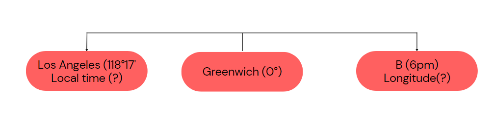
Longitudinal difference between Olympia and Los Angeles is(22°23′ + 118° 17′) = 140° 40′
Now, for a 1° longitudinal difference, the time difference is 4 mins
∴ For 140° longitudinal difference, time difference is 140 x 4 mins = 560 mins = 9 hrs 20 mins
Again, for a 1′ longitudinal difference, the time difference is 4 seconds – For a 40′ longitudinal difference time difference is 40 x 4 = 160 seconds = 2 mins 40 secs,
∴ For the 140°40′ longitudinal difference, the time difference is (9 hrs 20 mins + 2 mins 40 secs) = 9 hrs 22 mins 40 secs.
As Los Angeles is located to the west of Olympia, so local time in Los Angeles will be behind that of Olympia.
Therefore, while the local time in Olympia is 9 am, the local time in Los Angeles would be (9 am -9 hrs 22 mins 40 secs)
= (24 hrs + 9 hrs) – 9 hrs 22 mins 40 secs
= 33 hrs – 9 hrs 22 mins 40 secs
= 23 hrs 37 mins 20 secs
= Sunday night 11 hrs 37 mins 20 secs
Now, It takes 15 minutes to send or receive a message.
∴ The radio news will reach Los Angeles on the previous night at 11 hrs 37 mins 20 secs + 15 mins i.e., on Sunday at 11:52:20 pm.
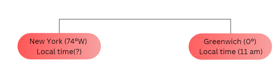
Question 9. What would be the local time in New York {74° W) and Mumbai (73° E), when it is noon in Greenwich?
Answer:
Local time in New York and Mumbai:
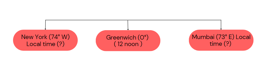
Mumbai and New York are located to the east and west of Greenwich respectively.
∴ The longitudinal difference between Greenwich and New York is (74° -0°) = 74°
Now, for a 1° longitudinal difference, the time difference is 4 mins
∴ For the 74° longitudinal difference, the time difference is (74 x 4) mins = 296 mins = 4 hrs 56 mins As New York is located to the west of Greenwich, so, the local time of New York will be behind that of Greenwich.
When the local time is noon at Greenwich, the local time of New York would be (12 noon – 4 hrs 56 mins) =7:04 am On the other hand, the longitudinal difference between Greenwich and Mumbai is (73°-0°) = 73°
Since For 1° longitudinal difference, the time difference is 4 mins
Therefore the 73° longitudinal difference time difference is 73 x 4 mins = 292 mins = 4 hrs 52 mins As Mumbai is located to the east of Greenwich, the local time at Mumbai would be ahead of Greenwich.
While local time is noon in Greenwich, the local time in Mumbai would be (noon + 4 hrs 52 mins) = 16 hrs 52 mins = 4:52 pm.
While local time is noon in Greenwich, the local time of Mumbai and New York would be 4:52 pm and 7:04 am respectively.
Question 10. The local time of places X and Y are Saturday at 9 pm and Sunday at 3 am respectively. The longitude of X is 90° W. Determine the longitude of Y. 2. What will be the time of 1ST when the Chronometer shows noon?
Answer
1. Determination of the longitude of Y:
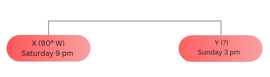
The local time of places X and Y are Saturday at 9 pm and Sunday at 3 am respectively. Therefore, the difference in local time between X and Y is—
(Saturday 9 pm – Sunday 3 am) i.e., [Saturday (24h – 21h = 3h) + Sunday 3h ] = 6 hrs or 360 mins.
Now, we know that for every 4-minute time difference, the longitudinal difference is 1°.
∴ For 360 the minute time difference, the longitudinal difference will be 360 4÷4 = 90°
Hence, the longitudinal difference between X and Y is 90°.
Since the local time of Y is ahead of the local time of X, this means, Y is located to the east of X.
Therefore, the longitude of Y is (90°W- 90°) = 0°.
Earth’s Surface Location Determination WBBSE Solutions
2. Determination of the time of 1ST:
The Chronometer runs based on Greenwich time. Therefore, if it is noon according to the Chronometer, then it can be said that the time at Greenwich or the Prime Meridian (0°) is also noon. On the other hand, it is also known that the Standard Meridian of India is 82° 30′ E. Hence, the longitudinal difference between the Prime Meridian i.e., the GMT and 1ST is— (82°30’E – 0°) = 82° 30′. Now the time difference. For 82° 30,’ the longitudinal difference will be—
For every 1° longitudinal difference, the time difference experienced is 4 minutes. Therefore, for an 82° longitudinal difference, the time difference will be Therefore, for a 30′ longitudinal difference, the time difference. Will be(30×4) = 120 seconds or 2 minutes.
So, the total time difference between GMT and 1ST becomes (328 + 2) = 330 minutes or 5hrs 30mins.
Since the Standard Meridian of India is located to the east of the Prime Meridian, so 1ST would be ahead of GMT.
Therefore, when it is noon according to GMT, the time according to 1ST would be (12hrs + 5hrs 30mins) =17:30 hours or 5:30 pm.
Question 11. The longitude of places A and B are 20° E and 35°E respectively. What will be the local time of B when it is Sunday at 11 pm at A? A news broadcast at 8 am from Greenwich. What will be the longitude of the place that receives that broadcast at 2:30 pm?
Answer:
1. Determination of the local time of the place B:
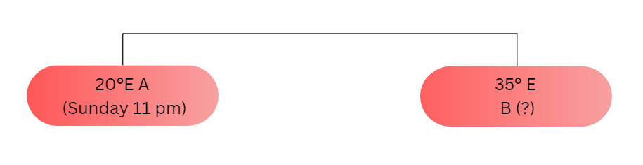
It is known that the longitudes of A and B are 20° E and 35° E respectively.
Hence, the longitudinal difference between A and Bis (35°E-20°E) = 15°.
For every 1° longitudinal difference, the time difference experienced is 4 minutes, Therefore, for a 15° longitudinal difference, the time difference will be (15 x4) = 60 minutes or 1 hour.
Since B is located to the east of A, so the time of B would be ahead of A.
(82 x 4) = 328 minutes.
Therefore, when it is Sunday 11 pm at A, the time at B would be (Sunday 11 pm + LH) i.e., (23hrs+1hrs) = 24hrs or Monday 00:00.
2. Determination of the longitude of the message receiving place:
The news broadcasts at 8 am from Greenwich (0°) and is received at the given place at 2:30 pm. Therefore, the difference in local time between Greenwich and the given place is—
(2:30 pm – 8 am), i.e., (14hrs 30mins – 8hrs) = 6hrs 30mins or 390mins.
Now, for every 4-minute time difference, the longitudinal difference is 1°. Therefore, for a 390mins time difference, the longitudinal difference will be 390÷4 = 97°30′
As per the question, the time of the unknown (message receiving) place is ahead of Greenwich, so the unknown place would be located to the east of Greenwich (0°). Therefore, the longitude of the unknown place would be (0° + 97°30′) = 97°30’E.
Question 12. The captain of a ship notices that the local time at a port, where his ship has just reached, is 7:30 pm. But the Chronometer then shows the time 11:46 pm. What is the longitude of the port where the ship has reached? 2. How can the latitude be determined concerning Hadley’s
Octant?
Answer:
1 Determination of the longitude of the port:
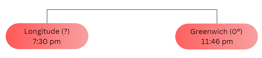
The Chronometer runs based on Greenwich time. When the ship reached the port at 11:46 pm according to Greenwich time, the local time of the port was 7:30 pm.
Therefore, the time difference between these two places would be (11:46 pm – 7:30 pm) i.e./ (23hrs 46mins – 19hrs 30mins) = 4hrs 16mins or 256mins.
Now, for every 4-minute time difference, the longitudinal difference is 1°.
Therefore, for a 256 mins time difference, the longitudinal difference will be 256 4÷4 = 64° So, the longitudinal difference between Greenwich and the port is 64°
As it is known that the local time of the port is behind that of Greenwich, the port would be located to the west of Greenwich (0°). Therefore, the longitude of the port would be (64° – 0°) =64° or 64° W
2. Determination of latitude concerning Hadley’s Octant:
Hadley’s Octant is a constellation of stars in the southern sky that is noteworthy as a marking of the geographical South Pole. In ancient times, people used the Pole Star to determine the north and Hadley’s Octant to determine the south. The Hadley’s Octant is visible in the night sky from all places in the southern – hemisphere but its angle of elevation is not the same at all places.
The angle of elevation changes with varying latitudes. The angle of elevation of Hadley’s Octant near the Equator is zero and thus the Equator is measured as 0° latitude. From the Equator, if we move 111.3 km to the south, we reach the 1° S latitude, and the angle of elevation of Hadley’s Octant at 1° S is measured to be 1°. In the same sequence, the angle of elevation of Hadley’s Octant is measured to be 90° or exactly vertical at the South Pole. Therefore, concerning the angle of elevation of Hadley’s Octant from the horizon of a place, the latitude of the place can be easily determined.
Question 13. New York is located at 74° W. What would be the time in New York when it is 11 am in Greenwich? 2. Determine the difference in the local time of a place and its antipodal point.
Answer:
1. Determination of the local time of New York:
The longitude of Greenwich is 0°.
Therefore, the longitudinal difference between Greenwich and New York is ( 74° – 0°) = 74°
Now, for the 1° longitudinal difference, the time difference is 4mins.
So, for a 74° longitudinal difference, the time difference will be 74 x 4 = 296 mins or 4hrs 56mins.
As New York is located to the west of Greenwich, the local time of New York will be behind Greenwich time.
Therefore, while it is 11 am at Greenwich, the time in New York would be (l hrs-4hrs 56mins) = 6hrs 04mins or 6:04 am.
2. Determination of the difference in local time of a place and its antipodal point:
The anti-pod of a point is a point on the Earth’s surface that is diametrically opposite to it.
So, the longitudinal difference between these two places is always 180°.
We know, that for a 1° longitudinal difference, the time difference is 4mins.
So, for the 180° longitudinal difference, the time difference will be 180 x 4 = 720mins or 12hrs.
Therefore, the difference in the local time of a place and its antipodal point is 12 hours.
WBBSE Geography Chapter 3
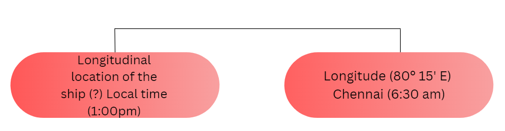
Question 14. When it is 6:30 am in Chennai, the time in New York is 8:13 pm on the previous day. What is the longitude of New York, if the longitude of Chennai is 80° 15′ E? 2. While on a voyage, a captain of a ship notices at 1:00 pm that the time being shown in the Chronometer is 6:30 pm. Which longitude is the ship passing through at that time?
Answer:
1. Determination of the longitude of New York:
When it is 6:30 am in Chennai, the time in New York is 8:13 pm on the previous day. Therefore, the difference in local time between Chennai and New York is (8:13 pm of the previous day 6:30 am) or [(24hrs 20hrs 13mins) + 6hrs 30mins] = 10hrs 17mins or 617mins.
Now, for every 4-minute time difference, the longitudinal difference is 1°.
∴ for a 617mins time difference, the longitudinal difference will be (617+ 4) = 154°15′.
So, the longitudinal difference between New York and Chennai is 154° 15′.
Now, since the local time of New York is behind the local time of Chennai, this implies that New York is located to the west of Chennai.
∴ the longitude of New York is (154°15′-80°15′) = 74° or 74° W.
2. Determination of the longitude of the place, the ship is passing through
The Chronometer runs based on Greenwich time. The time difference between Greenwich time and the unknown location of the ship is (6:30 pm – 1:00 pm) or (18hrs 30mins 13hrs) = 5hrs 30mins or 330mins.
Now, for every 4mins time difference, the longitudinal difference is 1″. Therefore, for the 330mins time difference, the longitudinal difference will be 3304 82°30′.
So, the longitudinal difference between Greenwich and the unknown location of the ship is 82° 30′.
As it is known that the time of the unknown location is behind that of Greenwich, the unknown place would be located to the west of Greenwich (0°). Therefore, the longitude of the unknown place would be (82°30′ -0°) 82° 30′ W.
Question 15. When the local time of Tripoli (13° 12’E) is 5 pm, the local time of an unknown city would be 7 am. What would be the longitude of this unknown city? When the local time of Katakana (88°30’E) is 11:30 am, the local time of Tokyo is 2:51 pm. What would be the longitude of Tokyo?
Answer:
1. Determination of the longitude of the unknown city:
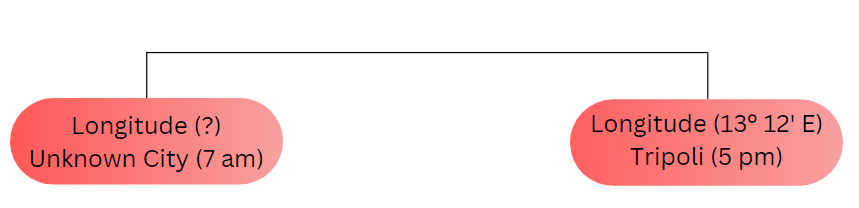
(5 pm 7 am) i.e., (17hrs 7hrs) = 10hrs or 600mins. Now, for every 4-minute time difference, the longitudinal difference is 1°.
Therefore, for a 600-minute time difference, the longitudinal difference will be 600 ÷ 4 = 150°.
As per the question, the time of the unknown city is behind that of Tripoli, so the unknown city would be located to the west of Tripoli. Therefore, the longitude of the unknown place would be
(150° 13°12′) = 136°48′ or 136° 48′ W.
2. Determination of the longitude of Tokyo:
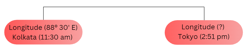
The difference in local time between Tokyo and Kolkata is- (2:51 pm – 11:30 am) i.e., (14hrs 51mins – 11hrs 30mins) = 3hrs or 21mins or 201mins. Now, for every 4mins time difference, the longitudinal difference is 1°
Therefore, for the 201mins time difference, the longitudinal difference will be 201÷ 4 = 50°15′.
As per the question, the time in Tokyo is ahead of Kolkata, so Tokyo would be located to the east of Kolkata (88° 30′ E). Therefore, the longitude of Tokyo would be (88° 30′ + 50° 15′) 138°45′ or 138° 45′ E.
Question 14. What would be the local time of Dhaka (90° E), when it is 6 am in Seoul (127° 06’E)?
Answer:
Determination of the local time of Dhaka:
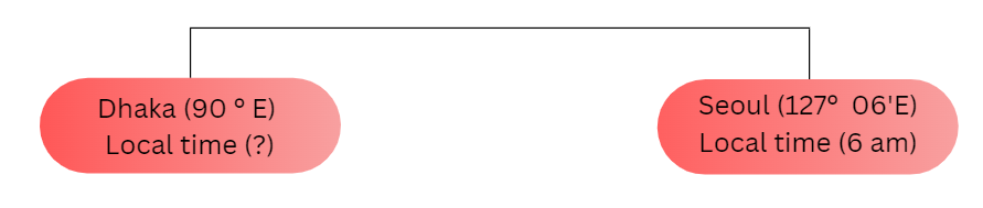
Both Seoul and Dhaka are located in the eastern hemisphere.
The longitudinal difference between Seoul and Dhaka is (127°06′-90°) = 37°06′.
So, the difference in time between Seoul and Dhaka would be
If, for every 1° longitudinal difference, the time difference experienced is 4 minutes. Therefore, for a 37° longitudinal difference, the time difference will be (37 × 4) = 148 minutes or 2hrs 28mins.
Again, for every 1′ longitudinal difference, the time difference experienced is 4 seconds. Therefore, for a 6′ longitudinal difference, the time difference will be (6 × 4) = 24 seconds.
So, the total time difference between Seoul and Dhaka becomes (2hrs 28mins + 24 seconds) = 2hrs 28mins 24 secs.
Since Dhaka is located to the west of Seoul, so the local time of Dhaka would be behind the local time of Seoul. Therefore, when it is 6 am in Seoul, the local time of Dhaka would be (6hrs – 2hrs 28mins 24 secs) = 3hrs 31mins 36 seconds or 3:31:36 am.
Question 15. Greenwich Time Signal was received by a place at 4:32 pm when it was noon at Greenwich. What is the longitude of that place, if the time taken by the signal to reach that place from Greenwich is calculated to be 2 minutes?
Answer:
Determination of the longitude of the unknown place:
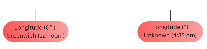
Greenwich Time Signal (2 minutes)Longitude (0°) Greenwich (noon)Longitude (?) Unknown place (4:32 pm)
The Greenwich Time Signal from Greenwich at noon was heard at 4:32 pm in an unknown place. The time taken by the signal to reach that place from Greenwich is 2 minutes.
Therefore, the signal should have reached that place at (4hrs 32mins – 2 mins) = 4hrs 30mins i.e., at 4:30 pm if the time lost in transmission is ignored.
So, the difference in local time between Greenwich and the unknown place is- (4:30 pm-12 noon) i.e., (16hrs 30mins – 12hrs) 4hrs 30mins or 270mins.
Now, for every 4-minute time difference, the longitudinal difference is 1°.
Therefore, for a 270-minute time difference, the longitudinal difference will be 270 ÷ 4 = 67° 30′. So, the longitudinal difference between Greenwich and the unknown place is 67° 30′.
As per the question, the time of the unknown place is ahead of Greenwich, so the unknown place would be located to the east of Greenwich (0°). Therefore, the longitude of the unknown place would be (0° + 67° 30′)= 67° 30′ or 67° 30’E
Question 16. What would be the local time, day, and date in Kolkata (88° 30′ E), while it is Wednesday at 8:30 pm on December 31, 2019, in New York (74° W)?
Answer: Determination of the local time, day, and date in Kolkata:
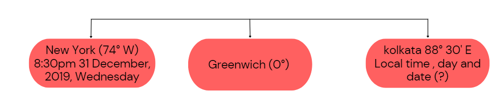
The longitudinal difference between New York and Kolkata is- (74° + 88° 30′) = 162° 30′.
Therefore, the difference in local time between New York and Kolkata would be—
Now, for 1° longitudinal difference is 4 minutes.
So, for the 162° longitudinal difference, the time difference will be 162 x 4 = 684 mins.
Again, for every l1 longitudinal difference time difference experienced is 4secs. Therefore, for a 30′ longitudinal difference time difference will be (30 x 4) = 120secs or 2mins.
So, the total time difference between New York and Kolkata becomes (648 + 2) = 650 mins or hrs 50mins.
As Kolkata is located to the east of New York, the local time of Kolkata will be ahead of New York. Therefore, while it is Wednesday 8:30 pm on 31 December 2019 in New York, the time in Kolkata would be (Wednesday 8:30 pm on 31 December 2019 + hrs 50mins) = Thursday 7:20 am on 1 January 2020.
Question 17. What would be the longitude of an unknown place that records noon, while it is 4:30 pm at Green¬wich? 2. What would be the local time in Madrid (3° 42′ W), when it is 8 pm in Vienna (16° 20’E)?
Answer:
Determination of the longitude of the unknown places:
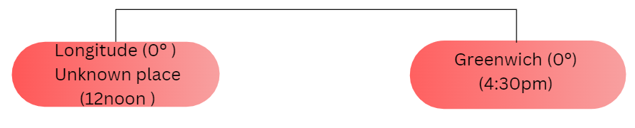
The difference in local time between Greenwich and the unknown place is— (4:30 pm – 12 noon) i.e., (16hrs 30mins – 12hrs) = 4hrs 30mins or 270mins.
Now, for every 4-minute time difference, the longitudinal difference is 1°.
Therefore, for a 270-minute time difference, the longitudinal difference will be 270÷4 = 67°30′.
So, the longitudinal difference between Greenwich and the unknown place is 67° 30′.
As per the question, the time of the unknown place is behind Greenwich, so the unknown place would be located to the west of Greenwich (0°). Therefore, the longitude of the unknown place would be (67° 30′ – 0°) = 67° 30′ or 67° 30′ W.
2. Determination of the local time in Madrid:
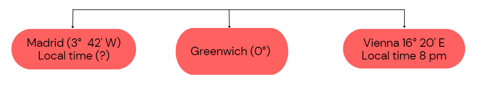
The longitudinal difference between Vienna and Madrid is— (16° 20′ + 3° 42′) = 20° 02’.
Now, for the 1° longitudinal difference, the time difference is 4mins.
So, for a 20° longitudinal difference, the time difference will be 20 x 4 = 80 mins or LHR 20 mins.
Therefore, for a 30′ longitudinal difference, the time difference will be (30 x 4) = 120 seconds or 2 minutes.
Again, for every 1′ longitudinal difference, the time difference experienced is 4secs.
Therefore, for 21 longitudinal differences, the time difference will be (2 x 4) = 8 secs.
So, the total time difference between Vienna and Madrid becomes (LHR 20mins + 8secs)= LHR 20mins 8secs. As Madrid is located to the west of Vienna, the local time of Madrid will be behind Vienna time.
Therefore, while it is 8 pm in Vienna, the time in Madrid would be (8 pm – 1 hr 20mins 8secs) = (20hrs – LHR 20mins 8secs) = 18hrs 39mins 52secs or 6:39:52 pm.
Finding Location Using Earth’s Grid System Class 9
Question 18. It takes 8 hours by flight to reach London from Kolkata. At what time the flight would reach London, if it takes off for London at 8 pm on 31 December 2019 as per 1ST time?
Answer:
Determination of the time and date when the flight will reach London:
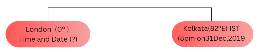
The longitudinal difference between Kolkata and London is (82°30′-0°) = 82°30
So, the difference in time between Kolkata and Greenwich would be
For every. 1° longitudinal difference, time difference experienced is 4 minutes.
∴ for 82° longitudinal difference, time difference will be (82 x 4) = 328 minutes.
Again, for every 1′ longitudinal difference, the time difference experienced is 4 seconds.
∴ For a 30′ longitudinal difference, the time difference will be (30 × 4) = 120 seconds or 2 minutes.
So, the total time difference between London and Kolkata becomes (328 + 2)m = 330 minutes or 5hrs 30mins.
Therefore, As London is located to the west of Kolkata, the time in London would be behind Kolkata.
When it is 8 pm on 31 December 2019 in Kolkata, the time in London would be (20hrs 5hrs 30mins) = 14:30 hours or 2:30 pm on the same day and date.
∴ Now, it takes 8 hours by flight to reach London from Kolkata.
So, the flight will reach at (14hrs 30mins + 8hrs) 22hrs 30mins or 10:30 pm on the same date and day i.e., December 31, 2019, according to GMT.
Question 19. When it is 6:32 am in Chennai, the time in New York is 8:15 pm the previous day. As Chennai is located at 80° 15′ E, where is New York located? 2. Why is the radio broadcast time difference between Kolkata (88° 30′ E) and Dhaka (89° E) 30 minutes even if the longitudinal difference between them is 30′?
Answer:
1. Determination of the longitude of New York:
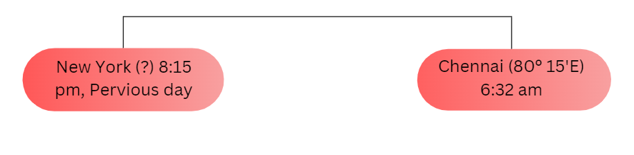
Now, for every 4-minute time difference, the longitudinal difference is 1°.
The local time of Chennai is 6:32 am and New York is 8:15 pm of the previous day.
So, the difference in local time between New York and Chennai is—
(Previous day 8:15 pm – 6:32 am) or [(24hrs – 20hrs 15minsj + 6hrs 32mins] = lOhrs 17mins or 617mins.
Now, for every 4-minute time difference, the longitudinal difference is 1°.
∴ For a 617-minute time difference, the longitudinal difference will be 617÷4 = 154°15′.
As per the question, the time of New York is behind that of Chennai, so New York would be located to the west of Chennai. Therefore, the longitude of New York would be (154° 15’ – 80° 15’) = 74° or 74° W.
2. Reasons for the difference in radio broadcast time between Kolkata and Dhaka: The longitudinal difference between Kolkata and Dhaka is 301. Accordingly, the time difference between them should be 2 minutes. But the difference in radio broadcasts is 30mins. The reason behind this is, that the time that the radio broadcast follows in Kolkata is according to the 1ST (82° 30′ E), and that in Dhaka is that of their standard meridian of 90° E.
The longitudinal difference (according to the standard meridians of India and Bangladesh) between Kolkata and Dhaka is (90° – 82° 30′) – 7° 30′.
So, the difference in time between Kolkata and Dhaka would be—
For every 1° longitudinal difference, the time difference experienced is 4 minutes.
Therefore, for the 7° longitudinal difference, the time difference will be (7×4) = 28 mins.
Again, for every 1′ longitudinal difference, the time difference experienced is 4 seconds.
Therefore, for a 30′ longitudinal difference, the time difference will be (30×4) = 120 seconds or 2 minutes. Therefore, the total time difference between Kolkata and Dhaka becomes (28 + 2) = 30 minutes.
Question 20. Determine the antipodal point for Kolkata (22° 30′ N, 88° 30′ E). 1 What was the day and date of the antipodal point of Kolkata, when it was Thursday, 1 March, 2012,8 am in Kolkata?
Answer:
Determination of the antipodal point of Kolkata: It is known that the longitudinal difference between a point and its antipode is always 180°.
So, if the longitude of Kolkata is 88° 30′ E, its antipode will be located at (180° – 88° 30′) = 91° 30′ W.
The latitude of the antipode will also be located in the opposite hemisphere. The latitude of the antipode point of Kolkata would be 22° 30′ S.
Therefore, the antipodal point of Kolkata is located at 22° 30′ S, 91° 30′ W.
Determination of the day, date, and time of Kolkata’s antipodal point:
The time difference between a point and its antipode is always 12 hours. So, if it was Thursday, March 1, 2012, at 8 am in Kolkata, the day, date, and time at its antipode were (Thursday, March 1, 2012, 8 am – 12 hours) = Wednesday, February 29, 2012, 8 pm. As 2012 was a leap year, February had 29 days.
WBBSE Chapter 2 Determination Of Location Of A Place Of The Earth’s Surface Short Answer Questions
Question 1. Why the Equator is known as the ‘great circle’?
Answer: The Equator Is Known As The ‘Great Circle’:
When the center of the circle that is drawn on the Earth’s surface and the center of the Earth is the same, then the circle becomes a ‘great circle’. There are several imaginary lines of latitude drawn over the Earth’s surface and out of those lines, the Equator is known as the great circle, because-
- The largest circle: The Equator is the largest circle. It is not possible to draw a circle larger than the Equator over the Earth’s surface.
- Same center with the Earth: The center of the Earth and that of the Equator lies at the same point.
- Divide the Earth equally: If the Earth is divided along the Equator, we get two halves One is the northern hemisphere and the other is the southern hemisphere. Centre of the Earth Equator (great circle)

Question 2. Introduce the important parallels of the Earth.
Answer: The important parallels of the Earth are-
1. Equator: The value of the Equator is 0°: Characteristics- The main characteristics of the Equation are-
- The equator is extended along the middle of the Earth. Its circumference is the largest and it has divided the Earth into two halves, so it is called the great circle.
- The latitude of a place is determined by the Equator.
2. Tropic of Cancer: Value of the Tropic of Characteristics- The main characteristics of the Tropic of Cancer are. It is the last limit of the northward movement of the Sun and delimits the northern boundary of Torrid Zone 2. Vertical sunrays fall on this latitude on 21 June.
3. Tropic of Capricorn: Value of the Tropic of Capricorn is Characteristics-The main characteristics of the Tropic of Capricorn are-
- It is the last limit of the southward movement of the Sun and delimits the southern limit of the Torrid Zone.
- On 22 December, vertical sunrays fall on this latitude.
4. Arctic Circle: The value of the Arctic Circle is 10 66 N. Characteristics- The main characteristics of the Arctic Circle are-
- The region between the Arctic Circle and the North Pole experiences 24 hours of the day from 21 June for 6 months at a stretch.
- It is the northern limit of the Temperate Zone. After this circle, the Frigid Zone begins.
5. Antarctic Circle: The value of the Antarctic 10 Circle is 66½º S. Characteristics-The main characteristics of the Antarctic Circle are-
- From 22 December the region between the Antarctic Circle and the South Pole experiences 24 hours of the day for 6 months at a stretch.
- It is the southern limit of the Temperate Zone. 3. After this circle, the Frigid Zone begins.
Question 3. What are the differences between latitude and parallels of latitude?
Answer: The differences between latitude and parallels of latitude are

Question 4. What are the differences between the axis and parallels of latitude?
Answer: The differences between the axis and parallels of latitude are-

Question 5. ‘The Equator is the most important latitude of the Earth. Why?
Answer: The Equator is the most important latitude of the Earth, because-
- Demarcation of hemispheres: The Equator is an east-west extended imaginary line passing through the middle of the Earth. It divides the Earth into two halves as northern hemisphere and the southern hemisphere.
- Calculation of latitude: The angular distance or latitude of a place on the Earth is measured from the Equator.
- Drawing of the parallels: All lines of latitude are drawn parallel to the Equator.
- Formation of the Torrid Zone: The sun’s rays fall vertically over the Equator and adjacent areas throughout the year. Thus, these regions form the Torrid Zone.
- Balance of the day and night: Length days and nights are of equal duration (12hrs) at the Equator, throughout the year. This is because the Equator lies in the middle of the Earth.
Question 6. Why does high temperature prevail in the torrid zone throughout the year?
Answer: High Temperature Prevails in The Torrid Zone Throughout The Year:-
The torrid zone extends between the Tropic of Cancer (232½°N) and the Tropic of Capricorn (23½º S). The apparent motion of the Sun is also restricted between these tropics. Starting from 22 December to 21 June, the Sun moves from the Tropic of Capricorn to the Tropic of Cancer, which is known as the apparent northward movement of the Sun.
Similarly from 21 June to 22 December, the Sun moves in the opposite direction which is known as the apparent southward movement of the Sun. Therefore, this region receives vertical rays of the Sun throughout the year, and this is why high temperature (25°C-35°C) prevails in this zone.
Question 7. What is meant by meridians of longitude? Discuss their properties and their uses.
Answer: Meridians Of Longitude:
Meridians of longitude: In geography, a meridian is the half of an imaginary great circle on the surface of the Earth, that ends at the geographical poles-the North Pole and the South Pole. It connects all the points of equal longitude. Each meridian is of equal length and is perpendicular to all the circles of latitude.

Properties and uses of meridians of longitude: The Properties and the uses of meridians of longitude are as follows-
- All the meridians of longitude are half circles.
- They are not parallel to each other.
- The distance between two consecutive meridians is the highest at the Equator and reduces gradually towards the Poles.
- All the meridians are of equal length.
- All places on the same meridian have the same longitudinal degree.
- The climatic characteristics of the places on the same meridian are not the same.
- The local time of various places lying on the same longitude is always the same.
Uses: The uses of the meridians of longitude are-
- The east-west position of a place can be determined concerning the Prime Meridian and the other longitudes as the standard of measure.
- The local time of any place on the surface of the Earth can be calculated based on which longitude it is positioned.
- Sometimes the boundary of any country or state is demarcated by the meridians. For example, some state boundaries of the USA.
Question 8. Explain with examples how the location of a place can be determined using the lines of latitude and longitude. How does the local time change with changing lines of longitude?
Answer: Determination of the location of a place with the help of parallels of latitude and meridians of longitude:
The location of any place on the Earth’s surface can be determined by using the lines of latitude and longitude. The parallels of latitude are full circles and run in an east-west direction. On the other hand, the meridians of longitude are half circles and run in a north-south direction. The combination of these two components forms a graticule that specifies the position of any place on the Earth.
This is why both parallels of latitude and meridians of longitude are shown on the map. To determine the exact location of a place, both are essential. For example, the location of Kolkata is 22° 30′ N and 88° 30′ E.

This statement explains the fact that Kolkata is located at the intersection point of 22°30′ N latitude and 88°30’E longitude.
Change of the local time with the changing lines of longitude: The lines of longitude of the Earth are half-circular lines that extend from north to south. Since the Earth rotates on its axis once every 24 hours, each longitude faces the Sun directly once every 24 hours. When the Sun is directly overhead any longitude, it is noon at that longitude.
The local time of that longitude is calculated concerning noon time at that longitude. Therefore, each line of longitude experiences noon only once every 24 hours and each longitude experiences it at different points in time. That is why local time changes with changes in the longitude.
Question 9. What is the International Date Line? Explain the significance of the line.
Answer: Internation Date Line:
The International Date Line is an imaginary line that follows the 180° longitude. However, it deviates from its original position near the Aleutian, Fiji, and the Chatham Islands. The International Date Line acts as a divider between the dates of the eastern and the western hemispheres. It is according to this line that the calendar date changes.
Significance of International Date Line: The Earth takes 24 hours or 1440 minutes to complete one rotation of 360°. Therefore, for every 1° difference in longitude, we experience a time difference of 4 minutes. Moreover, since the Earth rotates from west to east, the local time in the east is ahead of the local time in the west.
So, if the local time is followed on a world For example, both the 180° E and the 180° W are tour, a lot of discrepancies can arise regarding the date and time of the places. This creates a lot of confusion and inconvenience for business purposes.

Question 10. What do you mean by the Greenwich Mean Time?
Answer: Greenwich Mean Time:-
Greenwich Mean Time or GMT is the local time of the 0° Meridian passing through Greenwich near London. As different countries have different standard times, it becomes difficult to carry out international communications. To avoid this problem, Greenwich Mean Time is followed across the globe. Therefore, GMT is also known as Universal Time. Countries located to the east of the Prime
Question 11. How can we determine the longitude of a place?
Answer:
Determination Of Longitude Of A Place:-
The longitude of a place can easily be determined with the following references-
1. Concerning the time of any other longitude: We experience a time difference of 4 minutes, for a 1° longitudinal difference. So, if 4 minutes are added to the local time of a place, we get the next longitude, at an interval of 1°, towards the east of that place.
Similarly, if 4 minutes are subtracted from the local time of a place, we get the next longitude, at an interval of 1°, towards the west of that place. Therefore, if the local times of any two places are known along with the longitude of any one place, the longitude of the other place can be easily calculated.
2. Concerning GMT: GMT is the local time of the 0″ meridian passing through Greenwich near London. This is also known as Universal Time. So, if the time difference of a place from the GMT is known, the longitude can be easily calculated. Local time is ahead for places to the east and behind for the places to the west of Prime Meridian.
Example: The Indian Standard Time is ahead by 5 hours 30 minutes of GMT Therefore, the longitude of the Standard Meridian of India will be 82° 30’E.
Question 12. How was the International Date Line determined?
Answer: International Date Line:-
To use a global time zone system with an International Date Line, the day and date have to be separated at some point on the Earth by marking a terminal point. The suitable solution was provided in 1884 by the International Meridian Conference (IMC), held in Washington D.C., that representatives of 25 nations attended.
The IMC selected the 180° meridian as this terminal point. The imaginary line of the International Date Line was thus drawn that follows the 180° longitude mostly but deviates from its original position near the Aleutian Islands, Fiji, and Chatham Islands. The International Date Line acts as a dividing line between the dates of the eastern and western hemispheres. It is according to this line, that calendar dates are changed.
Question 13. Write a brief note on Prime Meridian and International Date Line.
Answer: Prime Meridian: The Prime Meridian is the imaginary line of longitude, considered to have a value of 0°, which passes through the Greenwich Observatory in London.
Characteristics: Special The special characteristics of Prime Meridian are-
- This line is directly opposite the 180° line of longitude or the International Date Line.
- This line divides the Earth into the eastern and western hemispheres.
- As this line passes through the Royal Observatory in Greenwich, London, it is called the Greenwich Line.
- The location and local time of any place is determined with reference. To this line.
- The line is important to know the distance of a place from the Prime Meridian in an east-west direction.
International Date Line: The International Date Line is an imaginary line that follows the 180° longitude mostly but deviates from its original position over the landmasses.

Special characteristics: The special characteristics of the International Date Line are-
- A calendar date starts and ends at this line.
- When anyone crosses the International Date Line from east to west, he subtracts one day from his calendar.
- Similarly, he has to add one day when he crosses the line from west to east.
Question 14. Why do some countries have more than one standard time?
Answer: Some Countries Have More Than One Standard Time:-
Places situated on different meridians have different local times. Several meridians pass through every country. If all their local times are considered then the proper functioning of the administration and business gets hindered.
So, to avoid such a situation, the local time of the central meridian is taken as the standard time for the entire country. However, countries with a vast east-west extension face problems regarding the time difference between their eastern and western parts.
Too great a time difference between the extreme east and the extreme west causes inconvenience and confusion. Therefore, these countries are divided into several time zones, each having its own standard time. For example, Russia is divided into 11 time zones.
Question 15. What do you mean by Daylight Saving Time or DST?
Answer: Daylight Saving Time Or DST:-
In countries of high latitudes, the difference between the duration of day and night is quite huge with the changing seasons. Therefore, many countries started using Daylight Saving Time or DST (first proposed by Benjamin Franklin in 1784) to make better use of natural daylight in the evenings. Many use it to reduce the amount of energy needed for artificial lighting during the evening hours.
Many countries in the northern hemisphere, like the USA, Canada, Central America, Europe, Asia, and North Africa use DST. Similarly, many countries in the southern hemisphere, like Australia, New Zealand, countries of South America, and South Africa also use DST. In the northern hemisphere, from 21 March the countries advance the clock timing by 1-2 hours. Likewise from 23 September, the clock is set back by 2 hours to make the best use of the daylight.
Question 16. Differentiate between parallels of latitude and meridians of longitude.
Answer: The differences between parallels of latitude and meridians of longitude are Points of difference-

Question 17. What are the differences between longitude and meridians of longitude?
Answer: The differences between longitude and meridians of longitude are-

Question 18. What are the differences between local time and standard time?
Answer: The differences between local time and standard time are

Question 18. How Local time Practical usage of this is not that This is used primarily for convenience significance of administration and governance are longitude and time interrelated.
Answer: Longitude and time are interrelated in the following ways-
Determination of midday and local time: Longitude helps in determining the time of midday in any area. The time of midday helps in determining the rest of the time of the day because every longitude of the Earth faces the Sun at least once in 24 hours.
The difference between each 1° longitude and time is 4 minutes: The Earth takes 24 hours to complete a rotation. So, the Earth rotates 360° in 24 hours. That means, to complete a 1° rotation, Earth takes 4 minutes.
The regions of the East are always ahead in time of those of the West: The Earth rotates from west to east, so the places in the East experience sunrise and sunset earlier than the places in the West. So, the places located in the east are ahead in time of the places located in the west.
Question 19. Write three characteristics of antipodes
Answer: Diametrically opposite places on the Earth’s surface are antipodes to each other. Three characteristics of antipodes are-
- The latitudinal value of a place and its antipodes always remain the same, but the hemispheres are different.
- The longitudinal difference between any place on the Earth and its antipodes is always 180°.
- If a place lies on the Equator, its antipodes will always lie on the Equator, and antipodes of a place that lies at 180° longitude, will always lie at 0° longitude.
Question 20. How will you reckon the antipodes of a place based on longitude?
Answer: Reckon The Antipodes Of A Place based on Longitude:-
Two ends of any diameter of the Earth are antipodes to one another. So, the reckoning of the antipodes is possible if the longitude of a place is known. As a place and its antipodes lie on diametrically opposite sides of the Earth, the longitudinal difference between a place and its antipodes will always be 180°.
As an example, the longitude of Katakana is 88°30′ East. So, the longitude of its antipodes will be (180° – 88°30′ E) it’s = 91°30′ West (Refer to Figure ‘Antipodal position’ of question number 11 of this section).
Question 21. ‘The difference of time between a place and its antipodes is 12 hours.” Explain.
Answer: Refer to the second part of question number 9 from the ‘Numerical Problems’ section.
Question 22. Determine the difference between a place and its antipodes.
Answer: Difference Between A Place And Its Antipodes:-
The differences between a place and its antipodes are that a place and its antipodes are always situated at opposite longitudes. The longitudinal difference between a place and its antipodes is always 180°.
The time difference between a place and its antipodes is always 12 hours. A place and its antipodal place always lie in opposite hemispheres. A place and its antipodes always lie at the opposite points of the diameter that passes through the center of the Earth.
Question 23. Why is the 180° longitude known as the International Date Line?
Answer: 180° Longitude Is Known As The International Date Line:-
180° longitude is known as the International Date Line, because- 180° longitude is considered the starting and ending point of the dates and times on the Earth. Since 180° longitude passes mostly over the water bodies, the time zones of the continents are not affected. When the 180° longitudinal line is crossed from the western side of the Greenwich, the international date is added by a day. Again, when the 180° longitudinal line is crossed from the eastern side of Greenwich, the international date is subtracted by a day.
Question 24. Why does the International Date Line not follow the 180° line of longitude throughout?
Answer: The International Date Line almost together also forms a great circle. Coincides with the 180° longitude but is not completely the same line. It zigzags to avoid crossing over any landmass. In the northern hemisphere, the International Date Line is displaced eastwards to avoid the Wrangell Island as well as the Chukchi Peninsula on the Russian mainland and then deviates west to avoid the Bering Sea and also deviates almost 7° to avoid the Aleutian Islands.
In the southern hemisphere, the International Date Line deviates almost 11° to avoid Fiji, Chatham, and other islands. This makes it convenient for all the people of Siberia to follow the standard time of Siberia, the people of the Aleutian Islands to follow the Pacific Standard Time of the USA and Fiji, and the people of Tonga and Chatham to follow the standard time of New Zealand and avoid any kind of confusion.
Question 25. What is meant by a great circle?
Answer: Great Circle:-
When the center of a circle is drawn on the surface of a sphere and the center of the sphere is the same then the circle is known as a great circle.
Characteristics: The main characteristics of the Great Circle are-
- It is not possible to draw a circle on the surface of a sphere greater than the great circle.
- The center of the great circle coincides with the center of the sphere.
- The great circle divides the Earth into two equal hemispheres.
Example: Amongst the parallels, the Equator is the only great circle. The two opposite longitudes
Question 26. Write the differences between the Equator and the Prime Meridian.
Answer: The differences between the Equator and the Prime Meridian are

Question 27. ‘A tourist experiences a change of time as he goes round the Earth along the Equator and observes a change of climate as he goes from the Equator to the Poles along the meridian’-Briefly explain the reason.
Answer: Keeping the Sun in front, the Earth is rotating on its axis from west to east direction, and the time taken by the Earth to complete one rotation is about 24 hours or 1 day. When a tourist goes around the Earth along the Equator, On the other hand, the intensity of effective solar radiation gradually decreases from the Equator to the Poles. So, the climate gets colder towards the Poles. That is why the change of climate is observed from the Equator to the Poles along the meridian.
WBBSE Chapter 2 Determination Of Location Of A Place on the Earth’s Surface Short Answer Questions
Question 1. What is meant by parallels of latitude?
Answer: Parallels Of Latitude:
The imaginary lines drawn over the Earth, which run parallel to the Equator are known as parallels of latitude. They are also called lines of latitude. These lines join all places having the same latitudinal value or angular distance from the Equator. For example, the Tropic of Cancer (23½º N).
Question 2. What are the properties of the lines of latitude?
Answer: The properties of the lines of latitudes are-
- All the lines of latitude are full circles and run parallel to each other.
- They all run in an east-west direction. As the latitudinal value increases, the circumference of the circles of latitudes decreases. The local time of the places lying on the same latitude is always different.
Question 3. What is the Equator?
Answer: Equator:
The Equator is an imaginary east-west line encircling the Earth midway between the North and South Poles. The Equator is the 0° latitude. It divides the Earth into two halves called the Northern Hemisphere and the Southern Hemisphere. The average circumference of the Equator is 40,000km.
Question 4. What is meant by equatorial plane?
Answer: Equatorial Plane:
The imaginary plane that passes through the Equator and cuts the Earth into two halves is called the equatorial plane. The center of the Earth lies on this plane and so, the angular value of this plane is 0°. It is perpendicular to the Earth’s axis.
Question 5. What are the Arctic Circle and Antarctic Circle?
Answer: Arctic Circle And Antarctic Circle:
Arctic Circle is the parallel of latitude that runs along 66½º north of the Equator, whereas, Antarctic Circle is the parallel of latitude that runs along 66½º south of the Equator. The region beyond the Arctic and the Antarctic Circles experiences 6 months of complete daylight and 6 months of complete darkness throughout the year.
Question 6. What is meant by latitude?
Answer: Latitude:
The angular distance of a place, north or south of the Equator, usually measured in degrees is known as latitude. All the places having the same latitudinal value, joined by a single line, form the parallel. For example, the latitude of Kolkata is 22° 30′ N.
Question 7. What is meant by angular distance?
Answer: Angular Distance:
An angle whose apex is at the center of the spherical Earth and whose legs are radii intersecting the circle in two distinct points, thereby subtending an arc between those two points is known as the angular distance. The unit used to measure the angular distance is degrees, minutes, and seconds as it is conceptually identical to an angle.
Question 8. What is a Sextant?
Answer: Sextant:
A Sextant is an instrument used to determine the angle between a celestial object and the horizon (this angle is also known as the object’s altitude). The instrument has an in-built telescope and helps in determining the latitude of a place.
Question 9. What is meant by the northern and the southern latitudes?
Answer: Northern And The Southern Latitudes:
The latitudes can be delineated into two types based on which hemisphere it is located in. They are-
Northern latitudes: Latitudes located to the north of the Equator are known as northern latitudes. So, all the latitudes from 1° to 90° in the northern hemisphere will be marked as northern latitudes. These are denoted by the letter ‘N’.
Southern latitudes: Latitudes located to the south of the Equator are known as southern latitudes. So, all the latitudes from 1° to 90° in the southern hemisphere are the southern latitudes. These are denoted by the letter ‘S’.
Question 10. What is meant by 22°30′ N latitude of Kolkata?
Answer: 22°30′ N Latitude Of Kolkata:
Latitude is the angular distance of a place from the center of the Earth either north or south of the Equator on the equatorial plane. Latitudes at the north and south of the equatorial plane are known as northern and southern latitudes respectively. Now, the latitude of Kolkata is 22°30’N, which means Kolkata is located at an angular distance of 22°30′ north of the Equator.
Question 11. What is the difference between a great circle and a small circle?
Answer: Difference Between A Great Circle And A Small Circle:
When the center of a circle is drawn on the surface of a sphere and the center of the Determination of Location of a Place on the Earth’s Surface sphere are the same, then the circle is called a great circle.
The other circles that can be drawn on the surface of a sphere are called small circles. A great circle is different from small circles because small circles do not share the same center as the sphere. For example, the Equator(0°) is a great circle whereas, both the Tropics (23½º) are small circles.
Question 12. What is meant by meridian?
Answer: Meridian:
In geography, a meridian is the half of an imaginary great circle on the surface of the Earth, that ends at the geographical poles- the North Pole and the South Pole. It. Connects all the points of equal longitude. Each meridian is of equal length and is perpendicular to all the circles of latitude.
Question 13. What are the properties of lines of longitude?
Answer: Properties Of Lines Of Longitude:
The properties of lines of longitude are- All the longitudes are half circles. The longitudes are of equal length. The longitudes run in a north-south direction. The local time of the places lying on the same longitude is always the same.
Question 14. What is the Prime Meridian?
Answer: Prime Meridian:
Prime Meridian is the imaginary line drawn from the North Pole to the South Pole that passes and through Greenwich and is designated as the 0° longitude. All other longitudes are measured from this line. The Greenwich Meridian divides the Earth into two equal halves-the eastern and western hemispheres.
Question 15. What is meant by longitude?
Answer: Longitude:
The angular distance of a place, east or west of the Greenwich Meridian, usually measured in degrees is known as longitude. All the places having the same longitudinal value, if joined by a single line, form the meridian. For example, the longitude of Kolkata is 88° 30′ E.
Question 16. What is local time?
Answer: Local Time:
The time of a place that is determined according to noon time or when the Sun is directly overhead the meridian passing through that place, is called the local time of that place. Local time is also determined using the angle of elevation of the Sun at that place.
Question 17. What is standard time?
Answer: Standard Time:
The time of any country that is standardized according to the local time at its Standard Meridian or the longitude passing through the middle of that country, is called standard time. The time of a country can be determined from this.
Question 18. What is meant by antipode?
Answer: Antipode:
The antipode of a point is the point on the Earth’s surface that is diametrically opposite to it. The two points which are antipodal to one another can be connected by a straight line running through the center of the Earth.
Question 19. What is the International Date Line?
Answer: International Date Line:
The International Date Line is an imaginary line that mostly follows the 180° longitude but deviates from its position near the Aleutian Islands, Fiji, and the Chatham Islands. The International Date Line acts as a dividing line between the dates of the eastern and western hemispheres. According to this line, the calendar dates are changed.
Question 20. What is a Chronometer?
Answer: Chronometer:
Chronometer is a precise and accurate time-keeping device, used to determine the longitude at sea. In 1735, John Harrison built the first Chronometer, which he improved with many innovations, over the next thirty years before submitting it for examination. The most complete international collection of Chronometers, including the Harrison’s, is at the Royal Observatory, in London, England.
Question 21. At which places does the International Date Line deviate from the 180° longitude?
Answer: The International Date Line is not straight. It moves in a zigzag manner to avoid crossing through any landmass. In the northern hemisphere, the International Date Line is displaced eastwards to avoid Wrangel Island and then deviates almost 7° west near the Bering Sea to avoid the Aleutian Islands. In the southern hemisphere, the International Date Line deviates almost 11° to avoid Fiji, Chatham, and other islands.
Question 22. What is meant by graticule?
Answer: Graticule:
A graticule is a network or web of lines representing the Earth’s parallels of latitude and meridians of longitude, on which maps are drawn. The combination of these two components specifies the position of any place on Earth. However, it does not consider the altitude or depth of a place.
Question 23. What is the Standard Meridian for India?
Answer: Standard Meridian For India:
India, lying in the eastern hemisphere, has a vast longitudinal extension i.e., from 68°07′ E to 97°25′ E. The 82½ E longitude is taken as the Standard Meridian for the country and the local time of this meridian is considered the standard time for the entire India. It is known as the Indian Standard Time (IST). The Indian Standard Meridian (ISM) passes through the city of Allahabad. Therefore, the local time of Allahabad is taken as the standard time for India.
Question 24. What is a sundial?
Answer: Sundial:
Sundial is the earliest timekeeping device, that indicates the time of a day by the position of the shadow of some object that changes due to the apparent movement of the Sun. As the day advances, the Sun moves across the sky. As a result, the shadow of the object also moves accordingly and indicates the passage of time. The flat surface of the sundial is called the dial plate, which is generally made out of materials like wood, stone, metal, and others.
Question 25. Why is standard time more useful for a country than local time?
Answer: Standard Time More Useful For A Country Than Local Time:
Several meridians pass through every country. If their local times are considered then the proper functioning of the national services like railways, airways, and postal departments in the country gets hindered. So, a country considers the time of its central meridian or the standard meridian to calculate the standard time for the entire country. This is why standard time is more useful for a country than local time.
Question 26. Why does the local time change with the change of meridian?
Answer: Local Time Change With The Change Of Meridian:
The local time changes with the change of meridian, because because-The Earth takes 24 hours to complete one rotation on its axis. So, each meridian of the Earth faces the Sun once every 24 hours.
Midday occurs on a meridian when sunrays fall vertically on that meridian. The local time of that meridian is determined according to this time. So, midday occurs once every 24 hours in each meridian. So, the local time changes with the change of the meridian.
Question 27. What are am and pm?
Answer: Am And PM: The local time of any place between midnight or midnight and midday or noon is called ante meridian or am, while the local time of any place from midday or noon to midnight or midnight is called post meridian or pm.
Question 28. What are GMT and IST?
Answer: GMT And IST: GMT or Greenwich Mean Time is the local time of the Prime Meridian (0°) that passes through the Greenwich Royal Astronomical Observatory. In the year 1884, by an international agreement, the local time of the Prime Meridian was selected as the standard time for the whole world. So, it is also called World Standard Time.
IST is Indian Standard Time. The central meridian of India is 82°30′ East that passes through Mirzapur of Allahabad in Uttar Pradesh. The local time of 82°30′ East meridian is granted as the local time of all the places in India.
Question 29. What is the time zone?
Answer: Time Zone: Countries with great east-west longitudinal extensions have several time zones. Each zone has its own standard time. Thus Russia has been divided into 11 time zones.
WBBSE Chapter 2 Determination Of Location Of A Place Of The Earth’s Surface Fill In The Blanks
1. The lines of Latitude run in an east-west direction.
2. The latitudinal value of the Tropic of Cancer is 23½º
3. The only great circle among the parallels of latitude is the Equator.
4. The lines of latitude are also known as the parallels
5. The expanse between the 90° and the 6634° latitudes in both hemispheres is known as the Frigid Zone
6. The heavenly body that helps to determine latitude at the North Pole is the Pole star
7. As the angular distance of a place, north or south of the Equator increases, the circumference of the latitude decreases
8. The equator divides the Earth into two halves.
9. The latitudes are in shape Circular.
10. The latitudes between the Equator and 30° in both hemispheres are known as Low latitudes.
11. The instrument used to calculate the latitude of any place is the Latitude of the Antarctic Circle Sextant
12. The latitude of the Antarctic Circle is 66½º S
13. The International Date Line coincides with the 180º Longitude
14. The location of any place on the surface of the Earth can be determined by the intersection point of the longitude and the latitude of that place.
15. With every 15° longitudinal difference, there is a time difference of 60º minutes.
16. The prime meridian is also referred to as the International Meridian.
17. The lines of longitude run in a north-south direction.
18. The number of time zones that Russia is divided into is 11
19. 82º is referred to as the standard meridian of India.
20. The longitudes are semi-circular in shape.
21. The standard time at any place in the world is determined concerning the green which meantime
22. All the longitudes are equal in length.
23. A time difference of 4 minutes is observed for a longitudinal difference of 1 º.
24. The angular value of the Prime Meridian is 0º
25. The longitudinal difference between 90° W and 5° E is 95º
26. The standard meridian of the westernmost time zone of the USA is 120ºW
27. The antipode of the 180° longitude lies on 0º(prime meridian)
28. The line from which a new date starts in both the eastern and western hemispheres is the International Date Line
29. Each meridian cuts all parallels at Right angles
30. Before and after the time of midday is known as am and pm respectively.
31. According to the various positions of the Sun in the sky, the calculation of local time is called runtime.
32. The time difference between a place and its antipode is 12 hours.
WBBSE Chapter 2 Determination Of Location Of A Place On The Earth’s Surface Write True Or False
1. The Equator is an example of a great circle. True
2. The angle of elevation of the Pole Star in the southern hemisphere is 90°. False
3. The local time of a place is calculated with the help of its latitude. False
4. A chronometer is used to measure the latitude of a place. False
5. The 66½º N latitude is also known as the Antarctic Circle. False
6. All the lines of latitude intersect the lines of longitude horizontally. False
7. The angular distance of a place north or south of the Equator is the same for all the places located on the same latitude. True
8. On 21 March, all the places on Earth experience 12 hours of the day and 12 hours of night. True
9. The angle of elevation of the Pole Star is measured to be 90° from any place in the northern hemisphere. False
10. Hadley’s Octant is used to determine the direction in the southern hemisphere. True
11. The Equator passes through Brazil. True
12. 6°45’S is the southernmost latitude of India. True
13. The climatic characteristics of various places lying on the same latitude are alike. True
14. The latitudes between 30°-60° are called low latitude. False
15. Time is determined with the help of Sextant. False
16. Latitudinal values of all the places lying on a parallel are the same. True
17. All parallels are full circles. True
18. India lies in the southern hemisphere. False
19. The angle of elevation of the Pole Star in the southern hemisphere is measured by the Transit Theodolite. False
20. The Pole Star can be seen above the head at the North Pole. True
21. When it is 7 am in Kolkata, it is midnight at its antipode. False
22. The International Date Line is not straight. True
23. The 0° longitude is known as the Prime Meridian. True
24. A time difference of 24 hours is experienced with 180° of longitudinal difference. False
25. When it is daytime at a place, its antipode experiences night. True
26. The antipodal position of a place located on the Prime Meridian will be at 180° longitude True
27. The International Date Line is drawn on the waterbodies only. True
28. In the eastern hemisphere, units of time are added, with an increase in longitudinal value. True
29. Local time is calculated based on the highest position of the Sun on a particular meridian. True
30. The climatic characteristics change with a change in longitude. False
31. The Prime Meridian is also known as the Greenwich Meridian. True
32. Canada has 5 standard meridians. False
33. When the Sun is at its highest elevation on a particular meridian, it is considered to be noon at that place. True
34. The longitudinal difference between two places in the same hemisphere is calculated by adding up their longitudinal values. False
35. In the western hemisphere, time decreases with an increase in longitudinal value. True
36. Time in India is behind that of Greenwich Mean Time. False
37. The local time of Delhi is considered the standard time of India. False
38. The International Date Line passes through the Strait of Malacca. True
39. Longitudes are also known as meridians. True
40. Each meridian cuts each parallel at a right angle. True
41. All the meridians are of equal length. True
42. Calculation of Greenwich Mean Time is determined by Chronometer. True
43. Greenwich Time is called local time. False
44. Prime Meridian is a half circle. True
45. Meridians are parallel to each other. False
46. Another name for Prime Meridian is the International Date Line. False
47. All places on the same meridian have the same local time. True
48. Climate will change if you move along the Prime Meridian. True
49. Both 180° E and 180° W meridian the same line. True
Chapter 2 Determination Of Location Of A Place Of The Earth’s Surface Match The Left Column With The Right Column
1.

Answer 1-D ,2-B, 3-A, 4-C
2.

Answer 1-C ,2-A, 3-D, 4-B
1.

Answer 1-B ,2-C, 3-D, 4-A
2.

Answer 1-A ,2-C, 3-D, 4-B
Chapter 2 Determination Of Location Of A Place Of The Earth’s Surface Answer In One Or Two Words
Question 1. What is the latitudinal value of the Arctic Circle?
Answer: 66½º N.
Question 2. What is the latitudinal value of the Tropic of Capricorn?
Answer: 232° S.
Question 3. What is the other name of lines of latitude?
Answer: Parallels of latitude.
Question 4. What is 90° N also known as?
Answer: North Pole.
Question 5. What is 90° S also known as?
Answer: South Pole.
Question 6. Name the latitude that is located at an equal distance from either of the poles.
Answer: The Equator.
Question 7. Name the imaginary plane that passes through the Equator and is perpendicular to the Earth’s axis.
Answer: Equatorial plane.
Question 8. Which line is the reference line to determine the latitude of a place?
Answer: The Equator.
Question 9. What is the other name of the North Pole?
Answer: Arctic.
Question 10. What is the other name of the South Pole?
Answer: Antarctic.
Question 11. What is the meaning of sextant?
Answer: 1/6 of a circle (60°).
Question 12. How many lines of latitude are there in the north of the Equator at an interval of 1° including the Equator?
Answer: 90.
Question 13. Which line does not form an angle with the equatorial plane or center of the Earth?
Answer: The Equator.
Question 14. What is Transit Theodolite?
Answer: An instrument to measure the angular distance.
Question 15. What are lines of longitude also known as?
Answer: Meridians of longitude.
Question 16. What is the Prime Meridian also known as?
Answer: Greenwich Meridian.
Question 17. What is the angular distance of a place, east or west of the Prime Meridian known as?
Answer: Longitude.
Question 18. Which natural object can be used to calculate time?
Answer: Sun.
Question 19. What is the other name of Local Mean Time?
Answer: Solar time.
Question 20. Who invented the Chronometer?
Answer: John Harrison.
Question 21. What is the linear distance between two lines of longitude, at an interval of 1°, along the Equator?
Answer: 111.3 km.
Question 22. What is located at the antipode of the Prime Meridian?
Answer: 180° longitude or the International Date Line.
Question 23. What is the time difference between 1ST and GMT?
Answer: 5 hours and 30 minutes.
Question 24. What is the time difference between a place and its antipode?
Answer: 12 hours.
Question 25. What is the longitudinal difference between a place and its antipode?
Answer: 180º.
Question 26. How much time is gained while crossing the International Date Line from the Western Hemisphere?
Answer: 24 hours or 1 day.
Question 27. When and where was the International Meridian Conference held?
Answer: October 1884 in Washington DC.
Question 28. Which state of India experiences sunrise first?
Answer: Arunachal Pradesh.
Question 29. Which meridian follows the International Date Line?
Answer: 180° meridian.
Question 30. What is the antipodal latitude of 30° N latitude?
Answer: 30° S.
Question 31. What is the time difference for the 15° meridian difference?
Answer: 60 minutes or 1 hour
Question 32. What is the satellite system for the determination of elevation and location on the Earth’s surface called?
Answer: Global Positioning System (GPS).
Question 33. Which country has the maximum number of standard meridians?
Answer: Russia (11).


 Question 21. What is hydration?