WBBSE Class 6 Geography Chapter 3 Where You Are Notes

WBBSE Class 6 Geography Chapter 3 Where You Are Notes

1. A globe is a sphere-shaped small model of the Earth.

2. The imaginary line that connects the two poles of the Earth through its centre is called the Earth’s axis. The length of this axis is 12,714 km.

3. The northern limit and southern limit of the axis of the Earth are known as the North Pole and the South Pole respectively.

4. The imaginary circular line lying equidistant from the poles and running along the surface of the Earth around its centre in an east-west direction is called the Equator.

5. The northern half of the Earth from the Equator is the northern hemisphere.

WBBSE Class 6 Geography Chapter 3 Where You Are Notes

6. The southern half of the Earth from; the Equator is the southern hemisphere.

Read and Learn More WBBSE Class 6 Geography Notes

7. The angular distance of a place—north or south from the Equator, measured in degrees from the centre of the Earth, is known as latitude.

8. The imaginary circular lines parallel to the Equator and each other running in an east-west direction are known as parallels of latitude.

9. The parallel of latitude to the north of the Equator with an angular value of 23y2°N is known as the Tropic of Cancer.

10. The parallel of latitude to the north of the Equator with an angular value of 66%°N is known as the Arctic Circle.

11. The 90°N polar point in the northern hemisphere is called the North Pole.

WBBSE Solutions For Class 6 Geography WBBSE Solutions For Class 6 History WBBSE Solutions For Class 6 Maths
WBBSE Class 6 Geography Notes WBBSE Class 6 History Notes
WBBSE Class 6 Geography Multiple Choice Questions WBBSE Class 6 History MCQs WBBSE Notes For Class 6 School Science


12. The parallel of latitude in the southern hemisphere with an angular value of 231/2°S is called the Tropic of Capricorn.

13. The parallel of latitude in the southern hemisphere with an angular value of 66V4°S is known as the Antarctic Circle.

14. The 90°S polar point in the southern hemisphere is known as the South Pole.

15. The plane containing the Equator which divides the Earth into two equal halves is called the Equatorial plane.

WBBSE Class 6 Parallels of Latitude Notes

16. The elliptical path on which the Earth revolves around the Sun is known as the Earth’s orbit.

17. The plane on which the Earth constantly revolves around the Sun in its own orbit is called the orbital plane.

18. The angular distance of a place, east or west from the Prime Meridian, measured in degrees from the centre of the Earth is known as longitude.

19. The imaginary semi-circular lines connecting the two poles and running in a north-south direction are known as the meridians of longitude.

20. The meridian of longitude passing through the Royal Observatory at Greenwich having an angular value of 0° is known as the Prime Meridian.

21. The diametrically opposite meridian to the Prime Meridian common to both east longitude and west longitude, is known as the 180° meridian. The International Date Line mostly follows this meridian.

22. The Prime Meridian and 180° meridian jointly divide the Earth into two halves. The one located in the east is known as the eastern hemisphere, while the one located in the west is called the western hemisphere.

23. A Great Circle is any circle that is drawn on the Earth’s surface, sharing the same centre as that of the Earth itself. The Equator is a Great Circle.

WBBSE Class 6 Geography Chapter 3 Where You Are MCQs

WBBSE Class 6 Geography Chapter 3 Where You Are Multiple Choice Questions

Question 1. The Europeans first drew up a map of the world in the—

  1. Sixteenth century
  2. Fifteenth-century
  3. Twenty-first century

Answer: 1. Sixteenth century

Question 2. The longest line of latitude is the—

  1. Antarctic circle
  2. Equator
  3. Arctic circle

Answer: 2. Equator

Question 3. The angle of the equator from the centre of the earth is—

  1. 66/2°
  2. 2334°

Answer: 1. 0°

Question 4. The most important line of latitude is the—

  1. Tropic of cancer
  2. Tropic of Capricorn
  3. Equator

Answer: 3. Equator

Read and Learn More WBBSE Class 6 Geography Multiple Choice Questions

Question 5. The northern and southern hemispheres are determined by the—

  1. Prime meridian
  2. Lines of latitude
  3. Equator

Answer: 3. Equator

WBBSE Class 6 Geography Chapter 3 Where You Are MCQs

Question 6. As one moves from the equator to the poles, the degree of the latitudes—

  1. Increases
  2. Decreases
  3. Stays the same

Answer: 1. Increases

Question 7. The imaginary lines running around the earth from east to west are called the—

  1. Parallel of latitude
  2. Meridians of longitude
  3. Grids

Answer: 1. Parallel latitude

Question 8. The lines of latitude extend from—

  1. East to west
  2. North to south
  3. East to north

Answer: 1. East to west

Question 9. According to their shape, the lines of latitude are—

  1. Complete circles
  2. Half circles
  3. Arcs

Answer: 1. Complete circles

Question 10. The total number of lines of latitude on the earth is—

  1. 90
  2. 179
  3. 88

Answer: 2. 179

Question 11. The 2334° n line of latitude is called the—

  1. Tropic of cancer
  2. Tropic of Capricorn
  3. Equator

Answer: 1. Tropic of cancer

Question 12. The tropic of cancer is the line of latitude with an angular measurement of—

  1. 231/2°N
  2. 66°S
  3. 90°N

Answer: 1. 231/2°N

Question 13. The 6620s line of latitude is called the—

  1. Arctic circle
  2. Tropic of Capricorn
  3. Antarctic Circle

Answer: 3. Tropic of Capricorn

Question 14. The equatorial plane is at an angle of—

  1. 90° To the earth’s axis
  2. 0° To the earth’s axis
  3. 50° To the earth’s axis

Answer: 1. 90° To the earth’s axis

Question 15. The path along which the earth travels around the sun is called—

  1. Equator
  2. Great circle
  3. Orbit

Answer: 3. Orbit

Question 16. The line of latitude that runs through India is the—

  1. Equator
  2. Tropic of cancer
  3. Tropic of Capricorn

Answer: 2. Tropic of cancer

Question 17. The imaginary half-circles connecting the north pole and the south pole are called—

  1. Lines of latitude
  2. Lines of longitude
  3. Equator

Answer: 2. Lines of longitude

Question 18. The lines of longitude are—

  1. Parallel to each other
  2. Not parallel to each other
  3. Unequal to each other

Answer: 2. Not parallel to each other

Question 19. With reference to lines of longitude, India falls in the—

  1. Eastern hemisphere
  2. Western hemisphere
  3. Northern hemisphere

Answer: 1. Eastern hemisphere

Question 20. The value of the prime meridian is—

  1. 90°
  2. 50°

Answer: 2. 0°

Question 21. The prime meridian was established in the year—

  1. 1880
  2. 1884
  3. 1980

Answer: 2. 1884

Question 22. The total number of lines of longitude is—

  1. 178
  2. 360
  3. 88

Answer: 2. 360

Question 23. The unit to measure the value of latitudes and longitudes is—

  1. Kilometre
  2. Degree
  3. Mile

Answer: 2. Degree

Question 24. At the equator, the distance between the meridians is—

  1. Less than at other latitudes
  2. More than at other latitudes
  3. The same with other latitudes

Answer: 2. More than at other latitudes

Question 25. The continent entirely located in the eastern hemisphere is—

  1. North America
  2. Australia
  3. Africa

Answer: 2. Australia

WBBSE Class 6 Geography Chapter 2 Is The Earth Round Notes

WBBSE Class 6 Geography Chapter 2 Is the Earth Round Introduction

1. A part of the circumference of a circle is called an arc.

2. The radius of a circle is the distance from the center of a circle to any point in the circumference.

3. A round solid figure that has three dimensions and is shaped like a ball is called a sphere. For example, the Earth is a sphere.

4. The distance from the centre of a sphere to any point on the surface is called the radius of a sphere.

Read and Learn More WBBSE Class 6 Geography Notes

WBBSE Class 6 Geography Chapter 2 Is The Earth Round Notes

5. The line along which the sky appears to 5. meet the surface of the Earth, is known as the horizon.

6. Although the shape of the Earth has some similarities with an orange or pear, the actual shape of the Earth is as unique as the Earth. This shape is called a geoid.

WBBSE Solutions For Class 6 Geography WBBSE Solutions For Class 6 History WBBSE Solutions For Class 6 Maths
WBBSE Class 6 Geography Notes WBBSE Class 6 History Notes
WBBSE Class 6 Geography Multiple Choice Questions WBBSE Class 6 History MCQs WBBSE Notes For Class 6 School Science


7. The highest point on the Earth’s surface is Mount Everest in the Himalayas, which is 8848m above sea level.

8. The lowest point on the Earth’s surface is the Mariana Trench in the Pacific Ocean, which is 10,915m below sea level.

WBBSE Class 6 Geography Chapter 10 Our Country India Notes

WBBSE Chapter 10 Our Country India Chapter Introduction

1. A landmass, surrounded by water bodies on three sides, is known as a peninsula.

2. A waterbody, surrounded by landmasses on three sides, is known as a bay. The larger version of a bay is known as a gulf.

3. The countries located around a nation or a country are known as its neighboring countries.

4. The nature of landforms (rugged, undulating or plain) on the earth’s surface is known as a relief.

5. The summit or top of a mountain is known as its peak.

6. A series of mountains of varying heights when formed along a line, the resultant topographic feature is known as a mountain range.

WBBSE Solutions For Class 6 Geography WBBSE Solutions For Class 6 History WBBSE Solutions For Class 6 Maths
WBBSE Class 6 Geography Notes WBBSE Class 6 History Notes
WBBSE Class 6 Geography Multiple Choice Questions WBBSE Class 6 History MCQs WBBSE Notes For Class 6 School Science


7. The elevated land from where many mountains ranges spread in different directions is known as a mountain knot.

8. The low-lying land between two mountains is known as a valley.

9. The narrow, natural roadway between two mountains is called a mountain pass.

10. A Persistent body of ice that moves slowly down the slope of the land due to gravitational pull is known as a glacier.

11. The narrow valley between the Siwalik and the Himachal Himalayas is known as Dim or Doon.

12. The densely forested region at the foothills of the Siwalik Himalayas is termed Terai.

13. A river originating from a country or a continent that does not reach an ocean or sea but terminates in a lake or an inland sea or in a desert within that country or continent itself is known as an inland river.

14. The region along which the landmass meets the sea or the ocean is known as the coast;

15. The plain formed along a coast by deposits of sand, alluvium, and pebbles is known as a coastal plain.

WBBSE Class 6 Geography Chapter 10 Our Country India Notes

16. The saline lakes locked by land on three sides but open on one side to the sea are known as lagoons.

17. The lagoons on the Malabar coast of Kerala are well known as kayaks.

18. A landmass surrounded by water on all sides is known as an island. A group of small islands closely situated form an archipelago.

19. Corals are a type of marine polyps. When skeletons of numerous such dead polyps accumulate in a marine environment, it forms a coral island.

20. An area, situated far away from the sea experiences extreme temperature changes. The weather becomes very hot during summers and very cold during winters. Such a climate is called an extreme or continental type of climate.

21. An area, situated nearer to the sea, experiences a maritime climate, i.e. neither too hot nor too cold.

22. During the months of May and June moisture-laden winds advance towards the Indian landmass from the Bay of Bengal and the Arabian Sea.

These winds are known as southwest monsoon winds, as they blow from a south-westerly direction.

23. During the months of late September and early October, dry winds blow from the Indian landmass toward waterbodies.

These winds are known as northeast monsoon winds, as they blow from a northwesterly direction.

24. During the months of May and June moisture-laden winds advance towards the Indian landmass from the Bay of Bengal and the Arabian Sea.

These winds are known as southwest monsoon winds, as they blow from a south-westerly direction.

During the months of late September and early October, dry winds blow from the Indian landmass toward waterbodies.

These winds are known as northeast monsoon winds, as they blow from a northwesterly direction.

WBBSE Class 6 India Cultural Heritage Notes

25. Soil is the thin upper layer of the earth’s surface, from where plants get their nutrients.

26. The alluvium mainly carried by rivers gets deposited on the banks along their courses for years to form the alluvial soil.

27. Fertile, young alluvial soil in India is known as Khadar.

28. Infertile, old alluvial soil in India is known as Bhangar.

29. The fertile soil found in areas of basalt rocks is known as black soil.

30. Breaking down of metamorphic rocks over a long period of time, and the resultant soil formed is known as red soil.

31. In areas of high temperature, heavy rainfall, and alternate wet and dry season, a deep red-colored soil forms. Such soil is known as laterite soil.

32. In areas of scanty rainfall and high temperature, a type of soil, develops that is saline and infertile. This is known as desert soil.

33. In humid temperate climates, the soil is rich in organic matter. This soil is known as mountain soil.

34. When the top layer of the earth’s surface gets eroded away due to different natural (action of river, glacier, wind, waves) and manmade reasons, it is known as soil erosion.

35. Checking soil erosion by different measures (such as afforestation, controlled grazing, reduced felling of trees, etc) and maintaining the fertility of the soil is collectively known as soil conservation.

36. The plants which grow naturally without any human interference together form the natural vegetation of a place.

37. The trees that remain green throughout the year are known as evergreen trees.

38. The trees which shed their leaves in the dry season are known as deciduous trees.

39. The thorny bushes and shrubs which grow in hot and dry climate form desert vegetation.

40. The vegetation which grows in saline coastal environments is known as mangrove vegetation.

41. Using forest resources wisely and protecting of the forest is collectively known as forest conservation.

42. Plants that have medicinal uses are called herbal plants.

43. Herbal medicines and plants have been used in India since ancient times. The medical method that has developed from it is known as Ayurveda.

44. Some birds from cold countries fly to hot countries (such as India) in the winter season and return back in summer. They are called migratory birds.

45. The forests in which hunting, grazing, and other human activities are prohibited are known as reserved forests.

46. The forests in which rights of activities like hunting and grazing are allowed to a certain extent to communities dependent on them are known as protected forests.

47. A Wildlife Sanctuary is an area where ” animal habitats and their surroundings are protected by law from any sort of disturbance.

48. Capturing, Killing, and poaching of animals are strictly prohibited, A National Park is an area set aside by the national government for the preservation of its natural environment.

The landscapes with their plants and animals are preserved in their natural state.

49. Agricultural crops that are grown mainly to meet the demand of consumption are called food crops.

50. Agricultural crops that are grown mainly for fiber or thread are known as fiber crops.

51. Agricultural crops that produce beverages other than water are known as beverage crops.

52. The process of watering agricultural fields by drawing water from near and far waterbodies when there is a shortage of rainwater, is known as irrigation.

53. The primitive practice of shifting cultivation by the tribesmen in hilly areas in which slash and burn of the standing vegetation are compulsory, is known as Jhum cultivation in India.

54. The method of cultivation in which crops are grown on human-cut flat surfaces or steps along a hill slope in order to check soil erosion is known as terrace cultivation.

55. The Indian agricultural practice changed a lot in the late 1960s. Due to the introduction of high-yielding seeds, irrigation facilities,

pesticides, and fertilizers, the production of food grains (like rice, and wheat) increased rapidly. This revolutionary change in the Indian agricultural sector is known as Green Revolution.

56. Tribal community refers to a group of people who have lived by hunting, animal rearing, and food gathering since ancient times. Their livelihood is totally dependent on nature.

WBBSE Solutions For Class 6 Geography Chapter 10 Our Country India MCQs

WBBSE Chapter 10 Our Country India Topic B Physical Divisions Of India And Their Influence On Human Life Multiple Choice Questions

Question 1. The second-highest peak in the world is—

  1. Mt. Everest
  2. Kanchenjunga
  3. Godwin-Austen

Answer: 3. Mt. Everest

Question 2. The goji la is in the—

  1. Kashmir Himalayas
  2. Kumaon Himalayas
  3. Himachal Himalayas

Answer: 1. Kashmir Himalayas

Question 3. Godwin-Austen is in the—

  1. Himalayan range
  2. Karakoram range
  3. Nilgiri range

Answer: 2. Karakoram range

Question 4. Kanchenjunga is the world—

  1. Highest peak
  2. Second-highest peak
  3. Third-highest peak

Answer: 3. Third-highest peak

Question 5. The word ‘la’ means-

  1. Pass
  2. Canyon
  3. Peak

Answer: 1. Pass

WBBSE Solutions For Class 6 Geography Chapter 10 Our Country India MCQs

Question 6. India’s highest plateau is-

  1. Ladakh plateau
  2. Chotanagpur plateau
  3. Deccan plateau

Answer: 1. Ladakh plateau

Question 7. The highest peak of the Satpura range is—

  1. Mulangiri
  2. Dhupgarh
  3. Manipur

Answer: 2. Dhupgarh

Question 8. The highest peak of the eastern ghats is—

  1. Malayagiri
  2. Mahendra Giri
  3. Jindhagada

Answer: 3. Jindhagada

Question 9. Which of the following is known as ‘the granary of south India?

  1. Coromandel coast
  2. Konkan coast
  3. Malabar coast

Answer: 1. Coromandel coast

Question 10. The highest peak of the western ghats is—

  1. Doddabetta
  2. Kalsubai
  3. Anaimudi

Answer: 3. Anaimudi

Question 11. The height of Kanchenjunga is—

  1. 8848M
  2. 8611M
  3. 8598M

Answer: 3. 8598M

Question 12. The world’s highest peak is in the—

  1. Himachal Himalayas
  2. Himadri Himalayas
  3. Siwalik Himalayas

Answer: 2. Himadri Himalayas

Question 13. The southernmost of the three parallel ranges of the Himalayas is the—

  1. Himadri
  2. Siwalik
  3. Himachal

Answer: 2. Himadri

Question 14. Which of the hills lies on India’s eastern borders?

  1. Naga hills
  2. Garo hills
  3. Dafla hills

Answer: 1. Naga Hills

Question 15. The dense forests at the foothills of the Siwalik Himalayas form the—

  1. Terai
  2. Bhabar
  3. Dooars

Answer: 1. Terai

Question 16. The city located on the right bank of the Ganga is—

  1. Allahabad
  2. Kolkata
  3. Dehradun

Answer: 1. Allahabad

Question 17. The Garo hills are in—

  1. Arunachal Pradesh
  2. Meghalaya
  3. Manipur

Answer: 2. Meghalaya

Question 18. A landmass surrounded on three sides by water bodies is known as a—

  1. Peninsula
  2. Coast
  3. Bay

Answer: 1. Peninsula

Question 19. A waterbody surrounded on three sides by land is known as a—

  1. Peninsula
  2. Coast
  3. Gulf

Answer: 3. Gulf

Question 20. The Indian peninsular region is divided into two halves by the river—

  1. Tapti
  2. Narmada
  3. Mahanadi

Answer: 2. Narmada

Question 21. The part of the land that is adjoining the sea is known as a—

  1. Coast
  2. Peninsula
  3. Bay

Answer: 1. Coast

Question 22. The saline lakes on the Malabar coast are known as—

  1. Kayaks
  2. Bays
  3. Lagoons

Answer: 1. Kayals

Question 23. The number of islands in Andaman and Nicobar is—

  1. 265
  2. 255
  3. 275

Answer: 1. 265

Question 24. The only inland river of India flows through the—

  1. Deltaic plains
  2. Deccan plateau
  3. Desert of Rajasthan

Answer: 3. Deccan plateau

Question 25. Barren is an example of an island.

  1. Volcanic
  2. Coral
  3. Submerged

Answer: 1. Volcanic

Question 26. The river known as the headstream of the river Ganga is the—

  1. Bhagirathi
  2. Hooghly
  3. Padma

Answer: 1. Bhagirathi

Question 27. The Brahmaputra river originates from the—

  1. Sengge kabab glacier
  2. Chemayungdung glacier
  3. Siachen glacier

Answer: 1. Sengge Khabab glacier

Question 28. The river whose source and end-point are within the borders of India is—

  1. Ganga
  2. Luni
  3. Indus

Answer: 2. Luni

Question 29. Tsangpo Jamuna and Meghna are just different names for the river—

  1. Ganga
  2. Brahmaputra
  3. Indus

Answer: 2. Brahmaputra

Question 30. Dehradun is a—

  1. River
  2. Plateau
  3. Valley

Answer: 3. Valley

Question 31. The world’s largest riverine island is located on the course of the river—

  1. Kaveri
  2. Brahmaputra
  3. Ganga

Answer: 2. Brahmaputra

Question 32. Beas is a tributary of—

  1. Indus
  2. Ganga
  3. Brahmaputra

Answer: 1. Indus

Question 33. The longest river flowing through south India is the—

  1. Godavari
  2. Krishna
  3. Kaveri

Answer: 1. Godavari

Question 34. The Shivsamudram waterfall is situated along the river—

  1. Kaveri
  2. Godavari
  3. Krishna

Answer: 1. Kaveri

Question 35. India is the world’s largest—

  1. Democracy
  2. Socialist state
  3. Dictatorship

Answer: 1. Democracy

Question 36. India is located in—

  1. North Asia
  2. South Asia
  3. West Asia

Answer: 2. South Asia

Question 37. The southern part of India is a—

  1. Peninsula
  2. Island
  3. Tableland

Answer: 1. Peninsula

Question 38. To the west of India lies the—

  1. Indian Ocean
  2. Bay of Bengal
  3. Arabian sea

Answer: 3. Arabian sea

Question 39. India is a country in the—

  1. Eastern hemisphere
  2. Western hemisphere
  3. Southern hemisphere

Answer: 1. Eastern hemisphere

Question 40. India is divided into north and south by the—

  1. Tropic of cancer
  2. Equator
  3. Tropic of cancer

Answer: 1. Tropic of cancer

Question 41. The southernmost tip of mainland India is—

  1. Port Blair
  2. Indira point
  3. Kanyakumari

Answer: 3. Kanyakumari

Question 42. The total number of states in India is—

  1. 27
  2. 28
  3. 29

Answer: 2. 28

Question 43. In terms of area, India is the world’s country.

  1. Fifth-largest
  2. Third-largest
  3. Seventh-largest

Answer: 3. Seventh-largest

Question 44. India is the world’s most populous country.

  1. Most
  2. Second-highest
  3. Third-highest

Answer: 2. Second-highest

Question 45. India’s largest state in terms of area is—

  1. Uttar Pradesh
  2. Rajasthan
  3. Maharashtra

Answer: 2. Rajasthan

Question 46. India’s most-populated state is—

  1. Uttar Pradesh
  2. West Bengal
  3. Bihar

Answer: 1. Uttar Pradesh

Question 47. India’s least-populated state is—

  1. Arunachal Pradesh
  2. Sikkim
  3. Goa

Answer: 2. Sikkim

Question 48. The main basis for the division of states in India in 1956 was—

  1. Language
  2. Caste
  3. Religion

Answer: 1. Language

Question 49. The tropic of cancer is imagined to pass through the state of—

  1. Tamil Nadu
  2. Maharashtra
  3. West Bengal

Answer: 3. Tamil Nadu

Question 50. Vivekananda rock memorial is in the state of—

  1. Tamil Nadu
  2. Kerala
  3. Karnataka

Answer: 1. Tamil Nadu

Question 51. India’s neighboring country to the south is—

  1. Sri Lanka
  2. Nepal
  3. Myanmar

Answer: 1. Sri Lanka

Question 52. West Bengal and Assam share a boundary with the neighboring country of—

  1. Sri Lanka
  2. Myanmar
  3. Bhutan

Answer: 3. Bhutan

Question 53. The neighboring country that shares borders with five Indian states is—

  1. Afghanistan
  2. Sri Lanka
  3. Bangladesh

Answer: 3. Bangladesh

Question 54. The Konark sun temple is located in the state of—

  1. West Bengal
  2. Odisha
  3. Andhra Pradesh

Answer: 2. Odisha

Question 55. The second-highest peak in the world is—

  1. Mt. Everest
  2. Kanchenjunga
  3. Godwin-Austen

Answer: 3. Mt. Everest

Question 56. The goji la is in the—

  1. Kashmir Himalayas
  2. Kumaon Himalayas
  3. Himachal Himalayas

Answer: 1. Kashmir Himalayas

Question 57. Godwin-Austen is in the—

  1. Himalayan range
  2. Karakoram range
  3. Nilgiri range

Answer: 2. Karakoram range

Question 58. Kanchenjunga is the world—

  1. Highest peak
  2. Second-highest peak
  3. Third-highest peak

Answer: 3. Third-highest peak

Question 59. The word ‘la’ means-

  1. Pass
  2. Canyon
  3. Peak

Answer: 1. Pass

Question 60. India’s highest plateau is-

  1. Ladakh plateau
  2. Chotanagpur plateau
  3. Deccan plateau

Answer: 1. Ladakh plateau

Question 61. The highest peak of the Satpura range is—

  1. Mulangiri
  2. Dhupgarh
  3. Manipur

Answer: 2. Dhupgarh

Question 62. The highest peak of the eastern ghats is—

  1. Malayagiri
  2. Mahendra Giri
  3. Jindhagada

Answer: 3. Jindhagada

Question 63. Which of the following is known as ‘the granary of south India?

  1. Coromandel coast
  2. Konkan coast
  3. Malabar coast

Answer: 1. Coromandel coast

Question 64. The highest peak of the western ghats is—

  1. Doddabetta
  2. Kalsubai
  3. Anaimudi

Answer: 3. Anaimudi

Question 65. The height of Kanchenjunga is—

  1. 8848M
  2. 8611M
  3. 8598M

Answer: 3. 8598M

Question 66. The world’s highest peak is in the—

  1. Himachal Himalayas
  2. Himadri Himalayas
  3. Siwalik Himalayas

Answer: 2. Himadri Himalayas

Question 67. The southernmost of the three parallel ranges of the Himalayas is the—

  1. Himadri
  2. Siwalik
  3. Himachal

Answer: 2. Himadri

Question 68. Which of the hills lies on India’s eastern borders?

  1. Naga hills
  2. Garo hills
  3. Dafla hills

Answer: 1. Naga Hills

Question 69. The dense forests at the foothills of the Siwalik Himalayas form the—

  1. Terai
  2. Bhabar
  3. Dooars

Answer: 1. Terai

Question 70. The city located on the right bank of the Ganga is—

  1. Allahabad
  2. Kolkata
  3. Dehradun

Answer: 1. Allahabad

Question 71. The Garo hills are in—

  1. Arunachal Pradesh
  2. Meghalaya
  3. Manipur

Answer: 2. Meghalaya

Question 72. A landmass surrounded on three sides by water bodies is known as a—

  1. Peninsula
  2. Coast
  3. Bay

Answer: 1. Peninsula

Question 73. A waterbody surrounded on three sides by land is known as a—

  1. Peninsula
  2. Coast
  3. Gulf

Answer: 3. Gulf

Question 74. The Indian peninsular region is divided into two halves by the river—

  1. Tapti
  2. Narmada
  3. Mahanadi

Answer: 2. Narmada

Question 75. The part of the land that is adjoining the sea is known as a—

  1. Coast
  2. Peninsula
  3. Bay

Answer: 1. Coast

Question 76. The saline lakes on the Malabar coast are known as—

  1. Kayaks
  2. Bays
  3. Lagoons

Answer: 1. Kayals

Question 77. The number of islands in Andaman and Nicobar is—

  1. 265
  2. 255
  3. 275

Answer: 1. 265

Question 78. The only inland river of India flows through the—

  1. Deltaic plains
  2. Deccan plateau
  3. Desert of Rajasthan

Answer: 3. Deccan plateau

Question 79. Barren is an example of an island.

  1. Volcanic
  2. Coral
  3. Submerged

Answer: 1. Volcanic

Question 80. The river known as the headstream of the river Ganga is the—

  1. Bhagirathi
  2. Hooghly
  3. Padma

Answer: 1. Bhagirathi

Question 81. The Brahmaputra river originates from the—

  1. Sengge kabab glacier
  2. Chemayungdung glacier
  3. Siachen glacier

Answer: 1. Sengge Khabab glacier

Question 82. The river whose source and end-point are within the borders of India is—

  1. Ganga
  2. Luni
  3. Indus

Answer: 2. Luni

Question 83. Tsangpo Jamuna and Meghna are just different names for the river—

  1. Ganga
  2. Brahmaputra
  3. Indus

Answer: 2. Brahmaputra

Question 84. Dehradun is a—

  1. River
  2. Plateau
  3. Valley

Answer: 3. Valley

Question 85. The world’s largest riverine island is located on the course of the river—

  1. Kaveri
  2. Brahmaputra
  3. Ganga

Answer: 2. Brahmaputra

Question 86. Beas is a tributary of—

  1. Indus
  2. Ganga
  3. Brahmaputra

Answer: 1. Indus

Question 87. The longest river flowing through south India is the—

  1. Godavari
  2. Krishna
  3. Kaveri

Answer: 1. Godavari

Question 88. The Shivsamudram waterfall is situated along the river—

  1. Kaveri
  2. Godavari
  3. Krishna

Answer: 1. Kaveri

Question 89. India has—

  1. Two seasons
  2. Four seasons
  3. Six seasons

Answer: 2. Four seasons

Question 90. India’s climate is primarily—

  1. Equatorial
  2. Monsoon
  3. Temperate

Answer: 2. Monsoon

Question 91. ‘He northwestern in India are called—

  1. Kalbaishakhi
  2. Western disturbance
  3. Aashwiner Johor

Answer: 1. Kalbaishakhi

Question 92. Rainy season, the wind that blows over India is known as the—

  1. North-east monsoon wind
  2. South-west monsoon wind
  3. South-east trade wind

Answer: 2. South-west monsoon wind

Question 93. India mostly receives rainfall from the—

  1. Convection type
  2. Relief type
  3. Cyclonic type

Answer: 2. Relief type

Question 94. The average annual rainfall in india is—

  1. 150 Cm
  2. 120 Cm
  3. 280 Cm

Answer: 2. 120 Cm

Question 95. The Shillong plateau is on the—

  1. The windward side of a mountain
  2. The leeward side of a mountain
  3. Plateau region

Answer: 2. Leeward side of a mountain

Question 96. The coast that experiences rainfall twice in a year is—

  1. Coromandel
  2. Konkan
  3. Malabar

Answer: 1. Coromondal

Question 97. The average annual rainfall in Meghalaya is about—

  1. 11,872 Mm
  2. 12,670 Mm
  3. 10,872 Mm

Answer: 1. 11,872 Mm

Question 98. The retreating monsoon winds blow over the Indian landmass during the months of—

  1. March-may
  2. December-February
  3. October-November

Answer: 3. October-November

Question 99. The hot and dry dust storm that blows over north-western India is known as—

  1. Gandhi
  2. Loo
  3. Western disturbance

Answer: 1. Aandhi

Question 100. In India, the difference in humidity between summer and winter is—

  1. High
  2. Low
  3. Moderate

Answer: 1. High

Question 101. The existence of is beneficial for the fertility of soils—

  1. Termites
  2. Earthworms
  3. Mice

Answer: 2. Earthworms

Question 102. Fertile and newly-formed alluvial soils are known as—

  1. Bhangar
  2. Khadar
  3. Podzol

Answer: 2. Khadar

Question 103. Soil is formed from basalt rocks—

  1. Laterite
  2. Alluvial
  3. Black

Answer: 3. Alluvial

Question 104. Laterite soil is in colour—

  1. Brick-red
  2. Jet-black
  3. Greyish-brown

Answer: 1. Brick-red

Question 105. Regur soil is in colour—

  1. Red
  2. Black
  3. Brown

Answer: 2. Black

Question 106. Black soil is rich in—

  1. Calcium carbonate
  2. Iron oxide
  3. Magnesium chloride

Answer: 1. Calcium carbonate

Question 107. Laterite soil is rich in—

  1. Calcium carbonate
  2. Iron oxide
  3. Magnesium chloride

Answer: 2. Iron oxide

Question 108. This crop grows well in desert soil—

  1. Paddy
  2. Wheat
  3. Millet

Answer: 3. Millet

Question 109. This soil is found in floodplains of the rivers—

  1. Alluvial
  2. Sandy
  3. Montane

Answer: 1. Alluvial

Question 110. Soil covers the Chhota Nagpur plateau—

  1. Black
  2. Laterite
  3. Loamy

Answer: 2. Laterite

Question 111. Soil is considered to be the best for growing spices—

  1. Black
  2. Montane
  3. Red

Answer: 2. Montane

Question 112. Grows best in laterite soil—

  1. Jute
  2. Paddy
  3. Groundnut

Answer: 3. Groundnut

Question 113. In Punjab, the floodplains formed by repeated deposition of khadar soil is also known as—

  1. Bet
  2. Dhaya
  3. Regur

Answer: 1. Bet

Question 114. The central soil and water conservation research & training institute is located in—

  1. Kolkata
  2. Dehradun
  3. Asansol

Answer: 2. Dehradun

Examples of Major Soil Types in India

Question 115. In Punjab, bhangra soil plains are also known as—

  1. Bet
  2. Dhaya
  3. Laterite

Answer: 2. Dhaya

Question 116. The soil in Rajasthan is—

  1. Highly fertile
  2. Moderately fertile
  3. Not fertile

Answer: 3. Not fertile

Question 117. Soil is suitable for the cultivation of coffee—

  1. Alluvial
  2. Mountain
  3. Desert

Answer: 2. Mountain

Question 118. Forest Area Percentage In India Should Ideally Be—

  1. 20%
  2. 23%
  3. 33%

Answer: 2. 23%

Question 119. The State That Accounts For The Highest Forested Area In India—

  1. Madhya Pradesh
  2. West Bengal
  3. Kerala

Answer: 1. Madhya Pradesh

Question 120. Deodar, Pine Are Found In The—

  1. Himalayas
  2. Leeward Side Of The Western Ghats
  3. Foothills Of Aravalli

Answer: 1. Himalayas

Question 121. In The Year The National Forest Policy Resolution Was Adopted.

  1. 1952
  2. 1955
  3. 1950

Answer: 1. 1952

Question 122. The Forest Research Institute Is Located In—

  1. Cuttack, Odisha
  2. Dehradun, Uttarakhand
  3. Pusa, Delhi

Answer: 2. Dehradun, Uttarakhand

Question 123. In India, Mangrove Forests Are Found In—

  1. Uttarakhand
  2. Sunderbans
  3. Dandakaranya

Answer: 2. Sunderbans

Question 124. Is A Variety Of Mountainous Tree.

  1. Rhododendron
  2. Rosewood
  3. Teak

Answer: 1. Rhododendron

Question 126. Salt-Water Plants Are Better Known As—

  1. Deciduous Plants
  2. Cacti
  3. Mangroves

Answer: 3. Mangroves

Question 127. Is A Variety Of Evergreen Tree.

  1. Sal
  2. Palash
  3. Mahogany

Answer: 3. Mahogany

Question 128. Breathing Roots And Stilt Roots Can Be Seen In—

  1. Deciduous Trees
  2. Evergreen Trees
  3. Mangrove Trees

Answer: 1. Deciduous Trees

Question 129. Forest Can Be Seen On The Western Slope Of The Western Ghats.

  1. Coniferous
  2. Deciduous
  3. Evergreen

Answer: 3. Evergreen

Question 130. Mangroves Can Stand Upright On Marshy Land With The Help Of—

  1. Stilt Roots
  2. Breathing Roots
  3. Fibrous Roots

Answer: 1. Stilt Roots

Question 131. The Largest Mangrove Forest In India Can Be Seen In—

  1. Sunderbans
  2. Himalayan Foothills
  3. Western Slope Of The Western Ghats

Answer: 1. Sunderbans

Question 132. The Trees That Shed Their Leaves Are Known As—

  1. Deciduous Trees
  2. Evergreen Trees
  3. Alpine Trees

Answer: 1. Deciduous Trees

Question 133. Acacia Is A Variety Of—

  1. Mangrove
  2. Evergreen
  3. Thorny Bush

Answer: 3. Thorny Bush

Question 134. In West Bengal, Cinchona Tree Grows Mainly In—

  1. Hugli
  2. Bardhaman
  3. Paschim Medinipur
  4. Darjeeling District

Answer: 4. Darjeeling District

Question 135. The oldest zoological park in India is in—

  1. Alipore
  2. Shibpur
  3. Kanpur

Answer: 1. Alipore

Question 136. Royal Bengal tigers can only be found in—

  1. Gir
  2. Sunderbans
  3. Kanha

Answer: 2. Sunderbans

Question 137. Is the national bird of India.

  1. Peacock
  2. Ostrich
  3. Falcon

Answer: 1. Peacock

Question 138. Gorumara national park is famous for—

  1. Indian rhinoceros
  2. Red panda
  3. Tiger

Answer: 1. Indian rhinoceros

Question 139. Manas national park is situated in—

  1. Assam
  2. Meghalaya
  3. Uttarakhand

Answer: 1. Assam

Question 140. Panchmarhi biosphere reserve is situated in—

  1. Madhya Pradesh
  2. Chattisgarh
  3. Odisha

Answer: 1. Madhya Pradesh

Question 141. Simlipal national park is located in—

  1. West Bengal
  2. Odisha
  3. Kerala

Answer: 2. West Bengal

Question 142. ‘Wildlife Institute of India’ is situated in—

  1. Dehradun
  2. Bhopal
  3. Kolkata

Answer: 1. Dehradun

Question 143. ‘Indian Institute of forest management is situated in—

  1. Dehradun
  2. Bhopal
  3. Kolkata

Answer: 2. Bhopal

Question 144. Sunderbans stretches through the state of—

  1. Odisha
  2. Bihar
  3. West Bengal

Answer: 3. West Bengal

Question 145. Currently, the number of authorized national parks in India is—

  1. 156
  2. 120
  3. 101

Answer: 3. 101

Question 146. Kodarma is a—

  1. Reserve forest
  2. National Forest
  3. Sanctuary

Answer: 1. Reserve forest

Question 147. Gorumara national park is located in—

  1. West Bengal
  2. Bihar
  3. Meghalaya

Answer: 1. West Bengal

Question 148. Is a famous bird sanctuary in West Bengal.

  1. Kulik
  2. Sunderbans
  3. Jaldapara

Answer: 1. Kulik

Question 149. The people in India are involved with agriculture.

  1. 50%
  2. 65%
  3. 90%

Answer: 2. 65%

Question 150. Is an example of a Kharif crop.

  1. Jute
  2. Mustard
  3. Potato

Answer: 1. Jute

Question 151. This crop is an example of a rabi crop—

  1. Jute
  2. Mustard
  3. Paddy

Answer: 2. Mustard

Question 152. This is an example of a fibrous crop—

  1. Potato
  2. Cotton
  3. Millet

Answer: 2. Cotton

Question 153. This crop is said to be the ‘golden fibre’—

  1. Jute
  2. Paddy
  3. Cotton

Answer: 1. Jute

Question 154. The highest producer of paddy in West Bengal is—

  1. Hooghly
  2. South 24 Parganas
  3. Burdwan

Answer: 3. Burdwan

Question 155. The green revolution resulted in a big change in the yield of—

  1. Paddy
  2. Wheat
  3. Jute

Answer: 2. Wheat

Question 156. The green revolution happened in the decade of—

  1. 1960S
  2. 1980S
  3. 1950S

Answer: 1. the 1960S

Question 154. India’s premier Institute of wheat research is located in—

  1. Pusa, Delhi
  2. Cuttack, Odisha
  3. Karnai, Haryana

Answer: 3. Karnai, Haryana

Question 155. Millets are a kind of grass.

  1. Large-seeded
  2. Small-seeded
  3. Medium-seeded

Answer: 2. Small-seeded

Question 156. The highest producer of jute in India is—

  1. West Bengal
  2. Bihar
  3. Assam

Answer: 1. West Bengal

Question 157. This state is known to be the ‘rice bowl of India’—

  1. Andhra Pradesh
  2. Karnataka
  3. Tamil Nadu

Answer: 1. Andhra Pradesh

Question 158. Is most famous for its flavoured tea.

  1. Darjeeling
  2. Assam
  3. Nilgiri

Answer: 1. Darjeeling

Question 159. The highest producer of wheat in India is—

  1. Uttar Pradesh
  2. Punjab
  3. Haryana

Answer: 1. Uttar Pradesh

Question 160. Is a high-yielding variety of wheat seed.

  1. Sonalika
  2. Ratna
  3. Kasturi

Answer: 1. Sonalika

Question 161. Is A Hindi-Speaking State Of India—

  1. Meghalaya
  2. Rajasthan
  3. Jharkhand

Answer: 3. Jharkhand

Question 162. A Newly-Formed State Of India Is—

  1. Telangana
  2. Jharkhand
  3. Uttarakhand

Answer: 1. Telangana

Question 163. Nilgiri Mountains Are The Home To The Tribe Known As—

  1. Bhutia
  2. Toda
  3. Chenchu

Answer: 2. Toda

Question 164. The State That Is Famous For Kuchipudi Dance Is—

  1. Assam
  2. Andhra Pradesh
  3. Manipur

Answer: 2. Andhra Pradesh

Question 165. Is Home To The Jarawa Tribe.

  1. Andaman
  2. Madhya Pradesh
  3. Himachal Pradesh

Answer: 1. Andaman

Question 166. In India, The Influence Of Portuguese Culture Is Found In The State Of—

  1. Rajasthan
  2. Goa
  3. Bihar

Answer: 2. Goa

Question 167. The Bhojpuri Speaking People Belong To The State Of—

  1. Bihar
  2. Odisha
  3. Punjab

Answer: 1. Bihar

Question 168. Sindhi Is One Of The Main Languages Spoken In—

  1. Gujarat
  2. Maharashtra
  3. West Bengal

Answer: 1. Gujarat

Question 169. Dollu Kunitha Is A Dance Form Of—

  1. Karnataka
  2. Kerala
  3. Andhra Pradesh

Answer: 1. Karnataka

Question 170. Pongal Is Celebrated In The State Of—

  1. Karnataka
  2. Kerala
  3. Tamil Nadu

Answer: 3. Tamil Nadu

Question 171. Bihu Is A Dance Form Of—

  1. Assam
  2. West Bengal
  3. Manipur

Answer: 1. Assam

Question 172. Is The Third-Largest Tribal Community In India?

  1. Gond
  2. Bhil
  3. Santhal

Answer: 3. Santhal

Question 173. This Is The Main Festival Of Christians—

  1. Eid
  2. Diwali
  3. Christmas

Answer: 3. Christmas

Question 174. In India, We Celebrate Republic Day On—

  1. 6 January
  2. 15 August
  3. 26 January

Answer: 3. 26 January

Practice Questions on Tribal Distribution in India

Question 175. Is Celebrated As Gandhi Jayanti—

  1. 2 October
  2. 14 November
  3. 23 January

Answer: 1. 2 October

Question 176. Mahavira Jayanti Is Celebrated By—

  1. Buddhists
  2. Jains
  3. Sikhs Guru Nanak

Answer: 2. Jains

Question 177. Was The Founder Of—

  1. Buddhism
  2. Jainism
  3. Sikhism

Answer: 3. Sikhism

Question 178. Muharram Is A Festival Of—

  1. Sacrifice
  2. Happiness
  3. Fasting

Answer: 1. Sacrifice

Question 179. Eid-Ui-Fitr Is Celebrated By—

  1. Muslims
  2. Hindus
  3. Sikhs

Answer: 1. Muslims

Question 180. This Is Known As The ‘Festival Of Colours’—

  1. Diwali
  2. Holi
  3. Christmas

Answer: 2. Holi

Question 181. His Is The ‘Festival Of Lights—

  1. Diwali
  2. Holi
  3. Christmas

Answer: A. Diwali

WBBSE Solutions For Class 6 Geography Miscellaneous Type Questions

Miscellaneous Type Questions Find The Odd Out

Question 1. Sideline: McMohan Line: Radcliffe Line: Durand Line
Answer: Sideline (not a boundary demarcation line)

Question 2. Himadri Himalaya: Himachal Himalaya: Karakoram: Siwalik Himalaya
Answer: Karakoram (not a part of the Himalayas)

Question 3. Malwa: Aravalli: Bundelkhand: Chotanagpur
Answer: Aravalli (not a plateau)

Question 4. Khadar: Bhangar: Bet: Black soil
Answer: Black soil (not a type of alluvial soil)

Question 5. Basak: Indian snakeroot (Sarpagandha): Sandal: Kalmegh
Answer: Sandal (not a medicinal plant)

Question 6. Sunderbans: Gorumara: Jaldapara: Kanha
Answer: Kanha (not in West Bengal)

Question 7. Mustard: Sunflower: Sesame: Mulberry
Answer: Mulberry (not an oilseed)

Question 8. Santhal : Odiya : Khasi: Kol
Answer: Odiya (not a tribe)

WBBSE Class 6 Geography Miscellaneous Questions

WBBSE Solutions For Class 6 Geography Miscellaneous Type Questions

Correct The Following

Question 1. The Arabian Sea lies to the east of India.
Answer: Bay Of Bengal

Question 2. In India ‘Forestry Day’ is observed from the 2nd to the 8th of October.
Answer: ‘Wildlife Week’

Question 3. Step cultivation is very popular in northeast India.
Answer: Jhum

Question 4. The Blue Revolution brought about high yields in agricultural production.
Answer: Green

Question 5. Santhal is the largest tribal community in India.
Answer: Gond

Question 6. The main festival of Buddhists is Holi.
Answer: Buddha Purnima

Scrambled Words

1. LAYASMAHI
2. KKHIBAIALSHA
3. FERNIOUSCO
4. RAMRAKAKO
4. RRAJICHEPUN
5. VEIGNRESO

Answer:

1. HIMALAYAS
2. KARAKORAM
3. KALBAISHAKHI
4. CHERRAPUNJI
5. CONIFEROUS
6. SOVEREIGN

Conceptual Questions on Basic Geography Principles

Tabulate The Following

The table below shows months and one special characteristic of climate during that month. On the basis of this, choose the appropriate answer from the answer box.

WBBSE Solutions For Class 6 Geography Miscellaneous type questions Table of 1

Answer:
1. Monsoon
2. Winter
3. Autumn
4. Summer

Fill Up The Blanks In The Knowledge Hive

Question Fill in the Knowledge hive with information on the formation of soil

WBBSE Solutions For Class 6 Geography Miscellaneous type questions knowledge hive

Answer:

1. The composition and colour of the soil mainly depend on the parent rock.
2. Organic materials such as leaves, roots and flowers from the plants and organisms like bacteria and earthworms play a major role in the formation of soil.
3. The nature of the soil depends on the climate in which it is formed.
4. Time plays a prominent role in soil formation.
5. Relief also plays a determining role in soil formation.

Real-Life Scenarios Related to Geography

Answer With Reference To The Illustration

Question 1. In the given map, the Northern Sircar Coast is marked. Note down the names of the other coasts according to the marked numbers.

WBBSE Solutions For Class 6 Geography Miscellaneous type questions the northern sircar coast

Answer:

1. Coromandel Coast
2. Malabar Coast
3. Karnataka Coast
4. Konkan Coast
5. Bay of Bengal
6. Arabian Sea

Question 2. The given diagram depicts the flow of the river Ganga. Mark the names of the important places on the course of the river.


WBBSE Solutions For Class 6 Geography Miscellaneous type questions the river ganga

Answer:

1. Yamunotri
2. Gangotri
3. Allahabad (Prayagraj)
4. Bhagirathi-Hooghly
5. Padma
6. Bay Of Bengal

Examples of Geography Concepts in Real Life

Question 3. The monsoon winds are depicted in the following illustration. Name the type of monsoon wind shown by 1 and 2.

WBBSE Solutions For Class 6 Geography Miscellaneous type questions north-east monsoon winds

Answer:

1. South-west Monsson winds
2. Winds Of Western Disturbances

Question 4. The diagram below shows the region where black soil is found. The numbered boxes indicate the direction from the given region. Write the kinds of soils that are found in the marked regions.

WBBSE Solutions For Class 6 Geography Miscellaneous type questions peninsular black soil

Answer:

1. Alluvial soil from northern India
2. Red soil from the central part of India
3. Red soil from the south of India

Crossword

WBBSE Solutions For Class 6 Geography Miscellaneous type questions crossword

Clues:______________

Across: ________________

1. Largest River Island.
2. Depression between two mountains.
3. A northeastern state.
4. Brahmaputra in China.
5. Very slow-moving mass of ice.

Down:________________

6. Highest point on earth.
7. Longest river in India.
8. Place of origin of river Ganges.
9. Sea located west of India.
10. Largest glacier in India.

Answer:

Across:_____________

1. Majuli
2. Valley,
3. Aruna- Chal Pradesh,
4. Tsangpo,
5. Glacier

Down:_____________

6. Everest,
7. Ganga,
8. Gomukh,
9. Arabian Sea,
10. Siachen

WBBSE Solutions For Class 6 Geography Miscellaneous type questions crossword 2

Clues:________________

Across:________________

1. Sanctuary in West Bengal where both rhinoceros and elephants are found.
3. Tidal forests found in coastal areas of India.
6. State of India receives rainfall twice a year.
8. A forest consisting of trees, that do not shed their leaves and remain green all year round.

Down:________________

2. Wettest place on earth.
4. Revolution in agriculture.
5. The soil which is rich in iron oxide and red in colour formed in hot and wet tropical areas.
7. Hot and dry wind blowing in the daytime during summer.
9. National Park in Gujarat which is the only natural habitat for the Asiatic Lion.

Answer:

1. Jaldapara,
3. Mangrove,
6. Tamil Nadu,
8. Evergreen

Down:_____________

2. Mawsynram,
4. Green,
5. Late Rite,
7. Loo,
9. Gir

Find the Answers Write Down

1. Summer: Mango: Winter: Orange

2. Mountainous Temperate Forests Pine: Tropical Deciduous Forest: Teak

3. Tea cultivation: Slopes Paddy cultivation: Plain Land

4. Kaziranga National Park: Rhinoceroses: Gir National Park: Lion

5. Mangrove: West Bengal: Mountainous Temperate Forests: Himachal Pradesh

6. High Blood Pressure: Sarapagandha : Malaria: Cinchona.

7. Alluvial soil: Paddy: Black soil: Cotton

Application On Maps

Question 1. Practice writing down the names of states and their capitals by looking at a state-divided map of India.

WBBSE Solutions For Class 6 Geography miscellaneous type Questions indian political map

Common Geography Questions for Class 6

Question 2. Suppose you are about to travel from one state of India to another. Find out from the map which of the states you have to cross. You can choose other cities and play this game with your friends
Answer:

WBBSE Solutions For Class 6 Geography Miscellaneous type questions from one city to anthor cities

Question 3. Make a list of the names of some sanctuaries and national parks of different states of our country.
Answer:

Sanctuaries of different states are follows-

WBBSE Solutions For Class 6 Geography Miscellaneous type questions name of sanctuary state

National parks of different states follow-

WBBSE Solutions For Class 6 Geography Miscellaneous type questions name of national park

Advanced Questions And Answers

Question 1. Why is India called a subcontinent?
Answer:

India called a Subcontinent:

India is called a subcontinent for the following reasons:

1. Huge areal extent: The Indian subcontinent has an area that is almost equal to that of a continent. So, it can easily be called a subcontinent.

2. Physical diversity: Talking from the point of physical geography, the Indian landmass has both—a region that has formed from an ancient shield as well as young fold mountains.

At the same time, the delta regions have new soil. Also, there is great diversity in the physiography with mountains, hills, plateau lands and vast plains which lend a distinctness to this region.

3. Climatic diversity: Different parts of the Indian subcontinent experience different kinds of climate – from equatorial to monsoon to montane to desert climate types. This diverse variety is usually not seen even on some continents.

4. Cultural diversity: People of various ethnicities, believing in various faiths, and speaking diverse languages can be found in India. This is proof of the great cultural diversity of the landmass.

Question 2. Write a short note on Social Forestry.
Answer:

Social Forestry:

Social forestry is the management of forests for the benefit of rural communities. It includes the planting of trees on barren lands for the purpose of social and rural development, forest management and protection.

Its main objective is to raise plantations by the common man to meet the growing demand for fuel wood, fodder, etc. and thus reducing the pressure off traditional forest areas.

The lands which are used for social forestry are—

  1. land near rivers and canals,
  2. bare land beside the railway tracks and roads,
  3. barren lands near mine areas,
  4. open lands near schools, offices and temples.
  5. Social forestry helps to increase the yield of different kinds of wood.

Question 3. What is meant by plantation crops?
Answer:

Plantation crops:

Cash crops which are cultivated over a large area on an extensive scale are known as plantation crops.

Cost per unit of production decreases with an increase in the operational side of these plantations.

These crops are mostly grown for far-away markets, rather than local markets. The common plantation crops in India are tea, coffee and sugarcane.

Question 4. What is meant by multiple cropping?
Answer:

Multiple cropping:

Multiple cropping is a practice in agriculture where two or more crops are grown in a single growing season on the same piece of land.

Multiple cropping is generally of two types—

Crop rotation and inter-cropping. A very common example of multiple cropping is growing tomatoes followed by onions and then marigolds.

Marigold repels some of the pests that are specific to the tomato plant and so, this works out to be a useful combination.

Formative

Participation: This segment will indicate how much the students have actively participated and taken initiative during the class.

Question 1. What do you see in the picture?

WBBSE Solutions For Class 6 Geography Miscellaneous type questions Soil erision

Important Definitions in Class 6 Geography

Answer: This is a picture of soil erosion. This picture depicts that the top layer of soil has been eroded in a vegetation-less area due to the flow of surface water. This is known as Gully erosion. This type of region is called badlands.

(Interpretation and Application): This segment will test whether the students have understood the topics or whether they are just mugging up.

Question 1. Collect information about the people of India and fill up the empty

WBBSE Solutions For Class 6 Geography Miscellaneous type questions people of india

Answer: Various information about the people of India is as follows—

WBBSE Solutions For Class 6 Geography Miscellaneous type questions various information about people of india

Question 2. There are many festivals, local musical traditions, folk culture and heritage in our state. Collect information and pictures about a special heritage of your region.
Answer: I am Shilpa Mondal. I live in Shantiniketan of the Bolpur sub-division of Birbhum district. Rabindranath Tagore’s Shantiniketan is a special heritage of our area.

I have collected some pictures and information about Shantiniketan. These are as follows—

Chhatimtala: Maharshi Debendranath Tagore, the father of Rabindranath Tagore, meditated under the Chhatim tree.

Upasana Griha (Prayer Hall): It is one of the most stunning features of Shantiniketan. This hall is decorated with Belgian glass of different colours.

This hall is also called Kanch Mandir. The hall is adorned with candles every evening, accentuating its beauty.

Dehali: Rabindranath Tagore used to live in this two-storeyed house along with his wife Mrinalini Devi.

Cheena Bhavan: It is an institute of Chinese Language and culture. Nandalal Bose supervised the decoration of this bhavan with scenes from the play ‘Notir Puja’.

Shantiniketan Griha: It is the oldest building of Shantiniketan. Debendranath Tagore built this house as a symbol of the amalgamation of all religions.

Uttarayan: It is the housing complex where Tagore used to live. The entire complex is divided into many buildings of various architectural styles.

Shyamali: It is a mud house. Gandhiji stayed with his wife in this house during his visit to Shantiniketan.

Udayan: It is the largest building in Shantiniketan where Rabindranath spent his last days.

Museum: The premises of Uttarayan houses a museum where several of Rabindranath’s belongings are preserved.

WBBSE Solutions For Class 6 Geography Miscellaneous type questions various places of shantiniketan

Question 3. Identify the soils and write down two characteristics of each.

WBBSE Solutions For Class 6 Geography Miscellaneous type questions types of soils

Answer: The name and Characteristics of these identified soils are-

WBBSE Solutions For Class 6 Geography Miscellaneous type questions name of soil

Practice Questions for Class 6 Geography Exams

Question 4. Study the soil of your region and find out—

Question 1. What is the colour of the soil?
Answer:

The colour of the soil— Grey and dark-coloured.

Question 2. Is the soil fine or coarse-grained?
Answer:

Grain size— fine-grained.

Question 3. Is the soil too hard or soft?
Answer: 

Hardness—

  1. Soft when wet,
  2. but very hard when dried up.

Question 4. What are the plants that grow in the soil?
Answer:

Suitable plants—

  1. Mango, Peachtree,
  2. Jack fruit,
  3. Banyan,
  4. Tamarind,
  5. Bamboo,
  6. etc.

Question 5. Which crops are cultivated in the soil?
Answer:

Suitable crops—

  1. Paddy,
  2. Jute,
  3. Pulses,
  4. Sesame,
  5. Mustard,
  6. Vegetables, etc.

Question 6. What are the uses of the soil?
Answer:

Uses of the soil—

  1. Building mud houses,
  2. Brick manufacturing, Idol making, Pottery, etc.

Questioning and Experimentation

This segment will investigate the student’s understanding of the subject, questioning capacity, ability to explain and apply and urge for experimentation.

Direction: Answer the following questions—

WBBSE Solutions For Class 6 Geography Miscellaneous type questions and Answers

Empathy and Cooperation: This segment will determine the ability of students to cooperate and help others within a group.

Question 1. Make a poster with your friends on preventing tree felling.
Answer:

WBBSE Solutions For Class 6 Geography Miscellaneous type questions tree feeling

Aesthetics and Creativity

This segment will check the aesthetic sense and creativity of the students.

Question 1. Imagine the physical features of the places that Piyali and Soumya would be visiting and write them down in your own language.
Answer:

The physical features of the places that Piyali and Soumya would be visiting are—

Piyali is visiting Shimla: Piyali and her family will be visiting Shimla during the summer vacation. Shimla, in the northern Himalayan mountainous region, is a hill city and capital of Himachal Pradesh.

It is situated at an altitude of 2400 metres above sea level. The climate in Shimla is cool throughout the year. It snows here generally in the winter. The roads are very narrow.

Rivers rush swiftly due to the steep slope of the mountainous regions. Pleasant weather and the beauty of nature attract tourists from all over the globe.

WBBSE Solutions For Class 6 Geography Miscellaneous type questions shimala rajasthan

Soumya is visiting Rajasthan: Soumya and his family are visiting Rajasthan during the Christmas vacation. Rajasthan, situated in north-western India is a desert state and the largest state in India in terms of area.

The Thar Desert is in this state. During the day it is very hot and the nights are cold. Extremities of temperature are a common phenomenon here.

The desert region is full of sand and stones. Agricultural activities are less here due to the paucity of water. Deserts are almost vegetation, except for some thorny bushes and shrubs.

Rivers are short-coursed and non-perennial in nature. A large number of tourists visit Rajasthan mainly in winter.

Question 2. Write down in your own language the differences you notice among the soil by the riverside, the soil near ponds and waterbodies in your area, the soil in your school or playground, the soil by the roadside and that in the pots in gardens, with respect to their colour, hardness, texture (fine or coarse-grained).
Answer:

I am Sayantani Biswas. I live in Balagarh block of Hooghly district.

I have observed different soils of different areas in my block and the main characteristics of these soils are listed here—

WBBSE Solutions For Class 6 Geography Miscellaneous type questions site of sample collection

Question 3. Collect a few soil samples from places near and around your place. Mix water separately to each of these and observe whether you find each of the samples different or not.
Answer:

I am Pramugdha Dutta. I live in the city of Chandannagar in the Hooghly district. I have identified three spots around my house and collected some soil samples from each of these.

These samples have been mixed in water separately. Now, the information I got after mixing soil samples in water, has been charted below—

WBBSE Solutions For Class 6 Geography Miscellaneous type questions samples diffrent or not

Question 4. Many other tribal people (apart from the ones we’ve read about) live in our country. Learn about them and discuss them with your friends.
Answer:

A model conversation regarding the question has been discussed below—

Arpita: I have seen the Kadar tribal people on television recently. They live in the Western Ghats region of Kerala. Has anyone heard about them?

Sayantan: Yes! I know about them too. They make ropes using spinaches and shrubs and sell them to the farmers. Moreover, they gather fruits, honey, and wax for their livelihood.

Arpita: Yes! You are absolutely right! But their population is fast declining. Do you know about any other tribal community in our country?

Sayantan: Yes, I have also heard about the Gujjar people of Jammu and Kashmir. They are nomads and animal rearers. They speak Urdu and Gujari to communicate among themselves.

They are nowadays engaged in agriculture, and people who have migrated to cities are engaged in various occupations.

Arpita: Wow! I haven’t heard about them before. Thanks, Sayantan! Kankan. Arpita, we had travelled to Andaman and Nicobar Islands during the last puja.

There we came to know about the Sentinelese people. Do you know, they are very few in number left on Earth.

They refuse any interactions with outsiders. They are mainly hunters or gatherers.

Arpita: Good! We got so much information about different tribal communities. Thank you, everybody.

WBBSE Solutions For Class 6 Geography Chapter 11 Maps Topic B Scale Direction Conventional Symbols And Elements Of A Maps

WBBSE Chapter 11 Maps Topic B Scale Direction Conventional Symbols And Elements Of A Maps Long Answer Type Questions

Question 1. Describe The essential Components of a map.
Answer:

The essential Components of a map:

There are certain components without which a map is considered to be incomplete.

These essential components of a map are as follows—

Proper direction (North line):

On an upright map, the North is on the top, the South is at the bottom, the East is on the right-hand side and the West is on the left-hand side. The north line of a map confirms these directions.

WBBSE Solutions For Class 6 Geography Chapter 11 Maps Topic B Scale, Direction, Conventional Symbols And Elements Of A Maps Determination of earth

Scale:

A scale provides an accurate relation between the map distance and the ground distance between two particular points.

A study should always be true to scale. Various forms of scales can be used on a map based on their uses.

Symbols:

Symbols are used to depict information on a thematic map because of space restrictions.

These symbols can be lines, shapes, figures or colours to depict various things on the map. These are collectively called conventional symbols or signs.

Index:

The index on a map explains these symbols in a small box or table in any one of the corners of the map. The index of a map is also known as a legend or key.

Title:

A title is an absolute necessity for a map. This explains in brief the content of the map.

Content generally includes the name of the place in which the map is drawn, along with the type of map drawn. For example, ‘Weather map of India’.

Question 2. What is the importance of a scale in a map?
Answer:

The importance of a scale in a map:

Scale is an essential component for drawing any map true to its sizes and with the use of a small or a large scale, a detailed (large scale) or a not-so-detailed (small scale/medium scale) map can be drawn.

The actual ground distance and area of a region can be found accurately using a scale. The scale of a map is determined based on the purpose for which it is being drawn. A map used to locate the rivers in a country may be a small-scale map.

However, the map used to study and use a village is essentially a large-scale map.

Question 3. How many types of maps can we delineate according to scale?
Answer:

Types of maps can we delineate according to scale:

Maps are usually delineated into two categories according to their scales.

They are as follows—

Small-scale maps:

Small-scale maps depict a large area, such as an entire country.

To show an entire country, the map has to be drawn on a smaller scale. The details depicted on a small-scale map would be lesser than a large-scale map.

Aliases, wall maps and others are examples of small-scale maps. Map scales that are usually like 1cm = 250 km are known as small-scale maps.

Large-scale maps:

Large-scale maps depict a small area. The details depicted on a large-scale map are more than on a small-scale map.

Cadastral maps or village maps are ideal examples of large-scale maps. Mapscalesthatare usually likes lcm = 2 km known as large-scale maps.

WBBSE Solutions For Class 6 Geography Chapter 11 Maps Topic B Scale Direction Conventional Symbols And Elements Of A Maps

Question 4. What are the advantages of large-scale maps?
Answer:

The advantages of large-scale maps are as follows—

Drawn on a large scale:

Large-scale maps are drawn to depict a small area with proper magnification.

Detailed information:

This map provides detailed information about a region.

Concept of physical and cultural aspects:

Reading large-scale maps gives an idea about the physical and cultural aspects of a region.

WBBSE Class 6 Maps Scale and Symbols Notes

Question 5. What are the disadvantages of small-scale maps?
Answer:

The disadvantages of small-scale maps are as follows—

Drawn on a small scale:

A small-scale map shows a large area in a small map. So all the details of a region can not be shown on this type of map.

Less informative:

Not much information are available from this map.

Lack of detailed ideas:

Reading a small-scale map does not give a detailed idea about the physical and cultural aspects of the region.

Question 6. How to measure the distance between two points on the map?

WBBSE Solutions For Class 6 Geography Chapter 11 Maps Topic B Scale, Direction, Conventional Symbols And Elements Of A Maps Two Points on the map

Short Questions on Map Direction and Symbols

Answer: First we have to join the two points on the map with a straight line and measure the distance between them using a scale.

In the given picture, X and Y are the two points and the distance between these two points is 3cm.

The scale of the map reads as lcm = 100m /. 3cm on map, would be = 3x100m = 300m on ground.

Thus, the ground distance between the two points, X and Y is 300m.

Question 7. Why does India look bigger on the map of Asia than on the world map? 
Answer:

The world map is drawn using a small scale so that all countries and cities can be located properly. On such a map, incorporating a lot of information is not possible.

Here, the size of India would be smaller, so that only the states and important cities are visible.

WBBSE Solutions For Class 6 Geography Chapter 11 Maps Topic B Scale, Direction, Conventional Symbols And Elements Of A Maps india of world map and map of asia

On the other hand, on a map of Asia, of the same size as the paper, only one continent is drawn.

Thus, more details can be incorporated and the size of the countries would also be comparatively big than on a world map. So, India would appear bigger.

Practice Questions on Cardinal Directions and Scale

Question 8. Fill in the knowledge hive with information on a physical map.

WBBSE Solutions For Class 6 Geography chapter 11 Maps miscellaneous type questions Knowledge hive

Answer:

1. The physical characteristics of the Earth are represented on this map.
2. A separate map can be drawn with every physical element.
3. Geological maps, soil maps, and weather maps are all examples of this type of map.
4. Separate maps drawn from it depicting different elements are examples of thematic maps.

Question 9. Write them down correctly.

WBBSE Solutions For Class 6 Geography chapter 11 Maps miscellaneous type questions Down Correctly

Answer:

Clues: A is located northwest of B.

T is located in the U.
O is located in the of P.
To the southwest of X is located

WBBSE Solutions For Class 6 Geography chapter 11 Maps miscellaneous type questions Directions

Question 10. Crossword

WBBSE Solutions For Class 6 Geography chapter 11 Maps miscellaneous type questions Crossword

Real-Life Scenarios Involving Map Reading Skills

Clues:________________

Down:_________________

1. The oldest known map was discovered here.
2. He is a Greek God after whom the first book of maps was named.
3. The first modern atlas was published by him.
4. Mineral distribution is shown by this type of map.

Across:________________

5. This is the art of making maps.
6. This is the ratio between map distance and ground distance.

Answer:

Down:__________________

1. Babylon,
2. Atlas,
3. Ortelius,
4. Thematic

Across:________________

5. Cartography,
6. Scale

Question 11. Classify the various types of scales.
Answer: A scale provides the accurate ratio of the map distance and the ground distance between two points. According to cartography, scales are usually classified into three divisions.

They are as follows:

Statement scale or Verbal scale: This scale is described in simple language.

For example, if the scale says, ‘one centimetre is equal to one kilometre’, then we can instantly understand that the one-centimetre distance on the map corresponds to one kilometre on the ground.

Interpreting this scale needs no technical knowledge. The only disadvantage is that it is elaborate.

Representative fraction or Ratio scale:

This scale represents a fraction or a ratio. For example, if the scale says, ‘1:50,000’, this means 1 unit of distance on the map is equal to 50,000 units (same unit) of distance on the ground.

There are two important advantages of this scale. First, any unit according to personal convenience can be used and second, it is convenient to accommodate on the map.

A disadvantage of this scale is that nongeographers find it difficult to use.

Graphical scale:

This scale looks like a ruler, with graduations marked on it. One side of the scale represents the map distance, whereas the other side represents the ground distance.

There are two important advantages of this scale.

First, it is easy to use and second, if the map size is reduced or enlarged, the scale automatically changes accordingly, yet remains accurate.

The disadvantage of this scale is that nongeographers find it difficult to use.

WBBSE Chapter 11 Maps Topic B Scale, Direction, Conventional Symbols And Elements Of A Maps Short Answer Type Questions

Question 1. What Is meant by scale?
Answer:

Scale:

The scale of a map is the specific ratio in which the actual part of the Earth is reduced and shown on a map.

The scale can also be defined as the ratio of the distance between any two points on the map and that on the ground.

For example, if the scale shows 1cm = 1km, then it means that the 1cm distance on the map corresponds to the 1km distance on the ground. So, the map is a miniature version of the ground reality.

Question 2. Describe the functions of a scale.
Answer:

The functions of a scale are listed below:

  1. It is an essential component of any map true to size.
  2. With a small or a large scale, a detailed (large scale) or a not-so-detailed (small scale/medium scale) map can be drawn.
  3. The actual ground distance and area of a region can be calculated accurately using a scale.

Question 3. What is meant by a small-scale map?
Answer:

Small-scale map:

Small scale map depicts a large area, such as an entire country or continent. To show such a vast region, the map has to be drawn on a smaller scale.

The details depicted on a small-scale map would be lesser than a large-scale map. Aliases, wall maps and others are examples of small-scale maps. Scales of small-scale maps are usually like 1cm = 250km.

Question 4. What is meant by a large-scale map?
Answer:

Large-scale map:

A large-scale map depicts a small area. The details depicted on a large-scale map would be more than a small-scale map. Cadastral maps or village maps are ideal examples of large-scale maps.

Scales are usually like 1cm = 2km on large-scale maps.

Question 5. What is meant by a medium-scale map?
Answer:

Medium-scale map:

A medium-scale map meets the gap between a small-scale map and a large-scale map.

Though it lacks detailed landmarks that can be used for travelling or any other detailed study, it is useful for planning purposes.

Scales that usually range between 1cm = 0.5 km to 1cm = 1km are known as medium-scale maps. Topographical maps are drawn on a medium scale.

Question 6. How can the entire world or a portion of the world ideally be depicted through a map?
Answer:

The entire world or a portion of the world ideally be depicted through a map:

We are incapable of seeing the entire world as a whole, at a time. So, a map is the only way where we can view the entire world in detail.

It is also not possible to find a paper as big as the Earth, to draw a map. So a map is drawn accurately to a scale that is in ratio to the actual ground distance.

Conceptual Questions on Reading Maps Effectively

Question 7. How does one determine the direction on a map?
Answer:

On an upright map—

North is on the top, south is at the bottom, east is on the right-hand side and West is on the left-hand side. A north line is also included on a map to confirm the directions.

Question 8. How can we determine direction by facing the sun?
Answer:

We Can determine direction by facing the sun:

The Sun rises in the east. The exact opposite direction is known to be the west.

As we stand facing the morning sun, the right-hand side would be the south and the left-hand side would be the north.

WBBSE Solutions For Class 6 Geography Chapter 11 Maps Topic B Scale, Direction, Conventional Symbols And Elements Of A Maps Determination of direction facing the sun

Question 9. What are the essentials components of a map?
Answer:

The essential components of a map are as follows—

  1. Proper direction (North line),
  2. Scale,
  3. Latitudes and longitudes,
  4. Conventional signs and symbols,
  5. Legend,
  6. Title.

Question 10. What is meant by an index on a map?
Answer:

Index on a map:

In thematic maps, the use of specific colours, signs, symbols and letters is required. The index on a map explains these symbols in a small box or table in any one of the corners of the map.

The index of a map is also called a legend or key.

Important Definitions Related to Map Elements

Question 11. To study a topographical map, the knowledge of conventional signs is essential. Why?
Answer:

To study a topographical map, the knowledge of conventional signs is essential

A topographical map shows different physical landscape features. It is a medium-scale map that gives detailed information about the place.

To denote these features, various conventional signs and symbols are used as assigned by the Survey of India authority.

To study a topographical map, the knowledge of conventional signs is essential, without which the map cannot be interpreted.

Question 12. Determine the route that you should follow while returning from your school.
Answer:

The route that I should follow while returning from your school:

I first need to determine the distance from my school to my house in order to determine the route. Now I need to determine the direction in which I need to walk.

The next step would be determining certain important landmarks to my east and west. This entire procedure will help me to determine and finalise my route while returning from my school.

Question 13. A map is drawn with a scale of 1cm = 20 km. What would be the actual ground distance between two places whose map distance is 3 cm on this map?
Answer:

The scale of the map reads as 1cm = 20 km. This means, 1cm on the map measures 20 km on the ground. Therefore, 3cm on the map would measure 20 x 3 = 60 km on the ground.

Question 14. Write The difference between a large-scale map and a small-scale map
Answer:

The differences between a large-scale map and a small-scale map are as follows—

WBBSE Solutions For Class 6 Geography Chapter 11 Maps Topic B Scale, Direction, Conventional Symbols And Elements Of A Maps large scale and small scales maps

Question 15. Determine the scale of a map, if the map distance between two places is 10cm and the actual ground distance is 200km.
Answer:

Here, 10cm of map distance represents 200km of ground distance.

Therefore, 1cm of map distance would represent 200/10 = 20km of ground distance.

Thus, the actual ground distance between the two places would be 60km.

Hence, the scale of the map reads as 1cm = 20km.

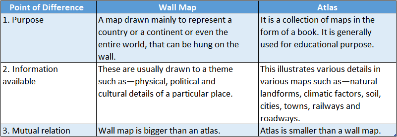
Question 16. Differentiate between a wall map and an atlas.
Answer:

The differences between a wall map and an atlas are as follows—

WBBSE Solutions For Class 6 Geography Chapter 11 Maps Topic B Scale, Direction, Conventional Symbols And Elements Of A Maps Wall map atlats

WBBSE Chapter 11 Maps Topic B Scale, Direction, Conventional Symbols And Elements Of A Maps Very Short Answer Type Questions

Question 1. Name an essential element of a map.
Answer: Scale.

Question 2. A statement scale of a map reads as 1cm to 2.5km. What is the ground distance here?
Answer: 2.5km.

Question 3. In which direction does a compass always point?
Answer: North.

Question 4. Mention the intercardinal points.
Answer: North-east, south-east, north-west, south-west.

Question 5. What is the easiest method to identify direction?
Answer: Observing the sunrise and sunset.

Question 6. Which will be the hand side of a map?
Answer: West direction.

Examples of Conventional Symbols Used in Maps

Question 7. On which side of the Prime Meridian is Kolkata located?
Answer: East.

Question 8. Which colour is used to represent mountains on a globe?
Answer: Brown.

Question 9. Which colour is used to demarcate the ocean bodies on a globe?
Answer: Blue.

Question 10. Which colour is used to demarcate the forest areas on a map?
Answer: Green.

WBBSE Chapter 11 Maps Topic B Scale, Direction, Conventional Symbols And Elements Of A Maps Fill In The Blanks

Question 1. _______________ is the ratio between the map distance and ground distance.
Answer: Scale

Question 2. ‘N’ denotes the_______________ on a map.
Answer: North direction

Question 3. _______________ can be accurately determined with the help of a compass.
Answer: Direction

Question 4. _______________ in the night sky helps us to Determine the north.
Answer: North star

Question 5. When we face the Sun, our right-hand side is the_______________ side.
Answer: Southern

Question 6. _______________ Delhi is located on the side of the map of India.
Answer: Northern

Question 7. Colour is used to_______________ denote a pond or a lake on a map.
Answer: Blue

Question 8. Human settlements are shown in_______________ Colour on a map.
Answer: Red

Question 9. _______________ is key to all symbols used on a map.
Answer: Index

Question 10._______________ provides an idea of the subject explained on a map.
Answer: Title

WBBSE Chapter 11 Maps Topic B Scale, Direction, Conventional Symbols And Elements Of A Maps Write True Or False

Question 1. The ratio between map distance and ground distance is known as cartogram.
Answer: False

Question 2. A cadastral map is a small-scale map.
Answer: False

Question 3. In a cadastral map, 16 inches = 1 mile.
Answer: True

Question 4. Large-scale maps give more information.
Answer: True

Question 5. For the precise determination of the location of a place, both distance and direction are essential.
Answer: True

Question 6. Both the sketch and plan of a place are similar things.
Answer: False

WBBSE Chapter 11 Maps Topic B Scale, Direction, Conventional Symbols And Elements Of A Maps Miscellaneous Type Questions Find The Odd Out

Question 1. Population map: Weather map: Vegetation map: Geological map
Answer: Population map (not a physical map)

Question 2. Map: Cartography: Atlas: Cloud cover
Answer: Benchmark (not related to map making)

Question 3. Wall map: Atlas: Cadastral map: Globe
Answer: Cadastral map (not a small-scale map)

Question 4. Rail lines and roadways are shown on a physical map.
Answer: Thematic map

Question 5. Mountains and hills are shown on a political map.
Answer: Physical map

Question 6. The first atlas was Eratosthenes.
Answer: Ortelius

Question 7. City maps are small-scale maps.
Answer: Large

Question 8. The colour green is used to demarcate waterbodies on a map.
Answer: Blue

Question 9. I am capable of depicting a large area, such as an entire country in an accurately smaller version. Who am I?
Answer: Small-scale map

Question 10. I am a map that illustrates the administrative boundaries of countries, states, cities and towns. Who am I?
Answer: Political map

Question 11. I am the first person to use the term ‘Atlas1 for a collection of maps. Who am I?
Answer: Flemish geographer and cartographer, Gerardus Mercator

Question 12. I represent the record of ownership of land and I usually bear a scale of 16 inches = 1 mile in India. Who am I?
Answer: Cadastral map

Question 13. I am a clay tablet—currently a treasure of the collection at the British Museum. Who am I?
Answer: Imago Mundi (Babylonian world map)

WBBSE Chapter 11 Maps Topic B Scale, Direction, Conventional Symbols And Elements Of A Maps Miscellaneous Formative

Find out the political map of your state from a map book. Write them down correctly—

Question 1. How many districts are there?
Answer: Presently, there are 23 districts in our state.

Question 2. In which district do you live?
Answer: I live in the Hooghly district.

Question 3. What are the names of your surrounding districts?
Answer: The surrounding districts of my district are—

  1. Purba Bardhaman,
  2. Nadia,
  3. North 24 Parganas, Howrah.

Question 4. What is the capital of your state?
Answer: Kolkata is the capital of my state.

WBBSE Solutions For Class 6 Geography chapter 11 Maps miscellaneous type questions Political map of west bengal

Interpretation and Application

This segment will test whether the students have understood topics or whether they are just mugging up.

Question 1. Try to understand and write it down.
Answer:

WBBSE Solutions For Class 6 Geography chapter 11 Maps miscellaneous type questions distance on amap

Question 2. Look at the political map of India. Find out in which direction from Delhi are the following cities located.

  1. Kolkata, South-east,
  2. Mumbai, South-west,
  3. Chennai, South,
  4. Bengaluru South

Question 3. Look carefully at the political map of India. Can you say—

WBBSE Solutions For Class 6 Geography chapter 11 Maps miscellaneous type questions india rivers

1. What is the scale of the map?
Answer: The scale of the map is 1cm = 200km.

2. What are the distances between India’s northernmost and southernmost point and between its easternmost and westernmost point?
Answer: The distance between India’s northernmost and southernmost points is 3214km and the same between easternmost and westernmost points is 2933km.

3. What is the ground distance between Delhi and Kolkata and between Mumbai and Chennai according to the map scale?
Answer: According to the scale mentioned in the map above, the ground distances between Delhi and Kolkata and between Chennai and Bengaluru are 1288km and 1008km respectively.

Question 4. One can learn about India’s main rivers from this map. Would it have been possible to show all these rivers together if they were no maps?

WBBSE Solutions For Class 6 Geography chapter 11 Maps miscellaneous type questions political map in india

Answer: No, it would not have been possible to show all these rivers together if there were no map. There are numerous rivers in our vast country.

Only a river map can represent all these rivers together.

Question 5. The map shows the road from Subho’s house to his school.

WBBSE Solutions For Class 6 Geography chapter 11 Maps miscellaneous type questions Subho's house to his school

1. But how far is the house from school?
Answer: Subho crosses a total distance of (P to Q), (Q to R) and (R to S) to go from his house to school.

These distances on the map measured with a scale are 1cm, 5cm and 2cm respectively. Therefore total map distance is 1cm + 5cm + 2cm = 8cm.

Now, the map scale is 1cm to 100m. Hence, the total ground distance from Subho’s house to school is (8 x 100m) = 800m.

2. Does Subho reach school by walking for 10 minutes or does it take an hour?
Answer: Since the distance between Subho’s house and his school is 800m, it takes him 10 minutes to walk and reach his school.

3. Look there is a scale drawn on the right side of the map. You can get answers to all questions from this scale. How?
Answer: We can measure any distance with the help of a given scale. There is a scale drawn on the right side of the map, which has helped to calculate the distance.

Measure the distance between Subho’s house and the hospital with a centimetre scale. Now you need to know the scale of the map.

Question 6. The scale given below the map shows a distance of 100m as 1cm.
Answer: This means that if the distance between two places is Answer: 1cm on the map, the actual distance between them is (1x100m) = 100m.

So if the distance between ‘A’ and ‘B’ is em, then the actual distance between them is (‘ ‘x 100m) =’ ‘m.
The map distance between ‘A’ and ‘B’ is 1cm, then the actual distance between them is (T x 100m) = ‘lOO’m.

Question 7. We now know the distance between Subho’s house and school. But how can we know which direction the school is from Subho’s house?
Answer: There is an ‘N’ sign on the right side of the map. This denotes the north direction.

Now we can easily recognise that Subho’s school is towards the northeast direction with respect to his house. So Subho’s house is located in the northeast direction of the school and is 800m away.

Questioning and Experimentation

This segment will investigate the student’s understanding of the subject, questioning capacity, ability to explain and apply and urge for experimentation.

Question 1. Observe A Globe If You Have One In Your Home Or School.

1. Around what does the globe rotate?
Answer: The globe rotates on an imaginary axis.

2. Can you identify the continents and oceans on a globe? Find out where your country is.
Answer: Yes, I can identify the continents and oceans on the globe. Our country India is in the northeastern hemisphere.

3. What are the lines drawn vertically and horizontally in circles around the globe called?
Answer: The lines drawn vertically or in the north-south direction are the meridians of longitude and the lines drawn horizontally or in the east-west direction are the parallels of latitude.

Question 2. Stand on the roof of your house or in the courtyard when the sun rises in the morning and notice the direction in which the houses near your place are located.
Answer: The houses near my house are located in the following directions—

Abdul s house is in the northwest, Rimpa’s house is towards the west, our local club is towards the east, the Kali temple is towards the south and a primary school is located towards the southeast.

Empathy and Cooperation:

This segment will determine the ability of students to work as a team.

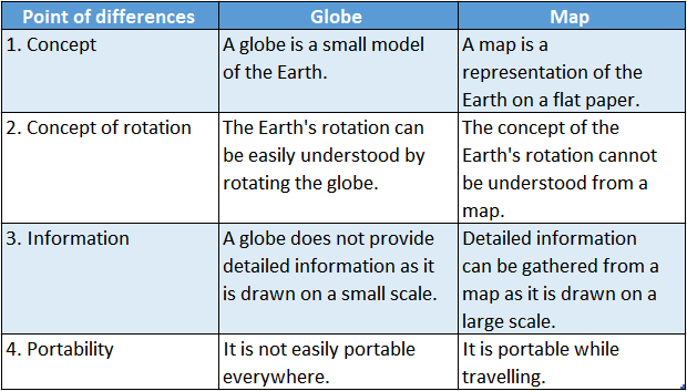
Question 1. Make two groups among your friends. One group is ‘globe’, and the other is ‘map’. Now discuss what are the advantages and disadvantages of a globe and a map.
Answer:

Globe is a small model of the Earth, whereas a map is a representation of the Earth on flat paper.

WBBSE Solutions For Class 6 Geography chapter 11 Maps miscellaneous type questions Advantages and disadavantages

Aesthetics and Creativity

This segment will check the aesthetic sense and creativity of the students.

Question 1. Draw a layout of your classroom.
Answer:

The layout of my classroom can be illustrated as follows—

WBBSE Solutions For Class 6 Geography chapter 11 Maps miscellaneous type questions The layout of my classroom

Question 2. There is a beautiful park in front of Rahim and Arka’s homes. Both have drawn pictures of the park.

1. Notice the pictures and find out the similarities and dissimilarities.

WBBSE Solutions For Class 6 Geography chapter 11 Maps miscellaneous type questions rahim's drawing Arka's drawing

Answer:

Similarity:

The main similarity between these two pictures is that location of the elements inside the park is approximately the same in both pictures.

Dissimilarities: The dissimilarities between the drawings are:

WBBSE Solutions For Class 6 Geography chapter 11 Maps miscellaneous type questions rahims and arkas drawing

Question 2. Find which picture shows us better where this place actually is.
Answer:

Features of the park are more well-sketched in Rahim’s drawing than that Arka’s.

WBBSE Solutions For Class 6 Geography chapter 11 Maps miscellaneous type questions Surroundings of my shcool

Question 3. Like them try to draw a picture of your home or school and its surroundings.
Answer:

In the sketch, you have made the path from your house to your school. Use signs, symbols and colours such as a playground, park (green colour); ponds (blue colour), and houses (red).

Besides these, for temples, rail stations, and post offices you can use specific signs from the table. Finally, to denote which area is represented by what colour, make an index.

I am Ayushman Jana. I live in the district of East Medinipur. I have drawn a sketch map to depict various physical and cultural features on my way to school, using conventional colours, signs, and symbols and these conventional signs and symbols are shown in an index beside.

WBBSE Solutions For Class 6 Geography chapter 11 Maps miscellaneous type questions a skecth of the path from my house to school

WBBSE Chapter 11 Maps Topic B Scale, Direction, Conventional Symbols And Elements Of A Maps Match The Columns

Question 1.

WBBSE Solutions For Class 6 Geography Chapter 11 Maps Topic B Scale, Direction, Conventional Symbols And Elements Of A Maps match the following
Answer: 1-C,2-A,3-E,4-B,5-D

WBBSE Solutions For Class 6 Geography Chapter 11 Maps Topic A Accurate Representation Of The Earth

WBBSE Chapter 11 Maps Topic A Accurate Representation Of The Earth Long Answer Type Questions

Question 1. Why are a globe and a map essential components for learning geography?
Answer:

A globe and a map essential components for learning geography:

The reasons why a globe is an essential component for learning geography are as follows—

Occurrence of day and night:

The occurrence of day and night on Earth can be explained better with the help of a globe.

Concept of the Earth’s axis:

The Earth’s axis is tilted at an angle of 661/2° to the orbital plane of the Earth. This concept can be easily understood with the help of a globe.

Short Questions on Accurate Maps

The reasons why maps are an essential component of learning geography are as follows—

Concept of a region:

The role of maps is most important for gaining a clear idea about a region.

Knowledge about geographical aspects:

We depend on maps in order to collect information like topography, rivers, climate, transportation, population, agriculture, industry, trade, etc of a region.

Determination of direction:

Maps are required to get an idea about the cardinal directions.

Question 2. Discuss the different types of maps.
Answer:

Different types of maps:

Maps can be primarily divided into three categories.

They are as follows—

Physical maps:

Maps depicting several physical features like mountains, plains, plateaus, deserts, rivers, and natural vegetation are called physical maps.

Political maps:

Maps showing countries and states with their boundaries are called political maps.

Thematic maps:

Maps that show specific information on specific themes such as population, roadways, railways, minerals, etc. are called thematic maps.

Common Questions About Map Accuracy

Question 3. How is the location of any place on the globe determined?
Answer:

The location of any place on the globe determined:

The location of any place on the globe is determined by the help of parallels of latitude and meridians of longitudes.

The point of intersection between parallels and meridians is the exact location of any place.

The imaginary, circular lines running across the surface of the globe in an east-west direction are called lines of latitude. They are parallel to the Equator and to each other.

The semicircular, imaginary lines running from the North Pole to the South Pole and intersecting the Equator at right angles are called lines of longitude.

They are equal in length but hot parallel to each other. The intersection of these imaginary lines of latitude and longitude, known as the geographic grid, allows us to give a mathematical value to the location of any place on the globe.

WBBSE Solutions For Class 6 Geography Chapter 11 Maps Topic A Accurate Representation Of The Earth

Question 4. Write a brief note on cartography.
Answer:

Cartography:

The science and art of making maps is known as cartography. It involves the representation of political, cultural, economic and other attributes in a specific geographic area.

The technology used for cartography has been continuously changing. The first maps were hand-painted and lacked accuracy.

The advent of the compass and eventually computers have made maps more accurate and useful.

Question 5. What is the usefulness of a map?
Answer:

Usefulness of a map:

A map is an essential tool that helps us to study geography.

It is used to determine the locations of rivers, mountains and landforms in various cities, countries or continents. Maps influence all our lives.

For example, the location and extension of land boundaries, roadways, rivers, ponds, settlements, and religious establishments can be determined from a cadastral map.

The distance of a particular settlement from the roadways or railways, the nature of a settlement or a forest can also be determined by using a map.

Question 6. Write The Difference Between A Globe And A Map.
Answer:

The difference Between a globe and a map are as follows-

WBBSE Solutions For Class 6 Geography chapter 11 Maps Topic A Accurate Representation Of The Earth Globe and maps

Practice Questions on Globe vs. Map Accuracy

Question 7. Which is considered to be the most recent era of map making?
Answer:

The most recent era of map making:

From cave paintings to ancient maps of Babylon, Greece and Asia, till the 21 century, people have developed and used maps for various purposes.

In the 15 century, maps were drawn on wooden or copper planks. Maps became increasingly accurate and factual during the 17,18 and 19 centuries with the application of scientific methods.

This is known as the modern era of maps. The world was poorly known until the widespread use of aerial photography following World War-1 Modern cartography is based on a combination of ground observations and remote sensing.

Question 8. Write a short note on the cadastral map.
Answer:

Cadastral map:

Cadastral maps show individual landed property or land registration, that is, the record of ownership of land.

One key feature of a cadastral map is that it carries detailed information about a particular location.

It is an official map that is generally not available for sale. A usual cadastral map in India bears a scale of 16 inches = 1 mile.

WBBSE Chapter 11 Maps Topic A Accurate Representation Of The Earth Short Answer Type Questions

Question 1. What Is meant by a map?
Answer:

Map:

A map is a diagrammatic representation of the entire Earth’s surface or a section of it, showing the geographical distribution of natural features such as relief, rivers or artificial features such as roads, cities, etc. drawn to a particular scale.

The word ‘map’ is derived from the Latin word ‘mapa’ meaning napkin or cloth. Thus, the map is the two-dimensional representation of our three-dimensional Earth.

Question 2. What is meant by a physical map?
Answer:

Physical map:

A physical map is an illustration of the geographic features of an area depicting the mountains, rivers, forests, etc. Different colours are used for different features—blue for water, green for forest, brown for relief and so on. Examples of physical maps are—

  1. Geological map,
  2. Weather map,
  3. Natural vegetation map, etc.

Question 3. What are the different types of physical maps?
Answer:

There are different types of physical maps. They are—

  1. The physiographic map,
  2. Drainage map,
  3. Relief map,
  4. Weather map,
  5. Natural vegetation map,
  6. Soil map and such others.

Important Definitions Related to Map Accuracy

Question 4. What is meant by a political map?
Answer:

Political map:

Political maps illustrate the administrative boundaries of countries, states, cities, towns and villages.

They usually do not include physical features, apart from important waterbodies that help us to determine locations.

Different colours are used to denote different administrative areas. Locations of cities both large and small are depicted depending on the scale of the map. A capital city is generally marked within a circle.

Question 5. What is a thematic map?
Answer:

Thematic map:

A map is especially drawn to show a particular theme related to a specific geographic area known as a thematic map.

These maps usually portray the physical, social, economic, and sociological details of a city, state, region, country or continent.

Examples of thematic maps are maps showing roadways, railways, distribution of minerals, etc.

Question 6. How did the word exist?
Answer:

Word MAP exist:

The word ‘map’ is derived from the Latin word ‘mapa’ meaning napkin or cloth. The reason is that in ancient times, maps were drawn on cloth, leather and similar other articles.

Conceptual Questions on Distortion in Maps

WBBSE Chapter 11 Maps Topic A Accurate Representation Of The Earth Very Short Answer Type Questions

Question 1. What kind of a map is an environmental map?
Answer: Thematic map.

Question 2. Where was the oldest known map discovered?
Answer: Babylon.

Question 3. Which Greek God’s name was used to name the first book of maps?
Answer: Atlas.

Question 4. What is the art of making maps called?
Answer: Cartography.

Question 5. What does the globe rotate on?
Answer: Axis.

Question 6. Name the globe’s axial movement.
Answer: Rotation.

Question 7. Name the lines running north-south on a globe.
Answer: Meridians of Longitude.

Question 8. Name the lines running east-west on a globe.
Answer: Parallels of Latitude.

WBBSE Chapter 11 Maps Topic A Accurate Representation Of The Earth Fill In the Blanks

Question 1. The features of the Earth’s surface, when depicted on paper drawn to a particular scale, are known as__________________
Answer: Map

Question 2. Mineral resource distribution map is a type of__________________ map.
Answer: Thematic

Question 3. Collection of maps in a form of a book is known as__________________
Answer: Atlas

Question 4. __________________is the art of map-making.
Answer: Cartography

Question 5. Nowadays maps are generated from satellite imageries through__________________
Answer: Computers

Question 6. inch mile= __________________is the scale of a cadastral map.
Answer: 1

Examples of Accurate World Maps

WBBSE Chapter 11 Maps Topic A Accurate Representation Of The Earth Write True Or False

Question 1. A small model of the Earth is known as a globe.
Answer: True

Question 2. Commercial maps depict mountains and hills.
Answer: False

Question 3. A book of maps is known as an Atlas.
Answer: True

Question 4. The thematic map always shows the density of any geographical data.
Answer: False

Question 5. The true depiction of the Earth can be found on a globe.
Answer: False

Question 6. Maps can be produced from satellite images with the help of computers.
Answer: True

WBBSE Chapter 11 Maps Topic A Accurate Representation Of The Earth Match The Columns

Question 1.

WBBSE Solutions For Class 6 Geography chapter 11 Maps Topic A Accurate Representation Of The Earth match the following
Answer: 1-D,2-C,3-A,4-B

WBBSE Solutions For Class 6 Geography Map Pointing

Question 1.

Answer: 

  1. Tropical Humid Climatic region
  2.  Dry Climatic region
  3. Semi-Arid Climatic region
  4. Tropical Savana
  5. Climatic region
  6. Mountain
  7. Climatic region
  8. Wet Tropical Climatic region

WBBSE Solutions For Class 6 Geography Map pointing 1

Question 2.

Answer: 

  1. Kanchenjunga
  2. Coromandel Coast
  3. River Ganga
  4. Wet Tropical Climatic region
  5. A region with mountain soil
  6. Tropic of Cancer
  7. Gulf of Khambat
  8. A Bengali language-speaking region
  9. Northern Circars
  10. Indira Point
  11. River Luni
  12. Aravalli Range
  13. Arabian Sea
  14. Nepal
  15. Vindhya Range

WBBSE Solutions For Class 6 Geography Map pointing .2

WBBSE Class 6 Map Pointing Notes

WBBSE Solutions For Class 6 Geography Map Pointing

Question 3.

Answer: 

  1. Mount Everest
  2. Konkan Coast
  3. River Kaveri
  4. Northern Plains
  5. Mangrove vegetation
  6. Satpura Range
  7. Largest mangrove forest
  8. Malabar Coast
  9. Sri Lanka
  10. Delhi (The capital of India)
  11. Gulf of Mannar
  12. Palk Strait
  13. Chilka Lake
  14. Kathiawar Peninsula
  15. Garo Hills

WBBSE Solutions For Class 6 Geography Map pointing 3

Question 4. 

Answer: 

  1. Pirpanjal Range
  2. Siwalik Range
  3. Karakoram Range
  4. Western Ghats
  5. Godwin Austin
  6. Rann of Kachchh
  7. Thar Desert
  8. Meghalaya Plateau
  9. Andaman and Nicobar Islands
  10. East Coast of India
  11. Black Soil region
  12. Tea Producing region of India
  13. Jute producing region
  14. Paddy producing region
  15. Peninsular Plateau region of the Deccan Plateau
  16. Eastern Ghats

WBBSE Solutions For Class 6 Geography Map pointing 4

Short Questions on Map Pointing Techniques

Question 5. 

Answer: 

  1. River Krishna
  2. River Narmada
  3. River Godavari
  4. River Mahanadi
  5. River Brahmaputra
  6. Mumbai
  7. Kolkata
  8. Bengaluru
  9. Mawsynram
  10. Srinagar
  11. Bhubaneswar
  12. Desert soil region
  13. Kaziranga National Park
  14. A National Park
  15. Black soil region

WBBSE Solutions For Class 6 Geography Map pointing 5

WBBSE Solutions For Class 6 Geography Chapter 10 Our Country India Topic G Agriculture Of India

WBBSE Chapter 10 Our Country India Topic G Agriculture Of India Long Answer Type Questions

Question 1. What is Green Revolution? Or, What are the changes and impacts t associated with Green Revolution?
Answer:

Green Revolution:

The Green Revolution is a series of research and technological developments that were applied to agriculture and which then resulted in a significant increase in agricultural production. It began in India in the 1960s.

The type of changes and impacts associated with the Green Revolution are as follows—

1. Biochemical innovations: This involved a selection of hybrid seeds, the use of fertilisers, herbicides and pesticides.

Consequently, there was a drastic increase in the yield of crops. Pests and weeds were also under control.

2. Mechanical innovations: Irrigation facilities using electric and petrol pumps were introduced under the Green Revolution. Improved transportation was also brought into use.

As a consequence, access to water supply surpassed the sole dependence on rainfall, an extension of arable land was noticed, less labour was needed and there was increased access to markets.

3. Social innovations: With the Green Revolution, there was a huge enhancement in the distributive system, loan systems and also in land reforms. Farms were consolidated. Better quality seeds and other inputs were made available to farmers.

Question 2. What is the physical environment favourable for paddy cultivation Name four states which produce paddy
Answer:

Physical environment favourable for paddy cultivation:

Paddy is the main crop of the tropical climatic conditions suitable for cultivation of paddy in

India are as follows—

1. Climate: The two major elements of climate that affect paddy cultivation are temperature and rainfall.

Temperature: The average annual temperature required for growing paddy ranges from 22°C to 32°C. But paddy can also grow at temperatures ranging from 16°C-27°C.

Rainfall: Paddy is a thirsty crop. Abundant water is required for paddy to grow, but, at the same time, during the harvest, there should be bright sunshine. The average annual rainfall required for growing paddy ranges between 150 and cm-300 cm.

2. Soil: The best soil for growing paddy is loamy alluvial soil. The slope of the land should be such that during the growing season, there should be standing water on the field.

3. Irrigation: Paddy requires an ample amount of rainfall. In the absence of rainfall proper irrigation facilities should be maintained.

4. Labour: Paddy is a labour-intensive crop. Planting seeds, harvesting, and fertilising all require manual labour.

Cultivating states: West Bengal, Assam, Tamil Nadu and Uttar Pradesh are four of the many paddy-growing states in India. West Bengal tops the list of growing paddy in India.

WBBSE Class 6 Agriculture of India Notes

Question 3. What are the favourable climatic conditions for growing wheat in India? Name four states of India that produce wheat.
Answer:

The favourable climatic conditions for the cultivation of wheat in India are as follows—

Climate: The two major elements of climate that affect wheat cultivation are temperature, rainfall and frost-free days.

Temperature: The average annual temperature required for growing wheat ranges from 15°C to 20°C. Wheat is generally cultivated during winter in India.

Rainfall: The average rainfall required for growing wheat ranges from 50 cm to 100 cm.

Frost-free days: A minimum of 110 frost-free days are required for the successful cultivation of wheat.

Soil: The best soil for growing wheat is lime-rich loamy soil.

Landforms: Flat or rolling plain land with an improved drainage system is required for the cultivation of wheat.

Cultivating states: Uttar Pradesh, Haryana, Bihar and Punjab are the leading states in producing wheat in India.

WBBSE Solutions For Class 6 Geography Chapter 10 Our Country India Topic G Agriculture Of India

Question 4. Discuss the favourable climatic conditions for cultivating millets (jowar, bajra and ragi) in India and name the millet-growing regions.
Answer:

The favourable climatic conditions for the cultivation of millets and the states growing millets in India are—

1. Jowar:

Climate: The average annual temperature required for growing jowar ranges from 27°C- 32°C and the average annual rainfall required for growing jowar ranges from 30 cm-100 cm.

Soil: Sandy soil and sandy-loamy soil.

Cultivating States: Andhra Pradesh, Maharashtra, Karnataka, Madhya Pradesh, Rajasthan and others.

2. Bajra:

Climate: The average annual temperature required for growing bajra ranges from 25°C-28°C and the average annual rainfall required for growing bajra ranges from 40 cm-50 cm.

Soil: Sandy soil and sandy-loamy soil.

Cultivating States: Rajasthan, Uttar Pradesh, Gujarat, Haryana, Maharashtra and others.

3. Ragi:

Climate: The average annual temperature required for growing ragi ranges from 27°C-32°C and the average annual rainfall required for growing ragi ranges from 35 cm-60 cm.

Soil: Sandy soil and sandy-loamy soil.

Cultivating States: Karnataka, Tamil Nadu, Andhra Pradesh, Maharashtra, Bihar and others.

Short Questions on Agriculture in India

Question 5. Discuss the favourable climatic conditions and the regions for lentil cultivation.
Answer:

The climatic conditions suitable for the cultivation of lentils and the states growing lentils in India are as follows—

1. Climate:

Temperature: The average annual temperature required for growing lentils ranges from 20°C-30°C.

Rainfall: The annual average rainfall required for growing lentils ranges from 50 cm to 75 cm.

Soil: The best soils for growing lentils are loamy soil and black soil.

Cultivating states: Most states of India cultivate lentils, but Uttar Pradesh, Madhya Pradesh, Rajasthan, Gujarat, Maharashtra, Andhra Pradesh, Karnataka and West Bengal are at the top of the list.

Question 6. Discuss the climatic conditions suitable for cultivating sugarcane in India and name the sugarcane-growing regions.
Answer:

The climatic conditions suitable for the cultivation of sugarcane and the states growing sugarcane in India are as follows—

Climate:

Temperature: The average annual temperature required for growing sugarcane ranges from 25°C to 30°C.

Rainfall: The average annual rainfall required for growing sugarcane ranges from 100 cm to 150 cm.

Soil: The best soil for growing sugarcane is loamy soil rich in nitrogen and potash with an improved drainage system.

Cultivating states: Uttar Pradesh, Bihar, Punjab, Rajasthan, Maharashtra, Karnataka and Andhra Pradesh top the list.

Common Questions About Farming Practices in India

Question 7. Discuss the Favourable climate conditions for cultivating jute in India and name the jute-growing regions.
Answer:

The favourable climatic conditions for the cultivation of jute and the jute-growing states in India are as follows—

Climate:

Temperature: The average annual temperature required for growing jute ranges from 28°C to 36°C.

Rainfall: The average annual rainfall required for growing jute ranges from 150 cm to 200 cm.

Soil: The best soils for growing jute are clayey alluvial soil and loamy soil.

Cultivating states: West Bengal, Bihar and Odisha top the list.

Question 8. Discuss the favourable climatic  Conditions for cultivating, cotton in India and name the cotton-growing
Answer:

The favourable climatic conditions for the cultivation of cotton and the states growing cotton in India are as follows—

Climate:

Temperature: The average annual temperature required for growing cotton ranges from 20°C to 35°C.

Rainfall: The average annual rainfall required for growing cotton ranges from 50 cm to 100 cm.

Soil: The best soil for growing cotton is well-drained phosphate and lime-rich black soil.

Cultivating states: Maharashtra, Gujarat, Madhya Pradesh, Tamil Nadu, Punjab and Haryana are the major cotton-growing states.

Question 9. Discuss conditions for cultivating tea in India
Answer:

The favourable climatic conditions for the cultivation of tea and the states growing tea in India are as follows—

Climate:

Temperature: The average annual temperature required for growing tea ranges from 20°C to 30°C.

Rainfall: The average annual rainfall required for growing tea ranges from 150 cm to 200 cm.

WBBSE Solutions For Class 6 Geography Chapter 10 Our Country India Topic G Agriculture Of India tea cultivation

Conceptual Questions on Agricultural Challenges in India

Soil: Humus-rich loamy soil with high water holding capacity on a slopy land is the best soil for growing tea.

Cultivating states: Assam, West Bengal, Karnataka, Kerala and Tamil Nadu grow the most amount of tea that India produces.

Question 10. Discuss the favourable climatic conditions for cultivating coffee in India and name the coffee-growing regions.
Answer:

The favourable climatic conditions for the cultivation of coffee and the states growing coffee in India are as follows—

Climate:

Temperature: The average annual temperature required for growing coffee ranges from 18°C to 28°C.

Rainfall: The average annual rainfall I required for growing coffee ranges from 150 cm to 200 cm.

Soil: The soil required for growing coffee should be rich in iron, potash, nitrogen and humus. Sloppy land with an improved drainage system also helps in coffee cultivation.

Cultivating states: Karnataka, Kerala and Tamil Nadu contribute the most to the production of coffee in India.

Question 11. What are the main features of Indian agriculture?
Answer:

The main characteristics of Indian agriculture are as follows—

Great dependence on monsoons and low to moderate availability of irrigation facilities throughout the country.

The fluctuations and inequality in crop production are dependent on climatic factors, soils and variations in physiography.

More dependence on food crops along with reliance on age-old agricultural practices.

Question 12. Write a short note on shifting cultivation.
Answer:

Shifting cultivation:

Shifting cultivation is a type of subsistence farming. Almost 85% of the cultivation that takes place in the northeastern states of India is of this type.

In shifting cultivation, the existing vegetation on land is cut and burnt down and then the stretch of land is cultivated for a few years unless the yield of the crop reduces, the fertility of the soil is exhausted and the field is affected by pests and weeds.

As the crop yield reduces, the land is deserted to allow it to regain its fertility.

The length of time for which the land is cultivated is always shorter than the length of time for which the land remains fallow.

Shifting cultivation is also known as Jhum cultivation and the people practising it are known as Jhumia.

Real-Life Scenarios Involving Agricultural Practices

Question 13. What are the harmful effects caused by jhum cultivation on the environment?
Answer:

The harmful effects caused by jhum cultivation on the environment are hereafter—

  1. Clearing of forested lands leads to increased pollution.
  2. Air pollution is caused by the burning down of forests.
  3. An increase in soil erosion due to the absence of trees leads to sedimentation of the nearby rivers.
  4. The ecological balance of the place is disturbed.
  5. Various plant and animal species die because of the burning of forests. Many species even face extinction.

Question 14. What steps are taken to enhance the fertility of agricultural land?
Answer:

The steps taken to enhance the fertility of agricultural land are as follows—

  1. Regular application of natural (cow dung) and artificial (urea and potash) fertilisers on agricultural land.
  2. Improved agricultural practices such as multiple cropping should be encouraged.
  3. Reduction in the use of excessive amounts of pesticides on the crops.
  4. Reduction in the dependence on rainfall and more usage of irrigation facilities.
  5. Use of HYV seeds of modern and mechanised agricultural implements.

Question 15. Which places in India are popular for paddy cultivation?
Answer:

Places in India are popular for paddy cultivation:

India has the largest paddy output in the world. West Bengal holds first place in paddy production.

Apart from this, paddy is cultivated along the entire eastern and western coastal plains, the Himalayan foothill regions and also the Gangetic Plain regions.

Bihar, Assam, Uttar Pradesh, Haryana, Odisha, Andhra Pradesh etc are the other important rice-growing states of India.

Question 16. Which places in India are popular for wheat cultivation?
Answer:

The northern regions in India have always been prominent in the cultivation of wheat. They can be subdivided into the following-

Northern Hill Zone: Hilly areas of Jammu and Kashmir, Himachal Pradesh and Uttarakhand, Sikkim.

North-Western Plain Zone: Parts of Punjab, Haryana, western Uttar Pradesh, Rajasthan, Delhi, Uttarakhand, and Chandigarh.

North-Eastern Plain Zone: Parts of eastern Uttar Pradesh, Bihar, Jharkhand, West Bengal, Assam, Odisha and the north-eastern states.

Central Zone: Parts of Madhya Pradesh, Gujarat, Chattisgarh, Rajasthan

Peninsular Zone: Parts of Maharashtra, Tamil Nadu, Karnataka and Andhra Pradesh.

Southern Hill Zone: Parts of Tamil Nadu.

Examples of Major Agricultural Products in India

Question 17. Cotton, jute and tea are cash crops/ —Why?
Answer:

Cotton, jute and tea are cash crops:

Beautiful and fancy clothes made out of cotton and jute are mostly used for industrial purposes. Tea earns a huge amount of foreign currency.

Jute, cotton and tea along with the end-products made from them have great market value, not only in native markets but also abroad.

All these are important products for export and import. Thus cotton, jute and tea are known to be cash crops.

WBBSE Chapter 10 Our Country India Topic G Agriculture Of India Short Answer Type Questions

Question 1. Why is India known as an agro-based country?
Answer:

India known as an agro-based country:

A large section of the Indian population is directly or indirectly dependent on agriculture. A prominent percentage of the national income is based on agriculture.

All developmental planning in India is done on the basis of the amount of productivity and the nature of agriculture.

In India, 54% of the land area is used for agriculture. Thus India is knowns as an agro-based country.

Question 2. Why Is irrigation necessary for agriculture?
Answer:

Irrigation necessary for agriculture:

The use of water is indispensable for agriculture. Before irrigation facilities were available, agriculture was absolutely dependent on rainfall.

Rainfall, being a natural phenomenon, is sometimes irregular. So canal, well and tank irrigation were brought into use.

The crops receive a timely and adequate amount of water through irrigation. For instance, in winter, wheat needs a lot of water and this is supplied through irrigation.

Question 3. What is meant by food crop?
Answer:

Food crop:

Crops that are cultivated mainly for human consumption are known as food crops. The common food crops in India are rice, wheat, millet, maize, etc.

Question 4. What is meant by cash crop?
Answer:

Cash crop:

Crops that are grown for their commercial value rather than for consumption are known as cash crops. The common cash crops in India are jute, sugarcane, cotton and oilseeds.

Question 5. What is meant by rabi crop?
Answer:

Rabi crop:

The word ‘rabi’ comes from the Arabic word for spring. Rabi crops also known as winter crops – are sown in winter and harvested in spring. The common rabi crops are wheat, gram and mustard.

Important Definitions Related to Indian Agriculture

Question 6. Mention the sowing and harvesting seasons of rabi crops.
Answer:

The sowing and harvesting seasons of rabi crops

Rabi crops are also known as winter crops. They are sown in the months of October- November and harvested in the months of March-April.

Question 7. What is meant by the Kharif crop?
Answer:

Kharif crop:

The word ‘kharif’ comes from the Arabic word for autumn. Kharif crops also known as monsoon crops are sown with the advent of monsoon in south-eastern Asia.

They are harvested in autumn that is, around October. The common kharif crops are rice, millet and maize.

Question 8. Mention the sowing and harvesting seasons for Kharif crops.
Answer:

The sowing and harvesting seasons for Kharif crops:

Kharif crops are also known as monsoon crops. They are sown in the months of June-July and harvested in the months of September- October.

Question 9. What is meant by zaid crop?
Answer:

zaid crop:

The crops that are sown in February/ March and harvested in May/June are known as zaid crops.

These crops are grown in the time period between Kharif and rabbi crops. For example, vegetables of the cucurbit family (pointed gourd, bottle gourd, cucumber, etc.)

Question 10. Name the types of crops grown in India. Give examples.
Answer:

The types of crops grown in India are—

Food crops: paddy, wheat, millet

Vegetable crops: potato, brinjal, narwhal

Beverage crops: tea, coffee

Fibrous crops: cotton, jute

Other crops: lentils, oil seeds, rubber.

Question 11. What is meant by terrace cultivation? Or, What is meant by step cultivation?
Answer:

Terrace cultivation:

The method of cultivation that involves growing crops on a graduated terrace or step-cut surfaces, built along a hill slope is known as terrace cultivation or step cultivation.

This type of cultivation reduces soil erosion and surface run-off but is labor-intensive. It is an environment-friendly way of cultivation.

WBBSE Solutions For Class 6 Geography Chapter 10 Our Country India Topic G Agriculture Of India terrace cultivation

Practice Questions on Rabi and Kharif Crops

Question 12. Which soil is best for cotton cultivation?
Answer:

Cotton grows best in silty and clayey soils- both of which contain sand.

In India, the highest concentration of cotton cultivation is seen in the Deccan Plateau region which is overlaid by black soil, popularly known as black cotton soil.

This soil is black in colour due to the presence of compounds of iron and aluminium and organic matter content.

Question 13. What is meant by subsistence farming?
Answer:

Subsistence farming:

Subsistence farming, also known as self-sufficiency farming, is mainly done to maintain the needs of the farmer and his family. Very little or no surplus exists for trading purposes.

This type of farming is done with barely any modern equipment and it includes both crop yielding and raising of animals.

The yield per unit of land is high and is mainly practised in countries with high population density.

Question 14. What is meant by extensive farming?
Answer:

Extensive farming:

Extensive farming is carried out in places with sparse populations, especially in countries with a lower density of population.

This type of farming involves less capital and labour as compared to the area being farmed but involves extensive use of technology.

Both crop cultivation and animal rearing can be done under extensive farming and the yield per unit of land is low.

Question 15. Why is jute called the ‘golden fibre’?
Answer:

Golden fibre:

Jute is a fibre crop. This is the only natural fibre that bears an original golden colour.

Thus un-dyed jute can be used for making several fancy products that are sold in the market at high prices.

So, the natural golden colour and high market price earned jute the name of the ‘golden fibre’.

WBBSE Chapter 10 Our Country India Topic G Agriculture Of India Very Short Answer Type Questions

Question 1. What are the crops that are sown in winter and harvested in spring known as?
Answer: Rabi crops.

Question 2. Which crop is cultivated with the onset of monsoon?
Answer: Kharif crop.

Question 3. Which region in India is famous for Jhum Cultivation?
Answer: The hilly regions of north-eastern India.

Question 4. Name the season in which orange grows the best.
Answer: Winter.

Question 5. Name the coarsest millet.
Answer: Ragi.

Question 6. What type of crop is millet?
Answer: Cereal crop.

Question 7. Which state ranks first in the production of sugarcane in India?
Answer: Uttar Pradesh.

Question 8. Which crop grows best on hill slopes?
Answer: Tea.

Question 9. Which state ranks first in the production of paddy in India?
Answer: West Bengal.

Question 10. Name the wind that influences the agriculture of our country the most.
Answer: Monsoon winds.

Question 11. Which season is mostly associated with the cultivation of wheat?
Answer: Winter.

Question 12. Which soil is best for cotton cultivation?
Answer: Phosphate and lime-rich Black soil.

Question 13. Which soil is best for paddy cultivation?
Answer: Loamy alluvial soil.

Question 14. Which soil is best for wheat cultivation?
Answer: Lime-rich loamy soil.

Question 15. Which climate is best for paddy cultivation?
Answer: Monsoon.

Question 16. Name the alternative beverage crop for tea.
Answer: Coffee.

Question 17. Name a winter vegetable.
Answer: Cauliflower.

WBBSE Chapter 10 Our Country India Topic G Agriculture Of India Fill In The Blanks

Question 1. Sugarcane is a_____________ crop.
Answer: Cash

Question 2. Apart from tea,_____________ is also an example of a beverage crop.
Answer: Coffee

Question 3. _____________involves clearing the existing forest cover and burning it down before cropping.
Answer: Jhum Cultivation

Question 4. _____________ are used to control pests from damaging agricultural crops.
Answer: Pesticides

Question 5. _____________ are used to enhance the productivity of agricultural lands.
Answer: Fertilisers

Question 6. _____________ is required during the dry seasons to enhance crop production.
Answer: Irrigation

Question 7. _____________is known as the ‘Staple food of India’
Answer: Rice

Question 8. The success of the ‘Green Revolution in India has escalated the production of _____________
Answer: Wheat

Question 9. The southern state of_____________ is the highest producer of coffee in India
Answer: Karnataka

Question 10. The Central Institute for Cotton Research is located in _____________
Answer: Nagpur

Question 11. _____________ Central Research Institute for Jute and Allied Fibres is situated in Barrackpore, West Bengal is a premier institute to study
Answer: Jute

Question 12. _____________ soil is best for the cultivation of paddy.
Answer: Alluvial

Question 13. _____________ is the ‘Rice bowl of West Bengal’.
Answer: Burdwan

Question 14. _____________ and are the kinds of coffee that are cultivated more in India
Answer: Arabica, Robusta.

WBBSE Chapter 10 Our Country India Topic G Agriculture Of India Write True Or False

Question 1. Jowar is known as ‘kolam’ in Tamil.
Answer: True

Question 2. The Green Revolution took place during the first 5-year plan.
Answer: False

Question 3. India is the highest producer of jute in the world.
Answer: True

Question 4. Regur soil is the best for the cultivation of jute in India.
Answer: False

Question 5. Gujarat ranks first in the production of cotton in India.
Answer: True

Question 6. Tamil Nadu grows the highest density of sugarcane per hectare in India.
Answer: True

Question 7. Central Research Institute for Jute and Allied Fibres is in Bangalore, Karnataka.
Answer: False

Question 8. Coconut belongs to the palm family.
Answer: True

Question 9. Andhra Pradesh ranks first in the production of groundnut in India.
Answer: False

Question 10. Karnataka accounts for the highest contribution to coffee production in India.
Answer: True

WBBSE Chapter 10 Our Country India Topic G Agriculture Of India Match The Columns

Question 1.

WBBSE Solutions For Class 6 Geography Chapter 10 Our Country India Topic G Agriculture Of India match the columns
Answer: 1-E, 2-G,3-B,4-F, 5-D,6-C,7-A