WBBSE Solutions For Class 7 Geography Chapter 9 Continent Of Asia Topic A Revolution Of The Earth

WBBSE Chapter 9 Continent Of Asia Topic A Revolution Of The Earth Long Question And Answers

Question 1. Why is Asia called ‘The land of extreme diversities’? or, State the geographical importance of Asia.
Answer:

Asia-‘The land of extreme diversities’:

Asia is called ‘The land of extreme diversities’ because of the following reasons-

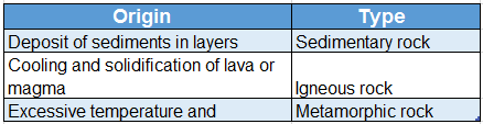
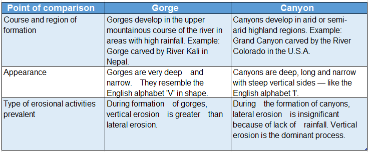
1. Geological diversity:

The continent of Asia bears evidence of different geological ages. It contains parts of the two oldest landmasses-Angaraland and Gondwana- land as well as the newly formed Himalayan Ranges and most recently formed Sunderbans.

2. Geographical diversity:

Mt. Everest, the highest peak of the world as well as the Dead Sea, the lowest part on the landmass of the Earth are both located in Asia.

Read And Learn Also WBBSE Solutions For Class 7 Geography

3. Climatic diversity:

Jacobabad (summer temperature 52°C) is the hottest place in Asia. On the other hand, Oymyakon (temperature -71.2°C), the coldest place in the world lies here. Again, Mawsynram (average annual rainfall 1392 cm), the wettest place in the world lies in Asia.

4. Diversity in drainage:

There are big snow-fed rivers as well as small rain-fed rivers in this continent. Caspian Sea, the largest lake. in the world and Baikal, the deepest lake are both located in Asia.

5. Diversity in vegetation:

This continent has the extensive Taiga region in the north as well as xerophytic vegetation in the desert region.

WBBSE Solutions For Class 7 Geography Chapter 9 Continent Of Asia Topic A Revolution Of The Earth

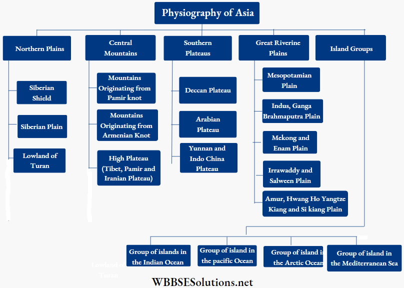
Question 2. Describe the physiography of Asia.
Answer:

Physiography of Asia:

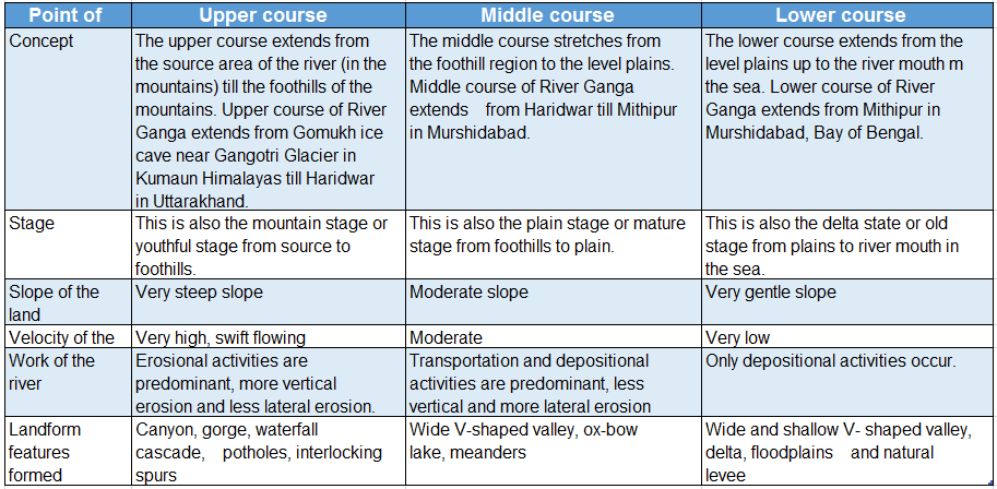
Asia has diverse physical features. Asia can be divided into the following six divisions on the basis of its physical features-

The Northern Plains:

The Northern Plains extend from the Caspian Sea in the west to Bering Strait in the east and from the Central Mountains in the south to the Arctic Ocean in the north. This region can be divided into three parts-

  1. Turan Lowlands liying between the Caspian Sea and the Aral Sea.
  2. Siberian Plain and
  3. Eastern Uplands or Shield Region.


WBBSE Solutions For Class 7 Geography Chapter 9 Topic A Revolution Of The Earth Physiographic divisions and different mountains spreading from pamir knot

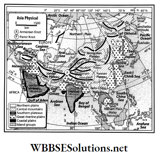
The central mountainous region:

In this part of the continent, a number of mountains radiate from the Pamir Knot and Armenian Knot.

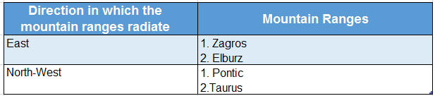
  1. The Himalayas, Karakoram, Kunlun, Tien Shan, Hindu Kush, Suleiman, Altyn Tagh, Altai, Sayan, etc. radiate from the Pamir Knot.
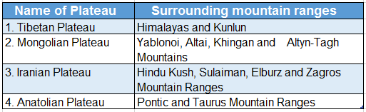
  2. Elburz, Pontic and Taurus mountains radiate from the Armenian Knot. A number of intermontane plateaus are also found in this region.  Tibet Plateau lies in between the Himalayan and Kunlun Mountain Ranges, Iranian Plateau lies in between the Hindu Kush and Sulaiman Ranges, Anatolia Plateau lies in between the Pontic and Tauras Mountain Ranges, etc.

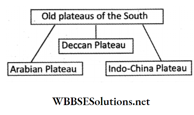
Low dissected plateaus of the south:

There are three ancient landmasses in the southern part of Asia-

  1. Arabian Plateau,
  2. Deccan Plateau,
  3. Indo-China Plateau.

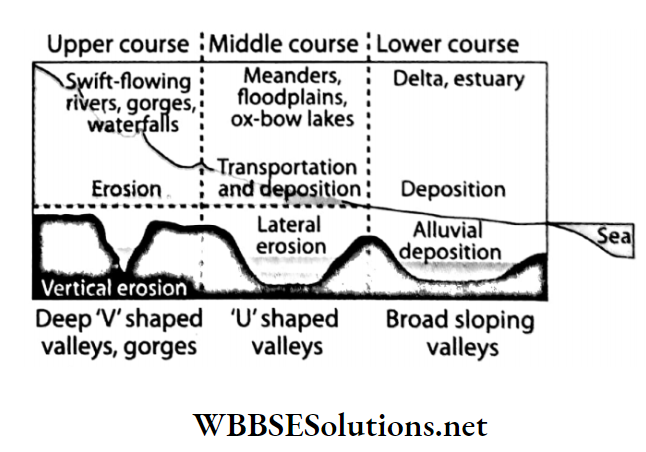
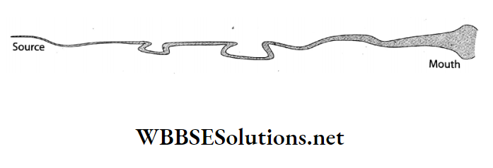
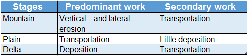
The course of the river explains the region’s slopes from west to east.

Riverine plains:

Rivers like Ob, Yenisei, Lena, Amu, Yangtze Kiang, Irrawaddy, Mekong, Ganga, Brahmaputra, Tigris and Euphrates have formed fertile plains along their basins. These plains are agriculturally prosperous as well as highly populated.

Coastal plains:

Asia is bounded on three sides by seas except on the west. Some parts of the coast are narrow while some are broad.

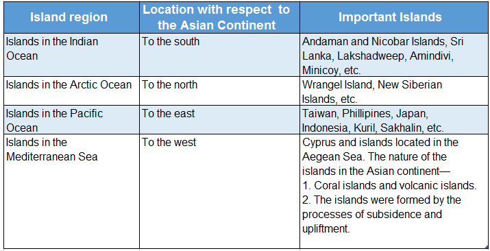
Island groups or archipelago:

There are innumerable volcanic, depositional and coral islands found in the Pacific and Indian Oceans.

For example- the Islands of Japan, the Indonesian Islands, the Kuril Islands, Islands of the Philippines, etc. Many islands are also found in the Arctic Ocean and the Mediterranean Sea.

For example, Greenland, Monumental Island in the Arctic Ocean and Ibiza, Majorca Island in the Mediterranean Sea.

WBBSE Solutions For Class 7 Geography Chapter 9 Topic A Revolution Of The Earth Physiography Of Asia

WBBSE Class 7 Geography Notes WBBSE Solutions For Class 7 History
WBBSE Solutions For Class 7 Geography WBBSE Class 7 History Multiple Choice Questions
WBBSE Class 7 Geography Multiple Choice Questions WBBSE Solutions For Class 7 Maths


Question 3. Describe the Northern Plains of Asia.
Answer:

The Northern Plains of Asia:

The Northern Plains of Asia extend from the Caspian Sea in the west to Bering Strait in the east and from Central Mountains in the south to the Arctic Ocean in the north. This plain covers about 20% of the landmass of Asia.

These plains have been divided into three parts according to their origin, structure and nature. They are-

1. Turan Lowlands:

Location:

The Turan Lowlands are located between the Caspian Sea and the Aral Sea.

Formation:

This part was originally formed by the upliftment of the sea floor and later deposition of sand from the Arctic Ocean separated it from the sea. This part is about 3m- 10m below sea level.

The scarcity of rainfall has led to the formation of two deserts-Karakum and Kyzylkum.

Important Definitions Related to Earth’s Revolution

2. Siberian Plains:

Location:

These plains extend from Ural Mountain in the west to Yenisei River Valley in the east.

Formation:

This region is formed by the sediments of Ob, Yenisei, and Lena and their distributaries. Glacial action has also been instrumental in the formation of this plain.

3. Eastern Uplands or Shield Region:

Location:

The Eastern Uplands extend from the Yenisei Valley in the west to Bering Strait in the east.

Formation:

Geologists think that the Shield Region was formed about 100 billion years ago. Later on, these lands became so consolidated that no terrestrial movement could disturb it.

However, the height of the shield has been reduced by rivers, glaciers and other weathering agents.

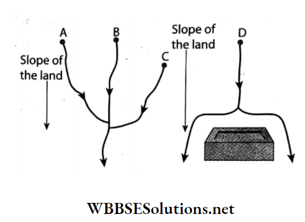
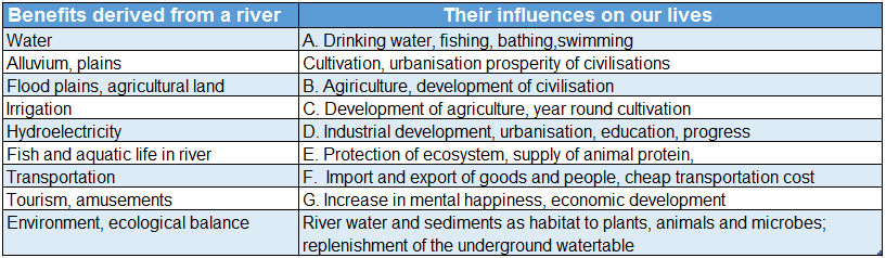
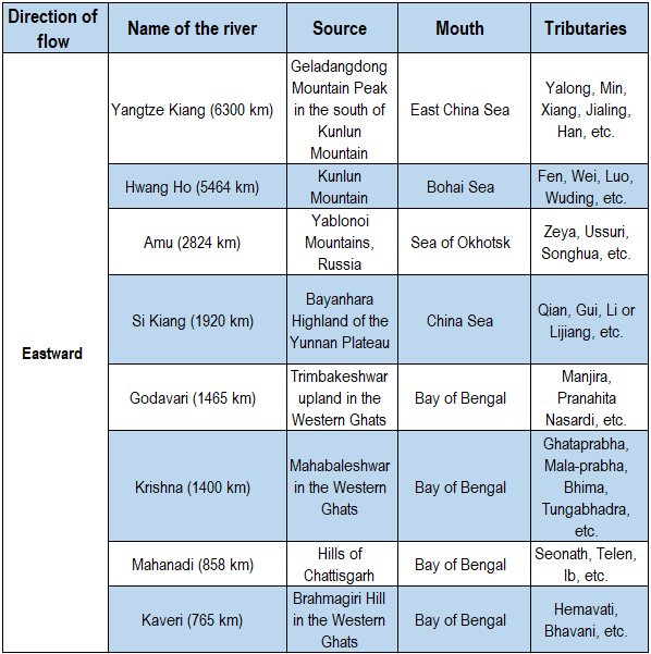
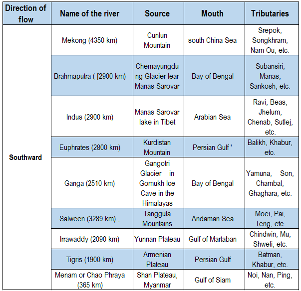
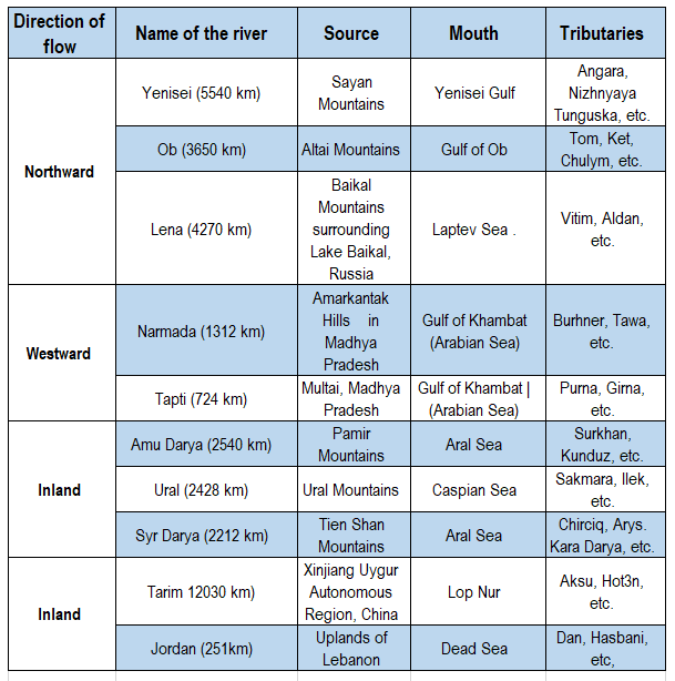
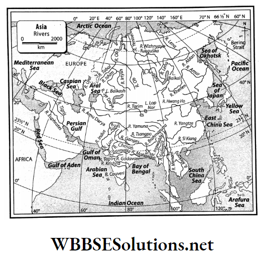
Question 4. Based on the direction of flow list the length, source, mouth and a few tributaries of some important rivers of Asia.
Answer:

List of some important rivers of Asia: Some important rivers of Asia are-

WBBSE Solutions For Class 7 Geography Chapter 9 Continent Of Asia Topic A Revolution Of The Earth List of some important rivers of Asia

WBBSE Solutions For Class 7 Geography Chapter 9 Continent Of Asia Topic A Revolution Of The Earth List of some important rivers of Asia 1

WBBSE Solutions For Class 7 Geography Chapter 9 Continent Of Asia Topic A Revolution Of The Earth List of some important rivers of Asia 2


WBBSE Solutions For Class 7 Geography Chapter 9 Topic A Revolution Of The Earth Rivers of Asia


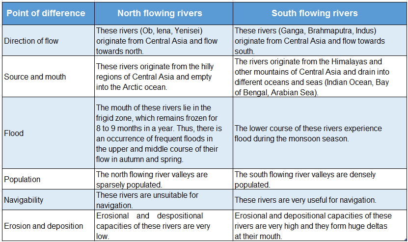
Question 5. Differentiate between north-flowing rivers and south-flowing rivers of Asia.
Answer:

Differences between north-flowing and south-flowing rivers of Asia:

The main differences between the north-flowing rivers and the south-flowing rivers of Asia are as follows-

WBBSE Solutions For Class 7 Geography Chapter 9 Topic A Revolution Of The Earth Differences between north and south flowing rivers of Asia


Question 6. Why does Asia have a diverse climate?
Answer:

Reasons for the diverse climate of Asia:

There are some reasons for diversity in the climate of Asia-

Latitude:

The continent of Asia extends from 10°S to 82°N. So its southern part lies in the torrid zone, the central part lies in the temperate zone and the northern part lies in the frigid zone.

Distance from the sea:

The continental climate is found in regions which are located at a distance of 2000 km-2500 km from the sea coast. In Tibet the summer temperature can reach as much as 40°C while in winter it can go much below the freezing point.

The parallelly maritime climate is experienced around the sea coasts.

Altitude:

Temperature decreases with altitude. So the temperature remains low in the mountainous regions throughout the year. The central mountainous region of Asia which has an average elevation of 4000m, experiences a cold climate.

Physiography:

Since there are high mountains extending from west to east in the central part of Asia, the cold winds from the north cannot enter the southern part. Similarly, the south-west monsoon winds coming from the south are unable to cross over to the north.

Question 7. Describe the features of any two types of climate found in Asia and show how they influence the natural vegetation.
Answer:

Any two types of climate found in Asia and their influence on natural vegetation: Two climatic regions of Asia are-

Equatorial climatic region:

Location:

This type of climate can be found in places located 10°N and S of the Equator in the countries of Indonesia, southern Malaysia, Sri Lanka, Maldives, Singapore, etc.

Features of climate:

  1. As the sun’s rays fall perpendicularly over here, the temperature remains high throughout the year. The average annual temperature is 25°C-30°C.
  2. Rainfall occurs throughout the year (200 cm-250 cm annually).
  3. In this region, only one season prevails i.e. summer.

Natural vegetation:

Features:

  1. This region has evergreen vegetation i.e. the trees do not shed their leaves altogether during any season.
  2. The trees are tall with stout trunks.
  3. A number of trees belonging to the same species grow together and several types of parasitic creepers, ferns and orchids grow around them.

Trees:

Rubber, mahogany, ironwood, rosewood and varieties of palms grow here.

Mediterranean climatic region:

Location:

This type of climate is found along the Mediterranean Coast of Asia in the countries of Turkey, Lebanon, Israel and Syria.

Features of climate:

  1. The coastal regions have a comparatively moist climate.
  2. Rainfall occurs in winter under the influence of westerly winds.
  3. Summer temperature is moderate (21°C-27°C).
  4. The average annual rainfall is 35 cm-75 cm.

Natural vegetation:

Features:

  1. The leaves are thick and covered with a waxy substance for protection from evaporation during the dry summer.
  2. Some trees have thick barks and juicy fruits.
  3. The roots are long and deep.

Trees: Cork, oak, pine, fir, olive and grapes.

Question 8. Discuss the relationship between the climate and natural vegetation of Asia.
Answer:

WBBSE Solutions For Class 7 Geography Chapter 9 Topic A Revolution Of The Earth relation ship between climate and Natural vegetation of asia


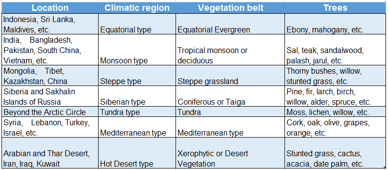
Relationship between climate and natural vegetation of Asia:

An intimate relationship exists between climate and natural vegetation. The nature and distribution of natural vegetation on the Earth’s surface depends on the elements of weather and climate like temperature, rainfall, humidity, etc.

The following table shows the distribution of natural vegetation on the basis of climate.


WBBSE Solutions For Class 7 Geography Chapter 9 Topic A Revolution Of The Earth Natural vegetation belts in Asia


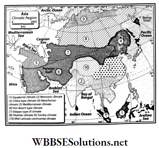
Question 9. Describe the location of the climatic regions of Asia.
Answer:

Location of the climatic regions of Asia:

On the basis of climatic characteristics, Asia can be divided into different climatic regions. Their locations are-

  • Equatorial climatic region: This region extends on both sides of the Equator from 10°N to 10°S encompassing the countries of Indonesia and Malaysia in the north and Sri Lanka, Maldives, Singapore, etc. in the south.
  • Monsoon climatic region: This region extends from 10°N to 30°N encompassing the countries of India, Bangladesh, Pakistan, the southern part of China, Thailand, Vietnam, etc.
  •  China-type climatic region: In the central and northern parts of China, South Korea and in certain parts of Japan, the existence of this climatic region can be seen.
  •  Manchurian climatic region: In the Manchuria region of China, the northern part of North and South Korea, etc. the existence of this climatic region can be seen.
  • Mediterranean climatic region: Countries like Syria, Lebanon, Turkey, Israel, Jordan, etc. lying between 30°N-35°N along the coast of the Mediterranean Sea fall under this climatic region.
  • Hot desert climatic region: The Arabian Desert, Thar Desert of India and Pakistan, Iraq, Iran, Kuwait, etc. experience this type of climate.
  • Steppe climatic region: The southwestern region of Siberia and the Mongolia Plateau fall under this climatic region.
  • Siberian climatic region: The Siberian region of Russia and a few areas of Sakhalin Islands fall under this climatic region.
  • Tundra climatic region: The Arctic Circle region of the continent experiences this climate.
  • Mid-latitude continental climatic region: The mountainous region of Central Asia falls under this climatic region.


WBBSE Solutions For Class 7 Geography Chapter 9 Topic A Revolution Of The Earth Climatic Regions in Asia

Question 10. Give the location and extent of the continent of Asia.
Answer:

The location and extent of the continent of Asia:

Asia, the largest continent in the world is located due east of the continents of Europe and Africa.

It extends from Cape Piai, Malaysia in the south (1°16′ S) to Cape Chelyuskin, Russia in the north (77°44’N) and from Cape Dezhnev, Russia in the east (169°40’W) to Cape Baba, Turkey (26°4’E) in the west.


WBBSE Solutions For Class 7 Geography Chapter 9 Topic A Revolution Of The Earth Location and extent of Asia


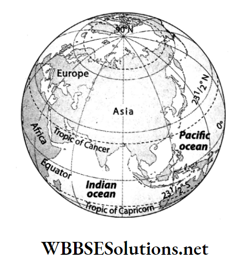
Due to its large east-west extension, when the sun rises in the western region, it is noon in the middle part and dusk in the extreme east of Asia.

Question 11. Write a brief note on the Pamir Knot.
Answer:

Pamir Knot:

  • Pamir Knot is the nodal point from which almost all the mountain ranges of Asia radiate in different directions. The mountain ranges radiating from Pamir Knot are Hindu Kush and Sulaiman to the west.
  • The Hindu Kush Range extends westwards as the Elbruz Mountain Range while the Sulaiman Range runs westwards first as Kirthar Range and then as the Zagros Mountains.
  • To the east of the Pamir Knot lies the Himalayan, Karakoram, Kunlun, Altyn Tagh and Tien Shan Ranges.


WBBSE Solutions For Class 7 Geography Chapter 9 Topic A Revolution Of The Earth Different mountains spreading out from Pamir knot

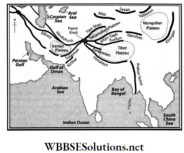
Question 12. Describe the central mountains of Asia.
Answer:

The central mountains of Asia:

Almost all the mountain ranges of Asia radiate mainly from two nodal points or knots.

These two knots are-

  1. Pamir Knot and
  2. Armenian Knot.

Mountain ranges radiating from Pamir Knot are-

WBBSE Solutions For Class 7 Geography Chapter 9 Topic A Revolution Of The Earth Mountain ranges radiating from Pamir Knot


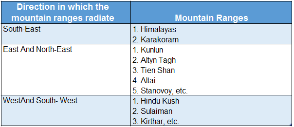
Mountain ranges radiating from Armenian Knot are-

WBBSE Solutions For Class 7 Geography Chapter 9 Topic A Revolution Of The Earth Mountain ranges radiating from armenian Knot

WBBSE Chapter 9 Continent Of Asia Topic A Revolution Of The Earth Short Question And Answers

Question 1. Mention the area and boundaries of the continent of Asia.
Answer:

The area and boundaries of the continent of Asia

  • Among the seven continents in the world, Asia ranks first according to area.
  • It covers an area of about 4,45,79,000 sq.km i.e. 8.7% of the earth’s total surface area and comprises 30% of the land area.
  • To the north of this continent is the Arctic Ocean and to its south is the Indian Ocean.
  • It is further bounded by the Pacific Ocean and Bering Strait in the east. Red Sea, Gulf of Aden, Africa, Mediterranean Sea, Europe, Ural River and Ural Mountains, Suez Canal in the west.

Question 2. Give an account of the southern plateaus of Asia.
Answer:

Southern plateaus of Asia:

There are three vast plateaus located in the southern part of Asia. These are-

  • Arabian Plateau: Located to the southwest of Asia. The general slope of the plateau is from southwest to north-east.
  • Deccan Plateau: Located in the southern part of India. To its west lies the Western Ghats or Sahyadri Range and to its east lie the Eastern Ghats. The slope of the plateau is from west to east.
  •  Indo-China Plateau and Yunnan Plateau: Both are parts of the same plateau lying in the southeastern part of Asia.

Question 3. Describe the Northern Plains of Asia.
Answer:

Northern Plains of Asia:

  • There is an extensive plain in the northern part of Asia which extends from the Caspian Sea in the west to the Bering Strait in the east and from the Central Mountain Belt in the South to the Arctic Ocean in the north.
  • This plain gently slopes from southeast to north-west. So, the rivers like Ob, Yenisei and Lena flow over this plain from south to north and flow into the Arctic Ocean.

On the basis of the variation in physiography at different places the Northern Plains of Asia can be divided into three parts-

  1. A Lowland of Turan,
  2. Siberian Plain,
  3. Eastern Uplands or Shield Plateau.

Question 4. What do you know about the Siberian Plain?
Answer:

Siberian Plain:

The largest lowland in the world is the Siberian Plain. It extends from the Yenisei River Valley in the east to the western boundary of the Asian continent in the west.

  • It has been formed by the depositional action of Ob, Yenisei, and Lena Rivers and glacial action.
  • Its mean elevation is 200 meters. It is wide near the Ural Mountains and gradually becomes narrow near the Yablonoi or Yablonovy and Stanovoy Mountains.
  • Due to the extremely cold temperature in the Arctic region, the rivers in their lower course i.e. in the northern part get frozen.
  • As the waters in the upper course of the rivers are unable to reach the sea, every year severe floods occur in this region, making it swampy and marshy.

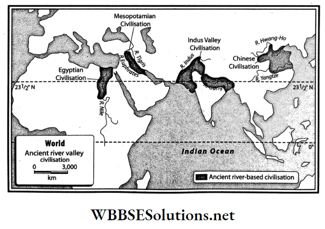
Question 5. Name a few alluvial plains of Asia.
Answer:

Alluvial plains of Asia:

In several parts of Asia, especially in the southeastern parts, many alluvial plains have formed.

Example

  1. The area of the Tigris- Euphrates river system or Mesopotamian Plain in Iraq.
  2. The Indus-Ganga-Brahmaputra Plain extends over India, Pakistan, and Bangladesh.
  3. The North China Plain was formed jointly by the Amu, Hwang Ho, Yangtze, and Si Kiang Rivers.
  4. The plain formed by the Irrawaddy and Salween Rivers in Myanmar,
  5. The plain is formed by the Menam and Mekong rivers lying within Laos, Cambodia, and Thailand.

Question 6. Give an account of the island groups of Asia.
Answer:

Island groups of Asia:

All around the continent of Asia, especially in the Pacific Ocean and the Indian Ocean, there are many big and small islands as well as archipelagos (groups of islands).

Some of these islands are continental islands and a few are oceanic islands. These are-

WBBSE Solutions For Class 7 Geography Chapter 9 Topic A Revolution Of The Earth Island groups of Asia.

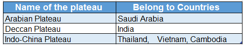
Question 7. Find out from the political map which countries do these three plateaus belong to.


WBBSE Solutions For Class 7 Geography Chapter 9 Topic A Revolution Of The Earth Old plateaus of the south
Answer:

WBBSE Solutions For Class 7 Geography Chapter 9 Topic A Revolution Of The Earth name of plateau and belong to countries


Question 8. What are the characteristics of the northward-flowing rivers in Asia?
Answer:

The characteristics of the northward flowing rivers in Asia are-

A major part of the northern part of Russia including the Arctic Ocean remains frozen for about 8-9 months.

So, the rivers flowing from the Central Mountain Belt of Asia namely Ob, Yenisei, and Lena in the south are unable to flow into the sea, as they are hindered by the snow. This hindrance results in the occurrence of frequent floods in the upper and middle course of the rivers.

  1. The rivers are unfit for navigation.
  2. Marshy lands are found along the river valleys
  3. The river valleys are sparsely populated.

Question 9. Why are the northward-flowing rivers of Asia flood-prone?
Answer:

The northward-flowing rivers of Asia flood-prone:

  • The northward-flowing rivers of Asia are flood-prone because-As the lower course and mouth of the rivers flowing across the Northern Plains of Asia are located in the frigid zone, they remain frozen for a greater part of the year.
  • But, the upper courses of these rivers are usually located in temperate regions (or comparatively warmer regions), where the river freezes only during winter.
  • So, if the mouths of the rivers remain frozen, the excess water flow due to heavy rain during spring and autumn in the upper course is unable to reach the lower course and drain through the mouth. Thus the river valleys are flooded.

Question 10. What are the features of the rivers of the Tundra region?
Answer:

The features of the rivers of the Tundra region:

The rivers which flow over the Tundra region of Asia are Ob, Yenisei, and Lena. The features of the rivers of the Tundra region are-

  1. The mouth of these rivers remains frozen almost throughout the year.
  2. The rivers have gentle gradients and have low flow velocities.
  3. Numerous large swamps have formed in the land areas near the river mouth due to flood.

Question 11. What are the characteristics of the southward-flowing rivers in Asia?
Answer:

The characteristics of the southward flowing rivers in Asia are-

  1. Most of the rivers in South Asia (except a few rivers like Tigris- Euphrates, etc.) flow through the monsoon climatic region.
  2. Though these rivers receive snow-melt water from mountainous regions, but most of them are rain-fed (monsoon rains) along the course.
  3. Floods occur in the lower course of the rivers during monsoon season.
  4. The rivers are perennial.
  5. The rivers are used for irrigation and navigation.
  6. The river valleys are densely populated.

Question 12. What are the characteristics of the eastward-flowing rivers in Asia?
Answer:

The characteristics of the eastward flowing rivers in Asia are-

  1. The source of the principal eastward-flowing rivers is the Central Asian Mountain Belt.
  2. The eastward-flowing rivers namely Amu, Hwang Ho, Yangtze, and Si Kiang flow over China and after crossing a long path flows into the Pacific Ocean.
  3. The rivers deposit alluvium in their lower course and form fertile plains. These regions are highly developed in agriculture and industry.
  4. So, the river valleys in this region are densely populated. The principal rivers in this region are Hwang Ho, Yangtze Kiang, etc.

Question 13. What are the characteristics of the westward-flowing rivers in Asia?
Answer:

The characteristics of the westward-flowing rivers in Asia:

Among the westward-flowing rivers in Asia, the principal rivers are the Narmada and Tapti of India. The characteristics of these rivers are-

  1. These rivers are rain-fed and have strong currents in the monsoon season.
  2. Both rivers flow through rift valleys before draining into the sea.
  3. There are no deltas present at the mouth of these rivers.
  4. These rivers are not perennial.
  5. These rivers have steep slopes. and flow into the Arabian Sea.

Question 14. Name the inland rivers of Asia.
Answer:

Inland rivers of Asia:

  • The rivers whose courses are confined within a country or continent i.e. the rivers which do not flow into any waterbody or sea outside its source region are called inland rivers.
  • Some rivers of this type located within Asia are Amu Darya, Syr Darya, Ural, Tarim, Jordan, Helmand, etc. Luni River in India is an example of an inland river.

Question 15. What are the characteristics of the inland rivers of Asia?
Answer:

The characteristics of the inland rivers of Asia are-

  1. The inland rivers of Asia like Amu Darya, Syr Darya, Ural, Tarim, etc. receive water only from rain.
  2. The rivers are very shallow for most of the year.
  3. Their lengths are comparatively shorter.
  4. They flow into some waterbody within the country of their origin.

Question 16. Why are the central mountains of Asia called a water divide?
Answer:

The central mountains of Asia called a water divide:

  • There are numerous long and high mountain ranges namely Pontic, Taurus, Elburz, Karakoram, Himalayas, Altyn Tagh, Tien Shan, etc. and intermontane plateaus namely Tibetan Plateau, Iranian Plateau, etc. in Central Asia.
  • These extend from west to east and then towards the northeast of Central Asia. This mountain belt is the source region of many important rivers of Asia.

For example, Ob, Yenisei, and Lena to the north, Amu, Yangtze Kiang, and Hwang Ho to the east, and Euphrates- Tigris, Indus, Ganga, Brahmaputra, Irrawaddy, etc. to the south.

This long mountainous belt guides the courses of the rivers and thus is referred to as the ‘Water divide of Asia.

Examples of Real-Life Applications of Revolution Knowledge

Question 17. Why does Asia have such a diverse climate?
Answer:

Asia have such a diverse climate:

The different types of climate found in different parts of the Asian continent are mainly due to the following factors-

  1. Effect of latitudes,
  2. Distance from sea,
  3. Influence of physiography especially the Central Asian Mountain Belt,
  4. Influence of monsoons and westerlies,
  5. Influence of hot and cold ocean currents,
  6. Convectional rainfall in the equatorial region throughout the year and
  7. Influence of the altitude of the Central Asian Mountain Belt.

Question 18. How does latitude influence the climate of Asia?
Answer:

Latitude influence the climate of Asia:

  • The Asian continent extends from 1°16′ south latitude in the south to 77°44′ north latitude in the north. This vast north-south difference of latitudes in Asia results in the variation of temperature across the continent.
  • As the southern part of this continent receives vertical rays of the Sun the temperature remains quite high almost throughout the year.
  • Whereas, the northern part of the continent receiving oblique rays of the Sun have lower temperature throughout the year.

Question 19. How does distance from the sea influence the climate of Asia? Or, The central part of Asia is far away from the seas or oceans. So how do you expect the climate there to be?
Answer:

The central part of Asia is far away from the seas or oceans:

  • The central part of Asia is about 2500 km away from the sea on either side.
  • As the effect of the sea does not reach the interior of the continent, this region experiences extreme climate i.e. the difference between the minimum temperature in winter and maximum temperature in summer is very huge.
  • Whereas, the coastal areas experience moderate climate i.e. the difference between the minimum temperature in winter and maximum temperature in summer is less.

Question 20. What are the characteristics of an equatorial type of climate in Asia?
Answer:

The chief characteristics of an equatorial type of climate in Asia are-

  1. There is no variation in seasons as the climate is hot and humid i.e. high temperature and high rainfall is prevalent throughout the year.
  2. The mean annual temperature ranges from 25°C to 30°C.
  3. The annual rainfall ranges from 200 cm to 250 cm or more. Convectional rainfall occurs throughout the year, mostly in the afternoons.
  4. Due to high amount of water vapour in the air, instability exists in the weather.
  5. Rainfall occurs every day at 4 pm in the afternoon and hence, it is called 4 ‘o’clock rain.

Question 21. What are the characteristics of monsoon-type climate in Asia?
Answer:

The chief characteristics of monsoon-type of climate in Asia are-

  1. There exists a cycle of seasons, namely
    1. Summer,
    2. Monsoon,
    3. Autumn and
    4. Winter.
  2. Summers are hot and humid, while winters are mild and dry.
  3. The average temperatures during summers varies between 20°C-28°C and 15°C -20°C during winters.
  4. The southwest monsoon winds blowing from the sea, carry moisture and cause rainfall.
  5. The mean annual rainfall ranges from 100 cm to 200 cm. The foothill regions receive comparatively higher rainfall.

Question 22. What are the characteristics of China type of climate in Asia?
Answer:

The chief characteristics of this type of climate are-

  1. Summers are wet and mildly hot and winters are dry and cool.
  2. The average temperature in summer is 30°C and that in winter ranges between 4°C -12°C.
  3. The winds which enter this region in summer usually blow from the sea, carrying moisture and resulting in sufficient rainfall. The annual rainfall is about 100 cm.

Question 23. What are the characteristics of the Mediterranean type of climate in Asia?
Answer:

The chief characteristics of the Mediterranean type of climate are described as below-

  1. Moist westerlies blow over this region in the winter season causing rainfall. Although the amount is less, it averages between 30cm 50cm annually.
  2. Dry northeast trade winds blow over this region in the summer causing no rainfall.
  3. It is neither too hot nor too cold at any time of the year. The average temperature in the summers is between 21°C -27°C and in the winters, between 5°C -10°C.
  4. Snowfall occurs in the mountain regions during winter.

Question 24. What are the characteristics of the hot desert type of climate in Asia?
Answer:

The characteristics of the hot desert type of climate are-

  1. An extreme type of climate prevails in this region.
  2. The diurnal range of temperature in the region is high-about 25°C to 35°C. The maximum temperature during the day averages between 40°C-45°C and at night, the temperature falls down to about 8°C.
  3. The hottest place in Asia is Jacobabad in Pakistan, where the maximum temperature recorded has been 52°C.
  4. The average temperature in summers is about 30°C -35°C and in winters about 15° -25°C.
  5. Dust storms are common during the day.
  6. The average annual rainfall ranges between 10cm-25 cm and in some years even this amount of rainfall does not occur.

Question 25. What are the characteristics of the Siberian-type of climate?
Answer:

The characteristics of the Siberian-type of climate:

The Siberian type of climate extends from 40°-45° north latitudes to the Arctic Circle in the Siberian region of Russia. The characteristics of this type of climate are-

  1. Winters are long and very cold while summers are short and chilly.
  2. The average annual temperature during summer is about 15°C while during winters the temperature remains below the freezing point.
  3. There is hardly any rainfall but it snows heavily. This heavy snowfall during the winter results in the surface remaining covered with snow for 7 to 8 months in a year.
  4. Intense snow storms or blizzards blow over this region during winter.

Question 26. What are the characteristics of a Tundra type of climate?
Answer:

The characteristics of a Tundra type of climate:

The Tundra type of climate prevails over the northern part of the Arctic Circle (661°N) i.e., towards the north of the continent of Asia.

  1. This region mainly falls within Russia. Some important characteristics observed in this type of climatic region are-
  2. The winters are severely cold and very long. Heavy snowfall occurs for 8-9 months in a year and the surface remains covered with snow almost throughout the year.
  3. Darkness prevails continuously for months during the winter season.
  4. Summer season prevails only for 2-3 months. The average temperature during summer ranges between 0°C-10°C. So, the summer season is also pretty cold.
  5. Sometimes little rainfall occurs in the summer season due to temperate cyclones.

Question 27. What are the characteristics of the Steppe type of climate in Asia?
Answer:

The chief characteristics of the Steppe type of climate are-

  1. An extreme type of climate prevails in this region.
  2. Short summers and long winters exist.
  3. The average temperature in summers varies between 33°C-38°C and in winters, it remains around -20° C.
  4. Little rainfall occurs in the summer season (average 12.5cm-25cm) and snowfall occurs in the winter.
  5. The diurnal and annual range of temperature are very high.
  6. The region remains snow-covered from November to March and thaws in the month of April.

The characteristics of this climate are-

  1. The summer temperature is comparatively higher than the China type of climatic region located in the south, and the winters are cold. The average annual temperature in summer is 24° C to 31°C and in winter is -25°C to -30° C.
  2. Mild short summers prevail. Moderate rainfall (average 75 cm) occurs during the summers.
  3. There is abundant snowfall during the winter.

Question 28. What are the characteristics of continental mid-latitudinal climates?
Answer:

The characteristics of continental mid-latitudinal climate are-

  1. As the regions experiencing this type of climate are bounded by mountains on all sides, moist air is unable to reach its interior. Thus, dry conditions prevail due to a lack of rainfall.
  2. As a result of this dry weather, the summers are quite hot and the winters are severely cold i.e. extreme type of climate prevails.
  3. As the amount of rainfall is very less, the condition is a more hot desert type but, being located a little north i.e. in the temperate regions the temperature does not rise as much as that of the hot deserts. Some temperate deserts have formed in this region, for example-Gobi Desert and Taklamakan Desert.

Question 29. What are the general characteristics of the climate prevailing over Asia?
Answer:

The general characteristics of the climate prevailing over Asia are-

  1. Extreme variation in climate,
  2. A considerable rise in temperature during the summer,
  3. Considerable fall in temperature during the winter,
  4. The arrival of warm and moist southwest monsoons.
  5. The arrival of dry and cold north-east monsoons,
  6. Rainfall due to the influence of westerlies, etc.

Question 30. What are the chief characteristics of the equatorial evergreen forests?
Answer:

The chief characteristics of equatorial evergreen forests are-

  1. Due to very high temperatures and adequate rainfall throughout the year, trees are tall (height: 30m-45m), with broad leaves.
  2. The trees yield hard wood which is used for making furniture.
  3. The trees have green leaves throughout the year and are thus, called evergreen trees.
  4. Due to the presence of plank buttress roots, the trees get additional support and stability to stand erect.
  5. As the trees usually form a thick canopy, the sunlight is prevented from reaching the forest floor. So, the forests are dark, damp, and gloomy.
  6. These forests are known as the ‘Lungs of the World’.
  7. The vegetation density of these forests is the highest. The important trees are mahogany, rosewood, ironwood, teak tables, rubber, cocoa, and cinchona.

Question 31. Give reasons for the predominance of evergreen trees with broad leaves in the equatorial natural vegetation belt of Asia.
Answer:

  • The equatorial natural vegetation belt in Asia experiences abundant rainfall throughout the year. The excess amount of rainwater is absorbed by the tall plants, which usually have broad leaves to lose it through transpiration.
  • A large number of stomata are present on these bigger-sized leaves making it easier to lose the excess water through transpiration. Moreover, due to this excessive rainfall throughout the year, the trees do not dry up or shed their leaves at one particular time.
  • Rather, they shed their leaves in small quantities all year round, retaining their evergreen character. Thus, there is a predominance of evergreen trees in this forest.

Question 32. What are the characteristics of Mediterranean forests in Asia?
Answer:

The characteristics of Mediterranean forests in Asia are –

  1. The tree have long roots which reach great depths in the soil in search of water.
  2. The stem of the trees remain covered with a thick bark and the thick leaves have a wax-like coating.
  3. These forests are sparse and scattered
  4. Due to lack of sufficient water, climbers, bushes, and drought-immune trees grow in this forest. The important trees are olive, grapes, lemon, cork, oak, laurel, lavender, rosemary, etc.

Question 33. What are the characteristics of desert-type of vegetation or xerophytic vegetation in Asia?
Answer:

The characteristics of the desert type of vegetation in Asia are-

  1. The trees have very long roots.
  2. The leaves of the xerophytic plants are usually thin and small and mostly are thorns.
  3. Due to the severe scarcity of water, very few types of plants grow in the deserts.
  4. Their leaves and stems are succulent.
  5. Very few stomata are present on the leaves of these trees.
  6. These trees are adapted to the scarce water conditions prevalent in a desert region. Thorny bushes, date, palm, prickly bean, and acacia grow here.

Question 34. What are the chief characteristics of Taiga forests?
Answer:

The chief characteristics of the Taiga forests in Asia are-

  1. The Taiga forests are dominated by coniferous trees.
  2. The trees yield softwood, which is used as timber and for making paper and rayon.
  3. The canopy of these trees have a cone-like structure with fewer branches and the trees grow straight upwards.
  4. The forest floor is devoid of climbers and weeds.
  5. The leaves of these trees are short and needle-shaped. The important trees are pine, fir, spruce, larch, birch, cedar, and willow.

Question 35. The average altitude of Central High- lands of Asia is more than 4000m. Then what would be the temperature there?
Answer:

The average altitude of Central High- lands of Asia is more than 4000m.

  • We know that according to the normal lapse rate of temperature, the temperature decreases by 6.4°C per 1000m of ascent from the sea level.
  • So, the temperature at an altitude of 4000m would be 6.4°C x 4 = 25.6°C less than the temperature at sea level.

Question 36. What is meant by the Dead Sea or ‘The Sea of Death’?
Answer:

The Sea of Death:

  • There is a deep saltwater lake, i.e. around 430 meters below the sea level located at the boundary of Jordan and Israel in West Asia called the Dead Sea or the Sea of Death. This lake has 330 grams of salt per 1000 grams of water.
  • This high salinity makes for a harsh environment in which no animal can survive or flourish, hence its name. This lake is also called the Salt Sea.

Question 37. What do you mean by Eurasia?
Answer:

Eurasia:

Eurasia is the combined continental landmass of Europe and Asia. In the absence of any geographical boundary (except Ural Mountains, Ural River and Caspian Sea) between the continents of Europe and Asia; this vast landmass has formed.

Question 38. What are the physiographic divisions of Asia?
Answer:

According to variations in physiography, Asia can be divided into six physiographic divisions.

They are-

  1. The Northern Plains,
  2. The Central Mountains,
  3. The Southern Plateaus,
  4. The Great Riverine Plains,
  5. The Coastal Plains,
  6. The Island Groups.

Question 39. Name the intermontane plateaus of central Asia.
Answer:

The important intermontane plateaus in central Asia are

WBBSE Solutions For Class 7 Geography Chapter 9 Topic A Revolution Of The Earth Intermontane plateaus of central Asia


Question 40 Write a note on the Arabian Plateau.
Answer:

Arabian Plateau:

  • The Arabian Plateau located to the southwest of Asia gently slopes eastward from the west and merges with the narrow plains along the Persian Gulf.
  • Most of the Arabian Plateau region is dry and rainless. There is no river in this region.

Question 41. Write a note on the Deccan Plateau.
Answer:

Deccan Plateau:

  • The Deccan Plateau located in the southern part of India is made up of old igneous rocks and lava flows from volcanoes.
  • As a result of prolonged erosion, the plateau has become dissected and wavy (with a number of uplands and lowlands).
  • The important eastward-flowing rivers in this plateau region are Mahanadi, Godavari, Krishna, and Kaveri. The westward-flowing rivers are Narmada, Tapti, etc.

Question 42. Write what you know about the Indo- China Plateau.
Answer:

Indo- China Plateau:

  • The Indo-China Plateau, located to the southeast of Asia covers parts of countries like Thailand, Laos, Cambodia, Myanmar, and Vietnam.
  • This plateau merges with the Yunnan Plateau and gently slopes from north to south.
  • The rivers draining this plateau are Salween, Mekong, Xi, Menam or Chao Phraya, etc.

Question 43. Write a note on the highlands of the east or Shield Plateau.
Answer:

Highlands of the east or Shield Plateau:

  • To the northeast of the Northern Plains of Asia lie the highlands of the East or Shield Plateau. It extends from the Bering Strait in the east to the Yenisei River Valley in the west.
  • These are the remnants of an ancient and dissected plateau. Its mean elevation is comparatively higher and is also known as the Angara Shield of the West Siberian Plain.

Question 44. Write a note on the Lowlands of Turan.
Answer:

Lowlands of Turan:

  • The Lowlands of Turan or Turan Plain lies to the southwest of the Northern Plains of Asia.
  • It covers southwest Kazakhstan and north-western parts of Uzbekistan and Turkmenistan.
  • Within this lowland lies the Caspian Sea and the Aral Sea. The Amu Darya and the Syr Darya rivers drain this plain.
  • Some of the places in this region are about 8-9 meters below sea level. There are two deserts in this region namely Karakum and Kyzylkum.

Question 45. Divide the rivers of Asia according to the direction in which they flow.
Answer:

According to the direction of flow, the rivers of the Asia can be classified into five types.

These are-

  1. Northward flowing rivers, for example. Ob, Lena;
  2. Southward flowing rivers, for example, Mekong, Indus, Brahmaputra;
  3. Eastward flowing river; example, Amu, Hwang Ho;
  4. West-ward flowing river, for example, Narmada, Tapti;
  5. Inland rivers, for example, Syr Darya, Amu Darya.

Question 46. Write a note on Sat-El-Arab.
Answer:

Sat-El-Arab:

The confluent stream of the River Tigris (rising from the Armenian Plateau) and River Euphrates (rising from Kurdistan Mountain) is known as Sat-El-Arab. This confluent stream then drains into the Persian Gulf.

Question 47. Name the rivers of the monsoon climatic region of Asia.
Answer:

The southward-flowing rivers of Asia namely Ganga, Brahmaputra, Irrawaddy, Salween, etc. flow through the monsoon climatic regions. Floods are common in these rivers during monsoon season.

Question 48. Describe the course of the Hwang Ho or Yellow River.
Answer:

  • The Hwang Ho River originates from the Kunlun Mountains in China. At first, it flows northwards and then towards the east.
  • The river flows into the Bohai Sea after crossing a length of 5464 km.
  • As the water of this river has yellow loess soil mixed in it, it is yellow in colour and hence the name Yellow River. Fen, Wei, Luo, Wuding, etc. are some of its tributaries.

Question 49. Divide Asia into different climatic zones. Or, What are the different types of climate which can be observed from south to north in Asia?
Answer:

According to the variation in climate, Asia can be divided into 10 main climatic zones.

These are-

  1. Equatorial climatic zone,
  2. Monsoon climatic zone,
  3. Zone of China-type climate,
  4. Manchurian climatic zone,
  5. Mediterranean climatic zone,
  6. Zone of hot desert type of climate,
  7. Mid-latitude continental climatic zone,
  8. Steppe type of climatic zone,
  9. Siberian climatic zone,
  10. Tundra climatic zone.

Question 50.  Which regions in Asia experience a Steppe type of climate?
Answer:

  • A steppe type of climate prevails over the grasslands of the Anatolian Plateau in the west and the eastern part of the Gobi Desert in the east of Asia.
  • These regions receive little rainfall and snow-melt water and thus, only grasses grow here. These grasslands are called Steppe.

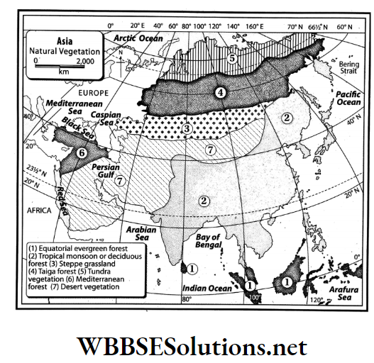
Question 51. What are the different types of natural vegetation found in Asia?
Answer:

  • Natural vegetation of a region is highly influenced by the prevailing climatic conditions.
  • Thus, with increasing differences in temperature and rainfall across the continent, a wide variety of natural vegetation is found in different parts of Asia.

According to this variation, natural vegetation across this continent can be divided into 7 types-

  1. Equatorial evergreen forest,
  2. Tropical monsoon or deciduous forest,
  3. Steppe grassland region,
  4. Taiga forest region,
  5. Mediterranean forests,
  6. Tundra vegetation,
  7. Desert vegetation.

Question 52.  Mention the characteristics of tropical monsoon or deciduous forests in Asia.
Answer:

  • The characteristics of tropical monsoon or deciduous forests in Asia are- The trees are not very tall (height: 10m-15m).
  • The trees lose all their leaves in winter and hence, the name is deciduous. (The term deciduous means ‘tending to fall off’.)
  • These forests have dense undergrowth of herbs, shrubs, and bushes. The upper stratum of the trees are clustered.

Question 53. Mention the characteristics of Tundra vegetation in Asia.
Answer:

The characteristics of Tundra vegetation in Asia are-

  1. Big trees do not grow as the surface remains covered with snow for most of the year.
  2. During the short summers when the snow melts, a few plants like shrubs and mosses grow.
  3. Towards the southern part of the Tundra vegetation belt, a few trees are found. Moss, lichen, algae, etc. grow in the Tundra region.

Question 54. Why is the Yangtze Kiang Basin densely populated?
Answer:

The Yangtze Kiang Basin is the most densely populated region in China. Although the basin covers one-fifth of the total area of China (i.e. about 18 lakh sq. km), it is the home to one-fourth (about 30 crores) of the total population of China.

The reasons for the high population density in this region are-

  1. Rich in agriculture,
  2. Rich in mineral resources,
  3. Industrially developed,
  4. The developed transport system,
  5. Accessibility to large seaports,
  6. Pleasant climate, etc.

Question 55. Mention the characteristics of the Steppe Grasslands of Asia.
Answer:

The characteristics of Steppe Grasslands of Asia are-

  1. Very few trees because of low rainfall.
  2. Short and soft grasses that flourish in severe cold and dry winter.
  3. Some big trees are found in high mountainous regions and near the river banks.

WBBSE Chapter 9 Continent Of Asia Topic A Revolution Of The Earth Very Short Question And Answers

Question 1. Which is the largest continent in the world in terms of area?
Answer: Asia.

Question 2. Which is the highest plateau in the world?
Answer: Pamir Plateau.

Question 3. Which is the deepest lake in the world?
Answer: Lake Baikal.

Question 4. Which is the coldest place in the world?
Answer: Oymyakon, Russia (Siberia).

Question 5. Name the largest delta in the world.
Answer: Ganga-Brahmaputra Delta.

Question 6. What is the combined continental landmass of Europe and Asia called?
Answer: Eurasia.

Question 7. Which is the largest plateau in the world located between the Himalayan and Kunlun Mountain Ranges?
Answer: Tibetan Plateau.

Question 8. In which direction does the Ob, Yenesei, and Lena River flow?
Answer: Northward direction.

Question 9. Which one is the longest among the north flowing rivers?
Answer: River Yenisei.

Question 10. Which of the south-flowing rivers of Asia originates near Manas Sarovar of Tibet and falls in Bay of Bengal?
Answer: Brahmaputra River.

Question 11. Which is the longest south-flowing river of Asia? What is the length of that river?
Answer: Mekong River (435 km).

Question 12. Which is the longest river of Asia?
Answer: Yangtze Klang.

Question 13. Which river is called the ‘Sorrow of China’?
Answer: Hwang Ho River.

Question 14. Which river of Asia is known as ‘The River of Golden Sands’?
Answer: Yangtse River.

Question 15. Which river is known as the ‘Yellow River’?
Answer: Hwang Ho River.

Question 16. Name two east-flowing rivers of Asia which empty into the China Sea.
Answer: Yangtze Kiang and Si-Kiang.

Question 17. What name is given to the Hwang Ho River because of the yellow colour of its water in the lower course arising from loess being carried downstream?
Answer: Yellow River.

Question 18. Name the inland river of India.
Answer: Luni River.

Question 19. Which climatic region in Asia is characterized by very high temperature and humidity, and with no seasonal variations?
Answer: Equatorial climate region.

Question 20. Which climatic region in Asia is characterized by dry summers and wet winters?
Answer: Mediterranean climate region.

Question 21. Name the forestland characterized by coniferous trees, found in the northern part of Russia i.e. in the Siberian region.
Answer: Taiga.

Question 22. Name the type of grassland found in central Asia and in some parts of Anatolia.
Answer: Steppes.

Question 28. How are the Mediterranean forests and woodlands in Asia distributed?
Answer:

The Mediterranean forests and woodlands are found in the countries surrounding the Mediterranean Sea namely Lebanon, Israel, Palestine, and Syria.

Question 29. How is the desert type of vegetation in Asia distributed?
Answer:

The desert type of vegetation is found in arid, hot stretches of this continent such as in the Arabian Desert in Saudi Arabia, the Thar Desert in India and Pakistan, the Taklamakan Desert in China, and the Gobi Desert in Mongolia.

Question 30. Where is the Taiga forest located in Asia?
Answer:

The Taiga forests are found in the northern part of Asia, mainly in the heavy snowfall regions of Siberia.

Question 31. How is the Tundra vegetation in Asia distributed?
Answer:

A concentration of Tundra vegetation is found in the extreme north of the Siberian landmass in Russia, bordering the Arctic Circle.

Question 33. Where are the Steppe Grasslands located in Asia?
Answer:

The Steppe Grasslands are found in the regions of low rainfall in central Asia namely the northern part of the Turan Plain and the foothill region of the Khingan and Yablonovy Mountain Ranges.

Question 34. Where do we find monsoon climatic regions in Asia?
Answer:

The countries namely India, Bangladesh, Myanmar, Laos, Cambodia, Vietnam, and the southern parts of China and Japan which lie between 10° N and 30° N parallels of Asia fall within this tropical monsoon climatic zone.

Question 35. Where do we find China’s type of climate in Asia?
Answer:

The China type of climate is found in the eastern part of the Asian continent namely, the central part of China, the southern part of South Korea, and the central part of southern Japan.

Question 36. Where do we find the Mediterranean type of climate in Asia?
Answer:

The Mediterranean type of climate is observed in the western parts of Asia i.e. namely Syria, Lebanon, Jordan, Israel, Turkey, Palestine, etc. which are situated along the coast of the Mediterranean Sea.

Question 37. Give the extent of the hot desert-type climate in Asia.
Answer:

The hot desert type of climate is prevalent over the south-western parts of Asia i.e. the Arabian Desert, Thar Desert of India and Pakistan, Iraq, Iran, Kuwait, etc. In this type of climate, very high temperature and very less rainfall is experienced.

Question 38. What are the characteristics of the Manchurian type of climate?
Answer:

Manchuria (north of China), the northern part of North and South Korea, the Sakhalin Island of Russia, and the northern part of Japan is situated in the Manchurian type of climatic region.

Question 39. Where do we find equatorial climatic regions in Asia?
Answer:

The southern part of Asia; i.e. regions located near the Equator (between 10° N to 10° S) experience the equatorial type of climate.

For example, Malaysia, Indonesia, Maldives, Singapore, Sri Lanka, Java, Borneo, Sumatra, etc.

Question 40. Where do we find the mid-latitudinal continental climate in Asia?
Answer:

The intermontane plateaus located in the central part of Asia are affected by a mid-latitudinal continental climate. Iran, Turan, Tibet, the region of the Gobi Desert lie within this climatic region.

Question 41. Name the highest and the lowest point on the Earth’s surface.
Answer:

The highest point on the Earth’s surface is Mt. Everest (8848m above sea level) and the lowest point on the Earth’s surface is Dead Sea (402m below sea level).

Question 42. Give the location of the equatorial evergreen forests in Asia.
Answer:

The equatorial evergreen forests are found between 5° -10° N/S latitudes in southeast Asia.

For example- Indonesia, Malaysia, Myanmar, West Papua province (Indonesia), Celebes, Philippines, Sri Lanka, and the southern edge of India, etc.

Question 43. Give the location of the tropical monsoon or deciduous forests in Asia.
Answer:

The tropical monsoon or deciduous forests are predominant in countries like India, Bangladesh, Myanmar, Thailand, Laos, Vietnam, Cambodia, the Malay Peninsula, and South-East China, etc. in Asia.

WBBSE Chapter 9 Continent Of Asia Topic A Revolution Of The Earth Fill In The Blanks

Question 1. The largest lake in Asia is __________.
Answer: Caspian Sea

Question 2. The coniferous forests in Russia are called __________.
Answer: Taiga

Question 3. The most low-lying place on Earth is __________.
Answer: Dead Sea

Question 4. The __________ Plateau is also known as the Roof of the World.
Answer: Pamir

Question 5. The Dead Sea is also known as __________.
Answer: Salt Sea

Question 6. The wettest place in Asia is __________.
Answer: Mawsynram

Question 7. The largest continent in the world is __________.
Answer: Asia

Question 8. The Aral Sea is a __________ water lake.
Answer: Saline

Question 9. __________ range radiates to the west from the Pamir Knot.
Answer: Hindu Kush

Question 10. The Pontic and the Taurus Mountains Ranges have originated from the __________ Knot.
Answer: Armenian

Question 11. The __________ Plateau lies between the Pontic and the Taurus Mountain Ranges.
Answer: Anatolian

Question 12. The Deccan Plateau in India is an example of __________ plateau.
Answer: Lava

Question 13. The Caspian Sea and Aral Sea are located in the __________ Basin.
Answer: Turanian

Question 14. Ob River flows through a __________ region.
Answer: Cold

Question 15. The Yenisei River flows into the __________.
Answer: Yenisei Gulf

Question 16. The __________ flowing rivers of the Asian continent are flood-prone.
Answer: Northward

Question 17. Ob, Yenisei, and Lena are __________flowing Rivers.
Answer: Northward

Question 18. Among the northward-flowing rivers, River _____ is the longest.
Answer: Yenisei

Question 19. The Ganga River has originated from the __________ glacier.
Answer: Gangotri

Question 20. The Indus River flows into the __________.
Answer: Arabian Sea

Question 21. Among the southward-flowing rivers, River __________ is the longest.
Answer: Mekong

Question 22. __________ is the river formed by the confluence of the rivers Tigris and Euphrates.
Answer: Sat-El-Arab

Question 23. Yangtze River originates from the glaciers of the __________ mountain peak.
Answer: Geladangdong

Question 24. The __________ River is known as the ‘Golden Sanded River’ in Asia.
Answer: Yangtze

Question 25. The __________ River has originated from a glacier in the south-western part of the Geladangdong peak in the south of the Kunlun Mountain Range.
Answer: Yangtze

Question 26. The __________ River in Asia is also known as the Yellow River.
Answer: Hwang Ho

Question 27. __________ is the longest river of Asia.
Answer: Yangtze

Question 28. Amu Darya River flows into the __________ Sea.
Answer: Aral

Question 29. India, located in the southern part of Asia experiences __________ climate.
Answer: Monsoon

Question 30. The trees of the __________ forests have wax-coated leaves.
Answer: Mediterranean

WBBSE Chapter 9 Continent Of Asia Topic A Revolution Of The Earth True Or False

Question 1. The highest mountain peak in Asia is Mt. Everest.
Answer: True

Question 2. The Aral Sea is a saline lake.
Answer: True

Question 3. The coldest place in Asia is Jacobabad.
Answer: False

Question 4. Manas Sarovar is located on the Pamir Plateau.
Answer: False

Question 5. The deepest lake in Asia is Lake Baikal.
Answer: True

Question 6. The Deccan Plateau is an intermontane plateau.
Answer: False

Question 7. Cacti and shrubs are found in the polar regions.
Answer: False

Question 8. Kunlun and Altyn-Tagh mountain ranges radiate towards the west from the Pamir Knot.
Answer: False

Question 9. The Tibetan Plateau lies between the Himalayan and the Kunlun Mountain Ranges.
Answer: True

Question 10. The Zagros and Elburz Mountain Ranges radiate towards the east from the Armenian Knot.
Answer: True

Question 11. One of the important rivers in Asia that flow into the Pacific Ocean is Lena.
Answer: False

Question 12. The longest river in Asia is the Yangtze.
Answer: True

Question 13. A southward-flowing River of Asia is Hwang Ho.
Answer: False

Question 14. Tropical monsoon climate prevails over the northern part of Asia.
Answer: False

Question 15. The extensive grassland found more or less in the central part of Asia is called Steppes.
Answer: True

Question 16. Mekong is an eastward-flowing river in Asia.
Answer: False

Question 17. Syr Darya River is an inland river.
Answer: True

Question 18. The Tundra region is a permafrost region.
Answer: True

Question 19. Taklamakan is a temperate desert.
Answer: True

Question 20. The crops in the Tundra region remain alive even during snowfall in winter.
Answer: False

Question 21. The Tigris-Euphrates River basin is famous for its aquatic vegetation.
Answer: True

Question 22. The Hwang Ho River is also known as the Yellow River.
Answer: True

Question 23. Amu is the largest eastward-flowing river in Asia.
Answer: True

Question 24. The mean elevation of the Mountains of Central Asia is 4000 meters.
Answer: True

Question 25. The largest river in Asia is Ganga.
Answer: False

Question 26. The Ladakh Plateau in India is known as the ‘Roof of the World’.
Answer: False

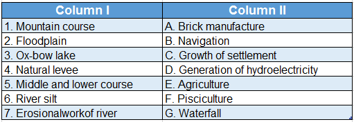
WBBSE Chapter 9 Continent Of Asia Topic A Revolution Of The Earth Match The Columns

Question 1.WBBSE Solutions For Class 7 Geography Chapter 9 Topic A Revolution Of The Earth Macth the columns

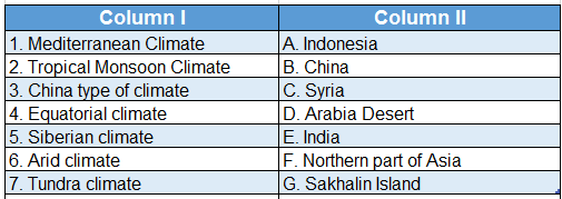
Answer: 1. C, 2. E, 3. B, 4. A, 5. G. 6. D, 7. F

Question 2.WBBSE Solutions For Class 7 Geography Chapter 9 Topic A Revolution Of The Earth Macth the columns.

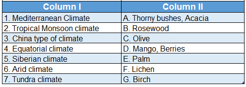
Answer: 1. C, 2. D, 3. E, 4. B, 5. G. 6. A, 7. F


WBBSE Solutions For Class 7 Geography Chapter 8 Soil Pollution

WBBSE Chapter 8 Soil Pollution Long Question And Answers

Question 1. Discuss the sources or causes of soil pollution.
Answer:

Sources or causes of soil pollution:

Soil can become polluted because of natural as well as man-made reasons. Natural causes of soil pollution are heavy rainfall, landslide, strong wind movement, etc. But soil pollution is mainly caused due to indiscriminate activities of men.

The main sources of soil pollution are as follows-

1. Urbanisation:

The constant rise in population has increased the demand for dwelling places. So forests are being cleared to provide more land for dwelling and agriculture. As a result, the soil is getting eroded as well as polluted.

2. Agriculture:

  • The demand for food increases with the rise in population. So, the use of chemical fertilizers and pesticides also increases to produce more crops on the same plot of land.
  • This leads to the death of several creatures like earthworms and other insects which live in the soil. This, in turn, lowers the fertility of soil and causes soil pollution.

Read And Learn Also WBBSE Solutions For Class 7 Geography

3. Industrial pollution:

  • Every year, about 16000 kg of hard disposable industrial wastes accumulate on the ground.
  • Every year about 2×10⁹ kg of fly ash is ejected from leather, dye, plastic and paper industries; oil refineries; metal extraction plants and thermal power plants and this lowers the soil fertility.
  • Also, the smoke and poisonous gases (SO2, NO2) coming out from factories cause acid rain which contaminates the soil.

WBBSE Solutions For Class 7 Geography Chapter 8 Soil Pollution Causes of soil pollution

  • Domestic wastes: Bacteria, virus,es and other microbes breed on the garbage heaps disposed from houses, hospitals, markets, towns, and cities. The poisonous chemicals in these heaps pollute the Earth.
  • Atomic pollution: A vital cause of soil pollution is the existence of atomic power stations, atomic research centers, hospitals, and nursing homes using radioactive materials and radioactive wastes.
  • Medical wastes: An important cause of soil pollution is the disposal of medical waste without proper segregation from various hospitals and medical centers.
  • Transport: Vehicles usually emit smoke containing CO2, SO2, etc. which mixes with rainwater and falls on the ground as acid rain. This rainwater mixes with soil and causes soil pollution.

WBBSE Solutions For Class 7 Geography Chapter 8 Soil Pollution

Question 2. Describe the methods used to control soil pollution.
Answer:

Methods used to control soil pollution:

The methods used to control soil pollution are-

  • Increased use of organic fertilizer: Increase in the use of organic fertilizers instead of chemical fertilizers so that the soil health remains unaffected.
  • Less use of plastic: Wherever plastic is discarded as a waste product it clogs soil pores. It causes soil pollution. Thus the use of plastic products should be lessened. We can use paper and jute bags instead of plastic.
  • Specific ground for waste disposal: Wastes should be disposed off in specific dumping grounds or vats and not thrown here and there.
  • Proper method of waste disposal: The proper method should be undertaken for disposal of solid hazardous wastes to prevent deterioration of soil health and the environment being affected at any and every place.
  • Recycle: Recycling of soil pollutants should be encouraged to lessen their harmful impacts.
  •  Implementation of strict laws: Strict laws should be implemented for waste disposal to control soil pollution.
  • Soil testing: Regular soil tests should be done as a method to control soil pollution.
  • Increase awareness: The people should be made aware about the ways to prevent soil pollution.
WBBSE Class 7 Geography Notes WBBSE Solutions For Class 7 History
WBBSE Solutions For Class 7 Geography WBBSE Class 7 History Multiple Choice Questions
WBBSE Class 7 Geography Multiple Choice Questions WBBSE Solutions For Class 7 Maths


Question 3. Write a note on the effects of soil pollution on human life.
Answer:

Effects of soil pollution on human life:

Soil pollution brings about the following effects on human life-

  1. Polluted soil is the breeding ground of various microbes that cause diseases in the human body such as cholera, amoebiasis, typhoid, and paratyphoid.
  2. Inorganic pollutants like mercury cause a variety of diseases like mental illness, loss of eyesight, etc.
  3. Due to the effect of cadmium, different diseases occur in the human body like increased blood pressure.
  4. Under the effect of lead, different diseases are observed in the human body like anemia.
  5. DDT and other slowly degradable chemical substances which enter our food chain, pass from lower to higher nutrient levels. It accumulates within the organisms. This is called biomagnification.
  6. Under the effect of soil pollution, soil fertility decreases, which in turn lowers the productivity of the land thereby decreasing the income of the farmers.
  7. When the pesticide and fertiliser-contained soil drains into the nearby waterbodies it renders the water of the waterbody unfit for further human use.

Question 4. Observe soil pollution in your locality and write it down.

  1. Name of locality or village………….
  2. Is the garbage of your house disposed off at a certain place?
  3. Is that waste cleaned every day?
  4. Do you find any difference in colour of the soil around the factories and that near your house?
  5. Make a list of the causes of soil pollution in your area.

Answer:

Name of the student: Sk Arman Class: VII

School: Guptipara High School.

WBBSE Solutions For Class 7 Geography Chapter 8 Soil Pollution Soil pollution in locality

Question 5. How do household and municipal solid wastes cause soil pollution?
Answer:

Household and municipal solid wastes cause soil pollution:

  • Solid wastes of households example, broken pieces of plastic, torn packets, paper, clothes, batteries, broken glass, food and kitchen wastes like vegetable peel, and fruit peel, and municipal wastes like excreta, and medical wastes are collected by the municipality within an area.
  • These waste materials are segregated and then sent for reprocessing. Most of the domestic wastes are directly transported to landfill sites for disposal without proper segregation into organic, reusable, and recyclable wastes.
  • This is one of the main causes of soil pollution.

Example-The Dhapa dumping ground just outside Kolkata has become polluted. As a result, fruits and vegetables grown in polluted soil transmit a variety of diseases in humans.

These diseases have maximum manifestation at the producer level and this is called ‘biomagnification’.

WBBSE Solutions For Class 7 Geography Chapter 8 Soil Pollution Biomagnification

Question 6. How do plastics aggravate the problem of soil pollution?
Answer:

Plastics aggravate the problem of soil pollution:

At present different types of plastic are used in various parts of the world. These can be biodegradable as well as non-biodegradable. Wherever plastic is discarded as a waste product, it clogs soil pores, drains, pipes, and ditches.

The various ways in which plastic causes soil pollution are-

  1. Clogging of soil pores by plastic wastes and wrappers results in the loss of soil fertility making the farmland unsuitable for cultivation.
  2. Plastic wastes accumulating on the wetlands make them overflow with water.
  3. The plastic-forming compounds kill different microorganisms present in the soil and harm man and other living beings.

WBBSE Solutions For Class 7 Geography Chapter 8 Soil Pollution Plastic pollution

Question 7. Explain how soil pollution is caused due to use of pesticides.
Answer:

Excessive use of pesticides causes soil pollution in farmlands in the following ways-

  1. Pesticides and herbicides are a type of poison which are not decomposed by bacteria. As a result, they accumulate in the soil causing soil pollution.
  2. The poisonous chemicals present in pesticides mix with the soil when sprayed on agricultural fields. The agricultural runoff flows into the waterbodies, causing further water pollution.
  3. Excessive use of pesticides also kills other soil organisms.
  4. The harmful effects of pesticides are also observed in human beings. Human beings ingest these toxic elements through the consumption of contaminated vegetables. Accumulation of these poisonous components in the body weakens the nervous system. As a result, lung diseases and stomach infections are common. It can even lead to cancer.

WBBSE Solutions For Class 7 Geography Chapter 8 Soil Pollution Pesticides causing soil pollution

Question 8. How does inorganic manure cause soil pollution?
Answer:

Inorganic manure cause soil pollution:

if the inorganic manure or fertilizers are used in greater quantity it brings about soil pollution in the following ways-

  1. If inorganic manure or fertilizers containing nitrogen is used excessively in agricultural grounds, it gets converted to poisonous nitrogen dioxide in the presence of sunlight, which in turn causes soil pollution.
  2. Though this chemical increases soil productivity in the short run, in the long run, this chemical clogs the soil pores lowering the aeration and water-holding capacity of the soil.
  3. Thus soil productivity decreases in the long run.
  4. Excessive use of phosphates to increase soil productivity also causes soil pollution as high levels of phosphate dissolved in the soil harm plant growth.

Question 9. What are the different types of soil pollutants?
Answer:

Different types of soil pollutants:

The substances which bring about soil pollution are called soil pollutants. The different types of pollutants and their origin are listed below-

WBBSE Solutions For Class 7 Geography Chapter 8 Soil Pollution Different types of pollutant and their origin

Question 10. Fill up the knowledge hive with information about the Chernobyl disaster.

WBBSE Solutions For Class 7 Geography Chapter 8 Soil Pollution Chernobyl Disaster

Answers:

1. A nuclear reactor exploded at Chernobyl in Ukraine at 1.30 am on 26 April 1986.
2. In this explosion radioactive materials. scattered over a region of about 3000 sq km.
3. In this explosion 31 persons had died and more than a million were severely affected.
4. The land on the periphery of the explosion zone became unsuitable for agriculture.
5. Farm animals as well as human beings gave birth to deformed progeny due to the effect of radioactivity.

Question 11.


WBBSE Solutions For Class 7 Geography Chapter 8 Soil Pollution Crossword

Down:

1. Soil pollutant
3. A ferroalloy

Across:

2. A vegetation cover that controls soil erosion and promotes soil fertility
4. Chemical sprayed on farmlands to kill pests.
5. The gas which leaked in the Bhopal Disaster

Answers:

Down: 1. PLASTIC, 3. ARSENIC
Across: 2. GRASSLAND 4. PESTICIDE 5. MIC

Question 12.


WBBSE Solutions For Class 7 Geography Chapter 8 Soil Pollution Crossword.

Down:

1. An inorganic pollutant.
2. Organic matter whose presence turns the color of the soil black
3. A gas emitted through the decomposition of soil organisms.

Across:

4. A heavy metal
5. A chemical fertilizer

Answers:

Down: 1. PHOSPHATE, 2. HUMUS, 3. METHANE
Across: 4. CADMIUM, 5. UREA

WBBSE Chapter 8 Soil Pollution Short Question And Answers

Question 1. How does industrialization cause soil pollution?
Answer:

Industrialization cause soil pollution:

  • Industrial centers are the major sources of chemicals that cause soil pollution. The wastewater that is discharged from various industrial activities contains a lot of chemicals, radioactive materials, metallic wastes, and many other insoluble materials.
  • Besides, different gaseous and non-gaseous wastes are let out from factories and mixed with the soil causing soil pollution.

For example- Fly ash from thermal power stations mixes with the soil reducing its fertility.

Question 2. Describe how inorganic wastes cause soil pollution.
Answer:

Inorganic wastes cause soil pollution:

  • Poisonous metals generated from different metal-based industries example, lead, copper, mercury, nickel, cadmium, and waste products from towns and cities example, plastic, gas, storage battery, and chemical fertilizers usually accumulate in the soil.
  • The organisms present in the soil absorb these toxic compounds and degenerate the soil quality. This is known as pollution by inorganic wastes.

Question 3. How does urbanization cause soil pollution?
Answer:

Urbanization cause soil pollution:

High rate of population growth has increased the pace of urbanization.

  • It has resulted in an increase in the requirement of land for dwelling, agricultural activities, industrial activities, construction areas, etc.
  • These have led to an increase in the following factors-construction of brick kilns, landfill, and illegal dumping, throwing of domestic garbage anywhere, improper disposal of municipal and industrial wastes.
  • As a result of these soil is getting eroded as well as polluted.

Question 4. How do agricultural activities cause soil pollution?

Agricultural activitAnswer:ies cause soil pollution in the following ways-

  •  Use of pesticides: To increase the productivity of crops, spraying of pesticides is very common. This kills the beneficial microorganisms and other organisms present in the soil. As a result, the soil loses its productivity.
  • Use of chemical fertilizers: To increase agricultural productivity, chemical fertilizers are sprayed on fields. This alters the organic composition of the soil, increasing its salt content. As a result, the soil becomes unproductive.
  • Excessive ploughing: Excessive ploughing on agricultural fields erodes the top layer of the soil, resulting in the removal of the nutrients contained in it

Question 5. Write a short note on the effects of soil pollution.
Answer:

The effects of soil pollution are-

  1. Loss of fertility and productivity of the soil.
  2. Changes in the physical and chemical characteristics of the soil.
  3. Lowering of the protein content of various crops.
  4. Affected plant growth and animal health.
  5. Affected crop cultivation and human health.
  6. Groundwater pollution.
  7. Imbalance in the natural ecosystem.

Question 6. What is the impact of acid rain on the soil?
Answer:

Impact of acid rain on the soil:

Acid rain falling on the Earth’s surface adversely affects the soil. The major effects of acid rainwater mixed with the soil are as follows:

  1. The soil becomes acidic.
  2. The flora cannot perform photosynthesis, leading to the growth of distorted branches and stems.
  3. This affects the normal growth and development of plants.
  4. The soil loses its fertility making it unsuitable for cultivation.
  5. Death of the microorganisms that are present in the soil is one of the harmful impacts of acid rain.

Question 7. Write a brief note on Bhopal Gas Tragedy.
Answer:

Bhopal Gas Tragedy:

  • The Bhopal Gas Tragedy was a toxic gas leak incident in India that occurred on the night of 2-3 December 1984 from the pesticide plant of Union Carbide India Limited in Bhopal, Madhya Pradesh.
  • The local people were exposed to about 36 tonnes of toxic methyl isocyanate or MIC gas and other chemicals. This gas affects the human lungs and burns the cornea of the eyes.
  • The Bhopal Disaster brought about the death of around 10,000 people (unofficial count) approximately and disabled or injured another 2 lakh people.

Question 8. Write a short note on Chornobyl Disaster.
Answer:

Chornobyl Disaster:

  • The Chornobyl Disaster was a catastrophic nuclear accident that occurred on 26 April 1986 at the Chornobyl Nuclear Power Plant in Ukraine.
  • An explosion and fire released a large quantity of radioactive particles into the atmosphere, which spread over a wide area. About 1 lakh 35 thousand people were evacuated as a result of this disaster.
  • According to scientists, the impact of this disaster will be felt for another 100 years.

Question 9. What are the things one should do to avoid soil pollution in villages?
Answer:

‘Things to do’ in villages to avoid soil pollution are as follows-

  1. Farmers should be explained why excessive use of chemical fertilizers in farmlands is not advisable and their harmful effects on human health.
  2. The farmers should be made aware about the advantages of organic farming.
  3. The farmers should be told about the negative effects of pesticides.
  4. The farmers should be explained the advantages of controlled growth of organisms in comparison to the use of pesticides.
  5. Farmers should be made aware about the high water retention capacity. This soil is ideal negative effects of mono-cropping.
  6. Information and advice should be given to the farmers about the general improvement of their farm produce.
  7. The people should be made aware of the inter-relationship between the environment and farming.

Question 10. What is the importance of soil?
Answer:

Importance of soil:

The importance of soil is limitless. A few of them are as follows-

  1. Soil provides water, minerals, and nutrients which help organisms to survive.
  2. Plants grow in soil.
  3. The soil acts as the safest habitat for bacteria, fungi, algae, rats, worms, etc.
  4. A variety of crops grow in a variety of soil. For example, cotton grows in black regur soil, wheat grows in chernozem soil.
  5. The brick kilns and clay industry are highly dependent on soil.

Question 11. Huge amounts of paddy, jute, and vegetables are grown in the silt soil on the banks of the Ganga. But less amount of crops grows in the coarse soil of Purulia. Why?
Answer:

The alluvial soil formed by silt deposited by River Ganga is fine-grained, fertile, and has for crop cultivation because the movement of air within the soil particles is good.

  • On the other hand, the soil in Purulia is coarse, infertile, and full of pebbles.
  • It contains very less organic matter and has a low water-retention capacity.
  • Therefore, crops do not grow in abundance in the soil of Purulia.

Question 12. Beautiful flowers bloom every day in the plants of your flower pots or garden. What may happen to the plant if filthy oil is poured into the pot?
Answer:

Beautiful flowers bloom every day in the plants of your flower pots or garden.

If filthy oil is poured into the flowerpots, it will degrade the soil quality. The plant will not be able to obtain the necessary nutrients from the soil and after a few days it will die, because-

  1. Plant roots will not be able to take in water from the soil.
  2. The level of nutrients present in the soil will decrease.
  3. The movement of air within the soil will decrease.

Question 13. What do you mean by soil pollution?
Answer:

Soil pollution:

  • Any process that degrades the quality of soil and reduces its productivity and utility is called soil pollution.
  • Harmful chemicals from agricultural run-offs due to overuse of chemical fertilizers and pesticides, weedicides, plastic, domestic wastes, industrial wastes, biodegradable and non-biodegradable substances, and radioactive waste products mix with the soil.
  • Thereby altering its properties or characteristics and nutrient content.

Question 14. How do the microorganisms cause soil pollution?
Answer:

Microorganisms cause soil pollution:

  • Waste products of households, markets, and hospitals are usually not disposed of properly.
  • This garbage acts as the breeding ground of different viruses and bacteria which affect the soil quality and the organisms present in it. The soil becomes unproductive.

Question 15. Write how radioactive pollutants cause soil pollution.
Answer:

Radioactive pollutants cause soil pollution:

  • Radiation from nuclear reactors, medical imaging, and scientific research processes emit radioactive substances or particles.
  • These emitted particles mix with the soil causing soil pollution. The main radioactive pollutants are- Carbon 13, Uranium-235, Radium-226, etc.

Question 16. How is soil pollution caused by soil erosion?
Answer:

Soil pollution caused by soil erosion:

  • Removal of the fertile topmost layer of the soil which contains organic matter or humus due to the action of natural agents like rain, running water, wind, and glacier is called soil erosion.
  • As the uppermost layer is removed the soil loses its fertility and becomes unsuitable for plant growth. Thus, soil erosion is a natural factor causing soil pollution.
  • Among the pesticides used in agricultural fields, the chemicals which cause maximum soil pollution are Dichloro Diphenyl Trichloroethane (DDT), Benzene Hexachloride (BHC), Pyrethrin, Malathion, and compounds containing carbonate.
  • The main chemical fertilizers causing soil pollution are urea, phosphate, and sulfate compounds.

Question 17. What are the diseases caused in humans as a result of soil pollution?
Answer:

Many diseases and their symptoms are observed in humans as a result of soil pollution.

These are as follows-

WBBSE Solutions For Class 7 Geography Chapter 8 Soil Pollution diseases caused in humans as a result of soil pollution

Question 18. Name the type of diseases which occur in human bodies due to the use of pesticides.
Answer:

  • Pesticides enter the human body through the consumption of fruits and vegetables.
  • The high amount of accumulated pesticides in the human body weakens the nervous system resulting in lung diseases and stomach infections and may often lead to cancer.

Question 19. What are the causes of the increase in the level of acidity of the soil?
Answer:

The causes of the increase in the acidity level of soil are as follows-

  • In forest areas, the dead leaves fall on the forest floor, get decomposed, and form humus. This humus releases humic acid which increases the acidity of the soil.
  • Presently eucalyptus trees have been planted in various forest areas to curb the effect of deforestation. The acidity level of the eucalyptus leaves is high. The leaves that fall on the forest floor mix with the soil turning it acidic.
  • Nowadays, nitrogen-based fertilizers are used in abundance on the farmlands. This increases the acidity of the soil.
  • Toxic wastes discharged from various industries are highly acidic in nature. These mix with the soil turning it acidic.

Question 20. How does the organic matter present in the soil cause soil pollution?
Answer:

The organic matter present in the soil cause soil pollution:

  • When inorganic pesticides, like DDT and Chlorodon mix with the soil, the organisms present in the soil absorb these substances into their bodies.
  • Gradually the poison released from the chemicals moves within the body of the organisms poisoning the organic matter of the soil. This is called soil pollution due to organic matter the soil.

Question 21. What are the causes for increased levels of salinity in the soil?
Answer:

The causes of the increase in the salinity level of the soil are-

  1. Intensive irrigation on farmlands increases soil salinity.
  2. Continuous irrigation on the same plot of land accumulates the soluble salts which then get stored in the soil increasing its salinity.

WBBSE Chapter 8 Soil Pollution Very Short Question And Answers

Question 1. Which term is used to denote the deterioration of soil quality?
Answer: Soil pollution.

Question 2. What are burnt ash from coal and coal particles emitted along with the smoke of factories and thermal power stations collectively called?
Answer: Fly ash.

Question 3. Name a non-degradable material which blocks the sewage drains of cities.
Answer: Plastic.

Question 4. Name one radioactive pollutant.
Answer: Uranium.

Question 5. Which type of rainfall increases soil acidity?
Answer: Acid rain.

Question 6. Which poisonous substance was responsible for Bhopal Gas Tragedy?
Answer: MIC gas (Methyl Isocyanate).

Question 7. Which disaster occurred in a nuclear power station in Ukraine in 1986?
Answer: Chornobyl disaster.

Question 8. Which type of farming does not cause soil pollution?
Answer: Organic farming.

Question 9. I am a process. My harmful effect degrades the quality of soil and reduces its productivity and utility. Who am I?
Answer: Soil pollution

Question 10. Cutting us down washes the soil during heavy rainfall. Who are we?
Answer: Plants and trees

Question 11. Our application increases crop productivity but excessive use causes soil pollution. Who are we?
Answer: Chemical fertilizers

Question 12. My application kills the disease-causing microbes and both useful and harmful insects present in the soil. Who am I?
Answer: Pesticide

Question 13. I am emitted from thermal power stations and on settling down on the soil, I cause soil pollution. Who am I?
Answer: Fly ash

Question 14. I mix with rainwater, thereby increasing the soil acidity. I kill or harm organisms present in soil. Who am I?
Answer: Acid rain

Question 15. We do not decompose easily, and restrict the entry of water by clogging the soil pores. Who are we?
Answer: Plastic, polythene

WBBSE Chapter 8 Soil Pollution Fill In The Blanks

Question 1. Particles of _______ and _______ mix with rainwater causing soil pollution.
Answer: Radium, iodine

Question 2. _______ emitted from thermal power plants mixes with the soil, degrading its fertility.
Answer: Fly ash

Question 3. The excreta of humans and animals are the main source of _______ soil pollution.
Answer: Organic

Question 4. The sewage system is badly affected by improper disposal of _______.
Answer: Plastic

Question 5. An important inorganic soil pollutant is _______.
Answer: Plastic

Question 6. An example of a living soil pollutant is _______.
Answer: Protozoa

Question 7. Bacteria is an example of _______ soil pollutant.
Answer: Living

Question 8. _______ is a type of heavy metal soil pollutant.
Answer: Cadmium

Question 9. Plastic is an example of _______ soil pollutant.
Answer: Inorganic

Question 10. An example of medical waste is _______.
Answer: X-ray plate

Question 11. High amounts of accumulated pesticides in human bodies cause diseases in _______ and _______.
Answer: Lungs, stomach

Question 12. Soils which have low organic matter are _______.
Answer: Infertile

Question 13. The gas responsible for the Bhopal Gas Tragedy is _______.
Answer: MIC

Question 14. The Chornobyl Disaster took place in _______.
Answer: Ukraine

Question 15. _______ Farming reduces agricultural soil
Answer: Organic

WBBSE Chapter 8 Soil Pollution True Or False

Question 1. Acid rain does not cause soil pollution.
Answer: False

Question 2. Dead remains of plants and animals present in the soil do not form humus.
Answer: False

Question 3. Plastic is an inorganic compound which cannot be decomposed.
Answer: True

Question 4. Industrial wastes are not found in the soil of the Asansol-Durgapur industrial belt.
Answer: False

Question 5. The major cause of soil pollution in urban areas is acid rain.
Answer: True

Question 6. The waste products of hospitals cause soil pollution.
Answer: True

Question 7. Plastic and polythene substances do not cause soil pollution when in contact with soil.
Answer: False

Question 8. The garbage disposal site in Kolkata is Dhapa dumping ground.
Answer: True

Question 9. To control soil pollution, decomposed substances should be buried under the soil.
Answer: True

Question 10. Bhopal Gas Tragedy happened in 1984.
Answer: True

WBBSE Chapter 8 Soil Pollution Find The Odd One Outs

Question 1. Increasing population Deforestation: Contamination of waterbodies: Landslide
Answer: Contamination of waterbodies (not related to soil erosion)

Question 2. Chernobyl : Fukushima: Hiroshima : Bhopal
Answer: Bhopal (not related to radioactive pollution)

Question 3. Posts: Polythene : Plastic: Artificial rubber
Answer: Pests (not related to soil pollution)

Question 4. Thermal power station: Brick-kiln ash: Radioactive wastes: Landslide
Answer: Landslides (not a man-made cause of soil pollution)

WBBSE Chapter 8 Soil Pollution Correct The Following

Question 1. Water becomes polluted if the same crop is planted again and again.
Answer: Soil

Question 2. Air gets polluted if the soil is dug to make bricks for the kiln.
Answer: Soil

Question 3. 90% of the world’s population live on 90% of the landmass on the Earth.
Answer: 10%

Question 4. Only part of the Earth is water.
Answer: Land

WBBSE Chapter 8 Soil Pollution Scrambled Words

1. SANIBAONURTI
2. ERBAIACT
3. TISCIPEDE
4. ERNOBCHYL
5. OACDIVIRATITY

Answers:

1. URBANISATION
2. BACTERIA
3. PESTICIDE
4. CHERNOBYL
5. RADIOACTIVITY

WBBSE Chapter 8 Soil Pollution Match The Columns

Question 1.WBBSE Solutions For Class 7 Geography Chapter 8 Soil Pollution Match the columns

Answer: 1. D, 2. A, 3. B, 4. E, 5. C

Question 2.WBBSE Solutions For Class 7 Geography Chapter 8 Soil Pollution Match the columns.

Answer: 1. E, 2. C, 3. D, 4. B, 5. F, 6. A

Question 3. WBBSE Solutions For Class 7 Geography Chapter 8 Soil Pollution Match the columns,.

Answer: 1. D, 2. E, 3. A, 4. F, 5. C, 6. B

WBBSE Solutions For Class 7 Geography Chapter 7 Water Pollution

WBBSE Chapter 7 Water Pollution Long Question And Answers

Question 1. Discuss the causes of water pollution.
Answer:

Causes of water pollution:

Water can be polluted in various ways-

1. Pollution due to industrial wastes:

Water pollution is caused by industrial wastes disposed from petrochemical, plastic, fuel industries, and oil refineries (like copper, lead, chromium, calcium, zinc, and other metals, organic and inorganic compounds. of sulfur, phosphorus, and chlorine).

2. Pollution due to domestic wastes:

Vegetable peels, leftover food, detergent, soap, human wastes, and insecticides enter the rivers and other sources of water through the house drains. Again organic and inorganic wastes from markets, clinics, and hospitals also pollute water.

Read And Learn Also WBBSE Solutions For Class 7 Geography

3. Pollution from agriculture:

The chemical fertilizers and pesticides used in agriculture and chemical substances like nitrate, phosphate, and potash produced by weeds pollute water.

The nitrates present in fertilizers hamper blood circulation in children’s brains and are also a known cause of cancer.

4. Pollution from mineral oil:

Tanker accidents in the sea, bursting of conducting pipes, and wastes produced by the combustion of engine oil in ships, steamers, and mechanized boats pollute the river and seawater.

5. Thermal pollution in water:

A lot of water is required for cooling the machine parts in atomic power plants, thermal power plants, and different industries. When this heated water falls in rivers or seas and on the ground it causes harmful ecological changes in water and endangers the existence of aquatic creatures.

Apart from this, water also gets polluted due to arsenic pollution and air pollution.

WBBSE Solutions For Class 7 Geography Chapter 7 Water Pollution

Question 2. Write down the causes of pollution in the Ganga.
Answer:

The causes of pollution in the Ganga:

Polluted water from different sources mixes with the water of the river Ganga. The causes of pollution in river Ganga are-

1. Discharge of urban solid and liquid waste:

Often solid and liquid waste materials are discharged in Ganga from the cities located near the bank of river Ganga. These huge amounts of waste substances disposed from the cities located on the banks of river Ganga pollute the water.

2. Disposal of industrial waste:

The unrefined waste substances produced by the numerous industries which are situated on both sides of the banks of river Ganga are disposed in the river water making it unsuitable for drinking and for the survival of marine animals.

3. Washed away the water of fertilizers and pesticides:

Chemical fertilizers and pesticides used in the agricultural lands on the bank of river Ganga are washed away by rainwater to the river making the water polluted.

4. Pollution caused by shipping:

The large vessels, ships, and steamers that are used as modes of transport in river Ganga, sometimes throw burnt oil, grease, etc. into the water of Ganga which mixes with it and makes the river water polluted.

5. Other causes:

Idols, flowers used in pujas, household wastes, etc. are disposed of in Ganga. This is gradually increasing the pollution in river Ganga.

WBBSE Class 7 Geography Notes WBBSE Solutions For Class 7 History
WBBSE Solutions For Class 7 Geography WBBSE Class 7 History Multiple Choice Questions
WBBSE Class 7 Geography Multiple Choice Questions WBBSE Solutions For Class 7 Maths


Question 3.  Discuss the effects of water pollution.
Answer:

Effects of water pollution:

The effects of water pollution are as follows-

1. Effect on human health:

  1. Arsenic pollution can cause cancer of the lungs, liver, kidney, bladder, and skin.
  2. Black patches develop on the palms and soles as a result of arsenic reactions. This is called Blackfoot disease.
  3. Diseases like viral hepatitis, polio, cholera, and dysentery are caused by water pollution.
  4. IQ of children decreases due to lead pollution.

2. Effect on agriculture:

If contaminated water is used on agricultural lands, then the beneficial bacteria, virus, and other micro-organisms are killed and this affects the crops adversely. Again the presence of various heavy metals can also be detected in the produced crops.

3. Effect on the sea:

  • If the seawater gets polluted then it greatly harms the aquatic plants and animals as well as the entire ecosystem. For instance, the ecosystem around the Minamata Gulf was greatly harmed by mercury pollution.
  • Some compounds also destroy the taste and color of fish.

4. Effect on birds:

If polluted water seeps into the sea then it becomes quite harmful for fish and the birds dependent on those fish. For instance, more than a million birds were killed during the Gulf War.

Question 4. What are the essential measures of controlling water pollution?
Answer:

Essential measures of controlling water pollution:

The following measures are to be adopted to control and prevent the harmful effect of water pollution-

  1. Industrial effluents should be properly treated and neutralized in a scientific way before being discharged in the river.
  2. Domestic waste and sewage should be discharged into waterbodies only after treatment.
  3. Oil tankers should take careful measures to avoid oil spills.
  4. Waterbodies should be cleared of water hyacinths, algae, mosses, etc. Weeds and other unwanted plants must be removed from the banks before every rainy season.
  5. The waterbodies used for drinking purposes should not be used for washing clothes, bathing of humans and animals, etc.
  6. The use of chemical fertilizers and pesticides in agricultural fields should be reduced.
  7. Awareness regarding the harmful effects of polluted water should be spread among the common people.

Understanding Water Pollution

Question 5. What can be done to conserve water and control water pollution?
Answer:

Ways to conserve water and control water pollution:

Water is very essential for living organisms. So to conserve water and control water pollution, the society needs to play a significant role. There are many ways to conserve water and control water pollution-

1. Avoiding misuse of water:

If not required the water tap should be closed. In this way pure water will not be wasted and water pollution will also decrease.

2. Use of harmless soap and shampoo:

Less alkaline soap, shampoo, detergent, etc. should be used which will not harm the environment and control the pollution of water.

3. Disposal of waste in a particular place:

House waste, liquid waste, etc. should be disposed off in such a place so that it would not mix with pure water.

4. Planting trees:

Vegetable plants and plants bearing fruits and flowers should be planted in gardens, banks of ponds, around wells, and tube wells. In this way polluted water can be treated and soil erosion can be prevented.

5. Reusing water:

Water should be recycled and reused in many ways.

6. Increasing social awareness:

People can be made aware of water conservation and control of water pollution through seminars, posters, essay-writing competitions, etc.

Apart from this, in low cost, knowledge can be imparted to people about water purification and different ways of water conservation.

Question 6. What are the major water reserves on Earth?
Answer:

The major water reserves on Earth:

Three-fourths of the Earth’s surface is covered with water. Out of the total water on the Earth’s surface, 97% is ocean water of the seven oceans on Earth. The Pacific Ocean is the largest and has the maximum volume of water.

Of the three parts of freshwater, two parts are stored as glaciers and ice caps; the remaining one part of freshwater includes the water in rivers, ponds, lakes, and groundwater.WBBSE Solutions For Class 7 Geography Chapter 7 Water Pollution The major water reserves on earth

Question 7. What are the sources or causes of water pollution in villages?
Answer:

The causes of water pollution in villages are-

  1. In the villages, humans and animals like cattle together bathe in ponds and other smaller waterbodies. Again, in that same water, utensils, and clothes are also washed. This makes the water very polluted.
  2. Many villagers excrete water very polluted. on the banks of the water bodies thus leading to more water pollution.
  3. Nowadays, chemical fertilizers, insecticides, and pesticides are used extensively to raise crops and improve soil productivity of farmlands in villages. These are washed away by rainwater to the waterbodies, thus causing water pollution.

Question 8. What are the sources or causes of water pollution in urban areas?
Answer:

The causes of water pollution in urban areas are-

  1. There are many industries in the urban areas. Industrial activities create a wide variety of waste products which are discharged into the waterbodies, causing contamination of water.
  2. In urban areas, soaps and detergents are very widely used. These substances get discharged in the river bodies through the sewage system and cause water pollution.
  3. Household waste, domestic wastewater, municipal waste or sewage are also carried to the river through drains and this, pollutes the rivers.

WBBSE Solutions For Class 7 Geography Chapter 7 Water Pollution Causes of water pollution in urban and rural areas

Question 9. How do heavy metals pollute water?
Answer:

Heavy metals pollute water:

  • Runoff from mines with high concentrations of chemicals, by-products from smelting plants, and lead emissions from vehicles cause water pollution.
  • These poisonous metals enter the food chain and thus are found in increasing proportion in human beings. An increased proportion of these poisonous metals in organisms can even cause death.
  • Some of the heavy metals causing a threat to human health are lead, mercury, cadmium, zinc, tin, manganese, cobalt, arsenic, and so on.

Question 10. How does domestic waste cause water pollution?
Answer:

Domestic wastewater contains paper, polybags, plastic articles, cloth, soap, excreta, vegetable waste, etc. Polluted water from restaurants mixes with the water of ponds, water- bodies, rivers, and so on, causing water pollution.

This may cause water pollution in three ways-

  1. Eutrophication,
  2. Biological oxygen demand and
  3. Inorganic non-biodegradable waste.

Question 11. How do pesticides cause water pollution?
Answer:

  • Excessive use of pesticides, insecticides, and weedicides is common in farms practicing mixed farming, high-yielding paddy cultivation, and farming using modern techniques.
  • The run-off from these chemically-treated fields flows into nearby waterbodies thereby causing water pollution.
  • This type of water pollution is called water pollution due to the use of pesticides.
  • The main pesticides used are D.D.T. gamaxene, endrin, folidol, etc.

Question 12. How do radioactive wastes cause water pollution?
Answer:

  • Radioactive elements like uranium, thorium, radium, etc. spontaneously disintegrate in a short period, thus emitting electromagnetic radiations like alpha and beta particles and gamma rays, which are very harmful to living organisms.
  • This is called radioactive pollution. Radioactive elements are used in various nuclear reactors and scientific research. The radioactive wastes are dumped into rivers, seas, and oceans after use which causes water pollution.

Question 13. What do you mean by thermal pollution of water?
Answer:

There are two main sources of thermal pollution.

They are-

  1. Machineries of different industries are immersed in water to cool which in turn makes the water warm.
  2. Warm water comes out from thermal power plants and atomic power stations.

This warm water is discharged into rivers and other waterbodies causing thermal pollution of water. Various aquatic organisms like fish die and aquatic flora is destroyed.

Question 14. What is arsenic pollution?
Answer:

Arsenic pollution:

  • Unlimited extraction of groundwater from wells and tubewells results in void space within the layers.
  • Air enters these void spaces and reacts with the arsenic element of the bedrock forming poisonous arsenic compounds.
  • This dissolves in the groundwater causing a kind of water pollution called arsenic pollution.
  • A high level of arsenic contamination has been found in the districts of West Bengal located to the east of River Ganga.
  • According to the Bureau of Indian Standards, the permissible level of arsenic in drinking water is 0.01 mg/l.

Question 15. What causes arsenic pollution?
Answer:

The causes of arsenic pollution are-

  1. Overuse of groundwater.
  2. Excessive use of insecticide, pesticide, fungicide, etc.
  3. Use of chemical fertilizers rich in ammonia, sulfates, and phosphates in high amounts.
  4. Excessive use of fossil fuels.
  5. Arsenic pollution may also occur while mining minerals like gold, copper, lead, etc., and in paints, soap, batteries, and medicine manufacturing industries.

Question 16. Explain fluoride pollution.
Answer:

Fluoride pollution:

Fluoride pollution is the pollution which is characterized by high levels of fluoride in water fluoride in each liter of water is considered as or air.

  • Water containing more than 1mg of polluted water.
  • Excessive intake of fluoride by humans for a long time causes a medical condition called fluorosis. It damages bones and teeth, causes skin irritation, affects the eyes, and lungs, and sometimes can damage the heart in humans.
  • Excessive fluoride in the body can cause calcium deficiency in the body.

Question 17. What are the harmful effects of water pollution?
Answer:

Human beings as well as aquatic flora and fauna and soil are affected by water pollution in various ways such as-

  1. Most of waterborne diseases like Typhoid, Cholera, Jaundice (Hepatitis), Amoebiasis, and Dysentery may spread through contaminated water.
  2. Water contaminated with copper, mercury, sulfur extracts may cause various skin diseases in humans.
  3. Water pollution removes various beneficial bacteria and other micro-organisms from the soil, thus lowering the fertility of the soil.
  4. Toxic sea water depletes the population of both aquatic plants and animals, thus decreasing the population of fish as well.

WBBSE Solutions For Class 7 Geography Chapter 7 Water Pollution Harmful effects of water pollution

Question 18. What are the effects of water pollution caused due to use of pesticides?
Answer:

The effects of water pollution caused due to use of pesticides:

Water pollution due to the use of pesticides has the following harmful effects on humans

  1. Though harmful pests are killed by the use of pesticides, the indiscriminate use of pesticides leads to the growth of various other viruses and bacteria.
  2. pH balance of water changes. Drinking water with a pH balance of less than 4 may be fatal.
  3. Strong pesticides kill the aquatic flora and fauna thus disturbing the balance of the aquatic ecosystem.

Question 19. What is Minamata disease?
Answer:

Minamata disease:

Japan’s Chisso Corporation’s chemical factory released methylmercury in the industrial wastewater from 1932 to 1968 which flowed into the Minamata Bay.

This highly toxic chemical bio-accumulated in the shellfish and fish, which when eaten by the local population caused mercury poisoning. This came to be known as the Minamata disease. The symptoms of this disease are-

  1. Numbness of hands and legs
  2. Muscle weakness
  3. Insanity
  4. Paralysis.

About 2,265- people were affected by this disease and among them, about 1,784 people died.

Question 20. What happened due to oil spills in the Persian Gulf during the Gulf War of 1991?
Answer:

During the Gulf War of 1991, many oil wells of Iran and Kuwait were set on fire. Besides, a huge quantity of petroleum got mixed in the waters of the Persian Gulf. As a consequence, the ocean water was polluted and many marine organisms died.

Question 21. What are the different diseases caused due to heavy metal contamination of drinking water?
Answer:

The different diseases caused due to heavy metal contamination of drinking water are-

  1. ‘Blackfoot’ disease as a result of arsenic pollution.
  2. ‘Fluorosis’ disease as a result of fluoride pollution.
  3. ‘Itai-itai’ disease as a result of cadmium pollution.
  4. ‘Minamata’ disease as a result of mercury pollution.

Question 22. What are the effects of arsenic pollution?
Answer:

Prolonged drinking of arsenic-contaminated water has the following effects-

  1. The skin becomes dull/pale.
  2. Black spots or patches are seen on the soles of the feet, palms of hands, lower abdomen, neck, shoulders, chest, and back. This is called Blackfoot disease.
  3. Difficulty in standing, walking, and carrying heavy things.
  4. Severe pain in the limbs i.e., hands and feet.
  5. Cancers of the bladder, kidney, and lung. Direct consumption of arsenic leads to nausea, vomiting, blood diarrhea, metallic taste in the mouth, extreme pain in the lower abdomen, and may also cause death.

Question 23. What is eutrophication?
Answer:

Eutrophication:

Surface run-off from agricultural fields contain inorganic compounds rich in nitrates, phosphates, and sulfates, which are carried to nearby ponds, lakes, rivers, etc.

As a result, the nutrient content of the water bodies increase, which promotes the excessive growth of phytoplanktons and algae. This phenomenon is called eutrophication. If this leads to the following-

  1. As the number of aquatic plants increases, the Biological Oxygen Demand and the demand of oxygen of the aquatic plants increase.
  2. The aquatic plants and animals ultimately die due to lack of oxygen.

Question 24. What are the effects of ocean pollution?
Answer:

The effects of ocean pollution are-

  1. Due to oil spills in the bays and gulfs, many marine animals die,
  2. Direct discharge from urban sewage and industrial waste in the form of toxic wastes causes marine pollution. For instance, after the construction of Haldia Petrochemicals in Haldia, the number of hilsa fish at the mouth of the Haldi River has greatly decreased.
  3. Surface run-off (containing pesticides, insecticides, fertilizers, etc.) from agricultural fields causes marine pollution. For instance, a large number of fish have died in the Vembanad lagoon of Kerala, Chilka Lake of Odisha, and Kolleru Lake of Andhra Pradesh due to runoff.

Question 25. How does eutrophication affect the aquatic ecosystem?
Answer:

The harmful effects of eutrophication on the aquatic ecosystem are because of their rapid population growth, the aquatic plants require more and more quantity of oxygen and cause depletion of dissolved oxygen, thereby threatening the survival of other forms of aquatic life.

Question 26. What are the different types of water-borne diseases?
Answer:

The different waterborne diseases caused by microbes are listed below-

WBBSE Solutions For Class 7 Geography Chapter 7 Water Pollution Different types of water borne diseases


Question 27. Write a short note on Cholera.
Answer:

Cholera:

Type: Cholera is a waterborne disease caused by bacteria.

Micro-organism: The bacteria causing cholera is called Vibrio cholera

Symptoms:

  1. Watery diarrhea and frequent vomiting.
  2. Dehydration, dry mouth, and persistent thirst.
  3. Hands and legs become weak.

Question 28. Write briefly about Amoebiasis.
Answer:

Amoebiasis:

Type: Amoebiasis is a waterborne disease caused by protozoa.

Micro-organism: The micro-organism causing Amoebiasis is Entamoeba histolytica.

Symptoms:

  1. In the first stage of amoebiasis indigestion, acidity, and stomach infection is noticed.
  2. Mucus with stool.
  3. Abdominal pain and blood in the stool.

Question 29. What is dysentery?
Answer:

Dysentery:

Type: Dysentery is a waterborne disease caused by bacteria.

Micro-organism: The bacteria causing dysentery is known as Shigella dysentery.

Symptoms:

  1. Abdominal pain, vomiting, stomach infection, etc.
  2. Fever.
  3. Severe watery diarrhea accompanied by blood and mucus in stool.

Question 30. Describe Hepatitis.
Answer:

Type: Hepatitis is a type of waterborne disease caused by a virus.

Micro-organism: This waterborne disease is caused by the Hepatitis virus.

Symptoms:

  1. Nausea and poor appetite.
  2. Abdominal pain at times.
  3. Deep yellow urine.
  4. The patient gradually becomes weak.

Question 31. Write a short note on typhoid.
Answer:

Type: Typhoid is a type of waterborne disease caused by bacteria.

Micro-organism: The name of the bacteria causing typhoid is Salmonella typhi.

Symptoms:

The symptoms of this disease are –

  1. Stomach infections, vomiting, and abdominal pain are common.
  2. High temperature ranging between 104°F to 105°F persists for a long time.
  3. Headache and general weakness is observed.

Question 32. What measures can be taken to control waterborne diseases?
Answer:

The following measures should be taken to control waterborne diseases-

  1. Clean, pure, and safe drinking water is to be used.
  2. Water from rivers, ponds, and wells should be used for drinking only after purification.
  3. Hands and face should be cleaned with soap every time before eating.
  4. Consumption of cut fruits, ice, juice, coloured water in small packets sold on the roadside should be stopped.
  5. Vaccines and immunizations for the different waterborne diseases will help control the spread of such diseases.

Question 33. What are the different processes of purifying drinking water?
Answer:

The various processes for purifying drinking water are-

  1. Boil water at 100°C for about 10 minutes before drinking.
  2. Adding an appropriate quantity of chlorine to kill micro-organisms in water.
  3. Water is passed through charcoal, fine sand, and pebbles successively to get it purified.
  4. If a thin plastic bottle filled with water is kept in the sun for 6-7 hours, then the same benefits of boiled water can be obtained.
  5. Growing of water hyacinths helps to control the contamination of water as it absorbs many heavy metals and carcinogenic compounds present in water.
  6. Adding small amounts of bleaching powder in water helps to kill the microbes in water.
  7. Adding potassium permanganate in water also helps to kill harmful microbes in water.

Question 34. In what ways can the water that is unsuitable for drinking be changed into drinking water?
Answer:

The different ways by which water unsuitable for drinking can be changed into drinking water are-

  1. By removing the color, smell, and taste of the water, if any.
  2. By lowering the excess alkalinity of water.
  3. By removing the dissolved iron and manganese salts.
  4. By controlling the level of fluoride in water.
  5. By desalinating the water, if required.
  6. By mixing chlorine in the water.

Question 35. What measures can you take to prevent water pollution?
Answer:

Essential measures of controlling water pollution:

The following measures are to be adopted to control and prevent the harmful effect of water pollution-

  1. Industrial effluents should be properly treated and neutralized in a scientific way before being discharged in the river.
  2. Domestic waste and sewage should be discharged into waterbodies only after treatment.
  3. Oil tankers should take careful measures to avoid oil spills.
  4. Waterbodies should be cleared of water hyacinths, algae, mosses, etc. Weeds and other unwanted plants must be removed from the banks before every rainy season.
  5. The waterbodies used for drinking purposes should not be used for washing clothes, bathing of humans and animals, etc.
  6. The use of chemical fertilizers and pesticides in agricultural fields should be reduced.
  7. Awareness regarding the harmful effects of polluted water should be spread among the common people.

Question 36. What measures should be adopted to control arsenic pollution?
Answer:

The measures to control arsenic pollution are-

  1. The use of arsenic-rich pesticides and weedicides should be lessened.
  2. Overuse of groundwater should be stopped.
  3. Use of alum and bleaching powder to be practiced to control arsenic pollution.
  4. Tubewells should be dug up to the correct depth and the level of arsenic in the water should be checked at regular intervals.
  5. Consumption of boiled water should be practiced as it reduces the amount of arsenic in water.

Conceptual Questions on Government Policies for Water Protection

Question 37. What measures should be taken to control plastic pollution?
Answer:

To protect our environment from the harmful effects of plastics a number of measures should be taken.

They are

  1. The law should be enforced to stop the manufacturing of plastic bags.
  2. People should be made aware about the harmful effects of plastic.
  3. The use of paper or jute bags should be increased instead of plastic bags.
  4. Plastic bags or materials should not be thrown on roads or in waterbodies.

Question 38. How can fluoride pollution be controlled?
Answer:

Fluoride pollution can be controlled in the following manner-

  1. Tubewell water that contains more fluoride than the permissible level should not be used for drinking.
  2. The source of fluoride should be ascertained and general awareness about fluoride pollution should be spread among the people.

Question 39. Which areas of West Bengal are affected by arsenic pollution?
Answer:

The districts of the Ganga Delta region of West Bengal i.e., North 24 Parganas, South 24 Parganas, Nadia, Hugli, Howrah, Maldah, and Burdwan have reported cases of arsenic contamination in groundwater.

The reported values are much higher than that of the standard values prescribed by the World Health Organisation (WHO).


WBBSE Solutions For Class 7 Geography Chapter 7 Water Pollution Arsenic affected areas in west Bengal


Arsenic polluted areas of West Bengal:

WBBSE Solutions For Class 7 Geography Chapter 7 Water Pollution Arsenic polluted areas of west Bengal


Source: Arsenic pollution in West Bengal by Dr. D. Elangovan and M.L. Chaklah.

Question 40. How does plastic pollution affect the environment?
Answer:

Plastic pollution affect the environment:

Plastic items are widely used in our daily lives. The use of plastic pollutes the environment in a number of ways-

  1. Plastic items thrown on roads block the drains creating hindrances to proper sewage disposal. This results in the accumulation of water which is a breeding ground for mosquitoes.
  2. Plastic items floating on waterbodies do not allow sunlight to enter the water bodies. As a result, aquatic plant and animal life perish, as the plants are unable to perform photosynthesis.
  3. Accumulation of plastic items in rivers obstructs the flow of rivers. The water becomes stagnant and as a result, the organic matter in the water gets restricted in that area and with time rots, emitting a foul odor.


WBBSE Solutions For Class 7 Geography Chapter 7 Water Pollution Pollution by plastic

Question 41. Write about the water situation in your school or home.

  1. From where do you get drinking water?
  2. Have you ever noticed something turbid, foul odour in drinking water?
  3. Do you use drinking water after purifying it in anyway?
  4. Is anyone in your house, locality or class suffering from a stomach problem in the last three months?
  5. Where is the household garbage disposed of?
  6. Where does the sanitary water of your house drain into?
  7. How much soap, shampoo, and detergent is used every month?
  8. Are the ponds in your surroundings used for washing clothes or bathing cattle?
  9. If there are cultivated lands nearby, find out how much chemical fertilizers are used throughout the whole year.
  10. If there is any factory near your house or school, find out whether there is any provision for the purification of wastewater of the factory.

Answer:

Name: Prapti Basak

School: Jirat Colony High School Class: VII Sec: C Roll: 39

The subject of investigation: Inquiry about the conditions of water Date: 02-03-2022

  1. Water from tubewell and supplied under the Sajal Dhara project.
  2. In summer, I got filthy things in drinking water from the tubewell. But I did not see any turbidity or bad odour.
  3. Yes, we put the drinking water in a container after boiling and cooling. We use clean water on the top of the container after removing the dust particles from the bottom of the container.
  4. In the last three months, no one in my house and neighborhood has had stomach ailments, but a few of my classmates have not come to school for four days in the last week for stomach ailments.
  5. In our neighborhood, household wastes are collected in certain dustbins.
  6. The sanitary water of our house mixes with the septic tank.
  7. 3 to 4 soaps and laundry soaps, 150 ml shampoo, and 1 kg of detergent are used every month.
  8. Yes.
  9. The amount of chemical fertilizers used per bigha is Urea-25 kg, Potash-17 kg, Gromor-20 kg, DAP-8 kg, and Sufala-8 kg.
  10. There is no factory near my house, but a rice mill near my school. The waste materials emitted from it, are disposed of in a refinery adjacent to the mill.

Question 42. Now write how many people use pond water and for what purpose:

WBBSE Solutions For Class 7 Geography Chapter 7 Water Pollution People use pond water

Answer:

Many people are dependent on pond water for their daily activities. Uses of pond water are-

  1. Washing clothes,
  2. Washing utensils,
  3. Fishing,
  4. Disposal of garbage,
  5. Watering of trees,
  6. Use as drinking water,
  7. Disposal of materials,
  8. Bathing of cows,
  9. Pump irrigation,
  10. Bathing and swimming.

Question 43. Observe and Survey:

  1. If there is any lavatory within 10 meters of the tubewell and other sources of drinking water or if organic waste materials, urine, stool, garbage, or dead bodies are thrown.
  2. Is there any confined water around the tubewell near your home?
  3. Are the ropes, and buckets used in well and cleaned properly?
  4. Is the water of the tubewell or well turbid or filthy?

Now you can write an essay on the basis of the information collected and read it out in front of the students of your class

Answer: A model answer is provided for the convenience of the students-

Name: Debarati Dutta

School: Somra Girls High School, Class: VII, Sec.: B, Roll: 24

The subject of Survey: Source of drinking water

Date: 12-03-2022

  1. No, not thrown;
  2. No, no water logging;
  3. Yes, clean;
  4. No, water is clean and pollution free.

An essay on the basis of the information collected.

I live in Somra in the Hooghly district. We all collect drinking water from deep tubewells and wells. There are no lavatories or dumping of organic wastes within 10 meters around the tubewells and wells used for water.

The tubewells and wells have been built high around them, so there is no confined water here and there. Buckets and ropes used in wells are cleared and replaced in a timely manner.

The mouths of the wells are covered with a wooden lid at times other than the time of watering. We make sure that water is not polluted. Hence, the water of tube-wells and wells is clean and pollution tree.

Question 44. If every one of your family is provided with at least twenty liters of pure water every day, then-

  1. How would you use water and of what amount?
  2. How much water would you save and in what way?
  3. How much-used water would you reuse and how?

Answer: A model answer is provided for the convenience of the students-

1. Use of water:

WBBSE Solutions For Class 7 Geography Chapter 7 Water Pollution Uses of water


2. Water storage:

Everybody will store water every day (20 liters – 18 liters) = 2 liters

3. Reuse of water:

Water used for bathing, washing clothes (approximately 6 liters) and for washing vegetables in cooking (approximately 2 liters) i.e. about (6+2)= 8 liters of water may be reused for watering the trees in the garden.

Question 45. You can submit the description of your experience to your school magazine after visiting any nearby water purification centre or water supply center.
Answer:

A sample is given for the convenience of the students

Name: Ankita Saha

School: Chandernagore Banga Vidyalaya, Class: VII, Sec: C, Roll: 9

The subject of Survey: Description of water supply center travel experience.

Date: 10-02-2022

I visited Tala, the main water supply center in Kolkata, last Sunday. I am writing my experience after visiting the Tala Tank and the information I gathered –

  1. Construction of the tank began in August 1907 and was completed in November 1909 and was completed in November 1909 under the supervision of a British engineer. The tank is made entirely of steel.
  2. The tank is built on 7 bighas of land. The height from the surface to the bottom of the tank is 110 feet and the depth of the tank is 16 feet.
  3. The water holding capacity of the tank is 90 lakh gallons and according to the calculation of 1909, it cost Rs. 5 lakhs to build the tank. The Kolkata Municipal Corporation is responsible for its maintenance.
  4. The tank does not have separate pipes for water storage and supply. When water from the Palta pumping station fills the groundwater tank at the bottom of the Tala tank, excess water accumulates in the tank. After the water supply, when the amount of water in the underground tank decreases, Tala refills the underground water tank with water.
  5. In 2009, the 100th anniversary of this tank did not change the size of the tank, except for a few minor repairs. In the last 110 years, the tank has experienced Earthquakes and several cyclones, but no damage has been done to the tank.

Question 46. Which states of India are facing a water crisis?
Answer:

Though India is a country with abundant water reserves, inefficiency in the management and distribution of water supply has led to a water crisis in many states of India.

The states of India facing water crisis are-

  1. Rajasthan,
  2. Gujarat,
  3. Uttar Pradesh,
  4. Madhya Pradesh,
  5. Chattisgarh,
  6. Andhra Pradesh,
  7. Tamil Nadu,
  8. Maharashtra,
  9. Telangana, etc.


WBBSE Solutions For Class 7 Geography Chapter 7 Water Pollution States of India facing water crisis

Question 47. Fill in the hive concerning groundwater pollution

WBBSE Solutions For Class 7 Geography Chapter 7 Water Pollution Ground water pollution

Answers:

1. The polluted water percolates through the surface of the Earth and contaminates the underground water.
2. Underground water also gets contaminated from septic tanks, dirty wells, oil wells, and garbage-clogged ponds.
3. The chemical underground pollutants are chlorides, nitrates, heavy metals, and toxic organic compounds. These compounds cause cancer.
4. The use of contaminated underground water affects the womb and causes underweight and other defects in newborn babies.
5. Nervous diseases may also occur.

Question 48. Fill in the hive concerning cadmium pollution.

WBBSE Solutions For Class 7 Geography Chapter 7 Water Pollution Cadmium pollution

Answers:

1. The Itai-Itai disease broke out among the people living in Jintsu (Jinzu) river valley of Japan due to cadmium pollution.
2. Cadmium is used to produce coloured plastic which returns to the environment as a waste product.
3. Cadmium also mixes with the soil from chemical fertilizers during the extraction of zinc from the ore.
4. Cadmium pollution makes the bones weak and brittle.
5. Cadmium pollution causes high blood pressure.

Question 49.

WBBSE Solutions For Class 7 Geography Chapter 7 Water Pollution Crossword

Down:

2. A water pollutant causing melanosis disease
3. Disease caused by Methyl Mercury contamination
4. Poison to kill pests

Across:

1. Phenomenon of increasing concentration of nutrients in the water
5. Disease caused by cadmium pollution

Answers:

Down:

2. ARSENIC,
3. MINAMATA,
4. PESTICIDE

Across:

1. EUTROPHICATION,
5. ITAI-ITAI

Question 50. Make an investigation

  1. How many ponds are there in your village or locality?
  2. Among them how many ponds are used daily?
  3. What is the condition of the bank of the pond? (Constructed/Broken/Full of weeds) (iv) Are there trees and plants by the side of the ponds? What kind of trees?
  4. Are there any worms, insects or small animals in the water of the ponds?
  5. What is the condition of the water? (turbid water, reddish green or blackish water, decrease in the level of water, almost empty, full of water hyacinth and weeds, bad smell of water)
  6. If water is polluted, what are the reasons for it? (Bathing of cattle/draining of water of sewage and lavatory into pond water/fertilizer from cultivation land, pesticides/waste oil of factories/dye chemical, high amount of detergent, soap, garbage from the household has been mixed with water)

Answer:

Name: Purbayan Dey

School: Dumurdaha Dhrubananda High School Class: VII Sec: A Roll: 33

The subject of Survey: Survey about the pond in our area

Date: 14-02-2022

  1. There are seven ponds in my village
  2. 4
  3. Broken
  4. Yes, there are trees like mango, coconut, betel nut, bamboo, etc.
  5. Yes
  6. The water level has decreased, in some places, water has even dried up.
  7. Fertilizers, pesticides from farmlands.

WBBSE Chapter 7 Water Pollution Short Question And Answers

Question 1. What is water pollution?
Answer:

Water pollution:

  • Water pollution is the contamination of water bodies with different chemical substances which results in a change in the physical and chemical properties of water and reduces the water quality and utility.
  • It is very harmful to humans, animals, and water life (aquatic plants and animals).
  • All the waterbodies of the Earth like the sea, ocean, river, lake, pond, and even the groundwater are affected by it.

Question 2. Name the chief water pollutants.
Answer:

The chief water pollutants are-

WBBSE Solutions For Class 7 Geography Chapter 7 Water Pollution Water pollutants


Question 3. What is the physical pollution of water?
Answer:

Physical pollution of water:

The quality of water changes when different types of polluted waste materials mix with water and it becomes unsuitable for human use. This is called physical pollution of water.

The effects of physical pollution of water are

  1. Change in colour of water,
  2. Turbidity of water change,
  3.  Water becomes unsuitable for consumption.

On the whole, water becomes polluted.

Question 4. What is meant by water pollution of seas and oceans due to oil spills?
Answer:

Water pollution of seas and oceans due to oil spills:

  1. Leakage from large vessels (ships and steamers) during transportation.
  2. Sometimes burnt oil from ships is thrown into the oceans.
  3. Tanker accidents in oceans cause large scale oil-spills.

Question 5. What are the effects of oil spills?
Answer:

Effects of oil spills:

  • Oil spills result in the formation of a layer of oil on the surface of ocean water preventing the transfer of atmospheric oxygen into sea water.
  • This causes breathing problems and even death of marine organisms.
  • The oil layer blocks the entry of sunlight into the seawater. So the aquatic plants cannot perform photosynthesis and this causes the death of plants.

Question 6. What is Itai-Itai disease?
Answer:

Itai-Itai disease:

  • Cadmium poisoning in humans causes severe pain in the spinal cord and joints. This is called Itai-Itai or Ouch-ouch disease. The disease first appeared around 1912 in Japan.
  • The mining companies in the Toyama prefecture of Japan released significant quantities of cadmium and raised the pollution levels of the Jinzu River and its tributaries.
  • As the water of this river, as well as that of its tributaries, was used for irrigation of rice fields, drinking, washing, fishing, etc. by the people, mass cadmium poisoning resulted.
  • One of the main effects of cadmium poisoning is weak and brittle bones in humans.

Real-Life Scenarios Involving Water Quality Testing

Question 7. What is Blackfoot disease?
Answer:

Blackfoot disease:

Blackfoot disease is caused by arsenic poisoning. Dark black patches are seen on the palms of the hand and soles of the feet. So it is called Blackfoot disease.

The symptoms are-

  1. Dark black patches on the soles
  2. Paleness of the skin
  3. Peeling of the skin of the hand

Question 8. What is arsenicosis?
Answer:

Arsenicosis:

Arsenicosis is a disease caused in humans as a result of excessive arsenic contamination. The symptoms of arsenicosis are-

  1. Black patches on the palm of hands and soles of feet.
  2. Black marks, spots, pimples, rashes on the body, skin irritation or even cancer may even occur.
  3. Lung complications like asthma, bronchitis, etc are common.
  4. Neurological disorders.

Question 9. What are inorganic biodegradable wastes?
Answer:

  • Some materials like plastic cannot be degraded by any organism or bacteria. They remain disintegrated in waterbodies for years.
  • As a result of this, the chemical constituents of these materials increase water pollution on one hand and on the other hand, reduce the depth of waterbodies.

Question 10. How do the drains get clogged?
Answer:

  • Throwing plastic bags or plastic materials in open drains hinders the smooth flow of water.
  • Gradually water accumulates at the mouth of the drains along with waste products, excreta, etc. This is called clogging of drains.

Question 11. At one time the pond near your house had sparkling clear water. People used to bathe and wash clothes in that water. But now it is filled with garbage, algae, and water hyacinth. Dead fish are seen floating in the water. Give reasons.
Answer:

  • Washing clothes with detergent leads to the accumulation of a phosphate-based chemical in water resulting in the growth of algae, water hyacinth, etc.
  • This is called eutrophication. This decreases the depth of the water. The domestic waste products thrown in the water lead to an increase in micro-organisms in the water.
  • Due to the increased demand of oxygen by these microorganisms, the level of oxygen in pond water decreases. Due to oxygen deficiency, fishes die and float on the water’s surface.

Question 12. What measures can be taken to control water crisis?
Answer:

The measures which can be taken to control the problem of water crisis are-

  1. Tanks should be constructed at various places to store rainwater.
  2. Polluted water should be treated and made suitable for reuse.
  3. The unnecessary use of water should be stopped.
  4. Sewage systems and water supply systems should be improved.

Question 13. Mention the causes of water shortage in India.
Answer:

The causes of water shortage in our country are-

  1. Unwise extraction of groundwater is taking place every day through shallow and deep tube-wells. As a result, the groundwater reserves are decreasing.
  2. Indiscriminate use of water from ponds, lakes, etc. is decreasing the water reserves of these freshwater bodies.
  3. Pollution in the agricultural field and industrial areas is making the freshwater bodies polluted and unsuitable for use.
  4. Environmental pollution has created an imbalance in the water cycle of the Earth. This is leading to a decrease in rainfall amount.

Question 14. What role does acid rain play in water pollution?
Answer:

Acid rain plays role in water pollution:

  • Any form of precipitation (rain, snow, sleet, hail) mixed with sulphuric, nitric, and carbonic acid released in the atmosphere forms acid rain.
  • Acid rain has harmful effects on human life when acid gets deposited in rivers, ponds, seas, and oceans. Acid rain makes the water acidic and as a result, aquatic fish, insects, and algae die.
  • In short, this causes an imbalance in the aquatic ecosystem. Thus, we can say that acid rain is one of the main reasons for water pollution.

Question 15. What is hypothermia? What is the relation between hypothermia in birds and oil spills?
Answer:

Hypothermia:

  • Hypothermia is a condition where the core temperature of any living being fallen below that temperature which is required for normal metabolism and for carrying out functions.
  • Oil spills in seas and oceans cause oil slicks- a layer of petroleum on the surface of the water. This petroleum sticks to the feathers and wings of sea birds and then the birds become incapable of flying.
  • The feathers lose their water-proof quality. So, when the birds come in contact with water, their body temperature falls below normal and ultimately causes their death. This death of sea birds because of hypothermia usually results from oil spills.

Examples of Real-Life Applications of Water Pollution Knowledge

Question 16. Which industries are responsible for polluting the rivers of India?
Answer:

Name of some industries that are responsible for polluting the rivers are given in the following table-

WBBSE Solutions For Class 7 Geography Chapter 7 Water Pollution Industries are responsible for polluting the rivers of India


Question 17. What does BOD mean?
Answer:

BOD:

Eutrophication leads to excessive growth of algae, mosses, and other aquatic flora in the water bodies.

As they die, the quantity of oxygen required by micro-organisms like bacteria increases because of the degradation of these dead aquatic plants. This is called BOD (Biological Oxygen Demand).

It is expressed in milligrams per liter of water. We can determine the quality of water through BOD. Example-

  1. BOD-1-very good quality water
  2. BOD-3-moderately clean water
  3. BOD-10-polluted water
  4. BOD-20-very polluted water

Question 18. What is dyslexia?
Answer:

Dyslexia:

Dyslexia is a disease that may be caused by lead contamination. Lead enters the human body through food and water primarily due to soil pollution. This causes poisoning in human bodies.

The effects of dyslexia are-

  1. Neurological disorders
  2. Learning disability in children
  3. Respiratory problems

Important Definitions Related to Water Pollution

Question 19. What is ORS?
Answer:

ORS:

  • The full form of ORS is an Oral Rehydration Solution. This is made by mixing water, sugar, and salt. Pharmacies sell ORS as a category of medicine containing important salts of sodium and potassium.
  • When severe diarrhea, dysentery or continuous vomiting occurs, large amounts of water and minerals are lost from the body. Then patients are advised to consume ORS.

WBBSE Chapter 7 Water Pollution Very Short Question And Answers

Question 1. What percentage of the total water on the Earth’s surface is fresh water?
Answer: 3%.

Question 2. What is the reduction in the quality of water known as?
Answer: Water pollution.

Question 3. What are metals (including heavy metal) and metal compounds that negatively affect people’s health collectively called?
Answer: Toxic metals.

Question 4. Name one radioactive water pollutant.
Answer: Ash from the nuclear power plant.

Question 5. What is water pollution caused by hot water discharged from thermal power plants called?
Answer: Thermal pollution.

Question 6. What is the increased growth of algae and plankton in water bodies due to the effects of soaps and detergents termed as?
Answer: Eutrophication.

Question 7. Which disease causes black spots on the human body?
Answer: Melanosis.

Question 8. Which disease causes black patches on the soles of feet?
Answer: Blackfoot disease.

Question 9. Name a disease caused by mercury pollution.
Answer: Minamata.

Question 10. Name a disease caused in humans by arsenic pollution.
Answer: Arsenicosis.

Question 11. Name a disease caused in humans by fluoride poisoning.
Answer: Fluorosis.

Question 12. Name a waterborne disease caused by protozoa.
Answer:  Amoebiasis.

Question 13. Name a district of West Bengal affected by arsenic poisoning.
Answer: Nadia/Malda.

Question 14. What is the permissible level of arsenic in drinking water?
Answer: 0.01 milligram/liter.

Question 15. Which chemical is used to kill microbes in water?
Answer: Bleaching powder.

Question 16. What is the hindrance of normal water flow due to the presence of plastic in drains called?
Answer: Clogging.

Question 17. Name some plants which separate sediments from water.
Answer: Pea, Pulses.

Question 18. Which term is used to denote the quantity of oxygen required by microorganisms in water from the degradation of organic matter?
Answer: Biological Oxygen Demand.

Question 19. What is the accumulation of poisonous chemical substances in organisms known as?
Answer: Bio-accumulation.

Question 20. What is the principal cause of the water crisis?
Answer: Excessive extraction of groundwater.

Question 21. What is the primary reason for the water crisis globally?
Answer: Excessive use of water.

Question 22. Name a state from our country which has an acute water crisis.
Answer: Rajasthan.

Question 23. According to the UN, how much water per day is needed for a human being?
Answer: 20 liters.

Question 24. Which country reuses used water for irrigation?
Answer: Israel.

Question 25. What are the materials like plastic which cannot be decomposed by bacteria called?
Answer: Non-biodegradable waste substances.

Question 26. Do you think the fish in your aquarium will survive if phenyl or kerosene is poured into it?
Answer:

No, the fish will not survive. The application of phenyl and kerosene in the water of the aquarium will kill the fish because of their poisonous effect.

Question 27. I am a process through which the amount of algae in waterbodies increases and gradually the waterbodies get depleted. Who am I?
Answer: Eutrophication

Question 28. I am a metalloid causing the Blackfoot disease. Who am I?
Answer: Arsenic

Question 29. I am a microbe causing cholera. Who am I?
Answer: Vibrio cholerae

Question 30. I am a chemical which purifies water. Who am I?
Answer: Chlorine

Question 31. I am the chemical that causes the Fluorosis disease. Who am I?
Answer: Fluoride

Question 32. I am the metal that causes ‘Itai-Itai’ disease. Who am I?
Answer: Cadmium

Question 33. I am the metal that causes Minamata disease. Who am I?
Answer: Mercury

Question 34. I am a process by which the number of organisms in the water and the oxygen demand of the water body increases. Who am I?
Answer: Eutrophication

Question 35. We are such types of power stations which cause thermal pollution of water. Who are we?
Answer: Thermal power

Question 36. If the level of my presence in drinking water becomes more than 0.01 milligram/liter, it harms human life. Who am I?
Answer: Arsenic

WBBSE Chapter 7 Water Pollution Fill In The Blanks

Question 1. ________ poisoning causes Minamata disease.
Answer: Mercury

Question 2. ________ poisoning causes Ouch Ouch or Itai-itai disease.
Answer: Cadmium

Question 3. Eutrophication is a type of ________ pollution.
Answer: Water

Question 4. Arsenic is a type of ________.
Answer: Metalloid

Question 5. The disease caused due to fluoride contamination is ________.
Answer: Fluorosis

Question 6. The ________ disease is caused due to arsenic contamination.
Answer: Blackfoot

Question 7. Due to eutrophication, organisms like ________ grow profusely.
Answer: Algae

Question 8. Due to eutrophication, nutrients like ________ increase in water.
Answer: phosphate

Question 9. Hepatitis disease is caused by ________.
Answer: Virus

Question 10. Typhoid is a ________ disease.
Answer: Waterborne

Question 11. Due to water pollution, the number of fishes in oceans and seas ________.
Answer: Decreases

Question 12. Pollution by ________ causes fluorosis.
Answer: Fluoride

Question 13. Increased volume of ________ in drinking water causes brown stains on teeth.
Answer: Iron

Question 14. Arsenic concentration in drinking water has been observed in ________ region of United States of America.
Answer: Nevada

Question 15. According to the Bureau of Indian Standards, the permissible level of arsenic per liter of drinking water is ________.
Answer: 0.01 milligram

Question 16. Approximately ________ of the weight of an adult human constitutes of water.
Answer: 50-60%

Question 17. The skin becomes ________ when a person is infected with jaundice.
Answer: Yellow

Question 18. Cholera is a ________-borne disease.
Answer: Water

Question 19. About ________ percent of the water on the Earth’s surface is saline.
Answer: 97

Question 20. Mercury pollution in Minamata Bay happened in the year ________.
Answer: 1932

Question 21. Due to the excessive use of pesticides, ________ lake in Odisha has been largely polluted.
Answer: Chilka

Question 22. Boiling the water for ________ minutes at 100°C destroys all bacteria.
Answer: 10

Question 23. In Israel, 30% of used water is reused is ________.
Answer: Irrigation

WBBSE Chapter 7 Water Pollution True Or False

Question 1. Cadmium is a water pollutant.
Answer: True

Question 2. Dysentery is a waterborne disease caused by a virus.
Answer: False

Question 3. The enamel of our teeth decays due to the contamination of arsenic.
Answer: False

Question 4. Fluoride is an element.
Answer: False

Question 5. Arsenic poisoning has been detected in some districts of West Bengal.
Answer: True

Question 6. A person infected with typhoid has a fever for a long span of time.
Answer: True

Question 7. Itai-Itai disease is caused by mercury contamination.
Answer: False

Question 8. The micro-organism that causes cholera is Vibrio cholerae.
Answer: True

Question 9. The maximum permissible level of arsenic in drinking water is 0.5 milligrams/liter.
Answer: False

Question 10. Arsenic is a metalloid.
Answer: True

Question 11. The effect of arsenic contamination has been observed in South 24 Parganas district of West Bengal.
Answer: True

Question 12. A high concentration of arsenic has been observed in the Gangetic Plain of West Bengal.
Answer: True

Question 13. Typhoid is a waterborne disease caused by bacteria.
Answer: True

Question 14. We should stop the reckless use of groundwater.
Answer: True

Question 15. Lake Baikal is a freshwater lake.
Answer: True

Question 16. ¾ parts of the Earth’s surface is covered with land and ¼ part is covered with water.
Answer: False

Question 17. SO2 and NO2 react with rainwater to form acid rain.
Answer: True

Question 18. Minamata disease was first observed in China.
Answer: False

Question 19. Chlorine can destroy bacteria in water.
Answer: True

Question 20. Sewage from the thermal plants should be directly thrown into the sea or river.
Answer: False

Question 21. You must use less alkaline soap to mitigate water pollution.
Answer: Tru

WBBSE Chapter 7 Water Pollution Find The Odd One Out

Question 1. Malda Ganga river: Tubewell: Arsenic
Answer: Ganga river

Question 2. Blackfoot: Fluorosis: Itai-Itai: Acid rain
Answer: Acid rain

Question 3. Japan Minamata Mercury infection: Eutrophication
Answer: Eutrophication

Question 4. Cholera: Acid rain: Jaundice: Typhoid
Answer: Acid rain

Question 5. Arsenic Fluoride Cadmium: Nitrate
Answer: Nitrate

WBBSE Chapter 7 Water Pollution Correct The Following

Question 1. Cadmium pollution causes black ulcers on hands and feet.
Answer: Arsenic

Question 2. Cholera is a disease caused by soil pollution.
Answer: Water

Question 3. About 95 percent of water on Earth is saline.
Answer: 97

Question 4. The environment on the coast of Minamata Gulf became polluted due to arsenic pollution.
Answer: Mercury

Question 5. Almost 10 million children all over the world die due to water pollution.
Answer: 30

Question 6. A certain quantity of detergent destroys the germs in water.
Answer: Chlorine

WBBSE Chapter 7 Water Pollution Scrambled Words

1. LUONWAPOTTILER
2. DISUUROXLPHDEI
3. CKDISEFOAASOTEBL
4. UOFLSROSI
5. CATRHIONEUTIOP

Answer:

1. WATER POLLUTION
2. SULPHUR DIOXIDE
3. BLACKFOOT DISEASE
4. FLUOROSIS
5. EUTROPHICATION

WBBSE Chapter 7 Water Pollution Match The Columns

Question 1.WBBSE Solutions For Class 7 Geography Chapter 7 Water Pollution Match the columns

Answer: 1. D, 2. C, 3. E, 4. A, 5. B

Question 2.WBBSE Solutions For Class 7 Geography Chapter 7 Water Pollution Match the columns.

Answer: 1. D, 2. E, 3. F, 4. B, 5. C, 6. A

Question 3.WBBSE Solutions For Class 7 Geography Chapter 7 Water Pollution Match the columns,.

Answer: 1. E, 2. C, 3. D, 4. F, 5. B, 6. A


WBBSE Solutions For Class 7 Geography Chapter 6 Rock And Soil Topic B Soil

WBBSE Chapter 6 Rock And Soil Topic B Soil Long Question And Answers

Question 1. How is soil formed from rocks?
Answer:

Soil formation from rocks:

Soil is formed from rocks by the following steps-

1. Effect of natural forces:

The heat from the sun, the impact of rain, wind, river water and other natural forces break down the rocks into smaller fragments.

2. Formation of regolith:

These small rock fragments settle down at the places of their origin. They also get carried away to far-off places due to transportation by water or wind.

This continuous degradation and transportation of the rock fragments lead to the formation of a layer of degraded and unconsolidated soil particles called regolith.

Read And Learn Also WBBSE Solutions For Class 7 Geography

3. Formation of soil:

Soil is derived from regolith by different organic and bio-chemical reactions. Regolith, due to these reactions, further disintegrates and stratifies to form soil.

Question 2. Discuss the factors that influence the formation of soil.
Answer:

Factors influencing the formation of soil:

There are four factors which influence the formation of soil. These are as follows-

Rock:

  • The characteristic features of soil depend on the nature of the rock(s) from which it originates.
  • The physical and chemical properties of the soil formed are influenced by the parent rock.

Example: Formation of black soil from basalt.

Climate:

  • Rainfall and high temperatures facilitate soil formation.
  • Soil forms at a faster rate in warm and rainy climates and at a slower rate in cool and dry climates.

 Relief:

  • Relief of the land plays a vital role in the formation of soil. Gentler slopes, i.e., plain lands support better and deeper formation of soil.
  • On the other hand, the formation of soil is less likely on steeper slopes.

Living organisms:

  • Different living organisms, i.e., plants and animals, alive or dead have a great impact on the formation of soil.
  • Ants, moles, earthworms and snakes loosen the soil which in turn allows free movement of water and air in the soil.
  • Dead remains of living organisms provide nutrients to the soil. The excreta of earthworms makes the soil rich in calcium and nitrogen.

Time:

  • Soil matures with the passage of time.
  • The formation of soil is not a quick process. Rather, it takes thousands and millions of years to form.


WBBSE Solutions For Class 7 Geography Chapter 6 Rock And Soil Topic B Soil

Question 3. What is the role of living organisms in the formation of soil? Or, Soil formation is not only dependent on the weathering of rocks but also on living organisms. Can you explain how living organisms help in the formation of soil?
Answer:

Role of living organisms in the formation of soil:

Living organisms actually encompass both plants and animals.

1. Role of plants in the formation of soil:

  1. Leaves, flowers, fruits, roots, etc decompose to form humus.
  2. Leaves which have high contents of potassium, calcium, etc. decompose to form an acidic type of soil.
  3. The water-holding capacity of soil increases when the organic matter present in the soil is more.

2. Role of animals in the formation of soil:

  1. Ants, moles, earthworms and rats dig up holes in the soil thereby facilitating the formation of soil.
  2. If the population of earthworm is high in soil, then the top layer of the soil becomes crystalline and the soil becomes rich in nitrogen and calcium.
  3. Remnants of bacteria, algae and fungus decompose to form humus.
  4. Human activities like the construction of buildings, afforestation, deforestation, etc. either facilitate or disrupt the formation of soil.
WBBSE Class 7 Geography Notes WBBSE Solutions For Class 7 History
WBBSE Solutions For Class 7 Geography WBBSE Class 7 History Multiple Choice Questions
WBBSE Class 7 Geography Multiple Choice Questions WBBSE Solutions For Class 7 Maths


Question 4. How can you classify soil on the basis of the constituents present?
Answer:

Classification of soil on the basis of the constituents present:

On the basis of the constituents present, soil can be classified into three groups-

1. Sandy soil:

Soil which contains 80% or more sand, 10% silt and 10% clay with very little organic matter is called sandy soil. Some of the commonly grown crops in this soil are cucumber, muskmelon and watermelon.

WBBSE Solutions For Class 7 Geography Chapter 6 Rock And Soil Topic B Soil Sandy soil

2. Clayey soil:

Soil which contains 45-50% clay, 30-40% silt and 15-20% sand with little organic matter is called clayey soil. Generally, mango, jackfruit, paddy and wheat are grown in this soil.

WBBSE Solutions For Class 7 Geography Chapter 6 Rock And Soil Topic B Soil Clayey soil

3. Loamy soil:

Soil which contains an equal amount of sand (40%), silt (40%) and a smaller amount of clay is called loamy soil. Crops which are grown in this soil are potato, pointed gourd, paddy, wheat, mustard and jute.

WBBSE Solutions For Class 7 Geography Chapter 6 Rock And Soil Topic B Soil Loamy soil

Question 5. Make a comparative study of sandy, clayey and loamy soils.
Answer:

Comparative study of sandy, clayey and loamy soil:

A comparative study of sandy soil, clayey soil and loamy soil is discussed in the following table-

WBBSE Solutions For Class 7 Geography Chapter 6 Rock And Soil Topic B Soil Comparative study of sandy, clayey and loamy soil

Question 6. What are the solid components of soil?
Answer:

Solid components of soil:

About 50% of the soil is composed of solid matter. Solid matter is divided into two parts-

  1. Mineral component and
  2. Organic component.

Mineral components include clay, sand, silt, etc. which make up about 45% of the soil. The remaining 5% consists of a black complex organic component called humus or organic component. Humus increases the fertility of the soil.

Question 7. What are the components of soil? Or, What is soil made of?
Answer:

Soil is formed of three major components-

  1. Solid matter
  2. Liquid matter and
  3. Gaseous matter.

1. Solid matter:

50% of the total matter constitutes of solid matter. Out of this-

  1. The mineral component is 45% and
  2. The organic component is 5%. Out of this 5% organic component, 10% is micro- organisms, 10% is leaves and roots of plants and the rest 80% is decayed plants and animal remains, i.e. humus.

2. Liquid matter:

25% of the total matter constitutes of liquid matter or water.

3. Gaseous matter:

25% of the total matter constitutes of gaseous matter or air.


WBBSE Solutions For Class 7 Geography Chapter 6 Rock And Soil Topic B Soil Components of soil


Question 8. What are the liquid and gaseous components of soil?
Answer:

Liquid component:

The liquid component of soil is water. Soil is composed of numerous pores, almost half of which is filled with water.

Gaseous component:

  • The gaseous component of the soil is air. Air is not present throughout the volume of soil it is present in the pores which are not filled by water.
  • Soil air accounts for about 25% of the soil.
  • Soil air is less in moist or wet soil (about 20%) and more in dry soil (about 30%).

Question 9. Differentiate between rock and soil.
Answer:

The differences between rock and soil are

WBBSE Solutions For Class 7 Geography Chapter 6 Rock And Soil Topic B Soil Differences between rock and soil


Question 10. What are the characteristics of sandy soil?
Answer:

The characteristics of sandy soil are-

  1. The water-holding capacity of sandy soil is very low.
  2. Good aeration is observed in this soil.
  3. The soil particles are coarse in nature.
  4. The organic content of this soil is less.
  5. Sand particles are loosely packed.
  6. Sandy soil absorbs water very quickly because it has very large spaces.
  7. This soil is unsuitable for agriculture.

Question 11. Why is sandy soil unsuitable for cultivation?
Answer:

Sandy soil is unsuitable for cultivation because of the following reasons-

  1. It contains more than 80% sand and is highly porous with low water-holding capacity. As a result, plants do not get their required water supply.
  2. It can hardly store nutrients due to its large pore spaces. Thus, plants do not get the necessary nutrients required for their growth.

Question 12. Write down the characteristics of clayey soil.
Answer:

The characteristics of clayey soil are-

  1. The water-holding capacity of clayey soil is very high.
  2. Air hardly passes through its particles.
  3. The soil particles are fine.
  4. Clayey soil absorbs a very less amount of water because of fine soil particles and tiny pore space.
  5. It is rich in organic matter.
  6. Clayey soil is highly suitable for crop cultivation.

Question 13. Why does clayey soil have a high water-holding capacity?
Answer:

Clayey soil have a high water-holding capacity:

  • The water-holding capacity of soil is highly dependent on its porosity. If the pore space between the soil particles is high, then the porosity of the soil increases but the water-holding capacity decreases, such as, in the case of sandy soil.
  • On the other hand, the porosity of clayey soil is low. For this reason, the water-holding capacity of clayey soil is high. The soil particles in this case, are closely packed and are very fine.
  • So, the porosity is low and water from the top layer does not flow rapidly into the bottom layers.

Question 14. What is loamy soil?
Answer:

Loamy soil:

Soil which contains an equal percentage of sand (40%), silt (40%) and a smaller amount of clay (20%) is called loamy soil. This soil can be of three types-

  1. Sandy loam: In this soil, the amount of sand is slightly higher.
  2. Clayey loam: The clay content of this soil is slightly higher.
  3. Silty loam: In this soil, the predominance of silt is higher.

Question 15. What are the characteristics of loamy soil?
Answer:

The characteristics of loamy soil are-

  1. The water absorption and air movement capacity of this soil are moderate.
  2. Lime, iron and organic matter are present in the form of a mixture in this type of soil.
  3. This soil has moderate water-holding capacity.
  4. This soil is considered ideal for agricultural activities.

Question 16. What are the different uses of soil apart from agriculture?
Answer:

Soil is used in many other ways apart from agriculture. These are as follows-

1. Making clay utensils and idols:

Soil is used to make pots, cups, vessels and even bricks. It is also required for making idols.

2. Construction of house:

In rural areas, people make mud houses with the help of soil. In urban regions, sand is mixed with cement during construction works.


WBBSE Solutions For Class 7 Geography Chapter 6 Rock And Soil Topic B Soil Different uses of soil


3. Raw material:

Clayey soil is the most important raw material for the cement industry.

4. Skincare:

Fuller’s Earth (commonly known as Multani Mitti) is commonly used as a part of one’s skincare routine.

5. Colourful motifs:

Chalk is used in making different colourful motifs like alpana and rangoli.

Question 17. What is Alluvial soil?
Answer:

Alluvial soil:

  • Flooding of river banks results in the deposition of sand, silt, clay, mud etc., by the river thereby forming alluvial soil. The presence of silt makes this type of soil very fertile.
  • Though it is deficient in nitrogen and humus, it is rich in potash and lime. This type of soil is suitable for growing paddy, wheat, jowar, bajra, pulses, oil seeds, cotton, vegetables, etc.

Alluvial soil can be further divided into three categories-

  1. Sandy soil,
  2. Clayey soil and
  3. Loamy soil.

WBBSE Solutions For Class 7 Geography Chapter 6 Rock And Soil Topic B Soil Alluvial soil

Question 18. Fill up the knowledge hive with information about igneous rocks.

WBBSE Solutions For Class 7 Geography Chapter 6 Rock And Soil Topic B Soil Igneous rocks

Answers:

1. This rock is formed by the cooling and solidification of hot molten lava or magma.
2. This is a highly crystalline rock.
3. Stratification is not common in this type of rock.
4. Fossils are not found in this type of soil. 5. This is a hard rock.
6. The rock particles are very compact.

Question 19. Fill up the knowledge hive with information about granite.

WBBSE Solutions For Class 7 Geography Chapter 6 Rock And Soil Topic B Soil Granite

Answers:

1. It is an intrusive igneous rock.
2. The rock has large crystals.
3. The rock crystals are mostly equal in size.
4. This is an acidic rock.
5. The relief formed of this rock is round-shaped.
6. This rock is abundant in the Deccan and the Chhotanagpur Plateau.

Question 20.


WBBSE Solutions For Class 7 Geography Chapter 6 Rock And Soil Topic B Soil Crossword

Across:

1. Fossils are found in this type of rock.
4. This type of soil contains equal amounts of sand and silt with a small amount of clay.
5. Metamorphosed form of granite.

Down:

2. Basalt is an example of ________ rock.
3. Continuous degradation of small rock fragments leads to the formation of a layer of degraded soil materials called.

Answers:

Across:

1. SEDIMENTARY,
4. LOAMY,
5. GNEISS

Down:

2. IGNEOUS,
3. REGOLITH

Question 21. Now make a survey of your locality.

Name of the district ______

Name of the village or the locality ______

Name of the surveyor ______, Class ______, Sec ______, Roll ______

School ______ Subject ______

Topic ______

  1. The relief in your locality is flat/gently undulating/highly undulating.
  2. Is there any forest or woods around?
  3. What plants and trees do you commonly find around yourself?
  4. What are locally cultivated vegetables?
  5. Do you have paddy or jute fields around?
  6. How would you describe the houses around you? How many ‘pucca’ houses do you find?
  7. What are the ‘kutcha’ houses around you made of?
  8. What is the dominant occupation of the people here?
  9. What earthenwares are being manufactured in the locality?
  10. Which type of soil do you think is found in your locality?

Answer:

Name of the district-Hooghly

Name of the village or the locality-Sripur

Name of the surveyor-Debdatta Roy, Class-VII, Sec-A, Roll-05

School-Sripur Radharani Vidyamandir for Girls’, Subject-Geography

Topic-Identification of the nature of the soil in my village.

WBBSE Solutions For Class 7 Geography Chapter 6 Rock And Soil Topic B Soil Survey of locality

Question 22. Differentiate between extrusive igneous rocks and intrusive igneous rocks.
Answer:

The differences between extrusive igneous rocks and intrusive igneous rocks are as follows-

WBBSE Solutions For Class 7 Geography Chapter 6 Rock And Soil Topic B Soil Differences between Extrusive and Intrusive igneous rock

WBBSE Chapter 6 Rock And Soil Topic B Soil Short Question And Answers

Question 1. What is soil?
Answer:

Soil:

  • The word ‘soil’ is derived from the Latin word ‘solum’ meaning ground.
  • For millions of years, various physical, chemical and organic processes have acted on the rocks causing them to disintegrate into smaller fragments.
  • These fragments then mix with organic matter and form a thin layer on the Earth’s crust called soil.

Question 2. What constitutes the organic matter of soil?
Answer:

The organic matter of soil:

  • An integral component of soil is its organic matter. Organic matter is formed from the dead and decayed remains of plants, animals and other microorganisms.
  • Ants, moles, earthworms and snakes loosen the soil and allow water and air to pass through it.
  • Dead remains of organisms supply nutrients to the soil. The abundance of organic matter is found in the topsoil giving it a dark colour.

Question 3. Which type of climate supports faster development of soil and why?
Answer:

Type of climate supports faster development of soil:

  • Soil forms faster in warm and rainy climates. In such climates, due to high relative humidity,
  • The disintegration of rock fragments as well as organic matter occurs faster.
  • As a result of the faster decomposition of organic matter, the formation of humus also quickens.

Thus, these disintegrated rock fragments and humus combine to form soil at a much faster rate in warm and rainy climates.

Question 4. What is hummus?
Answer:

Hummus:

  • Dead and decayed parts of plants and animals decompose over time to form a complex black-coloured substance called humus.
  • Soil containing humus is very fertile with a high water-holding capacity. Plants like rose and tea grow well in soil containing humus.

Question 5. What are pore spaces?
Answer:

Pore spaces:

  • The spaces between the soil particles which are not occupied by any solid material are known as pore spaces.
  • Crop productivity and soil quality are highly dependent on the porosity of the soil.
  • More the pore space, the lower is the water-holding capacity of soil and vice versa.

Question 6. Why is sandy soil called ‘thirsty soil’?
Answer:

Sandy soil called ‘thirsty soil’:

  • Sandy soil contains more than 80% sand particles. As a result, water and other liquids seep through it very fast.
  • On the other hand, this type of soil dries up fast as it is porous, irrespective of the continuous seepage and is thus, referred to as thirsty soil.

Question 7. Why does water drain faster in sandy soil?
Answer:

The porosity of sandy soil is higher as its grains are coarse in nature. So when water is poured into sandy soil, it drains very quickly.

Question 8. Which crops are grown on sandy soil?
Answer:

  • Sandy soil has a high percentage of sand with very less amount of organic matter which makes it infertile. Desert vegetation (for example., baba, acacia) and dates grow well in sandy soil.
  • But with the help of suitable irrigation methods watermelon, cucumber, pumpkin, bitter gourd, pointed gourd, and potato can be grown in sandy soil.

Question 9. Which crops are grown on clayey soil?
Answer:

  • Clayey soil contains more clay and less sand particles.
  • Since the water-holding capacity of this type of soil is high, the crops which require standing water during cultivation grow well in this soil such as paddy (Aus variety), jute, etc.
  • Soft texture and predominance of clay make the soil suitable for mangrove vegetation like Sundari, Goran, ghewa etc.

Question 10. Which crops are grown on loamy soil?
Answer:

  • As loamy soil is fertile, it is considered ideal for agriculture. This soil contains an equal percentage of sand and silt with a considerable amount of organic matter.
  • Thus, paddy, wheat, sugarcane, jute, mustard and a variety of vegetables grow well in this type of soil.
  • Evergreen trees like sissoo, garden, mahogany, rosewood, etc. and deciduous trees like sal, simul, mahua, and banyan form extensive forests in loamy soils.

Question 11. Tabulate the characteristics of different types of soil.
Answer:

The characteristics of different types of soil are tabulated here-

WBBSE Solutions For Class 7 Geography Chapter 6 Rock And Soil Topic B Soil Tabulate the characteristics of different types of soil

Question 12. What is a bedding plane?
Answer:

Bedding plane:

Sedimentary rocks are made of different strata or layers. Each layer is called ‘bed’ and the surface separating two adjacent beds is called ‘bedding plane’.

The characteristics of a bedding plane are-

  1. The different strata or beds of sedimentary rocks can be separated.
  2. Fossils are found along the beds of the bedding plane.

Question 13. Why are strata absent in igneous rocks?
Answer:

Strata are absent in igneous rocks because of the following reasons-

  1. The fiery, hot molten material cools and solidifies to form igneous rock. Here, the minerals are integrated together resulting in the absence of layers or strata.
  2. Since igneous rocks quickly solidify on cooling and form crystals, there is not enough time for the formation of strata.

Question 14. Why does metamorphism change the original properties of a rock?
Answer:

  • Igneous rocks and sedimentary rocks metamorphose into a harder and more crystalline type of rock due to pressure created by extensive tectonic movements or due to the impact of hot, molten magma.
  • This new type of rock formed is called metamorphic rock. Alteration of colour, texture, hardness and mineral composition occurs in this metamorphic rocks.
  • Thus, the original properties change in metamorphic rocks due to high temperature and pressure.

Question 15. Why are the Himalayas formed of sedimentary rock?
Answer:

The Himalayan range is one of the most important young fold mountains in the world.

  • This mountain range has been formed due to the upliftment of sediments deposited in the Tethys Sea as a result of the collision of the Indo- Australian and Eurasian plates.
  • The uplifted sediments have been deposited through millions of years, transforming into sedimentary rocks.
  • These rocks underwent folding and rose up. So, it is said that the Himalayas are formed of sedimentary rocks.

Real-Life Scenarios Involving Soil Conservation

Question 16. Why is mineral oil found in sedimentary rock?
Answer:

  • Marine microorganisms like Foraminifera and aquatic plant cells get deposited in layers along with the sediments on the sea floor.
  • Gradually, due to the high temperature of the Earth’s interior and excessive pressure due to overlying layers of sediments, extracts of the dead remains of these organisms get converted into compounds of carbon and hydrogen.
  • These newly formed compounds are actually the mineral oil which is found in the strata of sedimentary rocks. It is also called ‘rock oil’.

Question 17. Prepare a table for the determination of rock types on the basis of the origin of rocks.
Answer:

WBBSE Solutions For Class 7 Geography Chapter 6 Rock And Soil Topic B Soil Rock types on the basis of origin of rocks


Question 18. Prepare a table for the determination of rocks by identifying their characteristics.
Answer:

WBBSE Solutions For Class 7 Geography Chapter 6 Rock And Soil Topic B Soil Type of rock and Charcteristics of rocks

WBBSE Chapter 6 Rock And Soil Topic B Soil Very Short Question And Answers

Question 1. What is derived from regolith by different natural processes?
Answer: Soil.

Question 2. On which factor does the characteristics of a soil type depend?
Answer: Nature of rock(s) from which the soil is derived.

Question 3. State any two factors of soil formation.
Answer: Climate and relief.

Question 4. In which climatic region does soil formation occurs faster?
Answer: Warm and rainy climatic regions.

Question 5. Which type of slope supports better and gradual development of soil?
Answer: The gentler slope of the land.

Question 6. Which organisms play a significant role in the formation of soil?
Answer: Ants, moles, earthworms and snakes.

Question 7. What is formed when weathered rock debris mixes with hummus?
Answer: Soil.

Question 8. Which soil contains 80% sand, 10% silt and 10% clay?
Answer: Sandy soil.

Question 9. Name the soil that is loose and cannot be moulded even when wet.
Answer: Sandy soil.

Question 10. On which does watermelon, cucumber and pumpkin grow in abundance?
Answer: Sandy soil.

Question 11. Which soil is composed of bigger grains and has low water-holding capacity?
Answer: Sandy soil.

Question 12. Name the soil that is useful for making idols.
Answer: Clayey soil.

Question 13. Name the soil that has high water-holding capacity and becomes sticky when wet and hard when dry.
Answer: Clayey soil.

Question 14. Name the soil with fine particles that the potters prefer over other soil types.
Answer: Clayey soil.

Question 15. Which soil contains an equal percentage of sand, silt and clay and is suitable for agriculture?
Answer: Loamy soil.

Question 16. Name the soil that contains lime, iron and organic matter which make the soil suitable for agriculture.
Answer: Loamy soil.

Question 17. Name the soil that is preferred by farmers for agriculture.
Answer: Loamy soil.

Question 18. Name the black-coloured soil that is derived from basalt.
Answer: Regur or Black soil.

Question 19. I am an important constituent of the Earth’s crust. I am made of one or more minerals. Who am I?
Answer: Rock

Question 20. I form rocks. I am a naturally occurring inorganic substance. Who am I?
Answer: Mineral

Question 21. I was formed during the Earth’s origin and am also called primary rock. Who am I?
Answer: Igneous Rock

Question 22. I am a type of rock formed by the deposition of sediments on the Earth’s surface and within waterbodies. Who am I?
Answer: Sedimentary rock

Question 23. I am a black sedimentary rock used as a fossil fuel. Who am I?
Answer: Coal

Question 24. I am a mixture of weathered or eroded rock debris and organic matter. Who am I?
Answer: Soil

Question 25. I am a soil, that is sticky when wet and hard when dry. Who am I?
Answer: Clayey Soil

Question 26. I am the impression of plants and animals found in the sedimentary rock beds. Who am I?
Answer: Fossil

Question 27. I am a type of soil formed of loose rock fragments and have low water-holding capacity. I am ideal for crops such as watermelon, peaches and peanuts. Who am I?
Answer: Sany soil

Question 28. I am the ideal soil type for gardening and agricultural purpose and is a favourite of the farmers. Who am I?
Answer: Loamy soil

Question 29. I am a type of soil formed by the accumulation of silt on river banks. Who am I?
Answer: Alluvial soil

Question 30. I am a black rock formed by the rapid cooling of lava. Who am I?
Answer: Basalt

Question 31. I am a rock of volcanic origin. Who am I?
Answer: Igneous rock

Question 32. I am a sedimentary rock used in the iron and steel industry. Who am I?
Answer: Limestone

Question 33. I am the metamorphosed form of limestone. The Taj Mahal is made of me. Who am I?
Answer: Marble

Question 34.  I am a soil made from basalt. Who am I?
Answer: Regur Soil

WBBSE Chapter 6 Rock And Soil Topic B Soil Find The Odd One Out

Question 1. Alum: Rock salt: Gold: Marble
Answer: Marble (not a mineral)

Question 2. Mudstone: Limestone: Granite: Sandstone.
Answer: Granite (not a sedimentary rock)

Question 3. Granite: Gneiss: Basalt: Gabbro
Answer: Gneiss (not an igneous rock)

Question 4. Marble: Slate: Graphite: Granite
Answer: Granite (not a metamorphic rock)

Question 5. Laterite: Silt: Sand: Clay
Answer: Laterite (not a soil component)

Question 6. Igneous rock: Sedimentary Metamorphic rock: Quartz rock:
Answer: Quartz (not a type of rock)

WBBSE Chapter 6 Rock And Soil Topic B Soil Correct The Following

Question 1. The rock that can be found near a railway line is granite rock.
Answer: Basalt

Question 2. Rock is formed from regolith.
Answer: Soil

Question 3. Taj Mahal is constructed of basalt.
Answer: Marble

Question 4. Metamorphic rocks are the softest and brittle.
Answer: Sedimentary

Question 5. Sandy soil is composed of very fine grains.
Answer: Clayey

Question 6. Clayey soil is best for agriculture.
Answer: Loamy

Question 7. Metamorphic rocks are formed by the solidification of lava or magma.
Answer: Igneous

Question 8. The transformation of rocks from one type to another is known as the water cycle.
Answer: Rock

WBBSE Chapter 6 Rock And Soil Topic B Soil Fill In The Blanks

Question 1. The word ‘soil’ has originated from the Latin word ________.
Answer: Solum

Question 2. The dead and decayed parts of plants and animals found in soil are collectively called ________.
Answer: Humus

Question 3. According to composition, soil can be classified into ________ types.
Answer: Three

Question 4. Dead and decomposed remains of microorganisms mix with the soil to form ________ matter.
Answer: Organic

Question 5. Soils of coastal regions have a high percentage of ________ in it.
Answer: Salt

Question 6. The water-holding capacity of ________ soil is very less.
Answer: Sandy

Question 7. ________ Soil is very good for the cultivation of muskmelon.
Answer: Sandy

Question 8. ________ soil is very good for the cultivation of muskmelon.
Answer: Clay

Question 9. Saline soil is found in ________ of West Bengal.
Answer: Sundarban

Question 10. Low water-holding capacity: Sandy soil:: High water-holding capacity:_______.
Answer: Clayey soil

Question 11. Low fertility: Sandy soil:: High fertility: _______.
Answer: Sandy soil

Question 12. Coarse grain :_______:: Fine grain Clayeysoil.
Answer: Loamy soil

WBBSE Chapter 6 Rock And Soil Topic B Soil True Or False

Question 1. Sandy soil is the ideal soil for cultivation.
Answer: False

Question 2. The saline soil of the Sundarbans is alkaline in nature.
Answer: True

Question 3. Mountain soil is found in the Darjeeling district.
Answer: True

Question 4. Alluvial soil is stratified.
Answer: False

Question 5. Snow-capped mountain soil is unsuitable for human habitation.
Answer: True

Question 6. Plants grow on rock debris.
Answer: False

Question 7. The thin hard covering on the Earth’s surface is called soil.
Answer: False

Question 8. Watermelon grows abundantly in soil containing humus.
Answer: False

Question 9. Sand and clay are found in equal percentages in loamy soil.
Answer: True

Question 10. Weathering has no role in soil formation.
Answer: False

Question 11. High humus content makes the soil blackish in colour.
Answer: True

Question 12. 25% of the soil is made of water.
Answer: True

WBBSE Chapter 6 Rock And Soil Topic B Soil Scrambled Words

1. TASEMENDIRY
2. TAMEPHMORIC
3. TISTFITICAONRA
4. LIGORETH
5. SSOFLI
6. OUSNEIG

Answers:

1. SEDIMENTARY
2. METAMORPHIC
3. STRATIFICATION
4. REGOLITH
5. FOSSIL
6. IGNEOUS

WBBSE Chapter 6 Rock And Soil Topic B Soil Match The Columns

Question 1.WBBSE Solutions For Class 7 Geography Chapter 6 Rock And Soil Topic B Soil match the columns

Answer: 1. B, 2. C, 3. A, 4. E, 5. D

Question 2.WBBSE Solutions For Class 7 Geography Chapter 6 Rock And Soil Topic B Soil match the columns.

Answer: 1. D, 2. E, 3. C, 4. B, 5. A


WBBSE Solutions For Class 7 Geography Chapter 6 Rock And Soil Topic A Rock

WBBSE Chapter 6 Rock And Soil Topic A Rock Long Question And Answers

Question 1. State the differences between rocks and minerals.
Answer:

Differences between rocks and minerals:

The differences between rocks and minerals are as follows-

WBBSE Solutions For Class 7 Geography Chapter 6 Rock And Soil Topic A Rock Differences between rocks and minerals

Read And Learn Also WBBSE Solutions For Class 7 Geography

Question 2. What is meant by a rock? Describe the various types of rocks.
Answer:

Rock:

A rock can be defined as a naturally formed solid aggregate of one on more minerals present in varying proportions. In other words, all components that make up the Earth’s solid crust are called rocks.

Classification of rocks:

Based on origin, rocks can be classified into three types. They are as follows-

1. Igneous rock:

  • Igneous rock is formed by the cooling and solidification of hot molten lava or magma that comes out on the Earth’s surface or remains within the Earth’s interior due to volcanic activity.
  • Igneous rocks are the first-formed rocks on the Earth’s surface and are also known as primary rocks.

Example: Granite and basalt.

2. Sedimentary rock:

  • Sedimentary rocks are formed when igneous rocks get weathered and eroded by different natural agents (such as rivers, wind, glaciers, and ocean waves).
  • Erosion leads to the formation of small pebbles, cobbles and sand particles.
  • These smaller rock fragments are then transported by natural agents like rivers and wind are then deposited in layers under the sea as well as in other locations.
  • These layers of sediments under the sea get hardened and compacted over time to form hard rocks called sedimentary rocks.

Examples: Sandstone, mudstone, limestone.

3. Metamorphic rock:

  • Metamorphic rocks are formed when pre-existing igneous and ‘sedimentary rocks change into hard, crystalline rocks due to the effects of temperature and pressure of overlying materials.
  • This process is known as metamorphism.

Example: Marble from limestone and phyllite from slate.

WBBSE Solutions For Class 7 Geography Chapter 6 Rock And Soil Topic A Rock

Question 3. Make a comparative study of igneous, sedimentary and metamorphic rocks.
Answer:

A comparative study of igneous, sedimentary and metamorphic rocks:

A comparative study of igneous, sedimentary and metamorphic rock is tabulated below-

WBBSE Solutions For Class 7 Geography Chapter 6 Rock And Soil Topic A Rock Differences between Igneous, Sedimentary and Metamorphic rocks


Question 4. Explain the importance of rocks in human life.
Answer:

Importance of rocks in human life:

The importance of rocks in the life of man can be classified into two groups-

1. Direct importance:

  1. Fossil fuels like coal and petroleum are obtained from the layers of sedimentary rocks.
  2. Valuable minerals like gold, silver, and copper are found in igneous rocks.
  3. Granite, basalt, etc. are used in the construction of roads.
  4. Limestone is used in cement and steel industries.
  5. Sandstone or claystone is used in the construction of buildings.

2. Indirect importance:

  1. Weathering of rocks like granite, gneiss, etc. forms red soil.
  2. Weathering of rocks like basalt forms black soil or regur.
  3. The permeable or impermeable nature of rocks determines its water-holding capacity.
WBBSE Class 7 Geography Notes WBBSE Solutions For Class 7 History
WBBSE Solutions For Class 7 Geography WBBSE Class 7 History Multiple Choice Questions
WBBSE Class 7 Geography Multiple Choice Questions WBBSE Solutions For Class 7 Maths


Question 5. What are igneous rocks?
Answer:

Igneous rocks :

  • Igneous rocks are formed through the cooling and solidification of hot molten lava or magma that comes out on the Earth’s surface or remains beneath it due to volcanic activity.
  • The term ‘igneous’ comes from the Latin word ‘ignis’ meaning fire.
  • For example, the two most important igneous rocks are granite and basalt.
  • Igneous rocks are the first formed rocks on the Earth’s surface and are also known as primary rocks.


WBBSE Solutions For Class 7 Geography Chapter 6 Rock And Soil Topic A Rock Igneous rock


Question 6. What are sedimentary rocks?

Answer:

Sedimentary rocks:

  • Igneous rocks get disintegrated into small pebbles, cobbles and sand particles by the action of different natural agents such as rain, running water, wind, glacier, etc.
  • These fragments of rocks and sediments are then transported by glaciers, rivers, streams, winds, etc. and are subsequently deposited in layers under the sea.
  • With time, after being subjected to high temperatures and great pressure, these layers of sediments get hardened and compacted to form sedimentary rocks, such as sandstone, mudstone, and limestone.
  • Sedimentary rocks are formed by the deposition of sediment layers over a long period of time and so fossils or impressions of dead organisms are found in these rocks.

Examples of sedimentary rocks are sandstone, claystone, and limestone.


WBBSE Solutions For Class 7 Geography Chapter 6 Rock And Soil Topic A Rock formation of Sedimentary rock

Question 7. What are the characteristics of sedimentary rocks?
Answer:

The characteristics of sedimentary rocks are as follows-

  1. Sedimentary rocks are formed in strata or layers. So they are also called stratified rocks.
  2. As they are soft and light, sedimentary rocks are prone to erosional activities.
  3. Sedimentary rocks are porous.
  4. Fossils are found in this type of rock.
  5. Fossil fuels such as mineral oil, coal, and natural gas are found in sedimentary rocks.


WBBSE Solutions For Class 7 Geography Chapter 6 Rock And Soil Topic A Rock Sedimentary rock


Question 8. What are the uses of sedimentary rocks?
Answer:

The uses of sedimentary rocks are-

  1. Fuels like coal, mineral oil and natural gas are found in sedimentary rocks.
  2. Sedimentary rocks like limestone and dolomite are used in the iron and steel industry, the cement industry and the construction of houses.
  3. Mudstone is used in idol-making.
  4. Sedimentary rocks being porous, act as an important source of groundwater.

Question 9. What are metamorphic rocks?
Answer:

Metamorphic rocks:

  • The word ‘metamorphism’ comes from the Greek word ‘meta’ meaning ‘change’. Under high temperatures and pressure of overlying materials, a pre-existing igneous or sedimentary rock may change into a hard new rock which is called metamorphic rock.
  • Their original character and appearance get altered due to various processes-thus changing their intrinsic properties like colour and hardness.
  • Sometimes, a metamorphic rock may change into a completely new form with a new mineral composition, such as, gneiss from granite (igneous rock), marble from limestone (sedimentary rock), phyllite from slate (metamorphic rock), etc.


WBBSE Solutions For Class 7 Geography Chapter 6 Rock And Soil Topic A Rock Origin of metamorphic rock


Question 10. Write the different characteristics of metamorphic rocks.
Answer:

The different characteristics of metamorphic rocks are as follows-

  1. Metamorphic rocks being hard and heavy are resistant to erosion.
  2. Metamorphic rocks are non-stratified.
  3. The fossils present in sedimentary rocks get destroyed due to heat and pressure. So, fossils are absent in metamorphic rocks.
  4. Metamorphic rocks are the last to form on the Earth’s surface.

Question 11. What are the uses of metamorphic rocks?
Answer:

The uses of metamorphic rocks are-

  1. Valuable minerals like iron, copper, gold, silver, mica, and manganese, are found in metamorphic rocks.
  2. As metamorphic. rocks erode slowly, they can be used for a variety of purposes. For example-Slate is used for writing. It is also used for making floors and roofs of houses.
  3. Marble, which is a metamorphic rock, is used for making palaces, monuments, houses, temples, etc.
  4. Gneiss is used in the construction of bridges and dams.

Question 12. Write a brief note on the Rock cycle.
Answer:

Rock cycle:

  • Magma solidifies to form igneous rocks which get disintegrated and decomposed by physical and chemical weathering.
  • These materials are then transported by various external agents such as rivers, glaciers and winds and are deposited in layers on the land surface or sea floor forming sedimentary rocks.
  • These in turn, gets metamorphosed when subjected to high temperature and pressure, forming metamorphic rocks.


WBBSE Solutions For Class 7 Geography Chapter 6 Rock And Soil Topic A Rock Rock cycle


Similarly, igneous rocks may transform into metamorphic rocks, metamorphic and sedimentary rocks into igneous rocks and metamorphic rocks into sedimentary rocks. This transformation of one rock to another over time is called the Rock cycle.

Question 13. What are fossils and how are they formed?
Answer:

Fossils:

Fossils are preserved remains or traces of plants, animals and other organisms from the remote past. The geological age of rocks may be determined with the help of fossils.


WBBSE Solutions For Class 7 Geography Chapter 6 Rock And Soil Topic A Rock Fossil


Formation of fossils:

  • As living organisms die, its framework settles on the sea floor or land surface and is buried by sediments. With time, this sediment subjected to high pressure and temperature solidifies.
  • The buried framework dissolves forming a mould. Water rich in minerals enter the mould and fill the cavity, leaving behind a cast, similar to the original framework, known as a fossil.

Example:

Fossils or impressions of plants and animals are found in the layers of sedimentary rocks in the Himalayan region.

Question 14. Why are fossils are found in sedimentary rocks?
Answer:

Fossils are found in sedimentary rocks:

  • The process of formation of sedimentary rocks is highly responsible for the presence of fossils in its layers.
  • When layers of sediments accumulated on the sea floor or land surface are subjected to high temperature and pressure, the plant and animal remains buried within dissolve or undergo cementation and solidification leaving behind casts or traces.
  • This is the reason fossils are found in sedimentary rocks. For example, numerous fossils have been found in the Himalayas as it is formed of sedimentary rocks.

Question 15. What is the economic importance of rocks?
Answer:

1. Direct importance:

  1. Fossil fuels like coal and petroleum are obtained from the layers of sedimentary rocks.
  2. Valuable minerals like gold, silver, and copper are found in igneous rocks.
  3. Granite, basalt, etc. are used in the construction of roads.
  4. Limestone is used in the cement and steel industries.
  5. Sandstone or claystone is used in the construction of buildings.

Question 16. Write a brief note on gneiss.
Answer:

Gneiss:

Gneiss is a type of metamorphic rock formed due to the metamorphism of granite.

  • The rock particles are quite large in size and minerals are present in clear bands.
  • It is pink in colour. The mineral constituents of gneiss are quartz, mica, and feldspar.


WBBSE Solutions For Class 7 Geography Chapter 6 Rock And Soil Topic A Rock Gneiss


WBBSE Chapter 6 Rock And Soil Topic A Rock Short Question And Answers

Question 1. What type of rocks are the sharp-edged stones found on a railway track?
Answer:

The sharp-edged stones found on a railway track:

  • The sharp-edged, dark grey stones found on railway tracks are actually basalt rock. Basalt is an igneous rock. So, when basaltic rocks are cut by machines, they generally attain sharp edges.
  • These stones are used to bear the load of the railway lines, keep the railway lines in place, help in drainage and prevent the growth of weeds on the railway tracks.

Question 2. What is a mineral?
Answer:

Mineral:

A mineral is a naturally-occurring inorganic substance that consists of one or more elements to form a rock.

Question 3. What is a rock?
Answer:

Rock:

  • All components that make up the Earth’s solid crust are called rocks. A rock may be defined as a naturally formed solid aggregate of one or more minerals present in varying proportions.
  • The term ‘rock’ not only refers to hard materials like granite but also includes loose and smaller particles like sand, pebbles, etc.

Question 4. Rocks are actually naturally formed aggregates of one or more minerals. Can you name some minerals which are commonly used in our daily life?
Answer:

Rocks are actually naturally formed aggregates of one or more minerals.

Some minerals which are commonly used in our daily life are salt, rock salt, baking soda, alum and pencil lead.

Question 5. How do rocks form on the Earth’s surface?
Answer:

Rocks form on the Earth’s surface:

  • The first rock to originate on the Earth’s surface is igneous rock, also known as primary rock. Magma comes out on the Earth’s surface through volcanic vents or fissures.
  • It cools and solidifies to form igneous rock.
  • Sedimentary rocks form from igneous rocks whereas metamorphic rocks originate from both igneous and sedimentary rocks.

Question 6. How can you classify rocks?
Answer:

Classification Of rocks:

All components that make up the Earth’s solid crust are called rocks.

According to the origin, rocks can be classified into three types-

  1. Igneous rocks,
  2. Sedimentary rocks and
  3. Metamorphic Rocks.

WBBSE Solutions For Class 7 Geography Chapter 6 Rock And Soil Topic A Rock folwchart of Rock

Question 7. Why are metallic minerals commonly found in igneous rocks?
Answer:

Metallic minerals commonly found in igneous rocks:

  • Valuable minerals like gold, silver, iron, copper etc. are found in the magma of the Earth’s interior.
  • Since igneous rocks are formed from this magma, they are rich in metallic minerals.

Question 8. Write a short note on granite.
Answer:

Granite:

  • Granite is an igneous rock formed deep inside the Earth. Hot, molten magma from the Earth’s interior cools and solidifies over time to form granite.
  • Since it is formed in the deep interior of the Earth, it is also called plutonic rock.
  • In the absence of air, rate of cooling is very slow in the Earth’s interior, thus forming large crystals
  •  Granite can be red, pink or white in colour. The mineral constituents of granite are quartz, feldspar and mica.

Question 9. Briefly write about the rock basalt.
Answer:

Rock basalt:

  • Basalt is a type of igneous rock. Hot, molten, magma that comes out of the Earth’s interior through volcanoes cools rapidly and solidifies very fast to form fine crystals of basalt.
  • Basalt is black in colour and is very hard. The mineral constituents of basalt are pyroxene, iron, and olivine.

Question 10. Write a brief note on sandstone.
Answer:

Sandstone:

  • Sandstone is a type of sedimentary rock. Compaction and hardening of sand particles lead to the formation of this rock which can be found in several colours like white, brown, red, etc.
  • Sand particles are of various shapes.
  • If the sandstone is formed of fine particles, then it is called siltstone while a sandstone made of large particles is called a conglomerate.

Question 11. What do you know about limestone?
Answer:

Limestone:

Limestone is a sedimentary rock made of marine organisms.

  • Chemical reaction brings about the cementation of calcium carbonate (CaCO3) to form limestone.
  • Deposits of decomposed shells and skeletons of marine organisms form this sedimentary rock.
  • The limestone is brownish in colour. It is composed of calcite, which is very soft by nature.

Question 12. Write a short note on the slate.
Answer:

Slate:

  • Slate is a type of metamorphic rock. Great pressure metamorphoses mudstone, which is a sedimentary rock into slate. Its particles are very fine and smooth.
  • Slate is usually found in the form of smooth, flat sheets and is used to make roofs of houses. Slate is generally bluish-black in colour.

Question 13. Briefly mention the origin of different rocks.
Answer:

The origin of rocks are given in the following table-

WBBSE Solutions For Class 7 Geography Chapter 6 Rock And Soil Topic A Rock Origin of different rocks


Question 14. What are the characteristics of sedimentary and igneous rock according to strength?
Answer:

The characteristics of sedimentary and igneous rock according to strength are as below-

WBBSE Solutions For Class 7 Geography Chapter 6 Rock And Soil Topic A Rock Characteristics of sedimentary and igneous rock according to strength

Question 15. What are stratified rocks?
Answer:

Stratified rocks:

  • Rocks which have different layers or strata are called stratified rocks.
  • Since sedimentary rocks have strata, they are also known as stratified rocks.

Question 16. What are unstratified rocks?
Answer:

Unstratified rocks:

  • Unstratified rocks are those which do not have any strata or layers in them.
  • Igneous rocks and metamorphic rocks are called unstratified rocks because no strata or layers are found in these rocks.

Question 17. Describe the origin of igneous rocks.
Answer:

The origin of igneous rocks:

  • In the beginning, when the Earth was formed, it was just a glowing ball of gas. Gradually, it cooled down and its molten, volatile surface solidified.
  • Then in later geologic periods, hot molten materials came out through volcanic openings or cracks and faults, cooled and then solidified to form igneous rocks.
  • Since igneous rocks are the first formed rocks on the surface, they are also known as primary rocks.

Question 18. What are the uses of igneous rocks?
Answer:

The uses of igneous rocks are-

  1. Igneous rocks are very hard and are thus, used in the construction of buildings and roads.
  2. Metallic minerals (For example, iron, copper, silver, gold, etc) are found in igneous rocks.
  3. Regur soil is formed by weathering of basalt and is very useful for agriculture.
  4. Ancient temples and monuments in India were constructed with granite such as, in certain temples at Rameswaram and Tiruchirapalli of south India.

Question 19. What are the characteristics of igneous rocks?
Answer:

The characteristics of igneous rocks are-

  1. Igneous rocks are compact and massive.
  2. Igneous rocks do not have layers or strata and are also called unstratified rocks.
  3. They may possess metallic minerals.
  4. These rocks are hard and so they do not erode easily.
  5. They do not contain fossils.
  6. These rocks are non-porous as water cannot percolate.
  7. Igneous rocks are also called primary rocks.
  8. On polishing, these rocks appear smooth and glossy.

Question 20. Why are fossils not found in igneous rocks?

Answer:

Fossils are not found in igneous rocks because of the following reasons-

  1. Igneous rocks were formed at such a time when living organisms did not exist on Earth.
  2. If any organism or organic matter would have existed, then it would have got crushed under the heat, leaving behind no impressions during the cooling and solidification of magma to form igneous rocks.

WBBSE Chapter 6 Rock And Soil Topic A Rock Very Short Question And Answers

Question 1. What is actually a naturally formed aggregate of one or more minerals and is also an integral part of the lithosphere?
Answer: Rock.

Question 2. What is that naturally-occurring inorganic substance that consists of one or more elements to form a rock?
Answer: Mineral.

Question 3. Which rock, formed from cooled molten lava, was the first to be formed on the surface of the Earth?
Answer: Primary or Igneous rock.

Question 4. Which type of rock do we see right next to railway tracks?
Answer: Basalt.

Question 5. Which rocks do not have strata or layers?
Answer: Non-stratified rocks.

Question 6. What is another name for igneous rock?
Answer: Primary rock.

Question 7. What do we call the magma that reaches the Earth’s surface through a volcanic vent or fissure?
Answer: Lava.

Question 8. What is the term used to measure the void spaces in a rock structure?
Answer: Porosity.

Question 9. Name an igneous rock that is commonly used to construct roads.
Answer: Basalt.

Question 10. Which type of rock is formed by the solidification of lava?
Answer: Extrusive igneous rock.

Question 11. Which type of rock is formed by the solidification of magma?
Answer: Intrusive igneous rock.

Question 12. Which factors are responsible for the transformation of igneous and sedimentary rocks into metamorphic rocks?
Answer: Great heat and pressure of overlying materials.

Question 13. Which type of rocks are soft and brittle?
Answer: Sedimentary rocks.

Question 14. Which rocks have strata or layers?
Answer: Stratified rocks or sedimentary rocks.

Question 15. Which rock is formed due to the deposition of silt and sediment carried down by rivers on their banks?
Answer: Sedimentary rock.

Question 16. Name the black rock on which we can write with chalk.
Answer: Slate.

Question 17. Which rock is used as a raw material in the cement industry?
Answer: Limestone.

Question 18. Which rock is formed when the pre-existing igneous and sedimentary rocks are subjected to very high temperatures and pressure?
Answer: Metamorphic rock.

Question 19. During the formation of which rock do the minerals arrange themselves in one direction making the extraction of minerals easy?
Answer: Metamorphic rock.

Question 20. Name a metamorphic rock that is commonly used to construct monuments.
Answer: Marble.

Question 21. What do we call the remains and impressions of plants and animals embedded in sedimentary rocks formed due to pressure from the overlying sediment layers?
Answer: Fossils.

Question 22. Which fossil fuel, found in sedimentary rock, has hydrocarbon as its main constituent?
Answer: Mineral oil or petroleum.

Question 23. Which black-coloured rock-used as fossil fuel-is formed from plant remains that have been pressurised for millions of years?
Answer: Coal.

Question 24. What is the process of transformation of rock from one form to the other known as?
Answer: Rock cycle.

Question 25. In which type of rock is a fossil fuel found?
Answer: Sedimentary rock.

Question 26. Which rock is formed due to the deposition of sediments in layers within the waterbodies?
Answer: Sedimentary rock.

WBBSE Chapter 6 Rock And Soil Topic A Rock Fill In The Blanks

Question 1. Most of the Earth’s crust is composed of _________ minerals.
Answer: Silicate

Question 2. _________ is used in the construction of roads.
Answer: Basalt

Question 3. The Earth’s crust is composed of naturally- occurring substances called _________.
Answer: Rocks

Question 4. According to the origin, rocks can be classified into _________ types.
Answer: Three

Question 5. All rocks have their origin from _________ rocks.
Answer: Igneous

Question 6. Basalt is an example of _________ rock.
Answer: Igneous

Question 7. Granite is an example of _________ rock.
Answer: Igneous

Question 8. The western plateau of West Bengal is composed of _________ and _________.
Answer: Granite and gneiss

Question 9. The thin, outermost layer of the Earth on which we live is called _________.
Answer: Lithosphere

Question 10. Igneous rocks on the Earth’s surface have been weathered, _________ and broken into rock debris to form sand, pebbles and gravel.
Answer: Eroded

Question 11. An example of porous rock is _________.
Answer: Sandstone

Question 12. Chalk is an example of _________ rock.
Answer: Sedimentary

Question 13. Gneiss is an example of _________ rock.
Answer: Metamorphic

Question 14. The process by which rocks crumble and decay is known as _________.
Answer: Weathering

Question 15. Impressions of plants and animals embedded on sedimentary rocks are called _________.
Answer: Fossils

Question 16. Limestone Sedimentary rock:: Marble: _________.
Answer: Metamorphic rock

Question 17. Igneous rock: Basalt:: Mudstone: _________
Answer: Sedimentary rock

WBBSE Chapter 6 Rock And Soil Topic A Rock True Or False

Question 1. Sedimentary rocks are formed from sediment particles.
Answer: True

Question 2. Metamorphic rocks are formed under the influence of high temperature and pressure in the Earth’s interior.
Answer: True

Question 3. The first rock formed on the surface of the Earth is igneous rock.
Answer: True

Question 4. Metamorphic rocks are also known as stratified rocks.
Answer: False

Question 5 Minerals are not found within rocks.
Answer: False

Question 6. Fossils are found in sedimentary rocks.
Answer: True

Question 7. Strata cannot be found in igneous rocks.
Answer: False

Question 8. Sedimentary rocks are also called stratified rocks.
Answer: True

Question 9. Deccan Trap is made up of basalt.
Answer: True

Question 10. Porosity is an important characteristic of sedimentary rocks.
Answer: True

Question 11. Coal is an example of igneous rock.
Answer: False

Question 12. Sandstone is an example of stratified rock.
Answer: True

Question 13. Fossil fuels like coal and petroleum are found in igneous rocks.
Answer: False

Question 14. The metamorphosed form of limestone is marble.
Answer: True

Question 15. Cooling and solidifying of magma in the Earth’s interior forms intrusive igneous rocks.
Answer: True

Question 16. Minerals are organic components.
Answer: False

Question 17. Augite is an example of a rock-forming mineral.
Answer: True

Question 18. Limestone is used in the pottery industry.
Answer: False

WBBSE Chapter 6 Rock And Soil Topic A Rock Match The Columns

Question 1.WBBSE Solutions For Class 7 Geography Chapter 6 Rock And Soil Topic A Rock Match the Columns

Answers: 1. B, 2. C, 3. D, 4. E, 5. A

WBBSE Solutions For Class 7 Geography Chapter 5 River Topic B Works Of River And Its Influences On Our Life

WBBSE Chapter 5 River Topic B Works Of River And Its Influences On Our Life Long Question And Answers

Question 1. What are the works of a river in its upper course? Describe the features created in its mountainous stage.
Answer:

Works of a river in its upper course:

The river flows through a mountainous region in its upper course. So its velocity is very high. Its main work is erosion and it also carries the eroded materials along as it flows.

Features created by the river in its mountainous stage:

The main features created by the river in its mountainous stage are-

1. Gorge and canyon:

The river forms a deep and narrow valley in the mountainous region due to intensive vertical erosion. In the moist regions, lateral erosion also takes place along with vertical erosion. This forms a wide, V-shaped valley. This is called a gorge.

Read And Learn Also WBBSE Solutions For Class 7 Geography

Example: Gorge of River Kali in Nepal.

In certain regions, only vertical erosion takes place. This gives rise to deep l-shaped valleys called canyons. Example: The Grand Canyon of River Colorado is the largest canyon in the world.

WBBSE Solutions For Class 7 Geography Chapter 5 River Topic B Works Of River And Its Influences On Our Life Gorge and Canyon

2. Waterfall:

  • The waterfall is a variation in the general level of a flowing river. When the river flows down a steep slope, its mass of water suddenly jumps downwards.
  • When the river reaches a soft bedrock from a resistant bedrock, the soft rocks get eroded quickly farming a steep slope. Here, the river jumps down forming a waterfall.

Example: Shivasamudram Falls on Cauvery and Jog Falls on Sharavati.

3. Plunge pool:

The large hole formed at the foot of a waterfall as a result of continuous striking by water and heavy rocks is called a plunge pool. Its size and depth depend on the height of the waterfall, the volume of water and the volume of the suspended rocks.

Question 2. Describe the features formed in the middle course of the river.
Answer:

Features formed in the middle course of the river:

  • In the middle stage, the slope of the land is moderate and so the velocity as well as the energy of the river decreases.
  • At this stage, its main work is transportation and deposition.

The main features formed by a river in this stage are:

1. Meander:

In the middle course, the energy of the river decreases due to changes in the slope. If the river faces any obstacle, it begins to move in a winding path called meander. It may also form a hairpin bend.

Example: The Ganga has formed a beautiful bend near Varanasi.

2. Ox-bow Lake:

  • When the river moves in meanders, lateral erosion also occurs on the outer banks. Gradually any two bends or loops move near each other and the river straightens its course cutting off from the loops.
  • As deposition simultaneously occurs on the inner bank, the loops get clogged and separated. This part resembles a horse-shoe and is, therefore, called a horse-shoe lake or an ox-bow lake.

3. River Island:

  • Since the slope of the land is moderate in the middle course of a river, its transportation power decreases. So the river’s load i.e. pebbles, silt, sand and gravel get deposited in the middle or on the two sides of the river.
  • Sedimentation takes place and sometimes, island-like structures are formed. These are called river islands. The Majuli Island on the Brahmaputra is a famous river island and is also the largest river island in the world.

4. Wide and shallow valley:

In this stage vertical erosion decreases and the depth of the valley also decreases. However, due to the increase in the volume of water, lateral erosion increases proportionately. This results in the widening of the valley.

WBBSE Solutions For Class 7 Geography Chapter 5 River Topic B Works Of River And Its Influences On Our Life

Question 3. Describe the features formed in the lower course of the river.
Answer:

Features formed in the lower course of the river:

The main work of the river in the lower course is deposition. The main features formed in this course of the river are-

1. Floodplain:

  • The river flows very gently in its lower course. So pebbles, sand and silt get deposited on the river bed which becomes shallow due to deposition. Every year, when the volume of water increases during the rainy season, the river overflows its banks.
  • This causes a flood. The sedimentation on the bank that results because the flood water spills over the lands on both banks, makes them very fertile. The plain thus formed on the banks is called a floodplain.

Example: The Ganga forms a floodplain in its lower course.

2. Natural levee:

  • Sometimes, the sediments transported during a flood get deposited in a heap on the banks.
  • They form natural embankments called levees.
  • They are about 2-3 metres higher than the floodplains.

3. Delta:

  • When the sand, silt and clay transported by the river get deposited at the mouth, a triangular-shaped structure is formed.
  • This is called a delta. As it looks like the Greek letter A, it is named so.
WBBSE Class 7 Geography Notes WBBSE Solutions For Class 7 History
WBBSE Solutions For Class 7 Geography WBBSE Class 7 History Multiple Choice Questions
WBBSE Class 7 Geography Multiple Choice Questions WBBSE Solutions For Class 7 Maths


Question 4. Draw a comparison among the different courses of a river.
Answer:

A comparison among the different courses of a river:

A comparison among the different courses of a river is as follows-

WBBSE Solutions For Class 7 Geography Chapter 5 River Topic B Works Of River And Its Influences On Our Life Comparision among the different courses of a river


Question 5. Write about the influence of rivers on our life.
Answer:

The influence of rivers on our life:

The influence of rivers on our life can be discussed as follows-

  1. Rivers are a source of drinking water from times immemorial.
  2. Fertile silt deposits on the banks of the rivers are good for agricultural activities.
  3. In the industrial sector, river water acts as a raw material.
  4. Places on the river banks have moderate climatic conditions in comparison to extreme climatic conditions in areas away from the influence of water.
  5. Rivers play an important role in maintaining the balance of our earth’s hydrological cycle. Rivers are one of the main sources of water vapour, which condenses and forms precipitation and carries on the hydrological cycle.
  6. Rivers are the natural route of transport and communication between different countries that help in the navigation and transport of trade items.
  7. Perennial rivers enhance the irrigation system of the country. Canals, drawn out from the perennial rivers, provide water for irrigation even in the dry season.
  8. River deltas are the hotspots for aqua culture, that involves commercial fish farming or pisciculture.
  9. Rivers are also used to generate hydroelectricity. The energy of water flowing through a river, spins a turbine to produce electricity.

Question 6. Write about the consequences of human activities on the health of a river.
Answer:

The negative consequences of human activities on the health of a river:

Even though rivers have a very influential effect on human life. Man has never adequately valued this natural resource. Different human activities have often had negative consequences on the health of a river. Like-

1. Multi-purpose river valley projects:

  • Dam-building on the rivers might yield short-term benefits but has long-term negative consequences also. Building a dam on the upper reaches of the river results in the drying up of the lower course.
  • Again, at times during monsoon, heavy rainfall in the upper reaches causes devastating floods in the lower course along the banks which destroys life and property and hampers the ecosystem.

2. Water pollution due to industrialisation:

  • Discharge of industrial wastes into the river water and discharge of fertiliser mixed water from the agricultural fields pollute the rivers
  • This water pollution in turn kills the fish in the river.

3. Irrigation on the agricultural fields:

  • Daming on the river to divert the river water for irrigation to agricultural fields results in the drying up of the rivers.
  • On the other hand, discharged water from agricultural fields carries soil sediments and crop residues along with it.
  • These settle on the river beds making them shallow and prone to floods.

4. Urbanisation:

  • The expansion of urban settlements on the river banks is mainly due to the increase in demand for the river water.
  • This excessive use of river water decreases its volume. Also, the household wastes dumped into the river hugely pollute the river.

Question 7. The majority of the Indian population resides in the Ganga River Basin. Our lives depend on this river. What are the probable consequences if the Ganga dries up?
Answer:

The probable consequences if the Ganga dries up:

River Ganga is the main and the most voluminous river of India. The probable consequences if the Ganga dries up are-

  • Scarcity in drinking water: One-third of the Indian population resides in the Ganga Basin and is dependent on the purified water of this river for drinking purposes. If the river dries up, there would be a large scale drinking water scarcity in the country.
  • Problem in water transport: The waterways on the Ganga would be rendered useless and thus creating a huge problem in water transport, if the Ganga dries up.
  • Shut down of industries: The industries on the banks of the Ganga are hugely dependent on the river water for their manufacturing process. A dried-up river would impact the industries.
  • Infertile agricultural fields: The floodplains would run infertile in the absence of water and that would affect the agricultural production.
  • Scarcity in groundwater: In the absence of river water, the dependency on groundwater would increase magnanimously. As a result, the groundwater table would rapidly deplete.
  • Death of aquatic organisms: If the Ganga dries up, all the aquatic organisms in the water would die, disrupting the ecological balance

Question 8. Compare a gorge and a canyon.
Answer:

The comparison between a gorge and a canyon are given in the table below.

WBBSE Solutions For Class 7 Geography Chapter 5 River Topic B Works Of River And Its Influences On Our Life Comparision between Gorge Canyon


Question 9. Write a note on waterfalls.
Answer:

Waterfalls:

  • If alternate bands of hard and soft rocks the harder rocks being more resistant remain exist horizontally along the course of the river, protruding outward like an outcrop while the softer rocks are easily eroded.
  • When the river plunges over the protruding rock beds, a waterfall is formed.
  • Waterfalls are commonly formed along young swift flowing streams.


WBBSE Solutions For Class 7 Geography Chapter 5 River Topic B Works Of River And Its Influences On Our Life Waterfall


Waterfalls form in the upper courses of the rivers because of the steep slope of the land and the presence of faults in the course of the rivers.

  • For example, Gersoppa or Jog Falls on the Sharavati River in Karnataka is the second-highest waterfall in India.
  • More intensive erosion of the softer rocks in comparison to the resistant rocks makes the harder rocks collapse, disturbing the balance of the waterfall-forming conditions.
  • This is called the ‘retreat of a waterfall’.

Question 10. Briefly write about potholes.
Answer:

Potholes:

Potholes are formed when a river cuts directly into its bedrock as a result of vertical erosion and processes of abrasion. Potholes are deepened by spherical or disc-shaped stones which are often found at their bottom.

WBBSE Solutions For Class 7 Geography Chapter 5 River Topic B Works Of River And Its Influences On Our Life Potholes

A spiralling flow of water or turbulence in the pothole rotates these spherical or disc-shaped stones gradually boring into the rock and scooping out the softer rocks.

For example, potholes are found on the bed of River Subarnarekha.

Real-Life Scenarios Involving Flood Management

Question 11. Write a short note on the alluvial fan and alluvial cone.
Answer:

Alluvial fan and alluvial cone:

When a river leaves the mountainous terrain and enters the plain, there is a sudden decrease in the steepness of the land slope and its erosive power.

  • This causes the river to deposit its load comprising boulders, pebbles, sand, and silt in a conical manner leading to the formation of an alluvial cone.
  • As the river continues to flow over the alluvial cone, it sometimes radiates downslope into a fan-shaped deposit comprising the finer particles called an alluvial fan.
  • The sediment content is more in the case of alluvial cones than fans.


WBBSE Solutions For Class 7 Geography Chapter 5 River Topic B Works Of River And Its Influences On Our Life Alluvial fan


Question 12. Discuss the middle course or plain stage of a river.
Answer:

The middle course or plain stage of a river:

  • When the river leaves the mountains and flows over land with relatively low height, it is in the middle course.
  • The moderate slope of the land, greater volume of water and moderate velocity of river flow decrease its erosional activity and mainly transport the eroded materials with little deposition along the channel.
  • For example, the middle course of the River Ganga extends from Haridwar to Mithipur in Murshidabad.

Question 13. What are the characteristics of a river in its middle course?
Answer:

The characteristics of a river in its middle course are-

  1. The moderate slope of the land lowers the speed of the river flow.
  2. The volume of water increases as many tributaries join the main channel leading to an increase in the ‘load’ carried by the river.
  3. The main work of a river in the middle course is lateral erosion or side-cutting and transportation. The river water here is used for irrigation as well as for navigation.

Question 14. Write a note on meander.
Answer:

Meander:

In the plain stage or middle course of a river there is a sudden decrease in the velocity of water flow.

  • The river winds its course the moment it gets the slightest resistance.
  • When the river channel winds its course through a series of bends, it forms meanders or loops.
  • The term ‘Meander’ has been derived from the winding River Menderes in Asia Minor.

Example: the meandering course of River Ganga can be observed near Varanasi.


WBBSE Solutions For Class 7 Geography Chapter 5 River Topic B Works Of River And Its Influences On Our Life Meandering course of a river


Question 15. Briefly write about sandbars and braided rivers.
Answer:

Sandbars and braided rivers:

In the middle course, the slope of the land becomes moderate and the velocity of the river decreases. So the river deposits the sand, silt etc.carried from the mountains on the valley floor forming sandbars or, the bigger ones eventually form river islands.

  • The river gradually becomes shallow due to the extensive formation of sandbars with time.
  • Valley widening takes place as a number of tributaries join the main river.
  • The water of the main river branches out into several channels due to the presence of sandbars in its course forming a braided river.

Example:

River Brahmaputra is a braided river as it has formed many river islands along its course in Assam of which Majuli is the largest.

WBBSE Solutions For Class 7 Geography Chapter 5 River Topic B Works Of River And Its Influences On Our Life Sandbars and braided river

Examples of Real-Life Applications of River Knowledge

Question 16. How are river cliffs and slip-off slopes formed?
Answer:

River cliffs and slip-off slopes formed:

A river has two bends or banks- an outside bend or concave bank and an inside bend or convex bank.

  • The water dashes straight to the outside bend, eroding it and forming a steep river cliff while the eroded sediments, get transported and are deposited in the inner bend or convex bank forming a gentle slip-off slope.
  • The outer bend is therefore the bank of continuous erosion while the inner bend is the bank of continuous deposition.

Question 17. Write about ox-bow lake.
Answer:

Ox-bow lake:

In the plain stage or middle course of a river, since the land has a moderate slope, it winds its course the moment it gets the slightest resistance.

  • As the river meanders, its steeper bank gets eroded, while these eroded sediments get deposited on its opposite bank. In this way, meanders become prominent.
  • When two such steeper banks come very close to each other, the meander neck is pronounced, making it difficult for the river to follow such a curved course.


WBBSE Solutions For Class 7 Geography Chapter 5 River Topic B Works Of River And Its Influences On Our Life Stages of ox-bow lake formation


  • The river then flows straight, leaving behind a cut-off lake with its ends sealed off by deposition.
  • This abandoned channel of water is known as an oxbow lake or horseshoe lake, as it resembles the foot of a horse in shape.

Example: Oxbow lakes are commonly seen in the plain stage of River Ganga.

Question 18. Discuss the lower course or delta stage of a river.
Answer:

Lower course or delta stage of a river:

  • When the river flows over extensive level land near its mouth, it is in the lower course.
  • Alluvium deposition is the main work of the river in this course caused by gently sloping land.
  • The river deposits its load leading to the formation of various small and big deltas.
  • Here, the main river channel subdivides itself into numerous channels i.e., distributaries before draining into the ocean or sea.

For example, the lower course of River Ganga extends from Mithipur in Murshidabad to the Bay of Bengal.

Question 19. What are the characteristics of a river in its lower course?
Answer:

The characteristics of a river in its lower course are-

  1. In its lower course, the river flowing along gently sloping lands becomes sluggish as the velocity of flow reduces drastically.
  2. The main work of the river in this course is deposition. The river deposits its entire bed load comprising alluvium or silt.
  3. Before flowing into the ocean or sea most of the rivers develop deltas at their mouths. This stretch of the river is highly navigable.


WBBSE Solutions For Class 7 Geography Chapter 5 River Topic B Works Of River And Its Influences On Our Life Characteristicks of a river in its different courses

Important Definitions Related to River Works

Question 20. Why is deposition the main work of a river in its lower course?
Answer:

Deposition is the main work of the river in the delta stage or lower course because-

  1. Near its mouth, the slope of the land and the velocity of the water flow decreases.
  2. The load carried by it increases.
  3. It follows a winding course instead of a straight course.
  4. Near its mouth, the action of water currents helps in deposition.

Question 21. Write a short note on floodplains and natural levees.
Answer:

Floodplains and natural levees:

  • In the lower course, a river carrying pebbles, sand, silt, etc. makes its valley shallower. At times of flood, the volume of water in the river increases and the river then overflows its banks.
  • The silt brought by flood water is then spread over the low-lying areas along the channel and further away.
  • These result in the formation of floodplains. Floodplains are very favourable for agricultural activities.
  • Large deposits of silt or mud on either side of the river often form an elongated deposit which then creates a ridge or embankment. This is called levee.

Example:

Floodplains and natural levees are found along the course of River Ganga near Rajmahal Hills in the state of Jharkhand.

WBBSE Solutions For Class 7 Geography Chapter 5 River Topic B Works Of River And Its Influences On Our Life Floodplain and natural levee

Question 22. What are the causes of frequent floods in the lower course of a river?
Answer:

Floods are frequent in the lower course of a river because-

  1. Numerous tributaries joining the main river increase the volume of water near its mouth.
  2. As the land slope is gentle, the velocity of river flow decreases.
  3. Sand, silt and clay are deposited on the river bed making it shallow.
  4. In the rainy season, as the volume of water increases, the river overflows its banks and causes a flood.

Question 23. Briefly write about delta formation.
Answer:

Delta formation:

  • In the lower course of a river, the slope of the land is very gentle. This leads to a slow and sluggish flow of water with almost no erosional activities.
  • When the river reaches the sea, the fine sediments are deposited at its mouth forming a fan-shaped alluvial land called delta. The word ‘delta’ originated from the Greek letter Δ.

For example, the Ganga-Brahmaputra Delta is the largest delta in the world.

  • Due to the obstruction in the river flow caused. by the deposited alluvium, the river may discharge its water through several channels which are known as distributaries.
  • The river bifurcates at these deltas and the distributaries flow along its sides.
  • Deltas can be further classified into several types depending on the shape they take.


WBBSE Solutions For Class 7 Geography Chapter 5 River Topic B Works Of River And Its Influences On Our Life Step of delta formation


Question 24. What are the conditions necessary for the formation of a delta?
Answer:

The favourable conditions for delta formation are-

  1. Large amounts of sediment should be carried by the river.
  2. The coast should be preferably tideless.
  3. The sea adjoining the delta should be current less and shallow or else the sediments will disappear in the deep water.
  4. There should be no large lake in the river course because the sediments will get deposited in the lake.
  5. The wind must blow from the opposite direction.
  6. The river must have a long course which will help to collect a large amount of eroded matter as bed load.
  7. The river must have a large number of tributaries.

Question 25. What are the causes for the formation of distributaries in the delta stage?
Answer:

In the delta stage, many distributaries form because-

  1. At the mouth of the river, the land slope is gentle and the water is shallow. Though the volume of water is more, the velocity is less and the river divides into several channels as soon as any rock obstructs its path.
  2. The sand banks obstruct the flow of the river forcing it to branch out into channels.
  3. Thus, the sediment load carried by the river paves the way for the formation of its distributaries.

Question 26. What are the reasons for some rivers not forming deltas?
Answer:

The reasons for some rivers not forming deltas are-

  •  At the mouth of the river near the sea, river current and rate of transportation decreases while the rate of deposition increases.
  • But this rate of deposition should be more than the velocity of the ocean current. If the velocity of the river carrying the eroded materials is more, then the sediments will get carried deep into the sea and not form a delta.
  • If the river is not very long it will not have caused much erosion all through its course.
  • If the river has a lesser number of tributaries the amount of sediment carried would be less.
  • If the river has eroded less in its upper and middle courses the amount of sediment carried would be less.
  • If the coast is not sheltered.
  • If the wind blows in a direction as that of the river, the sediments will be carried into the sea due to the wind.

For example, west-flowing rivers like Narmada and Tapi do not form deltas.

Question 27. River Ganga is an ideal river.-Give reason.
Answer:

River Ganga is an ideal river:

The main river of India, River Ganga performs erosional activities in its upper course or mountain stage (from Gomukh ice cave near Gangotri Glacier in Kumaun Himalayas to Haridwar in Uttarakhand), transportation activities in its middle course or plain stage (from Haridwar to Mithipur in Murshidabad) and depositional activities in its lower course or delta stage (from Mithipur in Murshidabad to river mouth in Bay of Bengal).

Since River Ganga displays all three courses distinctly it is called an ideal river.

Question 28. Discuss the three courses of River Ganga.
Answer:

The three courses of River Ganga are-

  1. The upper course or mountain stage of River Ganga extends from Gomukh ice cave near Gangotri Glacier in Kumaun Himalayas to Haridwar in Uttarakhand.
  2. The middle course or plain stage or River Ganga extends from Haridwar in Uttarakhand to Mithipur in Murshidabad.
  3. The lower course or delta stage of River Ganga extends from Mithipur in Murshidabad to the river mouth in the Bay of Bengal.

Question 30. What is meant by river valley civilisations?
Answer:

River valley civilisations:

In ancient times, the ease of conducting agricultural activities along the river banks caused the growth and development of human settlements there.

  • There were other advantages of living in settlements on the banks of rivers – such as the plentiful supply of water for drinking and other activities, communication through waterways as well as growing trade.
  • As the population increased, these settlements developed and transformed into proper towns and cities.
  • Throughout history, many civilisations have developed along the rivers.

Example:

Indus Valley Civilisation along River Indus, Chinese Civilisation along River Yangtze and Hwang Ho, Mesopotamian Civilisation along River Tigris and Euphrates and the Egyptian Civilisation along River Nile.


WBBSE Solutions For Class 7 Geography Chapter 5 River Topic B Works Of River And Its Influences On Our Life Ancient river valley civilisations

Question 31. Fill up the knowledge hive information about the waterfall.

WBBSE Solutions For Class 7 Geography Chapter 5 River Topic B Works Of River And Its Influences On Our Life Water fall

Answers:

1. A waterfall forms along a steep slope, that may have formed, along the course of a river due to an earthquake.
2. The direction of a river changes at the waterfall.
3. A nick point is formed along the course.
4. In a plateau region waterfall may form due to the presence of faults along the course.
5. Waterfalls form where hard and soft rocks lie along the course alternately.
6. If the balance of waterfall forming conditions is disturbed, the waterfall retreats.

Question 32. Think and write down.

WBBSE Solutions For Class 7 Geography Chapter 5 River Topic B Works Of River And Its Influences On Our Life Energy of a river

Answers:

1. Enhanced erosion
2. Enhanced deposition

Question 33. Fill it up correctly.

WBBSE Solutions For Class 7 Geography Chapter 5 River Topic B Works Of River And Its Influences On Our Life courses

Answers:

1. Deposition
2. Erosion
3. Deposition

Question 3.


WBBSE Solutions For Class 7 Geography Chapter 5 River Topic B Works Of River And Its Influences On Our Life Tributaries and Distributaries


Answers:

1. Tributaries
2. Distributaries

Question 34. A diagram of the course of a river is given below. Now mark the works of the river in its different stages as (a), (b) and (c) and the landforms as (d), (e) and (f).


WBBSE Solutions For Class 7 Geography Chapter 5 River Topic B Works Of River And Its Influences On Our Life work of the rivers and different stages


Answers:

1. Works of the river-(a) erosion and transportation (b) transportation and deposition (c) deposition.
2. Features-(d) gorge, waterfall, rapid (e) meander, ox-bow lake, river island (f) delta, floodplain.

Question 35.


WBBSE Solutions For Class 7 Geography Chapter 5 River Topic B Works Of River And Its Influences On Our Life Crossword

Down:

1. Fertile stretch of land lying between two rivers.
2. Sand deposits are found in the middle of the river.

Across:

3. Flooded banks of a river.
4. Winding path of a river.

Answers:

Down: 1. DOAB, 2. SAND BAR
Across: 3. FLOODPLAIN, 4. MEANDER

Question 36.


WBBSE Solutions For Class 7 Geography Chapter 5 River Topic B Works Of River And Its Influences On Our Life Crossword.

Down:

1. Kettle-like depressions on the river bed.
2. Winding course of a river.

Across:

3. Vertical fall of water in mountainous regions.
4. Longest river of the world.

Answers:

Down: 1. POTHOLE, 2. MEANDER
Across: 3. WATERFALL, 4. NILE

Question 37.


WBBSE Solutions For Class 7 Geography Chapter 5 River Topic B Works Of River And Its Influences On Our Life Crossword.,

1. Where a river meets the sea.
2. River in which water flows throughout the year.
3. River originating from a main river.
4. A highland that makes rainwater runoff to different sides to form rivers flowing in different directions.
5. Deep-cut river valley in a dry region.
6. River water falls from a height along a steep slope to form a ________.
7. Alluvium is deposited along both banks of a river during a flood to form.


WBBSE Solutions For Class 7 Geography Chapter 5 River Topic B Works Of River And Its Influences On Our Life Crossword...


Answers:

1. MOUTH,
2. PERENNIAL,
3. DISTRIBUTARY,
4. WATERSHED,
5. CANYON,
6. WATERFALL,
7. FLOODPLAIN

Question 38. What is an ‘interlocking spur’?
Answer:

  • As the river wanders in the mountainous region eroding the landscape, it winds and bends to avoid areas of hard rock along its course.
  • This profile of mountains when seen from a distance appears as an interlocked feature like the teeth of a zip known as an interlocking spur.

WBBSE Solutions For Class 7 Geography Chapter 5 River Topic B Works Of River And Its Influences On Our Life Interlocking Spur

Question 39. What is the sixth power law?
Answer:

The river processes-erosion, transportation and deposition, are related to one another. The velocity of flowing water controls these riverine processes.

  • An increase in the velocity of running water increases the energy of the river while a decrease in the velocity of running water decreases the energy.
  • If the velocity of the river increases 2 times then the rate of transportation of the river increases 6 times (26 = 64).
  • The proportional relationship between velocity and transportation is called the sixth power law.

The load that can be carried by a river depends on the following factors-

  1. The velocity of water flow,
  2. The volume of water,
  3. Amount of load.

Question 40. Differentiate between an alluvial fan and an alluvial cone.
Answer:

The differences between an alluvial fan and an alluvial cone are listed in the table below-

WBBSE Solutions For Class 7 Geography Chapter 5 River Topic B Works Of River And Its Influences On Our Life Difference between Alluvial cone and Alluvial Fan

Question 41. Pour water on sloping surfaces in your yard, in the park or in the school playground. Watch where the water flows. It surely flows from the higher to the lower ground. Now, mark three points ‘A’, ‘B’ and ‘C’ at different heights in the upper reaches of the slope. Pour water at these three points and observe how the water along the three channels flow.

Mark another point ‘D’. Keep a brick a foot down the slope from ‘D’ and pour water on the point. Now, observe how this channel lays out.
Answer:

  • If we pour water in the yard, in the park or on a sloping place, we will see that the water starts flowing. The place from where the water starts flowing in the source. and the direction to which the. water is flowing, is the mouth.
  • Three points ‘A’, ‘B’, and ‘C’ are marked 6 inches apart at the top of a slope. If we pour water at those three points and wait for a while, we will see that the Slope of the land three streams start flowing from the high to the low end of the slope.


WBBSE Solutions For Class 7 Geography Chapter 5 River Topic B Works Of River And Its Influences On Our Life Water starts flowing


  • These are tributaries because those three streams join with the former stream. Another point ‘D’ is taken. In front of point ‘D’ a little away a brick or a big stone is placed.
  • This time, if water is poured from point ‘D’, the flowing water will get obstructed at the brick and then it will bifurcate on both sides of the brick. Thus the distributaries are formed.

Question 42. Can you make out something from the diagram?


WBBSE Solutions For Class 7 Geography Chapter 5 River Topic B Works Of River And Its Influences On Our Life Source and mouth

Answer:

What I could make out from the given diagram are as follows:

  1. A general idea about the course of a river from source to mouth and the main works of a river can be established.
  2. The slope of the entire river basin is from west to east.
  3. Three stages of the river i.e., upper, middle and lower, are clearly noticeable.
  4. Narrow valleys in the upper course, meanders in the middle and floodplain estuaries in the lower course are noteworthy here.
  5. This river is a perennial one.
  6. There are neither tributaries nor distributaries of the river, as found in the diagram.

Question 43. You can fill this up from the college

WBBSE Solutions For Class 7 Geography Chapter 5 River Topic B Works Of River And Its Influences On Our Life Influnces on our lives

Answer:

WBBSE Solutions For Class 7 Geography Chapter 5 River Topic B Works Of River And Its Influences On Our Life Benefits derived from a river, influences on our lives

WBBSE Chapter 5 River Topic B Works Of River And Its Influences On Our Life Short Question And Answers

Question 1. Mention the work of the river in its different stages.
Answer:

WBBSE Solutions For Class 7 Geography Chapter 5 River Topic B Works Of River And Its Influences On Our Life Work of the river in its different Stages


Question 2. Why is erosion an important riverine activity in the mountain stage?
Answer:

  • The upper course or mountain stage of a river extends from the source to the foothills of mountains.
  • In this stage, the swift-flowing river mainly erodes the rugged mountain terrain and steep land due to the high velocity of the water flow and carries the eroded materials downstream.
  • Thus, erosional activities can be distinctly observed in the upper course due to the processes of attrition, solution and corrosion or abrasion.

Question 3. Define the water cycle.
Answer:

Water cycle;

  • A river is an important part of the water cycle. Rainwater drains along a river and empties into the sea.
  • Water evaporating from the sea and other waterbodies cool down and come back as rain into the rivers.
  • This cyclical movement of water is known as the water cycle.

Question 4. What is a V-shaped valley?
Answer:

V-shaped valley:

  • In humid regions, rivers in their upper course usually form a V-shaped valley, as a result of extensive vertical erosion along the steep slope of the land and slight lateral erosion due to rainfall.
  • The narrow river valley with its steep slopes resembles the English letter ‘V’. It is also known as a gorge.

Question 5. What is an ‘estuary’?
Answer:

Estuary:

  • In the delta stage or lower course, if the velocity of the river is high, the sediments are carried into the sea along with the water.
  • Thus no delta is formed and the river mouth becomes very wide.
  • This wide, funnel-shaped mouth of the river is called an estuary. Example: Tidal rivers of Sundarbans form estuaries.

Question 6. Define an ideal river.
Answer:

Ideal river:

  • A river which displays all three stages from source to mouth i.e., upper course or mountain stage, middle course or plain stage and lower course or delta stage is called an ideal river.
  • For example, the main river of India, the River Ganga is an ideal river.

Question 7. Identify the course of a river in which the landform shown in the following figure is seen.
Answer:

Upper course of a river.

WBBSE Solutions For Class 7 Geography Chapter 5 River Topic B Works Of River And Its Influences On Our Life Upper course of a river

Question 8. What is meant by transportation by suspension?
Answer:

Transportation by suspension:

  • Fine light materials like sand, silt and mud are carried along with the water as the stream flows.
  • This is called transportation by the suspension.

Question 9. What is meant by transportation by the solution?
Answer:

Transportation by the solution:

  • The minerals present in the rocks eroded by the river get dissolved in the water and are carried along the channel by solution.
  • Limestone and salt also dissolve in water and are transported down the channel by solution.

Question 10. What is meant by transportation by dissolving action is the work of fresh water, saltation?
Answer:

Transportation by dissolving action is the work of fresh water, saltation:

  • The transportation of eroded particles like small pebbles which make intermittent leaps from the river bed is called saltation.
  • In this process, particles are lifted from the river bed, carried short distances downstream, returned to the river bed, lifted again and so on.
  • These particles are of intermediate size and too heavy to be suspended load.

Question 11. What is meant by transportation by traction?
Answer:

Transportation by traction:

  • Eroded particles that are too heavy for saltation move along the river bed by traction.
  • These include coarser materials such as pebbles, stones, rocks and boulders.
  • These particles either roll and slide along the river bed or move forward by mutual collision.

Question 12. What is meant by ‘erosion by attrition’?
Answer:

Erosion by attrition:

  • Attrition is a form of erosion, in which the bed load is eroded due to friction between itself and the bed.
  • The rocks break down into smaller pieces by rubbing against one another and by the pressure of water.
  • The pebbles, stones and boulders carried by the river current roll and collide with one another and break into finer particles. Gradually the rocks turn rounder and smoother.

Question 13. What is meant by ‘erosion by solution’?
Answer:

Erosion by solution:

  • Erosion by solution takes place due to the action of water on soluble or partly soluble rocks which the river comes in contact with.
  • Erosion by dissolving action is the work of fresh water, salt water, and acidic water.

Example:

Calcium carbonate present in limestone gets easily dissolved and eroded by solution when rivers flow through limestone topography.

Question 14. What is meant by ‘erosion by cavitation’?
Answer:

Erosion by cavitation:

  • In the upper course of a river, air bubbles form in the water as the river flows at a high speed.
  • The air trapped within these bubbles bursts and sends ripples outwards, eroding the river banks by creating cracks in the rocks.

Question 15. What is ‘erosion by hydraulic action’?
Answer:

Erosion by hydraulic action:

  • Erosion by hydraulic action is caused by water flowing over the stream bed and bank.
  • This flow, coupled with the impact of other smaller forces, easily loosens and erodes smaller alluvial matter, such as gravel, sand, silt and clay.

Question 16. Observe any river near your home and get an idea about its characteristics.
Answer:

I live in Balagarh village of Hooghly district.

  1. Name of the river: Hooghly River
  2. The volume of water (high/low): High
  3. The velocity of water (high/low): Low
  4. The slope of the land (steep/gentle): Gentle
  5. So, which course of the river are you watching (upper/middle/lower): Lower course

Question 17. What do you mean by the term ‘river processes’?
Answer:

River processes:

A river uses its energy to carry out three main processes-

  1. Erosion
  2. Transportation
  3. Deposition.

In the upper course or mountain stage, the river is in its youth stage and carries out erosional activities on the surrounding landscape. It also transports the eroded materials with little or no deposition. In the middle course or plain stage, the river mainly transports the eroded materials down its channel. There is little lateral erosion. In the lower course or delta stage, the river deposits its bed load along the channel with little transportation.

Question 18. What is meant by river load?
Answer:

River load:

The eroded rock debris carried by a river along its course is known as river load. A river’s load includes rocks, stones, pebbles, sand, and silt, much of which are washed along the river bed.

River load is mainly of three types-

  1. Soluble load or dissolved load,
  2. Suspended load,
  3. The load is carried by saltation and traction or bed load.

Question 19. List the governing factors in the erosion, transportation depositional work of a river.
Answer:

The governing factors in the erosion, transportation and depositional work of a river are-

  • The volume of water: The increase or decrease of the volume of water is directly proportional to the rate of erosional and transportation capacity of a river.
  • The velocity of water: The velocity of a river directly determines its erosional and transportation capacity.
  • The slope of the land: The slope of the land is also directly proportional to the work of the river. The higher is the slope, the higher is the rate of work and vice versa.

Question 20. What are the sources of the energy of a river?
Answer:

The sources of the energy of a river are-

  1. Streams flowing through steep slopes have greater energy as compared to ones flowing through gentle slopes.
  2. The more is the volume of water in a river, the more is energy and vice-versa.
  3. The higher is the stream’s velocity, the higher is the energy and vice-versa.
  4. As the bed load carried by the river increases, the energy of the river decreases and vice-versa.

Conceptual Questions on the Cultural Significance of Rivers 

Question 21. What are the factors on which the rate of transportation is dependent?
Answer:

The rate of transportation depends on-

  • Volume of water: If the volume of water increases, the rate of transportation by the river also increases.
  • Velocity of water flow: If the velocity of the river increases, transportation by the river also increases. The velocity of the river depends on the slope of the land – the velocity of the river increases if the land is steep, thus increasing the rate of transportation.
  • The grain size of the sediment load: If smaller and finer particles are carried by the river, transportation is more as compared to that of larger particles.
  • Nature of particles: If particles being transported are soluble, the rate of transportation increases.

Question 22. Discuss the upper course or mountain stage of a river.
Answer:

Upper course or mountain stage of a river:

  • The upper course or mountain stage of a river extends from the source area of the river in the mountains to the foothills.
  • Steepness of the land slope, strong currents and high velocity of water flow in the channel lead to erosional activities along this stretch.

Example: The upper course of River Ganga extends from Gomukh ice cave, near Gangotri Glacier in Uttarakhand to Haridwar.

Question 23. What are the characteristics of a river in its upper course?
Answer:

The characteristics of a river in its upper course are-

  1. The river in its youth stage flows through mountainous or plateau regions. The steep slope of the land makes vertical erosion or down-cutting by the river very prominent.
  2. Though the ‘load’ of the river is less, transportation takes place due to the high velocity of the water flow.
  3. Since the river is swift-flowing, it helps in the generation of hydel power in this course but is unsuitable for navigation.

Question 24. Write a short note on the gorge and Canyon.
Answer:

Gorge and Canyon:

In mountainous regions, laterally eroded V-shaped valleys undergo rapid vertical erosion due to an increase in the velocity of water flow along the steep slopes.

  • This deep valley with steeply sloping sides, resembling the English letter ‘V’ is called a gorge. Gorges are a common feature in dry mountainous regions.
  • For example, Rivers Indus, Ganga and Brahmaputra have carved deep gorges along their courses in the Himalayas.
  • One of the deepest gorges in the world is carved by River Colca in Peru (4,370 m).
  • When the snow-fed river passes through rain-less, arid areas, lateral erosion becomes almost insignificant.
  • If non-resistant rocks are present at the valley bottom, it leads to rapid down- cutting forming very narrow and deep gorges resembling the English letter ‘I’ called canyons.
  • Example: Grand Canyon on River Colorado (1800 m deep) is world famous.

Question 25. What is a canyon or I-shaped valley?
Answer:

Canyon or I-shaped valley:

In arid and semi-arid regions, erosional activities by the river lead to the formation of I-shaped valleys because physical weathering has a more localised effect in arid zones.

  • The wind and the water of the river combine to erode and cut away the less resistant rock fragments.
  • The freezing and expansion of water and seepage of water into the cracks between the rocks eventually widen the valley.
  • Such narrow, deep valleys, resembling the English letter ‘l’ are called canyons.

WBBSE Chapter 5 River Topic B Works Of River And Its Influences On Our Life Very Short Question And Answers

Question 1. Where do you find water flowing faster- on a flat surface or on a slope?
Answer: On a slope.

Question 2. When does water flow faster on slopes- when the volume of water is more or when the volume of water is less?
Answer: When the volume of water is more.

Question 3. Name a river that you have seen flowing in graceful loops.
Answer: River Ganga near Varanasi.

Question 4. In which course is the velocity of a river maximum?
Answer: Upper course.

Question 5. What is an I-shaped river valley called?
Answer: Canyon.

Question 6. What is a V-shaped deep river valley called?
Answer: Gorge.

Question 7. What is the aggregate of solid matter transported by river called?
Answer: River load.

Question 8. What is a fan-shaped depositional feature of a river called?
Answer: Alluvial fan.

Question 9. What is the winding course of a river known as?
Answer: Meander.

Question 10. What is a horse-shoe-shaped lake called?
Answer: Oxbow Lake.

Question 11. In which course of a river does deposition mainly take place?
Answer: Lower course.

Question 12. What is the principal work of the river in its lower course?
Answer: Deposition.

Question 13. What is a feature developed due to the accumulation of sand, silt, etc in the lower course of a river called?
Answer: Floodplain.

Question 14. What is a funnel-shaped river mouth known as?
Answer: Estuary.

Question 15. What is a river comprising three distinct courses known as?
Answer: Ideal river.

Question 16. What is the base level of river erosion?
Answer: Sea level.

Question 17. What are the small holes formed on the surface of rocks due to air bubbles known as?
Answer: Cavitation.

Question 18. What is the wear and tear of transported materials due to mutual collision termed as?
Answer: Attrition.

Question 19. By which process are the very fine rock fragments transported from one place to another?
Answer: Suspension.

Question 20. What is meant by ‘erosion by abrasion or corrasion’?
Answer:

Erosion by abrasion or corrosion:

Abrasion is the wearing away and the breaking up of rock surfaces along the valley sides using bed load (rocks, pebbles, boulders) as the grinding tools.

Question 21. I am a feature formed by a river falling from higher to lower altitudes in the form of steps. Who am I?
Answer: Waterfall

Question 22. I am a kettle-shaped depression on the river bed formed by the whirling motion of water. Who am I?
Answer: Pothole

Question 23. I am a fan-shaped depositional landform at the foothills. Who am I?
Answer: Alluvial fan

Question 24. I follow a winding path along the middle course of a river. Who am I?
Answer: Meander

Question 25. I am a horse-shoe-shaped lake. Who am I?
Answer: Ox-bow lake

Question 26. I am a landform like Δ the 4th letter of the Greek alphabet. Who am I?
Answer: Delta

Question 27. I form on both sides of a river due to flooding. Who am I?
Answer: Floodplain

Question 28. I am a natural embankment formed on both sides of the river due to silt deposition. Who am I?
Answer: Natural Levee

Question 29. I am a funnel-shaped mouth of the river. Who am I?
Answer: Estuary

Question 30. I refer to the volume and velocity of the water flowing in a river. Who am I?
Answer: River Discharge

Question 31. From the last experiment performed, do you find any similarity of that experiment with the concept of tributaries and distributaries?
Answer: Yes, the concept of tributaries and distributaries is exactly similar to the concept of the experiment performed.

Question 32. What is meant by ‘deposition by a river’?
Answer:

Deposition by a river:

When the amount of sediment or bed load of a river exceeds its carrying capacity i.e., capacity < bed load, then the eroded materials are deposited either on the river bed or along its banks.

WBBSE Chapter 5 River Topic B Works Of River And Its Influences On Our Life Find The Odd One Out

Question 1. Luni: Yamuna Amu Darya: Syr Darya
Answer: Yamuna (not an inland river)

Question 2. Indus: Narmada : Rhine: Danube
Answer: Narmada (not an international river)

Question 3. Floodplain : Waterfall: Gorge: Canyon
Answer: Floodplain (not have an erosional feature)

Question 4. Meander: River island: Delta: Ox-bow Lake Answers
Answer: Delta (not a feature of the middle course)

WBBSE Chapter 5 River Topic B Works Of River And Its Influences On Our Life Correct The Following

Question 1. The place where a river originates is called its mouth.
Answer: Source

Question 2. The Ganga originates from the Yamunotri Glacier.
Answer: Gangotri

Question 3. The smaller rivers which join a larger river are called distributaries.
Answer: Tributaries

Question 4. The river which flows through more than one country is called an inland river.
Answer: International

Question 5. The main work of a river in its lower course is erosion and transportation.
Answer: Deposition

Question 6. Almost 50% of the land surface of the earth bears evidence of the work of rivers.
Answer: 60

Question 7. There is no delta at the mouth of the Ganga River.
Answer: Amazon

WBBSE Chapter 5 River Topic B Works Of River And Its Influences On Our Life Fill In The Blanks

Question 1. The youthful age of a river is also known as the ________ stage.
Answer: Mountain

Question 2. Erosional activities are more distinct than depositional activities in the ________ course of a river.
Answer: Upper

Question 3. The main work of a river in its upper course is ________.
Answer: Erosion

Question 4. The two types of river erosion are vertical and ________.
Answer: Lateral

Question 5. Waterfalls are formed in the ________ stage of a river.
Answer: Mountain

Question 6. Narrow, deep river valleys are called ________.
Answer: Gorges

Question 7. Canyons are found in the ________ region.
Answer: Arid

Question 8. When a waterfall descends over a series of rock steps, it is known as a ________.
Answer: Cascade

Question 9. Gersoppa Falls is on the ________ river.
Answer: Sharavati

Question 10. The ________ Falls on River Narmada is located near Jabbalpur.
Answer: Dhuandhar

Question 11. Small holes on the river bed formed due to the drilling action of rock fragments are called ________.
Answer: Potholes

Question 12. Alluvial fans are formed by the river in its ________ course.
Answer: Middle

Question 13. When a river winds its course, it forms a ________.
Answer: Meander

Question 14. Meanders are observed in the ________ course of a river.
Answer: Middle

Question 15. The largest river island of India, ________ is formed by the River Brahmaputra.
Answer: Majuli

Question 16. The mature age of a river is also known as the ________ stage.
Answer: Plain

Question 17. River Ganga is joined by its tributary Kosi in its ________ stage.
Answer: Plain

Question 18. Depositional activities are more distinct’ than erosional activities in the ________ course of a river.
Answer: Lower

Question 19. Wide and shallow valleys are formed in the ________ course of a river.
Answer: Lower

Question 20. The rivers usually form ________ in their old stage.
Answer: Deltas

Question 21. Fluvial landforms are found all over the earth’s surface except in ________ areas.
Answer: Desert and Pola

Question 22. The ________ flowing rivers of India do not form any delta at their mouth.
Answer: West

WBBSE Chapter 5 River Topic B Works Of River And Its Influences On Our Life True Or False

Question 1. The course of an ideal river can be divided into three stages.
Answer: True

Question 2. The main work of a river in its mountain stage is erosion.
Answer: True

Question 3. In arid regions, lateral erosion is high in river valleys because of scanty rainfall.
Answer: True

Question 4. The main work of a river in its middle course is transportation.
Answer: True

Question 5. Interlocking spurs are observed in the middle course of a river.
Answer: False

Question 6. The accumulation of silt, sand, pebbles, etc. on the banks of a river lead to the formation of natural levees.
Answer: True

Question 7. The word ‘meander’ has been derived from the winding river Menderes of Turkey.
Answer: True

Question 8. On a plain-land, erosion of the banks of a meandering river makes the river flow straight forming islands or bars in its path.
Answer: False

Question 9. The stretch from Haridwar to Rajmahal Hills is identified as the upper course of River Ganga.
Answer: False

Question 10. ‘V’-shaped valleys are formed in the middle course of a river.
Answer: False

Question 11. River Brahmaputra forms the largest delta in the world.
Answer: False

Question 12. The meandering course of River Ganga can be seen near Varanasi.
Answer: True

Question 13. Potholes are common along the upper course of River Ganga.
Answer: True

Question 14. Floodplains develop on either side of a river in its lower course.
Answer: True

Question 15. A river flows in a winding course in its mountain stage.
Answer: False

Question 16. The alluvial fans formed by River Ganga are observed near Haridwar.
Answer: True

WBBSE Chapter 5 River Topic B Works Of River And Its Influences On Our Life Scrambled Words

1. NGYOFALBEBA
2. NTCATEAMECHAR
3. VIWARDITEDE
4. NBAERVSIRI
5. RIRENNVALIERPE
6. SIONPODETI
7. OWKEOXLAB
8. DINOOPLFLA

Answers:

1. BAY OF BENGAL
2. CATCHMENT AREA
3. WATER DIVIDE
4. RIVER BASIN
5. PERENNIAL RIVER
6. DEPOSITION
7. OX-BOW LAKE
8. FLOODPLAIN

WBBSE Chapter 5 River Topic B Works Of River And Its Influences On Our Life Match The Columns

Question 1.WBBSE Solutions For Class 7 Geography Chapter 5 River Topic B Works Of River And Its Influences On Our Life Match the columns

Answer: 1. D, 2. E, 3. F, 4. C, 5. B, 6. A, 7. G

WBBSE Solutions For Class 7 Geography Chapter 4 Landforms Topic B Plateaus

WBBSE Class 7 Geography Chapter 4 Landforms Topic B Plateaus Long Question And Answers

Question 1. Classify plateaus with examples.
Answer:

Classification of plateaus:

Based on their origin, plateaus can be classified into three categories. These are-

1. Tectonic plateau:

Tectonic plateaus are formed as a result of tectonic movements that cause an uplift of the crust.

Example: Bolivian Plateau.

2. Volcanic plateau:

Volcanic plateaus are formed due to the solidification of lava which emerges from fissures in the Earth’s crust.

Example: Deccan Plateau of India.

Read And Learn Also WBBSE Solutions For Class 7 Geography

3. Dissected plateau:

Dissected plateaus are formed due to the continuous process of weathering and erosion.

Example: Chhotanagpur Plateau of India.

Based on their location, plateaus can be classified into three types.

These are-

1. Intermontane plateau:

An intermontane plateau lies between mountain ranges. This type of plateau extends alongside the mountains and are generally among the highest plateaus of the world.

Example: Tibet Plateau.

2. Piedmont plateau:

A Piedmont plateau lies at the foot of a mountain and is generally bounded on other sides by a plain or an ocean.

Example: Colorado Plateau.

3. Continental plateau:

A continental plateau rises abruptly from the plains. It is formed either by an extensive continental uplift or by the spread of less viscous lava that covers the primary topography entirely to a great depth.

Example: Plateau of Africa.

WBBSE Solutions For Class 7 Geography Chapter 4 Landforms Topic B Plateaus

Question 2. Discuss the influence of plateaus on human life.
Answer:

Influence of plateaus on human life:

Plateaus greatly influence human life in various observable ways. Some of them are discussed below-

  • Source of minerals: As the plateaus are made up of igneous rocks, they are rich in minerals. So, the plateau regions act as an important natural source of raw materials for different industries.
  • Generation of hydroelectricity: Rivers while flowing over plateau regions are quite swift and for this reason, hydroelectricity can be generated from these rivers.
  •  Difficulty in cultivation: As the surface of the plateau regions is rugged and stony, cultivation of crops is difficult in these areas. Agricultural activities are carried out only near the banks of the rivers.
  • Moderate population density: The transport system is more developed and life is much easier in plateau regions than in mountainous regions. So, the population density in these regions is moderate.
  • Development of metal-based industries: As minerals are abundantly found in plateau regions, metal-based industries have extensively developed in these regions.
  • Development of tourist spots: The natural beauty of areas around plateaus helps these to be recognised as famous tourist spots.
WBBSE Class 7 Geography Notes WBBSE Solutions For Class 7 History
WBBSE Solutions For Class 7 Geography WBBSE Class 7 History Multiple Choice Questions
WBBSE Class 7 Geography Multiple Choice Questions WBBSE Solutions For Class 7 Maths


Question 3. What are the causes of the origin of a plateau?
Answer:

Plateaus originate mainly due to three reasons. They are as follows-

1. Tectonic movement:

Due to tectonic movement, the old landmasses on the Earth’s surface get separated from each other and increase in height, forming a plateau.

Example: Deccan Plateau, Arabian Plateau.

2. Natural erosional forces:

The natural erosional forces or exogenic forces like the Sun’s heat, wind, river, glacier, etc. gradually erode the surface of a mountainous region or any other highland to form a flat-topped region resulting in a plateau.

Example: Chhotanagpur Plateau.

3. Deposition of lava:

The magma that comes out from the Earth’s interior is gradually deposited as lava on its surface forming a plateau.

Example: The north-western part of the Deccan Plateau in India is a lava plateau and is known as the Deccan Trap.

Understanding Plateaus

Question 4. What are the characteristics of a plateau?
Answer:

The characteristics of a plateau are as follows-

  • Height: The average height of a plateau is generally 300-600 metres above sea level. However, some plateaus also have higher elevations.
  • Expanse: Plateaus generally extend over large areas.
  • Flat top: The top of a plateau is somewhat wavy or flat. It looks mostly like a table i.e. vertical slopes all around with a flat top.

Formation of a dissected plateau:

  • Sometimes a large plateau gets eroded by natural forces like rain, river water, etc.
  • And is divided into several smaller plateaus forming a dissected Plateau.

Presence of hills:

There are many small hills on top of a plateau.

Example:

Rajmahal Hills on Chhotanagpur Plateau.

Question 5. What is an intermontane plateau?
Answer:

Intermontane plateau:

  • During the formation of fold mountains due to tectonic movement, the region between parallel mountain ranges rises to form a plateau as a result of the lateral pressure.
  • This type of plateau surrounded by mountains on all sides is called an intermontane plateau.

Example:

Tibetan Plateau (between the Himalayan and Kunlun mountain ranges), Anatolian Plateau (between the Pontic and Taurus mountain ranges), Iranian Plateau (between the Elbrus and Zagros mountain ranges), etc.

WBBSE solutions For Class 7 Geography Chapter 4 Landforms Topic B Plateaus Intermontane plateau

Question 6. What are the characteristics of a laya plateau?
Answer:

The characteristics of a lava plateau are as follows-

  1. Type of rock: A lava plateau is generally formed of black basaltic rocks.
  2. Upper surface: The upper surface or the top of this plateau tends to be plain or a little wavy.
  3. Nature of erosion: These plateaus get less eroded as they are formed by hard igneous rocks.
  4. Associated feature: The margins of a lava plateau gradually descend in the form of steps or stairs. So, the other name of the north-western part of the Deccan Plateau is Deccan Trap. (Here the word ‘trap’ means step or stair).

Question 7. What is a dissected plateau?
Answer:

Dissected plateau:

  • Different exogenic forces like rivers, wind, glaciers etc. gradually erode the surface of old plateaus resulting in a decrease in their heights.
  • The rivers, their tributaries and distributaries erode the plateau region along their valleys and divide it into many smaller parts.
  • Thus, when an extensive plateau region gets divided into many narrow valleys, the whole plateau is called a dissected plateau.

Example: Chhotanagpur Plateau, Mysore Plateau of Karnataka etc.

WBBSE solutions For Class 7 Geography Chapter 4 Landforms Topic B Plateaus Dissected plateau

Conceptual Questions on Climate and Vegetation in Plateau Regions 

Question 8. Why are plateau regions rich in minerals?
Answer:

Plateau regions rich in minerals:

The plateau regions are rich in minerals, because of the following reasons-

  1. Plateaus are mostly formed of old igneous and metamorphic rocks. These rocks are rich in minerals and so are the plateaus.
  2. Due to intense pressure and temperature, similar types of minerals become recrystallised during metamorphosis and some commercially useful minerals are formed. As the Chhotanagpur Plateau is rich in minerals, it is called the ‘Storehouse of Minerals’ in India.

WBBSE Class 7 Geography Chapter 4 Landforms Topic B Plateaus True Or False

Question 1. A plateau is also referred to as a tableland.
Answer: True

Question 2. The highest plateau in India is the Pamir Plateau.
Answer: True

Question 3. The Tibetan Plateau is an example of an intermontane plateau.
Answer: True

Question 4. Deccan Trap is an example of a lava plateau.
Answer: True

Question 5. The Arabian Plateau is an example of a continental plateau.
Answer: True

Question 6. Mining activities have developed in the plateau regions.
Answer: True

Question 7. Plateaus are generally over 600m high.
Answer: False

Question 8. Dissected plateaus are formed due to the continuous process of weathering and erosion.
Answer: True

Question 9. The plateau region of West Bengal is a part of the Malwa Plateau.
Answer: False

WBBSE Class 7 Geography Chapter 4 Landforms Topic B Plateaus Very Short Question And Answers

Question 1. What is a flat-topped highland with a steep slope known as?
Answer: Plateau.

Question 2. What is a tabular landform surrounded by mountains on all sides known as?
Answer: Intermontane plateau.

Question 3. Name the tabular landform located between the Himalayan range in the south and the Kunlun range in the north.
Answer: Tibetan  Plateau.

Question 4. What is the name given to a tabular landform that undergoes severe erosional activity for a long time, resulting in sharp relief and transforming into several hills?
Answer: Dissected plateau.

Question 5 Which exogenetic force acts the most to form dissected plateaus?
Answer: River.

Question 6 Which type of plateau forms due to volcanic eruption?
Answer: Lava plateau or volcanic plateau.

Question 7. Which is the largest plateau in India?
Answer: Deccan Plateau.

Question 8. Which is the highest plateau in India?
Answer: Ladakh Plateau.

Question 9. Which highland is known as the ‘Roof of the World’?
Answer: Pamir Plateau.

Question 10. Why is a plateau also called ‘tableland’? Or What is a tableland?
Answer:

As the top of a plateau is flat-like or a little wavy with steep slopes and resembles the shape of a table, a plateau is also referred to as a tableland.

WBBSE Class 7 Geography Chapter 4 Landforms Topic B Plateaus Short Question And Answers

Question 1. What is a plateau?
Answer:

Plateau:

An extensive landform which is more than 300 metres high, has steep slopes on all sides and has a flat or slightly wavy plane at the top is called a plateau.

Examples: Tibetan Plateau, Brazilian Plateau, and Chhotanagpur Plateau.

Question 2. What is a lava plateau?
Answer:

Lava plateau:

  • Often magma from the interior of the Earth, emitted from any fissure or weak zone in the crust as a lava flow, gets deposited in layers on the Earth’s surface.
  • These lava flows gradually cool down, accumulate, solidify and rise in height to form a lava plateau.

Example: Deccan Trap (the north-western part of the Deccan Plateau in India).

WBBSE solutions For Class 7 Geography Chapter 4 Landforms Topic B Plateaus lava plateau

Question 3. What is a continental plateau?
Answer:

Continental plateau:

Sometimes due to the tectonic movement, old landmasses on the Earth’s surface separate from each other forming a continental plateau.

Example: Canadian Shield, Arabian Plateau.

Question 4. Briefly describe the Tibetan Plateau.
Answer:

Tibetan Plateau:

  • The Tibetan Plateau is the largest intermontane plateau in the world. Its average height is around 3655 metres.
  • This plateau is located in China and lies between the Himalayan and Kunlun mountain ranges.
  • The plateau extends over an area of about 25 lakh square km.

Real-Life Scenarios Involving Ecosystems on Plateaus

Question 5. Give a brief description of the Pamir Plateau.
Answer:

Pamir Plateau:

  • The Pamir Plateau is mostly situated in Tajikistan in Central Asia. This plateau has approximately flat top and vertical slopes all around. (i.e. resembles the shape of the roof of a house).
  • The average height of this plateau is nearly 4873 metres. Pamir Plateau is also known as the ‘Roof of the World’ because it is the highest plateau in the world.

WBBSE Class 7 Geography Chapter 4 Landforms Topic B Plateaus Fill In The Blanks

Question 1. A plateau is also known as a ________.
Answer: Tableland

Question 2. The top of a plateau is ________.
Answer: Flat

Question 3. The largest intermontane plateau in the world is the ________ Plateau.
Answer: Tibetan

Question 4. ________ plateau is situated between Kunlun and the Himalayan mountain range.
Answer: Tibetan

Question 5. Greenland is occupied by ________ plateaus.
Answer: Continental

Question 6. Lava plateau is formed due to ________ eruption.
Answer: Fissure

Question 7. Malwa Plateau is a type of ________ plateau.
Answer: Volcanic

Question 8. The plateau which has been divided by several river valleys is called a ________ plateau.
Answer: Dissected

Question 9. The world’s largest plateau is the ________ Plateau.
Answer: Tibetan

Question 10. The ________ Plateau is also known as the ‘Roof of the World’
Answer: Pamir

WBBSE Class 7 Geography Chapter 4 Landforms Topic B Plateaus Match The Columns

Question 1. WBBSE solutions For Class 7 Geography Chapter 4 Landforms Topic B Plateaus Match the columns

Answer: 1. D, 2. C, 3. B, 4. A

WBBSE Solutions For Class 7 Geography Chapter 2 Determination Of The Location Of A Place On The Earths Surface Topic B Meridians Of Longitude

WBBSE Chapter 2 Determination Of The Location Of A Place On The Earth Surface Topic B Meridians Of Longitude Long Question And Answers

Question 1. How do we determine the exact location of a place on the Earth’s surface? Or, Determine the location of a place on the Earth’s surface with the help of latitude and longitude. Or, How do you determine the location of a place on the Earth’s surface with a suitable diagram?
Answer:

Determination of the location of a place on the Earth’s surface with the help of latitude and longitude:

Our Earth is a spherical body and to determine the location of any place on its surface, we have to determine the angular distance of the parallel i.e. latitude and angular distance of the meridian, i.e longitude of that place from the centre of the Earth.

The parallels are imaginary circular lines drawn horizontally around the Earth, oriented in an east-west direction, while the meridians are imaginary semi-circular lines extending from north to south.

Read And Learn Also WBBSE Solutions For Class 7 Geography

So the parallels and meridians intersect each other perpendicularly forming a geographic coordinate system. The location of any place on the Earth’s surface can be determined with the help of this grid or geographic coordinate system.

Example-The location of Kolkata is (22°34’N, 88°30’E) i.e. the intersection point of 22°34′ north parallel and 88°30′ east meridian is the actual location of Kolkata on the Earth’s surface.

WBBSE Solutions For Class 7 Geography Chapter 2 Topic B Meridians Of Longitude Location of a [place using latitude and Longitude

Question 2. Differentiate between the parallels of latitude and meridians of longitude. Or, Compare and contrast between the parallels of latitude and meridians of longitude.
Answer:

Difference between the parallels of latitude and meridians of longitude:

The difference between the parallels of latitude and meridians of longitude are-

WBBSE Solutions For Class 7 Geography Chapter 2 Topic B Meridians Of Longitude Differences between parallels of latitude And Meridians of longitude

Question 3. Determine the relationship between the lines of longitude and time.
Answer:

Relation between the lines of longitude and time:

Determination and calculation of time is dependent on the lines of longitude to a great extent. The reasons are discussed below-

1. Determination of noon and local time:

  • The Earth’s rotation causes all the lines of longitude to experience the Sun overhead at some point of the day.
  • This overhead position of the Sun is considered as noon for that place.
  • The time for that particular longitude is calculated based on this noon time or 12 o’clock, midday.

2. Determination of time difference based on longitudinal difference:

  • The Earth covers 360° as it completes one full rotation. So, the Earth covers 360° in 24 hours, i.e., (360°/24)= 15° in 1 hour or 60 minutes.
  • This means for every 1° difference in longitude, we experience a time difference of (60/15) 4 minutes.
  • Therefore, it is established that each longitude experiences a different local time.

3. Time difference with GMT:

Time is always ahead of Greenwich Mean Time towards the east and behind towards the west.

4. Calculation of time and longitude:

  • The longitudinal difference of the two places can be easily determined if the time difference between those two places is known.
  • Moreover, if the longitudes of any two places are known along with the local time of any one place, the time of the other place can be easily calculated.
  • Apart from this, if the local times of any two places are known along with the longitude of any one place, the longitude of the other place can be easily calculated.


WBBSE Solutions For Class 7 Geography Chapter 2 Determination Of The Location Of A Place On The Earths Surface Topic B

Question 4. The opening ceremony of a game in New York (74°W) had been telecast at 3:44 p.m. in Karachi (67°E). At what time did the ceremony actually start in New York?
Answer:

The opening ceremony of a game in New York (74°W) had been telecast at 3:44 p.m. in Karachi (67°E).

Step 1: The calculation of longitudinal difference.

The longitudinal difference between New York and Karachi is (74°+67°) = 141°

Step 2: The calculation of the time difference. We know,

  • For 1° longitudinal difference, the time difference is 4 minutes
  • Therefore, for 141° longitudinal time difference is (141 x 4) = 564 minutes or 9 hours 24 minutes
  • So, the total time difference is 9 hours and 24 minutes.

Step 3: The time in New York would be behind the time of Karachi, as New York is located to the west of Karachi.

Step 4: So the time of New York would be 3:44 p.m. or 15 hours 44 minutes 9 hours 24 minutes = 6 hours 20 minutes or 6:20 a.m. Therefore, the opening ceremony of the game in New York started at 6:20 a.m. local time.

Question 5. The live telecast of the inauguration ceremony of the London Olympics started at 11:30 p.m. in India. When did the programme start in London?
Answer:

The live telecast of the inauguration ceremony of the London Olympics started at 11:30 p.m. in India.

The longitude of London = 0° Standard Meridian for Indian Standard Time = 82°30’E

Step 1: The calculation of the difference in longitude. The difference in longitude between the two places is = (82°30′- 0) = 82°30′

Step 2: The calculation of the time difference between the two places. We know,

  • For 1° longitudinal difference, the time difference is 4 minutes
  • For 82° longitudinal difference, time difference is = 82 x 4 minutes = 328 minutes
  • For 30′ or 30 minutes longitudinal difference, the time difference is 2 minutes

∴ The total difference in time

= 328 minutes + 2 minutes
= 330 minutes
= 5 hours 30 minutes

Step 3: The local time in London will be behind that of India because London is located due west of India.

Step 4: If the local time in India is 23 hours 30 minutes, then, the local time in London will be: 23 hours 30 minutes 5 hours 30 minutes = 18 hours or 6 p.m.

Therefore, the programme started at 6 p.m. in London.

Question 6. What is the method for determining the longitude of a place on the Earth?
Answer:

Longitude of a place on the Earth:

To determine the longitude of a place, for example, we have to draw a line from the point of intersection (of the Equator and the meridian of that place.) i.e., B, to the Earth’s centre (O).

WBBSE Solutions For Class 7 Geography Chapter 2 Topic B Meridians Of Longitude Determinig the longitude of a place

  • Similarly, another line from the intersection point (of Prime Meridian and the Equator) A to the centre of the Earth, O is drawn.
  • The angle ZAOB formed between these two lines on the equatorial plane is the longitude of point Z.
  • According to the diagram, the angular distance is 80°. As point Z is located due east of the Prime Meridian, the longitude of that point is 80°E.

Question 7. What is the importance of Prime Meridian?
Answer:

The importance of Prime Meridian are-

1. Determining the hemisphere in which a place is located:

  • The Prime Meridian divides the Earth into two equal halves- the Eastern Hemisphere and the Western Hemisphere.
  • Places located due east of the Prime Meridian are in the Eastern hemisphere and those due west of the Prime Meridian are in the western hemisphere.

2. Determining the longitude of a place:

The longitude of a place on the Earth’s surface is determined by its angular distance east or west of the Prime Meridian.

3. Determining the standard time of a place:

For convenience in carrying out activities at an international level, all the countries across the globe calculate their standard time with reference to the local time of Prime Meridian i.e. the Greenwich Mean Time.

WBBSE Solutions For Class 7 Geography Chapter 2 Topic B Meridians Of Longitude Prime Meridian

Question 8. State the importance of the meridians of longitude.
Answer:

The importance of the meridians of longitude are-

1. Determining the location of a place:

The location of a place is determined by its angular distance from the centre of the Earth, east or west of the Prime Meridian.

2. Determining the local time of a place:

All the places located on a meridian experience sunrise, noon and sunset at the same time. So, the local time of a place can be easily determined with the help of a meridian.

3. International Date Line:

  • The imaginary line more or less the same as the 180° meridian but not a straight line is known as the International Date Line.
  • If we cross the date line from the eastern hemisphere to the western hemisphere, we subtract a day from our calendar while we add a day to it when we cross the date line from the western hemisphere to the eastern hemisphere.

Question 9. Narrate the experience of travelling around the Earth along the Equator and any meridians.
Answer:

Travelling around the Earth along the Equator:

  • The Earth rotates around its axis from west to east and it completes one rotation or 360° in 24 hours or 1 day.
  • If an observer travels around the Earth along the Equator, he/she has to cross the meridians.
  • The difference in time for 1° longitude is 4 minutes due to the Earth’s rotation.
  • So, the observer will gain an experience of change in time while travelling around the Earth along the Equator.

Travelling around the Earth along any meridian:

As the intensity of the sun rays gradually decreases from the Equator towards the Poles, the weather becomes cooler. Thus if we travel from the Equator to the Poles along any meridian, a change in weather (from hot to cold) is observed.

Question 10. What is meant by Indian Standard Time (IST)?
Answer:

Indian Standard Time (IST):

  • India, a country in the eastern hemisphere has a vast longitudinal extension i.e. from 68°07’E to 97°25′ E. 30 meridians each having their own local time passes through this country.
  • As a result, it becomes difficult to carry out activities or services on a national scale. To avoid this problem, the local time of the meridian 821⁄2° E that passes through the city of Allahabad which is more or less in the middle of the country is followed as its standard time.
  • This local time is known as the Indian Standard Time (IST).

WBBSE Solutions For Class 7 Geography Chapter 2 Topic B Meridians Of Longitude Standard Meridian of india

Question 11. The parallels of latitude are parallel to one another but the meridians of longitude are not.-Explain.
Answer:

The parallels of latitude are parallel to one another but the meridians of longitude are not.

The set of imaginary circular lines drawn horizontally between the Poles parallel to the Equator and to one another are called the parallels of latitude.

  • They never meet one another.
  • Whereas, the meridians of longitude are a set of imaginary lines drawn vertically from the North Pole to the South Pole.
  • These imaginary lines are semi-circular in shape converging at the Poles.
  • Thus, they are not parallel to one another irrespective of their lengths being equal.

WBBSE Solutions For Class 7 Geography Chapter 2 Topic B Meridians Of Longitude Parallel to one another but the meridians of langitude are not

Question 12. What is meant by meridians of longitude?
Answer:

Meridians of longitude:

  • Meridians of longitude are half circles drawn vertically from the North Pole to the South Pole, joining all places within the same longitudinal value. A meridian is half of a great circle.
  • All meridians are perpendicular to all parallels of latitude. All meridians are equal in length.
  • The meridian of longitude passing through Greenwich with an angular measure of 0° with the Earth’s centre is called the Prime Meridian.

WBBSE Solutions For Class 7 Geography Chapter 2 Topic B Meridians Of Longitude Meridians of longitude

Question 13. Fill up the knowledge live with information about the Royal Observatory in Greenwich.

WBBSE Solutions For Class 7 Geography Chapter 2 Topic B Meridians Of Longitude Royal observatory

Answers:

1. The observatory was commissioned in. 1675 with the foundation stone being laid on 10 August.
2. The Prime Meridian passes through this observatory.
3. Since 1924, hourly time signals from the Royal Observatory is broadcast every 5 February.
4. Today, the observatory houses a museum for astronomical and navigational tools.

Question 14. Fill up the knowledge live with information about the Global Positioning System.

WBBSE Solutions For Class 7 Geography Chapter 2 Topic B Meridians Of Longitude Global positioning system

Answers:

1. GPS satellites fly in medium Earth orbit at an altitude of approximately 20,200 km above the Earth’s surface.
2. GPS was created and accomplished by the U. S. Department of Defence.
3. At present 31 satellites have been installed by the US Space Force out of which 24 are for general use and rest are used by the U.S. Department of Defence.
4. GPS plays a major role in determining the accurate location of a place.
5. GPS is being used to determine the land use or location of mineral resources, connect mobile networks, transport and communication and many others.

Question 15. They are standing in three different longitudes. Can you say whose time, Sabina’s or Piku’s will be ahead or behind of Mandira’s?


WBBSE Solutions For Class 7 Geography Chapter 2 Topic B Meridians Of Longitude different longitudes can you say time

Answer: According to the picture, Sabina’s time is ahead of Mandira, because she is at a position due east of Mandira. On the other hand, Pinku’s position being west with respect to Mandira is behind in time.

Question 16.


WBBSE Solutions For Class 7 Geography Chapter 2 Topic B Meridians Of Longitude Crossword

Down:

1. The point which is diametrically opposite to a place on the Earth’s surface.
2. The place where the Royal Observatory is located.
4. This is formed due to the intersection of parallels and meridians.

Across:

2. Small replica of the earth.
3. Angular distance of a place measured in degrees, with respect to the Equator.
5. The nearest star from the Earth, other than the Sun.
6. The instrument used to calculate the local time of a place by observing the Sun’s altitude.

Answers:

Down: 1. ANTIPODE, 2. GREENWICH, 4. GRID
Across: 2. GLOBE, 3. LATITUDE 5. PROXIMA CENTAURI, 6. SEXTANT

Question 17.


WBBSE Solutions For Class 7 Geography Chapter 2 Topic B Meridians Of Longitude Crossword.

Down:

1. The time of a place expressed with reference to the Sun’s position on the meridian passing through it.
3. The Meridian is also known as the fixed meridian or zero meridians.

Across:

1. Angular distance of a place lying on either side of the Prime Meridian.
2. All parallels are of this shape.
4. The time of a place is calculated with reference to the Greenwich Mean Time.

Answers:

Down: 1. LOCAL TIME, 3. PRIME
Across: 1. LONGITUDE 2. CIRCULAR, 4. STANDARD TIME

Question 18. What is the role of the Sextant and Marine Chronometer in determining the location of any place or determining the location of any ship in danger at mid-sea?
Answer:

Marine Chronometer is a precise and accurate clock, used to determine the longitude of any place by means by celestial navigation and Sextant is an instrument used to determine the latitude of any place by measuring the altitude of the Sun at that place.

  • Every ship carries a Chronometer and Sextant. So that sailors can measure the longitude and the latitude of the place at which the ship is located.
  • The sailors of the ship which is in danger at mid-sea, thus measure the latitude and longitude of that place and transmit this information by radio to the nearest ship or port asking for help.
  • This information helps the rescue team to reach the spot quickly.

WBBSE Solutions For Class 7 Geography Chapter 2 Topic B Meridians Of Longitude Marine Chronometer, sextant

Question 19. What is the exact location of a point you have marked on the ball?
Answer:

  • It is not possible for us to tell the exact position of the point drawn on a ball.
  • Since there is no fixed point on the ball, with respect to which distance of a point can be measured.
  • Turning the ball again changes the position of the point east or west, north or south, up or down on the ball.
  • As a result, the exact position of the point drawn on the ball cannot be stated.

WBBSE Solutions For Class 7 Geography Chapter 2 Topic B Meridians Of Longitude Standard Meridian of india ball

Important Definitions Related to Meridians of Longitude

Question 20. Prepare a list of different places situated on the same meridian from the atlas.
Answer:

Here we list different cities on the atlas along the 0° meridian or the Prime Meridian.

WBBSE Solutions For Class 7 Geography Chapter 2 Topic B Meridians Of Longitude Different cities on the atlas along the prime meridian

Question 21. Determine the latitudinal and longitudinal location on the globe.

WBBSE Solutions For Class 7 Geography Chapter 2 Topic B Meridians Of Longitude Latitude and longitude location on the globe
Answer:

WBBSE Solutions For Class 7 Geography Chapter 2 Topic B Meridians Of Longitude Latitude and Longitudinal location on the globe

Question 22. Find the locations of the marked points on the globe.

WBBSE Solutions For Class 7 Geography Chapter 2 Topic B Meridians Of Longitude Latitude and longitude location on the globe.
Answer:

WBBSE Solutions For Class 7 Geography Chapter 2 Topic B Meridians Of Longitude Location of the marked points on the globe

Question 23. Cut a piece from a watermelon as shown in the figure. Is the concept of latitude available from this figure?

WBBSE Solutions For Class 7 Geography Chapter 2 Topic B Meridians Of Longitude Watermelon

Answer:

  • Cutting a watermelon with a knife according to the picture gives an idea of latitude. Removing the cut piece creates a triangular space.
  • The innermost part of the hollow portion is considered to be the centre of the watermelon as well as the centre of the Earth.
  • The plane along the centre is the equatorial plane.
  • The angle at the centre of the equatorial plane of the Earth with the vertex above is the value of the latitude of that vertex (∠).

Question 24. Draw parallels of latitude and meridians of longitude on the world map.
Answer:

Parallels of latitude and meridians of longitude on the world map-

WBBSE Solutions For Class 7 Geography Chapter 2 Topic B Meridians Of Longitude Parallel of latitude and meridians of longitudeon world map

Question 25. Create a small earth for yourself by drawing two poles and the parallels of latitude on a ball.
Answer:

A small earth is made by a ball-

WBBSE Solutions For Class 7 Geography Chapter 2 Topic B Meridians Of Longitude Latitude and longitude location on the Earth

WBBSE Chapter 2 Determination Of The Location Of A Place On The Earth Surface Topic B Meridians Of Longitude Short Question And Answers

Question 1. What is the time difference for 1° longitude?
Answer:

Time difference for 1° longitude:

  • The time difference for 1° longitude is 4 minutes. As our Earth is a sphere, the sum total of the angular measures of all the meridians is 360°.
  • It takes 24 hours (24 x 60 minutes) or 1440 minutes to complete one rotation.
  • So, to cover an angular distance of 1° it takes 4 minutes (1440 minutes ÷ 360).

Question 2. It is very easy to describe the location of a house in a locality. But how can you explain the location of that house as a place on the Earth’s surface?
Answer:

  • The exact location of a place on the surface of the Earth is easily understood by the name of the place, district, state, country, continent and hemisphere.
  • However, to be more precise, the location of the place is determined by the intersecting coordinate of the parallel and meridian passing over it.

Question 3. What is meant by local time?
Answer:

Local time:

  • The time in a particular place calculated by the Sun’s transit over the meridian passing through that place is referred to as its local time.
  • This local time is also known as the Sun time because it is calculated with respect to the Sun being overhead at a particular meridian, which is the noon for that meridian.
  • Places located on different meridians have different local times.

Question 4. What is meant by standard time?
Answer:

Standard time:

  • Places situated on different meridians have different local times.
  • Several meridians pass through every country. If their local time are considered then the proper functioning of the national services like railways, airways, and postal department in the country would get hindered.
  • So, to remove this hindrance, the local time of a central meridian is taken as the time for the whole country.
  • This meridian passes more or less through the Middle of the country and its local time is referred to as the standard time of that country.

Example: The central meridian of India, 82½° E passes through the city of Allahabad and its local time is known as the Indian Standard Time (IST).

Question 5. What is Greenwich Mean Time or International Standard Time?
Answer:

Greenwich Mean Time or International Standard Time:

Greenwich Mean Time (GMT) is the local time of the meridian passing through Greenwich near London.

  • As different countries have different standard times, it becomes difficult to carry out international communications.
  • To avoid this problem, Greenwich Mean Time is followed across the globe as the International Standard Time.
  • Countries located due east of the Prime Meridian are ahead of the GMT while those due west are behind GMT.

Question 6. What is the difference in local time
Answer:

Difference in local time:

The longitude of Kolkata is 88°30′ East. The longitude of Dhaka is 90° East.

∴ The longitudinal difference between Kolkata and Dhaka is (90°-88°30′)= 1°30′ We know, for 10 or 60′ longitudinal difference, a time difference of 4 minutes occurs.

∴ For 1′ longitudinal difference, the time difference will be 4 seconds.

∴ For 30′ longitudinal difference, the time difference will be 30 x 4 seconds = 120 seconds 2 minutes.

∴ For a 1°30′ longitudinal difference, the total time difference will be (4+2) minutes = 6 minutes.

Question 7. Define time zone.
Answer:

Time zone:

  • Countries with wide east-west extensions have a large number of meridians passing through them which results in difficulty in administration according to the local time of any one meridian.
  • To solve this inconvenience, the Earth has been divided into 24 zones of a 1-hour time span at every 15° interval.
  • These are called time zones. For example, the United States of America and Russia have 4 and 11 time zones respectively.

Question 8. What is Prime Meridian?
Answer:

Prime Meridian:

  • The meridian passing through the Royal Observatory at Greenwich near London, having an angular measure of 0° is called the Prime Meridian.
  • It divides the Earth in two equal halves-the eastern hemispheres and the western hemisphere.

Question 9. What are the three important characteristics of the Prime Meridian?
Answer:

The three important characteristics of the Prime Meridian are-

1. Orientation: The Prime Meridian runs from the North Pole to the South Pole.

2. Shape: The Prime Meridian is semi-circular.

3. Hemisphere: The Prime Meridian divides the Earth into two equal halves-the eastern and the western hemispheres.

Question 10. What are longitudes?
Answer:

Longitudes:

  • The longitude of a place is the angular distance of that place east or west of the Prime Meridian from the centre of the Earth.
  • All the longitudes to the east of the Prime Meridian are denoted by the letter E, while those on the west are denoted by the letter W.

Question 11. Why are the lines of longitudes also known as the ‘meridians’?
Answer:

  • The lines that connect all the points on the surface of the Earth that are equidistant from the Prime Meridian having the same longitudinal values are called meridians or ‘lines of longitude’.
  • This word originates from the Latin word ‘meridian’ meaning ‘noon’. This is because the Sun is directly overhead a meridian at noon.
  • Noon time at a particular line of longitude is the reference point for determining the local time at that place. So, they are also called ‘meridians’.

Question 12. What are the important characteristics of meridians?
Answer:

The important characteristics of meridians are-

  1. Orientation: The meridians run from the North Pole to the South Pole.
  2. Shape: Every meridian is a half circle.
  3. Length: All the meridians are equal in length.
  4. Angular measurement: Each meridian forms an angle of 180°.

Question 13. Categorise the lines of meridians.
Answer:

The different lines of meridians are-

  1. Meridians towards the east: The meridians extend from the Prime Meridian (0°) to 180° (eastwards).
  2. Meridians towards the west: The meridians extend from the Prime Meridian (0°) to 180° (westwards).
  3. 180° meridian: The 180° east and the 180° west meridians are actually the same meridian.

Question 14. At which place can a person stand on both the eastern and the western hemispheres simultaneously? Or, Where can you see the eastern and the western hemispheres simultaneously?
Answer:

  • At Greenwich, a person visiting the British Royal Observatory can stand on both the eastern and the western hemispheres simultaneously by placing his feet on either side of the Greenwich Mean Line (0°).
  • Similarly, both hemispheres can be seen if one stands on the 180° meridian.

Question 15. The longitude of Kolkata is 88°30′ east. -Explain.
Answer:

The longitude of Kolkata is 88°30′ east:

  • The longitude of a place is its angular distance east or west of the Prime Meridian as measured from the centre of the Earth.
  • The angular distance of the longitude passing through Kolkata with respect to the Prime Meridian is 88°30′ east, i.e.
  • Kolkata is located in the eastern hemisphere. Hence, we say that the longitude of Kolkata is 88°30’E.

Question 16. “The location of a place is 30°20′ east and 18°22′ south.”-What do you mean by this?
Answer:

“The location of a place is 30°20′ east and 18°22′ south.”:

  • The location of a place is 30°20′ east and 18°22′ south means that the location of that place on the Earth’s surface is at the intersection point of the meridian situated 30°20′ due east of the Prime Meridian and the parallel situated 18°22′ due south of the Equator.
  • This intersection point lies in the southeastern hemisphere.

Question 17. What is the time difference between the Greenwich Mean Time and the Indian Time and Standard Time?
Answer:

  • The angular measure of the meridian passing through Greenwich near London is 0° and that of the standard meridian of India is 82°30′ east.
  • Therefore India being located 82°30′ east of the Greenwich Meridian (0°) will be ahead of the Greenwich Mean Time (GMT) by 330 minutes i.e., 330÷60 = 5 hours 30 minutes.
  • So, there is a time difference of 5 hours and 30 minutes between the Greenwich Mean Time and the Indian Standard Time.

Question 18. Why is the local time of all places the same on the same meridian?
Answer:

  • The Earth takes 24 hours to rotate around its axis, from west to east.
  • As a result, each meridian receives vertical sun rays when it comes in front of the Sun.
  • This is the time when the Sun is directly overhead at all the places on that meridian and the local time becomes noon.
  • Hence, the local time is the same places at all on the same meridian.

Example: The local time of all the places on the 82°30’E meridian is the same.

Question 19. There is a change in local time with the change in meridian.- Why?
Answer:

There is a change in local time with the change in meridian:

  • The meridians are imaginary semi-circular lines oriented in a north-south direction.
  • As the Earth completes one rotation in 24 hours, all the meridians are brought under the Sun in succession in this specified time interval.
  • The Sun’s transit over a meridian determines the local noon time of all the places located on it.
  • So as every meridian experiences noon at a different time in 24 hours, there is a change in local time with the change in meridian.

Question 20. In which direction of the Earth, does the time increase and why?
Answer:

  • The Earth rotates from west to east. So, the Sun rises in the east and sets in the west.
  • That is why, places that are located due east, experience sunrise, noon and sunset in advance.
  • As a result, out of two places, the place which is due east to the other place is ahead of time.
  • Hence we can say that towards the eastern direction of the Earth, the time increases.

Question 21. Ram      Shyam     Yadu
                       0°  ←      10° E   → 20° E
                      ?      ←     Noon  →?
Who is ahead in time with respect to Shyam? Explain.
Answer:

Yadu is ahead in time with respect to Shyam and Ram, because he is at a position due east of Shyam and Ram. Whereas Ram’s position being west with respect to Shyam and Yadu is behind in time.

WBBSE Chapter 2 Determination Of The Location Of A Place On The Earth Surface Topic B Meridians Of Longitude Very Short Question Answers

Question 1. What do we call the angular distance of a place located east and west of the Prime Meridian?
Answer: Longitude.

Question 2. What are the lines of longitude also known as?
Answer: Meridians.

Question 3. Which is the line that passes in a north-south orientation through the British Royal Observatory?
Answer: The Prime Meridian.

Question 4. What is the Prime Meridian also known as?
Answer: Greenwich Meridian.

Question 5. What is the time difference for every 1° difference in longitude?
Answer: 4 minutes.

Question 6. What is the local time at a longitude passing through the centre of a country called?
Answer: Standard time.

Question 7. What is the term for the time of a place with reference to the Sun’s position on the meridian passing through it called?
Answer: Local time.

Question 8. What is the suffix added to the time within the period 12 o’clock at noon and 12 o’clock at midnight?
Answer: p.m.

Question 9. What is the suffix added to the time within the period 12 o’clock at midnight and 12 o’clock at noon the next day?
Answer: a.m.

Question 10. What is the angular value of the standard meridian of India?
Answer: 82° 30′ E.

Question 11. Which time is referred to across the globe as the International Standard Time?
Answer: Greenwich Mean Time.

Question 12. What is the time difference between the Indian Standard Time and the Greenwich Mean Time?
Answer: 5 hours 30 minutes.

Question 13. Which technology helps us to find the latitude and longitude of a place on the Earth’s surface at any time of the day?
Answer: GPS.

Question 14. What is the name for the point that is diametrically opposite to a place on the Earth’s surface?
Answer: Antipode.

Question 15. Which instrument is used to determine the time at Greenwich?
Answer: Chronometer.

Question 16. Which instrument is used to calculate the local time of a place by observing the Sun’s altitude?
Answer: Sextant.

Question 17. I am an imaginary line on the Earth’s surface equidistant from the two Poles dividing the Earth into two equal halves-the northern and the southern hemispheres. Who am I?
Answer: Equator

Question 18. We are a set of circular lines running in the east-west direction which extend from east to west across the globe. Who are we?
Answer: Parallels

Question 19. I am an imaginary circular line located 232° north of the Equator. Who am I?
Answer: Tropic of Cancer

Question 20. I am an imaginary circular line located at 23% south of the Equator. Who am I?
Answer: Tropic of Capricorn

Question 21. In both hemispheres, the meridians converge at us. Who are we?
Answer: North and South pole

Question 22. I am an imaginary line passing through Greenwich (east of London), oriented in a north-south direction. Who am I?
Answer: Prime Meridian

Question 23. We are semi-circular imaginary lines having a north-south orientation. Who are we?
Answer: Meridians

Question 24. We divide the Earth into two halves- the eastern and the western hemispheres. Who are we?
Answer: Prime Meridian (0°) and International Date Line (180°)

Question 25. I am an imaginary semi-circular line passing through a place whose standard time is 24 hours ahead of Greenwich Mean Time. Who am I?
Answer: 180°

Question 26. The location of a place on the Earth’s surface is determined by the point of our intersection. Who are we?
Answer: Parallels and Meridians

Question 27. When we look at a globe or a map in the atlas, we find some horizontal and vertical lines on the map. Now what are these lines?
Answer:

On the globe or a map in the atlas, the. horizontal lines are called parallels of latitude and the vertical lines are called meridians of longitude.

Question 28. What do a.m. and p.m. mean?
Answer:

a.m. and p.m.:

A.M. (Ante Meridian i.e. ‘before midday’) and p.m. (Post Meridian i.e. after midday) are suffixes used to denote the time from midnight to noon and from noon to midnight respectively.

WBBSE Chapter 2 Determination Of The Location Of A Place On The Earth Surface Topic B Meridians Of Longitude Fill In The Blanks

Question 1. An imaginary line passing through Greenwich having a north-south orientation is called _________.
Answer: The Prime Meridian

Question 2. The parallels of latitude intersect the meridians of longitude _________.
Answer: Perpendicularly

Question 3. The meridians of longitude intersect the parallels of latitude at an angle of _________.
Answer: 90°

Question 4. For determining the location of a place, angular measures of both _________ and parallels are required.
Answer: Meridians

Question 5. The location of a place is determined with the help of the point of intersection of the _________ and the _________.
Answer: Latitude, longitude

Question 6. The angular measure of longitudes begins from _________ degrees.
Answer: 0

Question 7. The angular measure of longitudes extends up to _________ degrees.
Answer: 180

Question 8. The angular measure of a meridian is calculated with respect to the _________.
Answer: Prime Meridian

Question 9. The longitude of _________ passes through Kolkata.
Answer: 88°30’E

Question 10. The meridian of _________ east and west is a common line.
Answer: 180°

Question 11. The _________ Line is located opposite to the Prime Meridian.
Answer: International Date

Question 12. The total number of meridians drawn across the globe is _________.
Answer: 360

Question 13. 1°= _________ minutes.
Answer: 60

Question 14. The time difference for 1° longitude is _________ minutes.
Answer: 4

Question 15. _________ will change if one walks towards the east or the west from the Prime Meridian.
Answer: Time

Question 16. The time difference between Indian Standard Time and Greenwich Mean Time is _________.
Answer: 5 hours 30 minutes

Question 17. The distance between any two meridians is _________.
Answer: Variable

Question 18. The linear distance between any two meridians at the Equator is _________.
Answer: 111 km

Question 19. _________ is calculated by observing the maximum vertical angle of the Sun.
Answer: Local time

Question 20. The clock measuring the time at Greenwich is called the _________.
Answer: Chronometer

Question 21. The instrument used to measure the vertical angle of the Sun is called ________.
Answer: Sextant

Question 22. The time difference between any two places is determined by their longitudinal values.
Answer: True

Question 23. The meridian adopted as the central meridian of India for calculating the Indian Standard Time (IST) is 881⁄2° E.
Answer: False

Question 24. The meridians are also known as latitudes.
Answer: False

Question 25. The Royal Observatory, Greenwich is situated in London.
Answer: True

Question 26. The angular measure of longitudes extends up to 90°.
Answer: False

Question 27. The International Date Line is a meridian defined to be 180°.
Answer: True

Question 28. The local time at Allahabad is referred to as the Indian Standard Time (IST).
Answer: True

Question 29. The local time of a place is determined concerning the parallels of latitude.
Answer: False

Question 30. The Prime Meridian is also referred to as the International Date Line.
Answer: False

Question 31. All meridians are half-circles.
Answer: True

Question 32. 180° east longitude and 180° west longitude are two different meridians.
Answer: False

Question 33. The lengths of all meridians are not equal.
Answer: False

Question 34. The GPS or Global Positioning System is a modern technique that helps to determine the location of a place.
Answer: True

Question 35. The Prime Meridian helps us to determine the northern and southern location of a place.
Answer: False

WBBSE Chapter 2 Determination Of The Location Of A Place On The Earth Surface Topic B Meridians Of Longitude Find The Odd One Out

Question 1. Equator: Arctic Circle: Prime Meridian: Antarctic Circle
Answer: Prime Meridian (not a full circle)

Question 2. 1 hour: 1° 1′ 1″
Answer: 1 hour (not a unit of latitude and longitude)

Question 3. 1 hour: 1°: 1 minute: 1 second
Answer: 1° (not a unit of time)

Question 4. Local Time: School time: Standard Time: Greenwich Mean Time
Answer: School time (not a measurement of geographical time)

WBBSE Chapter 2 Determination Of The Location Of A Place On The Earth Surface Topic B Meridians Of Longitude Correct The Following

Question 1. The Equator runs north-south through the middle of the Earth.
Answer: East-west

Question 2. The Prime Meridian runs through the River Thames.
Answer: Greenwich

Question 3. The Prime Meridian divides the Earth into the northern and southern Hemispheres.
Answer: Eastern and western

Question 4. The lines running from the North Pole to the South Pole are known as latitudes.
Answer: Meridians of Longitude

Question 5. The Royal Astronomical Observatory is located in the city of Reading near London in the United Kingdom.
Answer: Greenwich

Question 6. The Earth needs 4 seconds to cover 1° of longitudinal distance.
Answer: 4 minutes

WBBSE Chapter 2 Determination Of The Location Of A Place On The Earth Surface Topic B Meridians Of Longitude Scrambled Words

1. TORUAEQ
2. PICCAPCORIRNTROOF
3. TUNLOGIDE
4. LENORPOTH
5. PHEHEMISRE
6. NEPLAEQTOUARIAL

Answers:

1. EQUATOR
2. TROPIC OF CAPRICORN
3. LONGITUDE
4. NORTH POLE
5. HEMISPHERE
6. EQUATORIAL PLANE

WBBSE Chapter 2 Determination Of The Location Of A Place On The Earth Surface Topic B Meridians Of Longitude Match The Columns

Question 1.WBBSE Solutions For Class 7 Geography Chapter 2 Topic B Meridians Of Longitude Match The Cloumns

Answer: 1. B, 2. D, 3. E, 4. C, 5. A

Question 2. WBBSE Solutions For Class 7 Geography Chapter 2 Topic B Meridians Of Longitude Match The Cloumns.

Answer: 1. E, 2. D, 3. A, 4. B, 5. C

WBBSE Solutions For Class 7 Geography Chapter 4 Landforms Topic A Mountains

WBBSE Chapter 4 Landforms Topic A Mountain-Long Question And Answers

Question 1. Describe the origin of fold mountains concerning the Plate Tectonic Theory.
Answer:

Origin of fold mountains concerning the Plate Tectonic Theory:

The most recent scientific theory explaining the origin of fold mountains is the Plate Tectonic Theory. Leading geomorphologists such as Mackenzie, Parker, and Morgan endorse the Plate Tectonic Theory in relation to the formation of fold mountains.

Plate movement:

  • According to this theory, the Earth’s crust is made up of various plates. The average depth of the plates is almost 70 km for the oceanic ones and almost 150 km for the continental ones.
  • These plates are floating on the mantle which is in a viscous state. Tremendous heat and pressure within the Earth generate convection currents. These currents cause the movement of the tectonic plates.

Read And Learn Also WBBSE Solutions For Class 7 Geography

Origin of Fold Mountains:

The following steps occur during the formation of a fold mountain-

  1. There exists a constant convectional current in the Asthenosphere, on which plates are floating. As a result of this current, the plates start moving slowly at an average speed of 2-3 cm per year.
  2. When two plates move towards each other, they are known as converging plates. In such a situation, the oceanic plate will move below the continental plate as it is heavier.
  3. The thickest deposits of sedimentary rocks are generally found at the edges of the continents. As the plates collide with each other, the accumulated layers of rocks crumple and fold like a tablecloth that is pushed across a table.

WBBSE Solutions For Class 7 Geography Chapter 4 Landforms Topic A Mountains Origin of fold mountains with references to the plate tectonic Theory

Example:

The Himalayan Mountain Range originated as a result of the collision between the Indian plate and the Eurasian plate.

WBBSE Solutions For Class 7 Geography Chapter 4 Landforms Topic A Mountains

Question 2. Describe the origin of block mountains.
Answer:

Origin of Block Mountains:

  • Tectonic movement sometimes causes cracks or fractures in the rigid lithosphere. One side of this crack subsidies, resulting in a fault.
  • When the landmass between any two fractures rises comparatively higher than the surrounding level, a block mountain is developed.
  • Again, when the landmass between any two faults sinks comparatively lower than its surrounding level, the comparatively higher landmasses form block mountains.

The following steps take place to form a block mountain-

  1. The landmass between any two parallel faults moving upwards due to the pressure (upthrust) forms block mountains. These are also called horses.
    • Example: Satpura Range in Central India.
  2. If the landmass between two parallel faults moves downwards instead of upwards, then the two elevated landmasses beside the subsided region, are both block mountains.
    • Example-Vosges in France and Black Forest in Germany are two block mountains of this type.

WBBSE Solutions For Class 7 Geography Chapter 4 Landforms Topic A Mountains Formation of block mountains

WBBSE Class 7 Geography Notes WBBSE Solutions For Class 7 History
WBBSE Solutions For Class 7 Geography WBBSE Class 7 History Multiple Choice Questions
WBBSE Class 7 Geography Multiple Choice Questions WBBSE Solutions For Class 7 Maths


Question 3. Describe the origin of volcanic mountains.
Answer:

Origin of volcanic mountains:

The formation of a volcanic mountain is a slow and gradual process that can be divided into stages. The different stages involved are discussed below-

  1. First, due to an abnormal increase in temperature at a depth of 80 to 160 km, in the interior of the Earth, rocks melt to form magma and enormous pressure is generated.
  2. Then, this magma gets transported to the Earth’s surface through fissures or vents and spreads there as lava along with ashes, lapilli and volcanic bombs.
  3. The pyroclastic materials emitted from the interior of the Earth get deposited around the fissure or crater and gradually increase in height as well as volume to form a conical-shaped volcanic mountain.

WBBSE Solutions For Class 7 Geography Chapter 4 Landforms Topic A Mountains Origin of Volcanic mountains

Thus, volcanic mountains are formed mainly due to the deposition of pyroclastic materials. Igneous mountains or volcanic mountains developed mostly near the plate boundaries-the convergent, the divergent or the transitional plate boundaries.

Question 4. Discuss the characteristics of fold mountains and block mountains.
Answer:

Characteristics of fold mountains:

The characteristics of fold mountains are as follows-

  • Type of fold: Fold mountains have different kinds of folds in their rock beds. These are- symmetrical fold, asymmetrical fold, overfold, recumbent fold, overthrust fold, nappes, etc.
  • Anticlines and Synclines: Folds are collectively formed by both anticlines and synclines.
  • Type of rock: Fold mountains are mainly formed out of sedimentary rocks. As a result, fossils are found in fold mountains.
  •  Shape of the peak: The peaks of most of these mountains are usually cone-shaped. However, old fold mountains like the Aravallis have been exposed to erosion for a long time. So they have been lowered and their summits are rounded off.

Characteristics of block mountains:

The characteristics of block mountains are as follows-

  1. Slope: The two sides of a block mountain or the slopes along the faults are quite steep.
  2. Summit: The summit or crest of this type of mountain is a little flat.
  3. Height and extension: Block mountains are not as high as the fold mountains and do not extend over a large area.
  4. Associated features: Block mountains (horsts) are generally associated with rift valleys (grabens) and these mountains generally do not have any peaks.

Question 5. Explain the influence of mountains on human life.
Answer:

Influence of mountains on human life:

Mountains have a great influence on human life. These are discussed below-

  • Source of rivers: Most rivers originate from mountains. Rivers that originate from mountains generally create fertile plains.
  • Influence the climate: Relief rainfall occurs due to the presence of mountains. The climatic conditions on the windward side and on the leeward side of mountains are completely different.
  • Generation of hydroelectricity: Hydroelectricity is generated from fast-flowing rivers that originate on mountains. This aids in power generation and also in agriculture.
  • Forest resources: The soft wood that is available in the forests on the mountains, provides many human needs. Moreover, this region the primary areas for growing tea, fruits and herbs.
  • Tourist spots: Mountains are ideal locations to be developed as tourist spots.
  • Guard from external enemies: Countries that are bounded by mountains always enjoy a natural barrier against external enemies.
  •  Difficulty for carrying out agriculture: It is difficult to carry out agriculture in the mountainous region because of the height, the soil infertility and the overall difficult terrain.
  • Transportation is difficult: ‘It is difficult to develop a transportation system in the mountains. This makes life more difficult for the people residing in the mountains.

Question 6. How are landforms classified?
Answer:

Classification Of landforms:

In general, landforms can be classified into three types on the basis of altitude, shape, geological structure, slope, ruggedness, etc. of the land.

These are-

  1. Mountains
  2. Plateaus and
  3. Plains.

These three types can be further divided into many sub-classes.

They are-

WBBSE Solutions For Class 7 Geography Chapter 4 Landforms Topic A Mountains Landform

Question 7. What are the characteristics of a mountain?
Answer:

The characteristics of a mountain are as follows-

  1. Height: Generally the height of a mountain is more than 900 metres above sea level.
  2. Rough surface: The rocky and stony surface of the mountain is usually rugged and uneven in nature.
  3. Location and expanse: Mountains extend over a large area and are much higher than the surrounding level.
  4. Landforms: Gorges, deep valleys, and steep slopes are found in mountainous regions.
  5. Mountain peak: The topmost part of a mountain is called the peak. The mountain peaks remain covered with snow for most of the year.

Question 8. What are the characteristics of a fold mountain?
Answer:

Characteristics of fold mountains:

The characteristics of fold mountains are as follows-

  • Type of fold: Fold mountains have different kinds of folds in their rock beds. These are- symmetrical fold, asymmetrical fold, overfold, recumbent fold, overthrust fold, nappes, etc.
  • Anticlines and Synclines: Folds are collectively formed by both anticlines and synclines.
  •  Type of rock: Fold mountains are mainly formed out of sedimentary rocks. As a result, fossils are found in fold mountains.
  • Shape of the peak:
    • The peaks of most of these mountains are usually cone-shaped.
    • However, old fold mountains like the Aravallis have been exposed to erosion for a long time.
    • So they have been lowered and their summits are rounded off.

Question 9. Give examples of some important fold mountains.
Answer:

Examples of some important fold mountains in different continents are given in the following table.

WBBSE Solutions For Class 7 Geography Chapter 4 Landforms Topic A Mountains important of fold mountains


Question 10. What are block mountains?
Answer:

Block mountains:

  • Due to tectonic movement, sometimes cracks or fractures develop in the rigid lithosphere. One side of this crack gets depressed resulting in a fault.
  • When the landmass between any two fractures rises comparatively higher than its surrounding level, a mountain is formed which is referred to as a block mountain.
  • Again, when the landmass between any two faults sinks or gets depressed comparatively lower than its surrounding level, the comparatively higher landmasses look like mountains and are called block mountains.

Example: Satpura Range in India, etc.

WBBSE Solutions For Class 7 Geography Chapter 4 Landforms Topic A Mountains Block mountains

Real-Life Scenarios Involving Mountain Ecosystems

Question 11. What are the characteristics of a block mountain?
Answer:

The characteristics of block mountains are as follows-

  1. Slope: The two sides of a block mountain or the slopes along the faults are quite steep.
  2. Summit: The summit or crest of this type of mountain is a little flat.
  3. Height and extension: Block mountains are not as high as the fold mountains and do not extend over a large area.
  4. Associated features: Block mountains (horsts) are generally associated with rift valleys (grabens) and these mountains generally do not have any peaks.

Question 12. What do you mean by rift valley?
Answer:

Rift valley:

  • Sometimes within the Earth’s surface, intense tectonic movement results in vertical cracks which eventually develop into faults.
  • When the landmass between any two parallel faults sinks downwards instead of going upwards, then it is called a rift valley.
  • Generally, rift valleys are associated with block mountains.

For example– the Satpura Range in Central India and the Rift Valley of the Narmada River are associated with each other.

Question 13. “Block mountains and rift valleys are two associated features.”- Explain.
Answer:

Block mountains and rift valleys are two associated features, because-

  1. The landmass between any two parallel faults may rise upwards to form a block mountain. In this case, there will be two rift valleys located on both sides.
  2. If the landmass between any two parallel faults remains at the same position while its adjacent landmasses subside, then also a block mountain is formed with two rift valleys on both its sides.
  3. If the landmass between any two parallel faults subsides, while the surrounding landmasses remain in the same position, then a rift valley is formed with two block mountains on either side.

Question 14. What are the differences between fold mountains and block mountains?
Answer:

The differences between fold mountains and block mountains are as follows-

WBBSE Solutions For Class 7 Geography Chapter 4 Landforms Topic A Mountains Differences between fold and block mountains

Question 15. What are the characteristics of a volcanic mountain?
Answer:

The characteristics of a volcanic mountain are as follows-

Shape:

These mountains are more or less conical in shape. The slopes surrounding this mountain are quite steep.

Crater: There is an opening at the top of this mountain called a crater. More than one crater is found in large volcanic mountains.

Type of rock:

  • The crater is connected to the magma chamber in the Earth’s interior through a vent.
  • The magma that reaches the Earth’s surface deposits around the crater and forms the mountain.
  • This is the reason why this mountain is formed of igneous rocks only.

Question 16. What are residual mountains?
Answer:

Residual mountains:

  • Due to the action of different exogenic natural forces (river, glacier, wind, sea waves, sunlight, rainfall, etc.), old mountains or soft rock-bedded highlands get partially eroded to form a plain whereas the relatively harder rock-beds are barely eroded and remain intact.
  • This type of eroded mountain are called a residual mountain.

Example- Aravallis in Rajasthan.

WBBSE Solutions For Class 7 Geography Chapter 4 Landforms Topic A Mountains Residual mountain

Question 17. What are the reasons that heavy industries do not develop in hilly regions?
Answer:

The reasons that heavy industries do not develop in hilly regions:

  • The hilly regions are steep and have stony and rugged topography. The transport system is also not well-developed and mining is practised to a very limited extent.
  • Due to low population in the hilly regions, there is insufficient availability of skilled labour and demand for industrial products is also less.
  • Again, as the region is economically undeveloped, heavy industries cannot be established, due to a lack of sufficient capital and developed technology.
  • Due to all these reasons, heavy industries do not develop in hilly regions.

Question 18.  Why are fossils found in fold mountains?
Answer:

Fossils found in Fold Mountains:

Fossils are usually formed in sedimentary rock, almost all of which were originally deposited as sediments in the depths of the sea.

  • These rocks unlike igneous and metamorphic rocks are formed at low temperatures and pressure.
  • This helps in preserving buried animal and plant remains in the sediments. As the sediments are compressed into sedimentary rocks, the dead organisms decay and dissolve, leaving behind a cast of their skeleton i.e. fossil.
  • As fold mountains are formed mainly by the effects of folding on layers of sedimentary rock, fossils are mostly found in the fold mountains.

Question 19. What is a hill?
Answer:

Hill:

  • A rocky block with an elevation lower than that of a mountain and extending over a smaller area is called a hill.
  • The average height of a hill is between 600-900 metres. Hills also consist of many valleys and are comparatively less rugged.

Examples: Ajodhya Hills in Purulia, West Bengal, Susunia Hill in West Bengal, etc.

WBBSE Solutions For Class 7 Geography Chapter 4 Landforms Topic A Mountains Hill

Question 20. What are folding mountains?
Answer:

Folding mountains:

The mountains formed due to the bending or folding of underlying rock beds resembling the shape of a wave on the Earth’s surface, over a large area are called fold mountains.

Example-Himalayas.

WBBSE Solutions For Class 7 Geography Chapter 4 Landforms Topic A Mountains Fold mountain

Question 21. What is a volcanic mountain?
Answer:

Volcanic mountain:

  • When the hot and molten magma, ash, cinder or other rock fragments cannot flow away readily on reaching the Earth’s surface due to its high viscosity.
  • It accumulates around the vent forming a steep-sided conical mound called a volcanic mountain.

Example: Mt. Vesuvius.

WBBSE Solutions For Class 7 Geography Chapter 4 Landforms Topic A Mountains Volcanic mountain

Question 22. What is Asthenosphere?
Answer:

Asthenosphere:

  • The word ‘Asthenosphere’ has been derived from the Greek words ‘asthenes’ So ‘asthenosphere’ means weak region. It is the meaning ‘weak’ and ‘sphere’ means ‘region’. highly viscous, mechanically weak, flexible and Earth.
  • It lies below the Lithosphere at depths deforming region of the upper mantle of between 100 km to 200 km below the Earth’s surface.


]WBBSE Solutions For Class 7 Geography Chapter 4 Landforms Topic A Mountains cross section of the earths interior showing the Asthenosphere

WBBSE Chapter 4 Landforms Topic A Mountain Short Question And Answers

Question 1. What is meant by landform?
Answer:

Landform:

Landform refers to the natural physical features on the Earth’s surface that can be categorised by characteristic physical attributes such as elevation, slope, orientation, stratification, surface area, ruggedness etc.

According to these attributes, landforms are broadly classified into three major types

  1. Mountains and hills
  2. Plateaus and
  3. Plains.

Question 2. Define endogenic forces.
Answer:

Endogenic forces:

The forces which originate and act beneath the Earth’s surface or in the interior of the Earth are called endogenic forces.

Example: Tectonic movement, continents, oceans, plateaus, and mountains are created by these forces.

Question 3. Define exogenic forces.
Answer:

Exogenic forces:

  • The forces which originate above and on the Earth’s surface and create different types of landforms by acting on or above it are called exogenic forces.
  • Examples: Rivers, wind, glaciers, sea waves, etc.

Question 4. What is a tectonic plate?
Answer:

Tectonic plate:

  • The Earth’s crust, which is the rigid outermost shell of our planet, is broken up into several slabs called crustal or tectonic plates.
  • These slabs are in constant motion i.e. floating over the molten asthenosphere.
  • These slabs are called plates. Average thickness of these plates is 100 km. The Earth’s lithosphere consists of 7 major and 20 minor plates.

Important Definitions Related to Mountains

Question 5. What are mountains?
Answer:

Mountains:

  • Extensive and unequal rock blocks with an elevation of more than 900 metres above sea level are called mountains.
  • Mountains are sometimes associated with deep gorges, steep slopes, very high peaks etc.

Examples: the Himalayas in Asia, the Alps in Europe, the Rockies in North America, etc.

WBBSE Solutions For Class 7 Geography Chapter 4 Landforms Topic A Mountains Mountain

Question 6. What are mountain peaks?
Answer:

Mountain peaks:

The topmost part of a mountain shaped like a needle is called the mountain peak.

Example: Mt. Everest and Kanchenjunga are two important mountain peaks located in the Himalayas.

Question 7. What is a mountain valley?
Answer:

Mountain Valley:

The lowland or depression between two mountains is called a mountain valley. Example: Dun Valley and the Vale of Kashmir in the Himalayas.

Question 8. What is a mountain range?
Answer:

Mountain range:

A series of mountains, or parallel lines of mountains, closely connected by highland over a large region, is called a mountain range.

Example:

The Himalayas in Asia consists of three parallel mountain ranges. Some other well-known mountain ranges are the Alps in Europe and the Rockies in North America.

WBBSE Solutions For Class 7 Geography Chapter 4 Landforms Topic A Mountains mountain ranga

Question 9. What is a knot?
Answer:

Knot:

A high elevated place on the Earth’s surface, where several mountain ranges meet or from where several mountain ranges radiate in different directions is called a knot.

Example: Pamir Knot, Armenian Knot.

Question 10. Why aren’t all places on the Earth’s surface similar?
Answer:

On the Earth’s surface, we find different landforms, like mountains, plateaus and plains. These landforms can also change due to erosional and depositional processes. All these landforms form by two main forces-

  1. Exogenetic forces and
  2. Endogenetic forces.

These forces are the reason for the continuous change of the Earth’s crust. That is why, all places on the Earth’s surface are not similar.

Question 11. What are the characteristics of a hill?
Answer:

The characteristics of a hill are as follows-

  1. Height: The average height of a hill is 600- 900 metres above sea level. Generally, hills are the smaller form of mountains.
  2. Peak: Hills usually have peaks which are not as high as that of mountains. They may be sharp or flat or rounded in shape.
  3. Other features: Hills consist of valleys. The surface of hills are moderately rugged in nature.

Conceptual Questions on Human Activities in Mountain Regions

Question 12. How are mountains classified?
Answer:

According to the origin, mountains on the Earth’s surface can be classified into three types. They are-

  1. Fold mountains: Examples of fold mountains are the Himalayas in Asia, the Andes in South America, etc.
  2. Block mountains: Examples of block mountains are Satpura Range in Central India, the Black Forest in Germany, etc.
  3. Volcanic or Depositional mountains: Examples of volcanic mountains are- Barren and Narcondam in India, Mt. Fujiyama in Japan, etc.

Other than these, all three types of mountains get eroded due to exogenic processes (river, wind, glacier etc.) and form erosional mountains. Prolonged erosion results in residual mountains, such as the Aravalli Range in India.

WBBSE Chapter 4 Landforms Topic A Mountain Very Short Question And Answers

Question 1. What do we call a rocky landform that is spread across a wide area with an average height of 900 metres above sea level?
Answer: Mountain.

Question 2. What is the collective name for the external forces that work on and shape the Earth’s surface?
Answer: Exogenic forces.

Question 3. What is the collective name given to the forces that originate within the Earth’s interior and cause horizontal and vertical movements?
Answer: Endogenic forces.

Question 4. What is the name of a rigid layer of Earth’s crust that is believed to be drifting slowly?
Answer: Plate.

Question 5. What is the molten upper mantle known as?
Answer: Asthenosphere.

Question 6. What kind of mountains are formed due to the folding of the upper part of the crust?
Answer: Fold mountains.

Question 7. What kind of mountains are formed due to the crumpling of the underlying rock structure?
Answer: Fold mountains.

Question 8. Name a fold mountain of South America.
Answer: Andes.

Question 9. What kind of mountains are formed due to the uplifting of the land surface lying between two faults?
Answer: Block mountains.

Question 10. What kind of mountains are formed due to the deposition of lava and magma?
Answer: Volcanic mountains.

Question 11. What do we call the topmost part of a as? volcanic mountain through which magma comes out?
Answer: Crater.

Question 12. Name a famous volcanic mountain in Japan.
Answer: Mt. Fujiyama.

Question 13. Which types of mountains, belonging to the pre-drift era, are subjected to denudation and uplift?
Answer: Relict mountains.

Question 14. What are smaller mountains known as?
Answer: Hills.

Question 15. What is the topmost part of a mountain, resembling the shape of a needle known as?
Answer: Mountain peak.

Question 16. What is a chain of mountains known as?
Answer: Mountain range.

Question 17. Which mountain range was formed due to the collision of Indo-Australian and Eurasian plates?
Answer: The Himalayas.

Question 18. What kind of landform forms between two mountains through which a river flows?
Answer: Valley.

Question 19. What do we call the junction of numerous mountain ranges?
Answer: Mountain knot.

WBBSE Chapter 4 Landforms Topic A Mountain Fill In The Blanks

Question 1. The formation of mountains is known as _______ movement.
Answer: Orogenic

Question 2. The longest mountain range in the world is the _______.
Answer: Andes

Question 3. The largest mountain range not only in Asia, but also in the world is the _______.
Answer: Himalayas

Question 4. The oldest mountain range of India is the _______.
Answer: Aravallis

Question 5. Fossils are found in _______ mountains.
Answer: Fold

Question 6. Block mountains are formed as a result of _______ movement.
Answer: Tectonic

Question 7. _______ is a block mountain situated in India.
Answer: Satpura

Question 8. Mountains formed out of lava deposits are called _______ mountains.
Answer: Volcanic

Question 9. _______ is a dormant volcano in the Andaman group of islands in India.
Answer: Narcondam Island

Question 10. The opening or mouth of a volcano through which lava comes out is called _______.
Answer: Crater

Question 11. _______ is an extinct volcano situated in Myanmar.
Answer: Mt. Popa

Question 12. The highest active volcano in the world is _______.
Answer: Ojos del Salado

Question 13. The Pacific Ring of Fire has been formed along a _______ plate boundary.
Answer: Convergent

Question 14. _______ is known as the ‘Lighthouse of the Mediterranean Sea’.
Answer: Mt. Stromboli

Question 15. The other name of relict mountain is _______ mountain.
Answer: Residual

WBBSE Chapter 4 Landforms Topic A Mountain True Or False

Question 1. Block mountains are referred to as ‘horsts’ in German.
Answer: True

Question 2. Generally, rift valleys are associated with fold mountains.
Answer: False

Question 3. The size and extension of a hill is much more than a mountain.
Answer: False

Question 4. Volcanic mountains are also called relict mountains.
Answer: False

Question 5. Narmada and Tapti river valleys are examples of rift valleys located in India.
Answer: True

Question 6. Generally, the height of a mountain is more than 900 metres above sea level.
Answer: True

Question 7. The Black Forest in Germany is a volcanic mountain.
Answer: False

Question 8. The Appalachians of the USA are fold mountains.
Answer: True

Question 9. Fossils are found in fold mountains.
Answer: True

Question 10. Horsts or block mountains are formed due to the rise of the intermediate landmass between two parallel faults.
Answer: True

Question 11. The transport system is quite developed in mountainous regions.
Answer: False

WBBSE Chapter 4 Landforms Topic A Mountain Match The Columns

Question 1.WBBSE Solutions For Class 7 Geography Chapter 4 Landforms Topic A Mountains Match the columns

Answer: 1. B, 2. A, 3. D, 4. C

Question 2.WBBSE Solutions For Class 7 Geography Chapter 4 Landforms Topic A Mountains Match the columns.

Answer: 1. B, 2. A, 3. D, 4. C

Question 3.WBBSE Solutions For Class 7 Geography Chapter 4 Landforms Topic A Mountains Match the columns..

Answer: 1. C, 2. D, 3. A, 4. B

WBBSE Solutions For Class 7 Geography Chapter 4 Landforms Topic C Plains

WBBSE Chapter 4 Landforms Topic C Plains Long Question And Answers

Question 1. Classify plains with examples.
Answer:

Classification of plains:

A ‘plain’ refers to an area of land that is not significantly higher than the adjacent areas and has relatively minor differences in elevation, generally less than 300 metres, within the area. Plains can be of different types.

These are discussed below-

1. Alluvial plain:

Alluvial plains are formed by the deposition of silt, brought down by the rivers.

Read And Learn Also WBBSE Solutions For Class 7 Geography

Example: Indo-Gangetic Plain.


WBBSE Solutions For Class 7 Geography Chapter 4 Landforms Topic C Plains Alluvial plain

2. Loess plain:

Loess plains are formed due to the continuous accumulation of fine-grained sand particles blown away by winds from deserts and deposited in far-off places.

Example: Loess plains have formed in the Hwang Ho river basin due to the deposition of sand particles blown away by the wind from the Gobi desert.

WBBSE Solutions For Class 7 Geography Chapter 4 Landforms Topic C Plains Loess plain

3. Lava plain:

These plains are formed by the accumulation of lava that seeps out from the fissures and deposits over vast, flat, low-lying stretches.

Example: Lava plain of Iceland.

  • All the above-mentioned plains fall under the category of depositional plains.
  • The plains that develop from the depositions brought down by the agents of erosion, such as rivers, wind, sea waves or glaciers are called depositional plains.
  • Glacial plains and Bajada also are depositional plains.
  • Apart from depositional plains, there can be two more types of plains namely, erosional plains and tectonic plains.
  • Erosional plains can be further divided into peneplain and pediplain whereas tectonic plains are classified into uplifted plains and subsided plains.

WBBSE Solutions For Class 7 Geography Chapter 4 Landforms Topic C Plains plain

Question 2. Explain the influence of plains on human life.
Answer:

  • Influence of plains on human life: Plains have a great influence on human life. Some of the important ones are discussed below-
  • Development of agriculture: The soil of most plains is generally formed by the deposition of silt, which makes plains fertile. Thus, agricultural activities are quite developed in the plains.
  • Development of transport and communication: Development of railways, roadways and waterways is easier on the plains. It helps in better transport and communication.
  • Industrialisation:
  • The establishment of industries in plain regions is always easier than in regions with rough terrain.
  • Due to extensive agricultural activities and improved transportation and communication system, many agro-based and labour-intensive industries have developed in the plains.
  • Water for drinking and irrigation purposes: Major parts of most rivers flow through the plains making water easily available for drinking and irrigation purposes.
  • Suitable environment for living: Plains are the most favourable places to live among all types of landforms.
  • Urbanisation: The fact that life is easier in the plains has given rise to the world’s biggest urban areas in the plain regions.
  • Development of animal-rearing farms: In plain regions, the lands which are not used for agricultural activities, are used as grazing fields for farm animals.
  • Development of pisciculture: Due to the presence of rivers, waterbodies and sometimes proximity to the sea, the plains are quite suitable for pisciculture and fishing.


WBBSE Solutions For Class 7 Geography Chapter 4 Landforms Topic C Plains

Question 3. How do landforms influence our lives?
Answer:

Impact of landforms on human life:

Landforms are intimately related to the ways of our lives. Human lifestyle adjusts itself to the local landforms in all parts of the world. Landforms control our livelihood patterns, social and cultural activities, economic activities etc.

Landforms affect our lives in the following ways-

Impact of mountains:

Suitable for agriculture and animal rearing:

The slopes of mountains are ideal for animal rearing as they are extremely suitable for grazing. Mountains also directly influence step farming or terrace farming.

1. Favourable for tourism:

Mountains are very popular tourist spots. Some popular hill stations are Ooty, Shimla, Darjeeling etc. The elevation, climate and natural beauty of mountains always attract tourists which directly influences the livelihood of the locals.

2. Development of industries:

Rivers originating from the mountains are quite swift and this property is utilised for the development of hydroelectric power plants in the mountainous regions. This, in turn, has contributed significantly to the development of industries.

Impact of plateaus:

1. Source of minerals:

Plateaus are mainly made up of igneous rocks and thus are rich in minerals. So the plateau religious acts as an important natural source of industrial raw materials, that has led to the development of many mineral-based industries.

2. Suitable for animal husbandry:

Plateau regions have rugged and stony terrain that is not favourable for cultivation. However, the extensive grasslands of these regions help in grazing and thereby promote animal husbandry.

3. Impact of plains:

1. Suitable for agriculture:

Most of the plains have formed due to the deposition of silt which makes them very fertile. Due to this fertile soil, agricultural activities are extensively carried out in the plains.

Easy livelihood:

Plains are the most suitable place for agriculture, industrial activities, transport and communication etc. All these facilities bring different opportunities, which make lives easier.

The suitable living place for humans:

Due to low elevation, easy availability of drinking water and food, favourable agricultural and industrial practices, easy transport system, etc, plains are the most convenient of all landforms to live.

WBBSE Class 7 Geography Notes WBBSE Solutions For Class 7 History
WBBSE Solutions For Class 7 Geography WBBSE Class 7 History Multiple Choice Questions
WBBSE Class 7 Geography Multiple Choice Questions WBBSE Solutions For Class 7 Maths


Question 4. What are the differences between mountains, plateaus and plains?
Answer:

Differences between mountains, plateaus and plains:

The differences between mountains, plateaus and plains are discussed in the following table-

WBBSE Solutions For Class 7 Geography Chapter 4 Landforms Topic C Plains Difference between mountains, plateaus and plains

Question 5. Give a brief account of the origin of plains.
Answer:

Origin of plains:

The origin of plains can be attributed to any one of the following causes-

1. Erosion:

Prolonged erosion of highlands leads to the formation of plains.

2. Deposition:

Prolonged sedimentation and filling of lowlands result in a plain. This may occur due to the action of natural agents like wind, rivers, glaciers, etc.

3. Tectonic movement:

The accumulation and solidification of lava over time also lead to the formation of a certain type of plain known as a lava plain.

Question 6. What are the characteristics of a plain?
Answer:

The different characteristics of a plain are as follows-

1. Slope:

The plains usually have a very gentle slope meeting the sea surface.

2. Height:

The height of a plain is generally less than 300 metres from the sea level.

3. Type of soil:

As the plains are generally made up of alluvial soil, they are fertile and important for agriculture.

4. Location and expanse:

Among the three types of landforms, plains occupy the largest part on the Earth’s surface. Most of the plains in the world have formed along river valleys and sea coasts.

Question 7. Write any three differences between a mountain and a plateau.
Answer:

WBBSE Solutions For Class 7 Geography Chapter 4 Landforms Topic C Plains Difference between mountains, plateaus

Question 8. Write any three differences between a plateau and a plain.
Answer:

WBBSE Solutions For Class 7 Geography Chapter 4 Landforms Topic C Plains Difference between plateaus and plains

Question 9. Why does the majority of the world’s population live on the plains?
Answer:

The majority of the world’s population lives on the plains, because-

  1. Most plains are made up of fertile alluvium, and so agriculture is highly developed in this region.
  2. The flat of a proper transport system comprising railways, roadways and waterways.
  3. As the region is developed in agriculture and communication systems, different types of industries, like agro-based industries can easily develop and grow.
  4. Most of the large rivers flow over plains and so there is no scarcity of water for drinking or irrigation.

Question 10. Fill up the knowledge hive with information about how mountains influence our lives.

WBBSE Solutions For Class 7 Geography Chapter 4 Landforms Topic C Plains Influence of mountains

Answers:

1. The crust is divided into small parts. These parts are known as plates, which are floating on the Asthenosphere.
2. These plates are moving because of the convectional current that is going on in the Asthenosphere.
3. When two plates move towards each other, the oceanic plate will move below the continental plate as it is heavier.
4. As the thickest deposits of sedimentary rocks accumulate at the edges of the continent, they crumple due to the convergent movement of the plates and fold mountains are formed.

Question 11. Fill up the knowledge hive with information about the process of fold mountain formation.

WBBSE Solutions For Class 7 Geography Chapter 4 Landforms Topic C Plains Formation Of mountains

Answers:

1. Generate several perennial rivers.
2. Mountains act as barriers for wind flow and produce orographic rainfall.
3. Mountains influence the climate of a country or a region.
4. Rivers originating from the mountains generate hydroelectricity.
5. Softwood forests are found here.
6. Make ideal tourist spots.

Question 12.


WBBSE Solutions For Class 7 Geography Chapter 4 Landforms Topic C Plains Crossword

Down:

5. Plains of South America.
6. A fold mountain in North America.
7. A fold mountain in South America.

Across:

1. A fold mountain in Europe.
2. A volcanic mountain in Japan.
3. A block mountain in India.
4. A fold mountain in Asia.

Answers:

Down: 5. PAMPAS, 6. ROCKY, 7. ANDES
Across: 1. ALPS, 2. FUJIYAMA, 3. SATPURA, 4. HIMALAYAS

Question 2.

WBBSE Solutions For Class 7 Geography Chapter 4 Landforms Topic C Plains Crossword.

Down:

2. Fold Mountain in North America.
3. Block Mountain in India.
4. Intermontane plateau between the Himalayas and Kunlun.
5. Darjeeling is a famous spot.

Across:

1. Landforms exceeding 1000m in height.
6. A famous hill station in South India.
7. A volcano in Sicily.

Answers:

Down: 2. ROCKY, 3. SATPURA, 4. TIBET, 5. TOURIST
Across: 1. MOUNTAIN, 6. OOTY, 7. ETNA

Question 13. What is a caldera?
Answer:

Caldera:

The mouth of a volcano through which lava, gas, ash, etc. are ejected is called a crater. A large but shallow crater is called a caldera. Calderas are usually formed when the existing volcanic cone gets blown off.

Sometimes calderas are formed due to the collapse of craters. The word caldera has been derived from the Latin word ‘caldaria’ meaning ‘cooking pot’.

WBBSE Solutions For Class 7 Geography Chapter 4 Landforms Topic C Plains Caldera

Question 14. Solve it if you grasp it.

WBBSE Solutions For Class 7 Geography Chapter 4 Landforms Topic C Plains grasp mountains, plateaus, plains.

Answer:

WBBSE Solutions For Class 7 Geography Chapter 4 Landforms Topic C Plains Grasp mountains, plateaus and plains

Question 15. By showing the pictures, the teacher checks the students’ enthusiasm and interest in asking questions. Does the teacher want to know what are these pictures.

WBBSE Solutions For Class 7 Geography Chapter 4 Landforms Topic C Plains Mountains
Answer:

Student: The first one is a picture of a mountain, the second one is a picture of a plateau and the third one is of a plain. Okay! are they all created at once?

Teacher: Not at all. They have been created for different reasons, at different times, in different ways.

Student: How did such a high mountain come to be?

Teacher: The picture is of a fold mountain. The terrain on which we stand is not static, it is moving. This Earth’s crust is made up of large and small plates which are floating on a viscous layer (Asthenosphere). When two plates are facing each other, the sediments of the shallow sea in the space between fold to form such a mountain.

Student: Are all mountains formed in the same way?

Teacher: Not at all. Many times hot underground magma comes out and solidifies in the form of lava to form volcanic mountains. Sometimes tectonic movements occur and the surface of the Earth ruptures and rises to form block mountains. Sometimes, due to the action of rivers, glaciers, winds, weathering, etc. those mountains get eroded and form residual mountains or hills.

Student: Are plateaus, and plains also formed in different ways?

Teacher: Yes, they are all created by different ways. That can be explained later.

Question 16. Write the method of making shapes of different landforms with the help of a square paper.
Answer:

Mountain making:

  • Fold a square of paper into a triangle or into three corners. Look at the top of the paper that becomes sharp like a needle. This part can be considered as a mountain peak.
  • Because it is the highest part of that triangular piece of paper. Overall, the triangular paper may be considered as a replica of a mountain.

Plateau making:

  • Now the sharp part of the top of the triangular paper is folded a little.
  • Then the sharp, pointed part of the paper is flattered and lowered.
  • This shape of this paper resembles like a plateau.

Plain making:

  • Fold the top of the paper one more time and the top side becomes more flat and lower.
  • With such a shape, the idea of the shape of a plain can be found.

WBBSE Solutions For Class 7 Geography Chapter 4 Landforms Topic C Plains shapes of different landforms with the help of a paper

Question 17. Explain how a fold mountain is formed with the help of a mat.
Answer:

Fold mountain is formed with the help of a mat:

  • We ourselves can explain how a fold mountain is formed with the help of a mat. At first, a mat is stretched on a plain floor.
  • Now push the mat from two sides or ends towards the middle. Then the mat gradually folds and rises upwards.
  • Thus, when the plates come forward and collide against each other, the accumulated sediments fold in the middle under strong pressure from the two moving plates and rise to form a fold mountain.

WBBSE Solutions For Class 7 Geography Chapter 4 Landforms Topic C Plains Formation of a fold mountain with the help of a mat


WBBSE Chapter 4 Landforms Topic C Plains Short Question And Answers

Question 1. What is a plain?
Answer:

Plain:

An extensive region of land area with an elevation that is slightly higher than sea level. and a very gentle slope is called a plain. The average height of a plain is generally less than 300 metres.

Example: The Indo-Gangetic Plain of North India. Extensive regions of Punjab, Uttar Pradesh, Bihar and West Bengal are a part of this plain.

Question 2. What is an alluvial plain?
Answer:

Alluvial Plain:

Generally, alluvium and sand carried by a river get deposited on both sides of the river or at its mouth forming a flat fertile surface or plain, which is called an alluvial plain.

Example: Ganges Plain, Plains of Hwang-Ho etc.

WBBSE Solutions For Class 7 Geography Chapter 4 Landforms Topic C Plains Alluvial plain.

Question 3. What is a loess plain?
Answer:

Loess plain:

  • Fine sand particles get carried by the wind from deserts to distant low-lying areas.
  • The prolonged deposition of these fine sand particles in the low-lying areas leads to the formation of a plain called loess plain.

Example: The loess plain along the Hwang Ho river basin formed from loess sediments from the Gobi Desert.

Question 4. How is a lava plain formed?
Answer:

Hot and molten magma from the interior of the Earth erupts as lava on the surface of the Earth and solidifies to form a type of plain called lava plain.

Example: The northern part of the Deccan Plateau is a lava plain commonly known as the Deccan Traps.

Real-Life Scenarios Involving Floodplains

Question 5. Write two differences between alluvial plain and loess plain.
Answer:

Two differences between alluvial and loess plain are-

Formation: Alluvial plains are formed by the silt brought down by the rivers.

On the other hand, loess plains are formed due to the accumulation of sand particles blown away by winds from deserts and deposited far-off places.

Fertility: Alluvial plains are fertile.

On the other hand, loess plains are infertile.

Question 6. What are active volcanoes?
Answer:

Active volcanoes:

The volcanoes which erupt often are called active volcanos. These volcanoes are of two types-

  1. Volcanoes which erupt incessantly example Mt. Vesuvius in Italy.
  2. Volcanoes which erupt intermittently example Stromboli in Italy.

Question 7. What are dormant volcanoes?
Answer:

Dormant Volcanoes:

The volcanoes which have not erupted for a long time but can erupt at any moment, are called dormant volcanoes.

Example: Mauna Kea in Hawaii, Mt. Kilimanjaro in Africa.

Question 8. What is an extinct volcano?
Answer:

Extinct Volcano:

The volcanoes which have erupted in historical times, but do not show any sign of eruption in the future are called extinct volcanoes.

Example: Mount Popa in Myanmar.

Question 9. Name the mountain ranges radiating from the Armenian Knot.
Answer:

Several mountain ranges radiate in different directions from the Armenian Knot. They are-

WBBSE Solutions For Class 7 Geography Chapter 4 Landforms Topic C Plains Mountain ranges radiating from the armenian Knot.

Question 10. Name the mountain ranges radiating from Pamir Knot.
Answer:

Several mountain ranges radiate in different directions from the Pamir Knot. These are-

WBBSE Solutions For Class 7 Geography Chapter 4 Landforms Topic C Plains Mountain ranges radiating from Pamir Knot

Question 11. What is a geosyncline?
Answer:

Geosyncline:

Shallow seas in the interior of any continent or at the edge of any continent where deposition of sediments takes place accompanied by folding and crumpling of the deposits, gets transformed into a belt of folded mountains, called geosynclines.

Characteristics:

The characteristics of geosyncline are-

  1. They are narrow, elongated and shallow water bodies.
  2. The geosynclines become shallow and subside due to the accumulation of the vast amounts of sediments.
  3. Geosynclines are surrounded by continental landmasses called foreland.

Example:

Tethys Geosyncline between Angaraland and Gondwanaland.

Question 12. Write the differences between epeirogenic and orogenic movements.
Answer:

The differences between epeirogenic and orogenic movements are-

WBBSE Solutions For Class 7 Geography Chapter 4 Landforms Topic C Plains Difference between Epeirogenic and orogenic movements

Question 13. Write a short note on the anticline and syncline.
Answer:

Anticline and Syncline:

Fold mountains consist of different types of folds. The apex of the fold pointing upwards is called an anticline and the apex of the fold pointing downwards is called a syncline.

In other words, the crest between any two bends is called an anticline (A-shaped) and the trough is called a syncline (V-shaped).

WBBSE Solutions For Class 7 Geography Chapter 4 Landforms Topic C Plains Anticline and Syncline

Question 14. Write a short note on fossils.
Answer:

Fossils:

Fossils are the preserved remains or traces of animals, plants or other organisms from the ancient past buried inside the sedimentary rocks millions of years ago.

Example: Glossopteris.

Importance of fossils: With the help of fossils-

  1. The age of the rocks can be estimated,
  2. The climate during the historic times can be assumed,
  3. The nature of the organisms which lived in the historic times can be understood.

WBBSE Solutions For Class 7 Geography Chapter 4 Landforms Topic C Plains Loess Fossil

Important Definitions Related to Plains

Question 15. What is a crater?
Answer:

Crater:

  • The mouth or opening at the top of a volcanic mountain through which magma, gas, ash, etc. erupt, is called a crater. The crater is connected to the magma chamber inside the Earth through a cylindrical path called a vent.
  • The diameter of a crater may vary from a few metres to a few kilometres. Some volcanoes have subsidiary cones beside the main crater.
  • Sometimes lake can also be formed in a crater which is called a crater lake. Lake Pinatubo of the Philippines is an example of a crater lake located at the mouth of a volcanic crater.

WBBSE Chapter 4 Landforms Topic C Plains Very Short Question And Answers

Question 1. Which is the world’s largest deltaic plain?
Answer: Ganga-Brahmaputra Plain.

Question 2. What is formed by the deposition of alluvial sediments that are brought down by rivers over a period of time?
Answer: Alluvial plain.

Question 3. What do we call A-shaped flat plains formed by alluvium deposition on river beds?
Answer: Deltaic plain.

Question 4. What do we call a large expanse of nearly flat plains formed by the accumulation of lava?
Answer: Lava plain.

Question 5. Which type of plain can be seen in Iceland?
Answer: Lava plain.

Question 6. What kind of landform is created by the deposition of sand or silt particles carried by the wind from one place to another?
Answer: Loess plain.

Question 7. Where can we find the plain land of Prairies?
Answer: North America.

Question 8. Which type of landform enables an easy livelihood?
Answer: Plains.

Question 9. I am a rocky highland. My average height is more than 900 metres above sea level. Who am I?
Answer: Mountain

Question 10. I extend over a wide area, comprising a chain of mountains. Who am I?
Answer: Mountain range

Question 11. I am the topmost portion of a mountain, resembling the shape of a needle. Who am I?
Answer: Mountain peak

Question 12. I am the lowland between two mountains. Who am I?
Answer: Valley

Question 13. I am a special type of mountain formed due to the folding of my rock beds. Who am I?
Answer: Fold mountain

Question 14. I am a chain of young fold mountains located to the north of India. Who am I?
Answer: Himalayas

Question 15. I am a steep-sloped highland resembling the shape of a table. Who am I?
Answer: Plateau

Question 16. I am a tabular landform surrounded by mountains on all sides. Who am I?
Answer: Intermontane Plateau

Question 17. I am the highest plateau in the world. Who am I?
Answer: Pamir Plateau

Question 18. I am a junction of several mountain ranges. Who am I?
Answer: Knot

Question 19. I am a flat plain formed by the deposition of fine sand particles blown by winds. Which type of plain am I?
Answer: Loess plain

Question 20. Several river valley civilisations have developed on me. Who am I?
Answer: Plain

WBBSE Chapter 4 Landforms Topic C Plains Fill In The Blanks

Question 1. Generally, river-based civilisations have flourished in the __________ regions.
Answer: Plain

Question 2. The Indo-Ganga-Brahmaputra plain is an __________ plain.
Answer: Alluvial

Question 3. Loess plains are found in the __________ river basin.
Answer: Hwang Ho

Question 4. The plainland of Pampas is in __________.
Answer: South America

Question 5. The Nile River Basin is an example of a __________ plain.
Answer: Flood

Question 6. The most famous plain of South America is __________.
Answer: Pampas

Question 7. A __________ is the most fertile region among all landforms.
Answer: Plain

Question 8. A notable plain of North America is __________.
Answer: Prairie

WBBSE Chapter 4 Landforms Topic C Plains True Or False

Question 1. The Ganga Plain is an example of an alluvial plain.
Answer: True

Question 2. A loess plain is formed due to the deposition of lava.
Answer: False

Question 3. The upper surface of a plain is undulating.
Answer: False

Question 4. Both internal and external forces are responsible for the formation of plains.
Answer: True

Question 5. The highest density of population is found in the plains.
Answer: True

Question 6. Flood plains are examples of the depositional plains.
Answer: True

Question 7. Alluvial plains are formed due to the deposition of alluvium.
Answer: True

Question 8. Plains do not have any influence on human life.
Answer: False

Question 9. Glacial plains and Bajada are examples of the erosional plains.
Answer: False

Question 10. The slope of a mountain is ideal for animal rearing.
Answer: True

WBBSE Chapter 4 Landforms Topic C Plains Find The Odd One Out

Question 1. Hill: River: Plateau: Plain
Answer: River (not a landform)

Question 2. River: Wind: Glacier: Asthenosphere
Answer: Asthenosphere (not an exogenic force)

Question 3. Aravalli: Himalaya: Alps: Andes
Answer: Aravalli (not a fold mountain)

Question 4. Vesuvius: Fujiyama: Himalaya: Krakatoa
Answer: Himalaya (not a volcanic mountain)

Question 5. Deccan Plateau: Tibetan Plateau: Malwa Plateau: Columbia Plateau
Answer: Tibetan Plateau (not a volcanic plateau)

Question 6. Tibetan Plateau: Deccan Plateau: Pamir Plateau: Bolivian Plateau
Answer: Deccan Plateau (not an intermontane plateau)

Question 7. Darjeeling: Puri: Ooty: Shimla
Answer: Deccan Plateau (not an intermontane plateau)

WBBSE Chapter 4 Landforms Topic C Plains Correct The Following

Question 1. The arrangement of landscape on the surface of the Earth is known as hill.
Answer: Landform

Question 2. The continental and oceanic plates float on the ocean.
Answer: Asthenosphere

Question 3. Aravalli is a new fold mountain.
Answer: Himalaya

Question 4. Satpura is a volcanic mountain.
Answer: Block

Question 5. stretch of the geographic area consisting of mountain peaks and valleys is known as a knot.
Answer: Mountain range

Question 6. Ladakh Plateau is called the ‘Roof of the World’.
Answer: Pamir Plateau

Question 7. The aeolian (wind-blown) sediments from the deserts accumulate to form a deltaic plain.
Answer: Loess

WBBSE Chapter 4 Landforms Topic C Plains Scrambled Words

1. DOENNICGE
2. CAVOLNIC
3. VALARALI
4. TNKO
5. JAKIMANROLI
6. TALTICONNEN
7. ELOSS
8. TOTECNIC
9. YAMAHILA
10. SSFOIL

Answers:

1. ENDOGENIC
2. ARAVALLI
3. VOLCANIC
4. KNOT
5. KILIMANJARO
6. CONTINENTAL
7. LOESS
8. TECTONIC
9. HIMALAYA
10. FOSSIL

WBBSE Chapter 4 Landforms Topic C Plains Match The Columns

Question 1.WBBSE Solutions For Class 7 Geography Chapter 4 Landforms Topic C Plains Match the following

Answer: 1. D, 2. C, 3. A, 4. B