WBBSE Solutions for Class 7 Geography Chapter 11 Continent Of Europe Topic B Ruhr Industrial Region

WBBSE Chapter 11 Continent Of Europe Topic B Ruhr Industrial Region Long Question And Answers

Question 1. Describe the physical environment of the Ruhr Industrial Region.
Answer:

The physical environment of Rurh Industrial Region:

Physical environment of the Ruhr Industrial Region is as follows-

1. Physiography:

The topography of the Ruhr Industrial Region is almost flat. Occasional hillocks are found. The average elevation of this region is approximately 240 metres. To the east of this area lies the Sayerland Highlands. This region has a general slope from east to west.

2. River:

The Rhine is the main river of this region. This river flows along the western boundary of the Ruhr region after entering this region near the city of Cologne. Lippe and Ruhr are the other important rivers of this region. These two rivers flow from the east and then drain into the river Rhine. The rivers are well connected by canals and are navigable throughout the year.

Read And Learn Also WBBSE Solutions For Class 7 Geography

3. Climate:

The climate of the Ruhr region is of cool temperate type. Due to the influence of westerlies, rainfall occurs throughout the year. The amount of annual rainfall is 50- 70 cm. The average summer temperature is 15°C-20°C and the average winter temperature ranges between 2°C to 5°C.

4. Natural Vegetation:

The area of forestland has decreased due to agriculture, urbanisation and industrialisation. However, coniferous trees like oak, birch, pine etc. can be seen in some places. Some deserve and planted forests have been planted to reduce the pollution of the industrial region.

Question 2. Describe the economic environment of the Ruhr Industrial Region.
Answer:

The economic environment of Rurh Industrial Region:

The economic environment of the Ruhr Industrial Region can be described as below-

1. Agriculture and animal husbandry:

Since the region is mainly an industrial area, both the production and importance of agriculture is less here. Mixed farming is practised in this region.

Wheat, barley, oats, maize, various fruits and flowers are cultivated here. Animal husbandry is practised to produce meat and milk.

2. Mineral resources:

The Ruhr region is rich in mineral resources. Coal is the main mineral here. Excellent quality of anthracite and bituminous coal is available here. In addition, petroleum is found in some places.

3. Industry:

The Ruhr region is one of the best-industrialised regions of Europe. Iron and steel is the main industry here. Duisburg, Gelsenkirchen, Essen and other places are famous for the iron and steel industry.

In addition, the engineering industry, chemical industry, textile industry, electrical industry, cement, glass, food processing etc. also have developed here.

4. Settlement:

Ruhr region is industrially developed. Transportation facilities are also good. So this region is densely populated. The settlement is mainly centred around the industrial area.


WBBSE Solutions for Class 7 Geography Chapter 11 Continent Of Europe Topic B Ruhr Industrial Region

Question 3. Describe the factors behind the development of the Ruhr Industrial Area.
Answer:

Favourable factors for the development of the Rurh Industrial Region:

The factors behind the growth and development of the Ruhr Industrial Area are as follows-

1. Availability of coal:

High coal reserves are available in a vast expanse in the region lying between the rivers Rhine, Lippe and Ruhr. The Westphalia region also has a large reserve of premium-grade anthracite and bituminous coal that is used in the Ruhr Industrial Area.

2. Availability of iron ore:

Iron is imported through both waterways and roadways to this region from the nearby countries of Sweden, France, Luxemburg and Spain.

3. Easy availability of labour:

This region is well-populated and well-developed in education and vocational training as well. As a result, there is a steady supply of skilled labour. Moreover, the climate is favourable for the development of the industrial region.

4. Well-developed transport facility:

The entire region is well connected by roadways, railways and waterways. The northern part of Germany has the famous Hamburg port.

5. Abundant availability of soft water:

The water from Rhine, Ruhr, and Lippe is used in these industries.

6. Advanced technology:

  • The use of advanced technology has aided in developing both the quality and quantity of the products manufactured in this region.
  • Apart from this, substantial investments from industrialists, the locational advantages of this area,
  • And the demand for the finished goods of this region in the international market are all factors that have helped in the growth and development of this region.
WBBSE Class 7 Geography Notes WBBSE Solutions For Class 7 History
WBBSE Solutions For Class 7 Geography WBBSE Class 7 History Multiple Choice Questions
WBBSE Class 7 Geography Multiple Choice Questions WBBSE Solutions For Class 7 Maths


Question 4. Name the various industrial centres of the Ruhr Industrial Region.
Answer:

Various industrial centres of Rurh Industrial Region:

The various industries and its location are described as follows-

1. Iron and steel industry

Industrial centres:

  1. Duisburg,
  2. Mulheim,
  3. Essen (Krups and Demag Company
  4. Dortmund,
  5. Oberhausen,
  6. Geilsen-kersen,
  7. Bochum,
  8. Hamm,
  9. Reck-linghausen,
  10. Hattingen and such others.

Products: Steel is, the main product of the iron and Steel companies.

2. Engineering industry

Industrial centres:

  1. Dortmund,
  2. Bochum,
  3. Essen,
  4. Gelsenkirchen,
  5. Duisburg,
  6. Bottrop,
  7. Hamm,
  8. Reck-linghausen,
  9. Gladbach,
  10. Hagen and such others.

Products:

Rail engines, rail compartments, mining instruments, instruments of paper mills, and such other instruments used in various industries.

3. Chemical industry

Industrial centres:

  1. Duisburg,
  2. Hamm,
  3. Bottrop,
  4. Recklinghausen,
  5. Gladbach and such others.

Products: Colours, medicine, bleaching powder, pesticides, and explosives are the main product of the chemical industry.

4. Liquor industry

Industrial centre: Dortmund.

Products: Liquors in the main product of these industry.

5. Textile industry

Industrial centres:

  1. Essen,
  2. Monchen gladbach,
  3. Akhen,
  4. Kleinfeld,
  5. Bottrop,
  6. Recklinghausen,
  7. Duisburgand such others.

Products: Cotton clothes, woollen clothes, silk clothes and such others are the main product of the textile industry.

6. Cement industry

Industrial centres:

  1. Gelsenkirchen,
  2. Essen and such others.

Products: Cement is produced here.

7. Glass industry

Industrial centres: Gelsenkirchen.

Products: Household and equipment are produced in this industry.

8. Tobacco industry

Industrial centres:

  1. Bottrop,
  2. Hattingen and such others.

Products: Cigarettes and cigars are produced in this industry.

WBBSE Solutions for Class 7 Geography Chapter 11 Continent Of Europe Topic B Topic B Ruhr Industrial Region Ruhar Industrial Region

Question 5. Write about the location and area of the Ruhr region.
Answer:

Location:

The Ruhr Industrial Region is located at the confluence of the Rhine, Ruhr and Lippe rivers. Its east-west extent is larger than its north-south stretch.

Boundary:

To the east of this industrial area lies the Sayerland Highlands, to the west is the river Rhine, to the north boundary is the Lippe River and to the south is river Ruhr.

Area: The total area of this region is about 4,600 sq km.

WBBSE Solutions for Class 7 Geography Chapter 11 Continent Of Europe Topic B Topic B Ruhr Industrial Region Location and area of Ruhar Industrial Region

Question 6. Discuss the transport network of the Ruhr Industrial Region. Or, Mention the role of the transport network in the economic development of the Ruhr Industrial Region.
Answer:

The transport system in the Ruhr Industrial Region is extremely well-developed. The rail and road networks are both extensive and intensive and crisscross the entire area.

1. Railways:

This industrial area is located on the main railway line that extends from the east to the west of the continent and so, it is easy to maintain trade with Spain, Portugal, Belgium, France and other countries.

2. Waterways:

  • The waterways i.e. inland water network is also well-developed in this region. The rivers Rhine, Ruhr and Lippe flow through this region and remain easily navigable throughout the year.
  • The rivers are again connected to each other through canals like the Rhine-Herne, Dortmund-Ems and Lippe canals. As a result, one can reach the sea even from places in the interiors of this region.

3. Airways:

The big cities in this area are also connected by air.

WBBSE Chapter 11 Continent Of Europe Topic B Ruhr Industrial Region Short Question And Answers

Question 1. Describe the topography of the Ruhr region in Germany.
Answer:

The salient points of the topography of the Ruhr region are as follows-

  1. The average elevation of this plainland is about 240 metres above sea level.
  2. The region slopes from east to west.
  3. This region has been formed by the deposition of glaciers and rivers.
  4. There are some hillocks made of rocks, pebbles and sand in this region which were formed in the Ice Age by the erosional and depositional activities of glaciers.
  5. Sayerland Highland is situated to the east of the Ruhr Industrial Region.
  6. The physiography of this region is slightly undulating

Question 2. What is the nature of the climate of the Ruhr Industrial Region?
Answer:

  • The climate of the Ruhr region in Germany is of the cold temperate type. Summer temperature is moderate and winters are cold. In summer, the average temperature is about 15°C to 20°C and in winter, it is between 2°C to -5°C.
  • In winter, snowfall sometimes occurs. This region experiences rainfall throughout the year due to westerlies. The annual average rainfall is 50 cm-75 cm.

Question 3. What do you know about agriculture in the Ruhr region?
Answer:

  • The Ruhr region is primarily an industrial zone and so, agriculture is practised only in order to meet the needs of the inhabitants of the cities in this area. Mixed farming is practiced in this region.
  • Small quantities of wheat, job, rye, oats, potatoes, maize, animal fodder as well as different kinds of greens and vegetables, fruits and flowers are cultivated here. Apart from this, livestock is also reared.

Question 4. Describe the main river flowing through the Ruhr Industrial Region.
Answer:

Main river flowing through the Ruhr Industrial Region:

  • The main river of the Ruhr Industrial Region is the Rhine.
  • This river enters Ruhr Industrial Region near the city of Cologne in the south and then flows along the western boundary of this region.
  • The main tributaries of the river Rhine are the Ruhr and the Lippe. The rivers Ruhr and Lippe flow towards the east and meet the course of the river Rhine.

Question 5. Describe the soils of the Ruhr Industrial Region.
Answer:

There are mainly three types of soils found in the Ruhr Industrial Region, namely-

  1. Fertile alluvial soil: Fertile alluvial soils are found along the river banks of the Rhine and its tributaries.
  2. Chernozem soil: Fertile black-coloured chernozem soils are found in the southern parts of this region.
  3. Podzol soil: In the north of this region, less fertile grey podzol soils are found.

Question 6. What are the main mineral resources of the Ruhr Industrial Region?
Answer:

Main mineral resources of the Ruhr Industrial Region:

  • The main mineral resource of the Ruhr Industrial Region is coal. This area has reserves of about 5000 million metric tonnes of coal.
  • Presently, it is from this area that 80 per cent of Germany’s coal is extracted.
  • Most of this is premium-grade bituminous coal. Some parts of this area yield even the super-premium anthracite variety also.
  • The main coal mining area is enclosed by the river Rhine, Lippe and Ruhr. Apart from this, petroleum is also mined in some places.

Question 7. Discuss the iron extraction and steel-producing centres of the Ruhr Industrial Area.
Answer:

Iron extraction and steel-producing centres of the Ruhr Industrial Area

  • In the Ruhr Industrial Region, the centres for the extraction of raw or pig iron are near the rivers and the steel factories have been established near the canals.
  • Huge barges heavy with iron ore travel up the waterways and deliver the iron ore to the iron extraction centres.
  • Then the pig iron extracted in these factories are transported to the large steel-producing centres in the interior of the region such as Essen, Mulheim, Gelsenkirchen, Dortmund, Oberhausen, Bokhum the interior by the Lippe Canal waterway and the Rhine-Herne- Dortmund Canal waterway.

Question 8. What is meant by mixed farming?
Answer:

Mixed farming:

  • An agrarian system that combines arable farming with the raising of livestock is known as mixed farming. In this system, farms grow crops. and are also involved in other agriculture-based practices like dairy farming, poultry or beekeeping.
  • This has generally been practised in regions where population density is high and thus the pressure on the land is high. Traditionally, mixed farming has been the dominant type of agriculture in Europe.
  • While this had been historically developed for purposes of self- consumption. In the polders in Europe, now this type of farming is also undertaken for commercial purposes, especially in regions
  • where the pressure on land is high because of high population density.

Conceptual Questions on Urbanization in the Ruhr Valley

WBBSE Chapter 11 Continent Of Europe Topic B Ruhr Industrial Region Very Short Question And Answers

Question 1. Where is the Ruhr Industrial Region located?
Answer: Ruhr Industrial Region is located in the country of Germany of Europe. At the confluence of the Rhine and its two tributaries-Ruhr and Lippe, this industrial region has developed around coal mines.

Question 2. Mention some major cities of the Ruhr Industrial Region.
Answer: Some major cities of the Ruhr Industrial Region are-Duisbergh, Essen, Geilsenkersen, Gladbeach, Dusseldorf, Dortmund, Ham etc. Dortmund is the largest city and riverine part here.

Question 3. What are the requirements for setting up an industry in any place?
Answer: The main requirements for setting up an industry in any place are-land, raw materials, water, labour, affordable transport, energy resources, capital, market, favourable government policy etc.

Question 4. Which industrial region has developed at the confluence of rivers the Rhine and the Ruhr?
Answer: The Ruhr Industrial Region.

Question 5. What is the approximate area of the Ruhr Industrial Region?
Answer: About 4,600 sq km.

Question 6. What is the main canal of the Ruhr region?
Answer: Lippe canal.

Question 7. What are the rivers that drain the Ruhr region?
Answer: Rhine, Ruhr, Lippe and Emscher.

Question 8. What kind of coals are available in the Ruhr region?
Answer: Anthracite and Bituminous.

Question 9. Name an important centre of the iron and steel industry in the Ruhr Industrial Region.
Answer: Essen.

Question 10. Is the Hamburgh port located within the Ruhr region?
Answer: No.

WBBSE Chapter 11 Continent Of Europe Topic B Ruhr Industrial Region Fill In The Blanks

Question 1. The main river of the Ruhr Industrial Region is the _________.
Answer: Rhine

Question 2. The rivers of the Ruhr region are connected to each other through _________.
Answer: Canals

Question 3. In the south of the Ruhr Industrial Region, _________ soil is found.
Answer: Chernozem

Question 4. Anthracite and _________ coal is found in the Ruhr region.
Answer: Bituminous

Question 5. _________ is the largest exporting port of London Basin.
Answer: London

Question 6. _________ is famous for the manufacture of knives and scissors.
Answer: Solingen

WBBSE Chapter 11 Continent Of Europe Topic B Ruhr Industrial Region True Or False

Question 1. Essen is the largest city in Europe.
Answer: False

Question 2. The main mineral resource of the Ruhr region is iron ore.
Answer: False

Question 3. The main industry of the Ruhr region is iron and steel.
Answer: True

Question 4. The Ruhr Industrial Region has developed in the Rhine-Ruhr river basin.
Answer: True

Question 5. The Rhine is the busiest inland waterway of Europe.
Answer: True

Question 6. The main coal mine of the Ruhr industrial region is Westphalia.
Answer: True

WBBSE Chapter 11 Continent Of Europe Topic B Ruhr Industrial Region Match The Columns

Question 1.WBBSE Solutions for Class 7 Geography Chapter 11 Continent Of Europe Topic B Topic B Ruhr Industrial Region Match the columns

Answer: 1. B, 2. C, 3. A, 4. E, 5. D

WBBSE Solutions For Class 7 Geography Chapter 11 Continent Of Europe Topic A General Introduction Of The Continent Of Europe

WBBSE Chapter 11 Continent Of Europe Topic A General Introduction Of The Continent Of Europe Long Question And Answers

Question 1. Why is Europe called the most developed continent in the world?
Answer:

Reasons to call Europe the most developed continent:

The continent of Europe has been at the forefront of science, philosophy, literature, art and manufacturing. There are several reasons to call Europe the most developed continent.

These are as follows-

1. Geographical expeditions:opic A

Due to the geographical expeditions of the enthusiastic sailors of this continent in the sixteen century, many unfamiliar, unknown countries, islands, and continents of the world became familiar and famous.

2. Industrial Revolution:

The first industrial revolution took place in Europe. Modern mechanical processes make it possible to produce and preserve all products. As a result, it is possible to get all the necessities quickly.

3. Colonization:

Several countries of Europe, such as England, Spain, France, Portugal, Holland, etc. had established colonies in different countries of the world through trade expeditions. As a result, trade, education, science, etc. also improved in these colonized countries.

4. Modern agricultural technique:

In Europe, various modern techniques are practised in agriculture. Mixed farming is one of those. As a result, agricultural productivity is very high.

5. Mineral and energy resources:

This contine nt is rich in petroleum, coal, iron ore and other mineral resources. Besides, huge amounts of hydropower and nuclear energy are generated here. These are very conducive for industrial development.

6. Most developed industrial regions:

Ruhr in Germany, Donetsk in Ukraine, Moscow in Russia, Paris basin in France, and London basin in the United Kingdom are the most developed industrial regions of this continent.

Read And Learn Also WBBSE Solutions For Class 7 Geography

Question 2. Discuss the geographical significance of the continent of Europe. Or, Elucidate the factors for the development of Europe.
Answer:

The geographical significance of the continent of Europe:

Europe is the sixth-largest continent in terms of size, but in terms of science and technology, literature, art and culture, research, and agriculture, it has always led the rest of the world. Its geographical significance is great.

1. Central location:

Europe is surrounded by the continents of Asia, Africa and North America. This continent occupies the central position of the landmass of the northern hemisphere.

As a result of this, maintaining communication with other continents as well as trade relations has historically been easy.

2. Favourable climate:

Europe is surrounded by water on three sides. This continent extends from 36° N latitude to 71° N latitude. So most of the continent falls under the temperate climatic zone while the southwestern part experiences the Mediterranean climate.

This type of climate makes the local population hard and hardworking.

3. Influence of ocean currents:

Warm ocean currents flow along the northwest coastline of Europe. As a result, the ports remain ice-free even during the winter. This ensures that waterways remain navigable throughout the year and this facilitates trade and commerce throughout the year.

4. Abundance of forest resources:

The temperate climate of Europe helps to grow huge forestlands of coniferous trees. The wood from these trees is an important raw material for paper, household goods, shipbuilding and so on.

5. Mineral and energy resources:

The countries of the continent of Europe have rich reserves of minerals and energy such as coal, iron ore, mineral oil, bauxite and so on. The rivers are fast-flowing, so they are used to generate enormous amounts of hydel power.

6. Agriculture and animal rearing:

Though there is not much arable land in Europe, advanced processes and techniques of cultivation, irrigation, mixed-farming and crop rotation make it agriculturally very developed. Ukraine is the world’s highest producer of high-quality of wheat.

At the same time, premium breeds of animals such as cows, pigs, sheep and bulls are also reared here for commercial purposes.

7. Industrially most developed:

Europe is the most industrially developed continent of the world. Here, iron and steel, engineering, ship-building, paper and chemical industries have achieved the peak of advancement.

Many industries have also flourished in the London Basin, Ruhr industrial region, and Moscow industrial region -all in Europe.

WBBSE Solutions For Class 7 Geography Chapter 11 Continent Of Europe Topic A General Introduction Of The Continent Of Europe

Question 3. Describe the topography of the continent of Europe.
Answer:

Topography of the continent of Europe:

According to the differences in physiography, the continent of Europe can be delineated into the following:

  1. North-western highlands,
  2. Northern and central plains,
  3. Central plateaus,
  4. Southern mountain region.

1. North-western highlands:

Location:

North-western highlands of Europe consist of many parts. These are the mountainous region of the Scandinavian peninsula (Norway, and Sweden are part of this peninsula), the mountainous region of Finland, the northern and central parts of the British Isles and the hilly regions of the Northern Ireland.

Characteristics:

  1. This is a dissected plateau, separated by deep valleys and fjords.
  2. This is made up of old volcanic and metamorphic rocks.
  3. Another feature is that several fjords and lakes can be observed in the coastlines of Norway and Sweden.

WBBSE Solutions For Class 7 Geography Chapter 11 Topic A General Introduction Of The Continent Of Europe The topography of the continent Of europe

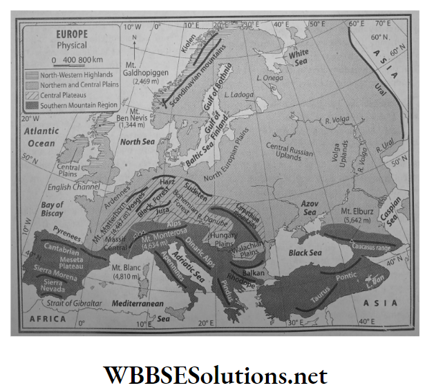
2. Northern and central plains:

Location:

  • North-central plains lie to the south of the north-west Highlands. This region extends from the Ural mountains in the east to the Atlantic Ocean and the Bay of Biscay in the west.
  • The southern part of the British Isles, the northern part of France, Netherlands, Belgium, Poland, the northern part of Germany, the western part of Russia – almost more than half of Europe falls under this physical region.

Characteristics:

  1. This extensive plainland has an average elevation of 180 metres.
  2. The main rivers of Europe, like the Rhine, Volga, Don, and Dnieper all flow through this plain land.
  3. The erosional activities of glaciers or the subsidence of land has caused the formation of several large lakes. For instance, Ladoga (area of 17,700 sq. km) and Onega (9,700 sq. km) in Russia. Among these, Ladoga is the largest lake in Europe.
  4. A large part of the Netherlands which takes up the north-west part of this plain has been reclaimed from the sea.

3. Central plateaus:

Location:

South of the north-central plains lies the dissected plateau of the Central Uplands. Spain, Germany and France fall under this physical region.

Characteristics:

  1. Geologically, this plateau is quite ancient. Erosional activities on fold mountains which were formed about many years ago have resulted in the formation of this plateau.
  2. The erosional activities of rivers have made this entire region a collection of small, separated plateaus. For example-Meseta of Spain, The Central Massif of France and the Don Massif of Russia.

4. Southern mountain region:

Location:

Almost all of southern Europe is part of the southern mountain region. From Spain in the west to France, Switzerland, Germany, Italy, Greece, Bulgaria, and Romania are all part of this physical zone.

Characteristics:

The Alps Mountain Range is a part of this region. The highest peak in the Alps is the Mont Blanc (4,810 m). It is situated in the border of France and Switzerland and is the second-highest peak in Europe.

Some mountain ranges have radiated from the Alps such as the Pyrenees, Cantabrian and the Caucasus ranges. The highest peak in Europe in Elburz (5642 m).

WBBSE Class 7 Geography Notes WBBSE Solutions For Class 7 History
WBBSE Solutions For Class 7 Geography WBBSE Class 7 History Multiple Choice Questions
WBBSE Class 7 Geography Multiple Choice Questions WBBSE Solutions For Class 7 Maths


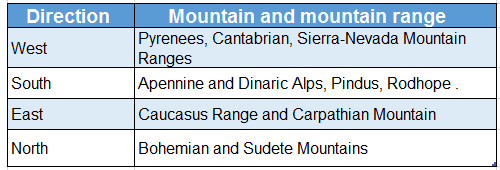
Question 4. Name the mountain ranges that are extended from the Alpine arc.
Answer:

Names of mountain ranges extending from the Alpine arc:

The Alps Mountain Range is located at the heart of the southern mountainous region. Different ranges are extended from the Alpine arc. These are as follows-

1. Towards west:

Mountain ranges that are extended towards the west are-

  1. Pyrenees (border of France and Spain),
  2. Cantabrian (in the north of France),
  3. Sierra Nevada (in the south of Spain).

2. Towards south:

Mountain ranges that are extended towards the south from the Alpine arc are-

  1. Apennine (Italy),
  2. Dinaric Alps (Serbia, Albania),
  3. Pindus (Greece),
  4. Rodhope

3. Towards north:

Mountain ranges that (Bulgaria, Turkey), etc. extended towards the north are-

  1. Bohemian and Jura Mountain (France),
  2. Massif and Sudetes Mountains (Czechoslovakia).

4. Towards east:

Mountain ranges that are extended towards the east are-

  1. Caucasus (in between the Black Sea and the Caspian Sea),
  2. Carpathian Mountain (Czech Republic, Slovakia),
  3. Balkan Mountain (Bulgaria).

Question 5. Describe the different climatic regions of the continent of Europe.
Answer:

Different climatic regions of the continent of Europe:

The continent of Europe can be divided into different climatic regions on the basis of regional variations of temperature and rainfall. These are as follows-

1. Tundra climate:

Location:

The northern part of Europe including Norway, Sweden, Finland and northern Russia experience the Tundra climate.

Temperature:

Summer temperature ranges between 0°C-10°C and in winter temperature ranges between -35°C to -45°C.

Rainfall:

Annual average precipitation is about 25 cm.

Characteristics:

This region is severely cold throughout the year.

  1. The duration of summer is very short.
  2. The temperature remains below freezing point and thus snowfall occurs.
  3. Land remains covered in ice for 9 to 10 months in a year.

WBBSE Solutions For Class 7 Geography Chapter 11 Topic A General Introduction Of The Continent Of Europe Climatic regions in Europe

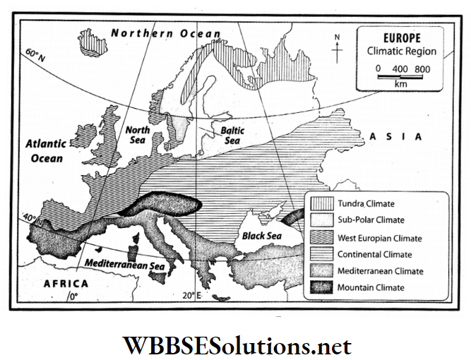
2. Sub-polar climate:

Location: Some parts of Sweden, Finland, Norway and Russia.

Temperature: Average summer temperature is 10°C and average winter temperature ranges between -25°C to -35°C.

Rainfall: This climatic zone experiences low rainfall in summer and snowfall in winter.

Characteristics:

  1. The duration of the summer season is 4-5 months.
  2. The temperature of winter months remains below freezing point and heavy snowfall occurs.
  3. The ground remains snow-covered for 6-8 months.
  4. Low rainfall in summer and huge snowfall in winter are the main features of this climate.

3. West European climate:

Location:

Some parts of the north-west Europe-United Kingdom, western France, western Germany, Holland, Denmark, Belgium and in some parts of Norway.

Temperature:

The summer temperature lies between 15°C-20°C and the winter temperature is 5°C.

Rainfall:

The annual average rainfall is 100- 150cm.

Characteristics:

  1. The temperature in summer and winter are moderate.
  2. Rainfall mostly occurs in winter due to westerlies.
  3. Snowfall occurs in the northwestern part of the continent during winter.

4. Mediterranean climate:

Location: Mediterranean coast including Italy, Spain, France, Greece, etc.

Temperature: Summer temperature ranges between 21°C-27°C and winter temperature ranges between 5°C-10°C.

Rainfall: Annual average rainfall is 40- 75 cm.

Characteristics:

  1. The main climatic feature of this region is dry summer and wet winter.
  2. Rainfall occurs in winter due to westerlies.

5. Continental climate:

Location: Central and Eastern Europe mainly Russia and Ukraine.

Temperature: Summer temperature ranges between 20°C-22°C and in winter temperature drops below freezing point.

Rainfall: Annual average rainfall is 25- 50 cm.

Characteristics:

  1. Hot summer and cold winter is the main feature of this climate.
  2. Rainfall mainly occurs in summer.

6. Mountain Climate:

Location: Alps, Caucasus, Carpathian mountainous region.

Temperature: Temperature remains below freezing point throughout the year.

Rainfall: Snowfall occurs throughout the year.

Characteristics:

  1. The weather remains cold throughout the year.
  2. In winter snowfall occurs.

Conceptual Questions on Europe’s Cultural Diversity

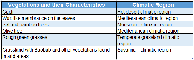
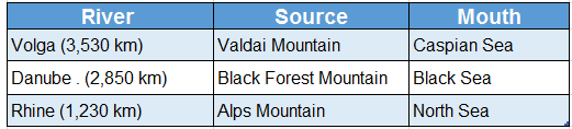
Question 6. Discuss the different categories of natural vegetation of Europe.
Answer:

The different categories of the natural vegetation of Europe:

The different categories of the natural vegetation of Europe are as follows-

1. Tundra forest:

Location: Northern part of Europe including Norway, Sweden, Finland and northern Russia experience the Tundra climate.

Species of trees: Moss, lichen, birch, willow, juniper, etc.

Climatic features:

  1. This region faces severe cold weather throughout the year.
  2. The duration of the summer season is very short.
  3. The temperature remains below freezing point and thus snowfall occurs.
  4. Land remains covered in ice for 9 to 10 months in a year.

Features of natural vegetation:

  1. Moss and lichen grow on the snow-covered ground.
  2. Once the snow melts trees like willow, birch and juniper grow. These are called Tundra shrubs.

2. Coniferous forest:

Location: Some parts of Sweden, Finland, Norway and Russia.

Species of trees: Pine, larch, fir, spruce, birch, alder, etc.

Climatic features:

  1. Duration of summer. the season is 4-5 months.
  2. The temperature of winter months remains below freezing point and heavy snowfall occurs during the season.
  3. The ground remains snow-covered for 6-8 months.
  4. Low rainfall in summer and huge snowfall in winter are the main features of this climate.

Features of natural vegetation:

  1. Trees are cone-shaped.
  2. Leaves are narrow and needle-shaped.
  3. The trees are softwood trees.

3. Temperate deciduous forest:

Location: Some parts of north-west Europe including the United Kingdom, western France, western Germany, Holland, Denmark, Belgium and in some parts of Norway.

Species of trees: Oak, elm, maple, alder, etc.

Climatic features:

  1. The temperature in summer and winter is moderate.
  2. Rainfall mostly occurs in winter under the influence of westerlies.
  3. Snowfall occurs in the northwestern part of the continent during winter.

Features of natural vegetation:

  1. Trees start shedding their leaves in autumn.
  2. These trees have lots of branches, leaves are large in size and the trees are hardwood trees.

WBBSE Solutions For Class 7 Geography Chapter 11 Topic A General Introduction Of The Continent Of Europe Natural vegetation of Europe

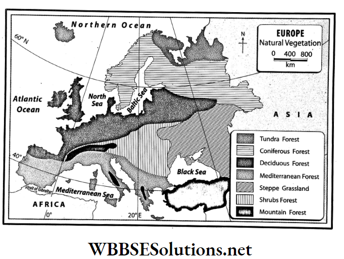
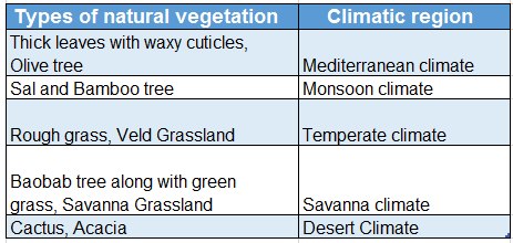
4. Mediterranean forest:

Location: Mediterranean coast including Italy, Spain, France, Greece, etc.

Species of trees: Olive, oak, cork, walnut, cedar, pine, fir, grapes, laurel, orange, etc.

Climatic feature:

  1. The main climatic feature of this region is dry summer and wet winter.
  2. Rainfall occurs in winter due to westerlies.

Features of natural vegetation:

  1. These trees are evergreen.
  2. They have long roots and thick leaves and bark.
  3. The leaves have a waxy coating in order to prevent water loss during evapotranspiration.

5. Steppe grasslands:

Location: Central and Eastern Europe, mainly Russia and Ukraine.

Species of trees: Willow, elm, maple, thorny bushes, shrubs, grasses.

Climatic features:

  1. Hot summer and cold winter is the main feature of this region
  2. Rainfall mainly occurs in summer.

Features of natural vegetation:

In these regions, some large trees such as willow grow along with shrubs and thorny bushes. These grasses are not very long.

6. Shrubs forest:

Location: Germany, Poland, France, Switzerland.

Species of trees: Oak, maple, poplar, alder, willow, etc.

Climatic features:

  1. A cold climate prevails all through the year.
  2. The maximum rainfall occurs in winter and snowfall also occurs.

Feature of natural vegetation:

Deciduous, evergreen and coniferous trees grow together in these forests.

7. Mountain forest:

Location: Alps, Apennine, Pindus, Caucasus, Carpathian mountainous region.

Species of trees: Pine, poplar, alder, etc. Climatic feature: Temperatures remain below freezing point.

Features of natural vegetation:

  1. Trees are cone-shaped.
  2. The trees are softwood trees.

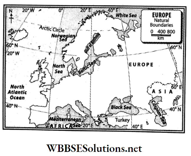
Question 7. Mention the boundaries of the continent of Europe.
Answer:

Boundaries of the continent of Europe:

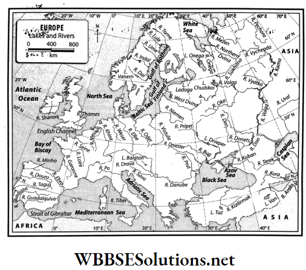
Europe is bounded on the north by the Arctic Ocean, the White Sea, the Gulf of Bothnia, the Gulf of Finland and the Baltic Sea; on the south by the Straits of Gibraltar, the Mediterranean Sea, the Adriatic Sea, the Black Sea, the Ionian Sea, the Aegean Sea and the Tyrrhenian Sea; on the west by the Atlantic Ocean, the Bay of Biscay and the North Sea.

To the east, Europe is bounded by the continent of Asia. Apart from this, a narrow part of the east is bounded by the Caspian Sea.

WBBSE Solutions For Class 7 Geography Chapter 11 Topic A General Introduction Of The Continent Of Europe Natural boundaries of Europe

Question 8. In your opinion, in which direction is the general slope of Europe and why?
Answer:

The middle and southern parts of the continent of Europe are taken up by high mountains and dissected highlands and high plains. So, the land of the continent of Europe slopes in three directions-

  1. From the middle to the north
  2. From the middle to the south
  3. From the middle to the west

Reasons:

We know that rivers usually flow from the higher lands to the lower lands. In Europe, the rivers flow in three directions which are as follows-

1. North-flowing rivers:

These rivers flow to the north from central Europe. The main among these are Seine, Rhine, Elb, Vistula and Oder.

2. West-flowing rivers:

These rivers flow to the west from central Europe. The main among these are Minho, Douro, Tagus and Guadiana.

3. South-flowing rivers:

These rivers flow to the south from central Europe, for example-Po, Danube, Dnieper, etc.

Question 9. Give a description of the north-western highlands or the western uplands.
Answer:

North-western highlands or the western uplands:

In the north-west part of Europe lies the mountainous region of the Scandinavian peninsula (Norway and Sweden are part of this peninsula), the mountainous region of Finland, the northern and central parts of the British Isles and the hilly regions of northern Ireland are all parts of this physical region.

Characteristics:

  1. This is a dissected plateau, separated by deep valleys and fjords.
  2. This is made up of old volcanic and metamorphic rocks.
  3. Several fjords and lakes can be observed in the coastlines of Finland, Norway and Sweden. That is why Finland is known as the country of lakes.

Question 10. Give a description of the northern and central plains.
Answer:

Northern and central plains:

To the south of the north-western highlands, lie the north-central plains that extend from the Ural Mountains in the east to the Atlantic Ocean and the Bay of Biscay in the west.

The southern part of the British Isles, the northern part of France, Netherlands, Belgium, Poland, the northern part of Germany, the western part of Russia – almost more than half of Europe falls under this physical region.

Characteristics:

  1. This extensive plainland has an average elevation of 180 metres.
  2. The main rivers of Europe such as the Rhine, Volga, Don, and Dnieper all flow through this region.
  3. The erosional activities of glaciers or the subsidence of land has formed several large lakes, such as Ladoga (17,700 sq. km) and Onega (9,700 sq. km) in Russia. Ladoga is the largest lake in Europe.
  4. A large part of the Netherlands i.e. the north-west part of this region has been reclaimed from the sea. This land. is known as polderland.

Question 11. What do you know about the central uplands of Europe?
Answer:

Central uplands of Europe:

In the south of the north-central plains lies the dissected plateau of the central uplands. Spain, Germany and France fall under this physical region.

Characteristics:

  1. Geologically, this plateau is quite ancient. Erosional activities on fold mountains which were formed about many years ago have resulted in the formation of this plateau.
  2. The erosional activities of rivers have made this entire region a collection of small, separated plateaus.

For example-

  1. Meseta of Spain,
  2. The central Massif of France and
  3. Don Massif of Russia, etc.

Real-Life Scenarios Involving European Rivers and Mountains

Question 12. Write about the southern mountainous region of Europe.
Answer:

Southern mountainous region of Europe:

Almost all of southern Europe is part of the southern mountain region. From Spain in the west to France, Switzerland, Germany, Italy, Greece, Bulgaria, and Romania are all part of this physical zone.

The Alps Mountain Range is a part of this region. The highest peak in the Alps is the Mont Blanc (4,807 m). It is situated in the border of France and Switzerland and is the second-highest peak in Europe.

The highest peak in the Caucasus range is Mt. Elburz (5642m). It is the highest peak in Europe. Some mountain ranges have radiated from the Alps which are-

WBBSE Solutions For Class 7 Geography Chapter 11 Topic A General Introduction Of The Continent Of Europe Mountain and mountain range and directions


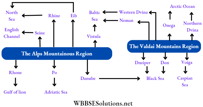
Question 13. Classify the rivers of Europe.
Answer:

Rivers of Europe:

Most of the rivers of Europe originate in the Central Uplands and then flow in various directions. On the basis of the direction in which they flow, the rivers of Europe can be classified into four types. These are-

  1. North-flowing: Elb, Vistula, Pechora, North Dvina, Onega, etc
  2. West-flowing: Seine, Rhine, Loire, West Dvina, Neman
  3. South-flowing: Danube, Dnieper, Don, Po, Rhone
  4. Inland: Volga, Ural

WBBSE Solutions For Class 7 Geography Chapter 11 Topic A General Introduction Of The Continent Of Europe Classification of the rivers of Europe

Question 14. What are the special features of European rivers?
Answer:

The special features of the rivers of Europe are as follows-

  1. Most European rivers are snow-fed and so, they are perennial.
  2. Most rivers have originated from the Central Uplands and the southern mountainous region.
  3. Most of these rivers are fast-flowing.
  4. These rivers help to generate hydel power.
  5. Most of the rivers are navigable.
  6. Most of the rivers are not very long.
  7. The north-flowing rivers in Europe remain covered in ice for about 3-4 months of the year and when the snow or ice melts in spring and autumn, the rivers often flood their banks.

WBBSE Solutions For Class 7 Geography Chapter 11 Topic A General Introduction Of The Continent Of Europe Lakes and rivers of Europe

Question 15. Describe the temperature range in Europe.
Answer:

The temperature range in Europe:

In summer, the south-eastern parts of the continent experience average temperatures of about 27°C and the north experiences temperatures of about 14°C.

WBBSE Solutions For Class 7 Geography Chapter 11 Topic A General Introduction Of The Continent Of Europe pattern of temperature in summer in Europe


WBBSE Solutions For Class 7 Geography Chapter 11 Topic A General Introduction Of The Continent Of Europe pattern of temperature in Winter in Europe

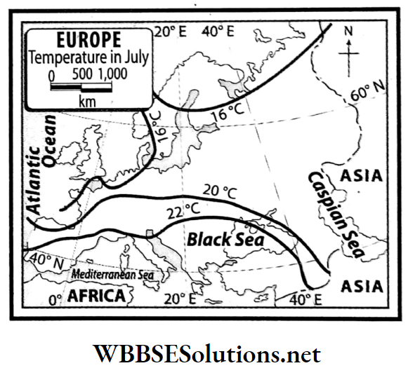
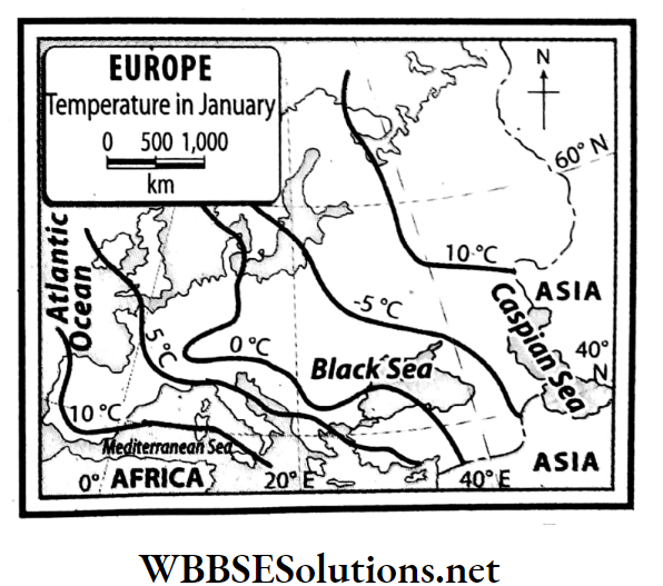
  • Again, in winter, warm currents cause the temperatures to drop moderately in the western parts to some extent but the temperatures drop significantly in the eastern and central parts of the continent.
  • In the northeast stretches of the continent, around this time, the temperature stays below the freezing point (-14°C).

Examples of Real-Life Applications of European Geography

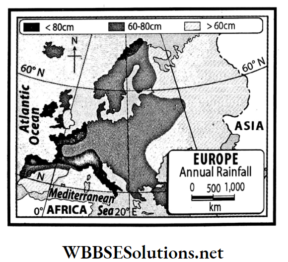
Question 16 Write what you know about the variations of rainfall patterns in Europe.
Answer:

In summer, apart from some areas in southern Europe, moisture-laden westerly winds cause rainfall. Again, in winter, westerly winds bring rainfall to the entire continent.

  • However, the average annual rainfall is higher in the west and southern coastal areas than in the inland areas of the continent. The average annual rainfall in the coast of Finland is above 200 cm.
  • Southern and central Europe experience about 50-100 cm average rainfall and in the western areas, average rainfall is in the range of 25-50 cm.

However, the Alps, the Pennines and other mountainous regions receive about 100-200 cm of rainfall annually.

WBBSE Solutions For Class 7 Geography Chapter 11 Topic A General Introduction Of The Continent Of Europe Rainfall patterns in Europe

Question 17. Name the natural vegetation zones in Europe.
Answer:

The natural vegetation zones in Europe:

  • The natural vegetation of any region is determined by the climate of that region.
  • The temperature of the air, amount of rainfall, and moisture content of the air are all factors of climate that influence the nature and form of the natural vegetation of that region.
  • Based on the climate, the continent of Europe can be divided into seven natural vegetation zones.

These are-

Tundra forest,

  1. Coniferous forest,
  2. Deciduous forest,
  3. Mediterranean forest,
  4. Woodlands,
  5. Mountain forest,
  6. Steppe grassland.

Question 19. Write about the special characteristics of the vegetation of the Coniferous forests.
Answer:

The special characteristics of the vegetation of Coniferous forests are as follows-

  1. The trees are usually conical in shape and have downward-drooping limbs to help them shed snow.
  2. Trees are tall and without many branches, and leaves are needle-shaped.
  3. Trunks are of softwood.

Question 18. Can you find any similarities between these two maps?
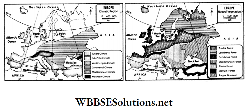
WBBSE Solutions For Class 7 Geography Chapter 11 Topic A General Introduction Of The Continent Of Europe Climatic and Natural vegetation of Europe

Answer:

The characteristics of the natural vegetation of any region depend on the temperature and rainfall of that region. So there are many similarities between the maps of climate and the natural vegetation of a region. These are-

WBBSE Chapter 11 Continent Of Europe Topic A General Introduction Of The Continent Of Europe Short Question And Answers

Question 1. Explain why dissected plateaus have developed in central Europe.
Answer:

  • Millions of years ago, fold mountains were formed in central Europe. With the passage of time, as processes of erosion acted on them, the fold mountains became reduced to a plateau. In France and Germany, this is known as the Hersenean plateau.
  • Earlier, this existed at a stretch from the plateau region of Spain and France to the Caucasian and Anatolian highlands. This plateau was then reduced when various factors acted on it.
  • Several faults were also formed-this finally resulting in a dissected plateau.

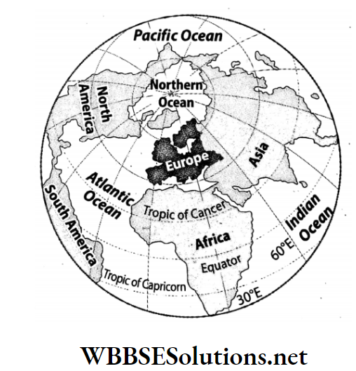
Question 2. Mention the names of three major rivers in Europe and their source and mouth.
Answer:

The three major rivers along with their sources and mouths are tabulated below.

WBBSE Solutions For Class 7 Geography Chapter 11 Topic A General Introduction Of The Continent Of Europe Major rivers along with source and mouth

Question 3. Describe the course of the river Danube.
Answer:

The course of the river Danube:

  • The Danube is the second longest river of Europe with a length of about 2,850 kilometres. The source of the Danube is in the Black Forest region of the German Alps.
  • The river then flows through Germany, Austria, Czech Republic, Slovakia, Hungary, Serbia, Romania and Bulgaria before discharging into the Black Sea. This river is an important international waterway and the primary international river of Europe.
  • Sava, and Drava are its main tributaries. Many important cities and towns have developed and flourished on its banks like Vienna in Austria, Budapest in Hungary and Belgrade in Serbia.

Question 4. Write about the course of the river Volga.
Answer:

The course of the river Volga:

  • The Volga is the longest river of Europe with a length of about 3,530 kilometres. The source of the Volga is in the Valdai Mountains to the northeast of Moscow in Russia.
  • After this, the river flows through the eastern part of Russia and then discharges into the Caspian Sea. Two important tributaries of the Volga are the Oca and Kama.

Question 5. Why are the north-flowing rivers of Europe are flood-prone?
Answer:

  • The rivers of Pechora, Megen, Onega, West Dvina, North Dvina and other north-flowing rivers flow from the low latitudes to the high latitudes.
  • This means that as the rivers flow from a hotter to a less hot region and during the spring the ice of the source region starts melting, but the mouth region is still frozen. This is why the north-flowing rivers of Europe are flood-prone.

Question 6. What are the special characteristics of the climate of Europe?
Answer:

The special characteristics of the climate of Europe:

Broadly speaking, the climate of the whole of Europe is mainly of temperate type. This type of climate is usually pleasant and moderate. During any time of the year, some parts or other parts of the continent experience rainfall.

The reason for this is:

  1. About 90% of Europe falls in the temperate zone and 10% falls in the frigid zone.
  2. No part of this continent is too far from the seas or oceans.
  3. The hot North Atlantic current flows along the western coastline of the continent throughout the year.
  4. Though the northeast trade winds blow over some parts of southern Europe in the summer, the westerlies blow over most areas of Europe throughout the year.
  5. The Alps Mountainous Region also influences the climate of the continent.

Question 7. What are the wind patterns that are observed over Europe?
Answer:

  • Mostly, planetary winds blow over the continent of Europe. In the northern hemisphere, in summer the pressure belts move a little to the north and so, the dry north-east trade winds blow over southern Europe and the rest of the continent experiences moisture-laden westerlies.
  • In winter, the pressure belts shift south. Because of this, westerly winds blow over the whole of Europe. However, at that time, eastern-central Europe experienced severe cold and so a high-pressure zone developed over this region.
  • As a result, the interiors of the continent do not experience much wind or breeze.

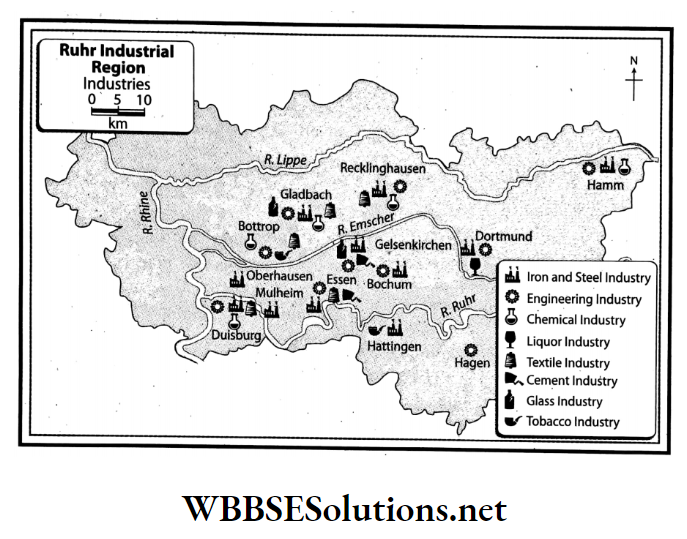
Question 8. Write a note on why Europe is supposed to be the industrially most developed in the world.
Answer:

  • Favourable environmental and economic factors are the major cause of the industrial development of Europe.
  • Several industries such as the iron and steel industry, engineering industries (motor vehicle manufacturing, aircraft construction and such others), chemical, paper, woollen textile, aluminium, electronics and others have grown in this region.
  • The most developed industrial region of Europe is Ruhr in Germany, the Donetz Basin of Ukraine, Moscow in Russia, the Paris Basin of France and the London Basin of the British Isles. This is why Europe is thought to be the industrially most developed in the world.

Question 9. Which climatic regions of Europe, do you think, are expected to be the most and least populous?
Answer:

  • In Europe, the countries with the highest population density are the Netherlands, Belgium, Germany, the British Isles, Italy and so on. These countries fall in the temperate and Mediterranean climatic zones.
  • Again, areas with low population density such as Sweden, Norway, and northern parts of Russia are part of the Tundra climatic zone and have the tundra and alpine forest zones.

Question 10. State the area of Europe.
Answer:

Area of Europe:

  • In terms of area, Europe is the sixth-largest continent in the world. Its area is only 10.9 million square kilometres. Though it is about three times the area of India, it is just 1/4 of the total land area of the continent of Asia.
  • Europe takes up about 6.8 per cent of the total land area of the Earth.

Important Definitions Related to European Geography

Question 11. What is meant by Eurasia?
Answer:

Eurasia:

  • Since there is no geographical boundary between the continents of Europe and Asia, (apart from the Ural highlands, Ural river and the Caspian Sea), these two continents together form a gigantic, continuous landmass.
  • This landmass is known as Eurasia. In Eurasia, climate, soil, flora fauna etc. are all similar.

Question 12. What is the location of the continent of Europe with respect to both latitudes and longitudes?
Answer:

The continent of Europe extends from the 35° N latitude (Cape Tarifa in Spain) to 71° N latitude (North Cape in Norway) and from 65° East longitude (Ural highlands) to 24° West longitude (westernmost point in Iceland).

WBBSE Solutions For Class 7 Geography Chapter 11 Topic A General Introduction Of The Continent Of Europe The location of Europe on the globe

Question 13 Name the main bays and the main peninsulas which are situated at the boundaries of Europe.
Answer:

The main bays which lie on the boundaries of the continent of Europe are the Gulf of Lyon, the Gulf of Finland, the Bay of Riga, Genoa Bay, the Bay of Biscay, and the Gulf of Bothnia.

The main peninsulas are-

  1. Balkan Peninsula,
  2. Crimean Peninsula,
  3. Italian Peninsula,
  4. Scandinavian Peninsula.

Question 14. Mention the major cities of Europe.
Answer:

The major cities of the continent of Europe are-

  1. London,
  2. Paris,
  3. Amsterdam,
  4. Rome,
  5. Berlin,
  6. Moscow,
  7. Madrid,
  8. Vienna etc.

Question 15. What are the physical divisions of Europe?
Answer:

Physical divisions of Europe:

The topography of the continent of Europe is very diversified. Based on the variety of landforms, Europe can be divided into the following 4 physical divisions:

  1. North-western highlands or Western the south are mostly in Italy such as Etna on the Uplands
  2. Northern and Central plains
  3. Central plateaus
  4. Southern mountain region

Question 16. What is meant by the ‘Lighthouse of the Mediterranean?
Answer:

Lighthouse of the Mediterranean:

  • The Stromboli volcano is situated on the island of Lipari in the Mediterranean Sea. This is an active volcano with continuous minor eruptions. Due to these small but regular eruptions, Stromboli is visible from a large area around it.
  • Luminous phosphorus gas is also released along with this eruption. So it seems as if the mouth of the volcano is always glowing. Thus, Stromboli has come to be known as the ‘Lighthouse of the Mediterranean’.

Question 17. Write a short note on the volcanoes of Europe.
Answer:

Volcanoes of Europe:

  • There are some volcanoes in the western and southern parts of Europe. In the west, there are Krafla and Hekla in Iceland. The volcanoes in island of Sicily, Stromboli on the island of Lipari, Vesuvius in eastern Italy and so on.
  • Stromboli is an active volcano with minor eruptions that happen almost hourly. These small but regular eruptions throw out glowing lava and make Stromboli visible from a large area around. Stromboli is known as the ‘Lighthouse of the Mediterranean’.

Question 18. Write the names of the main rivers flowing through Europe.
Answer:

Among the rivers flowing through Europe, the following are significant-

  1. Volga,
  2. Danube,
  3. Don,
  4. Rhine,
  5. Rhone,
  6. Po,
  7. Seine,
  8. Thames,
  9. Dnieper,
  10. Dniester,
  11. The Vistula,
  12. Dvina,
  13. Pechora,
  14. Elb etc. Volga (3692 km) is the longest river in Europe.

Question 19. Write the names of the riverine plains of Europe.
Answer:

In the southern part of Europe, riverine plains lie between the ridges and peaks of the fold mountain region.

Erosional and depositional activities of the rivers flowing through this region over millions of years have resulted in the formation of these plains. Some examples are-

  1. Rhone Plain in France.
  2. Po River Basin in Italy.
  3. Hungarian Plain.
  4. Danube plains in Romania and Bulgaria and so on.

Question 20. Write a short note on the river Rhine.
Answer:

River Rhine:

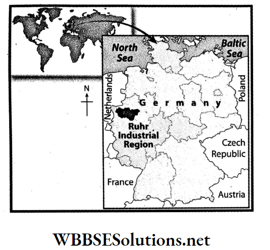
  • The main river of the Ruhr industrial region in Germany is the river Rhine. Its entire length is 1,233 km. After originating in the Alps Mountains, it flows through Switzerland.
  • Then it flows through the rift valley between the Black Forest Mountains in Germany and the Vosges Mountains in France. After that, it enters the Netherlands and then finally discharges into the North Sea.
  • The main tributaries of the river Rhine are the Lippe, Aare, Neckar, and Main.

Question 21. What do you mean by an ‘International river’?
Answer:

‘International river’:

  • A river that flows through more than one country along its course from source to mouth is known as an International river.
  • For instance, the Danube in Europe, the Nile in Africa, and the Indus and the Brahmaputra in India are all examples of International rivers. The Danube in Europe flows through ten sovereign countries.
  • These rivers have great significance as international waterways.

Question 22. How many climatic regions can we divide Europe into? What are they?

On the basis of differences in temperature and rainfall patterns, Europe can be divided into a few climatic zones.

These are-

  1. Tundra climate,
  2. Sub-polar climate,
  3. West European climate,
  4. Continental climate,
  5. Mediterranean climate,
  6. Mountain climate.

Question 23. What is Steppe grasslands?
Answer:

Steppe grasslands:

The temperate grasslands found in the continental climate in the central and eastern parts of Europe are called Steppe grasslands.

Location:

The western part of Russia and the coastal region of the Black Sea in Ukraine.

Characteristics:

The annual average rainfall is low. So, the grasslands have been created here. Along the banks of the rivers willow, elm, maple etc trees are found

WBBSE Chapter 11 Continent Of Europe Topic A General Introduction Of The Continent Of Europe Very Short Question And Answers

Question 1. Which is the sixth-largest continent in the world?
Answer: Europe.

Question 2. How many nations are there in Europe?
Answer: 56.

Question 3. In terms of population, where does Europe rank?
Answer: Third.

Question 4. What is the northernmost boundary of the continent of Europe?
Answer: North Cape in Norway.

Question 5. What is the southernmost boundary of the continent of Europe?
Answer: Cape Tarifa in Spain.

Question 6. What is the westernmost boundary of the mainland of Europe?
Answer: Cape Roca in Portugal.

Question 7. Which strait separates Europe from Africa?
Answer: Gibraltar.

Question 8. Which country is called the ‘land of the midnight sun’?
Answer: Norway.

Question 9. Which country in Europe is known as the ‘Country of Thousand Lakes’?
Answer: Finland.

Question 10. What do you call a place where many mountain ranges converge?
Answer: Mountain Arc.

Question 11. Which is the highest peak in the Alps?
Answer: Mont Blanc.

Question 12. What do we mean by the “Lighthouse of the Mediterranean”?
Answer: Stromboli Volcano.

Question 13. Which is the highest peak in Europe?
Answer: Elburz in the Caucasus Mountains.

Question 14. Mention two block mountains of Europe.
Answer: Vosges Mountain and Black Forest Mountain.

Question 15. Which is the longest river in Europe?
Answer: Volga.

Question 16. Which is the most important international river in the world?
Answer: Danube.

Question 17. What is the name of the largest lake in Europe?
Answer: Ladoga.

Question 18. What kind of climate does Europe have?
Answer: Temperate.

Question 19. In which parts of Europe is the coniferous forest found?
Answer:

In the middle of the 50°-70° north latitude of the continent of Europe, coniferous forests are found in parts of Norway, Sweden, Finland and some parts of Russia. The coniferous forest in Europe is known as Taiga.

Question 20. In Europe, which climatic zones are densely populated and which climatic zones are sparsely populated?
Answer:

In Europe, regions which experience the temperate marine climate and those which fall under the Mediterranean climatic zone are densely populated. Regions which are categorised as experiencing the Tundra climatic type are sparsely populated.

Question 21. Where is the Strait of Gibraltar located?
Answer:

The narrow strip of water (about 13 km wide and 300 metres deep) that connects the Mediterranean Sea to the Atlantic Ocean is known as the Strait of Gibraltar. This strait also acts as a geographic divide between Spain in Europe and Morocco in Africa.

WBBSE Chapter 11 Continent Of Europe Topic A General Introduction Of The Continent Of Europe Fill In The Blanks

Question 1. The continent of Europe is in the _________ hemisphere.
Answer: Northern

Question 2. The _________ of Europe were formed because of the erosional activities of glaciers in the Ice Age.
Answer: Fjord

Question 3. Europe’s highest peak, _________is part of the _________ range.
Answer: Elburz, Caucasus

Question 4. Two mountain passes in the Alps Mountain range are _________ and _________.
Answer: Brenner, Simplon

Question 5. _________ in France and in Germany are two examples of block mountains.
Answer: Vosges, Black Forest

Question 6. Two mention-worthy peaks in Switzerland are _________ and _________.
Answer: Monte Rosa, Matterhorn

Question 7. The _________ volcano in the Lipari islands is known as the ‘Lighthouse of the Mediterranean.’
Answer: Stromboli

Question 8. The two water divides in Europe are and _________.
Answer: Alps, Valdai

Question 9. _________ is the biggest lake in Europe.
Answer: Ladoga

Question 10. The source of the river Rhone is in the _________ region.
Answer: Alps Mountain

Question 11. Europe’s longest river, the _________, has its origin in the Mountain.
Answer: Volga, Valdai

Question 12. Aine is a tributary of river _________.
Answer: Rhone

Question 13. The longest river of France is _________.
Answer: Seine

Question 14. Paris is situated on the banks of the river _________.
Answer: Seine

Question 15. The climate of Europe is primarily of the _________ type.
Answer: Temperate

Question 16. Mostly _________ forests grow in Europe.
Answer: Coniferous

Question 17. The name of the world’s largest coniferous forest is _________.
Answer: Taiga

WBBSE Chapter 11 Continent Of Europe Topic A General Introduction Of The Continent Of Europe True Or False

Question 1. The longest river of Europe is river Volga.
Answer: True

Question 2. Moscow is called the ‘Port of Five Seas’.
Answer: True

Question 3. Poland is called the ‘City of Thousand Lakes’.
Answer: False

Question 4. The famous volcano in the island of Sicily is Stromboli.
Answer: False

Question 5. The highest peak in the Alps is Mt. Elburz.
Answer: False

Question 6. The Pyrenees is at the boundary of Spain and France.
Answer: True

Question 7. The largest lake in Europe is Onega.
Answer: False

Question 8. The highest peak in Europe is Mont Blanc.
Answer: False

Question 9. The river Rhine flows through the rift valley between the Vosges Mountains in France and Black Forest Mountains in Germany.
Answer: True

Question 10. The longest river in Europe is the Danube.
Answer: False

Question 11. The most important international river in Europe is the Volga.
Answer: False

Question 12. The boundary between Europe and Asia is delineated by the Ural Mountains.
Answer: True

Question 13. Meseta is a famous plateau of Spain.
Answer: True

Question 14. The Seine River discharges into the English Channel.
Answer: True

Question 15. Moscow is a large city in the northernmost part of the world.
Answer: True

Question 16. In places with a Mediterranean climate, convectional rainfall occurs every evening.
Answer: False

WBBSE Chapter 11 Continent Of Europe Topic A General Introduction Of The Continent Of Europe Match The Columns
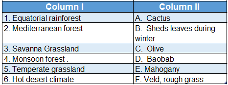
Question 1.WBBSE Solutions For Class 7 Geography Chapter 11 Topic A General Introduction Of The Continent Of Europe Match The Columns

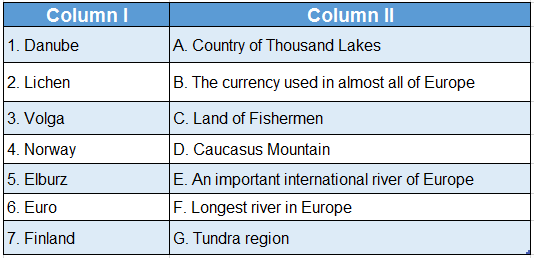
Answer: 1. E, 2. G, 3. F, 4. C, 5. D, 6. B, 7. A

WBBSE Solutions For Class 7 Geography Chapter 10 Continent Of Africa Topic B Nile Basin Notes

WBBSE  Chapter 10 Continent Of Africa Topic B Nile Basin Long Question And Answers

Question 1. Describe the course of the River Nile.
Answer:

The course of River Nile:

The Nile is the longest river of the world. The length of the River Nile is 6650 km. According to physiography, the course of the Nile can be divided into 6 divisions. They are-

  1. Source region,
  2. The upper course of the river,
  3. The middle course of the river,
  4. The lower course of the river,
  5. Delta region.

1. Source region:

This region extends from the Burundi Highlands of Tanzania to Lake Victoria.

2. Upper course of the river:

This region extends from Lake Victoria to Malakal of Sudan. Several huge waterbodies have also formed in this region.

3. Middle course of the river:

This region extends from Malakal to Khartoum. It is a region of undulating stretch of Savanna Grassland.

Read And Learn Also WBBSE Solutions For Class 7 Geography

4. Lower course of the river:

This division extends from Aswan to Cairo, both in Egypt. The river descends in six steps, forming six waterfalls.

5. Delta region:

The delta course of the Nile River forms from Cairo to the Medi- terranean Sea. The discharge of the river gets divided into seven distributaries over here. This region is an agriculturally fertile alluvial plain.

WBBSE Solutions For Class 7 Geography Chapter 10 Continent Of Africa Topic B Nile Basin

Question 2. Delineate the course of the River Nile through a picture.
Answer:

The course of the River Nile through a picture:

WBBSE Solutions For Class 7 Geography Chapter 10 Continent Of Africa Topic B Nile Basin Courses of the river nile


Question 3. How important is irrigation for agriculture in Egypt?
Answer:

Importance of irrigation for agriculture in Egypt:

  • The average annual rainfall in Egypt is less than 25 cm. But as the sources region of the Nile receives heavy rainfall, floods are experienced in Egypt.
  • As a result of this, the arid region of Egypt also gets covered by silt and agriculture becomes possible. Agriculture in Egypt has become one of the main sources of livelihood.
  • The major reason behind this is the fertile silt, deposited by the Nile and the irrigation facility that is available along the course of the river. As a result, high-quality cotton, wheat, banana, tobacco, millet, almond and such other crops grow here.
  • The Aswan High Dam reaps massive benefits to the Egyptian economy. The annual Nile flood could be controlled by man, for the first time in history after the Aswan Dam was built.
  • The floodwater is stored in the reservoir, with a scope to utilise it for irrigation, to increase the navigability of the Aswan Dam and to generate an enormous amount of hydel electricity. All these facilities, together lead to the development of agriculture.
WBBSE Class 7 Geography Notes WBBSE Solutions For Class 7 History
WBBSE Solutions For Class 7 Geography WBBSE Class 7 History Multiple Choice Questions
WBBSE Class 7 Geography Multiple Choice Questions WBBSE Solutions For Class 7 Maths

Question 4. What is a multipurpose river valley project? What are the main objectives of such a project on the River Nile? 
Answer:

Multipurpose River Valley Project:

When a dam is built on a river with many objectives, it is known as a multipurpose river valley project. For example, Aswan High Dam on the River Nile, Maithon Dam on the River Barakar, etc.

Objectives of the Multipurpose River Valley Project:

The objectives of the multipurpose river valley project are as follows-

  • Irrigation system: Canals are dug from the reservoir to irrigate the agricultural lands of the river basin throughout the year.
  • Flood control: Reservoirs are constructed to retain excess rainwater. As a result, the basin is protected from flooding.
  • Hydropower generation: Hydropower is generated by turning water from the reservoir at high speed.
  • Water transportation system: As there is water all year round in the main river and artificial canals, the facility of easy transportation is availed through waterways.
  • Fish cultivation: Since reservoirs and canals are perennial all year round, fish farming can easily be done.
  • Tourist centre: The dam and reservoir attract tourists from everywhere.

Question 5. Write about the minerals and industries of the Nile River Basin.
Answer:

Minerals of the Nile River Basin:

The Nile River Basin is not that rich in mineral deposits. However, certain minerals found in the region are-

Egypt: Mineral oil, mineral salt, gypsum, iron ore, phosphate, etc.

Sudan: Manganese, copper, iron ore, mica, etc.

Industries of the Nile River Basin:

Although the Nile River Basin is not rich in mineral deposits, yet

  1. Easy availability of agricultural raw materials,
  2. Developed transport network,
  3. Abundant availability of water,
  4. Easy availability of hydroelectricity,
  5. The easy availability of skilled labour has facilitated the development of various industries, of which the agricultural industries are prime.

For example, the cotton textile industry (Alexandria and Cairo), the meat processing industry (Sudan and Cairo), the paper industry, the cement industry, the woollen industry, the automobile industry, the leather industry (Alexandria, Sudan, Port Said), etc.

Question 11. Write a note on the Aswan High Dam.
Answer:

Aswan High Dam:

Aswan High Dam is a rock-fill dam that is 111 m high and 3830 m long in Aswan, Egypt. It was constructed at the cost of 1 billion dollars in 1970.

  • Lake Nasser, the enormous reservoir, backs up the Nile about 320 km in Egypt and almost 160 km farther upstream in Sudan.
  • The Aswan High Dam reaps massive benefits for the Egyptian economy.
  • The annual Nile flood could be controlled by man, for the first time in history after the Aswan Dam was built.
  • The flood water is stored in the reservoir, with scope to utilise this for irrigation, to increase the navigability of the Aswan Dam and to generate an enormous amount of hydel electricity. It also supports fishing.

Question 12. Describe the course of the River Nile.
Answer:

The course of the River Nile:

  • Nile is the longest river of the world. The length of the River Nile is 6650 km. The White Nile and the Blue Nile join to form the River Nile.
  • White Nile rises from the Burundi Highlands, which is 50 km away from Lake Tanganyika and Lake Victoria in Tanzania.
  • On the other hand, the Blue Nile rises from the Ethiopian Highlands and meets the White Nile near Khartoum in Sudan.
  • From here the Nile flows a long way through the deserts of Egypt and near Cairo, bifurcates into 7 distributaries. Here the Nile forms its exemplary delta and falls into the Mediterranean Sea.

Question 13. Draw a chart to state the reasons for the River Nile being perennial and flooding of the Nile Basin.
Answer:

The following chart explains the reasons for the River Nile being perennial and flooding of the Nile Basin.

WBBSE Solutions For Class 7 Geography Chapter 10 Continent Of Africa Topic B Nile Basin Flood in the lower course of river nile

Question 14. Why is the Nile a perennial river?
Answer:

  • The two major tributaries of the Nile are White Nile and the Blue Nile. The White Nile originates from Burundi Highlands and Lake Victoria.
  • This river flows through the equatorial region and thus receives a good amount of rainfall.
  • The Blue Nile originates from the Tana Lake in the highlands of Ethiopia. This river gets an adequate amount of rainfall as it flows through the region of monsoon climate.
  • As these two rivers with adequate amounts of water join together to form the River Nile. Thus it is a perennial river.

Understanding the Nile River

Question 15. Discuss the important climatic characteristics of the Nile River Basin.
Answer:

The important climatic characteristics of the Nile River basin are discussed in the following table:

WBBSE Solutions For Class 7 Geography Chapter 10 Continent Of Africa Topic B Nile Basin Climatic Characteristics of the Nile river basin


Question 16. Find out the significance of river planning on agriculture in the Nile River Basin.
Answer:

The River Nile does not cause floods all through the year and so, agriculture becomes difficult in the dry seasons.

To manage this problem, river planning has been done and dams as well as reservoirs have been constructed on the tributaries of River Nile. These dams and reservoirs are listed as follows-

  1. Aswan Dam on the River Nile, with Nasser Lake to support it.
  2. Sennar Dam on the Blue Nile.
  3. Khashm el-Girba Dam on River Atbarah.

Apart from this, some other irrigation dams have also been constructed for the convenience of agriculture.

These are-

  1. Delta Barrage,
  2. Esna Barrage,
  3. Assiut Barrage.

Countless canals and minor sub-canals have been dug on either side of the river. Water is supplied to the floodplains of the Nile and even away from it through these canals to facilitate agricultural activities.

WBBSE Solutions For Class 7 Geography Chapter 10 Continent Of Africa Topic B Nile Basin Nile river basin

WBBSE  Chapter 10 Continent Of Africa Topic B Nile Basin Short Question And Answers

Question 1. Why has the River Nile made the desert green in Egypt?
Answer:

  • Almost 10% of the water flowing through the continent of Africa flows through the Nile. Two of its tributaries, the Blue Nile and the White Nile have made the desert green in Egypt.
  • Dams built on the Nile have been effective enough to control flood, and water from these dams are then used for agriculture through canals.
  • Agriculture flourishes in the delta region of the Nile due to rich silt deposition.
  • Since Egypt is located in the lower course of the river, the desert region of Egypt has turned green due to the presence of the Nile.

Question 2. Describe the natural vegetation cover of the Nile River Basin.
Answer:

The natural vegetation cover of the Nile River Basin is discussed in the following table-

WBBSE Solutions For Class 7 Geography Chapter 10 Continent Of Africa Topic B Nile Basin Ntural vegetation cover of the Nile river basin

Question 3. Name the most important agricultural crops of the Nile River Basin.
Answer:

  1. The most important agricultural crop of the Nile River Basin is cotton. In Egypt and Sudan huge quantities of long-staple cotton are grown. The cotton grown in this region has a huge demand in the international market.
  2. The other important crops of the region are- paddy, wheat, sugarcane, maize, tobacco, jowar, barley, almond and date. The major crops of the upper course of the river are tobacco, banana and coffee, etc.
  3. The crops of the middle course are wheat, date palm, jowar, almond, etc. The crops of lower course are olive, barley, maize, etc. The crops of the delta region are rice, wheat, cotton, etc.

Question 4. What measures can be taken to prevent the floodwater?
Answer:

  • The River Nile gets flooded every year from the month of June of September. This excess floodwater needs to be stored separately, or else the lower course of the river will be completely flooded.
  • Thus, several dams have been constructed on the course of the river. These dams hold the excess floodwater and thus help in controlling floods.
  • The water from the dams is then diverted to the dry agricultural fields to facilitate irrigation in the arid regions. Thus, in addition to flood control, agricultural activities are also enhanced.
  • At times, deep cavities are dug in the river basin to facilitate the entrance of floodwater underground and thus increase the groundwater level of the region.

Question 5. Briefly describe the permanent irrigation system of the Nile River Basin.
Answer

The permanent irrigation system of the Nile River Basin:

  • The dams, the reservoirs and the irrigation dams constructed on the course of the River Nile (Assiut Barrage, Aswan Dam, etc.) supply water for irrigation through the canals.
  • Moreover cavities have been formed to store the excess flood water.
  • During the dry seasons, when the water level falls and there is a lack of water, water is drawing out from these with the help of the Persian Wheel and Swinging Basket.
  • In this way, permanent irrigation and agriculture is made possible, not only in the floodplains but also away from them.

Question 6. Why is the Nile River Basin industrially developed?
Answer:

The most important reasons industrialisation of the Nile River Basin are-

  1. The raw materials (like cotton) for agro-based industry are grown in the Nile River Basin, due to good irrigation facilities.
  2. The dams constructed on the course of the Nile generate a huge amount of hydel power.
  3. A considerable stretch of the Nile (1500 km approx.) is navigable.
  4. Easy availability of labour.
  5. The commodities produced by these industries enjoy a good demand in the local as well as in the international market.

Question 7. Briefly mention the major industries of the Nile River Basin.
Answer:

The major industries of the Nile River Basin are as follows-

WBBSE Solutions For Class 7 Geography Chapter 10 Continent Of Africa Topic B Nile Basin Major industries of the nile river basin

Question 8. Why are the banks of the River Nile so densely populated?
Answer:

The banks of the River Nile are densely populated due to the following reasons-

1. Agriculture:

  • The banks of the river have been formed by rich silt deposition brought down by the river. This makes the banks fertile and facilitates easy agriculture with the help of river water for irrigation.
  • This possibility of agriculture attracts population and settlement on the river banks.

2. Industry:

Although the region is not abundantly rich in mineral deposits, abundant agricultural production, easy availability of hydel power, and other factors create the possibility of establishing industries, which in turn attracts population and settlement on the river banks.

3. Transport network:

  • The river course is navigable up to a length of 1500 km.
  • The delta region and the cities are well connected by roadways and railways.
  • The existence of the Suez Canal has brought a remarkable change in the connectivity network and thus attracts settlement here.

Question 9. Collect information about the influence of the River Nile on the livelihood of the people of the Nile Basin and form your own idea about it.
Answer:

The influence of the River Nile on the livelihood of the people of the Nile Basin are as follows-

  • Source of drinking water: People living in the Nile Basin use the river as a potential source of drinking water.
  • Formation of floodplain: Every year during summer floodplains form on either bank of the river as an action of flood. These floodplains are very fertile for agricultural production.
  •  As a Waterway: The River Nile is navigable for a stretch of 1500 km and thus can be used as an easy route of transportation.
  • 4. Generation of hydel power: Dams have been built on the Nile to store water, and hydel power is generated from that water.

Usage in Industries: The water of the River Nile is used in various industries of the basin area for various purposes.

Question 10. Which countries are located in the Nile River Basin?
Answer:

  • River Nile (6650 km), the longest river of the world, flows through the continent of Africa. River Nile flows through the Middle East part of Africa from south to north.
  • As a result of this, many countries of central, eastern and northern Africa come under the Nile River Basin.
  • Some of the most important countries that come under the Nile River Basin are Egypt, South Sudan, Ethiopia, Uganda, Kenya, Tanzania, Burundi, Rwanda, the Republic of Congo, Sudan and Eritrea.
  • Among these, Egypt and Sudan alone cover almost 75% of the Nile River Basin.

Question 11. Write a note on Cairo.
Answer:

Cairo:

  • Cairo, meaning ‘the victorious’ in Arabic, is one of the largest cities of Africa and the capital of Egypt. Cairo located on the eastern shore of the Nile marks the gateway of the Nile Delta.
  • Along with its rich heritage, the metropolis of Cairo is associated with the location of the Criza Pyramid complex at its southwestern edge and the site of Heliopolis in the northeast, where Plato once studied.
  • The Al-Azhar University of Cairo is the chief learning centre for Arabic and Islam.

Question 12. Write a short note on Alexandria.
Answer:

Alexandria:

  • About 183 km northwest of Cairo in lower Egypt lies the city of Alexandria by the Mediterranean Sea at the western edge of the Nile.
  • The second largest city and the principal seaport, Alexandria is a major industrial centre of Egypt.
  • It serves almost 80% of the Egypt’s imports and exports. Its importance as an industrial centre is reflected by the natural gas and oil pipelines from Suez. It is also an important tourism centre.

Question 13. Write a short note on Port Said.
Answer:

Port Said:

  • Port Said is a port city located in northeastern Egypt, at the northern end of the Suez Canal, on a low sandy strip separating the Mediterranean sea from Lake Manzala.
  • Founded in 1859, the port city became Egypt’s chief port after Alexandria.
  • Added to the port’s fishing facilities and frozen seafood plant, it also is a major export centre for cotton and rice.
  • The city’s manufacturing centres produce textiles, glass, automobile batteries and tyres, watches, computers, cosmetics, etc.
  • It also has numerous gas-fired electrical generating plants as well as shipyard facilities.

Question 14. Write any two characteristics of the River Nile.
Answer:

Two most important characteristics of the River Nile are-

  1. This is a river that flows through four different climatic regions,- equatorial, tropical Savanna, hot desert and Mediterranean.
  2. The Nile is an ideal river. From Lake Victoria to Malakal is the upper course of the Nile, then Malakal to Khartoum marks the middle course and lastly, from Aswan to Cairo is the lower course of the Nile. Cairo to the Mediterranean Sea is the delta region.

Question 15. Describe briefly the city of Khartoum.
Answer:

Khartoum:

  • Khartoum is the capital and the second-largest city of the Republic of Sudan. White Nile and the Blue Nile confluence near Khartoum and form the River Nile.
  • The highest density of commercial activities of the country is in Khartoum.
  • The major industries of the city lists to printing, glass manufacturing, food processing, textiles and most importantly petroleum products.

Question 16. Give a brief description of the White Nile.
Answer:

White Nile:

  • River White Nile stretches between Malakal to Khartoum, where it meets the Blue Nile to form the River Nile.
  • The wide and shallow section of the White Nile flows along a small slope and is frequently fringed by swamps.
  • The White Nile along with its major tributaries covers a length of 3700 km.

Question 17. Why do floods occur on the River Nile during summer?
Answer:

  • The White Nile and the Blue Nile together join to form the longest river of the world-River Nile.
  • The upper course of the Blue Nile originates from the Ethiopian Highlands, which receives heavy monsoon rainfall during summer.
  • This excess water that flows into the course of the Blue Nile, in the summer months, results in a spate of water at the confluence of the White Nile and the Blue Nile.
  • Thus water overflows the banks and subsequently leads to flood that occurs in the lower course of the Nile basin.

Question 18. What are the two main purposes of the construction of the Aswan Dam on the River Nile?
Answer:

The two main purposes of the construction of Aswan Dam on the River Nile are-

  1. Flood control and
  2. Irrigation of agricultural lands

WBBSE  Chapter 10 Continent Of Africa Topic B Nile Basin Very Short Question And Answers

Question 1. Which region is called ‘the Gift of the Nile’?
Answer: Egypt.

Question 2. What is the source of the Blue Nile?
Answer:  Tana Lake of Ethiopia Highland.

Question 3. Which is the longest tributary of the River Nile?
Answer:  White Nile.

Question 4. Name the city that is located at the confluence of the White Nile and the Blue Nile.
Answer:  Khartoum.

Question 5. What is the major commercial crop of Egypt and Sudan?
Answer: Cotton.

Question 6. Name the largest dam of the world.
Answer: Upper Aswan Dam (Egypt).

Question 7. On which river the Atabara Dam has been constructed?
Answer: Blue Nile in Sudan.

Question 8. Which is the most populous part of Egypt?
Answer: Delta region of Egypt.

Question 9. Name the capital city of Egypt.
Answer: Cairo.

Question 10. What is Egyptian cotton?
Answer:

Egyptian cotton:

Long-fibrous cotton is cultivated in the delta region of the Nile. The quality of this cotton is good as it has long fibres. This cotton is known as Egyptian cotton all over the world

Question 11. Mention the names of the dams built on the River Nile.
Answer:

The dams built on the River Nile are- upper Aswan Dam, Nag Hamadi Dam, Lake Nasser Dam, Assuit Dam, Esna Dam etc.

Question 12. Mention the names of the dams built on the Blue Nile.
Answer:

The dams built on the River Blue Nile are Jebel Aulia Dam, Senar Dam, Atbara Dam, etc.

WBBSE  Chapter 10 Continent Of Africa Topic B Nile Basin True Or False

Question 1. Egypt and Sudan cover 75% of the Nile River Basin.
Answer: True

Question 2. The course of the River Nile is known as Bahr-el- Ghazal till Malakal in Sudan.
Answer: False

Question 3. The source of the White Nile lies in the Tana Lake of the Ethiopian Highlands.
Answer: False

Question 4. Khartoum is the capital of Sudan.
Answer: True

Question 5. The River Atbara originates from the Ethiopian Highlands.
Answer: True

Question 6. The middle course of the River Nile starts from Cairo.
Answer: False

Question 7. The major commercial crop of Egypt and Sudan is paddy.
Answer: False

Question 8. Nasser Lake is located behind the Aswan Dam.
Answer: True

Question 9. The Ethiopian Highlands in the Nile River Basin experience equatorial climate.
Answer: False

Question 10. Egypt is also known as the ‘Gift of Sahara’.
Answer: False

Question 11. Helwan in Egypt is an important iron and steel industrial region.
Answer: True

WBBSE  Chapter 10 Continent Of Africa Topic B Nile Basin Fill In The Blanks

Question 1. The longest head-stream of the river Nile is known as __________.
Answer: Kagera

Question 2. __________ is the largest freshwater lake in Africa.
Answer: Victoria

Question 3. Six __________ are present on the course of the River Nile from Khartoum to Aswan.
Answer: Cataracts

Question 4. The River Nile flows from the __________ to the north direction.
Answer: South

Question 5. The longest tributary of the River Nile is __________.
Answer: White Nile

Question 6. The most significant commercial crop grown in the delta region of the River Nile is __________.
Answer: Cotton

Question 7. Long-fibered __________ is grown in the river basin of the Nile.
Answer: Cotton

Question 8. A famous multipurpose dam in Egypt on the Nile is the __________.
Answer: Aswan Dam

Question 9. Lake __________ is located behind the Aswan Dam.
Answer: Nasser

Question 10. __________ is the largest port of Egypt.
Answer: Alexandria port

Question 11. __________ is the capital of Egypt.
Answer: Cairo

WBBSE  Chapter 10 Continent Of Africa Topic B Nile Basin Match The Columns

Question 1.WBBSE Solutions For Class 7 Geography Chapter 10 Continent Of Africa Topic B Nile Basin Match The Columns

Answer: 1. C, 2. E, 3. F, 4. B, 5. A, 6. D


WBBSE Solutions For Class 7 Geography Chapter 10 Continent Of Africa Topic C Worlds Largest Hot Desert Sahara

WBBSE Chapter 10 Continent Of Africa Topic C Worlds Largest Hot Desert Sahara Long Question And Answers

Question 1. Describe the topographical features of the Sahara Desert.
Answer:

Topographical features of the Sahara Desert:

Physically, the Sahara Desert is part of an arid plateau region. The highest point in the desert is Mount Koussi (3415 m) in the Tibesti Mountains in Chad and the lowest is in the Qattara Depression (133 m below sea level) of Egypt.

The principal topographical features of the Sahara include the following-

1. Chotts or Shotts:

  • A chott or shott is a dry salt lake in the Saharan area of Tunisia, Algeria and Morocco that stays dry in the summer, but receives some water in the winter.
  • These lakes have changing shores and are dry for most of the year.

2. Large oasis depressions:

  • Most oases are watered by a natural spring and other underground water sources called aquifers.
  • Sometimes, a natural spring brings the underground water to the surface and at other times, manmade wells tap the aquifers. Kufra and Tuat are examples of important Saharan oases.

Read And Learn Also WBBSE Solutions For Class 7 Geography

3. Regs:

Regions of the desert where sand and rock fragments are found together.

4. Hamadas:

Hamadas of the Sahara Desert are the stony plains covered with gravel or boulders and no sand.

5. Sand dunes:

A sand dune is a mount, hill or ridge of sand deposited by blowing winds.

6. Aergs:

  • An area is a large accumulation of sand in the form of a hill, deposited by the wind, mostly at the bottom of a huge basin that was earlier piled up by alluvium. It is also known as the Sand Sea.
  • Aergs are shifting sand dunes that are loose and generally very difficult to cross.
  • In the area between Algeria and Libya lies the Great Eastern and the Great Western Aergs.

These areas are so difficult to cross that they are avoided in the modern Trans-Saharan route.

WBBSE Solutions For Class 7 Geography Chapter 10 Topic C Worlds Largest Hot Desert Sahara Sahara desert

Conceptual Questions on Desertification and Environmental Issues

WBBSE Solutions For Class 7 Geography Chapter 10 Continent Of Africa Topic C Worlds Largest Hot Desert Sahara

Question 2. Discuss the livelihood facilities of the people of the Sahara.
Answer:

Livelihood facilities of the people of Sahara:

Two types of settlers are found in the Saharan region. They are-

1. The permanent settlers:

  • In several oasis regions, permanent villages can be found.
  • To safeguard from the enemies the houses are closely built and are bounded by high boundaries. In several parts of Egypt in Katara and Katala oases, such permanent villages are found.
  • In these regions, the settlers practice agriculture.
  • Crops like wheat, barley, maize, walnut, and dates are grown with the help of irrigation.

2. The nomadic wanderers:

  • The nomadic wanderers move from place to place in search of food.
  • The main livelihood of this kind of people is animal rearing. Major types of animals that are reared in these regions are camel, goat, sheep, horse and such others.
  • At present many former nomadic wanderers are observed to be settling down permanently.
  • Among the nomadic wanderers Tuareg, Bedouin, Berber and such others need special mention.
WBBSE Class 7 Geography Notes WBBSE Solutions For Class 7 History
WBBSE Solutions For Class 7 Geography WBBSE Class 7 History Multiple Choice Questions
WBBSE Class 7 Geography Multiple Choice Questions WBBSE Solutions For Class 7 Maths


Question 3. What changes have taken place in the Sahara Desert over time?
Answer:

Changes in the Sahara Desert over time:

The Sahara Desert has undergone many changes over time-

  • Planting of xerophytes: Xerophyte plants are being planted in many parts of the desert where there is groundwater. Green grass is also being planted in many places.
  • Road construction: The roads that were used by camels have now been paved. Even highways are being built. This has made the life of the people of the desert more prosperous.
  • Rainwater harvesting: Rainfall is very low in the Sahara, yet arrangements are being made to retain rainwater when it rains. This has improved agriculture.
  • Power generation: Solar power generation has been increased. This has changed the lives of the people of the Sahara.
  • Change of occupation: The people of the local Tuareg tribe are working as travel guides to help foreign tourists.
  • Permanent settlement: Many nomadic herders are working in petroleum and natural gas extraction centres. As a result, they are now living in the cities permanently.

Question 4. What are the effects of global warming on the Sahara Desert?
Answer:

Effects of global warming on the Sahara, Desert:

The temperature of the Earth’s surface is rising. The temperature rise in the Sahara Desert and the expansion of the desert should be a consequence. But, the latest studies show that the situation in Sahara is otherwise, as in-

  1. The rise of the average temperature of the Earth’s surface has led to a sea level rise. This has led to an increase in water vapour content in the atmosphere and thus the amount of rainfall has also increased.
  2. The increase in the amount of rainfall has led to an increase in greenery in various places in the southern part of Egypt.
  3. Fossils of aquatic plants and animals have been found in the rocks of the Sahara which proves that once upon a time the region had enough rain.
  4. The increase in the amount of rainfall in the Sahara has led to an increase in agricultural and animal-rearing activities in and around this region.
  5. Scientists opine that global warming has led to increasing the diversity of animals of this region.

Question 5. Name the places surrounding the Sahara Desert.


WBBSE Solutions For Class 7 Geography Chapter 10 Topic C Worlds Largest Hot Desert Sahara places surrounding the sahara desert


Answers:

1. Atlas Mountain and the Mediterranean Sea
2. Atlantic Ocean
3. Sahel Grassland
4. Red Sea

Examples of Real-Life Applications of Knowledge about the Sahara

Question 6. Name the marked places on the outline map of Africa.

WBBSE Solutions For Class 7 Geography Chapter 10 Topic C Worlds Largest Hot Desert Sahara Out line map of Africa

Answers:

1. Atlantic Ocean
2. Indian Ocean
3. Mediterranean Sea
4. Red Sea
5. Strait of Gibraltar
6. Atlas Mountain
7. Tropic of Cancer
8. Tropic of Capricorn
9. Prime Meridian
10. Equator
11. Madagascar
12. River Nile
13. Lake Victoria
14. Lake Malawi

Question 7.

WBBSE Solutions For Class 7 Geography Chapter 10 Topic C Worlds Largest Hot Desert Sahara Crossword

Down:

1. A neighbouring country of Egypt.
2. Meeting place of the Blue Nile and the White Nile.
3. Mountain in northwest Africa.
4. Dam on the River Nile.

Across:

2. A desert in South Africa.
5. Capital of Egypt.
6. Longest river in the world.

Answers:

Down: 1. SUDAN, 2. KHARTOUM, 3. ATLAS, 4. ASWAN
Across: 2. KALAHARI, 5. CAIRO, 6. NILE

Question 8.

WBBSE Solutions For Class 7 Geography Chapter 10 Topic C Worlds Largest Hot Desert Sahara Crossword.

Down:

1. An African country.
2. Capital of Zambia.
3. Largest river of South Africa.

Across:

2. A waterfall in Africa.
4. Diamond mine of Africa.

Answers:

Down: 1. ZIMBABWE, 2. LUSAKA, 3. ORANGE.
Across: 2. LIVINGSTONE, 5. KIMBERLEY

Question 9. Name the factors that have hindered the development of Africa.
Answer:

Though Africa is the second largest continent on Earth, yet it is not as developed as most of the other continents. The hindering factors are as follows-

Geographical hindrance:

  1. Rugged landform,
  2. Unfavorable hot desert type of climate and
  3. Infertile land

Socio-economic hindrance:

  1. Under-developed agricultural activities,
  2. Inadequate raw materials for developing industries,
  3. Lack of transportation and Untrained human resources.

Question 10. Write down topics from physiography, rivers, climate, and natural vegetation of Africa on small pieces of paper. For example, write ‘Sahara’ on a chit. Get into a group and pick up a chit each. Open it and see your topic. Now you have to talk for about two or three minutes on your topic.
Answer:

Topics such as physiography, rivers, climate, and natural vegetation of Africa have already been written on small pieces of paper. Now, the chit picked has ‘Sahara’ written on it.

Information on Sahara gathered from several books is as follows-

  • Sahara is the largest hot desert on Earth. It is bounded by the Atlas Mountains and the Mediterranean Sea to the north, the Sahel Grasslands to the south, the Red Sea to the east, and the Atlantic Ocean to the west.
  • It encompasses 11 countries of the continent. It is a plateau region composed of ancient rocks with an elevation of about 2500 m at some places.
  • The vast expanse of the Sahara is an extensive sandy and rocky terrain interspersed with thorny bushes in some places. The climate here is hot and dry with barely any water vapour in the atmosphere. In summer the temperature shoots up to 50°C or even more.
  • Al Azizia of Libya (located to the north of the Sahara) experienced a temperature of about 57.7°C in the year 1922. The vegetation found in this region is mainly cacti and date palms.
  • Crops like maize and millets are grown around the oases where there is little water availability or some favorable irrigation facility. The cultivators roam around with their animal herds, especially camels in search of food and water.
  • Camel is the main mode of transport. However, in recent times the lives and livelihoods of the people of the Sahara have seen a remarkable change. Likewise, there would be class discussions on the other topics written on various chits.

Question 11. Make a report on the advantages and disadvantages of living in the Sahara Desert. Find similarities and differences with your way of living. This report can be done on the basis of group discussion.
Answer:

Advantages of living in the Sahara Desert:

  1. Dry farming in the oases of the Sahara Desert produces maize, sorghum, millets, barley, and some vegetables. Moreover, in this desert, there are plenty of date palm trees and lots of dates are produced commercially.
  2. In the desert, due to lack of rainfall, vegetation is almost nil, some grasses and thorny bushes grow here. The Tuareg community, therefore, raises animals. When the animal fodder runs out of stock, they go elsewhere according to their nature.
  3. The recent discovery of petroleum and natural gas in Libya and Algeria, and scattered mineral salts, iron ores, and coal have been a source of alternative jobs for the people of this region.

Disadvantages of living in the Sahara Desert:

  1. Dry, soilless rocky terrain is unfit for agriculture.
  2. Occasional dust storms make people’s lives miserable.
  3. The transportation network is very poor due to harsh climatic conditions and thus the way of life is very difficult.
  4. Permanent settlements can not be built due to environmental adversity other than the ones around oases.
  5. There has been no industrial development. However, due to the recent discovery of oilfields, some oil refineries have sprung up.

Similarities and differences with our way of life:

The similarities of living in the Sahara with our way of living are-

  1. People live permanently in and around the oases and do a small amount of agriculture.
  2. The workers in the mines also live the same life as workers in our region.

The differences of living in the Sahara with our way of living are-

  1. The community living in the desert lives a nomadic life.
  2. Community ownership still prevails instead of private ownership.
  3. Reliance on camels rather than vehicles is extremely high.
  4. Lack of water, and living in a harsh environment do not match with our way of living.

Question 12. Fill up correctly:


WBBSE Solutions For Class 7 Geography Chapter 10 Topic C Worlds Largest Hot Desert Sahara Fill up the table

Answer:

WBBSE Solutions For Class 7 Geography Chapter 10 Topic C Worlds Largest Hot Desert Sahara River lengt mouth and features

Question 13. Try to know how climate change is likely to affect other parts of the world, apart from the Sahara Desert.
Answer:

The phenomenon of the rise of global average temperature is called global warming. As a result of this climatic change, the temperature of the Earth in the last century has risen by 4° Celsius. The fifth longest river of Africa. 2 29 reservoirs have been constructed on this river.

The average global temperature could rise by 1.5°C -2°C by the middle of this century. The effects of global warming can be devastating. However, in some places, its positive effects are also being noticed.

Climate change can bring out some effects on other parts of the world, apart from the Sahara Desert, such as-

  1. Due to the rapid melting of polar ice, the sea level has risen by 3mm per year in the last two decades of the last century. In the last decade of this century, a sea level rise of 5mm per year has been noticed.
  2. Many islands in the Sundarbans, including Ghoramara, Lohachara, and New Moore have submerged in the sea and many more islands could get submerged.
  3. As the sea level rises, the coastline may gradually shift more towards land area.
  4. The ocean currents are changing considerably and the global climate is changing as a result of the change in currents.
  5. Rainfall is increasing in mid-latitude countries.
  6. Rainfall is decreasing in the tropics which could lead to changes in agriculture.
  7. Increasing rainfall in the Prairie region could increase the height of the grasses
  8. The amount of greenery in the Sahara Desert may increase.

Question 14. Fill up the knowledge hive with information about the Tuareg tribe.

WBBSE Solutions For Class 7 Geography Chapter 10 Topic C Worlds Largest Hot Desert Sahara Tuareg Tribe

Answers:

1. The Tuareg tribe lives in Algeria and Libya on) 129 of the Sahara Desert.
2. Traditionally wanderers, today the Tuareg people use trucks instead of camels to carry goods.
3. Work as tourist guide to foreign tourists.
4. They have now started working in the local oil companies.
5. They wear loose white robes, turbans and gas mines.

WBBSE Chapter 10 Continent Of Africa Topic C Worlds Largest Hot Desert Sahara Short Question And Answers

Question 1. Write an account of the location and extent of the Sahara Desert.
Answer:

The location and extent of the Sahara Desert:

  • The Sahara Desert is located in the northern part of Africa. It extends from the coast of the Atlantic Ocean in the west to the coast of the Red Sea in the east and from the Atlas Mountains in the north to the Niger Basin and the Sahel Asine Grassland in the south.
  • The Saharan desert region extends over the countries of Algeria, Chad, Egypt, Eritrea, Libya, Mali, Mauritania, Morocco, Niger, Sudan, Tunisia and western Sahara.
  • The approximate area of the Sahara Desert is 9.2 million sq km. It is almost the same size as Europe and 2½ times of India. It is the largest hot desert in the world.

Question 2. Write about the physical characteristics of the Sahara Desert.
Answer:

The physical characteristics of the Sahara Desert are-

1. Huge physiographic extent:

  • Sahara is a huge desert consisting of extensive regions of Sandy and rocky terrain.
  • It is a plateau region consisting of vast stretches of sand and rocky fragments.

2. Narrow river channels:

  • Most of the rivers of this desert region originate from the Atlas Mountains or the Ahaggar and Tibesti Plateau Region.
  • Some rivers even disappear in the sand and the river channels of this region are extensively narrow.

3. Extreme climate:

The climate existing in this region is of an extreme type. The seasonal and diurnal range of temperatures are extreme and it hardly rains.

4. Desert vegetation:

  • Cactus types of trees are the most common in this region.
  • In certain places, oases have also developed due to wind erosion.

Question 3. Write a short note on Aerg, Reg and Hamada.
Answer:

Aerg, Reg and Hamada:

  • Aerg is a large accumulation of sand deposited by the wind in the form of a small hill in the Sahara Desert.
  • The regions of the desert where sand and rock fragments are found together are called Reg. Hamada is the rocky part of the desert with no sand.

Question 4. Write a brief note on Wadi.
Answer:

Wadi:

  • The Sahara Desert being a dry region does not see many rivers. Only the Nile flows through the east and Niger flows through the south-western part of the Sahara.
  • During the rains, sometimes small rivers emerge, that dry up very soon in the arid climate.
  • This dry non-perennial river in the east of the Sahara Desert or a valley or streambed in northern Africa that remains dry except in the rainy season is known as Wadi.
  • Wadi Draa is an ideal example of the dry river of the Sahara.

Question 5. Discuss the important climatic characteristics of the Sahara Desert region.
Answer:

Important climatic characteristics of the Sahara Desert region:

Sahara is the hottest and driest desert in the world. The important climatic characteristics of this region are as follows-

  1. Tremendously hot days and extremely cold nights.
  2. Summer temperatures that sometimes shoot up to 58°C during the day and come down to 4°C during the night.
  3. Rainfall of about 15 cm in certain places and no rainfall at all in some other places.
  4. The overall climate of the Sahara is hot and dry and stays around the extreme type.
  5. Sometimes hot sandstorms are noticed in this regions-these are known as Simoom in the local language. Khamsin in Egypt and Harmattan near the Gulf of Guinea is a warm-dry wind that blows from Sahara in summer.

Understanding the Sahara Desert

Question 6. Why is a desert as big as Sahara, formed in the tropical region of Africa?
Answer:

The reason why the Sahara Desert has formed in the tropical region of Africa are as follows-

1. North-east trade winds:

  • The northeast trade winds blow in the northern part of the Sahara.
  • This is a dry wind blowing from Eurasia.
  • Since the water vapour content in the wind is nil, thus it does not cause any rainfall.

2. South-east trade winds:

  • The southeast trade winds blow over waterbodies before entering Africa and thus cause rainfall in the south-eastern coast of Africa after being struck by the mountains along that coast.
  • Thereafter, the winds are devoid of any rainfall while blowing northwards in the continent towards Sahara.
  • As a combined influence of these two dry winds, the Sahara has formed as a desert region in spite of being in the tropics.

Question 7. Give a brief account of agriculture in the Sahara Desert Region.
Answer:

Agriculture in the Sahara Desert Region:

  • Scarce availability of water and infertile soil with an abundance of sand poses an eternal problem for cultivation in the Sahara Desert region.
  • So, agricultural activities are quite limited in this region.
  • Agricultural activity can only be noticed in the oasis regions of the Sahara Desert.
  • In these regions, some minimal agricultural activities are noticed that too with the help of well and canal irrigation. Crops like maize, dates and millet are grown here.

Question 8. Name some important cities of the Sahara Desert.
Answer:

Some important cities of the Sahara Desert are as follows-

WBBSE Solutions For Class 7 Geography Chapter 10 Topic C Worlds Largest Hot Desert Sahara Important cities of the sahara Desert


Question 9. Give a brief account of transportation facilities in the Sahara Desert Region.
Answer:

Transportation facilities in the Sahara Desert Region:

  • The transportation facilities of the Sahara Desert Region is underdeveloped and still very primitive. The major form of transportation of the Sahara Desert Region is on the backs of camels.
  • This is why the camel is also known as the ‘Ship of the desert’.
  • Camel is the only mode to travel between the oases of the Sahara Desert. In the recent past, due to the development of oil refineries, motor vehicles have started plying in some places, like in the Niger Basin in Algeria and the Chad Basin.
  • Some of the crucial airports of the Sahara Desert Region are Dakhla, Hassan-I, Smara (Semara), Kano and others.

Question 10. What would have happened if the Sahara Desert was located in the south of Africa?
Answer:

The Sahara Desert is located in the northern part of tropical Africa. If the desert was located south of Africa, the following would have happened.

  • Climate change: A temperate climate instead of a tropical climate would have prevailed. The coastal areas along the Indian Ocean in southern Africa would have been very cold.
  • Change of vegetation: Temperate grassland instead of desert plants could have been seen.
  • Season change: The opposite seasons would have prevailed instead of the present ones.
  • Changes in the natural and cultural environment: Almost opposite characteristics of the present natural and cultural environment of the Sahara Desert would have prevailed.

Question 11. Why are settlements almost absent in the Sahara Desert?
Answer:

Settlements are not found in the Sahara Desert because-

1. Sandy terrain:

Sandy terrain of the Desert makes the land unfit for the growth of the settlement.

2. Extreme climate:

  • The climate of this region is extremely dry and the diurnal range of temperature is also extreme.
  • The temperature shoots up to 58°C during the day and falls down to 4°C at night.
  • There is hardly any evidence of rainfall. Thus, the climate is highly unsuitable for the growth of settlement.

3. Infertile soil:

The soil of this region is infertile and its salt content is very high. Thus, it cannot support agriculture on a proper basis and as a result, settlement does not flourish in and around this region.

Question 12. What are the advantages and disadvantages of global warming in the Sahara Desert Region?
Answer:

The advantages and the disadvantages of global warming in the Sahara Desert are-

1. Advantages of global warming: The consequence of rainfall as a result of global warming has led to an increase in agricultural activities, animal rearing and an increase in the species diversity of the region.

2. Disadvantages of global warming: The evidence of fossils found on the rocks of this region explains the presence of greenery once upon a time. However, the region has gradually turned dry and arid due to climate change.

Question 13. Name the rivers of the Sahara.
Answer:

Rivers of the Sahara:

  • Nile River flows through the eastern Sahara and rivers like Niger, Chari, and Logon flow through the southwestern Sahara.
  • The Sahara region does not see an abundance of rivers because it is dry and rainless. Even the rivers that flow, mostly remain dry, except the Nile. Wadi Draa is a dry river of the Sahara.

Question 14. Why is Sahara sparsely populated?
Answer:

  • The Sahara Desert is sparsely populated because temperatures constantly touch 55°C during the day and drop very low at night, so it is difficult for people to live there. The average rainfall is very low.
  • There is no fertile soil cover and so, agriculture cannot be done. Due to limited water supply, it is difficult to sustain livelihoods and lives.
  • Its isolated location, poor communication systems, restricted accommodation and few job opportunities are additional factors for a sparse population.

Question 15. How does an oasis form?
Answer:

  • Most oases are watered by natural springs and other underground water sources. Underground water sources called aquifers supply water to most of the oases.
  • Sometimes, a natural spring brings the underground water to the surface and at other times, manmade wells tap the aquifer. Kufra and Siua are examples of important Sahara oases.

WBBSE Solutions For Class 7 Geography Chapter 10 Topic C Worlds Largest Hot Desert Sahara Oasis

Real-Life Scenarios Involving Oases in the Sahara

Question 16. What is Khamsin?
Answer:

Khamsin:

A kind of hot local wind in the Sahara Desert is known as Khamsin. This wind blows with extreme heat and dryness in summer. The heat of this wind kills people and cattle.

Question 17. Describe the natural vegetation of the Sahara Desert.
Answer:

Natural vegetation of the Sahara Desert:

  • Sahara Desert is thinly covered by an ambit of natural vegetation that ranges from grasses to hardy shrubs to trees with long root systems, which are saline tolerant.
  • The natural vegetation of the Sahara is adapted to the heat and highly unreliable precipitation.
  • Many of the Saharan areas see the growth of thorny bushes and cacti, which are naturally adapted to the retention of moisture within their body.
  • In the oasis regions palm family of trees like dates can be seen.

Question 18. Write about the mineral deposits of the Sahara Region.
Answer:

The mineral deposits of the Sahara Region:

  • The existence of extreme weather conditions makes it very difficult for mineral extraction in the Sahara Region.
  • Yet, reserves of petroleum and natural gas have been found in Libya and Algeria. Salt, coal and iron ore are also found.
  • Developed transport networks and airports have been built in recent times for the development of mining and easy transportation of the extracted minerals.
  • The nomadic animal herders have now started working in the local oil and gas mines.

Question 19. Write about the industrial growth in the Sahara Desert Region.
Answer:

The industrial growth in the Sahara Desert Region:

  • Harsh environment, inadequate raw material for heavy industries, lack of infrastructure, insufficiency of power supply and inadequate investments are some of the reasons for which the Sahara Desert Region has not witnessed much industrialisation.
  • The only kind of industry that is found in the region are oil refineries, wool and cotton weaving mills, sugar mills and some small-scale handicrafts.

Question 20. Was Sahara always under the influence of the hot desert-type climate?
Answer:

  • Sahara was not always under the influence of the hot desert-type climate. Very recently the fossils of aquatic plants and animals found on the rocks in the Sahara clearly prove this fact.
  • So, it can be supposed that once Sahara was under the influence of a wet rainy climate

Question 21. Which tree would you find in which climatic region?
Answer:

WBBSE Solutions For Class 7 Geography Chapter 10 Topic C Worlds Largest Hot Desert Sahara Climatic regions


Question 22. Which river is known as the Oil River and why?
Answer:

  • Niger is known as the Oil River. The most important reason for this is that this region was once the major producer of palm oil.
  • Moreover, the Niger River Basin in Nigeria is known as the biggest producer of petroleum in Africa.

Question 23. Give a brief description of Lake Turkana (formerly known as Lake Rudolf).
Answer:

  • Lake Turkana (6405 sq. km), formerly known as Rudolf Lake, is the fourth-largest lake among the East African lakes. It is the world’s largest permanent desert lake.
  • The major portion of the lake lies in Kenya, while the northern part stretches into Ethiopia. The lake is a rich reservoir of fish.

Question 24. Briefly describe Drakensberg’s Mountain.
Answer:

Drakensberg’s Mountain:

  • The African meaning of the word Drakensberg Mountain, the main mountain of South Africa, is ‘Dragon Mountain’.
  • Running parallel to the coast of South Africa, Drakensberg Mountain rises to more than 3475 m and stretches from northeast to south- west for about 1125 km. Thabana Ntlenyana is the highest point of Drakensberg Mountain.
  • Rock and cave art can be noticed in this range. Apart from this, several game reserves and parks are also present here.
  • The Ukhahlamba Drakensberg Park was designated as a UNESCO World Heritage Site in the year 2000.

Important Definitions Related to the Sahara Desert

Question 25. Name the ocean currents that flow parallel to the coastline of Africa.
Answer:

The ocean currents that flow parallel to the coastline of Africa originate from the Atlantic Ocean in the western side and from the Indian Ocean in the eastern side.

The ocean currents from the Atlantic Ocean are-

  1. The Canary Current flows along the African coast from north to south between 30°N and 10°N
  2. The Guinea Current flows to the east along the Guinea coast of West Africa.
  3. Benguela Current flows northward along the west coast of southern Africa nearly to the Equator.

The ocean currents from the Indian Ocean are-

  1. Somalian Current flows along the coast of Somalia and Oman in the Western Indian Ocean.
  2. The East Madagascar Current flows near Madagascar.
  3. The Mozambique Current flows south along the African east coast in the Mozambique Channel, between Mozambique and the island of Madagascar.

Question 26. Why have the deserts of Africa formed near the tropical and the sub-tropical regions?
Answer:

  • Most of the northern part of Africa is covered by the Sahara, the world’s largest desert, and in the southern hemisphere lies the Kalahari Desert.
  • Both of these are located in the tropical and the sub-tropical regions and as a result lie under the influence of the trade winds.
  • These trade winds originate from the sub-tropical high-pressure zone and move towards the equatorial low-pressure zone.
  • As they move from the relatively cooler zone to the hotter zone, the moisture-carrying capacity of the trade winds becomes very high.
  • So, we observe very little cloud formation and subsequent rainfall near the sub-tropical regions. This leads to the formation of these enormous deserts.

Question 27. Briefly describe the temporary irrigation system of the Nile River Basin.
Answer:

  • In the lower Nile Basin, natural levees and floodplains have formed on either side of the river banks. These floodplains are very narrow, extending only about 20 km.
  • During the summer, as the Blue Nile encounters heavy monsoon rainfall in the Ethiopian Highlands, the lower course of the River Nile floods. The floodwater is allowed to flow to the lower floodplains by opening the sluice gate.
  • This helps the soil to rejuvenate with newly accumulated silt and thereafter a large amount of crops can be grown. In this way, starting from Aswan till the delta region of the Nile River, irrigation becomes possible.
  • But this operation is only possible during the time of flood, and so, it is described as the temporary irrigation system of the Nile River Basin.

Question 28. Give a brief account of animal rearing in Africa.
Answer:

Animal rearing in Africa:

There are quite a number of places in Africa that are known for their animal rearing. They are as follows-

  1. In South Africa, there is a large stretch of temperate grassland or Veld in its plateau region. This grassland is mostly used for sheep rearing.
  2. To the north, east, and south of the equatorial rainforest region, lies the large expansion of tropical grassland or Savanna. Livestock like cattle and pigs is reared here in the countries of Sudan, Angola, Nigeria, Uganda, Kenya, Zimbabwe, and such others.

WBBSE Chapter 10 Continent Of Africa Topic C Worlds Largest Hot Desert Sahara Very Short Question And Answers

Question 1. Name the hottest desert of the world.
Answer: Sahara Desert.

Question 2 Name the highest peak in the Sahara Desert.
Answer: Emi Koussi.

Question 3. What are the shifting sand dunes of Africa known as?
Answer: Aerg.

Question 4. What are the stony plains covered with gravels or boulders of the Sahara Desert known as?
Answer: Hamada.

Question 5. What are the dry non-perennial river channels in the east of the Sahara Desert known as?
Answer: Wadis.

Question 6. What is Khamsin known as near the Gulf of Guinea?
Answer: Harmattan.

Question 7. What are the sandstorms of the Sahara during the summer is known as?
Answer: Simoom.

Question 8. What is the isolated vegetation surrounding a waterbody in a desert known as?
Answer: Oasis.

Question 9. Name a tribal group of Algeria.
Answer: Tuareg.

Question 10. I am a continent that stretches from almost 38°N to 35°S. Who am I?
Answer: Africa

Question 11. I have developed Egypt as ari agro-based country. Who am I?
Answer: River Nile

Question 12. I was once known as the ‘Dark Continent’. Who am I?
Answer: Africa

Question 13. I am the highest peak of Africa. Who am I?
Answer: Mt. Kilimanjaro

Question 14. I am a desert in north-central Africa. Who am I?
Answer: Sahara desert

Question 15. I am the longest tributary of the River Nile. Who am I?
Answer: White Nile

Question 16. The Livingstone Waterfall has formed on my course. Who am I?
Answer: River Congo

Question 17. originates from the western slope of Drakensberg Mountain. Who am I?
Answer: River Orange

Question 18. I am the second largest freshwater lake of the world. Who am I?
Answer: Lake Victoria

Question 19. Bamako, the capital city of Mali is located on my bank. Who am I?
Answer: River Nigar

Question 20. The continent of Africa is located to my south. Who am I?
Answer: Europe

Question 21. I am a waterbody separating Asia from Africa. Who am I?
Answer: Red sea

Question 22. I am an ocean current that has influenced in the formation of the Sahara Desert. Who am I?
Answer: Candy’s current

Question 23. I am generally used as a cattle grazing area. Who am I?
Answer: Temperate grassland(veld)

Question 24. I am a popular oasis located in the Sahara Desert. Who am I?
Answer: Kufra/ Tuat

Question 25. Victoria Waterfalls has formed on my course. Who am I?
Answer: River Zambezi

Question 26. In South Sudan, the two popular dams- Sennar and Atbara have been constructed on my course. Who am I?
Answer: Blue Nile

Question 27. In my lower course, the famous city of Alexandria has developed. Who am I?
Answer: River Nile

Question 28. I am the most prominent source of transportation for the people of. Sahara. Who am I?
Answer: Camel

Question 29. I am the largest country in Africa. Who am I?
Answer: Algeria

Question 30. I rise from Guinea Highlands in the eastern side of the Fouta Djallon. Who am I?
Answer: River Niger

Question 31. Who are the nomads?
Answer:

Nomads:

Nomadic people are those who move from place to place with their flock of animals. They have no permanent settlements. They roam the desert in search of water and food. Animal milk and meat are their main food.

Question 32. What is Harmattan?
Answer:

Harmattan:

The hot and dry wind or Khamsin from the Sahara Desert in summer blowing along the Guinea Coast is known as Harmattan

WBBSE Chapter 10 Continent Of Africa Topic C Worlds Largest Hot Desert Sahara Find The Odd One Out

Question 1. Mount Toubkal: Mount Everest: Mount Kilimanjaro: Mount Cameroon
Answer: Mount Everest (not located in Africa)

Question 2. Sahara: Namib: Kalahari: Thar
Answer: Thar (not an African Desert)

Question 3. Nile: Brahmaputra: Niger: Zambezi
Answer: Brahmaputra (not a river flowing through Africa)

Question 4. Khartoum: Brazzaville: Aswan: Cairo
Answer: Brazzaville (not a city on the Nile)

Question 5. Aswan: Kisangani: Kinshasa: Brazzaville
Answer: Aswan (not a city on the banks of Congo)

Question 6. Niger: Congo: Orange: Zambezi
Answer: Zambezi (not a west-flowing African river)

Question 7. Olive: Willow: Walnut: Fig
Answer: Willow (not a tree of the Mediterranean vegetation)

WBBSE Chapter 10 Continent Of Africa Topic C Worlds Largest Hot Desert Sahara Fill In The Blanks

Question 1. Various designed rocks are carved out in Sahara due to the action of ________.
Answer: Wind

Question 2. The Tibesti Plateau is of ________ origin.
Answer: Volcanic

Question 3. The small sand hills deposited by the wind or the shifting sand dunes of the Sahara Desert are known as ________.
Answer: Aerg

Question 4. The stony plains covered with gravel or boulders of the Sahara Desert are known as ________.
Answer: Hamada

Question 5. The dry non-perennial river channels in the east of the Sahara Desert are known as ________.
Answer: Wadi

Question 6. Kufra, Siua, Timimon are important ________ of Africa.
Answer: Oases

Question 7. A chief agricultural crop in Sahara is ________.
Answer: Maize

Question 8. The most important mineral resource of the Sahara Desert is ________.
Answer: Mineral oil

Question 9. In Sahara, the main ride for the inhabitants is ________.
Answer: Camel

WBBSE Chapter 10 Continent Of Africa Topic C Worlds Largest Hot Desert Sahara True Or False

Question 1. The dry river valley in the Sahara Desert is known as Hamada.
Answer: False

Question 2. The highest peak of the Sahara Desert is Emi Koussi.
Answer: True

Question 3. Coal is an important mineral resource of the Sahara Desert region.
Answer: False

Question 4. The warm wind that originates from the Sahara Desert is known as Khamsin in Egypt.
Answer: True

Question 5. Half moon-shaped sand dunes are known as pediments.
Answer: False

Question 6. The size of the Sahara Desert is more than double that of India.
Answer: True

Question 7. El Azizia in Algeria is the hottest place on the earth.
Answer: False

Question 8. A group of camels moving in a line, mostly for the purpose of trade is known as a ‘Caravan’.
Answer: True

WBBSE Chapter 10 Continent Of Africa Topic C Worlds Largest Hot Desert Sahara Scrambled Words

1. EGARTU
2. EXALDRANIA
3. YIGANTANKA
4. KIJALIROMAN
5. HIOPETIA
6. GASANKINI
7. GERIANI
8. ACIAAC
9. HALAKARI
10. IATORVIC
11. MATHARTAN Answers
12. RRDIEANTEMEAN

Answers:

1. TUAREG
2. ALEXANDRIA
3. TANGANYIKA
4. KILIMANJARO
5. ETHIOPIA
6. KISANGANI
7. NIGERIA
8. ACACIA
9. KALAHARI
10. VICTORIA
11. HARMATTAN
12. MEDITERRANEAN

WBBSE Chapter 10 Continent Of Africa Topic C Worlds Largest Hot Desert Sahara Match The Columns

Question 1.WBBSE Solutions For Class 7 Geography Chapter 10 Topic C Worlds Largest Hot Desert Sahara Match the columns

Answer: 1. C, 2. D, 3. B, 4. A, 5. F, 6. E

Question 2. Match the following:

WBBSE Solutions For Class 7 Geography Chapter 10 Topic C Worlds Largest Hot Desert Sahara Match the columns.


Answer:  1. B, 2. D, 3. E, 4. A, 5. C

WBBSE Solutions For Class 7 Geography Chapter 10 Map Pointing

WBBSE Chapter 10 Map Pointing

Question 1. On an outline map of Africa, point the following-

  1. Atlantic Ocean
  2. Indian Ocean,
  3. Mediterranean Sea,
  4. Red Sea,
  5. Strait of Gibraltar,
  6. The Equator,
  7. Tropic of Cancer,
  8. Tropic of Capricorn,
  9. Prime Meridian,
  10. Atlas Mountains,
  11. Drakensberg Mountains,
  12. Sahara Desert
  13. Ahaggar and Tibesti Plateaus,
  14. Nile Basin,
  15. Mount Kilimanjaro,
  16. Kalahari and Namib Desert

Answer:

WBBSE Solutions For Class 7 Geography Chapter 10 Map Pointing Outline map of Africa

WBBSE Solutions For Class 7 Geography Chapter 10 Map Pointing

Question 2. On an outline map of Africa, point the following-

  1. River Niger,
  2. River Nile,
  3. Lake Victoria,
  4. Blue Nile,
  5. River Congo
  6. Lake Chad,
  7. Strait of Mozambique,
  8. Lake Tanganyika,
  9. Mt. Taubkal,
  10. River Limpopo,
  11. Madagascar Island,
  12. Somali peninsula
  13. Khartoum
  14. Alexandria
  15. Cairo

Read And Learn Also WBBSE Solutions For Class 7 Geography

Answer:

Understanding Map Skills
WBBSE Solutions For Class 7 Geography Chapter 10 Map Pointing Outline map of Africa.

WBBSE Class 7 Geography Notes WBBSE Solutions For Class 7 History
WBBSE Solutions For Class 7 Geography WBBSE Class 7 History Multiple Choice Questions
WBBSE Class 7 Geography Multiple Choice Questions WBBSE Solutions For Class 7 Maths

Chapter 10 Map Pointing At A Glance

WBBSE Solutions For Class 7 Geography Chapter 10 Map Pointing Africa


WBBSE Solutions For Class 7 Geography Chapter 10 Map Pointing Some important Tourist locations in Africa


WBBSE Solutions For Class 7 Geography Chapter 10 Map Pointing Important Countries of Africa and their Capitals


WBBSE Solutions For Class 7 Geography Chapter 10 Continent Of Africa Topic A Physiography Drainage And Natural Vegetation

WBBSE Chapter 10 Continent Of Africa Topic A Physiography Drainage And Natural Vegetation Long Question And Answers

Question 1. Describe the geographical significance of Africa.
Answer:

Geographical significance of Africa:

The geographical significance of Africa are as follows-

1. Enormous size:

  • With an area of 30.3 million sq km, Africa is the second largest continent by area and by population count.
  • It almost covers 20% of the entire land area of the Earth.

2. Important latitudes and longitudes:

  • The Equator passes halfway through Africa, whereas, the Tropic of Cancer passes through the northern part and the Tropic of Capricorn through the southern part of Africa. The Prime Meridian also passes through the western part of the continent.
  • So, Africa is a unique continent with parts in the northern and southern hemispheres and also in the eastern and western hemispheres.

3. Landform:

This continent is mostly flanked by a plateau. Apart from this the northern part contains the enormous hot desert of the Sahara and the east of the continent is flanked by the Great African Rift Valley.

Read And Learn Also WBBSE Solutions For Class 7 Geography

4. Ancient plateau:

A major part of Africa is a part of the ancient Gondwanaland. Only the delta region observes the accumulation of the new alluvial soil.

5. Climate:

  • As the Equator passes through the middle of Africa, the major portion of Africa receives the vertical rays of the Sun and experiences a hot summer climate throughout the year.
  • The northern and southern parts of Africa remain under the influence of the Tropic of Cancer and the Tropic of Capricorn.
  • So the northern and the southern part of Africa remain in the temperate zone and experience moderate climate.

6. Rivers:

The longest river of the world, the Nile, flows through this continent. Apart from this, several other voluminous rivers such as Congo, Niger, and Zambezi also flow through Africa.

7. Mineral resources:

  • Africa leads in the production of diamonds in the entire world.
  • Other than this, Africa deserves a special mention for the production of mineral resources like gold, coal, mineral oil, natural gas and others.

8. Historical significance:

  • One of the earliest civilizations of the world evolved from the eastern part of Africa.
  • Apart from this, one of the most important nations in the history of the world Egypt is also located here.

Understanding Africa’s Natural Vegetation

WBBSE Solutions For Class 7 Geography Chapter 10 Continent Of Africa Topic A Physiography Drainage And Natural Vegetation

Question 2. Describe the physical features of Africa.
Answer:

Physical features of Africa:

Africa is mostly a vast eroded plateau region. Based on its variation in physical features, Africa can be delineated in the following divisions-

1. North-west mountainous region:

  • The Atlas Range stretches over the northwestern part of Africa. It is a fold mountain with an extension of 2500 km.
  • It comprises three parallel ranges. Mt. Taubkal (4165 m) is the highest point of the Atlas Range.

2. Desert plateau region:

The northern part of Africa that was originally a part of the ancient Gondwanaland is currently a worn-out low plateau.

  • The east-west extension of the desert plateau is between the Atlantic Ocean in the west to the Nile River Basin in the east.
  • Two important lakes of this region are the Volta and the Chad.
  • The two great plateaus of this region are the Fouta Djallon and Adamawa.
  • Ahaggar Plateau and the Tibesti Plateau of Chad require a special mention.

WBBSE Solutions For Class 7 Geography Chapter 10 Topic A Physiography Drainage And Natural Vegetation Physical division of Africa


3. High plateau region:

The most noteworthy part of the eastern plateaus is marked by depressions, popularly known as the Great African Rift Valley.

  • Stretching for more than 6,400 km from the Red Sea in the north to Mozambique in the south, this is the world’s longest rift valley region.
  • Several lakes are found in this rift valley region that mark the source of water for the local inhabitants.
  • Some important lakes of this region are Turkana, Albert, Edward, Nyasa, Tanganyika and Kivu.

4. Coastal plain region:

Coastal Africa has a few natural harbours. Along the coast lies a thin strip of coastal plain.

  • This coastal plain rises to the plateau.
  • Only the coastal plains near the Mediterranean Sea in the north and the Atlantic Ocean in the west are relatively broader.
  • Apart from this, the delta region of Congo, Niger and Orange Rivers are also quite wide.
WBBSE Class 7 Geography Notes WBBSE Solutions For Class 7 History
WBBSE Solutions For Class 7 Geography WBBSE Class 7 History Multiple Choice Questions
WBBSE Class 7 Geography Multiple Choice Questions WBBSE Solutions For Class 7 Maths


Question 3. Discuss the characteristic features of the rivers of Africa.
Answer:

Characteristic features of the rivers of Africa:

The characteristic features of the rivers of Africa are as follows-

1. Versatile usage:

The rivers are fast-flowing and are generally of perennial type and so, are useful for both irrigation and hydel power generation.

2. Fast-flowing and develops waterfalls:

As Africa is mostly a shield region, the rivers are generally fast-flowing. For instance, from Khartoum to the Aswan High Dam, the Nile witnesses 6 cataracts Victoria Waterfall is an example of such a waterfall that is formed on the River Zambezi.

3. Formation of large delta:

The mouths of the rivers Congo, Niger, and Orange witness large deltaic plains. Nile fans out into seven delta distributaries. The Nile Delta, the epitome of all deltas, comprises a gulf of the prehistoric Mediterranean Sea and is composed of silt, brought mainly from the Ethiopian Plateau.

4. Rivers are long but only small parts are navigable:

The rivers of Africa are long but most parts of them are not navigable. For instance, out of 6650 km of length, only 1500 km of the River Nile is navigable.

Question 4. Describe the reasons for the variation of climate in Africa.
Answer:

Reasons for variation of climate in Africa: The followings are the reasons for the variation of climate in Africa-

1. Latitudinal location:

  • From north to south Africa extends from almost 38°N to 35°S and so, the Equator passes almost through the middle of Africa, diving it into two almost equal parts.
  • So, Africa is a part of both hemispheres.
  • When the sun’s rays fall vertically on the northern hemisphere and obliquely on the southern hemisphere, it is summer in the northern part of Africa and winter in the southern part of Africa and vice versa.

2. Distance from the sea:

  • The length and breadth of Africa is spread over a vast expanse.
  • For this reason, the regions that lie in the interior do not experience much influence of the sea, and deserts have developed in the northern and the central parts of the country.
  • On the other hand, regions near the coast experience a much more equable type of climate.

3. Ocean current:

  • The coasts of Africa that face the cold currents generally experience a cold dry climate.
  • For instance, the north-western coast of Africa is influenced by the cold Canary Current and subsequently, the western part of the Sahara Desert has developed.
  • Similarly, the Kalahari and Namib Deserts have developed because of the influence of the Benguela Current along the southwestern coast.
  • Moreover, with the influence of the warm current of Guinea and Mozambique, Guinea and the East African coast receive heavy rainfall.

4. Altitude:

  • The temperature always falls with the increasing altitude.
  • This is why Mt. Kilimanjaro with a height of 5,895 m is snow-capped even if it is located in the equatorial region.

Question 5. Describe the characteristics of the various climatic zones of Africa.
Answer:

Characteristics of the various climatic zones of Africa:

The characteristics of the various climatic zones of Africa are as follows-

WBBSE Solutions For Class 7 Geography Chapter 10 Topic A Physiography Drainage And Natural Vegetation Characteristics of the climatic zones of Africa

Question 6. Describe the variance in the natural vegetation due to variations in climate in Africa. Or, Mention the relationship between the climate and natural vegetation of Africa.
Answer:

Variance in the natural vegetation due to variation in climate in Africa: Variance in the natural vegetation is noticed due to variation in climate in Africa. They are as follows-

WBBSE Solutions For Class 7 Geography Chapter 10 Topic A Physiography Drainage And Natural Vegetation vegetations and variation in climate in Africa


WBBSE Solutions For Class 7 Geography Chapter 10 Topic A Physiography Drainage And Natural Vegetation Climatic region and natural vegetation of Africa

Question 7. Why is Egypt known as the ‘Gift of Nile’?
Answer:

Reasons why Egypt is known as the ‘Gift of Nile’:

The Nile flows through the Sahara Desert of northern Africa. The reasons why Egypt has been aptly called the ‘Gift of Nile’, by the Greek historian Herodotus, is discussed below-

1. Formation of floodplains:

  • The average annual rainfall in Egypt is less than 25 cm. But as the source region of the Nile receives heavy rainfall, Egypt experiences floods.
  • As a result, the arid regions of Egypt also get covered by silts, and agriculture becomes possible.

2. Agriculture:

  • Agriculture in Egypt has become one of the main sources of livelihood.
  • The major reason is the fertile silt, deposited by the Nile and the irrigation facility, that is available along the course of the river.
  • As a result, high-quality cotton, wheat, banana, tobacco, millet, almond and such other crops grow here.

3. Animal rearing:

Large-scale grazing is done on the widespread grassland that stretches over the Nile Basin.

4. Transportation:

  • The Nile is navigable and so, transportation facilities and trading become possible.
  • The 1500 km stretch from Egypt to its mouth in the Mediterranean is navigable and this has helped trade through the waterways.

5. Generation of hydro-electricity:

The high dam on the course of the River Nile generates huge quantity of hydel power to meet the needs of industries and agriculture of Egypt.

6. Industrialisation:

The region sees the development of industries like textile, tobacco, processing of fruits, leather and such others.

Question 8. Briefly describe the geographical location of Africa.
Answer:

Geographical location of Africa:

Extending for 3,02,21,532 sq km of area, Africa is the second largest continent only after Asia

  • This triangle-shaped continent is located to the south of Europe and southwest to Asia.
  • Africa is bounded by the Red Sea and the Indian Ocean to its east, the Atlantic Ocean to the west, the Mediterranean Sea and the Strait of Gibraltar to the north and the confluence of the Indian Ocean and the Atlantic Ocean to the south.


WBBSE Solutions For Class 7 Geography Chapter 10 Topic A Physiography Drainage And Natural Vegetation Geographical location of africa

Question 9. Write a short note on River Orange.
Answer:

River Orange:

  • Orange (2,200 km) is one of the longest rivers in southern Africa and the fifth longest river of Africa. It rises from the Drakensberg Mountain and drains into Alexander Bay in the Atlantic Ocean.
  • River Orange travels through the South African Velds.
  • The Orange River Project and the Lesotho Highland Project have been planned to sustain the water demand for irrigation, urbanisation, and economic development in the central industrial areas of South Africa.
  • A number of hydel power stations have been developed on this river. 29 reservoirs have been constructed on this river for irrigation.

WBBSE Solutions For Class 7 Geography Chapter 10 Topic A Physiography Drainage And Natural Vegetation Rivers of Africa


Question 10. Write a short note on tropical grassland (Savanna).
Answer:

Tropical grassland:

The African Savanna is a tropical grassland. It covers Guinea, Sierra Leone, Liberia, Cote d’Ivoire, Ghana, Togo, Benin, Nigeria, Cameroon, Central African Republic, Chad, Sudan, Ethiopia, Somalia, the Democratic Republic of the Congo, Angola, Uganda, Rwanda, Burundi, Kenya, Tanzania, Malawi, Zambia, Zimbabwe, Mozambique, Botswana and the Republic of South Africa.

  • Rainfall gradually decreases to the north and the south of the Equator. The summer season is longer and annual rainfall is around 150cm. Near the deserts, the annual rainfall decreases to about 25 cm.
  • Grasses of a height of 4m-5m are found here. In between the widespread grassland trees like Baobab are noticed. The characteristics of the trees found here are-
  1. The plants that are found in this region, develop thorns that are modified from the leaves, to prevent the excess transpiration.
  2. They have a waxy coat on their stems.
  3. These trees and plants have long roots, that develop to collect water from deeper underground.
  4. Herbivorous animals like giraffes and carnivorous animals like leopards, lions, and hyenas are abundant in this region.
  5. Due to low rainfall, the number of tall trees is less. Instead, extensive stretches of long grasses are found.

Question 11. Write a brief note or on the Mediterranean vegetation of Africa.
Answer:

Mediterranean vegetation of Africa:

  • The coastal regions along the Mediterranean Sea and its southwestern part of Africa see coverage of the Mediterranean vegetation. The summers are rainless, rainfall is prevalent during winters.
  • Annual rainfall is about 5 cm-100 cm. Cork, oak, birch, olive, walnut, fig, and other plants grow in this region. This region is popular for the variety of fruits that grow here. Trees like myrtle, oleander, lavender, and rosemary are also found in this region.

The characteristics of the trees found here are-

  1. Woody, evergreen shrubs or small trees prevail in this region.
  2. These trees have thick barks.
  3. They generally have long roots.
  4. Various fruit-bearing trees grow in this region.
  5. The leaves of the trees are covered with a wax-like substance.

WBBSE Chapter 10 Continent Of Africa Topic A Physiography Drainage And Natural Vegetation Short Question And Answers

Question 1. Africa was known as the ‘Dark Continent’ Why?
Answer:

The reasons why Africa was known as the ‘Dark Continent’ are discussed below-

  1. The central part of Africa is covered with a dense forest, that is home to various fierce animals, poisonous snakes and insects.
  2. A major portion of Africa faces a humid and unhealthy climate or a dry arid climate.
  3. Several parts of Africa are still inaccessible because of lack of transportation facilities.
  4. Many parts of Africa are the abodes of the Aboriginals. The development of human resources is not up to the desired level till date.
  5. The economic and cultural development of Africa is still in a budding stage.

Question 2. Briefly describe the Atlas Mountain Range of Africa.
Answer:

The Atlas Mountain Range of Africa:

  • Running from the south-west to the northeast in the north-western Africa, the Atlas Mountain Range (2000 km) forms the geologic backbone of Africa.
  • This is a fold mountain that is fundamentally an isolated part of the European Alps.
  • The Atlas Range is constituted of the Tell Atlas, the High Atlas, the Aures Mountains and the Saharan Atlas. Mt. Taubkal (4165 m) is the highest peak.

Question 3. Describe the desert plateau region of Africa.
Answer:

The desert plateau region of Africa:

  • The northern part of Africa that was originally a part of the ancient Gondwanaland is currently a worn-out low plateau.
  • This plateau gradually merges with the southern high plateau region and extends between the Atlantic Ocean in the west to the Nile River basin in the east.
  • The world’s largest desert, the Sahara extends over the countries of Algeria, Chad, Egypt, Libya, Mali, Mauritania, Morocco, Niger, Tunisia and Sudan.
  • The dry stony Hamada, shifting sand dunes-Aerg, and the oasis are all typical features of this desert plateau region. Two important lakes of this region are the Volta and the Chad.

Question 4. Write a brief account on the Great African Rift Valley.
Answer:

Great African Rift Valley:

  • The most noteworthy part of East Africa is marked by the depressions of the plateaus, popularly known as the Great African Rift Valley.
  • Stretching about 6000 km, from the Red Sea in the north to Mozambique in the south, this is the world’s longest rift valley region. Several lakes are found in this rift valley region that marks the source of water for the local inhabitants.
  • A few of the most important lakes of this region are Turkana, Albert, Edward, Nyasa, Tanganyika and Kivu.

Question 5. Describe the high plateau region of Africa.
Answer:

High plateau region of Africa:

  • Africa has high plateaus to its east and south. These rise approximately 1006m above sea level with a minimum rise of 610m.
  • The entire country of the Republic of South Africa is a plateau, with higher elevation towards the northern border.
  • South of the South African plateau, three parallel steps form the rim, each separated by a strip of level ground between them. The Great Karoo makes up the largest of these gaps between steps.
  • The East African Plateau is higher than the South African Plateau. To the east, Mount Kilimanjaro stands tall, forming almost the unconquerable highest point of Africa.
  • Another significant plateau region is the Ethiopian Highlands. This is Africa’s largest continuous plateau.

Question 6. Why is Africa said to be a ‘Plateau Continent’?
Answer:

  • Africa is made up of raised highlands, leaving behind only a narrow strip of coastline. Africa is a part of the ancient eroded Gondwanaland. The Sahara Desert covers northern and central Africa.
  • In the southern part of Sahara lies two great plateaus-Fouta Djallon and Adamawa.
  • The higher region in south-east Africa is formed by the Ethiopian Highlands, a rugged mass of mountains forming the largest continuous area of its altitude in the whole continent.
  • The abundance of highlands and plateaus across the continent earns Africa the nomenclature of the ‘Plateau Continent’.

Question 7. Why is the dense forest region of the Congo River Basin evergreen?
Answer:

The Congo River Basin extends up to 10° latitude on either side of the Equator. The reasons why the dense forest of this region remains evergreen are-

  1. The Congo River Basin experiences verticle rays of the Sun and thus the temperature remains high throughout the year.
  2. The volume of water of the Congo River Basin is high. It adds excessive humidity in the air, thus convectional rainfall occurs every evening.
  3. Due to high temperatures and excessive rainfall, dense forests remain evergreen in this region.

Question 8. What is the reason for the formation of so many rivers and lakes in Africa?
Answer:

  • The East African Rift is an active continental rift zone in eastern Africa that developed almost 22 million years ago. These rifts are the outcome of the actions of numerous normal faults.
  • This region experiences heavy rainfall as it is influenced by both equatorial and monsoon climates. As a result, numerous lakes like Victoria, Turkana and Albert have formed as water accumulates in the depressed regions.
  • Apart from this, the excess rainfall flows down the slope to form major rivers that originate from this region. A few of the important rivers that originate from this region are Congo, Zaire, Shebelle and Jubba.

Question 9. Describe the lakes of Africa.
Answer:

lakes of Africa:

There are many lakes in Africa. These lakes can be divided into three sub-groups. They are. as follows-

1. Freshwater lakes of the mountainous regions:

  • Lake Tana, Abaya, Chamo, Shala, and Langano are some of the important lakes that are found in the Ethiopian Highlands.
  • Victoria, the largest lake of Africa and the second largest freshwater lake of the world, is located towards the south near the Equator.

2. Freshwater lakes of the African Rift:

Large lakes are present in the East African Rift area. They are Lake Tanganyika, Kyoga, Kivu, Malawi, Albert, Edward and such others.

3. Saltwater lakes of the deserts:

Chad Lake lies to the south of the Sahara Desert. Apart from this, there are Chottor Shott. These are the saltwater lakes in the Atlas Mountain regions.

Question 10. Name the important cities on the course of the River Nile and the River Congo.
Answer:

The important cities on the course of the River Nile and the River Congo are listed below-

WBBSE Solutions For Class 7 Geography Chapter 10 Topic A Physiography Drainage And Natural Vegetation River And Important cities


Question 11. Write a short note on River Congo.
Answer:

River Congo:

  • Congo (formerly known as the Zaire River), the second longest river of Africa, rises in the northernmost part of Zambia and flows towards the west.
  • The river originates from the wettest area of Africa.
  • With a length of 4,700 km, the volume of discharge is more than the Nile. River Congo forms deep valleys in different places along its course and flows into the Atlantic Ocean.
  • The entire course of the river mostly passes through the equatorial region. Along with its many tributaries, the Congo River forms the continent’s largest system of navigable waterways.
  • Boyoma and Livingstone Falls have developed on the course of this river. The important cities developed on the course of this river are Kisangani, Kinshasa, Brazzaville, Bandaka, etc.

Question 12. Write a short note on River Niger.
Answer:

River Niger:

  • Niger, the principal river of West Africa and the third-longest river (4180 km) of Africa, rises from Guinea Highlands.
  • The river flows towards the Sahara Desert and is opposite to the Atlantic Ocean.
  • The river flows northward up to Timbuktu then turns south and enters Nigeria. It forms a delta at its mouth which is highly populated.
  • Cultivation and livestock rearing are major sources of livelihood here. Migratory birds flock the marshy lands of this delta every year.

Question 13. How do the latitudes influence the climate of Africa? Or, What would be the effect of latitude on the climate of Africa?
Answer:

The major portion of Africa comes under the influence of the hot torrid zone as the latitudinal extension of Africa ranges from almost 38°N to 35°S.

  • As the Equator passes through the middle of Africa, the major portion of Africa receives the vertical rays of the Sun and experiences a hot summer climate throughout the year.
  • The northern and southern parts of Africa remain under the influence of the Tropic of Cancer and the Tropic of Capricorn.
  • So we see that the northern and southern part of Africa remain in the temperate zone and experience a moderate climate and the middle-most part of Africa remains in the torrid zone and experience hot and humid climate.

Question 14. What would be the effect of seas or oceans on the climate of coastal areas and the places away from the coasts?
Answer:

  • The location of the Red Sea and the Indian Ocean to the east of Africa, the Atlantic Ocean of its west, the Mediterranean Sea to the north and the Indian Ocean to the south influences the coastal climate of Africa.
  • The entire coastal region enjoys a maritime climate.
  • On the other hand, the highland regions of Africa being away from the coastline experiences an extreme type of climate.

Question 15. How do ocean currents influence the climate of Africa? Or, What is the effect of ocean currents on the climate of the coastal region?
Answer:

Ocean currents influence the climate of a place, especially the coastal regions. This is also true in the case of Africa.

  1. The coasts of Africa that experience the flow of cold ocean currents, experience a dry climate, resulting in the formation of deserts. For example, the Sahara Desert has formed as the cold Canary Current flows along the northwest coast of Africa.
  2. Similarly, the Kalahari and the Namib Deserts have formed because the cold Benguela Current flows along the south- west coast of Africa.
  3. On the other hand, under the influence of the warm Guinea Current and the Mozambique Current, heavy rainfall is received by the Guinea coast and the east coast of Africa respectively.

As a result of the unbroken coast, the ocean current is unable to influence the interiors of Africa.

Question 16. What is the reason for the variance in temperature across Africa?
Answer:

Following are the reasons for the variance in temperature across Africa-

  1. Northern Africa experiences a hot summer season during the months of June and July. During this period the Sahara Desert region experiences temperatures of even upto 58°C.
  2. At the same time, the southern part of Africa experiences winter. So, the temperature in the Drakensberg Mountain in the south-eastern stretches of Africa falls down to 4°C.
  3. The months of December and January witness summer in the southern part and winter in the northern part of Africa.
  4. Africa experiences both summer and winter twice, as the northern part of Africa is in the northern hemisphere and the southern part is in the southern hemisphere.

Question 17. What is the reason for the variance in rainfall patterns across Africa?
Answer:

Followings are the reasons for the variance in rainfall patterns across Africa-

  1. The middle part of Africa lies under the equatorial region and so, experiences heavy convectional rainfall. The average annual rainfall is more than 150 cm.
  2. As we move away to the north and the south from the equatorial region, the amount of rainfall decreases gradually. The desert regions of Sahara and Kalahari receive an average annual rainfall of 15 cm or less.
  3. Few of the places here even do not receive rainfall at all for 2-3 consecutive years.
  4. The eastern coast of Africa receives heavy monsoon rainfall during the summer seasons.

Conceptual Questions on Desertification in Africa

Question 18. Describe the characteristics of the regions in the equatorial climate.=
Answer:

The equatorial climate is prevalent up to 10° north and south of the Equator, under which the Congo River Basin and the coast of the Gulf of Guinea fall.

The characteristic of the regions in the equatorial climate are as follows:

  1. Throughout the year, this region experiences high temperatures (average annual temperature is 27°C) and heavy convectional rainfall (average annual rainfall between 200 cm-250 cm).
  2. There is heavy rainfall almost every afternoon so, it is known as the 4 o’clock rain.
  3. Not much seasonal variation is observed in these regions.
  4. All through the year, the weather remains hot and humid-which is very uncomfortable and quite unhealthy.

Question 19. Write a note on an equatorial evergreen forest of Africa.
Answer:

Equatorial evergreen forest of Africa:

  • The equatorial evergreen forest of Africa stretches from the central Congo Basin and the coast of Guinea over the countries of the Republic of Congo, Cameroon, southern Nigeria, Cote d’Ivoire, Liberia, Togo, and eastern Madagascar.
  • The high temperature of about 27°C and annual rainfall of about 200 cm-250 cm is prevalent in this region.
  • Ebony, Mahogany, Palm, Camphor, and such other species of trees are found here.

The characteristics of the trees found here are-

  1. The range of trees in the forests encompasses very tall trees to dense undergrowth.
  2. Trees are evergreen in nature-the leaves are green throughout the year.
  3. The forest sees stratified vegetation-
    1. The highest strata (30-45 m),
    2. The middle strata (13-30m) and
    3. The lower strata (0-15m).
  4. The trees are broad-leaved and form a canopy.
  5. The forest is almost impenetrable by sunlight.

Question 20. Describe the characteristics of the regions in the hot desert-type climate.
Answer:

The characteristics of the regions in the hot desert-type climate are as follows-

  1. The desert regions of the Sahara in the north of Africa and Kalahari, and Namib in the south of Africa experience very dry and extreme type of climates.
  2. Sand-covered or rocky landforms, cloudless sky, and dry climate of the desert region result in extremely hot days and extremely cold nights.
  3. The annual range of temperature is also very high.
  4. During summers the temperature goes up to almost 55°C.
  5. These regions experience very less rainfall, sometimes even lower than 25cm. Sometimes the regions in the hot desert-type climate do not experience rainfall for 3 to 4 years.

Question 21. Write a short note on the desert vegetation of Africa.
Answer:

Desert vegetation of Africa:

  • The northern and the south-western dry and arid regions come under the coverage of the desert vegetation of Africa. Rainfall is almost absent over here. Day temperatures are very high and night temperatures are very low.
  • Small shrubs are generally sparsely located in this region. In several regions, smaller plants like Cactus, Acacia, thorny bushes and even taller trees like dates are found around oases.

Characteristics of the trees found here are-

  1. Leaves on trees are very less because of the arid conditions.
  2. These trees have long roots and thick stems.
  3. These trees generally have fleshy and swollen stems, covered by modified thorns and hair.
  4. The regions that have underground water storage see more assemblage of trees.
  5. Oases can be observed in these regions.

Question 22. Write a brief note on the mountain vegetation of Africa.
Answer:

Mountain vegetation of Africa:

  • The East African Highlands and the mountainous regions of South Africa witness an assemblage of softwood forests that come under the mountain vegetation of Africa.
  • Pine, Fir, and such other trees are found here. This vegetation mostly comes under the coniferous type of forest and certain other portions of the forest come under the temperate deciduous type of forest.

The characteristics of the trees found here are-

  1. Mostly coniferous trees grow here and in certain regions, grasslands are also found because of the presence of a cool climate.
  2. The trees are mostly cone-shaped.
  3. The vegetation comprises softwood trees.

Question 23. Discuss the reasons for the development of dense forests in the Congo River Basin.
Answer:

  • The Congo River flows through the equatorial climatic region and so, receives vertical sun rays all through the year. As a result. all around the year, the river basin experiences only a hot humid summer season.
  • The average temperature generally varies between 25°C – 27°C. Apart from this, these regions also receive daily afternoon rainfall that generally amounts to 200 cm-250 cm or more annually.
  • This creates an ideal scenario for the growth of dense vegetation. So, an assemblage of dense, stratified evergreen. the forest is seen in the Congo River Basin.

Question 24. Briefly describe the monsoon deciduous forests of Africa.
Answer:

The monsoon deciduous forests of Africa:

In eastern Africa, the coasts of Mozambique, Tanzania, Kenya, and Somalia are covered by monsoon deciduous forests. The regions with less rainfall see an assemblage of Teak, Sal, Gamhar, Chaplas, Sandals,s and others. On the other hand, in the regions with more rainfall, trees like Rosewood, Mahogany, Ironwood, Neem, Bamboo, and Cane are found. The monsoon deciduous forests of Africa show the following characteristic-

  1. The trees shed their leaves in the winter.
  2. The wood from these trees is used for making furniture.
  3. The forest is not very dense but relatively sparse.
  4. Large coverage of forest sees similar types of trees.
  5. The forest is easily penetrable as there is very less or no undergrowth.

Question 25. List the variance in the natural vegetation due to variations in climate in Africa.
Answer:

Due to variances in climate, an evident variation in the natural vegetation can be noticed everywhere, and Africa is not an exception.

WBBSE Solutions For Class 7 Geography Chapter 10 Topic A Physiography Drainage And Natural Vegetation Types of natural vegetation and climatic regions

Question 26. Describe the location of the important latitudes and longitudes of Africa.
Answer:

  • The Equator passes halfway through Africa and the Prime Meridian passes through the western part of Africa.
  • From west to east Africa extends from 17°33’W to 51°24’E longitude and from north to south it extends from 37°20’N to 34°52’S.
  • Even the Tropic of Cancer and the Tropic of Capricorn both pass through Africa.

Question 27. Why has the rift valley formed in East Africa?

Answer:

  • Due to tectonic movements, faults have formed on the surface in East Africa. The land between the two faults has subsided to form a rift valley.
  • A number of lakes have been formed in the rift valley region. These lakes are large and deep.

Question 28. What are the physiographic divisions of Africa?
Answer:

Physiographic divisions of Africa:

Though the major portion of Africa comes under a residual plateau region, but still Africa can be divided into four physiographic divisions. They are as follows-

  1. North-west mountainous region,
  2. Desert plateau region,
  3. High plateau region and
  4. Coastal plain region.

Question 29. Write about the coastal plain region of Africa.
Answer:

Coastal plain region of Africa:

  • Coastal Africa is very even with few natural harbors. Along the coast, there is a thin strip of coastal plain. This rapidly rises to the plateau.
  • Only the coastal plains near the Mediterranean Sea in the north and the Atlantic Ocean in the west are relatively broader. Apart from this, the delta regions of Congo, Niger, and Orange Rivers are also quite wide.

Question 30. Describe the course of River Zambezi.
Answer:

The course of River Zambezi:

  • Zambezi (2574 km) is the fourth longest river of Africa. The river originates in the Central African Plateau and flows eastwards into the Indian Ocean.
  • On its course, it crosses the boundaries of six countries-Angola, Zambia, Namibia, Botswana, Zimbabwe Mozambique. Victoria and Chavuma are important falls that develop on the course of River Zambezi.
  • Two major hydel power stations have also been built upon this river.

Real-Life Scenarios Involving Ecosystems in Africa

Question 31. What is 4 ‘o’clock rain?
Answer:

4 ‘o’clock rain:

  • The Congo River Basin and the banks of the Gulf of Guinea near the Equator receives very heavy convectional rainfall. A main characteristic of this convectional rainfall is that, it occurs almost every day in the afternoon at around 4 o’clock.
  • This is the reason why this rainfall is known as the 4 o’clock rain.

Question 32. Why is it winter in the south of Africa when it is summer in the north of Africa? Or, Why is the climate not similar at same time of the year in the northern and the southern part of Africa?
Answer:

  • From north to south, Africa extends from almost 38°N to 35°S and so, the Equator passes almost through the middle of Africa, dividing it into two almost equal parts. So, Africa is a part of both hemispheres.
  • When the sun rays fall vertically on the northern hemisphere and obliquely on the southern hemisphere, it is summer in the northern part of Africa and winter in the southern part of Africa and vice versa.

Question 33. Why is the peak of Mt. Kilimanjaro permanently snow-clad in spite of being situated in the equatorial region?
Answer:

  • Though Africa is mostly part of the torrid zone, but the southeastern part of Africa falls under a cooler temperate climate, mostly because of the altitude.
  • We know, that the normal lapse rate is 6.5°C. per 1000 m. So, Mount Kilimanjaro (5895 m) remains snow-capped all through the year.

WBBSE Solutions For Class 7 Geography Chapter 10 Topic A Physiography Drainage And Natural Vegetation Mt. Kilimanjaro

Question 34. Why is the weather in central Africa different from the weather in the northern and southern parts at the same time?
Answer:

  • The Equator passes halfway through Africa, whereas the Tropic of Cancer passes through the northern part and the Tropic of Capricorn through its southern part.
  • Thus the central part of Africa experiences vertical sun rays and falls under the torrid zone. On the other hand, the northern and southern parts of Africa come under the temperate zones.

Question 35. Write about the influence of the ocean on the climate of Africa.
Answer:

The influence of the ocean on the climate of Africa:

  • Africa is bounded by the Red Sea and the Indian Ocean to its east, the Atlantic Ocean to the west, the Mediterranean Sea and the Strait of Gibraltar to the north, and the confluence of the Indian Ocean and the Atlantic Ocean to the south.
  • So, an equable climate is experienced in the coastal regions of Africa. However, the influence of the oceans gradually decreases to the interiors and thus extreme types of climate can be observed in interiors.

Question 36. Name the various climatic zones of Africa.
Answer:

Africa can be delineated into seven climatic zones based on the diversity in the weather conditions ranging from temperature, rainfall, air pressure and wind currents. They are-

  1. Region of equatorial climate,
  2. Region of savanna climate,
  3. Region of monsoon climate,
  4. Region of hot desert-type climate,
  5. Region of temperate climate,
  6. Region of Mediterranean climate and
  7. The eastern coastal region of warm temperate climate

Question 37. Briefly describe the temperate grassland or Veld.
Answer:

The temperate grassland or Veld:

  • The temperate grassland or Veld spreads over the plateau region of South Africa. Red Alfalfa are some of the most important species of grass, Ear grass, Meadow grass, Esparto, and of grasses.
  • Trees like Poplar and Willow grow above the hill slopes. Plains are covered with small and rough grasses. The winter temperature of this region is low, the summers are moderate and the seasonal range of temperature is high.
  • The amount of rainfall is more than the desert region.

Question 38. Write any three characteristics of the Veld.
Answer:

Three characteristics of the Veld:

The temperate grassland or Veld spreads over the plateau region of South Africa. The followings are some important characteristics of the Veld-

  1. The climate of the Veld is rather variable. It experiences a high seasonal range of temperature due to its location away from the coast.
  2. Most of the grasses (like Ear grass, Meadow grass, Esparto, and Alfalfa) here are small and rough. Thus, this region is used for animal gazing.

WBBSE Chapter 10 Continent Of Africa Topic A Physiography Drainage And Natural Vegetation Very Short Question And Answers

Question 1. Name the second-largest continent of the world.
Answer: Africa.

Question 2. Which sea divides Africa from Asia?
Answer: Red Sea.

Question 3. Name the strait that separates Africa from Europe.
Answer: Strait of Gibraltar.

Question 4. What was Africa earlier called due to its inaccessibility?
Answer: Dark Continent.

Question 5. Name the sea situated to the north of Africa.
Answer: Mediterranean Sea.

Question 6. Name the gulf situated to the west of Africa.
Answer: Gulf of Guinea.

Question 7. Name the mountain range that runs across the northwest stretch of Africa.
Answer: Atlas Mountains.

Question 8. Which is the highest peak in High Atlas?
Answer: Mount Taubkal.

Question 9. Name the lake to the south of the Sahara Desert.
Answer: Chad Lake.

Question 10. Name the largest fault region in the world.
Answer: Great African Rift Valley.

Question 11. Name the highest peak in Africa.
Answer: Mount Kilimanjaro.

Question 12. What are the salt lakes, located between the Tell Atlas and the Saharan Atlas, known as?
Answer: Chott or, Shott.

Question 13. Name a significant island near Africa.
Answer: Madagascar.

Question 14. Name an important lake of the Great Rift Valley region.
Answer:  Lake Tanganyika.

Question 15. Name two deserts of South Africa.
Answer: Kalahari Desert and Namib Desert.

Question 16. Name the largest island in the continent of Africa.
Answer: Madagascar.

Question 17. What is the length of the longest river of Africa?
Answer: River Nile-6650 km.

Question 18. Name the largest city on the bank of the River Congo.
Answer: Kinshasa.

Question 19. Which peninsula connects Africa to Asia?
Answer: Sinai.

Question 20. Name an important river that flows through the southwestern part of the Sahara Desert.
Answer: River Niger.

Question 21. Name the dam that is constructed on the Zambezi River Basin between Zambia and Zimbabwe.
Answer: Kariba Dam.

Question 22. Name the second-longest river of Africa.
Answer: River Congo.

Question 23. Name the river that flows through the Veld grassland in Africa.
Answer: River Orange.

Question 24. Which is the largest freshwater lake in Africa?
Answer: Lake Victoria.

Question 25. Name the fifth-longest river of South Africa.
Answer: River Orange.

Question 26. Which river of Africa is known as the Oil River?
Answer: River Niger.

Question 27. Name two countries that are located on the bank of the Mediterranean Sea.
Answer: Libya and Algeria.

Question 28. Which part of Africa witnesses the low-lying landform covered with grassland interrupted by rift valleys and scattered lakes?
Answer: Eastern part of Africa.

Question 29. Which forest showcases stratified growth of trees along with baboon and chimpanzee-like animals?
Answer: Equatorial rainforest.

Question 30. Name the tropical grassland of Africa.
Answer: Savanna.

Question 31. Where in Africa can lions and zebra be seen?
Answer: Savanna Grassland

WBBSE Chapter 10 Continent Of Africa Topic A Physiography Drainage And Natural Vegetation Fill In The Blanks

Question 1. Africa is the world’s _________ largest continent.
Answer: Second

Question 2. Suez Canal and the _________ divide Africa from Asia.
Answer: Red Sea

Question 3. _________ Canal divides Africa from Asia.
Answer: Suez

Question 4. Africa is bounded by _________ Ocean to its west.
Answer: Atlantic

Question 5. Africa is connected to Asia by the landbridge called _________ Peninsula.
Answer: Sinai

Question 6. The continent of Africa is _________shaped.
Answer: Triangle

Question 7. The Strait of _________ is located in northern Africa.
Answer: Gibraltar

Question 8. The highest peak of Atlas Mountain is _________.
Answer: Mt. Taubkal

Question 9. The Strait of _________ separates Africa from Europe.
Answer: Gibraltar

Question 10. _________ is the highest peak of Africa.
Answer: Mt. Kilimanjaro

Question 11. _________ mountain is a range across the northwestern stretch of Africa.
Answer: Atlas

Question 12. The hot desert located in the southern part of Africa is known as _________.
Answer: Kalahari

Question 13. _________ is the longest river of the world.
Answer: Nile

Question 14. Namib is a coastal desert in the _________ part of Africa.
Answer: Southern

Question 15. The second oldest freshwater lake of the world, _________ is located in the continent of Africa.
Answer: Tanganyika

Question 16. _________ is the main mountain range of the eastern part of Southern Africa.
Answer: Drakensberg

Question 17. The Ahaggar Mountains are located amidst of _________.
Answer: Sahara

Question 18. The port of Alexandria is a _________ port.
Answer: Sea

Question 19. The largest island in the continent of Africa is the _________.
Answer: Madagascar

Question 20. The _________ Waterfall is located on the course of River Zambezi.
Answer: Victoria

Question 21. River _________ of Africa forms a large delta at its mouth.
Answer: Nile

Question 22. River _________ is the main river of the western Africa.
Answer: Niger

Question 23. The Zambezi river has its mouth in the _________ Ocean.
Answer: Indian

Question 24. Cap _________ is located to the south of Madagascar.
Answer: St. Mary

Question 25. Cape Town of South Africa experiences _________ type of climate.
Answer: Mediterranean

Question 26. The _________ delta region of Nile experiences _________ climate.
Answer: Mediterranean

Question 27. The _________ River Basin of Africa experiences an equatorial type of climate.
Answer: Congo

Question 28. Sunlight hardly penetrates to the forest- floor of the _________.
Answer: Equatorial

Question 29. Alfalfa grass grows in the _________ grassland of South Africa.
Answer: Veld

Question 30. The regions with a Mediterranean type of climate experience rainfall in the _________ season.
Answer: Winter

Question 31. _________ trees grow in the continental desert region of Africa.
Answer: Date Palm

Question 32. Chlorophyll is found in the _________ leafless vegetation of the hot desert regions.
Answer: Stems

Question 33. Grapes: Mediterranean climate:: Cactus: _______.
Answer: Desert climate

Question 34. River Congo: West flowing:: _______: East flowing.
Answer: River Zambezi

Question 35. Tropical grassland: Savanna:: Temperate grassland: _______.
Answer: Veld

WBBSE Chapter 10 Continent Of Africa Topic A Physiography Drainage And Natural Vegetation True Or False

Question 1. Mount Kilimanjaro is snow-capped even though it is situated in the equatorial region.
Answer: True

Question 2. The continent of Africa experiences both summer and winter twice a year.
Answer: True

Question 3. The middle portion of Africa comes under the influence of the sub-tropical high-pressure zone, whereas the northern and southern parts come under the influence of the equatorial low-pressure zone.
Answer: False

Question 4. The northeast trade winds blow over the northern parts of Africa.
Answer: True

Question 5. The temperate grassland of Veld is situated in central Africa.
Answer: False

Question 6. The Mediterranean Sea is located in the southern part of the continent of Africa.
Answer: False

Question 7. The temperature of the equatorial climatic region is very low.
Answer: False

Question 8. Monsoon climate can be observed in the northern parts of Africa.
Answer: False

Question 9. The trees of the Mediterranean forest have small and thick leaves with waxy cuticles.
Answer: True

Question 10. Congo is the only river in Africa that crosses the Equator twice during its course.
Answer: True

Question 11. The Strait of Gibraltar is located to the north-western part of Africa.
Answer: True

Question 12. The Persian Gulf separates Africa from Asia.
Answer: False

Question 13. The Drakensberg Mountain Range lies in the south of Africa.
Answer: True

Question 14. The baobab tree can be mostly seen in the Savanna grassland area.
Answer: True

Question 15. Most region of Africa falls under the torrid zone.
Answer: True

Question 16. The Atlas Mountain Range lies to the south of the Sahara Desert.
Answer: False

Question 17. The grassland to the north of Africa is known as the Veld.
Answer: False

Question 18. The hydel power project on Victoria Waterfall is located in Cameroon.
Answer: False

Question 19. One of the most important examples of a navigable river of Africa is River Orange.
Answer: False

Question 20. River Volga flows through the continent of Africa.
Answer: False

Question 21. Victoria Waterfall is formed on the course of River Orange.
Answer: False

WBBSE Chapter 10 Continent Of Africa Topic A Physiography Drainage And Natural Vegetation Match The Columns

1.WBBSE Solutions For Class 7 Geography Chapter 10 Topic A Physiography Drainage And Natural Vegetation Match the columns

Answer: 1. G, 2. A, 3. C, 4. E, 5. D, 6. F, 7. B, 8. H

2. WBBSE Solutions For Class 7 Geography Chapter 10 Topic A Physiography Drainage And Natural Vegetation Match the columns.

Answer: 1. E, 2. C, 3. D, 4. B, 5. F, 6. A

WBBSE Solutions For Class 7 Geography Chapter 9 Continent Of Asia Topic D Oil Field Of South West Asia

WBBSE Chapter 9 Continent Of Asia Topic D Oil Field Of South West Asia Long Question And Answers

Question 1. Write about the oil-producing countries of South-West Asia.
Answer:

Oil-producing countries of south-west Asia:

The oil-producing countries of South-West Asia are-

  1. Saudi Arabia
  2. Iran
  3. Iraq
  4. Kuwait
  5. Oman
  6. Qatar
  7. United Arab Emirates
  8. Syria, etc.

The discussion on the oilfields of these oil-producing countries is as follows-

Read And Learn Also WBBSE Solutions For Class 7 Geography

1. Saudi Arabia:

Saudi Arabia is the most important petroleum-producing country of South-West Asia. It has 26% of the world’s petroleum reserves. The oilfields of this country are-

  1. Ghawar (largest oilfield in the world),
  2. Abqaiq
  3. Ain Dar
  4. Dhahran
  5. Safaniya
  6. Manifa.

2. Iran: The noteworthy oilfields of Iran are-

  1. Masjid-i-Sulaiman
  2. Shahr (Naft-i-Shah)
  3. Aghajari
  4. Haft kol
  5. Gachsaran
  6. Lali

3. Iraq: The noteworthy oilfields of Iraq are-

  1. Kirkuk
  2. Mosul.

4. Kuwait: The oilfields of Kuwait are-

  1. Burgan
  2. Aaljara
  3. Magwa-All Hamadi.

5. Qatar: The oilfields of this country are-

  1. Jebel Dukhan
  2. Id-al-Sharqi.

6. United Arab Emirates: The oilfields of this country are-

  1. Murban
  2. Amirshahi


WBBSE Solutions For Class 7 Geography Chapter 9 Continent Of Asia Topic D Oil Field Of South West Asia Oil producing areas of south west Asia


7. Oman: The noteworthy oilfield of Oman is-

  1. Natin.

8. Syria: The oilfields of Syria are-

  1. Omar
  2. Al-jab.


WBBSE Solutions For Class 7 Geography Chapter 9 Continent Of Asia Topic D Oil Field Of South West Asia

Question 2. Name the petroleum-producing countries of South-West Asia.
Answer:

The petroleum-producing countries of South-West Asia:

South-West Asia comprises of the world’s best petroleum-rich countries.

  1. The main petroleum producing countries are-Saudi Arabia,
  2. Iran,
  3. Kuwait,
  4. Qatar,
  5. United Arab Emirates,
  6. Oman,
  7. Bahrain,
  8. Iraq,
  9. Syria, etc.
WBBSE Class 7 Geography Notes WBBSE Solutions For Class 7 History
WBBSE Solutions For Class 7 Geography WBBSE Class 7 History Multiple Choice Questions
WBBSE Class 7 Geography Multiple Choice Questions WBBSE Solutions For Class 7 Maths


Question 3. Write a short note on OPEC. Or, What is OPEC?
Answer:

OPEC:

The full form of OPEC is ‘The organisation of the Petroleum Exporting Countries’. OPEC was founded by 5 petroleum-producing countries in 1960. Its headquarter is located in Vienna (the capital of Austria). At present, the organisation has 13 members.

They are-

  1. Saudi Arabia
  2. Kuwait
  3. Iran
  4. United Arab Emirates
  5. The Republic of the Congo
  6. Libya
  7. Nigeria
  8. Algeria
  9. Angola
  10. Iraq
  11. Venezuela
  12. Gabon and
  13. Equatorial Guinea.

Its main objectives are-

  1. To coordinate and unify petroleum policies among member countries,
  2. To keep a regular, efficient and economic supply of petroleum to all-consuming nations,
  3. To secure a fair return on capital to those investing in the industry,
  4. To secure fair and stable prices for petroleum producers.

Question 4. Which regions are included in the petroleum production belt in Saudi Arabia?
Answer:

Regions are included in the petroleum production belt in Saudi Arabia:

The world’s second-largest petroleum-producing country is Saudi Arabia. The petroleum-producing regions in Saudi Arabia are located in the interior of the country and the continental shelf of its neighbouring Persian Gulf.

Out of these, the maximum production of petroleum comes from the eastern part i.e. the Hasa region. The onshore petroleum mining regions are-

  1. Ghawar
  2. Abqaiq
  3. Ain Dar
  4. Abu Hadriyah
  5. Khursani yah
  6. Dammam
  7. Qatif
  8. Dhahran, etc.

Among the offshore petroleum fields in the continental shelf region of the Persian Gulf,

  1. Safaniya,
  2. Abu Safah and
  3. Manifa are worth mentioning.

Question 5. Name the oil mines of Iran.
Answer:

Oil mines of Iran:

According to the latest data, Iran ranks fourth in the world in petroleum production. Most of the petroleum mines in Iran are located in the southwestern part of the country i.e. in the region of Khuzestan.

The centres of oil production are-

  1. Masjid-i-Sulaiman,
  2. Aghajari,
  3. Gachsaran,
  4. Haft Kol,
  5. Lali,
  6. Ahvaz,
  7. Naft Shahr (Naft-i-shah),
  8. Maidan-i-Naftun, etc.

Oil is also mined in the Qom or Qum region in Southern Tehran.

Question 6. What are the petroleum-producing regions of the United Arab Emirates?
Answer:

The petroleum-producing regions of the United Arab Emirates:

The world’s seventh-largest petroleum-producing country is the United Arab Emirates. Among the states in United Arab Emirates, Abu Dhabi and Sharjah are famous for petroleum production.

The important producing regions here are-

  1. Zakum,
  2. Asab,
  3. Murban,
  4. Bu Hasa,
  5. Huwaila,
  6. Amirshahi.

Question 7. Write a short note on Ghawar.
Answer:

Ghawar:

Ghawar is located in the eastern part of Saudi Arabia, a little away from the coasts of the Persian Gulf. The region is very important as-

  1. It is very rich in petroleum resources. The length of the petroleum field located here is more than 220 kilometres.
  2. This is the world’s largest petroleum mining area. Petroleum reserves in Ghawar are equal to the total petroleum reserves in the entire United States of America.
  3. The petroleum produced here is exported to different countries in Europe, North America and Asia.
  4. An average of 50 lakh barrels of petroleum is produced here every day.

WBBSE Solutions For Class 7 Geography Chapter 9 Continent Of Asia Topic D Oil Field Of South West Asia Ghawar petroleum mines

Question 8. Write a short note on Safaniya.
Answer:

Safaniya:

Safaniya, located in the eastern part of Saudi Arabia is at a distance of 265 km north of Dhahran (located on the coast of the Persian Gulf). Safaniya is an important petroleum mine as-

  1. It is the largest offshore oil mine in the world.
  2. It has a reserve of about 37 billion barrels of petroleum and 5360 billion cubic feet of natural gas.
  3. The petroleum produced here is exported to different countries in Europe, North America and Asia.
  4. An average of 12 lakh barrels of petroleum is produced here every day.

WBBSE Solutions For Class 7 Geography Chapter 9 Continent Of Asia Topic D Oil Field Of South West Asia Safaniya

Question 9. Show the mountains radiating from the Armenian Knot.

WBBSE Solutions For Class 7 Geography Chapter 9 Continent Of Asia Topic D Oil Field Of South West Asia Armenian Knot

Answers:

1. Pontic
2. Taurus
3. Elburz
4. Zagros

Question 10. Show the mountains radiating from the Pamir Knot.

WBBSE Solutions For Class 7 Geography Chapter 9 Continent Of Asia Topic D Oil Field Of South West Asia Pamir Knot

Answers:

1. Hindu Kush
2. Suleiman
3. Tien Shan
4. Altyn Tagh
5. Kunlun
6. Karakoram
7. Himalayas

Question 11.


WBBSE Solutions For Class 7 Geography Chapter 9 Continent Of Asia Topic D Oil Field Of South West Asia Crossword

Down:

1. Highest mountain range in the world.
2. The Indus Valley Civilisation centred around this river.
3. Sorrow of China. 5. This plateau is known as the “Roof of the World”.

Across:

4. Largest lake in the world.
6. A junction of numerous mountain ranges.

Answers:

Down: 1. HIMALAYA, 2. INDUS, 3. HWANG HO, 5. PAMIR
Across: 4. CASPIAN SEA, 6. KNOT

Question 12.


WBBSE Solutions For Class 7 Geography Chapter 9 Continent Of Asia Topic D Oil Field Of South West Asia Crossword.

Down:

2. This river along with the Euphrates was the cradle of Mesopotamian Civilisation.
4. Largest coniferous forest in the world.

Across:

1. Longest river in Asia.
3. The longest river in southwest Asia.
5. Yellow River.

Answers:

Down: 2. TIGRIS, 4. TAIGA
Across: 1. YANGTZE KIANG 3. EUPHRATES 5. HWANG HO

Question 13. The climate of southwest Asian countries is very hot and dry. But, huge metropolitan cities have developed here. Compose a paragraph on how it has been possible.
Answer:

The development of huge metropolitan cities is the countries of south-west Asia:

  • The climate of southwest Asian countries is very hot and dry. Vegetation is almost non-existent. Only deserts exist. Agricultural activity is almost non-existent in this region.
  • In such a hostile environment, human settlement was very negligible. Petroleum reserves were discovered here in the beginning of the last century.
  • After the discovery of huge reserves of petroleum, there has been a drastic change in the economy in this region. There is a huge reserve of oil in Saudi Arabia, Iran, Iraq, Kuwait, UAE, etc.
  • Saudi Arabia alone contains 15.7% of the world’s crude oil reserves. There is a low demand of oil in this region due to the low population. That is why most of the mineral oil is exported abroad.

WBBSE Solutions For Class 7 Geography Chapter 9 Continent Of Asia Topic D Oil Field Of South West Asia Olifields in Saudi Arabia

For this reason, the countries of southwest Asia earn a lot of money from trade. So, people here live a very luxurious life. As a result, Huge cities have sprung up in the vicinity of the oilfields.

WBBSE Chapter 9 Continent Of Asia Topic D Oil Field Of South West Asia Short Question And Answers

Question 1. What are the uses of petroleum?
Answer:

The various uses of petroleum in various sectors are-

  1. Industry: Petroleum is used as fuel and lubricant in industries.
  2. Transport: Petroleum by-products like diesel, petrol, and gasoline is used in all types of transport.
  3. Agriculture: Petroleum is indispensable in operating tractors, harvesters, reapers, and pump machines.
  4. Production of thermal electricity: Petroleum is used in the production of thermal electricity.
  5. Petrochemical industry: The petrochemical industry uses various by-products of petroleum.
  6. Household: Petroleum as a fuel is used in many household activities, such as cooking.

Question 2. Why is most of the oil produced in South-West Asia exported?
Answer:

Most of the oil produced in South-West Asia exported:

South-West Asia is not much densely populated. Thus, the demand for mineral oil in this region is not high. Thus, the maximum amount of the oil produced in this region is exported.

Question 3. Fill up the knowledge hive information on OPEC.

WBBSE Solutions For Class 7 Geography Chapter 9 Continent Of Asia Topic D Oil Field Of South West Asia OPEC

Answers:

1. OPEC was formed in September 1960.
2. At present OAPEC has 13 countries as its members.
3. These countries export about 77% of petroleum in the world.
4. The chief administrative centre of OPEC is situated in Vienna in Austria.
5. The organisation determines the price of petroleum in the world market.

Question 4. Which region is called the ‘Heart of Asia’ and why?
Answer:

The Central Highlands of Asia is called the ‘Heart of Asia’. The region is called so because of the following reasons-It constitutes 40% of the total area of Asia.

  1. It extends from the Mediterranean Coast in the west to the coastal plains of the East China Sea in the east and from the Himalayas in the south to Yablonoi and Stanovoy Mountains in the north.
  2. Most of the mountains and mountain ranges, and ancient plateaus of Asia originate from here.
  3. Most of the chief rivers of Asia originate from this region.

Question 5. “Continent of Asia: Cradle of Civilisation”-Explain.
Answer:

  • Asia is one of the diverse continents with respect to races, religions, castes, cultures and livelihoods. Riverine civilisations had developed in this continent about 3500-5000 years before the birth of Christ.
  • These include Harappa, Mohenjodaro and the Indus Valley Civilisation. The Mesopotamian civilisation along the Tigris and Euphrates rivers is also notable. The Hwang Ho River Valley was the foundation of Chinese Civilisation.
  • Thus the continent of Asia is called the ‘cradle of civilisation’ or the birthplace of civilisation.

Question 6. State the importance of the South- west Asian countries in petroleum production.
Answer:

The importance of the South- west Asian countries in petroleum production:

  • South-West Asia is the world’s largest petroleum-rich region. These countries have great importance in the global trade.
  • The eight countries of southwest Asia constitute about 60% of the world’s total petroleum reserve and produce about 30% of the world’s total petroleum. As these countries have very less populations, their internal demand is also less.
  • The primary member countries of the petroleum export trade controlling organisations i.e. OPEC and OAPEC are the South-West Asian countries.

WBBSE Chapter 9 Continent Of Asia Topic D Oil Field Of South West Asia Very Short Question And Answers

Question 1. Which is the second largest oil-producing country in the world?
Answer: Saudi Arabia.

Question 2. Give the abbreviation for the organization named ‘Organisation of the Petroleum Exporting Countries.
Answer: OPEC.

Question 3. What is the total number of members of OPEC at present?
Answer: 13.

Question 4. Where is the headquarter of OPEC situated?
Answer: Vienna, Austria.

Question 5. Which is the largest oilfield of Iraq?
Answer: Rumaila oilfield.

Question 6. Which is the world’s largest onshore oil mining region?
Answer: Ghawar.

Question 7. Which is the largest offshore oilfield in the world?
Answer: Safaniya oilfield.

Question 8. Which is the largest oil refinery in Iran?
Answer: Abadan Refinery.

Question 9. In which country of the middle east is the world’s largest oil refinery situated?
Answer: Kuwait.

Question 10. I am a large continental landmass formed by combining the landmasses of Europe and Asia. Who am I?
Answer: Eurasia

Question 11. I am a plateau located approximately in the middle of the continent of Asia. I am also known as ‘Roof of the World’. Who am I?
Answer: Pamir Plateau

Question 12. The Pontic, Taurus, Elburz, and Zagros Mountain Ranges have radiated from me. Who am I?
Answer: Armenian Knot

Question 13. I am a remnant of an ancient plateau lying across the Arabian Peninsula. Who am I?
Answer: Arabian Plateau

Question 14. I am the lowest place on Earth. I am also called the Salt Sea. Who am I?
Answer: Dead Sea

Question 15. Floods were frequent in China due to me. I am known as the ‘Sorrow of China’. Who am 1?
Answer: Hwang Ho River

Question 16. Heavy convectional rainfall occurs every afternoon in me. Which region am I?
Answer: Equatorial region

Question 17. I am the longest river in Asia and the third longest in the world. Who am I?
Answer: Yangtze Kiang

Question 18. I am the principal centre of the cotton textile industry in China. Who am I?
Answer: Shanghai

Question 20. My river basin has fertile soil and a large variety of crops are grown abundantly. I am the ‘Granary of China’. Who am I?
Answer: Middle Yangtze Basin

Question 21. I am known as the ‘Holland of China’. Who am I?
Answer: Yangtze Kiang River Delta

Question 22. I am the longest man-made canal in the world. I am situated in China. Who am I?
Answer: Grand Canal

Question 23. I am the capital of Japan. I am not only the largest city in Japan but also in the world in terms of population. Who am I?
Answer: Tokyo

Question 24. I have been selected as an ideal eco-friendly city by the Japanese Government. Who am I?
Answer: Yokohama

Question 25. I am the world’s largest onshore oil field, located on the Persian Gulf. Who am I?
Answer: Ghawar

Question 26. I am the world’s largest offshore oil field. Who am I?
Answer: Safaniya

Question 27. I was formed with 12 countries from South- west Asia. My role is to fix the price of petroleum and ascertain its supply in the world market. Who am I?
Answer: OPEC

WBBSE Chapter 9 Continent Of Asia Topic D Oil Field Of South West Asia Find The Odd One Out

Question 1. Indus civilisation Egyptian civilisation: Sumerian civilisation: Chinese civilisation
Answer: Egyptian civilisation (not a civilisation of Asia)

Question 2. Indian Ocean: Pacific Ocean: Arctic Ocean: Atlantic Ocean
Answer: Atlantic Ocean (not an ocean that bounds Asia)

Question 3. Arabian Plateau: Brazilian Plateau: Deccan Plateau Indo-China Plateau
Answer: Brazilian Plateau (not a plateau of Asia)

Question 4. Yangtze Kiang Si Kiang: Hwang Ho : Amu Darya
Answer: Amu Darya (not a river of China).

Question 5. Mahogany: Rosewood: Olive: Rubber
Answer: Olive (not a free of the equatorial climatic region)

Question 6. Tokyo: Yokohoma: Chiba : Shanghai
Answer: Shanghai (not a city of Japan)

Question 7. India Saudi Arabia: Iran Iraq
Answer: India (not a country of South- west Asia)

WBBSE Chapter 9 Continent Of Asia Topic D Oil Field Of South West Asia Correct The Following

Question 1. The largest forest in the world is the Selva forest.
Answer: Taiga

Question 2. Tibet is called the ‘Roof of the World’.
Answer: Pamir

Question 3. Lake Superior is the largest lake in the world.
Answer: Caspian Sea

Question 4. Pontic Mountain radiates from the Pamir Knot.
Answer: Armenian Knot

Question 5. Hwang Ho is the longest river in Asia.
Answer: Yangtze Kiang

Question 6. The climate of Singapore is of Mediterranean-type.
Answer: Equatorial

Question 7. Ichang province is called the ‘Granary of China.
Answer: Hunan

Question 8. Safaniya is the world’s largest oilfield.
Answer: Ghawar

WBBSE Chapter 9 Continent Of Asia Topic D Oil Field Of South West Asia Fill In The Blanks

Question 1. The headquarter of OPEC is located in ________.
Answer: Vienna

Question 2. The world’s second-largest oil-producing country is ________.
Answer: Saudi Arabia

Question 3. The world’s largest oil-producing centre is at ________ in Saudi Arabia.
Answer: Ghawar

Question 4. Lali oilfield is located in ________.
Answer: Iran

Question 5. The world’s largest onshore oil mine is at ________.
Answer: Ghawar

Question 6. The world’s largest offshore oilfield is at ________.
Answer: Safaniya

Question 7. Most of the oil mines of south-west Asia are located on the banks of the ________.
Answer: Persian Gulf

Question 8. The capital of Iraq is ________.
Answer: Baghdad

Question 9. The capital of Iraq is situated on the banks of river ________.
Answer: Tigris

Question 10. The first oil-producing centre in Saudi Arabia is ________.
Answer: Dammam

WBBSE Chapter 9 Continent Of Asia Topic D Oil Field Of South West Asia True Or False

Question 1. The world’s largest oil mine is Ghawar.
Answer: True

Question 2. The largest country by area in southwest Asia is Saudi Arabia.
Answer: True

Question 3. The largest petroleum-producing field in Iran is at Abadan.
Answer: False

Question 4 Basrah is an important petroleum-producing region in Iraq.
Answer: True

Question 5. The most petroleum-rich country of South- west Asia is Kuwait.
Answer: False

Question 6. The Persian Gulf and its coastal areas are the world’s largest source of oil.
Answer: True

Question 7. Ghawar in Saudi Arabia is the world’s largest offshore oilfield.
Answer: False

Question 8. Bahregan is an important oilfield in Iran.
Answer: True

Question 9. Abu Safah is an important offshore oilfield in Saudi Arabia.
Answer: True

Question 10. Al Ahmadi is the largest oil field in Iraq.
Answer: False

Question 11. 30% of the world’s total petroleum production comes from southwest Asia.
Answer: True

Question 12. OPEC control’s the price of petroleum in the of river world market.
Answer: True

WBBSE Chapter 9 Continent Of Asia Topic D Oil Field Of South West Asia Scrambled Words

1. HOANGHW
2. UNKUNL
3. AISHGHAN
4. MAHAYOKO
5. YASANIFA
6. UIKOKSH
7. BIGO
8. DAARYAMU
9. ATAIG

Answers:

1. HWANG HO
2. KUNLUN
3. SHANGHAI
4. YOKOHAMA
5. SAFANIYA
6. SHIKOKU
7. GOBI
8. AMU DARYA
9. TAIGA

WBBSE Chapter 9 Continent Of Asia Topic D Oil Field Of South West Asia Match The Columns

Question 1.WBBSE Solutions For Class 7 Geography Chapter 9 Continent Of Asia Topic D Oil Field Of South West Asia Match the Columns

Answer: 1. D, 2. E, 3. A, 4. C, 5. F, 6. B

WBBSE Solutions For Class 7 Geography Chapter 9 Map Pointing

WBBSE Chapter 9 Map Pointing


Question 1. On an outline map of Asia locate the following-

  1. Caspian Sea
  2. Yangtze Kiang Basin
  3. Oil-belt of South-West Asia
  4. Tropical deciduous forest
  5. Pamir Knot
  6. Tundra climatic region
  7. Honshu
  8. Dasht-e-Lut
  9. Hindu Kush Range
  10. Arabian Plateau
  11. Ob River
  12. Lake Baikal
  13. Tokyo city
  14. Gulf of Martaban
  15. Bering Strait
  16. Black Sea

Answer:


WBBSE Solutions For Class 7 Geography Chapter 9 Map Pointing Outline map of Asia


WBBSE Solutions For Class 7 Geography Chapter 9 Map Pointing


Question 2. On an outline map of Asia locate the following

  1. Aral Sea
  2. Coastal plains of India
  3. Armenian Knot
  4. Tokyo-Yokohama Industrial region
  5. Manchurian climatic region
  6. Saudi Arabia
  7. River Tigris
  8. Equatorial evergreen forest and Equatorial climatic region
  9. Ural mountains
  10. Islands of Japan

Answer:


WBBSE Solutions For Class 7 Geography Chapter 9 Map Pointing Outline map of Asia .

WBBSE Solutions For Class 7 Geography Chapter 9 Map Pointing Countries in Asia and their capitals

WBBSE Class 7 Geography Notes WBBSE Solutions For Class 7 History
WBBSE Solutions For Class 7 Geography WBBSE Class 7 History Multiple Choice Questions
WBBSE Class 7 Geography Multiple Choice Questions WBBSE Solutions For Class 7 Maths


WBBSE Solutions For Class 7 Geography Chapter 9 Map Pointing Countries in Asia and their capitals

WBBSE Solutions For Class 7 Geography Chapter 9 Continent Of Asia Topic C Tokyo Yokohama Industrial Region Of Japan

WBBSE Chapter 9 Continent Of Asia Topic C Tokyo Yokohama Industrial Region Of Japan Long Question And Answers

Question 1. What are the reasons for the growth of the Tokyo-Yokohama or Keihin industrial region?
Answer:

The reasons for the growth of the Tokyo-Yokohama or Keihin industrial region:

The Tokyo-Yokohama industrial region is situated on the eastern Pacific coast of Honshu, the largest island of Japan. The main reasons for the growth of this largest and most important industrial region of Japan are as follows-

1. Physical features:

The Tokyo-Yokohama region has developed on the wide Kanto Plain of Japan. So there are great facilities for the establishment of industries and transport.

2. Ports:

Both Tokyo and Yokohama are large ports. Since Yokohama is the largest port in Japan it is quite convenient to import raw materials like iron ore and cotton from foreign countries and to export finished products.

Read And Learn Also WBBSE Solutions For Class 7 Geography

3. Abundance of minerals:

Though there is a scarcity of coal, this region is an important centre of hydropower and nuclear power production. So there is an abundant supply of power.

4. Chief administrative centre:

Since Tokyo, the capital of Japan is centrally situated in this industrial region, administrative and governmental facilities are also easily available.

5. Skilled labour:

The density of the population is quite high and all labourers are highly skilled.

6. Developed transport and communication:

Tokyo and Yokohama are important international airports and seaports. Moreover, there is a dense network of railways and roadways. All these contribute to the industrialisation process.


WBBSE Solutions For Class 7 Geography Chapter 9 Continent Of Asia Topic C Tokyo Yokohama Industrial Region Of Japan

Question 2. What are the problems faced by an industrial region?
Answer:

Problems faced by an industrial region:

  • The problems faced by an industrial region are-
  • Scarcity of land: Scarcity of land increases with the increase in industrial development. The availability of land for the establishment of new factories is a huge problem.
  • High population density: High population density increases several problems in the industrial regions.
  • Transport problem: High population density and scarcity of land pose a hindrance to the development of transport networks. A less developed transport network poses a problem to the export and import of goods and to from the region.
  • Pollution: Industrial development increases the problem of industrial pollution.
  •  High labour cost: Cheap labour is no longer available in an industrial region. Labour becomes expensive with an increase in demand.
  • High import cost: If the industrial regions lack mineral deposits, then exporting them from elsewhere becomes expensive.
  • Financial problems: The problem of approval of bank loans, and ill-developed trade and commerce also pose a hindrance to industrial development.
WBBSE Class 7 Geography Notes WBBSE Solutions For Class 7 History
WBBSE Solutions For Class 7 Geography WBBSE Class 7 History Multiple Choice Questions
WBBSE Class 7 Geography Multiple Choice Questions WBBSE Solutions For Class 7 Maths


Question 3. How can the problems of an industrial region be solved?
Answer:

Necessary steps to solve the problems of an industrial region:

First, we have to determine the problem faced in the industrial region. Then, we have to take the necessary steps to solve the problem. They are-

  • Import raw materials: If there is a lack of raw materials, then we have to make provisions for importing raw materials from other places at a feasible price or find some alternate raw materials.
  • Provide training: If the productivity of workers is low, then proper training should be provided to them.
  • Improve transport: In case of inconvenience in transport, new roads must be constructed. If necessary, new modes of transport should also be introduced.
  • Sufficient capital: In case of lack of capital, arrangement of sufficient capital must be done from various government and non-governmental organisations.
  •  Arrangement of land: For establishing new industries or for the expansion of old industries, land is required. In that case, the required amount of land must be arranged for at low prices.

Question 4. How did industries develop in Japan, in spite of deficiency in raw materials (iron ore and coal for the iron and steel industry, and raw cotton for the textile industry)?
Answer:

The reasons for the development of industries in Japan in spite of the deficiency in raw materials are as follows-

  1. Unimaginable development in technology.
  2. Easy availability of hydroelectricity.
  3. Presence of nuclear energy as an alternative source of energy.
  4. The convenience of transport.
  5. High demand in the internal market.
  6. Skilled labour.
  7. The abundance of capital.
  8. The abundance of raw materials in its neighbouring countries. All these favourable conditions combinedly helped the industrial development in Japan.

Question 5. What are the reasons for the development of the Tokyo-Yokohama industrial region?
Answer:

The reasons for the development of the Tokyo-Yokohama industrial region:

Tokyo-Yokohama industrial region is located in the eastern coast of Honshu Island, on the coastal plains of Tokyo Bay. This is the largest industrial region in Japan. The reasons for the development of this region are-

  1. Presence of extensive plain land in the Kanto province of Japan (which is primarily a mountainous country). The Kanto Plain consists of 40% of the total area in Japan.
  2. Japan being a country with advanced production of nuclear resources.
  3. The transport and communication system within the industrial region is well developed.
  4. Accessibility to two of the largest seaports-Tokyo and Yokohama.
  5. Availability of cheap and skilled labour.
  6. Presence of local water resources and hydroelectricity.
  7. Tokyo is the capital of the country and the main administrative centre.

Question 6. What are the chief industries of Tokyo- Yokohama industrial region?
Answer:

The chief industries that have developed in the Tokyo-Yokohama industrial region are

  1. Iron and steel industry,
  2. Shipbuilding industry,
  3. The cotton textile industry,
  4. Electrical machines and electronics industry,
  5. The woollen textile industry,
  6. Silk textile industry,
  7. Chemical industry,
  8. Automobile industry,
  9. The paper industry, etc.

Question 7. Write a short note on problems faced by the Tokyo industrial region and its solutions.
Answer:

Problems faced by the Tokyo industrial region and its solutions:

Tokyo industrial region is the most important industrial region in Japan. At present, this region is facing a few problems. They are-

  1. High population density,
  2. Very dense settlement resulting in lack of vacant land area,
  3. The transportation system is bound within a limited area and,
  4. High environmental pollution due to the presence of industries.
  5. In the absence of reserves of high-quality coal and coke in Japan, the country has to import these for industrial purposes, making the process of manufacturing expensive.
  6. The production process has become expensive with the increase in wages of labourers. To eradicate these problems, the Government of Japan has shifted the heavy industries from this industrial region of Tokyo to other prefectures like Chiba and Ibaraki.

Question 8. Why has Yokohama been selected as an “environmentally friendly model city”?
Answer:

Yokohama been selected as an “environmentally friendly model city”:

In the year 2008, Japan government selected Yokohama as an ‘environmentally friendly model city’. The reasons for this are-

  1. The prevention measures for controlling industrial pollution have been successfully made effective in this region.
  2. Management and recycling of waste materials in this industrial region is properly done.
  3. Equal importance is given to agriculture besides industry in this region and,
  4. special emphasis is given on the reclamation of fallow land and the rearrangement of the same.

Question 9. What are the causes behind the emergence of the Kihin or Tokyo- Yokohama Industrial Region as one of the best and most significant industrial regions of the world?
Answer:

The causes behind the emergence of the Kihin or Tokyo:

The reasons for the Tokyo-Yokohama Industrial Region being mentioned worthy compared to the other industrial regions of the world are-

  1. Several steps have been taken to mitigate the problem of industrial pollution in this industrial region.
  2. Importance has been given to the reclamation and reorientation of barren land to solve the problem of land scarcity.
  3. Agriculture has been given equal and parallel importance as industries in the village areas. Thus, agriculture and industries both have equally developed.
  4. Importance has been given to proper treatment and reuse of wastes.
  5. The city of Yokohama has been declared as an ideal eco-friendly city by the government of Japan in the year 2008. [6] This city has been a worldwide trendsetter regarding urban planning.

Question 10. Write a short note on Tokyo.
Answer:

Tokyo:

  • Tokyo, located in the Kanto Plain is the capital of Japan. It is the largest metropolitan city in Japan and also in the world, in terms of population. The population of Tokyo at present is about 1.4 crores (2021).
  • In this metropolitan city, various industries like iron and steel, chemicals, machines, food products, etc. have developed. Tokyo is one of the most important industrial and commercial centres.

Conceptual Questions on Urbanization and Industry in Tokyo-Yokohama

Question 11. Write a short note on the city of Yokohama.
Answer:

City of Yokohama:

  • Located on the eastern coast of Honshu Island along Tokyo Bay, about 20km south of Tokyo is Japan’s second-largest city, Yokohama. At present the population of Yokohama is about 3.7 million (2021).
  • As the depth of sea is comparatively less near the port of Tokyo, Yokohama functions as the largest seaport of Japan. This city also has great importance as an industrial and commercial centre.
  • Some of the important industries in this city are iron and steel industry, shipbuilding industry, electrical goods and electronics industry, food processing industry, etc.

Question 12. What is the importance of Tokyo-Yokohama Industrial Region in the industrial sector of Japan?
Answer:

Importance of Tokyo-Yokohama Industrial Region in the industrial sector of Japan:

The best and the largest industrial region which has developed around the cities of Tokyo and Yokohama in the Kanto Plain of Japan is known as the Tokyo-Yokohama Industrial Region.

It has tremendous importance in the industrial sector of Japan. The various reasons of its importance are as follows:

  1. At present it is the largest industrial region in Japan. About 25% of the total industrial production in Japan is from here.
  2. The main industries of this region are iron and steel, ship-building, engineering instruments, oil refinery, chemical products, silk, fur and cotton textile, electronic products, paper, food processing, biotechnology, etc.
  3. Since the cities of Tokyo and Yokohama are located on the Gulf of Tokyo, advanced sea ports have developed on both.
  4. Tokyo is the largest city of Japan and an educational and cultural hub. Yokohama is the second-largest city of Japan. Thus, the importance of the industrial region centred around these cities is prime.


WBBSE Solutions For Class 7 Geography Chapter 9 Topic C Tokyo Yokohama Industrial Region Of JapanTokyo Yokohama Industrial Region


WBBSE Chapter 9 Continent Of Asia Topic C Tokyo Yokohama Industrial Region Of Japan Short Question And Answer

Question 1. Name the regional divisions or prefectures of the Kanto Plain.
Answer:

Seven regional divisions or prefectures are included in the Kanto Plain.

They are-

  1. Gouma,
  2. Tochigi,
  3. Ibaraki,
  4. Saitama,
  5. Chiba,
  6. Tokyo,
  7. Kanagawa.

Question 2. Name the industrial centres of the Tokyo- Yokohama Industrial Region.
Answer:

The industrial centres of the Tokyo- Yokohama Industrial Region are-

  1. Tokyo,
  2. Yokohama,
  3. Kawasaki and
  4. Chiba.

Question 3. Name the important industries of the Tokyo-Yokohama Industrial Region.
Answer:

The important industries of the Tokyo- Yokohama Industrial Region are

  1. Cotton textile,
  2. Wool,
  3. Paper,
  4. Food processing,
  5. Biotechnology,
  6. Iron steel, electronics,
  7. Automobile,
  8. Aviation,
  9. Information
  10. Technology.

Question 4. Mention two problems of the city of Tokyo.
Answer:

The current problems of the city of Tokyo are-

  1. Scarcity of land due to overpopulation,
  2. The problem of environmental pollution is due to ever-increasing industrial pollution.

Question 5. Write two special features of the Yokohama Industrial Region.
Answer:

Two special features of the Yokohama Industrial Region are-

  1. This city has been declared as an eco-friendly city by the Japanese Govt. (2008).
  2. Agriculture has been considered to be as important as industries.

WBBSE Chapter 9 Continent Of Asia Topic C Tokyo Yokohama Industrial Region Of Japan Very Short Question And Answers

Question 1. Among the four main islands of Japan, which one is the largest?
Answer: Honshu Island.

Question 2. At which part of Honshu is the Kanto Plain situated?
Answer: Eastern part.

Question 3. Which is the largest industrial region in Japan?
Answer: Tokyo-Yokohama Industrial Region.

Question 4. Which is the largest metropolitan city in Japan as well as in the world?
Answer: Tokyo.

Question 5. In which year, did the Japan Govt. declare Yokohama as an ideal eco-friendly city?
Answer: 2008.

Question 6. Name one of the major silk-producing regions in Japan.
Answer: Kanto Plain.

Question 7. Why Yokohama plays the role of the largest external port of Japan?
Answer:

The large ships cannot enter the port of Tokyo, as the gulf is shallow there. So, Yokohama plays the role of the largest external port of Japan.

WBBSE Chapter 9 Continent Of Asia Topic C Tokyo Yokohama Industrial Region Of Japan Fill In The Blanks

Question 1. The Tokyo-Yokohama Industrial Region is located on the __________ Island.
Answer: Honshu

Question 2. The main city in the Tokyo-Yokohama industrial region is __________.
Answer: Tokyo

Question 3. About ¾ rd of the total population of Japan lives in __________.
Answer: Kanto Plain region

Question 4. Chiba is an important __________ producing centre in Japan.
Answer: Iron and steel

Question 5. __________ is the world’s most populous city.
Answer: Tokyo

Question 6. Yokohama is located at about __________ km away from Tokyo.
Answer: 30

Question 7. __________ is the second largest city of Japan.
Answer: Yokohama

Question 8. The Yokohama Port of Japan acts as an __________ port.
Answer: External

Question 9. __________ prefecture is one of the important paper production centres of Japan.
Answer: Shizuoka

WBBSE Chapter 9 Continent Of Asia Topic C Tokyo Yokohama Industrial Region Of Japan True Or False

Question 1. The principal port of the Tokyo-Yokohama Industrial Region is Osaka.
Answer: False

Question 2. Tokyo-Yokohama is the second largest industrial centre in Japan.
Answer: False

Question 3. Kanto Plain is one of the major silk-producing regions in Japan.
Answer: True

Question 4. Japan imports iron ore from India as raw material for its iron and steel industry.
Answer: True

Question 5. The Tokyo-Yokohama Industrial Region has developed to the west of Honshu Island.
Answer: False

Question 6. The aerospace industry was initiated in Japan with the establishment of the National Space Development Agency.
Answer: True

Question 7. The silk textile industry in Japan operates with the help of imported silk from Australia.
Answer: True

Question 8. The Kanto Plain in Japan covers an area of about 30% of the country’s total land.
Answer: True

Question 9. 70% of the total population of Japan is employed in the industrial sector.
Answer: False

Question 10. Yokohama is situated at a distance of about 30 km from Tokyo.
Answer: True

Question 11. The largest seaport in Japan is Tokyo.
Answer: False

Question 12. The Tokyo-Yokohama Industrial Region is also known as Keihin Industrial Region.
Answer: True

Question 13. The largest island of Japan is Honshu.
Answer: True

WBBSE Chapter 9 Continent Of Asia Topic C Tokyo Yokohama Industrial Region Of Japan Match The Columns

Question 1. WBBSE Solutions For Class 7 Geography Chapter 9 Topic C Tokyo Yokohama Industrial Region Of Japan Match The Columns

Answer: 1. C, 2. D, 3. E, 4. B, 5. A

WBBSE Solutions For Class 7 Geography Chapter 9 Continent Of Asia Topic B Yangtze River Basin Of China

WBBSE Chapter 9 Continent Of Asia Topic B Yangtze River Basin Of China Long Question And Answers

Question 1. Discuss the geographical environment of the Yangtze Kiang Basin.
Answer:

Geographical environment of the Yangtze Kiang Basin:

The Yangtze Kiang Basin can be divided into the following regions from its source to mouth-

Szechuan Basin:

  • This basin extends from the source of the River Yangtze, Ichang and is surrounded by Szechuan Alps, Tibetan Plateau and Yunnan Plateau. In the Tertiary Age there was a lake here which got filled up and gave rise to this lowland.
  • This part of the basin is also called the Red Basin due to the presence of red sandstone. The climate of this region is pleasant, it is densely populated and prospers in agriculture.

Read And Learn Also WBBSE Solutions For Class 7 Geography

Middle Yangtze Basin:

  • This part of the basin extends from Ichang to Hunan. It consists of a large plain, innumerable lakes and low hills. As this region is composed of new alluvium it is highly suitable for agriculture and is known as the ‘Granary of China’.
  • Hunan is also called the ‘Rice Bowl of China’ for its considerable production of paddy cultivation. Other crops produced are wheat, cotton, sugarcane, oilseeds etc.

Delta region:

  • The Yangtze Kiang Delta region extends from Hunan to the China Sea. It is a plain area and intensive agriculture produces loads of crops here.
  • The river forms a huge delta and divides itself into a number of distributaries before draining into the China Sea.
  • Many places have been reclaimed from the sea and so this delta region is also called the ‘Holland of China’.
  • The Grand Canal which is located here is the longest canal in the world.

Shanghai, the largest city and port of China, is located in this region. This city is known as the ‘Manchester of China’ due to advancement in the textile industry.


WBBSE Solutions For Class 7 Geography Chapter 9 Continent Of Asia Topic B Yangtze River Basin Of China Yangtze Kiang basin in china

WBBSE Solutions For Class 7 Geography Chapter 9 Continent Of Asia Topic B Yangtze River Basin Of China

Question 2. List the reasons for economic development in the Yangtze Kiang Basin.
Answer:

Reasons for economic development in the Yangtze Kiang Basin:

On the basis of the economy, the most developed region in China is the Yangtze Kiang River Basin. The reasons for the development of this region are-

  1. The favourable climate, fertile soil and developed irrigation system help in the production of all types of crops in this region. 75% of the country’s paddy production comes from this region, along with 50% production of the other crops. Thus, this region is known as the ‘Granary of China’. The use of modern means of technology and agricultural implements can be noticed here.
  2. The Yangtze Kiang Basin is one of the most mineral-rich regions in China.
  3. Different types of industries have grown in this region namely cotton textile, shipbuilding, iron and steel, silk textile, cement, paper, etc.
  4. Along with the inland waterways rail and road transport is also very developed. Thus import and export of materials through this developed transport network has enhanced the economic development of the region.
  5. As the Yangtze Kiang Valley is the most densely populated region in China, cheap labour and the market is easily available.
  6. This region is one of the main tourist areas in China.
WBBSE Class 7 Geography Notes WBBSE Solutions For Class 7 History
WBBSE Solutions For Class 7 Geography WBBSE Class 7 History Multiple Choice Questions
WBBSE Class 7 Geography Multiple Choice Questions WBBSE Solutions For Class 7 Maths


Question 3. What are the reasons for the development of agriculture in the Yangtze Klang Basin?
Answer:

The reasons for the development of agriculture in the Yangtze Klang Basin:

The Yangtze Kiang Basin is one of the most agriculturally developed regions in China. The reasons for the development of agriculture in this region are-

  1. Plain land formed by the rivers.
  2. Highly fertile soil
  3. Favourable climate for cultivation
  4. Availability of sufficient cheap and skilled labour
  5. High demand of agricultural products
  6. Government aids.

Apart from these, high yielding variety of seeds, excellent fertilisers, modern tools and equipment for cultivation, provisions for modern agricultural training, etc are the main reasons for the development of agriculture in the region. The Yangtze Kiang River basin is the most agriculturally rich region in China. Out of the total agricultural production of China, 70% of wheat and more than 50% of the other crops is produced in this region.

WBBSE Chapter 9 Continent Of Asia Topic B Yangtze River Basin Of China Short Question And Answers

Question 1. Describe the environmental conditions of the Szechuan Basin.
Answer:

The environmental conditions of the Szechuan Basin:

  • The Szechuan Basin constitutes the upper course of the Yangtze River which passes through the Szechuan Province. It extends from the source of the Yangtze River to Ichang.
  • It is mainly a lowland bound by different plateaus and mountains on all sides and has been. formed by the depositions brought down by the four tributaries of the Yangtze River.
  • The rivers which flow over this basin are Yalung Jiang, Min Jiang, Tuo Jiang, Jialing Jiang, Jinsha Jiang, etc. The climate prevailing over this region is pleasant and due to the predominance of red soil in the region, it is also called Red Basin.
  • This region prospers in agriculture and is densely populated.

Understanding Yangtze River Basin

Question 2. Which region is called ‘The Granary of China’ and why? Or, Why is the Hunan Province known as the ‘Rice Bowl of China’?
Answer:

The Granary of China:

  • The Middle Yangtze Kiang Basin in general or the Hunan Province in particular, the most agriculturally rich region in China, is also the largest geographical region in China.
  • Favourable topography, moderate temperature and rainfall, fertile soil, dense population and government aid help in the abundant production of different types of crops (wheat, paddy, sugarcane, cotton, pulses, tobacco, oilseeds, etc.) across the river basin.
  • Out of the total crop productivity in China, 70% is of paddy and more than 50% is of wheat. Apart from these, a huge number of mulberry trees are grown for the breeding of silkworms.
  • Thus, this agriculturally rich Central or Middle Yangtze Kiang Basin is also known as the ‘Granary of China’.

Question 3. Which region is called ‘The Holland of China’ and why?
Answer:

The Holland of China:

  • The delta region of the Yangtze Kiang is called the ‘Holland of China’, because, like the northwestern part of Holland (now the Netherlands), the Yangtze Kiang delta region is also a low flat plain and there are a number of polders (tracts of lowlands reclaimed from the sea) in this region.
  • A large number of canals have been dug out for convenience in irrigation and cheap means of water transport similar to that in Holland.
  • Although the region is not rich in minerals like that of Holland, it is rich in agriculture and industry and is densely populated.

Question 4. What are the divisions of the Yangtze Kiang Basin?
Answer:

The divisions of the Yangtze Kiang Basin:

The Yangtze Kiang Basin in China is generally divided into three sub-regions.

They are-

  1. The Sichuan Basin comprises the upper course of the Yangtze Kiang, under the Sichuan province.
  2. The Middle Yangtze Basin forming the middle course of the river, from Ichang to Hunan and
  3. From Hunan to the coast of the China Sea lies the deltaic region formed by the lower course of the Yangtze Kiang.

Question 5. Give an account of the climate and soil of the Sichuan Basin.
Answer:

The climate and soil of the Sichuan Basin:

  • The climate of the Sichuan Basin is pleasant.
  • The average temperature during summer is between 27°C-32°C and the average temperature during winter season ranges between 10°C -15°C.
  • It rains more during the summer season (average rainfall ranges between 100 cm-150 cm). Snowfall occurs occasionally during winter.
  • The colour of the soil in this region is red, so, this region is also known as Red Basin.

Question 6. Which region is called the Rice Bowl of China and why?
Answer:

Rice Bowl of China:

  • The Central Basin of the Yangtze Kiang is very fertile and the topmost crop-producing region in China.
  • Due to the prevalence of comparatively hot and wet climate in the Hunan province of the Central Yangtze Basin, large quantities of rice is produced and so the Human province is called the ‘Rice Bowl of China’.
  • Other than rice, the chief agricultural crops produced in this region are wheat, cotton, mustard, tung oil and tea.

Question 7. Which region is called the wetland of China?
Answer:

The wetland of China:

  • The Yangtze Kiang River divides itself into a number of distributaries in its delta region and all of them drain into the China Sea.
  • There are also a number of lakes and lagoons. So this delta region is referred to as the wetland of China.

Question 8. Name three abundant mineral resources of the Yangtze River Basin.
Answer:

Three abundant mineral resources of the Yangtze River Basin are-

  1. Coal,
  2. Iron ore,
  3. Copper.

WBBSE Chapter 9 Continent Of Asia Topic B Yangtze River Basin Of China Very Short Question And Answers

Question 1. Which is the longest river in Asia?
Answer: Yangtze.

Question 2. River Yangtze originates from which mountain?
Answer: Kunlun.

Question 3. Which river of Asia is known as ‘The River of Golden Sands’?
Answer: Yangtze Kiang.

Question 4. What name is given to the upper reach of the Yangtze River (Szechuan Basin) because of the red-coloured sandstones found in this region?
Answer: Red Basin.

Question 5. Which place is known as the ‘Rice Bowl of China’?
Answer: Hunan province.

Question 6. Which place is called the ‘Holland of China’?
Answer: Yangtze Kiang Delta Region.

Question 7. Name the principal centre of China’s cotton textile industry.
Answer: Shanghai.

Question 8. Which is the longest man-made canal in the world?
Answer: Grand Canal (China).

Question 9. Why is Shanghai called the ‘Manchester of China’?
Answer:

Manchester of China:

Sanghai is an important city located in the deltaic region of Yangtze Kiang. It is an important centre for the cotton textile industry. just like Manchester of England. Thus, Shanghai is known as the ‘Manchester of China’.

WBBSE Chapter 9 Continent Of Asia Topic B Yangtze River Basin Of China Fill In The Blanks

Question 1. The Yangtze Kiang of China flows into the _______.
Answer: China Sea

Question 2. The Red Basin extends from the source of the Yangtze to _______.
Answer: Ichang

Question 3. The upper reaches of the Yangtze River Basin is referred to as _______ because of the red colour of its rocks and soil.
Answer: Red Basin

Question 4. The Middle Yangtze Basin region prospers in agriculture due to _______.
Answer: New alluvium

Question 5. The _______ region is known as the Granary of China.
Answer: Middle Yangtze Basin

Question 6. The _______ River Valley is called the cradle of the Chinese civilisation.
Answer: Hwang Ho

Question 7. The largest city of China is _______.
Answer: Shanghai

Question 8. _______ is the prime port of China.
Answer: Shanghai

Question 9. The _______ River Basin is known to produce the world’s best tungsten.
Answer: Yangtze

WBBSE Chapter 9 Continent Of Asia Topic B Yangtze River Basin Of China True Or False

Question 1. The Yangtze Kiang Basin has been divided into four parts.
Answer: False

Question 2. The capital of China is Shanghai.
Answer: False

Question 3. The Hunan province of China is known as its Granary.
Answer: True

Question 4. The Yangtze Kiang flows into the Sea of Japan.
Answer: False

Question 5. The upper reaches of the Yangtze Kiang Basin is famous as the ‘Holland of China’.
Answer: False

Question 6. The principal port of the Yangtze Kiang basin is Shanghai.
Answer: True

Question 7. Yangtze Kiang is also known as the ‘Golden Sanded River’.
Answer: True

Question 8. Yangtze Kiang is not only the longest river in China but also in Asia.
Answer: True

Question 9. The Yangtze Kiang is known as Chang-Jiang near its place of origin.
Answer: False

Question 10. Beijing, the capital of China, is situated near the mouth of the Yangtze Kiang.
Answer: False

Question 11. Wuchang is a big city and centre of commerce situated on the Yangtze Kiang Delta.
Answer: False

Question 12. The Yangtze Kiang is the best inland waterway in China.
Answer: True

Question 13. Shanghai is called the ‘Manchester of China’.
Answer: True

WBBSE Chapter 9 Continent Of Asia Topic B Yangtze River Basin Of China Match The Columns

Question 1.WBBSE Solutions For Class 7 Geography Chapter 9 Continent Of Asia Topic B Yangtze River Basin Of China Match the Columns

Answer: 1. D, 2. E, 3. B, 4. A, 5. C