
WBBSE Chapter 10 Continent Of Africa Topic A Physiography Drainage And Natural Vegetation Long Question And Answers
Question 1. Describe the geographical significance of Africa.
Answer:
Geographical significance of Africa:
The geographical significance of Africa are as follows-
1. Enormous size:
- With an area of 30.3 million sq km, Africa is the second largest continent by area and by population count.
- It almost covers 20% of the entire land area of the Earth.
2. Important latitudes and longitudes:
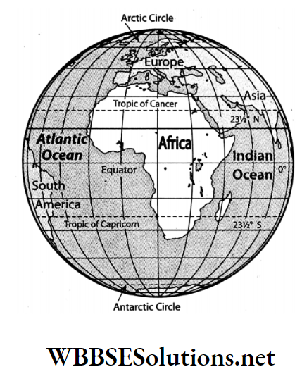
- The Equator passes halfway through Africa, whereas, the Tropic of Cancer passes through the northern part and the Tropic of Capricorn through the southern part of Africa. The Prime Meridian also passes through the western part of the continent.
- So, Africa is a unique continent with parts in the northern and southern hemispheres and also in the eastern and western hemispheres.
3. Landform:
This continent is mostly flanked by a plateau. Apart from this the northern part contains the enormous hot desert of the Sahara and the east of the continent is flanked by the Great African Rift Valley.
Read And Learn Also WBBSE Solutions For Class 7 Geography
4. Ancient plateau:
A major part of Africa is a part of the ancient Gondwanaland. Only the delta region observes the accumulation of the new alluvial soil.
5. Climate:
- As the Equator passes through the middle of Africa, the major portion of Africa receives the vertical rays of the Sun and experiences a hot summer climate throughout the year.
- The northern and southern parts of Africa remain under the influence of the Tropic of Cancer and the Tropic of Capricorn.
- So the northern and the southern part of Africa remain in the temperate zone and experience moderate climate.
6. Rivers:
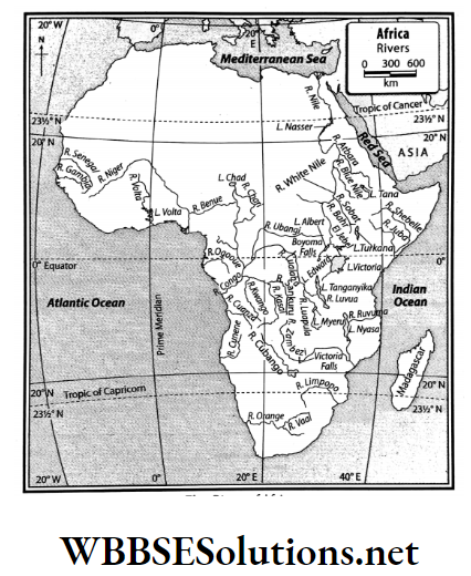
The longest river of the world, the Nile, flows through this continent. Apart from this, several other voluminous rivers such as Congo, Niger, and Zambezi also flow through Africa.
7. Mineral resources:
- Africa leads in the production of diamonds in the entire world.
- Other than this, Africa deserves a special mention for the production of mineral resources like gold, coal, mineral oil, natural gas and others.
8. Historical significance:
- One of the earliest civilizations of the world evolved from the eastern part of Africa.
- Apart from this, one of the most important nations in the history of the world Egypt is also located here.
Understanding Africa’s Natural Vegetation

Question 2. Describe the physical features of Africa.
Answer:
Physical features of Africa:
Africa is mostly a vast eroded plateau region. Based on its variation in physical features, Africa can be delineated in the following divisions-
1. North-west mountainous region:
- The Atlas Range stretches over the northwestern part of Africa. It is a fold mountain with an extension of 2500 km.
- It comprises three parallel ranges. Mt. Taubkal (4165 m) is the highest point of the Atlas Range.
2. Desert plateau region:
The northern part of Africa that was originally a part of the ancient Gondwanaland is currently a worn-out low plateau.
- The east-west extension of the desert plateau is between the Atlantic Ocean in the west to the Nile River Basin in the east.
- Two important lakes of this region are the Volta and the Chad.
- The two great plateaus of this region are the Fouta Djallon and Adamawa.
- Ahaggar Plateau and the Tibesti Plateau of Chad require a special mention.
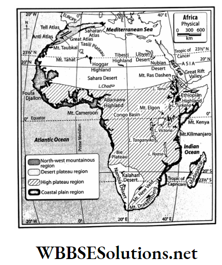
3. High plateau region:
The most noteworthy part of the eastern plateaus is marked by depressions, popularly known as the Great African Rift Valley.
- Stretching for more than 6,400 km from the Red Sea in the north to Mozambique in the south, this is the world’s longest rift valley region.
- Several lakes are found in this rift valley region that mark the source of water for the local inhabitants.
- Some important lakes of this region are Turkana, Albert, Edward, Nyasa, Tanganyika and Kivu.
4. Coastal plain region:
Coastal Africa has a few natural harbours. Along the coast lies a thin strip of coastal plain.
- This coastal plain rises to the plateau.
- Only the coastal plains near the Mediterranean Sea in the north and the Atlantic Ocean in the west are relatively broader.
- Apart from this, the delta region of Congo, Niger and Orange Rivers are also quite wide.
Question 3. Discuss the characteristic features of the rivers of Africa.
Answer:
Characteristic features of the rivers of Africa:
The characteristic features of the rivers of Africa are as follows-
1. Versatile usage:
The rivers are fast-flowing and are generally of perennial type and so, are useful for both irrigation and hydel power generation.
2. Fast-flowing and develops waterfalls:
As Africa is mostly a shield region, the rivers are generally fast-flowing. For instance, from Khartoum to the Aswan High Dam, the Nile witnesses 6 cataracts Victoria Waterfall is an example of such a waterfall that is formed on the River Zambezi.
3. Formation of large delta:
The mouths of the rivers Congo, Niger, and Orange witness large deltaic plains. Nile fans out into seven delta distributaries. The Nile Delta, the epitome of all deltas, comprises a gulf of the prehistoric Mediterranean Sea and is composed of silt, brought mainly from the Ethiopian Plateau.
4. Rivers are long but only small parts are navigable:
The rivers of Africa are long but most parts of them are not navigable. For instance, out of 6650 km of length, only 1500 km of the River Nile is navigable.
Question 4. Describe the reasons for the variation of climate in Africa.
Answer:
Reasons for variation of climate in Africa: The followings are the reasons for the variation of climate in Africa-
1. Latitudinal location:
- From north to south Africa extends from almost 38°N to 35°S and so, the Equator passes almost through the middle of Africa, diving it into two almost equal parts.
- So, Africa is a part of both hemispheres.
- When the sun’s rays fall vertically on the northern hemisphere and obliquely on the southern hemisphere, it is summer in the northern part of Africa and winter in the southern part of Africa and vice versa.
2. Distance from the sea:
- The length and breadth of Africa is spread over a vast expanse.
- For this reason, the regions that lie in the interior do not experience much influence of the sea, and deserts have developed in the northern and the central parts of the country.
- On the other hand, regions near the coast experience a much more equable type of climate.
3. Ocean current:
- The coasts of Africa that face the cold currents generally experience a cold dry climate.
- For instance, the north-western coast of Africa is influenced by the cold Canary Current and subsequently, the western part of the Sahara Desert has developed.
- Similarly, the Kalahari and Namib Deserts have developed because of the influence of the Benguela Current along the southwestern coast.
- Moreover, with the influence of the warm current of Guinea and Mozambique, Guinea and the East African coast receive heavy rainfall.
4. Altitude:
- The temperature always falls with the increasing altitude.
- This is why Mt. Kilimanjaro with a height of 5,895 m is snow-capped even if it is located in the equatorial region.
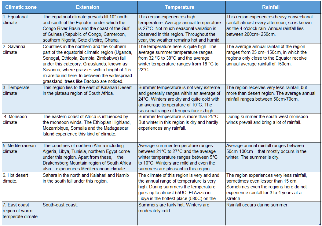
Question 5. Describe the characteristics of the various climatic zones of Africa.
Answer:
Characteristics of the various climatic zones of Africa:
The characteristics of the various climatic zones of Africa are as follows-
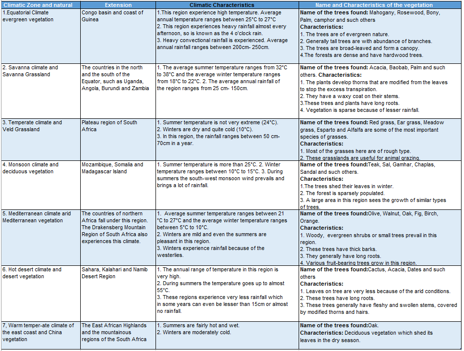
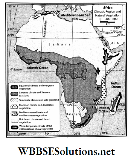
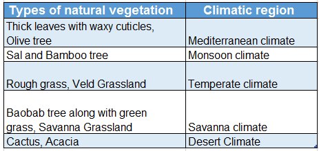
Question 6. Describe the variance in the natural vegetation due to variations in climate in Africa. Or, Mention the relationship between the climate and natural vegetation of Africa.
Answer:
Variance in the natural vegetation due to variation in climate in Africa: Variance in the natural vegetation is noticed due to variation in climate in Africa. They are as follows-
Question 7. Why is Egypt known as the ‘Gift of Nile’?
Answer:
Reasons why Egypt is known as the ‘Gift of Nile’:
The Nile flows through the Sahara Desert of northern Africa. The reasons why Egypt has been aptly called the ‘Gift of Nile’, by the Greek historian Herodotus, is discussed below-
1. Formation of floodplains:
- The average annual rainfall in Egypt is less than 25 cm. But as the source region of the Nile receives heavy rainfall, Egypt experiences floods.
- As a result, the arid regions of Egypt also get covered by silts, and agriculture becomes possible.
2. Agriculture:
- Agriculture in Egypt has become one of the main sources of livelihood.
- The major reason is the fertile silt, deposited by the Nile and the irrigation facility, that is available along the course of the river.
- As a result, high-quality cotton, wheat, banana, tobacco, millet, almond and such other crops grow here.
3. Animal rearing:
Large-scale grazing is done on the widespread grassland that stretches over the Nile Basin.
4. Transportation:
- The Nile is navigable and so, transportation facilities and trading become possible.
- The 1500 km stretch from Egypt to its mouth in the Mediterranean is navigable and this has helped trade through the waterways.
5. Generation of hydro-electricity:
The high dam on the course of the River Nile generates huge quantity of hydel power to meet the needs of industries and agriculture of Egypt.
6. Industrialisation:
The region sees the development of industries like textile, tobacco, processing of fruits, leather and such others.
Question 8. Briefly describe the geographical location of Africa.
Answer:
Geographical location of Africa:
Extending for 3,02,21,532 sq km of area, Africa is the second largest continent only after Asia
- This triangle-shaped continent is located to the south of Europe and southwest to Asia.
- Africa is bounded by the Red Sea and the Indian Ocean to its east, the Atlantic Ocean to the west, the Mediterranean Sea and the Strait of Gibraltar to the north and the confluence of the Indian Ocean and the Atlantic Ocean to the south.
Question 9. Write a short note on River Orange.
Answer:
River Orange:
- Orange (2,200 km) is one of the longest rivers in southern Africa and the fifth longest river of Africa. It rises from the Drakensberg Mountain and drains into Alexander Bay in the Atlantic Ocean.
- River Orange travels through the South African Velds.
- The Orange River Project and the Lesotho Highland Project have been planned to sustain the water demand for irrigation, urbanisation, and economic development in the central industrial areas of South Africa.
- A number of hydel power stations have been developed on this river. 29 reservoirs have been constructed on this river for irrigation.
Question 10. Write a short note on tropical grassland (Savanna).
Answer:
Tropical grassland:
The African Savanna is a tropical grassland. It covers Guinea, Sierra Leone, Liberia, Cote d’Ivoire, Ghana, Togo, Benin, Nigeria, Cameroon, Central African Republic, Chad, Sudan, Ethiopia, Somalia, the Democratic Republic of the Congo, Angola, Uganda, Rwanda, Burundi, Kenya, Tanzania, Malawi, Zambia, Zimbabwe, Mozambique, Botswana and the Republic of South Africa.
- Rainfall gradually decreases to the north and the south of the Equator. The summer season is longer and annual rainfall is around 150cm. Near the deserts, the annual rainfall decreases to about 25 cm.
- Grasses of a height of 4m-5m are found here. In between the widespread grassland trees like Baobab are noticed. The characteristics of the trees found here are-
- The plants that are found in this region, develop thorns that are modified from the leaves, to prevent the excess transpiration.
- They have a waxy coat on their stems.
- These trees and plants have long roots, that develop to collect water from deeper underground.
- Herbivorous animals like giraffes and carnivorous animals like leopards, lions, and hyenas are abundant in this region.
- Due to low rainfall, the number of tall trees is less. Instead, extensive stretches of long grasses are found.
Question 11. Write a brief note or on the Mediterranean vegetation of Africa.
Answer:
Mediterranean vegetation of Africa:
- The coastal regions along the Mediterranean Sea and its southwestern part of Africa see coverage of the Mediterranean vegetation. The summers are rainless, rainfall is prevalent during winters.
- Annual rainfall is about 5 cm-100 cm. Cork, oak, birch, olive, walnut, fig, and other plants grow in this region. This region is popular for the variety of fruits that grow here. Trees like myrtle, oleander, lavender, and rosemary are also found in this region.
The characteristics of the trees found here are-
- Woody, evergreen shrubs or small trees prevail in this region.
- These trees have thick barks.
- They generally have long roots.
- Various fruit-bearing trees grow in this region.
- The leaves of the trees are covered with a wax-like substance.
WBBSE Chapter 10 Continent Of Africa Topic A Physiography Drainage And Natural Vegetation Short Question And Answers
Question 1. Africa was known as the ‘Dark Continent’ Why?
Answer:
The reasons why Africa was known as the ‘Dark Continent’ are discussed below-
- The central part of Africa is covered with a dense forest, that is home to various fierce animals, poisonous snakes and insects.
- A major portion of Africa faces a humid and unhealthy climate or a dry arid climate.
- Several parts of Africa are still inaccessible because of lack of transportation facilities.
- Many parts of Africa are the abodes of the Aboriginals. The development of human resources is not up to the desired level till date.
- The economic and cultural development of Africa is still in a budding stage.
Question 2. Briefly describe the Atlas Mountain Range of Africa.
Answer:
The Atlas Mountain Range of Africa:
- Running from the south-west to the northeast in the north-western Africa, the Atlas Mountain Range (2000 km) forms the geologic backbone of Africa.
- This is a fold mountain that is fundamentally an isolated part of the European Alps.
- The Atlas Range is constituted of the Tell Atlas, the High Atlas, the Aures Mountains and the Saharan Atlas. Mt. Taubkal (4165 m) is the highest peak.
Question 3. Describe the desert plateau region of Africa.
Answer:
The desert plateau region of Africa:
- The northern part of Africa that was originally a part of the ancient Gondwanaland is currently a worn-out low plateau.
- This plateau gradually merges with the southern high plateau region and extends between the Atlantic Ocean in the west to the Nile River basin in the east.
- The world’s largest desert, the Sahara extends over the countries of Algeria, Chad, Egypt, Libya, Mali, Mauritania, Morocco, Niger, Tunisia and Sudan.
- The dry stony Hamada, shifting sand dunes-Aerg, and the oasis are all typical features of this desert plateau region. Two important lakes of this region are the Volta and the Chad.
Question 4. Write a brief account on the Great African Rift Valley.
Answer:
Great African Rift Valley:
- The most noteworthy part of East Africa is marked by the depressions of the plateaus, popularly known as the Great African Rift Valley.
- Stretching about 6000 km, from the Red Sea in the north to Mozambique in the south, this is the world’s longest rift valley region. Several lakes are found in this rift valley region that marks the source of water for the local inhabitants.
- A few of the most important lakes of this region are Turkana, Albert, Edward, Nyasa, Tanganyika and Kivu.
Question 5. Describe the high plateau region of Africa.
Answer:
High plateau region of Africa:
- Africa has high plateaus to its east and south. These rise approximately 1006m above sea level with a minimum rise of 610m.
- The entire country of the Republic of South Africa is a plateau, with higher elevation towards the northern border.
- South of the South African plateau, three parallel steps form the rim, each separated by a strip of level ground between them. The Great Karoo makes up the largest of these gaps between steps.
- The East African Plateau is higher than the South African Plateau. To the east, Mount Kilimanjaro stands tall, forming almost the unconquerable highest point of Africa.
- Another significant plateau region is the Ethiopian Highlands. This is Africa’s largest continuous plateau.
Question 6. Why is Africa said to be a ‘Plateau Continent’?
Answer:
- Africa is made up of raised highlands, leaving behind only a narrow strip of coastline. Africa is a part of the ancient eroded Gondwanaland. The Sahara Desert covers northern and central Africa.
- In the southern part of Sahara lies two great plateaus-Fouta Djallon and Adamawa.
- The higher region in south-east Africa is formed by the Ethiopian Highlands, a rugged mass of mountains forming the largest continuous area of its altitude in the whole continent.
- The abundance of highlands and plateaus across the continent earns Africa the nomenclature of the ‘Plateau Continent’.
Question 7. Why is the dense forest region of the Congo River Basin evergreen?
Answer:
The Congo River Basin extends up to 10° latitude on either side of the Equator. The reasons why the dense forest of this region remains evergreen are-
- The Congo River Basin experiences verticle rays of the Sun and thus the temperature remains high throughout the year.
- The volume of water of the Congo River Basin is high. It adds excessive humidity in the air, thus convectional rainfall occurs every evening.
- Due to high temperatures and excessive rainfall, dense forests remain evergreen in this region.
Question 8. What is the reason for the formation of so many rivers and lakes in Africa?
Answer:
- The East African Rift is an active continental rift zone in eastern Africa that developed almost 22 million years ago. These rifts are the outcome of the actions of numerous normal faults.
- This region experiences heavy rainfall as it is influenced by both equatorial and monsoon climates. As a result, numerous lakes like Victoria, Turkana and Albert have formed as water accumulates in the depressed regions.
- Apart from this, the excess rainfall flows down the slope to form major rivers that originate from this region. A few of the important rivers that originate from this region are Congo, Zaire, Shebelle and Jubba.
Question 9. Describe the lakes of Africa.
Answer:
lakes of Africa:
There are many lakes in Africa. These lakes can be divided into three sub-groups. They are. as follows-
1. Freshwater lakes of the mountainous regions:
- Lake Tana, Abaya, Chamo, Shala, and Langano are some of the important lakes that are found in the Ethiopian Highlands.
- Victoria, the largest lake of Africa and the second largest freshwater lake of the world, is located towards the south near the Equator.
2. Freshwater lakes of the African Rift:
Large lakes are present in the East African Rift area. They are Lake Tanganyika, Kyoga, Kivu, Malawi, Albert, Edward and such others.
3. Saltwater lakes of the deserts:
Chad Lake lies to the south of the Sahara Desert. Apart from this, there are Chottor Shott. These are the saltwater lakes in the Atlas Mountain regions.
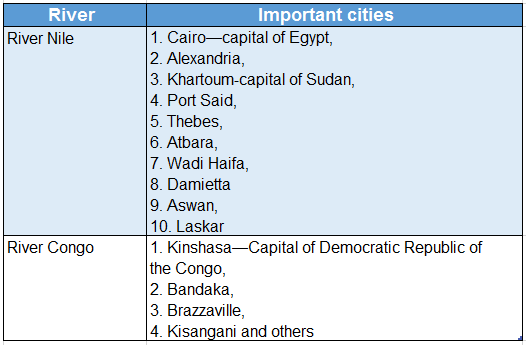
Question 10. Name the important cities on the course of the River Nile and the River Congo.
Answer:
The important cities on the course of the River Nile and the River Congo are listed below-
Question 11. Write a short note on River Congo.
Answer:
River Congo:
- Congo (formerly known as the Zaire River), the second longest river of Africa, rises in the northernmost part of Zambia and flows towards the west.
- The river originates from the wettest area of Africa.
- With a length of 4,700 km, the volume of discharge is more than the Nile. River Congo forms deep valleys in different places along its course and flows into the Atlantic Ocean.
- The entire course of the river mostly passes through the equatorial region. Along with its many tributaries, the Congo River forms the continent’s largest system of navigable waterways.
- Boyoma and Livingstone Falls have developed on the course of this river. The important cities developed on the course of this river are Kisangani, Kinshasa, Brazzaville, Bandaka, etc.
Question 12. Write a short note on River Niger.
Answer:
River Niger:
- Niger, the principal river of West Africa and the third-longest river (4180 km) of Africa, rises from Guinea Highlands.
- The river flows towards the Sahara Desert and is opposite to the Atlantic Ocean.
- The river flows northward up to Timbuktu then turns south and enters Nigeria. It forms a delta at its mouth which is highly populated.
- Cultivation and livestock rearing are major sources of livelihood here. Migratory birds flock the marshy lands of this delta every year.
Question 13. How do the latitudes influence the climate of Africa? Or, What would be the effect of latitude on the climate of Africa?
Answer:
The major portion of Africa comes under the influence of the hot torrid zone as the latitudinal extension of Africa ranges from almost 38°N to 35°S.
- As the Equator passes through the middle of Africa, the major portion of Africa receives the vertical rays of the Sun and experiences a hot summer climate throughout the year.
- The northern and southern parts of Africa remain under the influence of the Tropic of Cancer and the Tropic of Capricorn.
- So we see that the northern and southern part of Africa remain in the temperate zone and experience a moderate climate and the middle-most part of Africa remains in the torrid zone and experience hot and humid climate.
Question 14. What would be the effect of seas or oceans on the climate of coastal areas and the places away from the coasts?
Answer:
- The location of the Red Sea and the Indian Ocean to the east of Africa, the Atlantic Ocean of its west, the Mediterranean Sea to the north and the Indian Ocean to the south influences the coastal climate of Africa.
- The entire coastal region enjoys a maritime climate.
- On the other hand, the highland regions of Africa being away from the coastline experiences an extreme type of climate.
Question 15. How do ocean currents influence the climate of Africa? Or, What is the effect of ocean currents on the climate of the coastal region?
Answer:
Ocean currents influence the climate of a place, especially the coastal regions. This is also true in the case of Africa.
- The coasts of Africa that experience the flow of cold ocean currents, experience a dry climate, resulting in the formation of deserts. For example, the Sahara Desert has formed as the cold Canary Current flows along the northwest coast of Africa.
- Similarly, the Kalahari and the Namib Deserts have formed because the cold Benguela Current flows along the south- west coast of Africa.
- On the other hand, under the influence of the warm Guinea Current and the Mozambique Current, heavy rainfall is received by the Guinea coast and the east coast of Africa respectively.
As a result of the unbroken coast, the ocean current is unable to influence the interiors of Africa.
Question 16. What is the reason for the variance in temperature across Africa?
Answer:
Following are the reasons for the variance in temperature across Africa-
- Northern Africa experiences a hot summer season during the months of June and July. During this period the Sahara Desert region experiences temperatures of even upto 58°C.
- At the same time, the southern part of Africa experiences winter. So, the temperature in the Drakensberg Mountain in the south-eastern stretches of Africa falls down to 4°C.
- The months of December and January witness summer in the southern part and winter in the northern part of Africa.
- Africa experiences both summer and winter twice, as the northern part of Africa is in the northern hemisphere and the southern part is in the southern hemisphere.
Question 17. What is the reason for the variance in rainfall patterns across Africa?
Answer:
Followings are the reasons for the variance in rainfall patterns across Africa-
- The middle part of Africa lies under the equatorial region and so, experiences heavy convectional rainfall. The average annual rainfall is more than 150 cm.
- As we move away to the north and the south from the equatorial region, the amount of rainfall decreases gradually. The desert regions of Sahara and Kalahari receive an average annual rainfall of 15 cm or less.
- Few of the places here even do not receive rainfall at all for 2-3 consecutive years.
- The eastern coast of Africa receives heavy monsoon rainfall during the summer seasons.
Conceptual Questions on Desertification in Africa
Question 18. Describe the characteristics of the regions in the equatorial climate.=
Answer:
The equatorial climate is prevalent up to 10° north and south of the Equator, under which the Congo River Basin and the coast of the Gulf of Guinea fall.
The characteristic of the regions in the equatorial climate are as follows:
- Throughout the year, this region experiences high temperatures (average annual temperature is 27°C) and heavy convectional rainfall (average annual rainfall between 200 cm-250 cm).
- There is heavy rainfall almost every afternoon so, it is known as the 4 o’clock rain.
- Not much seasonal variation is observed in these regions.
- All through the year, the weather remains hot and humid-which is very uncomfortable and quite unhealthy.
Question 19. Write a note on an equatorial evergreen forest of Africa.
Answer:
Equatorial evergreen forest of Africa:
- The equatorial evergreen forest of Africa stretches from the central Congo Basin and the coast of Guinea over the countries of the Republic of Congo, Cameroon, southern Nigeria, Cote d’Ivoire, Liberia, Togo, and eastern Madagascar.
- The high temperature of about 27°C and annual rainfall of about 200 cm-250 cm is prevalent in this region.
- Ebony, Mahogany, Palm, Camphor, and such other species of trees are found here.
The characteristics of the trees found here are-
- The range of trees in the forests encompasses very tall trees to dense undergrowth.
- Trees are evergreen in nature-the leaves are green throughout the year.
- The forest sees stratified vegetation-
- The highest strata (30-45 m),
- The middle strata (13-30m) and
- The lower strata (0-15m).
- The trees are broad-leaved and form a canopy.
- The forest is almost impenetrable by sunlight.
Question 20. Describe the characteristics of the regions in the hot desert-type climate.
Answer:
The characteristics of the regions in the hot desert-type climate are as follows-
- The desert regions of the Sahara in the north of Africa and Kalahari, and Namib in the south of Africa experience very dry and extreme type of climates.
- Sand-covered or rocky landforms, cloudless sky, and dry climate of the desert region result in extremely hot days and extremely cold nights.
- The annual range of temperature is also very high.
- During summers the temperature goes up to almost 55°C.
- These regions experience very less rainfall, sometimes even lower than 25cm. Sometimes the regions in the hot desert-type climate do not experience rainfall for 3 to 4 years.
Question 21. Write a short note on the desert vegetation of Africa.
Answer:
Desert vegetation of Africa:
- The northern and the south-western dry and arid regions come under the coverage of the desert vegetation of Africa. Rainfall is almost absent over here. Day temperatures are very high and night temperatures are very low.
- Small shrubs are generally sparsely located in this region. In several regions, smaller plants like Cactus, Acacia, thorny bushes and even taller trees like dates are found around oases.
Characteristics of the trees found here are-
- Leaves on trees are very less because of the arid conditions.
- These trees have long roots and thick stems.
- These trees generally have fleshy and swollen stems, covered by modified thorns and hair.
- The regions that have underground water storage see more assemblage of trees.
- Oases can be observed in these regions.
Question 22. Write a brief note on the mountain vegetation of Africa.
Answer:
Mountain vegetation of Africa:
- The East African Highlands and the mountainous regions of South Africa witness an assemblage of softwood forests that come under the mountain vegetation of Africa.
- Pine, Fir, and such other trees are found here. This vegetation mostly comes under the coniferous type of forest and certain other portions of the forest come under the temperate deciduous type of forest.
The characteristics of the trees found here are-
- Mostly coniferous trees grow here and in certain regions, grasslands are also found because of the presence of a cool climate.
- The trees are mostly cone-shaped.
- The vegetation comprises softwood trees.
Question 23. Discuss the reasons for the development of dense forests in the Congo River Basin.
Answer:
- The Congo River flows through the equatorial climatic region and so, receives vertical sun rays all through the year. As a result. all around the year, the river basin experiences only a hot humid summer season.
- The average temperature generally varies between 25°C – 27°C. Apart from this, these regions also receive daily afternoon rainfall that generally amounts to 200 cm-250 cm or more annually.
- This creates an ideal scenario for the growth of dense vegetation. So, an assemblage of dense, stratified evergreen. the forest is seen in the Congo River Basin.
Question 24. Briefly describe the monsoon deciduous forests of Africa.
Answer:
The monsoon deciduous forests of Africa:
In eastern Africa, the coasts of Mozambique, Tanzania, Kenya, and Somalia are covered by monsoon deciduous forests. The regions with less rainfall see an assemblage of Teak, Sal, Gamhar, Chaplas, Sandals,s and others. On the other hand, in the regions with more rainfall, trees like Rosewood, Mahogany, Ironwood, Neem, Bamboo, and Cane are found. The monsoon deciduous forests of Africa show the following characteristic-
- The trees shed their leaves in the winter.
- The wood from these trees is used for making furniture.
- The forest is not very dense but relatively sparse.
- Large coverage of forest sees similar types of trees.
- The forest is easily penetrable as there is very less or no undergrowth.
Question 25. List the variance in the natural vegetation due to variations in climate in Africa.
Answer:
Due to variances in climate, an evident variation in the natural vegetation can be noticed everywhere, and Africa is not an exception.
Question 26. Describe the location of the important latitudes and longitudes of Africa.
Answer:
- The Equator passes halfway through Africa and the Prime Meridian passes through the western part of Africa.
- From west to east Africa extends from 17°33’W to 51°24’E longitude and from north to south it extends from 37°20’N to 34°52’S.
- Even the Tropic of Cancer and the Tropic of Capricorn both pass through Africa.
Question 27. Why has the rift valley formed in East Africa?
Answer:
- Due to tectonic movements, faults have formed on the surface in East Africa. The land between the two faults has subsided to form a rift valley.
- A number of lakes have been formed in the rift valley region. These lakes are large and deep.
Question 28. What are the physiographic divisions of Africa?
Answer:
Physiographic divisions of Africa:
Though the major portion of Africa comes under a residual plateau region, but still Africa can be divided into four physiographic divisions. They are as follows-
- North-west mountainous region,
- Desert plateau region,
- High plateau region and
- Coastal plain region.
Question 29. Write about the coastal plain region of Africa.
Answer:
Coastal plain region of Africa:
- Coastal Africa is very even with few natural harbors. Along the coast, there is a thin strip of coastal plain. This rapidly rises to the plateau.
- Only the coastal plains near the Mediterranean Sea in the north and the Atlantic Ocean in the west are relatively broader. Apart from this, the delta regions of Congo, Niger, and Orange Rivers are also quite wide.
Question 30. Describe the course of River Zambezi.
Answer:
The course of River Zambezi:
- Zambezi (2574 km) is the fourth longest river of Africa. The river originates in the Central African Plateau and flows eastwards into the Indian Ocean.
- On its course, it crosses the boundaries of six countries-Angola, Zambia, Namibia, Botswana, Zimbabwe Mozambique. Victoria and Chavuma are important falls that develop on the course of River Zambezi.
- Two major hydel power stations have also been built upon this river.
Real-Life Scenarios Involving Ecosystems in Africa
Question 31. What is 4 ‘o’clock rain?
Answer:
4 ‘o’clock rain:
- The Congo River Basin and the banks of the Gulf of Guinea near the Equator receives very heavy convectional rainfall. A main characteristic of this convectional rainfall is that, it occurs almost every day in the afternoon at around 4 o’clock.
- This is the reason why this rainfall is known as the 4 o’clock rain.
Question 32. Why is it winter in the south of Africa when it is summer in the north of Africa? Or, Why is the climate not similar at same time of the year in the northern and the southern part of Africa?
Answer:
- From north to south, Africa extends from almost 38°N to 35°S and so, the Equator passes almost through the middle of Africa, dividing it into two almost equal parts. So, Africa is a part of both hemispheres.
- When the sun rays fall vertically on the northern hemisphere and obliquely on the southern hemisphere, it is summer in the northern part of Africa and winter in the southern part of Africa and vice versa.
Question 33. Why is the peak of Mt. Kilimanjaro permanently snow-clad in spite of being situated in the equatorial region?
Answer:
- Though Africa is mostly part of the torrid zone, but the southeastern part of Africa falls under a cooler temperate climate, mostly because of the altitude.
- We know, that the normal lapse rate is 6.5°C. per 1000 m. So, Mount Kilimanjaro (5895 m) remains snow-capped all through the year.
Question 34. Why is the weather in central Africa different from the weather in the northern and southern parts at the same time?
Answer:
- The Equator passes halfway through Africa, whereas the Tropic of Cancer passes through the northern part and the Tropic of Capricorn through its southern part.
- Thus the central part of Africa experiences vertical sun rays and falls under the torrid zone. On the other hand, the northern and southern parts of Africa come under the temperate zones.
Question 35. Write about the influence of the ocean on the climate of Africa.
Answer:
The influence of the ocean on the climate of Africa:
- Africa is bounded by the Red Sea and the Indian Ocean to its east, the Atlantic Ocean to the west, the Mediterranean Sea and the Strait of Gibraltar to the north, and the confluence of the Indian Ocean and the Atlantic Ocean to the south.
- So, an equable climate is experienced in the coastal regions of Africa. However, the influence of the oceans gradually decreases to the interiors and thus extreme types of climate can be observed in interiors.
Question 36. Name the various climatic zones of Africa.
Answer:
Africa can be delineated into seven climatic zones based on the diversity in the weather conditions ranging from temperature, rainfall, air pressure and wind currents. They are-
- Region of equatorial climate,
- Region of savanna climate,
- Region of monsoon climate,
- Region of hot desert-type climate,
- Region of temperate climate,
- Region of Mediterranean climate and
- The eastern coastal region of warm temperate climate
Question 37. Briefly describe the temperate grassland or Veld.
Answer:
The temperate grassland or Veld:
- The temperate grassland or Veld spreads over the plateau region of South Africa. Red Alfalfa are some of the most important species of grass, Ear grass, Meadow grass, Esparto, and of grasses.
- Trees like Poplar and Willow grow above the hill slopes. Plains are covered with small and rough grasses. The winter temperature of this region is low, the summers are moderate and the seasonal range of temperature is high.
- The amount of rainfall is more than the desert region.
Question 38. Write any three characteristics of the Veld.
Answer:
Three characteristics of the Veld:
The temperate grassland or Veld spreads over the plateau region of South Africa. The followings are some important characteristics of the Veld-
- The climate of the Veld is rather variable. It experiences a high seasonal range of temperature due to its location away from the coast.
- Most of the grasses (like Ear grass, Meadow grass, Esparto, and Alfalfa) here are small and rough. Thus, this region is used for animal gazing.
WBBSE Chapter 10 Continent Of Africa Topic A Physiography Drainage And Natural Vegetation Very Short Question And Answers
Question 1. Name the second-largest continent of the world.
Answer: Africa.
Question 2. Which sea divides Africa from Asia?
Answer: Red Sea.
Question 3. Name the strait that separates Africa from Europe.
Answer: Strait of Gibraltar.
Question 4. What was Africa earlier called due to its inaccessibility?
Answer: Dark Continent.
Question 5. Name the sea situated to the north of Africa.
Answer: Mediterranean Sea.
Question 6. Name the gulf situated to the west of Africa.
Answer: Gulf of Guinea.
Question 7. Name the mountain range that runs across the northwest stretch of Africa.
Answer: Atlas Mountains.
Question 8. Which is the highest peak in High Atlas?
Answer: Mount Taubkal.
Question 9. Name the lake to the south of the Sahara Desert.
Answer: Chad Lake.
Question 10. Name the largest fault region in the world.
Answer: Great African Rift Valley.
Question 11. Name the highest peak in Africa.
Answer: Mount Kilimanjaro.
Question 12. What are the salt lakes, located between the Tell Atlas and the Saharan Atlas, known as?
Answer: Chott or, Shott.
Question 13. Name a significant island near Africa.
Answer: Madagascar.
Question 14. Name an important lake of the Great Rift Valley region.
Answer: Lake Tanganyika.
Question 15. Name two deserts of South Africa.
Answer: Kalahari Desert and Namib Desert.
Question 16. Name the largest island in the continent of Africa.
Answer: Madagascar.
Question 17. What is the length of the longest river of Africa?
Answer: River Nile-6650 km.
Question 18. Name the largest city on the bank of the River Congo.
Answer: Kinshasa.
Question 19. Which peninsula connects Africa to Asia?
Answer: Sinai.
Question 20. Name an important river that flows through the southwestern part of the Sahara Desert.
Answer: River Niger.
Question 21. Name the dam that is constructed on the Zambezi River Basin between Zambia and Zimbabwe.
Answer: Kariba Dam.
Question 22. Name the second-longest river of Africa.
Answer: River Congo.
Question 23. Name the river that flows through the Veld grassland in Africa.
Answer: River Orange.
Question 24. Which is the largest freshwater lake in Africa?
Answer: Lake Victoria.
Question 25. Name the fifth-longest river of South Africa.
Answer: River Orange.
Question 26. Which river of Africa is known as the Oil River?
Answer: River Niger.
Question 27. Name two countries that are located on the bank of the Mediterranean Sea.
Answer: Libya and Algeria.
Question 28. Which part of Africa witnesses the low-lying landform covered with grassland interrupted by rift valleys and scattered lakes?
Answer: Eastern part of Africa.
Question 29. Which forest showcases stratified growth of trees along with baboon and chimpanzee-like animals?
Answer: Equatorial rainforest.
Question 30. Name the tropical grassland of Africa.
Answer: Savanna.
Question 31. Where in Africa can lions and zebra be seen?
Answer: Savanna Grassland
WBBSE Chapter 10 Continent Of Africa Topic A Physiography Drainage And Natural Vegetation Fill In The Blanks
Question 1. Africa is the world’s _________ largest continent.
Answer: Second
Question 2. Suez Canal and the _________ divide Africa from Asia.
Answer: Red Sea
Question 3. _________ Canal divides Africa from Asia.
Answer: Suez
Question 4. Africa is bounded by _________ Ocean to its west.
Answer: Atlantic
Question 5. Africa is connected to Asia by the landbridge called _________ Peninsula.
Answer: Sinai
Question 6. The continent of Africa is _________shaped.
Answer: Triangle
Question 7. The Strait of _________ is located in northern Africa.
Answer: Gibraltar
Question 8. The highest peak of Atlas Mountain is _________.
Answer: Mt. Taubkal
Question 9. The Strait of _________ separates Africa from Europe.
Answer: Gibraltar
Question 10. _________ is the highest peak of Africa.
Answer: Mt. Kilimanjaro
Question 11. _________ mountain is a range across the northwestern stretch of Africa.
Answer: Atlas
Question 12. The hot desert located in the southern part of Africa is known as _________.
Answer: Kalahari
Question 13. _________ is the longest river of the world.
Answer: Nile
Question 14. Namib is a coastal desert in the _________ part of Africa.
Answer: Southern
Question 15. The second oldest freshwater lake of the world, _________ is located in the continent of Africa.
Answer: Tanganyika
Question 16. _________ is the main mountain range of the eastern part of Southern Africa.
Answer: Drakensberg
Question 17. The Ahaggar Mountains are located amidst of _________.
Answer: Sahara
Question 18. The port of Alexandria is a _________ port.
Answer: Sea
Question 19. The largest island in the continent of Africa is the _________.
Answer: Madagascar
Question 20. The _________ Waterfall is located on the course of River Zambezi.
Answer: Victoria
Question 21. River _________ of Africa forms a large delta at its mouth.
Answer: Nile
Question 22. River _________ is the main river of the western Africa.
Answer: Niger
Question 23. The Zambezi river has its mouth in the _________ Ocean.
Answer: Indian
Question 24. Cap _________ is located to the south of Madagascar.
Answer: St. Mary
Question 25. Cape Town of South Africa experiences _________ type of climate.
Answer: Mediterranean
Question 26. The _________ delta region of Nile experiences _________ climate.
Answer: Mediterranean
Question 27. The _________ River Basin of Africa experiences an equatorial type of climate.
Answer: Congo
Question 28. Sunlight hardly penetrates to the forest- floor of the _________.
Answer: Equatorial
Question 29. Alfalfa grass grows in the _________ grassland of South Africa.
Answer: Veld
Question 30. The regions with a Mediterranean type of climate experience rainfall in the _________ season.
Answer: Winter
Question 31. _________ trees grow in the continental desert region of Africa.
Answer: Date Palm
Question 32. Chlorophyll is found in the _________ leafless vegetation of the hot desert regions.
Answer: Stems
Question 33. Grapes: Mediterranean climate:: Cactus: _______.
Answer: Desert climate
Question 34. River Congo: West flowing:: _______: East flowing.
Answer: River Zambezi
Question 35. Tropical grassland: Savanna:: Temperate grassland: _______.
Answer: Veld
WBBSE Chapter 10 Continent Of Africa Topic A Physiography Drainage And Natural Vegetation True Or False
Question 1. Mount Kilimanjaro is snow-capped even though it is situated in the equatorial region.
Answer: True
Question 2. The continent of Africa experiences both summer and winter twice a year.
Answer: True
Question 3. The middle portion of Africa comes under the influence of the sub-tropical high-pressure zone, whereas the northern and southern parts come under the influence of the equatorial low-pressure zone.
Answer: False
Question 4. The northeast trade winds blow over the northern parts of Africa.
Answer: True
Question 5. The temperate grassland of Veld is situated in central Africa.
Answer: False
Question 6. The Mediterranean Sea is located in the southern part of the continent of Africa.
Answer: False
Question 7. The temperature of the equatorial climatic region is very low.
Answer: False
Question 8. Monsoon climate can be observed in the northern parts of Africa.
Answer: False
Question 9. The trees of the Mediterranean forest have small and thick leaves with waxy cuticles.
Answer: True
Question 10. Congo is the only river in Africa that crosses the Equator twice during its course.
Answer: True
Question 11. The Strait of Gibraltar is located to the north-western part of Africa.
Answer: True
Question 12. The Persian Gulf separates Africa from Asia.
Answer: False
Question 13. The Drakensberg Mountain Range lies in the south of Africa.
Answer: True
Question 14. The baobab tree can be mostly seen in the Savanna grassland area.
Answer: True
Question 15. Most region of Africa falls under the torrid zone.
Answer: True
Question 16. The Atlas Mountain Range lies to the south of the Sahara Desert.
Answer: False
Question 17. The grassland to the north of Africa is known as the Veld.
Answer: False
Question 18. The hydel power project on Victoria Waterfall is located in Cameroon.
Answer: False
Question 19. One of the most important examples of a navigable river of Africa is River Orange.
Answer: False
Question 20. River Volga flows through the continent of Africa.
Answer: False
Question 21. Victoria Waterfall is formed on the course of River Orange.
Answer: False
WBBSE Chapter 10 Continent Of Africa Topic A Physiography Drainage And Natural Vegetation Match The Columns
1.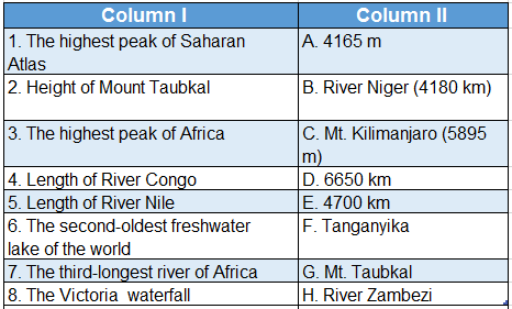
Answer: 1. G, 2. A, 3. C, 4. E, 5. D, 6. F, 7. B, 8. H
2. 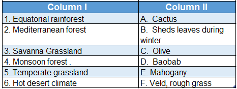
Answer: 1. E, 2. C, 3. D, 4. B, 5. F, 6. A