WBBSE Chapter 1 Topic B Apparent Annual Motion Of The Sun And Effects Of The Earths Revolution Long Question And Answers
Question 1. What are the reasons for the season change? Or, How is the setting in of different seasons affected by the varying lengths of days and night and the difference of the Sun’s angle of incidence?
Answer:
Reasons for season change:
The reasons behind the cycle of seasons are as follows-
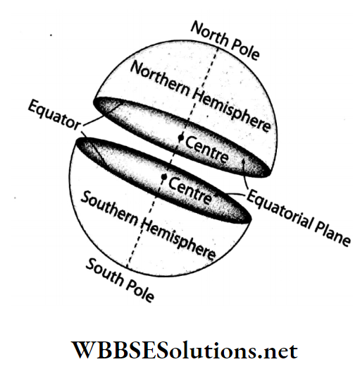
1. Geoid shape of the Earth:
Due to the geoid shape of the Earth, the angle of incidence of the Sun’s rays is not equal all over the Earth. Thus, there is a difference of surface temperature.
2. Varying lengths of days and nights:
The hemisphere that experiences the vertical rays of the Sun, has longer days and shorter nights.
- The heat received during these longer days is more and all of it is not radiated back during the short night span.
- Thus, some of the retained heat increases the temperature of the surface and those places experience summer.
- Likewise, when the nights are longer and the days are shorter, the entire heat is lost during the long nights.
- Thus, the region becomes cold and experiences winter.
WBBSE Solutions For Class 7 Geography
3. Difference in the heat received due to the difference in the incidence of sunrays:
During a revolution, the region which remains inclined towards the Sun receives more sunlight. Therefore this region experiences summer and the other regions experience winter, spring and autumn.
4. Elliptical orbit of the Earth:
Since the orbit of the Earth is elliptical, the distance between the Sun and the Earth varies. This varying distance gives rise to the difference in the heat received and the experience of seasons.

Question 2. Describe the different seasons or cycles of seasons that prevail over the Earth.
Answer:
Different seasons that prevail over the Earth:
There are four seasons-
- Spring,
- Summer,
- Autumn and
- Winter.
1. Spring:
On 21 March the Earth reaches such a position with respect to the Sun that-
- The sun rays fall vertically on the equator,
- Days and nights are equal all over the earth on that day,
- The sun remains equidistant from both poles,
- At every place on the earth, the sun rises and sets at 6 a.m. And 6 p.m. Respectively. The northern hemisphere has sprung for a period of 1 month before and 12 months after 21 March. The southern hemisphere has autumn at that time.
2. Summer:
After 21 March, the Earth slowly moves towards such a position that the sun’s rays gradually begin to fall vertically over the northern hemisphere. On 21 June the Earth reaches such a position on its orbit with respect to the Sun that-
- The sun rays fall vertically on the tropic of cancer,
- The north pole remains completely inclined towards the sun,
- The south pole remains completely away from the sun,
- The northern hemisphere has longer days and shorter nights. The northern hemisphere experiences summer for a period of 1½ months before and 1½ months after 21 June. The southern hemisphere experiences winter at that time.
3. Autumn:
On 23 September the Earth reaches such a position on its orbit that-
- The sun rays fall vertically on the Equator due to which days and nights become equal on every place over the Earth,
- Like 21 March, this day is also called Equinox. The northern hemisphere has autumn for a period of 1½ months before and 12 months after 23 September. The southern hemisphere has spring at that time.
4. Winter:
On 22 December the Earth reaches such a position that-
- The sun rays fall vertically on the Tropic of Capricorn,
- The North Pole remains completely away from the Sun,
- The northern hemisphere has shorter days and longer nights. Winter prevails in the northern hemisphere for a period of 1½ months before and 1½ months after 22 December. The southern hemisphere has summer at that time.
Question 3. Draw a diagram to explain the occurrence of the summer season in the northern hemisphere.
Answer:
A diagram to explain the occurrence of the summer season in the northern hemisphere:
Occurrence of the summer season in the northern hemisphere:
- After 21 March, the Earth gradually comes to such a position concerning,
- The Sun that sunlight begins to fall vertically on the northern hemisphere.
- As a result, the length of days increases while that of nights decreases.
- This indicates the apparent movement of the Sun towards the north.

On 21 June the Sun and the Earth lie at such a position concerning each other that-
- The sun rays fall vertically on the Tropic of Cancer,
- The North Pole remains completely inclined towards the Sun,
- The northern hemisphere experiences the longest day (14 hours) and the shortest night (10 hours).
- So the temperature increases and the summer season prevails.
- This season continues over a period of 1½ months before and 1½ months after 21 June.
- At this time the Sun can be seen at the North Pole for 24 hours. On the other hand, the South Pole experiences 24 hours of darkness.
- Thus the northern hemisphere has summer while the southern hemisphere has winter.
Question 4. Describe the position of the Earth and the Sun from 23 September to 22 December and its effect.
Answer:
The position of the Earth and the Sun from 23 September to 22 December and its effects: The effects of the Earth-Sun position from 23 September – 22 December are as follows-
1. Autumnal Equinox:
- On 23 September both the hemispheres of the Earth lie at an equal distance from the Sun.
- he sun rays fall vertically on the Equator and the length of the day and night is equal all over the Earth.
- The northern hemisphere experiences autumn and thus it is known as the autumnal equinox.

2. Commencement of winter in the northern hemisphere and summer in the southern hemisphere:
- From after 23 September, the Earth is positioned on its orbit in such a way that the southern hemisphere receives vertical rays of the Sun.
- Thus, the days are longer and nights are shorter in the southern hemisphere.
- Due to the southward march of the Sun, there is the commencement of winter in the northern hemisphere and summer in the southern hemisphere.
3. Winter Solstice:
- On 22 December the Earth is positioned on its orbit in such a way that vertical sun rays fall on the Tropic of Capricorn (23½° S). On this day the southern hemisphere experiences the longest day and shortest night.
- During this time there is 24 hours of sunlight in the South Pole and 24 hours of darkness in the North Pole. This day is known as the winter solstice.
Question 5. Discuss the effects of revolution.
Answer:
Effects of revolution:
The revolution of the Earth causes various changes on the Earth’s surface.
These are as follows-
1. Varying lengths of day and night:
- As the Earth’s axis always remains inclined at an angle of 66½° towards the orbital plane, the lengths of days and nights on the Earth’s surface vary.
- It has been observed that- On 21 June days are longer and nights are shorter in the northern hemisphere. On 21 March and 23 September days and nights are of equal duration.
- These days are called equinoxes. On 22 December the southern hemisphere experiences shorter days and longer nights.
2. Change of seasons:
- The variation in the lengths of days and nights leads to differences in temperature and this causes changes of seasons.
- So we can experience four seasons all over the Earth-summer, autumn, winter and spring. Opposite conditions prevail in the two hemispheres.
3. Determining year and leap year:
- The Earth revolves around the Sun once in 365 days 5 hours 48 minutes 46 seconds. This constitutes 1 year.
- Again one whole day is added to every fourth year which has 366 days with 29 days in the month of February. This is called a leap year.
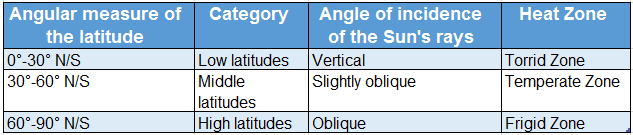
4. Creation of heat zones:
- The sun rays fall at different angles at different places on the Earth at different times of the year.
- The Earth is divided into three heat zones based on the angle at which the sunrays fall.
These are-
- Torrid Zone
- Temperate Zone
- Frigid Zone.
Question 6. What are the various ways to prove the Earth’s revolution?
Answer:
Ways to prove the Earth’s revolution:
Some ways to prove that the Earth is in a state of constant revolution are as follows-
1. Observation of stars:
- If we observe a particular group of stars in a particular part of the night sky for a few days, then we will find that they keep shifting towards the west.
- After a few days, they disappear and new stars appear in their place. After one year, the first set of stars appears again. This happens because of the revolution.
2. Apparent movement of the Sun:
- On 21 March and 23 September, the Sun rises in the due east and sets in the due west.
- On other days it rises and sets a little towards the north or the south.
- If the Earth would have rotated at the same place then sunrise and sunset would have taken place at the same place every day.
3. Gravitational Force theory:
The Sun is 13 lakh times larger and 34 million times heavier than the Earth. So, according to the Gravitational Force theory, the Earth revolves around the Sun.

4. Revolution of other planets:
- It has been observed through powerful telescopes that other planets in the solar system revolve around the Sun.
- So the Earth, being a planet, cannot be an exception.
5. Direct proof:
The photographs taken from space through the satellites also show that the Earth exhibits revolutionary movement.
Question 7. What do you mean by the apparent daily movement of the Sun?
Answer:
Daily movement of the Sun:
Every day we see the sun rises in the east and set in the west. It seems as if the Earth is still while the Sun is moving around it.
- This movement, showing the change in the position of the Sun with respect to the stars as seen from the Earth is called the apparent daily movement of the Sun or its apparent diurnal motion.
- The term apparent is used because the Earth actually to the Tropic of Cancer and this movement is known to revolve around the Sun. as the apparent northward movement of the Sun.

Question 8. What is Vernal Equinox?
Answer:
Vernal Equinox:
Vernal Equinox in the northern hemisphere refers to the day on which vertical sunrays fall over the Earth’s Equator at midday.

- It falls on 21 March every year. On this day, every place on the Earth’s surface experiences equal hours of day and night (i.e. 12 hours of the day and 12 hours of the night).
- Since it marks the end of winter and the beginning of spring in the northern hemisphere, the day is also called Spring Equinox.
Question 9. What is Summer Solstice?
Answer:
Summer Solstice:
According to the apparent movement of the Sun, the Tropic of Cancer or 23½° N marks as the ultimate limit of the Sun’s movement towards the north.
- This movement ends on 21 June. This day is referred to as Summer Solstice.
- On this day, the sun rays fall vertically over the Tropic of Cancer at noon.
- The northern hemisphere experiences the longest day (14 hours) and shortest night (10 hours) and the southern hemisphere experiences the opposite-shortest day and longest night.

Question 10. What do you mean by Midnight Sun and the Land of the Midnight Sun? Or, Why can the Sun be seen at midnight from Hammerfest Port in Norway?
Answer:
The tilted axis of the Earth and its movement around the Sun results in six months of continuous daylight (21 March – 23 September) at the North Pole and its surrounding areas.

During this time, from the northern extent of Port Hammerfest in Norway (70½° N, 24°E) the Sun (May-July) can be seen near the horizon even at night according to local time.
This is known as Midnight Sun and the country is known as the ‘Land of the Midnight Sun’.
Question 11. What is Winter Solstice?
Answer:
Winter Solstice:
According to the apparent movement of the Sun, the Tropic of Capricorn or 23%1⁄2°S marks as the ultimate limit of the Sun’s movement towards the south.
- This movement ends on 22 December. This day is referred to as Winter Solstice.
- On this day the sun rays fall vertically over the Tropic of Capricorn at noon.
- The southern hemisphere experiences the longest day (14 hours) and shortest nights (10 hours).
- The northern hemisphere experiences the opposite -the shortest day and the longest night.

Question 12. What is meant by the apparent path of the Sun?
Answer:
The apparent path of the Sun:
We all know that the Earth moves around the Sun but it seems as if the Sun is moving around the Earth from east to west.
- This path is fixed and is termed the apparent annual movement of the Sun.
- The revolution of the Earth around the Sun results in the apparent annual movement of the Sun.
- The Sun apparently moves northwards from 22 December to 21 June and southwards from 21 June to 22 December.

Question 13. Fill up the knowledge hive with information about Summer Solstice.

Answers:
1. On 21 June the sunrays fall vertically on the Tropic of Cancer (23½°).
2. The northern hemisphere leans more towards the Sun.
3. The area from the Arctic Circle to the North Pole receives 24 hours of daylight for a period of 6 months around this time.
4. The area from the Antarctic Circle to the South Pole has 24 hours of darkness for a period of 6 months around this time.
5. The northern hemisphere experiences the longest day and shortest night.
6. The southern hemisphere experiences the shortest day and longest night.
Question 14.

Answers:
1. 23 September
2. 22 December
3. 21 March
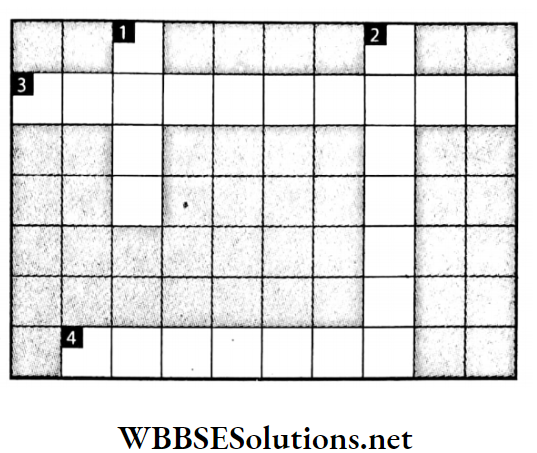
Question 15.

Down:
2. This is the season after winter.
3. 0° latitude.
4. This season is known as fall and marks the transition from summer to winter.
Across:
1. February has 29 days in this year
Answers:
Down: 2. SPRING, 3. EQUATOR, 4. AUTUMN
Across: 1. LEAP YEAR
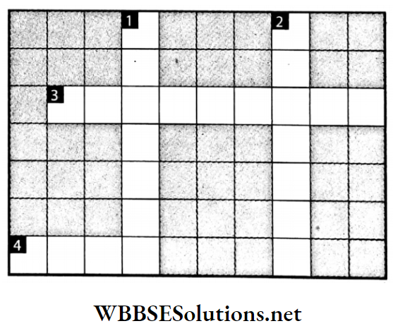
Question 16.

Down:
1. A star at the centre of the solar system.
3. It contains within itself all the planets, stars, intergalactic matter, etc.
Across:
2. This motion of the Earth is the reason behind the occurrence of seasons.
4. This motion of the Earth causes day and night.
Answers:
Down: 1. SUN, 3. UNIVERSE
Across: 2. REVOLUTION, 4. ROTATION
Question 17.

Up-Down:
2. The position when the Earth is furthest away from the Sun on its orbit.
3. Equal days and equal nights.
4. Our galaxy.
Across:
1. The eighth planet.
5. The shape of the Earth’s orbit.
6. The dramatic play of light in the night sky near the Poles.
7. 23½° N latitude is the Tropic of ________.
Answers :
Up-Down: 2. APHELION, 3. EQUINOX. 4. MILKY WAY
Across: 1. NEPTUNE, 5. ELLIPTICAL, 6. AURORA, 7. CANCER
Question 18. Why is the heat received at the lower latitudes more than that at the higher latitudes?
Answer:
- At the lower latitudes, sunrays fall vertically over the Earth’s surface producing more heat. At the equator (0°) it is summer throughout the year.
- As one moves away from the Equator, sunrays become slanting. This leads to a decrease in average heat received on the Earth’s surface.

Question 19. Every object light or heavy falls downwards, isn’t it? Which direction is downwards?

Answer:
According to the picture, all four of them will say that the ball is falling downwards, be it from the bottom, from the sides, from the top, i.e., from all sides.
Question 20. In the following diagram, mark the positions of the Earth, the date of positions and the distance from the Sun.

Answer:
- Perihelion,
- Aphelion,
- January,
- July,
- 14 crore 70 lakh km,
- 15 crore 20 lakh km
Question 21. Examine the perpendicular and oblique rays with the help of a torch.
Answer:
- The light of a torch is cast on a table or the floor in a dark room. First, the torch is held 1-2 feet above the table. How big is the circular lit area formed on the table? And how bright is it? It looks like a circle of brightly lit areas has formed on the table or on the floor.
- Now the torch is kept at the same height and held slightly tilted. Does it make the size of the lit circular area bigger and brighter? It is seen that the light is spreading in more places.
- However, the light is much less intense than when it was held vertically. This test gives an idea of why the heat is gradually decreasing towards the two Poles of the Earth.
Examples of Real-Life Applications of Solar Positioning

Question 22. Make a Sun Dial.
Answer:
The steps to build a sundial are as follows-
- At first, a white paper on a plain surface is placed.
- Then a long stick is placed in the middle of the white paper.
- Next, on a sunny day, the shadow of the stick on the paper from sunrise to sunset is marked with a pencil.
- Last, the time of the shadow lines are noted down. In this manner, a sundial showing accurate time can be made.
- It can be seen that a time clock has been made on the white paper. This is where any time of the day can be determined by looking at the shadow of the stick. In this way, a useful sundial is prepared.

Question 23. Draw an ellipse with the help of a pencil, two pins and a small thread.
Answer:
- Ellipses can be drawn with the help of a pencil, pin and thread. The two ends of the thread are tied together and knotted to make a loop.
- Two pins on cardboard are stuck according to the picture. Now the loop of the thread is placed on the cardboard in such a way that the loop surrounds the two pins.
- Then a pencil is put inside the loop, the loop is kept tight and turned on the cardboard to draw a circle. It will not be exactly round, it will be an elongated circle. The name of this circle is an ellipse.
- 39 Many more ellipses can be drawn by sticking the two pins near or far apart. Some will be oval-shaped and some will be very flat. However, it can be seen when two pins are very closely stuck, the shape will be almost round.

WBBSE Chapter 1 Topic B Apparent Annual Motion Of The Sun And Effects Of The Earths Short Question And Answers
Question 1. What do you mean by the apparent annual movement of the Sun?
Answer:
Annual movement of the Sun
- If we look carefully at the positions of the sunrise and sunset throughout the year, we will notice that except on 21 March and 23 September, the sun rises a little more towards the north or south of due east.
- The same thing happens with sunset. Since the sun’s rays fall vertically on the tropics at different times of the year, it seems as if the Sun moves between the Tropic of Cancer and the Tropic of Capricorn (23½° N-23½° S) throughout the year.
- This change in the position of the Sun as seen from the Earth is termed as Sun’s apparent annual movement.
Question 2. Write about the Sun’s apparent northward movement.
Answer:
Sun’s apparent northward movement:
- The change in the position of the Sun with respect to the stars as seen from the Earth is known as the Sun’s apparent movement.
- This motion of the Sun is restricted between the Tropic of Cancer (23½°North) and the Tropic of Capricorn (23½° South).
- From December till 21 June, the Sun apparently moves from the Tropic of Capricorn to the Tropic of Cancer and this movement is known as the apparent northward movement of the sun.
Question 3. Write about the Sun’s apparent southward movement.
Answer:
Sun’s apparent southward movement:
- The change in the position of the Sun with respect to the stars as seen from the Earth is known as the Sun’s apparent movement.
- This motion is restricted between the Tropic of Cancer (23½° N) and the Tropic of Capricorn (23½°S).
- After 21 June till 22 December, the Sun apparently moves from the Tropic of Cancer to the Tropic of Capricorn.
- This movement is known as the apparent southward movement of the Sun.
Short Answers on Seasonal Changes and Sun’s Position
Question 4. Why is it winter in the northern hemisphere, when it is summer in the southern hemisphere?
Answer:
- Due to the tilt of the Earth after 23 September, the southern hemisphere moves towards the Sun while the northern hemisphere moves away from the Sun.
- As a result of this apparent movement, vertical rays of the Sun fall over the area in the southern hemisphere and it experiences summer while the northern hemisphere experiences winter
Question 5. What is Autumnal Equinox?
Answer:
Autumnal Equinox:
- Autumnal Equinox refers to the day on which vertical sun rays fall on the Earth’s Equator at midday. It falls on 23 September every year.
- On this day, every place on the Earth’s surface experiences equal hours of day and night (12 hours of day and 12 hours of night).
- Since it marks the beginning of autumn in the northern hemisphere it is called the Autumnal or Fall Equinox.
Question 6. Write a short note on Solstice.
Answer:
Solstice:
- Solstice refers to either of the two days of a year when the Sun is at the farthest point from the Equator.
- The summer solstice in the northern hemisphere is on 21 June, when the sunrays fall directly over the Tropic of Cancer.
- The winter solstice is on 22 December, when the sunrays fall directly over the Tropic of Capricorn. The word ‘solstice’ is derived from the Latin words ‘sol’ (Sun) and ‘sister’ (to stand still).
- The day of the solstice is either the longest day of the year (in summer) or the shortest day of the year (in winter) for any place on the tropics.
Question 7. Differentiate between Summer Solstice and Winter Solstice.
Answer:
The differences between Summer Solstice and Winter Solstice are as follows-

Question 8. How does summer set in the northern hemisphere?
Answer:
Due to the Earth’s axial tilt (66½°) with the orbital plane from 21 March the northern hemisphere becomes more inclined towards the Sun.
- During this time, sunrays fall vertically over the northern hemisphere leading to an increase in the length of the day and an average temperature of the Earth.
- This period is termed as summer in the northern hemisphere.
- At the same time, the opposite happens in the southern hemisphere.
Question 9. How does autumn occur in the northern hemisphere?
Answer:
After 21 June, there is a gradual inclination of the South Pole towards the Sun and of the North Pole away from the Sun.
- On 23 September, sunrays fall vertically on the Equator leading to equal lengths of day and night.
- The insolation received by the Earth’s surface during the day is radiated back to space at night as a result we experience moderate temperatures.
- The period of one and half months before and after 23 September is known as autumn in the northern hemisphere. In the southern hemisphere, it is spring during this period.
Conceptual Questions on Equinoxes and Solstices
Question 10. How does winter set in the northern hemisphere?
Answer:
After 23 September the North Pole moves away from the Sun and sunrays fall obliquely over the northern hemisphere.
- During this time days are shorter than the nights in the northern hemisphere and the surface of the Earth of this hemisphere gets less heated.
- Longer nights mean that the solar insolation received during the days is completely radiated back to space and a sharp dip in the temperature is felt.
- This period of one and a half months before and after 22 December, is known as winter.
Question 11. When is it spring in the northern hemisphere and autumn in the southern hemisphere?
Answer:
On 21 March, the Earth reaches a position on its orbit at which both the Poles are equidistant from the Sun.
- Sun’s rays fall vertically over the Equator leading to equal lengths of day and night.
- At this time, the solar insolation received during the day is completely radiated back to space and moderate temperature prevails.
- This period is called spring in the northern hemisphere and autumn in the southern hemisphere.
Question 12. How does summer set in the southern hemisphere?
Answer:
After 23 September, the South Pole gradually begins to incline towards the Sun and more than half of the southern hemisphere receives direct sun rays.
- As a result of this, days are longer than nights in this hemisphere.
- The solar insolation received during the day does not completely radiate back to space.
- This leads to a gradual increase in the average surface temperature of the areas of the southern hemisphere.
- This period of one and half months before and after 22 December, is summer in the southern hemisphere.
Question 13. Why do the people living in the southern hemisphere celebrate Christmas during summer?
Answer:
Christmas in the southern hemisphere is celebrated at the same time as the rest of the world i.e. 25 December.
- On 22 December, sunrays fall vertically over the Tropic of Capricorn (23½° S) in the southern hemisphere.
- For this reason, from November to January, it is summer in the southern hemisphere.
- Since 25 December falls within this period people living in the southern hemisphere celebrate Christmas during summer.
Question 14. What is meant by illuminated night?
Answer:
Illuminated night:
Sunrays fall slantingly on the Arctic and Antarctic Circles throughout the year.
- From 22 March to 21 June, the Sun does not rise above the horizon or set below in the northern hemisphere.
- It remains at a position parallel to the horizon i.e. for 24 hours the Sun can be seen in the sky.
- Since it can be seen in the sky even at night, the night seems to be illuminated.
Question 15. Why do polar regions experience continuous daylight for six months and continuous night-time for the next six months?
Answer:
The Earth is tilted at an angle of 66½° towards its orbital plane and rotates around at that angle. As it orbits the Sun, the northern.
- The hemisphere that is tilted towards the Sun receives more sunlight than the other hemisphere.
- The poles are at the extreme ends and therefore, have extreme periods of Sun exposure i.e. when the North Pole experiences six months of daylight, darkness prevails at the South Pole (21 March – 23 September) and vice versa (23 September – 21 March).
Question 16. Write a brief note on Aurora Borealis and Aurora Australis.
Answer:
Aurora Borealis and Aurora Australis:
An ‘aurora’ is a natural light display in the sky, particularly in the high latitudes i.e. in the Arctic and the Antarctic regions.
- When the polar regions experience six months of continuous night-time (23 September-21 March in the northern hemisphere and 21 March – 23 September in the southern hemisphere) spectacular glowing lights can be seen in the sky caused due to the collision of ionised gas present in the atmosphere and sun rays.
- In the northern hemisphere, it is known as Aurora Borealis or Northern Lights and in the southern hemisphere it is known as Aurora Australis or Southern Lights.

Question 17. Throughout the year, there is no seasonal change in the equatorial and polar regions. Why?
Answer:
Throughout the year, sunrays fall vertically over the Equator (0°) and the summer season persists in the equatorial region (equal lengths of days and nights).
- Since there is no change in temperature there is no seasonal change as well in the equatorial region.
- Whereas, the polar regions experience six months of daylight and six months of night-time as a result of which the surface never gets heated in excess and winter is prevalent.
Question 18. If the axis of the Earth was in the same plane with its orbit, (as seen in Uranus) what would have happened to the natural cycle of days, nights and seasons in such cases?
Answer:
Effects, if the axis of the Earth would have been on the same plane as the orbit-
Effect on the natural cycle of days and nights:
- There would have been no variation in the lengths of days and nights.
- The sunlight would have been incident on one-half of the Earth equally throughout the year.
- The lengths of days and nights would have been equal both in summers and winters.
- The two Poles wouldn’t have experienced 6 prolonged months of day and night.
Effect on seasons:
- Seasons wouldn’t have changed.
- The equatorial region would have changed into the cold polar region and the polar regions would have changed into the hot dry equatorial region.
Question 19. Tabulate the increase/decrease in the length of day and night as the year progresses.
Answer:
The increase/decrease in the length of day and night as the year progresses is tabulated below-
| Vertical Sunrays |
Length of Day and Night |
|
| Date |
Name of the day |
Latitude |
Sun angle |
Northern Hemisphere |
Southern Hemisphere |
| Day |
Night |
Day |
Night |
| 21-Jun |
Summer Solstice |
23½°N |
90° |
14 hours |
10 hours |
10 hours |
14 hours |
| 23 September |
Autumnal Equinox |
0° |
90° |
12 hours |
12 hours |
12 hours |
12 hours |
| 22 December |
Winter Solstice |
23½° S |
90° |
10 hours |
14 hours |
14 hours |
10 hours |
| 21 March |
Vernal Equinox |
0° |
90° |
12 hours |
12 hours |
12 hours |
12 hours |
Question 20. At what local time does the Sunset in New York, Delhi and Cairo on 23 September?
Answer:
- 23 September is the day of the Autumnal Equinox when the Sun shines vertically on the Equator and all places on the Earth experience equal hours of day and night, i.e. 12 hours each.
- Thus, at 6:00 pm according to respective local times, the Sun will set in New York, Delhi and Cairo.
Question 21. How is the cycle of seasons caused?
Answer:
The cycle of seasons caused:
- The cycle of seasons is caused by the inclination of the Earth’s axis.
- It is the transitional change of the four seasons i.e. summer, spring, autumn and winter at different places on the Earth’s surface.

Given below is a table showing the cycle of seasons:

Question 22. What are the reasons behind the variation in the lengths of day and night?
Answer:
The variation observed in the lengths of day and night is mainly due to-
- Earth’s revolution
- The tilt of the Earth’s axis makes an angle of 66½° with the orbital plane.
- Geoid shape of the Earth
- Earth’s rotation
- The elliptical shape of the Earth’s orbit
- The fixed position of the tilted axis of the Earth (in the direction of the Pole Star) etc.
Question 23. How do seasons Influence human life?
Answer:
Seasons Influence human life:
Human life is greatly affected by the occurrence of seasons. Seasons play an important role in every sphere of our daily life.
For the definition of time for agricultural practices and other occupations, clothes we wear, and festivals we celebrate. Everything is season-oriented. Apart from these, even animals have a fixed time for laying eggs and giving birth to offspring. Seasonal variations also affect our moods.
Question 24. Write a brief not on the season and seasonal change.
Answer:
- The Sun is the only source of energy and heat on the Earth’s surface.
- The Earth’s surface gets heated by the insolation coming from the Sun but due to the tilt of the Earth’s axis
- Every part on its surface does not get an equal amount of sunrays throughout the year.
- This division of the year marked by changes in weather, ecology and hours of daylight is known as season.
- The transitional period between two seasons is known as seasonal change.
Question 25. Carefully observe the position of the sunrise in the sky on the 1st and 2nd day of each month. Mark these positions with a straight line in the direction.
Answer:
The position of the sunrise in the sky in different of the month is tabulated below-

Question 26. Prepare a list and write down the time of sunrise and sunset on any particular day each week in the month of June. Repeat this exercise in December.
Answer:
Time of sunrise and sunset in a different month of the year is tabulated below-

Question 27. In summer you have a long time to play after school. But winter, dusk sets in earlier. Why?
Answer:
- In winter dusk sets earlier because the hemisphere that experiences winter is away from the Sun.
- Thus, it receives slanting rays of the Sun resulting in shorter days (approximately 10 hours) and longer nights (approximately 14 hours).
Question 28. Why do we feel hot during summer? Or, Why is summer hotter than winter?
Answer:
- During summer, the Sun’s rays hit the Earth at a steep angle. The light does not spread out much leading to an increase in the amount of energy received at the surface.
- Also, during summer the length of the day is much longer. The long daylight hours give the Earth’s atmosphere plenty of time to get heated and we feel hot.
Question 29. Why do we feel cold during winter?
Answer:
During winter, the Sun’s rays hit the Earth at a shallow angle.
- These rays spread out on the surface minimising the amount of energy received at any particular point.
- Also, the long nights and shorter days prevent the Earth from warming up and therefore, we feel cold.
Question 30. Choose the correct reason for the following-
The Sun’s apparent annual motion, changes in day and night, and season change.
- Elliptical Orbit of the Earth
- Earth’s inclined axis
- Rotation and revolution.
(1,2/2,3/1,3/1,2,3)
Answer: 1,2,3-all the options are correct.
Question 31. Is Christmas Day truly a long day?
Answer:
- Christmas Day is on 25 December, 3 days after Winter Solstice. During this time, the southern hemisphere experiences summer with shorter nights and longer days.
- The opposite condition prevails in the north. Thus, Christmas Day is never truly a longer day in the Northern Hemisphere.
Question 32. Had the axis of the Earth been perpendicular to its orbital plane (as seen in Jupiter) what would have happened to the natural cycle of days, nights and seasons in such a case?
Answer:
Effects if the axis of the Earth is perpendicular to the orbital plane-
- There would have been no variation in the lengths of days and nights.
- There wouldn’t have been 6 prolonged months of days and nights at the Poles.
- There wouldn’t have been any season change on Earth.
Question 33. What is the length of the day at 0° latitude when it is daytime in North Pole (six months of day)?
Answer:
The Earth’s axis is tilted on the orbital plane at an angle of 66 and its centre coincides with that of the Circle of Illumination due to which places on the 0° latitude experience equal hours of day and night (i.e. 12 hours of day and night) throughout the year.
Question 34. Why is there no seasonal change in the equatorial region?
Answer:
Our Earth makes an angle of 66% with the orbital plane and the centre of the Earth coincides with that of the Circle of Illumination.
- Throughout the year, during midday sunrays fall vertically over the areas near the Equator resulting in equal lengths of day and night (12 hours of day and 12 hours of night).
- Since the amount of sunlight received at the surface does not change there is no seasonal change.
Question 35. What is the local time of sunrise in Tokyo, Kolkata and Sydney on 21 March?
Answer:
- On 21 March, the Sun will rise at 6 ‘o’clock in the morning in Tokyo, Kolkata and Sydney.
- As 21 March is the day of the Vernal Equinox, each and every place on the Earth’s surface experiences the Sunrise at the same time on this day.
Real-Life Scenarios Involving Daylight Variation
Question 36. When is the local time of sunrise on 4 July, 25 January and 20 September at any place on the Equator?
Answer:
Places on the equatorial line experience equal day and night throughout the year. So every day the sun rises at 6 ‘o’clock at places on the Equator.
Question 37. Each and every place on the Earth’s surface experiences equal hours of day and night on 21 March and 23 September. Why?
Answer:
- During the revolution around the Sun, on 21 March and 23 September, the Earth reaches a point on its orbit which is perpendicular to the position of the Sun.
- The Sun rises at 6 am and sets at 6 pm as per local time in all places resulting in equal length of day and night on the Earth’s surface.
Question 38. Have you seen, reverse seasons in the Northern and Southern Hemispheres?
Answer:
| Special Day |
Northern Hemisphere |
Seasonal flowers, fruits and festivals |
Southern Hemisphere |
| 21 March |
Equal day-night |
Spring |
Olive, Palash, Holi |
Equal day-night |
Autumn |
| 21 June |
Longest day |
Summer |
Rajnigandha, Mango, New year, Charak Mela |
Shortest day |
Winter |
| 23 September |
Equal day-night |
Autumn |
Shiuli, Kash, Custard apple, Durga Puja |
Equal day-night |
Spring |
| 22 December |
Shortest |
Winter |
Sunflower, Orange, X-mas |
Longest day |
Summer |
Question 39. When does the sun rise over the equinoctial line on 25 August?
Answer:
- On 25 August, the sun rises at 6 a.m. over the equinoctial line. Throughout the year, sunrays fall vertically on the equinoctial or equatorial line.
- As a result of this, any place situated on this line experiences equal hours of day and night (12 hours of day and 12 hours of night).
Question 40. Why do scientists visit Antarctica in December?
Answer:
- Antarctica is the Earth’s southernmost continent and is always covered in snow.
- During December it is summer in the southern hemisphere and with an increase in the surface temperature, many parts become frost-free.
- For this reason, scientists prefer to undertake Antarctic expeditions in December.
Question 41. Briefly explain the Relation between the celestial bodies with respect to the Law of Gravitation.
Answer:
Relation between the celestial bodies with respect to the Law of Gravitation:
- According to the Law of Gravitation, lighter objects move around the heavier ones. Since the Earth’s mass is less than that of the Sun, the former moves around the latter.
- Similarly, the satellites move around the planets as they are lighter.
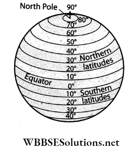
Question 42. Why is there a gradual decrease in surface temperature from the Equator to the Poles? Or, As we move towards the north or south from the Equator, a distinct change in the intensity of the sun’s rays is observed. Why is it so?
Answer:
As the Earth is in the form of a sphere, the angle of incidence of the sun’s rays at the Earth’s surface decreases from the Equator towards the Poles and therefore the amount of heat received over a given area decreases in the same direction.
Surface temperature is normally highest near the Equator and lowest at the Poles. However, there is a seasonal variation of temperature owing to the annual changes in the Sun’s declination between 23½° N and 23½° S.
Question 43. What would have happened if the Earth had rotated in the north-south direction?
Answer:
The following would have happened if the Earth rotated in the north-south direction-
- If the Earth had rotated in the north-south direction then day and night would not have occurred as at present.
- The Sun would have risen from the north and set in the south.
- The polar regions would have experienced 12 hours of the day and 12 hours of the night throughout the year.
- Sunrays would have fallen vertically on the central meridian of the Earth.
WBBSE Chapter 1 Topic B Apparent Annual Motion Of The Sun And Effects Of The Earths Very Short Question And Answers
Question 1. What is the apparent path followed by the Sun while moving from east to west in the sky called?
Answer: Sun Path.
Question 2. What is the apparent seasonal and hourly positional changes of the Sun known as?
Answer: Sun’s Ecliptic.
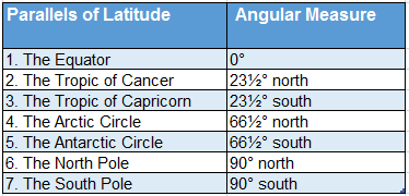
Question 3. What is the limit of the Sun’s apparent northward movement?
Answer: Tropic of Cancer (23½° N).
Question 4. What is the limit of the Sun’s apparent southward movement?
Answer: Tropic of Capricorn (23½° S).
Question 5. On which day in March does every place on the Earth’s surface have 12 hours of day and night?
Answer: Vernal Equinox (21 March).
Question 6. On which day in September does every place on the Earth’s surface have 12 hours of day and night?
Answer: Autumnal Equinox (23 September).
Question 7. On which day does the Tropic of Cancer receive vertical sun rays?
Answer: Summer Solstice (21 June).
Question 8. What is the longest day in the northern hemisphere and shortest day in the southern hemisphere called?
Answer: Summer Solstice
Question 9. On which day does the Tropic of Capricorn receive vertical sun rays?
Answer: Winter Solstice (22 December).
Question 10. What is the shortest day in the northern hemisphere called?
Answer: Winter Solstice (22 December).
Question 11. Which direction does the Sun apparently move towards from 22 December to 21 June?
Answer: North.
Question 12. In which region do we observe six months of daylight at a stretch?
Answer: Polar regions.
Question 13. Which direction does the Sun apparently move towards in between 21 June and 22 December?
Answer: South.
Question 14. What is the name of the Polar Lights seen in the Polar skies at night?
Answer: Aurora Borealis in the North Pole and Aurora Australis in the South Pole.
Question 15. Name a port in Norway from which the midnight Sun can be seen.
Answer: Hammerfest.
Question 16. In which seasons do we have a clear sky on most of days?
Answer: Spring and autumn.
Question 17. Name the season in which the Earth is parched.
Answer: Summer.
Question 18. Name the season in which ponds are full of water.
Answer: Monsoon.
Question 19. Name the season in which floods are likely.
Answer: Monsoon and autumn.
Question 20. Name the season in which you can actually fish in shallows and canals.
Answer: Summer and winter.
Question 21. In which season does the location of sunrise shift the most southward in the sky?
Answer: Winter.
Question 22. In which season is the shadow at 12 noon found to be the longest compared to the rest of the year?
Answer: Winter.
Question 23. What is the name of the season when you hear the Cuckoo calling?
Answer: Spring
Question 24. In which season is the day longest in the northern hemisphere?
Answer: Summer.
Question 25. Does the southern hemisphere feel warm or cold on 25 December?
Answer: Warm.
Question 26. When do we come closer to Sun, July or January?
Answer: January.
Question 27. When is the shadow of the pole the smallest? (Morning/Noon/Afternoon)
Answer: Noon.
Question 28. When does the shadow become the tallest? (Morning/Noon/Afternoon)
Answer: Morning and afternoon.
Question 29. The shadow in a sundial! In your sundial measure the length of the shadow at 12 noon on 21 March, 21 June and 22 December.
1. On which days is the length of the shadow the smallest?
2. On which day is it the longest?
Answer:
- The smallest shadow is on 21 June.
- The tallest shadow is on 22 December.
WBBSE Chapter 1 Topic B Apparent Annual Motion Of The Sun And Effects Of The Earths Fill In The Blanks
Question 1. When it is summer in the northern hemisphere, the southern hemisphere experiences _____________.
Answer: Winter
Question 2. The apparent annual motion of the Sun is termed _____________.
Answer: Sun’s Ecliptic
Question 3. _____________ Onwards sunrays fall perpendicularly over the northern hemisphere.
Answer: 21 March
Question 4. When the northern hemisphere experiences winter, it is _____________ in the southern hemisphere.
Answer: Summer
Question 5 When the northern hemisphere experiences spring, it is _____________ in the southern hemisphere.
Answer: Autumn
Question 6. The limit of the Sun’s apparent northward movement is _____________.
Answer: Tropic of Cancer
Question 7. The limit of the Sun’s apparent southward movement is _____________.
Answer: Tropic of Capricorn
Question 8. Throughout the year, _____________ season prevails in the polar regions.
Answer: Winter
Question 9. _____________ region experiences equal lengths of day and night throughout the year.
Answer: Equatorial
Question 10. Winter Solstice is on _____________.
Answer: 22 December
Question 11. During winter, Sun’s rays fall _____________ on the northern hemisphere.
Answer: Slantingly
Question 12. In the northern hemisphere, Summer Solstice is on _____________.
Answer: 21 June
Question 13. 21 March is also known as _____________.
Answer: Vernal Equinox
Question 14. Vernal Equinox is also known as _____________ Equinox.
Answer: Spring
Question 15. _____________ is on 23 September.
Answer: Autumnal Equinox
Question 16. _____________ season follows the winter season and precedes the summer season.
Answer: Spring
Question 17. _____________ is also termed as ‘fall’ in North America.
Answer: Autumn
Question 18. Summer is the only season in the _____________ region.
Answer: Equatorial
Question 19. Winter is the dominant season in the _____________ regions.
Answer: Polar
Question 20. The longest day in the northern hemisphere is on _____________.
Answer: 21 June
Question 21. The longest day in the southern hemisphere is on _____________.
Answer: 22 December
Question 22. The shortest day in the northern hemisphere is on _____________.
Answer: 22 December
Question 23. The shortest day in the southern hemisphere is on _____________.
Answer: 21 June
Question 24. A gradual decrease in the length of the day is observed in the _____________ hemisphere after 22 December.
Answer: Southern
Question 25. The north polar region experiences 24 hours of night from _____________ to _____________month.
Answer: September, January
Question 26. The north polar region experiences 24 hours of day from _____________ to _____________ month.
Answer: March, June
Question 27. The south polar region experiences 24 hours of day from _____________ to _____________ month.
Answer: September, December
Question 28. The south polar region experiences 24 hours of night from _____________ to _____________month.
Answer: March, June
Question 29. In the southern hemisphere, Christmas is celebrated during _____________.
Answer: Summer
Question 30. In the northern hemisphere, Christmas is celebrated during _____________.
Answer: Winter
Question 31. The Northern Lights are also known as _____________.
Answer: Aurora Borealis
Question 32. The Southern Lights are also known as _____________.
Answer: Aurora Australis
Question 33. In the northern hemisphere, the Sun can be seen at midnight from _____________ port of _____________.
Answer: Hammerfest, Norway
Question 34. Seasonal changes occur due to the Earth’s _____________.
Answer: Tilted axis
Question 35. The periodic change from winter to summer is known as _____________.
Answer: Cycle of seasons
Question 36. In India the season before summer is called _____________.
Answer: Spring
Question 37. In India, the end of summer is called _____________.
Answer: Monsoon
Question 38. In the northern hemisphere, _____________ season prevails from the first week of August to that of November.
Answer: Autumn
Question 39. In India, _____________ sets in with the end of winter season.
Answer: Spring
Question 40. In the northern hemisphere, _____________ season prevails from the last week of November to the mid-week of February.
Answer: Winter
Question 41. During _____________ leaves change colour and fall from the trees.
Answer: Autumn
Question 42. In India, the season before winter is called _____________.
Answer: Autumn
Question 43. During winter, days are _____________ in length.
Answer: Shorter
Question 44. In the month of _____________ Scientists undertake voyages to Antarctica.
Answer: December
Question 45. Vernal Equinox: ____________:: Autumnal Equinox: 23 September.
Answer: 21 March
Question 46. Aurora Borealis North Pole: : ____________: South Pole.
Answer: Aurora Australis
WBBSE Chapter 1 Topic B Apparent Annual Motion Of The Sun And Effects Of The Earths True Or False
Question 1. Polar regions have continuous 6 months of day and 6 months of night.
Answer: True
Question 2. 23½° N latitude is the limit of the Sun’s apparent northward movement.
Answer: True
Question 3. 23½° S latitude is the Tropic of Capricorn.
Answer: True
Question 4. Seasonal changes are not observed in equatorial regions.
Answer: True
Question 5. Polar regions experience 6 months of winter and 6 months of summer.
Answer: False
Question 6. Australia is known as ‘the Land of the Midnight Sun’.
Answer: False
Question 7. Equatorial regions experience equal day and night hours throughout the year.
Answer: True
Question 8. In the North Pole, from 21 March to 23 September Northern Lights or Aurora Borealis can be seen.
Answer: False
Question 9. In the northern hemisphere, sunrays fall vertically on the Earth’s surface up to the Arctic Circle.
Answer: False
Question 10. In the southern hemisphere, sunrays fall vertically on the Earth’s surface up to the Tropic of Capricorn.
Answer: True
Question 11. During autumn and spring, the length of day and night becomes equal.
Answer: False
Question 12. From the Poles towards the Equator sunrays gradually become slanted or oblique.
Answer: False
Question 13. The word ‘Equinox’ means equal day and night.
Answer: True
Question 14. On 21 June days and nights are equal in all parts of the Earth’s surface.
Answer: False
WBBSE Chapter 1 Topic B Apparent Annual Motion Of The Sun And Effects Of The Earths Find The Odd One Out
Question 1. Sun Earth Moon: life
Answer: Life (not a celestial body)
Question 2. North Pole South Pole centre of Earth: Tropic of Cancer
Answer: Tropic of Cancer (not an imaginary point)
Question 3. Month: hour minute: second
Answer: Month (not a unit of time)
Question 4. 1996 2004 2007: 2012
Answer: 2007 (not a leap year)
Question 5. 21 March 21 April: 21 June: 23 September
Answer: 21 April (not a date of Equinox or Solstice)
Question 6. India: Norway: Alaska: Sweden
Answer: India (not a country experiencing Northern Lights)
WBBSE Chapter 1 Topic B Apparent Annual Motion Of The Sun And Effects Of The Earths Correct The Following
Question 1. The Sun is 13 times larger than the Earth.
Answer: 13 lakh
Question 2. The imaginary line on which the Earth rotates is called an orbit.
Answer: Axis
Question 3 The orbit of the Earth is circular.
Answer: Elliptical
Question 4. The Sun lies at the centre of the ellipse.
Answer: Focus
Question 5. 4 July is called Perihelion.
Answer: Aphelion
Question 6. A year with 365 days is called a leap year.
Answer: 366
Question 1. On 21 June, sunrays fall vertically on me. Who am I?
Answer: Tropic of Cancer
Question 2. In the sky above me midnight Sun can be observed. I am in Norway. Who am I?
Answer: Hammerfest Port
Question 3. People who live within my boundaries have to wear woollen clothes throughout the year. Which region am I?
Answer: Polar region
Question 4. I am a place on Earth where the Sun rises at 6 in the morning and where there is 12 hours of the day and 12 hours of the night throughout the year. Who am I?
Answer: Equatorial region
Question 5. I was the one who first stated that the Earth and the other planets revolve around the Sun. Who am I?
Answer: Copernicus
Question 6. I stay at the focus of the elliptic orbital path. Who am I?
Answer: Sun
Question 7. I am the only satellite of the Earth. Who am I?
Answer: Moon
Question 8. Due to me all the celestial bodies move along specific paths in space. Who am I?
Answer: Gravitational force
Question 9. We were the ones who first put forward the idea of leap year. Who are we?
Answer: Egyptians
Question 10. I illuminate the northern polar region during the six months of night time. Who am I?
Answer: Aurora Borealis or Northern Lights
WBBSE Chapter 1 Topic B Apparent Annual Motion Of The Sun And Effects Of The Earths Scrambled Words
1 CALLIPELTI
2 LOCAPETYVEESCI
3 ONAPLI HE
4 THNARMONLU
5 YESOLARAR
6 ARAPLEYE
7 MERICESOLSUMST
8 UINOXEQ
Answers:
1. ELLIPTICAL
2. ESCAPE VELOCITY
3. APHELION
4. LUNAR MONTH
5. SOLAR YEAR
6. LEAP YEAR
7. SUMMER SOLSTICE
8. EQUINOX
WBBSE Chapter 1 Topic B Apparent Annual Motion Of The Sun And Effects Of The Earths Match The Columns
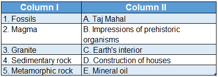
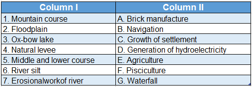
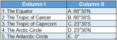
Question 1.
Answer: 1. B, 2. A, 3. D, 4. C, 5. E
Question 2. 
Answer: 1. A, 2. C, 3. B, 4. E, 5. D