Chapter 5 India-Physical Environment Topic 3 Water Resources Of India Long Answer Type Questions
Question 1. Describe the courses of the three major rivers of northern India.
Answer:
The three major rivers of northern India are—the Ganga, Indus, and Brahmaputra.
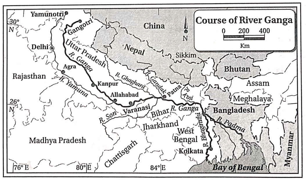
1. The Ganga: The total length of the river Ganga is 2525 km, of which 2017 km lies in India. This is the most important river in India. The course of the Ganga can be divided into three parts—
1. Upper Course: The river Ganga rises from the Gomukh cave of the Gangotri glacier in the Garhwal Himalayas. Here the river is known as the river Bhagirathi. The river Alaknanda meets the river Bhagirathi at Devaprayag, and the combined flow is known as the river Ganga. The stretch of the river from its source up to Haridwar is known as its upper course.
2. Middle course: The middle course of the river Ganga stretches from Haridwar to the Rajmahal hills. The right bank tributaries Yamuna and Son and the left bank tributaries Gomti, Ghaghara, Ramganga, Gandak, Kosi, etc. meet the river Ganga in this course and multiply both its load and volume of water. The most important tributary of the river Ganga is the river, Yamuna.
3. Lower course: The lower course of the river Ganga extends from south of Rajmahal hills to the mouth in the Bay of Bengal. The Ganga after entering West Bengal bifurcates into two branches near Dhulian of Murshidabad. One of the branches enters Bangladesh as Padma and later drains into the Bay of Bengal as the river Meghna.
Read and Learn Also WBBSE Solutions for Class 10 Geography and Environment
The other branch flows through West Bengal as the Bhagirathi-Hooghly river before meeting the Bay of Bengal. The right bank tributaries in this course are—Ajay, Damodar, Kangsabati, and Rupnarayan. The left bank’s tributaries are— Jalangi,
Mathabhanga, Churni, etc. The river Ganga together with the river Brahmaputra forms the largest delta in the world.
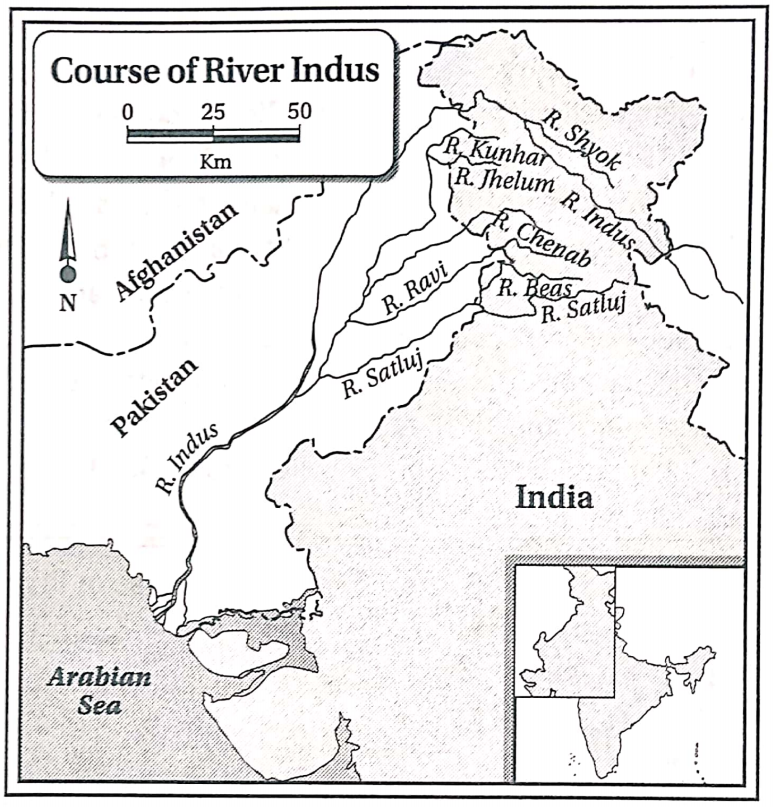
2. The Indus: The Indus is the longest and the most important river in northwestern India. It stretches for 2900 km, of which 1114 km lies in India. It rises from the Senge Khabab glacier near the Manas Sarovar in the Greater Himalayas. It flows through Jammu and Kashmir and then turns southwards near Nanga Parbat, entering Pakistan. From there it flows southwards and meets the Arabian Sea (southeast of Karachi).
The most important left-bank tributaries of the river Indus are— Jhelum, Chenab, Ravi, Beas, and Sutlej. These tributaries flow over Jammu and Kashmir, Himachal Pradesh, and Punjab. The right bank tributaries are— Shyok, Gilgit, Shigar, etc. The river Indus forms deep gorges near the Nanga Parbat massif. It forms a small delta at its mouth.
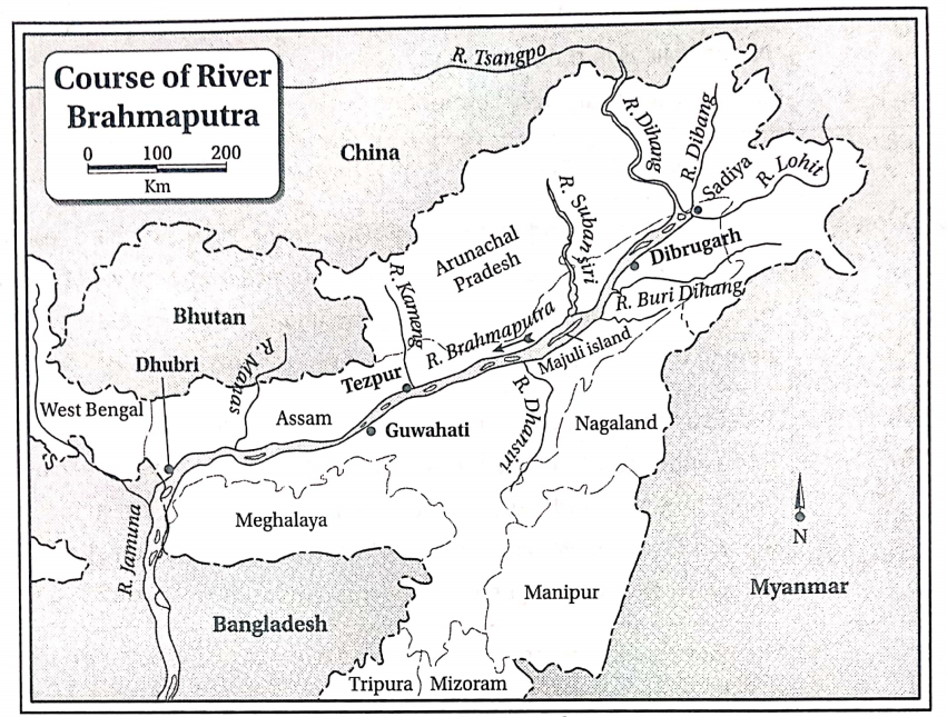
3. The Brahmaputra: The river Brahmaputra is the most important river in north-eastern India. It flows for 2900 km, of which 916 km lies in India. The river rises from the Chemayungdung glacier in Tibet. Here it flows as river Tsangpo over the Tibetan plateau for about 1500 km.
Near the Namcha Barwa peak, it takes a sharp turn towards the southwest and enters Arunachal Pradesh as river Dihang. The Dihang meets the rivers Dibang and Lohit near Sadiya in Assam. The combined flow of these three rivers flows as the river Brahmaputra westwards over Assam till Dhubri.
From Dhubri it turns southwards and enters Bangladesh as the river Jamuna. It meets the river Padma near Goalondo and enters the Bay of Bengal. The course of the river Brahmaputra in Assam is highly braided, forming several islands. The island of Majuli near Jorhat in Assam is the largest riverine island in India.
Some important right-bank tributaries of the river Brahmaputra are— Subansiri, Kameng or Jiya Bharali, Manas, and Sankosh. Some left-bank tributaries of the river Brahmaputra are- Dhansiri, Kopili, and Buri Dihing.
“WBBSE Class 10 Geography Chapter 5 Water Resources notes”
Question 2. Compare the characteristic features of the rivers of North and South India.
Answer:
The comparison of the characteristic features of the rivers of North and South India are as follows—
| Point of comparison |
North Indian rivers |
South Indian rivers |
| Nature of flow |
The rivers of North India are both rainfed and snow-fed. Hence, they are perennial. |
These rivers are mostly rainfed. They tend to dry up in the dry season. Hence, they are non-perennial. |
| Course of rivers |
The rivers exhibit their upper, middle, and lower courses prominently. |
The rivers do not exhibit the upper, middle, and lower courses prominently. In many cases, these three courses are not at all present. |
| Nature of the course |
Most of the rivers tend to deviate from their original courses in the lower stretch. Hence, oxbow lakes and meanders are formed. |
Most of the rivers flow through hard rocky regions. They do not change their courses. Hence, meanders and oxbow lakes are absent. |
| Valleys |
They form deep V-shaped and 1-shaped valleys in their upper courses. Gorges are very common. |
They form very few deep valleys. |
| Length |
These rivers are very long. |
These rivers are comparatively short. |
| Silt deposition |
These rivers erode and bring down huge volumes of detritus materials from the mountains and deposit them in their lower courses. |
These rivers flow over hard resistant rock surfaces. Hence, the level of erosion is low, and so results in a lesser amount of silt deposition. |
| Hydel power generation |
Hydel power can be generated only in the upper course of the rivers, where they flow with great speed. The middle and lower courses are not suitable for power generation. |
The rivers have formed numerous waterfalls flowing over the plateau region. Hence, they are suitable for hydel power generation almost throughout their courses. |
| Irrigation |
The rivers being perennial are suitable for irrigation throughout the year. |
The rivers can be used for irrigation only if water is stored behind dams. |
| Navigability |
The rivers are perennial. The middle and lower courses are navigable as they have a very gentle slope. |
The rivers are non-perennial. They flow over rugged terrain. Hence, they are not navigable. |
| Tributaries and distributaries |
The rivers flow for a very long distance and have numerous tributaries. The lower courses of the rivers are divided into several distributaries due to the deposition of silt in the channel. |
The rivers flow through the plateau region and have fewer tributaries. The number of distributaries is fewer as well because the amount of silt deposition is less. |
| Delta |
The North Indian rivers deposit huge quantities of silt at their mouths and hence form large deltas. |
The South Indian rivers deposit small quantities of silt at their mouths and hence form small and narrow deltas. In some cases, the rivers do not form deltas at all. |
Question 3 Give a short description of the main rivers of India
Answer:
The main river of India and their different features are listed below-
| River |
Length |
Source |
Mouth |
States/UTs covered |
Tributaries |
Main cities on banks |
| Ganga |
5525 km of which 2517 km is India. |
Gomukh cave of the Gangotri glacier. |
Bay of Bengal |
Uttarakhand, Uttar Pradesh, Bihar, West Bengal |
Left bank: Ghaghara, Kosi Ramganga, Gandak Right bank: Yamuna, Son |
Haridwar, Kanpur. Allahabad, Varanasi, Patna, Kolkata |
| Indus |
2880 km of |
Senge |
Arabian |
Jammu and |
Left bank: |
Skardu, |
|
which 1114 km lies in India |
Khabab near Manas Sarovar |
Sea |
Kashmir |
Jhelum, Chenab, Ravi, Beas, Sutlej Right bank: Shyok, Gilgit |
Bunji, Chilas |
| Brahma- |
2900 km of |
Chemung- |
Bay of |
Arunachal |
Left bank: Kopili |
Dibrugarh, |
| Putra |
which 916 km lies in India |
dang glacier near Manas Sarovar |
Bengal |
Pradesh, Assam |
Dhansiri Right bank: Subansiri, Sankosh, Manas |
Tezpur, Guwahati, Goalpara, Dhubri |
| Mahanadi |
851km |
Sihawar highlands in Chhattisgarh |
Bay of Bengal |
Chhattisgarh, Odisha, Maharashtra, Jharkhand |
Shivnath, Hasdeo, Brahmani, Baitarini |
Sambalpur, Tikarpara, Cuttack |
| Godavari |
1465 km |
Trimba-Peshawar hills of the Western Ghats |
Bay of Bengal |
Maharashtra, Telangana, Chhattisgarh, Andhra Pradesh |
Indravati, Pranhita, Manjira |
Nashik, Bhadra- chalam, Rajah- mundry |
| Krishna |
1400 km |
Mahabaleshwar of the Western Ghats |
Bay of Bengal |
Maharashtra, Karnataka, Telangana, Andhra Pradesh |
Bhima, Koyna, Malaprabha, Tungabhadra, Ghataprabha, Tulsi |
Sangli, Vijayawada, Amaravathi |
| Kaveri |
800 km |
Brahmagiri hills of the Western Ghats |
Bay of Bengal |
Karnataka, Tamil Nadu, Kerala |
Hemavathi, Arkavati, Bhavani, Amaravati |
Sriranga-Patna, Tiruchirapalli. Erode |
|
1312 km |
Amarkantak plateau |
Gulf of Khambat |
Madhya Pradesh, Maharashtra, Gujarat |
Tawa, Orsang |
Omkare- shwar, |Bharuch |
| Tapti |
724 km |
Mulatai in the Satpura hills |
Gulf of Muhammad |
Madhya Pradesh, Maharashtra |
Girna, purna, bori, Panzara |
Burhanpur, Buswell, surat |
“Water resources management in India Class 10”
Question 4. Describe the lakes of India.
Answer:
The lakes of India
A huge number of lakes are found in both North and South India. The lakes of India are classified according to the taste of the water.
1. Freshwater lakes: The lakes of northern India are generally freshwater lakes. They mostly lie in the Himalayan region. They are mostly fed by rainwater or by rivers. Some lakes are also fed by snowmelt water.
The level of salinity is low because the climatic condition of the region is cool and the level of evaporation is low. Some famous lakes of the Himalayan region are—Wular, Dal, Nainital, Bhimtal, Sattal, Punatal, Roopkund, Gurudongmar, etc.
The Wular lake of Jammu and Kashmir is the largest freshwater lake in India. The Gurudongmar and Tso Lamo lakes are two important high-altitude lakes. The Loktak lake of Manipur is considered sacred.
2. Saltwater lakes: Saltwater lakes are mostly found in Rajasthan and the coastal regions of India. Sambhar, Didwana, Pushkar, Degana, Pachpadra, and Kuchman are important saltwater lakes of Rajasthan.
Pangong and Tsomoriri of Jammu and Kashmir, Kolleru of Andhra Pradesh, and Pulicat of Tamil Nadu are important saltwater lakes. The Chilka of Odisha is a lagoon in India. The Vembanad and Ashtamudi are famous kayaks.
Question 5. Describe the course of the river Ganga.
Answer:
The course of the river Ganga
1. The Ganga: The total length of the river Ganga is 2525 km, of which 2017 km lies in India. This is the most important river in India. The course of the Ganga can be divided into three parts—
1. Upper Course: The river Ganga rises from the Gomukh cave of the Gangotri glacier in the Garhwal Himalayas. Here the river is known as the river Bhagirathi. The river Alaknanda meets the river Bhagirathi at Devaprayag, and the combined flow is known as the river Ganga. The stretch of the river from its source up to Haridwar is known as its upper course.
2. Middle course: The middle course of the river Ganga stretches from Haridwar to the Rajmahal hills. The right bank tributaries Yamuna and Son and the left bank tributaries Gomti, Ghaghara, Ramganga, Gandak, Kosi, etc. meet the river Ganga in this course and multiply both its load and volume of water. The most important tributary of the river Ganga is the river, Yamuna.
3. Lower course: The lower course of the river Ganga extends from south of Rajmahal hills to the mouth in the Bay of Bengal. The Ganga after entering West Bengal bifurcates into two branches near Dhulian of Murshidabad. One of the branches enters Bangladesh as Padma and later drains into the Bay of Bengal as the river Meghna.
The other branch flows through West Bengal as the Bhagirathi-Hooghly river before meeting the Bay of Bengal. The right bank tributaries in this course are—Ajay, Damodar, Kangsabati, and Rupnarayan. The left bank’s tributaries are— Jalangi,
Mathabhanga, Churni, etc. The river Ganga together with the river Brahmaputra forms the largest delta in the world.
2. The Indus: The Indus is the longest and the most important river in northwestern India. It stretches for 2900 km, of which 1114 km lies in India. It rises from the Senge Khabab glacier near the Manas Sarovar in the Greater Himalayas. It flows through Jammu and Kashmir and then turns southwards near Nanga Parbat, entering Pakistan. From there it flows southwards and meets the Arabian Sea (southeast of Karachi).

The most important left-bank tributaries of the river Indus are— Jhelum, Chenab, Ravi, Beas, and Sutlej. These tributaries flow over Jammu and Kashmir, Himachal Pradesh, and Punjab. The right bank tributaries are— Shyok, Gilgit, Shigar, etc. The river Indus forms deep gorges near the Nanga Parbat massif. It forms a small delta at its mouth.
3. The Brahmaputra: The river Brahmaputra is the most important river in north-eastern India. It flows for 2900 km, of which 916 km lies in India. The river rises from the Chemayungdung glacier in Tibet. Here it flows as river Tsangpo over the Tibetan plateau for about 1500 km.
Near the Namcha Barwa peak, it takes a sharp turn towards the southwest and enters Arunachal Pradesh as river Dihang. The Dihang meets the rivers Dibang and Lohit near Sadiya in Assam. The combined flow of these three rivers flows as the river Brahmaputra westwards over Assam till Dhubri.
From Dhubri it turns southwards and enters Bangladesh as the river Jamuna. It meets the river Padma near Goalondo and enters the Bay of Bengal. The course of the river Brahmaputra in Assam is highly braided, forming several islands. The island of Majuli near Jorhat in Assam is the largest riverine island in India.
Some important right-bank tributaries of the river Brahmaputra are— Subansiri, Kameng or Jiya Bharali, Manas, and Sankosh. Some left-bank tributaries of the river Brahmaputra are- Dhansiri, Kopili, and Buri Dihing.
“Importance of water resources in India WBBSE”
Question 6 Describe the course of the river Ganga. Why is the river Ganga known as an ideal river?
Answer:
The course of the river Ganga
1. The Ganga: The total length of the river Ganga is 2525 km, of which 2017 km lies in India. This is the most important river in India. The course of the Ganga can be divided into three parts—
1. Upper Course: The river Ganga rises from the Gomukh cave of the Gangotri glacier in the Garhwal Himalayas. Here the river is known as the river Bhagirathi. The river Alaknanda meets the river Bhagirathi at Devaprayag, and the combined flow is known as the river Ganga. The stretch of the river from its source up to Haridwar is known as its upper course.
2. Middle course: The middle course of the river Ganga stretches from Haridwar to the Rajmahal hills. The right bank tributaries Yamuna and Son and the left bank tributaries Gomti, Ghaghara, Ramganga, Gandak, Kosi, etc. meet the river Ganga in this course and multiply both its load and volume of water. The most important tributary of the river Ganga is the river, Yamuna.
3. Lower course: The lower course of the river Ganga extends from south of Rajmahal hills to the mouth in the Bay of Bengal. The Ganga after entering West Bengal bifurcates into two branches near Dhulian of Murshidabad. One of the branches enters Bangladesh as Padma and later drains into the Bay of Bengal as the river Meghna.
The other branch flows through West Bengal as the Bhagirathi-Hooghly river before meeting the Bay of Bengal. The right bank tributaries in this course are—Ajay, Damodar, Kangsabati, and Rupnarayan. The left bank’s tributaries are— Jalangi,
Mathabhanga, Churni, etc. The river Ganga together with the river Brahmaputra forms the largest delta in the world.
2. The Indus: The Indus is the longest and the most important river in northwestern India. It stretches for 2900 km, of which 1114 km lies in India. It rises from the Senge Khabab glacier near the Manas Sarovar in the Greater Himalayas. It flows through Jammu and Kashmir and then turns southwards near Nanga Parbat, entering Pakistan. From there it flows southwards and meets the Arabian Sea (southeast of Karachi).
The most important left-bank tributaries of the river Indus are— Jhelum, Chenab, Ravi, Beas, and Sutlej. These tributaries flow over Jammu and Kashmir, Himachal Pradesh, and Punjab. The right bank tributaries are— Shyok, Gilgit, Shigar, etc. The river Indus forms deep gorges near the Nanga Parbat massif. It forms a small delta at its mouth.
3. The Brahmaputra: The river Brahmaputra is the most important river in north-eastern India. It flows for 2900 km, of which 916 km lies in India. The river rises from the Chemayungdung glacier in Tibet. Here it flows as river Tsangpo over the Tibetan plateau for about 1500 km.
Near the Namcha Barwa peak, it takes a sharp turn towards the southwest and enters Arunachal Pradesh as river Dihang. The Dihang meets the rivers Dibang and Lohit near Sadiya in Assam. The combined flow of these three rivers flows as the river Brahmaputra westwards over Assam till Dhubri.
From Dhubri it turns southwards and enters Bangladesh as the river Jamuna. It meets the river Padma near Goalondo and enters the Bay of Bengal. The course of the river Brahmaputra in Assam is highly braided, forming several islands. The island of Majuli near Jorhat in Assam is the largest riverine island in India.
Some important right-bank tributaries of the river Brahmaputra are— Subansiri, Kameng or Jiya Bharali, Manas, and Sankosh. Some left-bank tributaries of the river Brahmaputra are- Dhansiri, Kopili, and Buri Dihing.
An ideal river is one which exhibits the upper, middle, and lower courses prominently. It performs the works of erosion in the upper course, transportation in the middle course, and deposition in the lower course. The river Ganga exhibits all three courses prominently and performs all the actions accordingly. Hence, it is known as an ideal river.
Question 7. Describe the rivers of South India in brief. OR, Describe the east-flowing and west-flowing rivers of South India in brief.
Answer:
The rivers of South India
The rivers of South India can be classified into east-flowing rivers (Subarnarekha, Mahanadi, Godavari, Krishna, and Kavery) and west-flowing rivers (Narmada, Tapti, Sabarmati, and Mahi) according to their directions of flow.
| River |
cources |
Tributaries |
| Subar-narekha (395 km) |
This river rises in the Chotonagpur plateau of Jharkhand.
Then it flows through West Bengal and Odisha before meeting the Bay of Bengal. The Hundru falls is a famous waterfall in this river. |
Kharkai, Damra |
| (851 km) |
This never rises in the Sihawar highlands of Chhattisgarh, then flows through Odisha and meets the Bay of Bengal.
It forms a delta at its mouth. |
Shivnath, lb, Brahmani, Baitarini |
| Godavari (1465 km) |
The longest river in South India rises from the Trimbakeshwar hills of Maharashtra.
Then it flows through Chhattisgarh, Madhya Pradesh, Telangana, and Andhra Pradesh before meeting the Bay of Bengal.
It forms a large delta at its mouth. |
Manjira, Indravati, Purna, Pranhita, Sabari |
| River Krishna (1400 km) |
This river rises in Mahabaleshwar in the Western Ghats in Maharashtra.
Then, it flows through Karnataka, Telangana, and Andhra Pradesh before meeting the Bay of Bengal.
It forms a delta at its mouth. |
Tributaries Bhima, Tungabhadra, Ghatprabha, Tulsi. |
| Kaveri (800 km) |
This river rises from the Brahmagiri hills of Karnataka.
Then, it flows through Tamil Nadu, and Kerala before meeting the Bay of Bengal.
Shivanasamudra is a famous waterfall in this river. It forms a delta at its mouth. |
Hemavati, Arkavati, Bhavani |
| Narmada (1312 km) |
This river rises from the Amarkantak peak of Madhya Pradesh.
Then it flows through Maharashtra and Gujarat and meets the Gulf of Khambat.
The river Narmada forms the Dhuandhar falls near Jabalpur in Madhya Pradesh. |
Barna, Kolar, Hiran |
| Tapti (724 km) |
Tapti rises from Multai in the Betul district of Madhya Pradesh and flows through Maharashtra, Gujarat before meeting the Gulf of Khambat near Surat. |
Purna. Girna, Panjara |
| Sabarmati (371 km) |
This river rises from the Aravalli ranges in Rajasthan.
It flows through Gujarat and meets the Gulf of Khambat. |
Wakal. Sei. Hatmati |
| Mahi (583 km) |
This river rises in the Vindhya range of Madhya Pradesh.
Then, it flows through Rajasthan and Gujarat before meeting the Gulf of Khambat. |
Anas, Som, Panam |
Question 8. Write the importance of rivers in the livelihood of the people of India.
Answer:
The importance and role of rivers in the livelihood of the people of India are—
1. Agriculture: The rivers have deposited fertile alluvial soils and provide sufficient water for agriculture in the catchment areas.
2. Transport: Rivers help in the inland transport of goods and passengers at cheap rates. This helps in trade and commerce within the places located along the river banks.
3. Pisciculture: Pisciculture is practiced in rivers to produce huge quantities of fish. This is used to meet the protein demand of the people as well as for trade.
4. Hydroelectricity: The mountainous rivers are harnessed for generating hydroelectricity. Also, multi-purpose projects are built on large rivers for generating electricity, irrigation, pisciculture, flood control, tourism, etc.
5. Industrial growth: The demand for water in industries is met by river water. In many cases, the produced goods are also traded through waterways within the country.
6. Drinking water: River water is purified and supplied as drinking water, especially in urban areas.
7. Others: Riversides are famous for tourism due to their scenic beauty. E.g.—Diamond Harbour, Taki, Ghatsila. They also play an important role in the conservation of aquatic ecosystems.
“Water scarcity solutions India Class 10 Geography”
Question 9. Discuss the necessity of irrigation in India.
Answer:
Irrigation is very important for agriculture in India for the following reasons—
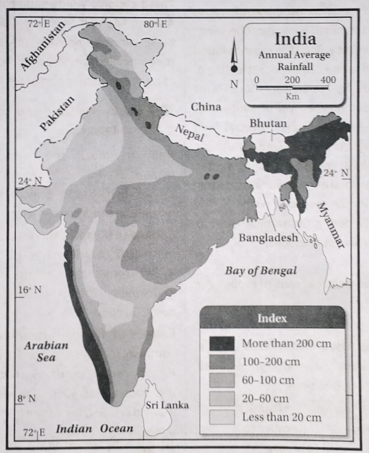
1. Uncertain monsoon rainfall: Indian agriculture is highly dependent on monsoon rainfall. About 67-72% of the total annual rainfall in India occurs from June- September. However, the onset and retreat of the monsoon winds are highly uncertain. This may lead to crop failure. Hence, irrigation is absolutely necessary.
2. Uneven distribution of rainfall: Rainfall is not evenly distributed all over the country. The north-eastern states receive more than 200 cm of rainfall, whereas the northwestern states receive as low as 75 cm of rainfall on average. Hence, irrigation is essential for agriculture in Rajasthan, Punjab, Haryana, Gujarat, and parts of the Deccan plateau.
3. Dry winters: The winters are generally dry in India. Only a few regions in the northwestern part and the Coromandel coast in the south-eastern coastal region receive some rainfall in winter. Hence, irrigation is necessary for the cultivation of rabi crops like wheat, pulses, barley, oilseeds, and boro rice.
4. Different water-holding capacities of soils: Soils like laterite and red soil have very low water-holding capacity. Thus, irrigation is needed in order to conduct agriculture on those soils.
5. HYV seeds: The High Yielding Variety seeds are now increasingly used in the country to raise the yield of crops. However, they need huge amounts of water for the best results. Hence, irrigation is necessary.
6. Agriculture round the year: Each agricultural plot is cultivated 3-4 times a year in order to increase total crop production in the country. This cannot be done unless irrigation water is available.
Question 10. What do you understand by watershed development? Discuss its importance and processes of development.
Answer:
Watershed development
The general development of any river catchment area and the water divide for the overall development of the ecosystem, environment, and water resources is known as watershed development.
Importance:
1. Identification of the water divides helps to identify the catchment area of a river system.
2. The methods of watershed management and its development depend upon the nature of the rivers and the characteristics of the catchment area.
3. The amount of water found on the surface and underground in a catchment area depends upon the area covered by the rivers, the availability of rainfall, the porosity of the rocks, etc.
Processes of development:
1. Management of slope: The steep slopes of mountainous regions are prone to heavy soil erosion. To control this, afforestation, weaving grass on open lands, building guard walls for controlling landslides, or changing the path of the mountainous course of the rivers may be done. Bad practices of agriculture like Jhum cultivation must be stopped.
2. Afforestation along contour lines: Planting trees along the contours in step farming help to reduce soil erosion, and increases the recharge of underground water by percolation.
3. Check-dams across the river: Small and low check-dams built across small rivers in the catchment area helps to conserve water locally and reduce soil erosion.
4. Flood control: In the case of flood-prone rivers, several wetlands, ponds, and canals may be dug and the silt of the rivers may be removed in order to increase the water-holding capacity of the rivers. The excess water may flow into the canals and reservoirs dug for the purpose and help in controlling floods.
5. Multi-purpose river valley projects: Multi-purpose river valley projects are taken up in river catchment areas for the purpose of flood control, prevention of soil erosion, irrigation, navigation, generation of hydroelectric power, pisciculture, etc.
Question 11. Discuss the factors which help in irrigation in India.
Answer:
The factors which help in irrigation in India
India is the land of many snow-covered mountains and numerous rivers. It also receives huge amounts of rainfall from the southwest monsoon winds. Hence, there are a number of factors that assist irrigation in the country in order to carry out agriculture.
Thus, the factors which help in irrigation are discussed below—
1. Snow-fed rivers: The rivers of northern India are snow-fed, and have water throughout the year. Thus, canals can be dug from the rivers to the agricultural fields to carry out cultivation throughout the year.
2. Vast plain land: The soft soils of the vast plains of North India allow easy construction of canals for irrigation.
3. High water table: The northern part of India receives heavy amounts of rainfall, which percolates down gradually through the soft alluvial soils and recharges underground water. Thus, the water table lies only a little below the surface of the land. This water can easily be utilized by digging wells and tube wells.
4. Rainfall: Sufficient rainfall during the rainy season fills up the rivers, canals, ponds, lakes, reservoirs, and tanks. This water can be stored for use in the dry season.
5. Construction of dams: The rivers of south India flow through the undulating terrain of the plateau. The rivers make waterfalls and are suitable for generating hydroelectric power. Thus, they are dammed at places and the water is stored in natural reservoirs in the plateau. This is used for irrigation and other purposes during the dry season.
Question 12. Describe different methods of irrigation practiced in different parts of India. OR, What are the methods of irrigation practiced in India?
Answer:
Different methods of irrigation are used in climatic conditions and the production of crops.
The different parts of India depending upon the main methods of irrigation are—
1. Canals, availability of water, nature of soil, terrain,
2. Wells and tube wells,
3. Tanks and reservoirs.
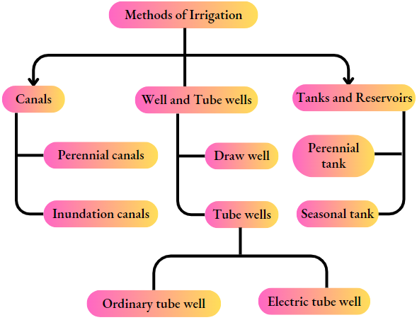
1. Canals: Two types of canals are seen in India—
perennial canals and
inundation canals.
1. Perennial canals:
- The canals drawn from perennial rivers are called perennial canals, The main rivers being perennial, the canals can transport water to the agricultural fields throughout the year,
- Such canals are seen in northern India, as the North Indian rivers are snow-fed and are perennial. E.g.-Upper Ganga canal in Uttar Pradesh, the Western Yamuna canal and the Upper Bari Doab canal in Punjab; the Medinipur canal, Eden canal, and Tidal canal in West Bengal; the Bargarh canal of Odisha, etc.
- This method of irrigation is mostly used in Uttar Pradesh.
2. Inundation canals: The canals which receive water only when the rivers are flooded are called inundation canals. Such canals can be used for irrigation only in the rainy season. E.g.—Canals drawn from the rivers Krishna, Kaveri, and Godavari.
2. Well sand tube wells:
- The wells and tube wells are dug to bring out underground water and use it for agriculture. Wells and tube wells are common in the soft alluvial soils of the northern plains.
- The depth of the wells and tube wells depends upon the depth of the water table. If the water table is only a little below the surface of the land, the wells and tube wells need not be very deep.
- Tube wells can be manually operated or attached to electric pump sets in order to draw out water.
- Wells and tube wells are commonly seen in the plains of northern India in Punjab, Uttar Pradesh, Bihar, West Bengal, Assam, etc.
- Uttar Pradesh ranks first in India in using wells and tube wells for irrigation.
- Presently, deep tube wells are being dug to draw out water from the arid regions of western India.
- Such a method of irrigation is also seen in the southern region of Tamil Nadu and Kerala.
3. Tanks and reservoirs:
- The plateau region of southern India is made up of non-porous layers of rocks. Thus, water cannot percolate down to recharge groundwater.
- The terrain is undulating. Hence, rainwater can easily be stored in reservoirs and tanks created naturally on the surface.
- The water can be used for irrigation and other purposes in the dry season.
- Tank irrigation is mostly practiced in Andhra Pradesh, Tamil Nadu, and Karnataka. It is also seen in West Bengal, Odisha, Assam, Bihar, and Jharkhand.
- Andhra Pradesh leads in tank irrigation in India.
4. Slope of land: The general slope of the land in India is from west to east. The canals can thus carry water easily from the rivers to the fields along the gently rolling plains.
5. Reservoirs: In southern India, the undulating topography provides natural depressions on land that can be used as reservoirs or tanks. Water is stored in these reservoirs in the rainy season. Canals can be dug from these reservoirs to meet the demand for water in the dry season.
6. Underground water: In many regions in India, the underground water level has gone down so low, that it is difficult to draw out water through the wells and tube wells. Thus, dependence on surface water has increased. Canals are the easiest way to divert river water to the fields.
“Rainwater harvesting techniques in India WBBSE”
Question 13. Discuss the reasons behind the usefulness of canal irrigation in India.
Answer:
Canals are a common means of irrigation in India.
Canals are of two types—
- The perennial canals are those that have water throughout the year and can irrigate fields in all seasons.
- inundation canals are those that have water only when the rivers are flooded, and can irrigate fields only in the rainy season. The reasons behind the usefulness of canal irrigation in India are—
1. Numerous rivers: India is a land of numerous rivers spread like a network over the country. Thus, canals can be easily drawn from these rivers to irrigate fields.
2. Snow-melt water: The rivers of North India are snowed. They have water throughout the year. Thus, canals drawn from them are also perennial and are used to irrigate agricultural fields throughout the year.
3. Landforms: The northern part of India is a vast plain land made up of soft alluvial soils. Thus, it is easy to draw canals from the rivers through the plains according to the need
4. Slope of land: The general slope of the land in India is from west to east. The canals can thus carry water easily from the rivers to the fields along the gently rolling plains.
5. Reservoirs: In southern India, the undulating topography provides natural depressions on land that can be used as reservoirs or tanks. Water is stored in these reservoirs in the rainy season. Canals can be dug from these reservoirs to meet the demand of water in the dry season.
6. Underground water: In many regions in India, the underground water level has gone down so low, that it is difficult to draw out water through the wells and tube wells. Thus, dependence on surface water has increased. Canals are the easiest way to divert river water to the fields. In India, presently about 26% of agricultural fields are irrigated by canals.
Question 14. Discuss the effects of excessive irrigation.
Answer:
The effects of excessive irrigation are as follows—
1. Deficiency of oxygen: Too much irrigation tend to fill up the air spaces within the soil with water. This drives out the air from the soil. The roots of the plants fail to absorb sufficient oxygen from the soil. Hence, the growth of plants is hampered.
2. Disease of plants: Bacteria and germs tend to multiply fast in waterlogged soil. They attack the roots of the plants and result in their decay. Also, the growth of fungus on the stems, leaves, and fruits of the plants causes various plant diseases.
3. Toxic chemicals: The stagnation of water in the soil for a long time causes the accumulation of toxic chemicals like hydrogen sulfide and volatile fatty acids.
4. Reduction of fertility: Agriculture is carried out in the fields throughout the year using irrigation and growing the same crop.
This constantly reduces the fertility of the soil. After a few years, the fertility may reduce to such an extent that the soil fails to grow any more crops at all.
5. Increase of salinity: Excessive irrigation causes the salts deposited in the lower layers of the soil to dissolve in the water and rise up to the top layers. This gradually makes the soil more saline.
6. Lowering of water table: Supply of irrigation water in one area may result in lowering of the water table in the area from where the water has been drawn out through wells and tube wells.
7. Others:
1. Excessive irrigation may result in changes in the ecosystem and affect the environment. Excess irrigated water mixed with fertilizers and pesticides when drains into the nearby water body cause water pollution.
2. Chances of water-borne diseases may increase.
3. Arsenic pollution and contamination of water may occur.
Question 15. discuss the methods of Watershed development
Answer:
The methods of Watershed development
The proper and judicious use of water is known as the conservation of water. In other words, conservation of water refers to the optimum and logical use of water, control of wastage, reduce unscientific and reckless use of water, water resource management, and storage for future use.
Importance: Shortage of fresh and potable water is a burning problem all over the world. More than 50% of the world’s population suffers from a scarcity of water.
This accounts for about 40% of the population in about 80 countries. Although nearly three-fourths of the earth’s surface is filled with water, 97% of it is saline and unusable.
Only about 3% of the total water is fresh, but only 0.3% is easily available in rivers, ponds, or lakes. With the increase in population, demand for water also increases, and per capita availability of water gradually decreases.
Unplanned extraction of groundwater to meet the rising demand for water has lowered the water table in some areas to such an extent that acute scarcity of water has resulted in those areas.
In India, 15% of the total block of the country suffers from an acute crisis of water. Unless the available water is used carefully, logically, and playfully, more areas will face water crises in the future. Hence, the conservation of water is very important and necessary in India.
Question 16. Discuss the methods of watershed development.
Answer:
Definition of watershed development: The overall scientific development of the watershed of a river is known as watershed development. This includes the conservation of the ecosystem, development and proper management of resources, and overall development of the region.
Methods: Several steps have been taken up in the process of watershed development—
1. Slope management: The high and steep slopes of the upper course of the rivers are prone to landslides and soil erosion. These slopes are taken care of by planting trees, covering the open soil with grasses, prohibiting hum cultivation, building guard walls along the tree beds and even diverting the course of the rivers from where the slope is very steep and dangerous.
2. Flood control: The depth of ponds, canals, wetlands, and even rivers is increased by digging out silt and mud. This increases the water-holding capacity of the water bodies and helps to control floods.
3. Badlands: The formation of badlands may be controlled by building check dams at several places, which will stop the flow of rainwater as surface runoff and control soil erosion.
4. Contour plowing: Trees are planted along contour lines or particular heights, in order to prevent soil erosion. The forests thus created reduce the speed of the surface runoff water and help in recharge of groundwater by percolation of rainwater.
5. Small dams: Small dams are constructed on rivers to control soil erosion and conserve water locally.
6. Multi-purpose projects: Multi-purpose projects are undertaken for the purposes of flood control, generation of hydroelectric power, irrigation, pisciculture, navigation, controlling soil erosion, promotion of tourism, and overall conservation of water.
Question 17. Discuss rainwater harvesting in India.
Answer:
Rainwater harvesting in India
The method of collecting and conserving rainwater from the roofs or open ground to meet the demand for water is known as rainwater harvesting. The water thus collected is used all year round for various purposes, especially in the dry season.
Methods of rainwater harvesting: Rainwater may be collected by different methods—
1. Collection of surface runoff: Construction of reservoirs: Large reservoirs, tanks, ponds, etc. are constructed to hold rainwater and excess river water so that it can be used in the dry season. Accordingly, a pilot scheme was launched in 2005 to restore and augment the storage capacity of water bodies. This scheme was approved in 26 districts across 15 states covering 1098 water bodies.
2. Check-dams: Large dams are expensive to build, and often displace a large number of people living along the rivers or in the catchment area. Check-dams or smaller dams are less expensive and helpful in holding river water in lesser amounts. This is a successful method of flood control as well.
3. Collecting rainwater: India receives ample rain from the southwest monsoon winds. If this water can be held back properly, the crisis of water in the dry season can be met.
It is very essential to hold rainwater in West Bengal, Bihar, Jharkhand, Odisha, Chhattisgarh, Madhya Pradesh, Andhra Pradesh, and Karnataka in order to recharge the reserves of the water resource. Tamil Nadu has excelled in this regard by harvesting rainwater on rooftops since 2001.
4. Proper use of surface water: The surface water stored in reservoirs, ponds, and lakes is used for irrigation. Efforts can be made to increase the efficiency of using this water from 35-40% to 60%.
2. Conservation of groundwater:
1. Implementation of rules and regulations: Implementation of rules and regulations will help to prevent the unplanned use of groundwater, its misuse, and waste. This will help in the conservation of groundwater.
2. Increase the level of water percolation: In places where the land surface is open, the rainwater passes by very fast and does not percolate underground to recharge the groundwater table. In such cases, pipelines and other arrangements may be made so that rainwater reaches deep down and the underground water table is recharged.
3. National policies: The ‘Swajaldhara’ project has been started in 2002 and the ‘Bharat Nirman’ project has been started in 2005-06 for distributing water in rural areas.
Chapter 5 India-Physical Environment Topic 3 Water Resources Of India Short Explanatory Anser Type Questions
Question 1. Why is the river Brahmaputra flood-prone? OR, Why do floods occur in Assam every year?
Answer:
The main river of Assam is Brahmaputra. Every year during the monsoon season, the river overflows its channel and flooding occurs in the lower Assam valley.
The causes of flood in Assam are—
1. Gentle slope of the land: The slope of the land in Assam valley through which the river Brahmaputra flows, is very gentle. Hence, the river loses its speed and load-carrying capacity. Thus, the heavy amounts of load brought down by the river and its tributaries from the upper course get deposited in the river bed in this region. This reduces the depth and water-holding capacity of the river and makes it flood-prone.
2. Heavy rainfall: The Assam valley receives heavy rainfall during the southwest monsoon season, which supplies huge quantities of water ‘ to the river Brahmaputra. Also, the snow melt water brought down from the upper course of the river (where it is known as Tsangpo, in Tibet) is added on. This increases the volume of water to such an extent that the river channel overflows. The result is severe flooding in the lower course of the river.
Question 2. What is an ideal river? Why is the river Ganga called an ideal river?
Answer:
Ideal river: A river that exhibits the upper, middle, and lowers courses from its source in the mountains or highlands to its mouth in the sea or ocean is called an ideal river. An ideal river generally erodes in the upper course, carries the load in the middle course, and deposits the load in the lower course.
Ganga as an ideal river: The river Ganga rises in the Gomukh cave of the Gangotri glacier in the Greater Himalayas. The upper course of the river stretches from Gomukh to Haridwar. The middle course of the river extends from Haridwar to Rajmahal hills. From south of the Rajmahal hills to the mouth of the river in the Bay of Bengal through the vast delta region lies its lower course. As the river Ganga exhibits all three courses prominently, it is called an ideal river.
Question 3. Describe the course of the river Ganga.
Answer:
The three major rivers of northern India are—the Ganga, Indus, and Brahmaputra.
1. The Ganga: The total length of the river Ganga is 2525 km, of which 2017 km lies in India. This is the most important river in India. The course of the Ganga can be divided into three parts—
1. Upper Course: The river Ganga rises from the Gomukh cave of the Gangotri glacier in the Garhwal Himalayas. Here the river is known as the river Bhagirathi. The river Alaknanda meets the river Bhagirathi at Devaprayag, and the combined flow is known as the river Ganga. The stretch of the river from its source up to Haridwar is known as its upper course.
2. Middle course: The middle course of the river Ganga stretches from Haridwar to the Rajmahal hills. The right bank tributaries Yamuna and Son and the left bank tributaries Gomti, Ghaghara, Ramganga, Gandak, Kosi, etc. meet the river Ganga in this course and multiply both its load and volume of water. The most important tributary of the river Ganga is the river, Yamuna.
3. Lower course: The lower course of the river Ganga extends from south of Rajmahal hills to the mouth in the Bay of Bengal. The Ganga after entering West Bengal bifurcates into two branches near Dhulian of Murshidabad. One of the branches enters Bangladesh as Padma and later drains into the Bay of Bengal as the river Meghna.
The other branch flows through West Bengal as the Bhagirathi-Hooghly river before meeting the Bay of Bengal. The right bank tributaries in this course are—Ajay, Damodar, Kangsabati, and Rupnarayan. The left bank’s tributaries are— Jalangi,
Mathabhanga, Churni, etc. The river Ganga together with the river Brahmaputra forms the largest delta in the world.
2. The Indus: The Indus is the longest and the most important river of northwestern India. It stretches for 2900 km, of which 1114 km lies in India. It rises from the Senge Khabab glacier near the Manas Sarovar in the Greater Himalayas. It flows through Jammu and Kashmir and then turns southwards near Nanga Parbat, entering Pakistan. From there it flows southwards and meets the Arabian Sea (southeast of Karachi).
The most important left-bank tributaries of the river Indus are— Jhelum, Chenab, Ravi, Beas, and Sutlej. These tributaries flow over Jammu and Kashmir, Himachal Pradesh, and Punjab. The right bank tributaries are— Shyok, Gilgit, Shigar, etc. The river Indus forms deep gorges near the Nanga Parbat massif. It forms a small delta at its mouth.
3. The Brahmaputra: The river Brahmaputra is the most important river in north-eastern India. It flows for 2900 km, of which 916 km lies in India. The river rises from the Chemayungdung glacier in Tibet. Here it flows as river Tsangpo over the Tibetan plateau for about 1500 km.
Near the Namcha Barwa peak, it takes a sharp turn towards the southwest and enters Arunachal Pradesh as river Dihang. The Dihang meets the rivers Dibang and Lohit near Sadiya in Assam. The combined flow of these three rivers flows as the river Brahmaputra westwards over Assam till Dhubri.
From Dhubri it turns southwards and enters Bangladesh as the river Jamuna. It meets the river Padma near Goalondo and enters the Bay of Bengal. The course of the river Brahmaputra in Assam is highly braided, forming several islands. The island of Majuli near Jorhat in Assam is the largest riverine island in India.
Some important right-bank tributaries of the river Brahmaputra are— Subansiri, Kameng or Jiya Bharali, Manas, and Sankosh. Some left-bank tributaries of the river Brahmaputra are- Dhansiri, Kopili, and Buri Dihing.
Question 4. Why deltas have not been formed on the mouth of west-flowing rivers in India? OR, Why do the rivers meeting the Arabian Sea not form deltas near their mouths? OR, Why do the rivers Narmada and Tapti not form deltas near their mouths? OR, Why deltas have not been formed at the mouth of west flowing rivers of India?
Answer:
The west-flowing rivers of India generally do not form deltas because—
1. Short length of the rivers: The rivers flow for a short distance, and hence collect a very little amount of eroded materials.
2. Speed: The rivers (E.g.—Narmada and Tapti) flow through steep slopes of rift valleys. Hence, the water flows at high speed and removes whatever eroded materials are collected. Hence, the chances of the formation of deltas in their mouths are less.
3. Less erosion: The rivers flow through a region made up of hard and resistant igneous and metamorphic rocks. Hence, the rate of erosion is very less, which accounts for a very less generation of silt.
4. Lesser number of tributaries: The west-flowing rivers have a lesser number of tributaries. Thus, the total load of eroded materials collected by the rivers is very less.
5. Slope near the mouths of the rivers: The slope of the continental shelf near the mouths of the rivers is steep, which does not allow any deposition of silt. Hence, this repels the formation of a delta.
Question 5. What are the main causes of pollution in the rivers of India? What steps have been taken up for controlling pollution of the river Ganga?
Answer:
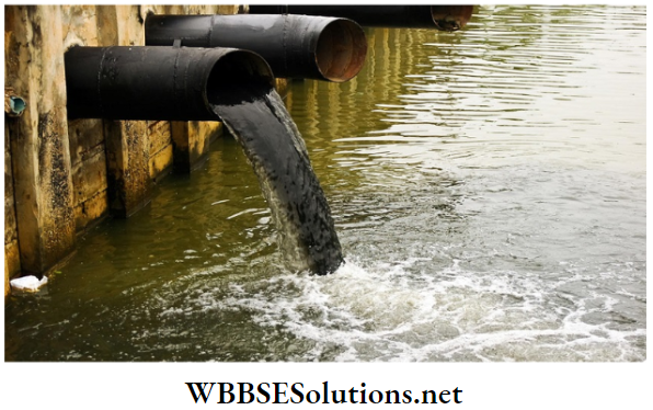
Causes of pollution of the rivers of India:
1. Disposal of wastes from household factories and sewage lines into the rivers.
2. Disposal of dead animals into the rivers.
3. Washing down of pesticides and chemical fertilizers by rainwater into the rivers.
4. Bathing domestic animals, washing utensils and clothes in rivers.
5. Lack of consciousness regarding environmental pollution and degradation.
Steps taken for controlling pollution of the river Ganga: The ‘Central Ganga Authority’ was formed in 1985 by the government of India.
The ‘Ganga Action Plan’ has been taken up by this organization for controlling pollution of the river Ganga. Presently, various plans are being executed in many places.
Once the plans are fully executed, it is expected that pollution of the river Ganga will be controlled to a large extent. Organizations like ‘National Ganga River Basin Authority’ have been formed and programs like ‘Namo Gange’ have been taken up to conserve the water of the river Ganga.
Question 6. Describe the course of a river flowing through a rift valley in India.
Answer:
The course of a river flowing through a rift valley in India
The river Narmada is a river flowing through a rift valley in India. The course of the river: The river Narmada rises in the Amarkantak plateau (1057 m high) in Madhya Pradesh. Itflowsfora a stretch of 1312 km towards the west through Chhattisgarh, Madhya Pradesh, Maharashtra, and Gujarat before draining into the Gulf of Khambat.
In the first 300 km stretch of its flow, the river has the famous waterfalls of Kapil Dhara and Dhuandhar. The river flows through a plain land from Bharuch in Gujarat to the mouth in the Gulf of Khambat. Here the river widens and covers an area of about 20 km.
“Water quality issues in India Class 10 Geography”
Question 7. Although most of the rivers of South India are east flowing, Why are the rivers Narmada and Tapti west flowing?
Answer:
Rivers flow in the direction of the slope of the land. The general slope of the southern part of India is from west to east. Hence, most of the South Indian rivers (e.g.—Godavari, Krishna, Kaveri) are east flowing. But the rivers Narmada and Tapti flow through rift valleys formed between the Vindhya and Satpura ranges. The slope of these rift valleys, formed due to faulting, is from east to west. Hence, these rivers are west flowing.
Question 8. What is the river Brahmaputra known as in the different parts of its course?
Answer:
River Brahmaputra known as in the different parts of its course
The river Brahmaputra rises from the Chemayugdung glacier near Rakshastal and Manas Sarovar in Tibet. The river is known by different names in different parts of its course.
1. The river is known as Tsangpo from its source to Namcha Barwa in the east.
2. The southward flow of the river from there to Sadiya of Assam through Arunachal Pradesh is known as Dihang.
3. The Dihang meets with the rivers Dibang and Lohit near Sadiya. The combined flow of these rivers towards the west is known as the river Brahmaputra till Dhubri in Assam.
4. The river Brahmaputra enters Bangladesh after this and meets the branch of the river Ganga. Here it is known as river Jamuna, which flows southwards till Aricha in Bangladesh.
5. Beyond Aricha, the south-eastward flow of the river (Ganga and Jamuna) is known as the river Padma. After this stretch, the river Padma meets the river Meghna and finally drains into the Bay of Bengal.
Question 9. Describe the upper course of the river Ganga.
Answer:
The three major rivers of northern India are—the Ganga, Indus, and Brahmaputra.
1. The Ganga: The total length of the river Ganga is 2525 km, of which 2017 km lies in India. This is the most important river in India. The course of the Ganga can be divided into three parts—
1. Upper Course: The river Ganga rises from the Gomukh cave of the Gangotri glacier in the Garhwal Himalayas. Here the river is known as the river Bhagirathi. The river Alaknanda meets the river Bhagirathi at Devaprayag, and the combined flow is known as the river Ganga. The stretch of the river from its source up to Haridwar is known as its upper course.
2. Middle course: The middle course of the river Ganga stretches from Haridwar to the Rajmahal hills. The right bank tributaries Yamuna and Son and the left bank tributaries Gomti, Ghaghara, Ramganga, Gandak, Kosi, etc. meet the river Ganga in this course and multiply both its load and volume of water. The most important tributary of the river Ganga is the river, Yamuna.
3. Lower course: The lower course of the river Ganga extends from south of Rajmahal hills to the mouth in the Bay of Bengal. The Ganga after entering West Bengal bifurcates into two branches near Dhulian of Murshidabad. One of the branches enters Bangladesh as Padma and later drains into the Bay of Bengal as the river Meghna.
The other branch flows through West Bengal as the Bhagirathi-Hooghly river before meeting the Bay of Bengal. The right bank tributaries in this course are—Ajay, Damodar, Kangsabati, and Rupnarayan. The left bank’s tributaries are— Jalangi,
Mathabhanga, Churni, etc. The river Ganga together with the river Brahmaputra forms the largest delta in the world.
2. The Indus: The Indus is the longest and the most important river of northwestern India. It stretches for 2900 km, of which 1114 km lies in India. It rises from the Senge Khabab glacier near the Manas Sarovar in the Greater Himalayas. It flows through Jammu and Kashmir and then turns southwards near Nanga Parbat, entering Pakistan. From there it flows southwards and meets the Arabian Sea (southeast of Karachi).
The most important left-bank tributaries of the river Indus are— Jhelum, Chenab, Ravi, Beas, and Sutlej. These tributaries flow over Jammu and Kashmir, Himachal Pradesh, and Punjab. The right bank tributaries are— Shyok, Gilgit, Shigar, etc. The river Indus forms deep gorges near the Nanga Parbat massif. It forms a small delta at its mouth.
3. The Brahmaputra: The river Brahmaputra is the most important river in north-eastern India. It flows for 2900 km, of which 916 km lies in India. The river rises from the Chemayungdung glacier in Tibet. Here it flows as river Tsangpo over the Tibetan plateau for about 1500 km.
Near the Namcha Barwa peak, it takes a sharp turn towards the southwest and enters Arunachal Pradesh as river Dihang. The Dihang meets the rivers Dibang and Lohit near Sadiya in Assam. The combined flow of these three rivers flows as the river Brahmaputra westwards over Assam till Dhubri.
From Dhubri it turns southwards and enters Bangladesh as the river Jamuna. It meets the river Padma near Goalondo and enters the Bay of Bengal. The course of the river Brahmaputra in Assam is highly braided, forming several islands. The island of Majuli near Jorhat in Assam is the largest riverine island in India.
Some important right-bank tributaries of the river Brahmaputra are— Subansiri, Kameng or Jiya Bharali, Manas, and Sankosh. Some left-bank tributaries of the river Brahmaputra are- Dhansiri, Kopili, and Buri Dihing.
Question 10. Describe the course of the river Brahmaputra. What is the river known as in different parts of its course?
Answer:
The three major rivers of northern India are—the Ganga, Indus, and Brahmaputra.
1. The Ganga: The total length of the river Ganga is 2525 km, of which 2017 km lies in India. This is the most important river in India. The course of the Ganga can be divided into three parts—
1. Upper Course: The river Ganga rises from the Gomukh cave of the Gangotri glacier in the Garhwal Himalayas. Here the river is known as the river Bhagirathi. The river Alaknanda meets the river Bhagirathi at Devaprayag, and the combined flow is known as the river Ganga. The stretch of the river from its source up to Haridwar is known as its upper course.
2. Middle course: The middle course of the river Ganga stretches from Haridwar to the Rajmahal hills. The right bank tributaries Yamuna and Son and the left bank tributaries Gomti, Ghaghara, Ramganga, Gandak, Kosi, etc. meet the river Ganga in this course and multiply both its load and volume of water. The most important tributary of the river Ganga is the river, Yamuna.
3. Lower course: The lower course of the river Ganga extends from south of Rajmahal hills to the mouth in the Bay of Bengal. The Ganga after entering West Bengal bifurcates into two branches near Dhulian of Murshidabad. One of the branches enters Bangladesh as Padma and later drains into the Bay of Bengal as the river Meghna.
The other branch flows through West Bengal as the Bhagirathi-Hooghly river before meeting the Bay of Bengal. The right bank tributaries in this course are—Ajay, Damodar, Kangsabati, and Rupnarayan. The left bank’s tributaries are— Jalangi,
Mathabhanga, Churni, etc. The river Ganga together with the river Brahmaputra forms the largest delta in the world.
2. The Indus: The Indus is the longest and the most important river in northwestern India. It stretches for 2900 km, of which 1114 km lies in India. It rises from the Senge Khabab glacier near the Manas Sarovar in the Greater Himalayas. It flows through Jammu and Kashmir and then turns southwards near Nanga Parbat, entering Pakistan. From there it flows southwards and meets the Arabian Sea (southeast of Karachi).
The most important left-bank tributaries of the river Indus are— Jhelum, Chenab, Ravi, Beas, and Sutlej. These tributaries flow over Jammu and Kashmir, Himachal Pradesh, and Punjab. The right bank tributaries are— Shyok, Gilgit, Shigar, etc. The river Indus forms deep gorges near the Nanga Parbat massif. It forms a small delta at its mouth.
3. The Brahmaputra: The river Brahmaputra is the most important river in north-eastern India. It flows for 2900 km, of which 916 km lies in India. The river rises from the Chemayungdung glacier in Tibet. Here it flows as river Tsangpo over the Tibetan plateau for about 1500 km.
Near the Namcha Barwa peak, it takes a sharp turn towards the southwest and enters Arunachal Pradesh as river Dihang. The Dihang meets the rivers Dibang and Lohit near Sadiya in Assam. The combined flow of these three rivers flows as the river Brahmaputra westwards over Assam till Dhubri.
From Dhubri it turns southwards and enters Bangladesh as the river Jamuna. It meets the river Padma near Goalondo and enters the Bay of Bengal. The course of the river Brahmaputra in Assam is highly braided, forming several islands. The island of Majuli near Jorhat in Assam is the largest riverine island in India.
Some important right-bank tributaries of the river Brahmaputra are— Subansiri, Kameng or Jiya Bharali, Manas, and Sankosh. Some left-bank tributaries of the river Brahmaputra are- Dhansiri, Kopili, and Buri Dihing.
Question 11. Describe the course of the river Indus.
Answer:
The three major rivers of northern India are—the Ganga, Indus, and Brahmaputra.
1. The Ganga: The total length of the river Ganga is 2525 km, of which 2017 km lies in India. This is the most important river in India. The course of the Ganga can be divided into three parts—
1. Upper Course: The river Ganga rises from the Gomukh cave of the Gangotri glacier in the Garhwal Himalayas. Here the river is known as the river Bhagirathi. The river Alaknanda meets the river Bhagirathi at Devaprayag, and the combined flow is known as the river Ganga. The stretch of the river from its source up to Haridwar is known as its upper course.
2. Middle course: The middle course of the river Ganga stretches from Haridwar to the Rajmahal hills. The right bank tributaries Yamuna and Son and the left bank tributaries Gomti, Ghaghara, Ramganga, Gandak, Kosi, etc. meet the river Ganga in this course and multiply both its load and volume of water. The most important tributary of the river Ganga is the river, Yamuna.
3. Lower course: The lower course of the river Ganga extends from south of Rajmahal hills to the mouth in the Bay of Bengal. The Ganga after entering West Bengal bifurcates into two branches near Dhulian of Murshidabad. One of the branches enters Bangladesh as Padma and later drains into the Bay of Bengal as the river Meghna.
The other branch flows through West Bengal as the Bhagirathi-Hooghly river before meeting the Bay of Bengal. The right bank tributaries in this course are—Ajay, Damodar, Kangsabati, and Rupnarayan. The left bank’s tributaries are— Jalangi,
Mathabhanga, Churni, etc. The river Ganga together with the river Brahmaputra forms the largest delta in the world.
2. The Indus: The Indus is the longest and the most important river in northwestern India. It stretches for 2900 km, of which 1114 km lies in India. It rises from the Senge Khabab glacier near the Manas Sarovar in the Greater Himalayas. It flows through Jammu and Kashmir and then turns southwards near Nanga Parbat, entering Pakistan. From there it flows southwards and meets the Arabian Sea (southeast of Karachi).
The most important left-bank tributaries of the river Indus are— Jhelum, Chenab, Ravi, Beas, and Sutlej. These tributaries flow over Jammu and Kashmir, Himachal Pradesh, and Punjab. The right bank tributaries are— Shyok, Gilgit, Shigar, etc. The river Indus forms deep gorges near the Nanga Parbat massif. It forms a small delta at its mouth.
3. The Brahmaputra: The river Brahmaputra is the most important river in north-eastern India. It flows for 2900 km, of which 916 km lies in India. The river rises from the Chemayungdung glacier in Tibet. Here it flows as river Tsangpo over the Tibetan plateau for about 1500 km.
Near the Namcha Barwa peak, it takes a sharp turn towards the southwest and enters Arunachal Pradesh as river Dihang. The Dihang meets the rivers Dibang and Lohit near Sadiya in Assam. The combined flow of these three rivers flows as the river Brahmaputra westwards over Assam till Dhubri.
From Dhubri it turns southwards and enters Bangladesh as the river Jamuna. It meets the river Padma near Goalondo and enters the Bay of Bengal. The course of the river Brahmaputra in Assam is highly braided, forming several islands. The island of Majuli near Jorhat in Assam is the largest riverine island in India.
Some important right-bank tributaries of the river Brahmaputra are— Subansiri, Kameng or Jiya Bharali, Manas, and Sankosh. Some left-bank tributaries of the river Brahmaputra are- Dhansiri, Kopili, and Buri Dihing.
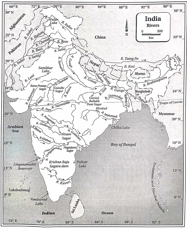
Question 12. Classify the rivers of India according to the size of their basins.
Answer:
The rivers of India can be classified into three types according to the size of their basins.
1. Main rivers: The rivers that have a total basin area of more than 20000 sq. km are known as main rivers. There are 12 such rivers namely—the Ganga, Indus, Brahmaputra, Narmada, Tapti, Mahanadi, Godavari, Sabarmati, Krishna, Kaveri, Mahi, Brahmani, Subarnarekha, and Pennar.
2. Medium rivers: About 46 rivers in India have a basin size of 2000-20000 sq. km. Such rivers are known as medium rivers. E.g.—Rivers Sharavathi Vaigai, Periyar, Palar, and Baitarini.
3. Small rivers: More than 55 rivers in India have a basin smaller than 2000 sq. km. Such rivers are called small rivers. E.g.—Rivers Luni, Banas, Rachol and Damon Ganga.
Question 13. Why is India called the land of rivers?
Answer:
India is called the ‘land of rivers’ because—
1. The rivers of India carry about 186900 crore cubic meters of water (about 85% by the main rivers, 7% by the medium ri rivers, 4% by the small rivers, and the remaining 4% by other streams).
2. The ancient civilization of the Indus, the old cities of Allahabad, Varanasi, and Kanpur, and modern cities and towns have grown on river banks in different phases of time.
3. Agriculture in India is largely dependent on the rivers, especially for the alluvial soil and water.
4. Important industries like cotton textile, jute textile, sugar, etc. have come up near riverbanks
5. The rivers of India are important for irrigation, hydel power generation, navigation, trade and commerce through waterways, and many other uses. Hence, India is called the ‘land of rivers’.
Question 14. Name some flood-prone regions of India.
Answer:
According to the ‘Rashtriya Barh Ayog’, the most flood-prone regions of India are—
1. The river basins of Ganga, Yamuna, Ghaghara, and Gandak in Uttar Pradesh.
2. The river basins of Kosi and Son in Bihar.
3. Western Punjab
4. South-eastern Haryana
5. Eastern Rajasthan
6. North-eastern and southern parts of Gujarat
7. Coastal regions of Andhra Pradesh.
8. Coastal regions of Odisha.
9. The Brahmaputra basin of Assam.
10. The Ganga river basin and coastal regions of West Bengal.
Question 15. Discuss the role of lakes and reservoirs as sources of water resources.
Answer:
The lakes and other water bodies are considered to be important sources of water resources for the following reasons—
1. Lakes serve as sources of drinking water.
2. Lakes and reservoirs help to hold water and control floods.
3. The lakes and reservoirs supply water for irrigation in the dry season.
4. They help to recharge groundwater through percolation.
5. They help to maintain the aquatic ecosystems.
6. Pisciculture can be practiced in lakes and reservoirs, which gives rise to a new economic activity.
7. They are also used for water sports which, in turn, promotes tourism.
Question 16. Why are the rivers of South India not navigable?
Answer:
The rivers of South India are not navigable because—
1. Most of the rivers are rainfed. They either dry up or have scanty water in dry seasons, which is not suitable for navigation.
2. The rivers flow through the rough and undulating terrain of the plateau. They have immense speed in some regions and form waterfalls. Hence, they are not navigable.
Question 17. Why are the rivers of South India non-perennial?
Answer:
The rivers of South India rise in the plateau region that is not snow-covered. Thus, they receive water only from rainfall and not from the melting of snow. Hence, they have sufficient water only in the rainy season and tend to dry up during the dry season. This makes them non-perennial.
Question 18. Discuss the importance of irrigation in
Answer:
The importance of irrigation in India is as follows—
1. Irrigation helps in carrying out agriculture throughout the year.
2. Irrigation helps to grow HYV seeds, which yield more crops.
3. Irrigation helps to carry out agriculture in dry regions or regions of scanty rainfall.
4. Crops like Boro rice need large quantities of water but can be grown in the dry winter season with the help of irrigation.
5. Indian agriculture is dependent on monsoons. Crop failures due to the erratic nature of the monsoons can be controlled with the help of irrigation.
Question 19. Mention the advantages of multipurpose river valley projects.
Answer:
The advantages of multi-purpose river valley projects are—
1. Flood control.
2. Irrigation with the help of water stored in the reservoirs behind dams.
3. Generation of hydroelectric power.
4. Supply of drinking water.
5. Control of soil erosion.
6. Dams constructed on the rivers serve as bridges.
7. Pisciculture in the reservoirs behind the dams.
8. Promotes tourism due to scenic beauty.
Question 20. List the advantages and disadvantages of well and tube well irrigation.
Answer:
Advantages of well and tube well irrigation:
1. Wells and tube wells are easy to operate.
2. The cost of construction, as well as maintenance of wells and tube wells, is low. So, it can be afforded by most farmers.
3. Wells and tube wells can be dug near the agricultural fields according to necessity.
Disadvantages of well and tube well irrigation:
1. Wells and tube wells cannot be used to draw huge quantities of water.
2. Wells and tube wells become useless if the groundwater level goes down considerably.
3. Excessive drawing of groundwater through wells and tube wells may cause arsenic and fluoride pollution of water.
Question 21. Why is tank irrigation commonly practiced in south India?
Answer:
Tank irrigation is popular in South India because of the following reasons—
1. There are numerous natural reservoirs and artificial tanks in the plateau region of Tamil Nadu, Karnataka, and Andhra Pradesh.
2. The surface of this region is mostly non-porous and hence, rainwater cannot percolate down and recharge the groundwater.
3. The hard rocky surface of the land is not suitable for digging canals.
4. The region mostly lies in the rainshadow area. The rivers are non-perennial, and cannot be depended upon for irrigation throughout the year.
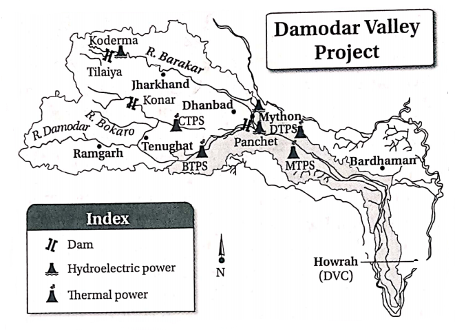
Question 22. What is the Damodar Valley multipurpose river valley project?
Answer:
Damodar Valley multipurpose river valley project
The Damodar Valley Project is the first multi-purpose river valley project taken up in India in 1948. The main objectives of the project are flood control, power generation, and irrigation along with several secondary objectives, such as controlling soil erosion and environmental pollution, pisciculture, etc.
For flood control, dams have been constructed at Tilaiya, Maithon, Panchet, Konar, and Tenughat. Thermal and hydel power stations have been set up at Mejia, Durgapur, Chandrapura, Maithon, Koderma, Bokaro (thermal), Maithon, Tilaiya, and Panchet (hydel power). Extensive irrigation canals provide water to the West and East Bardhaman and Howrah districts of West Bengal. For this purpose, a barrage has been constructed at Durgapur.
Question 23. Mention the advantages and disadvantages of canal irrigation.
Answer:
Advantages of canal irrigation:
1. Perennial canals help in agriculture throughout the year.
2. The initial cost of the construction of canals is high, but the cost of maintenance is low.
3. The alluvial soils brought down by the rivers flow into the canals along with the water and spreads on the agricultural fields. This makes the soil more fertile.
4. It irrigates a vast area.
Disadvantage of canal irrigation:
1. Canals can be used for irrigation only in the plains.
2. Soils tend to become saline due to too much irrigation through canals.
3. Canals may lead to floods in the rainy season.
4. Initial cost of construction is high.
Question 24. Name some of the multi-purpose river valley projects in India.
Answer:
Some of the important multi-purpose river valley projects in India are—
1. Bhakra-Nangal Project: This is the largest multi-purpose river valley project in India, built on the river Sutlej in Himachal Pradesh and Punjab.
2. Hirakud Project: This has been built on the river Mahanadi in Odisha for irrigation and other purposes.
3. Mayurakshi Project: This project has been built on the river Mayurakshi, West Bengal. Dams and barrages have been built at Massanjore and Tilpara for supplying irrigation water to the nearby areas of the Birbhum district.
4. Kosi Project: This project has been built on the river Kosi in Bihar.
5. Gandak Project: This project has been built on the river Gandak for providing irrigation to Nepal, Uttar Pradesh, and Bihar.
6. Nagarjuna Sagar Project: This project on the river Krishna is an important multi-purpose project in Telangana.
Question 25. What do you mean by a multi-purpose river valley project?
Answer:
Multi-purpose river valley project
A project where a river is dammed at one or more places and the water is used for several purposes, is called a multi-purpose river valley project. The river is dammed for flood control, Irrigation, generation of hydroelectric power,
navigation, pisciculture, control of soil erosion, afforestation, supply of drinking water, construction of roads, and promoting tourism. In India, several multi-purpose river valley projects have been built on the rivers Damodar, Sutlej, Mahanadi, Krishna, Godavari, etc.
Question 26. What purposes are served by the multi-purpose river valley projects?
Answer:
In multi-purpose river valley projects, the rivers are dammed and the water is stored in huge reservoirs behind the dams.
The different purposes served by the multi-purpose river valley projects are as follows—
1. Canals are dug from the reservoirs to the agricultural fields to provide irrigation water throughout the year.
2. The water stored in the reservoirs may be used for hydel power generation.
3. Flooding of the river basins during monsoon season may be controlled by storing the excess water behind dams.
4. The rivers as well as the canals may be used for navigation.
5. Pisciculture is practiced in the reservoirs.
6. The stored water is purified to supply drinking water.
7. Soil erosion is controlled by reducing the speed of the rivers. Further, trees are planted in the river basin and around the reservoirs for soil and environmental conservation.
8. The scenic beauty of the dams and reservoirs attracts tourists.
9. The dams act as bridges over the rivers. In India, multi-purpose river valley projects have been built on several rivers like Damodar, Sutlej, Mayurakshi, Mahanadi, Krishna, and Godavari.
Question 27. Discuss the main purposes of the Damodar Valley Project.
Answer:
The main purposes of the Damodar Valley Project are—
1. Generation of hydroelectricity to be supplied to the mineral-rich areas of the Damodar Valley for the development of industries.
2. Controlling flood in the lower course of the river Damodar.
3. Irrigation of agricultural land and reclamation of fallow infertile land for agriculture.
4. Reduction of soil erosion, conservation of soil, and controlling environmental degradation.
5. Development of other economic activities like pisciculture.
6. Development of tourism.
Question 28. Differentiate between irrigation dams and multi-purpose dams.
Answer:
The difference between irrigation dams and multi-purpose dams
| Point of difference |
Irrigation dams |
Multi-purpose dams |
| Purpose |
Mainly constructed to provide irrigation to agricultural fields. |
Mainly constructed for the generation of hydel power, flood control, navigation, pisciculture, along with irrigation of agricultural fields. |
| Water storage |
Usually, the excess water during the monsoon season is stored behind the dams.
Once the agricultural season is over, there is no problem if the water behind the dams dries up. |
Usually, water is stored throughout the year for several purposes like pisciculture, navigation, and hydel power generation apart from irrigation. |
| Examples |
Irrigation dam on the river Kangsabati in West Bengal. |
Multi-purpose dams on the rivers Damodar and Mayurakshi in West Bengal. |
Question 29. Why there are more perennial canals In North India than In South India?
Answer:
The canals constructed from perennial rivers are called perennial canals. These canals have water throughout the year. In India, the rivers of South India are only rainfed. Most of them tend to dry up or have very little water during the dry season. On the other hand, the rivers of North India are both rainfed and snowed i.e., they are perennial. Hence, more perennial canals are present in North India than in South India.
Question 30. Why is irrigation necessary for agriculture in India?
Answer:
Irrigation is necessary for agriculture in India because—
1. Indian agriculture is dependent on monsoons. The irregularity of the monsoon rains may lead to crop failures. Thus, irrigation is necessary.
2. Distribution of rainfall is not even over the whole country. The north-eastern and eastern states receive heavy rainfall, but the north-western and western states of Rajasthan, Gujarat, Punjab, and Haryana are comparatively dry. Irrigation helps in producing crops in regions of scanty rainfall.
3. In India, winters are dry, Hence, irrigation is indispensable for growing wheat, pulses, oilseeds, and other rabi crops during the winter season.
4. Rainfall occurs mainly in India during the southwest monsoon season (June-September). So irrigation helps to grow multiple crops on the same land throughout the year.
5. Some soils like laterite and red soil cannot hold water for long. Irrigation is necessary to grow crops in such soils.
6. Recently, HYV seeds are used in agriculture to increase crop production. These seeds need a sufficient amount of water to grow. Hence, irrigation is needed for getting the best results from these seeds.
Question 31. Which methods of Irrigation are popular in the plateau region of southern India?
Answer:
The plateau region of southern India is hard and rocky. The terrain is undulating and the rock beds are mostly non-permeable.
This helps in the formation of natural reservoirs that hold rainwater. Thus, tank irrigation is popular in this region. Also, the hard rocky surface is difficult for digging canals for canal irrigation. The non-permeable rocks do not permit the recharge of groundwater as well. Thus, irrigation by wells and tube wells is also not suitable here.
Question 32. Which method of irrigation is popular in the plains of India?
Answer:
The plains of India mostly constitute soft alluvial soils which makes digging the ground easy. The groundwater level is high in this region due to heavy rainfall and percolation through permeable rocks.
Hence, wells and tube wells are the best and the most popular methods of irrigation in the plains. Canals are also drawn from the rivers to the agricultural fields for irrigation.
Question 33. Why are canals mostly used for irrigation in the northern plains of India?
Answer:
Canals are mostly used for irrigation in the northern plains because of the following reasons—
1. Perennial rivers: The rivers of North India are both rain and snow-fed and hence perennial in nature. The canals dug from these rivers are also perennial and provide water for irrigation throughout the year.
2. Plain land: The northern plains are gently sloping and have very few undulations. This makes it easier for digging canals.
3. Soft soils: The northern plains constitute soft alluvial soils. This helps in digging canals for irrigation.
4. Multi-purpose projects: Many multi-purpose river valley projects have been undertaken in North India. Under those projects, many canals have been built.
Question 34. How does canal irrigation help in agriculture in India?
Answer:
Canals are very important in irrigating agricultural fields in India because of the following reasons—
1. Large area: Canals are drawn over long distances. Hence, large areas can be irrigated by them.
2. Flood control: The excessive water received from monsoon rains can be channelized with the help of the canals. This helps to control floods and puts the water to proper use.
3. Increase soil fertility: Canals carry sufficient amounts of silt brought down by the rivers and spread them over the fields they irrigate. This helps to increase the soil fertility of the region.
4. Recharge groundwater: Canals run on the surface and mostly carry river water. Thus, groundwater is not utilized, rather water percolates down from canals and helps to recharge groundwater.
Question 35. What do you mean by conservation of water? What is its importance?
Answer:
Conservation of water
Although the earth is covered with 3 parts of water, the amount of potable water is limited. Conservation of water refers to the methods taken up to save potable water and purify and reuse water without wasting it.
The importance of the conservation of water is—
1. Conservation of drinking water: The increasing population of the country poses a high demand for drinking water. So, it is necessary to maintain the supply of drinking water through the conservation of water.
2. Agriculture: Conservation of water is very important for providing irrigation water to agricultural fields.
3. Industries: Water is needed in huge amounts in industries and for other economic activities. So, the conservation of water is necessary.
Question 36. What are the advantages of rainwater harvesting?
Answer:
The advantages of rainwater harvesting are—
1. Rainwater can be purified and used as drinking water.
2. Rainwater percolates underground and helps to recharge the groundwater.
3. The stored rainwater can meet the demand for water during the dry season.
Question 37. How can rainwater be harvested?
Answer:
The method of holding rainwater and using it to meet the different demands of water is known as rainwater harvesting.
Rainwater can be harvested in two ways—
1. Arresting the run-off on the ground: The rainwater flowing on the surface as runoff can Use of conserved water. This water can be used for irrigation, generation of hydroelectric power and purification to be supplied as drinking water. This also helps in the recharge of the groundwater.
2. Collecting rainwater from the roof: Rainwater can be collected from the roofs and stored in underground reservoirs. Water collected in a number of such reservoirs will be sufficient for meeting household demands throughout the year. This water can also be purified for drinking. The excess water can be sent deep down to recharge the groundwater.
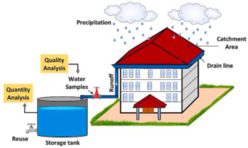
Question 38. Discuss the role of rainwater harvesting in Tamil Nadu.
Answer:
The role of rainwater harvesting in Tamil Nadu
Tamil Nadu plays a very important role in rainwater harvesting in India. It is mandatory to accumulate and store rainwater for every household in the state. The project has been taken up in 2001, and since then it has been found that the groundwater level in Tamil Nadu has risen considerably. Different systems of rainwater collection are implemented in different categories of houses.
The government plays an active role in executing this project and provides the necessary infrastructure—
1. Campaigns regarding the necessity and importance of rainwater harvesting are conducted regularly to increase awareness among the people.
2. Hoardings, banners, festoons, and posters are used to send messages to all corners of the state.
3. Door-to-door surveys and campaigns are conducted regularly.
4. Government aid is provided to set up machinery for harvesting rainwater.
5. The wetlands and brackish lands (about 1821) have been reclaimed and about 6286.84 acres of wetlands have been provided for collecting rainwater.
Chapter 5 India Physical Environment Topic 3 Water Resources Of India Short Answer Type Questions
Question 1. Name three rivers of north and south India each.
Answer:
Rivers of north India—Ganga, Brahmaputra, and Indus. Rivers of south India—Godavari, Krishna, and Kaveri.
Question 2. Where do the sources and mouths of rivers Godavari and Narmada lie?
Answer:
Godavari: The river Godavari rises in the Trimbakeshwar highlands of Western Ghats in the Nashik district of Maharashtra. It meets the Bay of Bengal near Rajahmundry.
Narmada: The river Narmada rises from the Amarkantak plateau lying at the border of Madhya Pradesh and Chhattisgarh. It meets the Gulf of Khambat near Bharuch.
Question 3. Name three west-flowing rivers of India.
Answer:
The west-flowing rivers of India are Narmada, Tapti, and Mahi.
Question 4. Name two tributaries and distributaries each of the river Ganga
Answer:
Tributaries: Rivers Yamuna and Ramganga.
Distributaries: Rivers Bhagirathi-Hooghly and Jalangi.
Question 5. Which rivers of South India make deltas at their mouths?
Answer:
Rivers Godavari, Mahanadi, Krishna, and Kaveri have formed deltas at their mouths.
Question 6. From where does the river Brahmaputra rise? Name its two tributaries.
Answer:
The fiver Brahmaputra rises from the Chemayungdung glacier, 90 km away from the Rakshastal-Manas Sarovar region. Two tributaries of the river Brahmaputra are— Subansiri and Lohit.
Question 7. What is an inland river?
Answer:
Inland river
The rivers that rise in some highlands or mountains and flow into any lake or water body within the land or dry up in the desert region, are called inland rivers. They do not meet any ocean or sea near the boundary of the landmass. Example—The river Luni of Rajasthan rises from the Aravalli hills and ends near the Rann of Kachchh.
Question 8. What are disappearing or influent rivers?
Answer:
Disappearing:
Some rivers may suddenly disappear from the surface and flow through the underground for a certain distance an then once again emerge on the surface in the course of their flow. This may happen if the rivers flow through a limestone region, where the water dissolves the limestone and penetrates deep down. Once the rivers cross the limestone region, they reappear on the surface. These are called disappearing or influent rivers.
Question 9. Name two water divides of India.
Answer:
The two main water divides of India are the Vindhya range and the Western Ghats.
Question 10. Name the right and left bank tributaries of the river Ganga. OR, Name the right bank tributaries of the river Ganga. OR, Name the left bank tributaries of the river Ganga.
Answer:
Right bank tributaries of the river Ganga: Ramganga, Gomti, Ghaghara, Gandak, Kosi. Left bank, tributaries of the river Ganga: Yamuna, Son, Punpun.
Question 11. Which two rivers meet to form the river Ganga and where do they meet?
Answer:
The rivers Bhagirathi and Alaknanda meet at Devaprayag in Uttarakhand to form the river, Ganga.
Question 12. Which rivers meet to form the river Brahmaputra?
Answer:
The rivers Dihang, Dibang, and Lohit meet together to form the river Brahmaputra.
Question 13. Name the only river of Marusthali and mention its source.
Answer:
The only river of Marusthali is the river Luni. It rises from the Aravalli range.
Question 14. Name the most important river of Rajasthan. Where does it meet?
Answer:
The most important river in Rajasthan is Luni. It meets the Rann of Kachchh.
Question 15. Name a few east-flowing rivers of India.
Answer:
Some east-flowing rivers of India are— Mahanadi, Godavari, Krishna, and Kaveri.
Question 16. Name a few tributaries and distributaries of the river Godavari.
Answer:
Tributaries: Rivers Purna, Pranhita, Indravati, Manjira, Pravara, Manair.
Distributaries: Rivers Gautami, Vashishta.
Question 17. Name the main tributary of the river Ganga. Where does it rise?
Answer:
The main tributary of the river Ganga is the river, Yamuna. It rises from the Yamunotri glacier of the Garhwal Himalayas.
Question 18. Name a few cities located on the banks of the river Ganga.
Answer:
Few cities located on the banks of the river Ganga are—Kolkata, Patna, Allahabad, and Kanpur.
Question 19. Name the five tributaries of the river Indus.
Answer:
The five tributaries of the river Indus are— Jhelum, Chenab, Ravi, Beas, and Sutlej.
Question 20. Name two rivers of India that have waterfalls in their courses.
Answer:
The rivers Kaveri (Shivanasamudra falls) and Sharavathi (Gerosoppa falls) have waterfalls in their courses of flow.
Question 21. Name two saltwater lakes in India.
Answer:
Two saltwater lakes of India are— Sambhar lake (Rajasthan) and Pangong lake (Jammu and Kashmir).
Question 22. Where is the source of the river Ganga?
Answer:
The river Ganga rises from the Gomukh cave of the Gangotri glacier, at about an altitude of 4023 m in the Greater Himalayas.
Question 23. Name the highest single-drop waterfall in India. On which river’s course does it lie
Answer:
The highest single-drop waterfall in India is the Gerosoppa waterfall. It lies on the course of the river Sharavathi on the western slope of the Western Ghats.
Question 24. Name two rivers that fall into the Gulf of Khambat.
Answer:
The rivers Narmada and Tapti fall into the Gulf of Khambat.
Question 25. Mention the course of the river Luni.
Answer:
The course of the river Luni
The river Luni is an important river in the desert region of Rajasthan. It starts from the Anasagar lake near Ajmer and ends at the Rann of Kachchh. The length of the river is about 530 km. The river Luni derives its name from the Sanskrit word lavonavari meaning ‘salt river’.
Question 26. Name a few rivers rising from the Western Ghats.
Answer:
The rivers rising from the Western Ghats are—Sharavathi, Ulhas, Netravati, and Savitri.
Question 27. Where do the Indian rivers mainly rise?
Answer:
Most of the rivers of North India rise in the Himalayan mountains. Most of the rivers of South India rise in the Western Ghats.
Question 28. Name the largest riverine island in India and mention its location.
Answer:
The largest riverine island of India is Majuli in the river Brahmaputra. It is located in the Majuli district near Jorhat town of Assam.
Question 29. Name an east-flowing and a west-flowing river in India.
Answer:
An east-flowing river of India is the river Mahanadi. A west-flowing river of India is the river, Narmada.
Question 30. Name some lakes in the Himalayan region.
Answer:
The freshwater lakes present in the Himalayan region are—Nainital, Bhimtal, Sattal, Dal, Wular, etc. Pangong lake is a saltwater lake of the Himalayan region, located in Ladakh.
Question 31. List a few characteristics of the rivers of North India.
Answer:
1. Most of the rivers of north India rise in the Himalayan region.
2. The rivers are perennial, as they are both rainfed as well as snow-fed.
3. The rivers have large basins.
4. The rivers are long and flood-prone in their lower courses.
Question 32. List a few characteristics of the rivers of South India.
Answer:
1. Most of the rivers of South India rise in the Western Ghats and the highlands of Central India.
2. The rivers are nonperennial as they are only rainfed.
3. The rivers are ideal for the generation of hydroelectricity.
Question 33. Name a few rights and left bank tributaries of the river Brahmaputra.
Answer:
Right bank tributaries: Subansiri, Manas, Jia Bharali, Tista, etc.
Left bank tributaries: Kopili, Buri Dihing, Disang, Dikhu, Dhansiri, etc.
Question 34. What is an antecedent river?
Answer:
Antecedent river
The river that maintains its original course with the upheaval of the landmass and building of the mountain chains is called an antecedent river. It maintains its original course despite the upliftment of the land. Some antecedent rivers of India are—Indus, Brahmaputra, Sutlej, Kosi, Subansiri, etc.
Question 35. Why are the Himalayan rivers perennial?
Answer:
The Himalayan rivers are fed with snow melt water as well as rainwater. There is no shortage of water in the channels throughout the year. Hence, they are called perennial rivers.
Question 36. Why do the rivers Narmada and Tapti flow parallel to each other?
Answer:
The rivers Narmada and Tapti flow through the rift valleys between the parallel ranges of the Vindhya and Satpura ranges. Hence, the rivers flow parallel to each other.
Question 37. Why are the rivers of south India more swift flowing than the rivers of North India?
Answer:
The rivers of South India rise from the peninsular ranges and they traverse almost their whole courses over the peninsular plateau region of India. The peninsular plateau region is highly undulating and is made up of hard igneous and metamorphic rocks. Due to the steep slope, the rivers flow more swiftly than the rivers of North India.
Question 38. Why are most of the rivers of India east flowing?
Answer:
The general slope of the landmass in India is from west to east. Hence, the rivers follow the slope and flow eastwards. But the rivers Narmada and Tapti flow through the rift valleys that slope from east to west. Hence, these rivers are west flowing.
Question 39. Why are most of the rivers of South India east flowing?
Answer:
The rivers Mahanadi, Godavari, Krishna, Kaveri, Vaigai, Pennar, etc. rise in the peninsular plateau of South India. The general slope of the land is from west to east. Hence, these rivers flow towards the east and drain into the Bay of Bengal.
Question 40. What is a perennial canal?
Answer:
Perennial canal
A canal dug from a perennial river is called a perennial canal. Such rivers have water throughout the year. Hence, the canals also receive water throughout the year and can be used for irrigating agricultural fields. Example- Western Yamuna canal in Punjab.
Question 41. What is an inundation canal?
Answer:
Inundation canal
The canal which receives water only when the connected river is flooded, is called an inundation canal. In southern India, the rivers are rainfed and tend to dry up during the dry season. At that time the inundation canals also dry up. When the rivers receive rainwater and tend to flood, the canals also receive sufficient water. Example—The delta canal of the river Krishna.
Question 42. Mention the purposes of multipurpose river valley projects.
Answer:
The various purposes of multi-purpose river valley projects are—
1. Flood control,
2. Irrigation,
3. Generation of hydroelectric power,
4. Navigation,
5. Pisciculture,
6. Drinking water,
7. Tourism and others.
Question 43. Which methods of irrigation are seen in India?
Answer:
The methods of irrigation depend upon the topography, soil, climate, rainfall, and groundwater level of a region.
The common methods of irrigation seen in India are—
1. Wells and tube wells,
2. Tanks and
3. Canals
Question 44. Name a few irrigation canals in India.
Answer:
The irrigation canals in India are—The upper Ganga canal, Lower Ganga canal, Sarda canal, Indira Gandhi canal, Medinipur canal, Buckingham canal, etc.
Question 45. What is the Indian Rivers Inter-link Project?
Answer:
The Indian Rivers Inter-link Project
The Indian Rivers Inter-link Project is a proposed large-scale project that aims at linking Indian rivers by a network of reservoirs and canals so as to reduce persistent floods in some parts and water shortages in other parts of India. The project is managed by India’s National Water Development Agency (NWDA) under the aegis of the Ministry of Water Resources.
Question 46. What is the relation between the water-holding capacity of soil and irrigation?
Answer:
The type of soil present in a region is one of the factors determining the irrigation requirement of the region. Sandy and loamy soils have less water-holding capacities.
Hence, they require more irrigation water for agriculture. Alluvial soils have moderate to high water-holding capacity and require irrigation according to the crop cultivated. On the other hand, black soil and clayey soils can hold water for a long time. Hence, they require less irrigation water for agriculture.
Question 47. What are the sources of irrigation in India?
Answer:
The sources of irrigation in India
The main sources of water for irrigation in India are—flowing water, stored water, and groundwater. Canals are dug from flowing as well as stored water. Groundwater is utilized by pumping out through wells and tube wells. Then, water is spread onto the agricultural fields as and when needed.
Question 48. Name the states of India where well and tube well irrigation is popular.
Answer:
Well and tube well irrigation is popular in India in Uttar Pradesh, Punjab, Rajasthan, Bihar, Gujarat, Maharashtra, Andhra Pradesh, and West Bengal.
Question 49. Name two irrigation projects taken up in West Bengal.
Answer:
The two irrigation projects taken up in West Bengal are Damodar Valley Project on the river Damodar and the Mayurakshi project on the river Mayurakshi.
Question 50. What are the effects of excessive use of groundwater?
Answer:
Excessive use of groundwater tends to increase the amount of arsenic in the groundwater. It increases the salinity of the soil, lowers the water table, and may even lead to the subsidence of land.
Question 51. Mention the various methods of conservation of water.
Answer:
The various methods of conservation of water are—
1. Use of modern and scientific technologies in the conservation of water.
2. Reduce water pollution.
3. Development of watershed management.
4. Rainwater harvesting and conservation of rainwater.
5. Purification and reuse of water.
Question 52. How can rainwater be harvested or collected?
Answer:
Rainwater can be harvested or collected by two methods—
1. Store the flowing water or runoff in reservoirs.
2. Collect rainwater on the roof of houses and buildings.
Question 53. Mention two purposes of rainwater harvesting.
Answer:
Two purposes of rainwater harvesting are—
1. To increase groundwater reserves.
2. To increase the water reserve for irrigation by storing the rainwater during the rainy season.
Chapter 5 India Physical Environment Topic 3 Water Resources Of India Multiple Choice Type Questions
Write The Correct Answer From The Given Alternatives
Question 1. The water divide between the rivers of North and South India is the—
- Himalayan range
- Vindhya range
- Western Ghats
- Eastern Ghats
Answer: 2. Vindhya range
Question 2. The river Alaknanda meets the river Bhagirathi at—
- Allahabad
- Devaprayag
- Patna
- Kolkata
Answer: 2. Devaprayag
Question 3. The main tributary of the river Ganga is—
- Alaknanda
- Bhagirathi
- Yamuna
- Sabarmati
Answer: 3. Yamuna
Question 4. The river Indus rises from the glacier.
- Senge Khabab
- Manas Sarovar
- Chemayungdung
- Zemu
Answer: 1. Senge Khabab
Question 5. The river Brahmaputra is known as the Tsangpo in—
- Tibet
- India
- Nepal
- Bhutan
Answer: 1. Tibet
Question 6. The main river of Rajasthan is—
- Luni
- Sabarmati
- Mahi
- Saraswati
Answer: 1. Luni
Question 7. The river Luni meets the—
- Gulf of Kachchh
- Rann of Kachchh
- Gulf of Khambat
- Gulf of Mannar
Answer: 2. Rann of Kachchh
Question 8. The Hundru falls lies on the course of the river—
- Subarnarekha
- Damodar
- Mahanadi
- Tapi
Answer: 1. Subarnarekha
Question 9. The Shivasamudram falls is on the course of a river—
- Sabarmati
- Krishna
- Kaveri
- Mahanadi
Answer: 3. Kaveri
Question 10. Which of the following is a freshwater lake?
- Pushkar
- Wular
- Sambhar
- Chilka
Answer: Wular
Question 11. is a lake in the Himalayan region.
- Chilka
- Roopkund
- Loktak
- Kolleru
Answer: Roopkund
Question 12. Which of the following river rises in the Trimbakeshawar highland?
- Godavari
- Krishna
- Kaveri
- Vaigai
Answer: 1. Godavari
Question 13. The river rises in the Aravalli range.
- Mahi
- Kaveri
- Luni
- Krishna
Answer: 3. Luni
Question 14. The river Yamuna meets the river Ganga near—
- Allahabad
- Patna
- Haridwar
- Lucknow
Answer: 1. Allahabad
Question 15. Gerosoppa falls or Jog falls is on the course of the river—
- Sharavathi
- Sabarmati
- Netravati
- Narmada
Answer: 1. Sharavathi
Question 16. The combined flow of the rivers Dihang, Dibang, and Lohit is known as—
- Brahmaputra
- Yamuna
- Tsangpo
- Dhansiri
Answer: 1. Brahmaputra
Question 17. The largest river basin in India is the basin of the river—
- Ganga
- Brahmaputra
- Indus
- Godavari
Answer: 1. Ganga
Question 18. Which of the following river is a tributary of the Indus?
- Chambal
- Tista
- Yamuna
- Chenab
Answer: 4. Chenab
Question 19. The river Alaknanda rises from the glacier.
- Gangotri
- Yamunotri
- Satopanth
- Zemu
Answer: 3. Satopanth
Question 20. The longest tributary of river Yamuna is a river—
- Chambal
- Tons
- Beas
- Son
Answer: 2. Tons
Question 21. The city of Goalpara lies on the bank of the river—
- Ganga
- Brahmaputra
- Indus
- Mahanadi
Answer: 2. Brahmaputra
Question 22. The Indian lake has a floating market.
- Wular
- Dal
- Loktak
- Sambhar
Answer: 2. Dal
Question 23. An example of a crater lake in India is —
- Lonar in Maharashtra
- Sambhar in Rajasthan
- Pulicat in Tamil Nadu
- Dal in Jammu and Kashmir
Answer: 1. Lonar in Maharashtra
Question 24. A saltwater lake in north India is—
- Dal lake
- Wular lake
- Pangong lake
- Nainital
Answer: 3. Pangong lake
Question 25. The river Godavari is known as the ‘Ganga of South India’ because—
- It is the longest river in South India
- It is an important river in South India
- It is a holy river
- All of the above
Answer: 4. All of the above
Question 26. The city of Lucknow lies on the banks of the river—
- Sabarmati
- Gomti
- Kosi
- Ghaghara
Answer: 4. Ghaghara
Question 27. The river Narmada is also known as—
- Lohit
- Tsangpo
- Rewa
- Hiran
Answer: 3. Rewa
Question 28. The river Brahmaputra enters India as river Dihang in—
- Assam
- Meghalaya
- Arunachal Pradesh
- Nagaland
Answer: 3. Arunachal Pradesh
Question 29. The largest lagoon in Asia is—
- Vembanad
- Pulicat
- Chilka
- Dal
Answer: 3. Chilka
Question 30. The river is a west-flowing river in India.
- Son
- Godavari
- Krishna
- Tapi
Answer: 4. Tapi
Question 31. The most popular means of irrigation practiced in India is—
- Well and tube well
- Tank
- Canal
- Sprinkler
Answer: 3. Canal
Question 32. Irrigation facilities are most developed in—
- Punjab
- West Bengal
- Uttar Pradesh
- Rajasthan
Answer: 3. Uttar Pradesh
Question 33. A river on which a multi-purpose project has been built is—
- Rupnarayan
- Mahananda
- Damodar
- Tista
Answer: 3. Damodar
Question 34. The dam constructed only for the purpose of irrigation is called—
- Irrigation dam
- Natural lake
- Multi-purpose dam
- Natural dam
Answer: 1. Irrigation dam
Question 35. The country possessing the maximum amount of irrigated land is—
- India
- China
- Russia
- USA
Answer: 1. India
Question 36. Excessive irrigation—
- Increases soil fertility
- Increases humification
- Increases salinity of soil
- Soothes the soil
Answer: 3. Increases salinity of soil
Question 37. The irrigation dams constructed in the Mayurakshi Project are at Massanjore and—
- Bhakra
- Nangal
- Kangsabati
- Tilpara
Answer: 4. Tilpara
Question 38. The first multi-purpose river valley project of India is the—
- Bhakra-Nangal project
- Damodar Valley project
- Tista Project
- Nagarjuna project
Answer: 2. Damodar Valley project
Question 39. The second largest irrigation canal in India is the—
- East Yamuna canal
- West Yamuna canal
- Sarda canal
- Indira Gandhi canal
Answer: 3. Sarda canal
Question 40. The source of water for well or tube well irrigation is—
- Flowing water
- Stored water
- Groundwater
- Ocean water
Answer: 2. Stored water
Question 41. The maximum number of inundation canals are found in—
- Northern India
- Eastern India
- Southern India
- Western India
Answer: 3. Southern India
Question 42. The Bhakra dam has been constructed on the river—
- Sutlej
- Beas
- Chenab
- Indus
Answer: 1. Sutlej
Question 43. An important irrigation canal in Rajasthan is the—
- Indira Gandhi canal
- Betwa canal
- Chausa canal
- Bishnupur canal
Answer: 2. Betwa canal
Question 44. Draining out excessive water through tube wells may cause—
- Soil pollution
- Arsenic pollution
- Air pollution
- Sound pollution
Answer: 2. Arsenic pollution
Question 45. An important method of conservation of water is—
- Watershed management
- Not using water
- Re-use of water
- Cultivation in wetlands
Answer: 1. Watershed management
Question 46. Rainwater harvesting in India is mandatory in the state of—
- West Bengal
- Tamil Nadu
- Kerala
- Andhra Pradesh
Answer: 2. Tamil Nadu
Question 47. Which of the following is necessary for meeting the excessive demand for water?
- Watershed management
- Rainwater harvesting
- Constructing canals
- Storing snow-melt water
Answer: 2. Rainwater harvesting
Question 48. Rainwater harvesting helps to—
- Attract rainfall
- Reduce soil erosion
- Conserve the Ecosystem
- Recharge groundwater
Answer: 4. Recharge groundwater
Chapter 5 India Physical Environment Topic 3 Water Resources Of India If The Statement Is True, Write True And If False Write False Against The Following
Question 1. Subansiri is a tributary of the river Brahmaputra
Answer: True
Question 2. River Luni of India is an east-flowing river.
Answer: True
Question 3. Luni is an inland river in India.
Answer: True
Question 4. Chilka is a lagoon on the eastern coast of India.
Answer: True
Question 5. Jog falls lies on the course of river Luni.
Answer: False
Question 6. The river Indus rises from the Manas Sarovar.
Answer: False
Question 7. The river Brahmaputra flows into the Arabian Sea.
Answer: False
Question 8. The main branch of the river Ganga flows through Bangladesh as river Bhagirathi- Hooghly.
Answer: False
Question 9. The west-flowing river Godavari creates a waterfall at its mouth.
Answer: False
Question 10. The rivers of south India are mostly rainfed.
Answer: True
Question 11. The Vindhya range acts as a water divide between the rivers of North and South India.
Answer: True
Question 12. The river Shyok is a tributary of the river Indus.
Answer: True
Question 13. The middle course the of river Ganga extends between Haridwar and the Rajmahal hills.
Answer: True
Question 14. The river Brahmaputra rises from the Yangtse glacier in Tibet and flows into the Arabian Sea.
Answer: False
Question 15. The river Sankosh is a distributary of the river Brahmaputra.
Answer: False
Question 16. The Gangetic delta is the largest delta in the world.
Answer: True
Question 17. Vembanad is the largest lagoon in India.
Answer: False
Question 18. Mahanadi river rises in the highlands of Odisha.
Answer: False
Question 19. The river Chambal is a tributary of the river Yamuna.
Answer: False
Question 20. The rivers of South India are perennial.
Answer: False
Question 21. The River Tennessee is a tributary of the river Ganga
Answer: False
Question 22. The rivers of South India are navigable.
Answer: False
Question 23. Hyderabad is located on the banks of the river Musi, a tributary of the river Krishna.
Answer: True
Question 24. The river Kaveri is an inland river in India.
Answer: False
Question 25. The rivers Kaveri and Godavari are west-flowing rivers of India.
Answer: False
Question 26. The rivers Koyna and Ghataprabha meet with the river Krishna.
Answer: True
Question 27. The river Brahmaputra of Assam is flood-prone in nature.
Answer: True
Question 28. The rivers of South India often change their courses.
Answer: False
Question 29. The Medinipur canal is a perennial canal of West Bengal.
Answer: True
Question 30. The river Indus has been dammed in the Hirakud project.
Answer: False
Question 31. The Maithon dam and reservoir have been constructed on the Damodar river.
Answer: False
Question 32. The Bhakra dam has been constructed on the river Sutlej.
Answer: True
Question 33. The Indira Gandhi canal is a famous irrigation canal in India.
Answer: True
Chapter 5 Indian-Physical Environment Topic 3 Water Resources Of India Fill In The Blanks With Suitable Words
Question 1. The river_______flows through the Kashmir Valley.
Answer: Jhelum
Question 2. The_______ is the main river flowing through north-west India.
Answer: Indus
Question 3. The main river of north-east India is_______
Answer: Brahmaputra
Question 4. The _______Indus civilization grew on the banks of the river
Answer: Indus
Question 5. The river Sabarmati rises in the_______ hills.
Answer: Aravalli
Question 6. The Narmada is a_______ river.
Answer: West flowing
Question 7. _______is an important tributary of the river Kaveri.
Answer: Bhavani
Question 8. One tributary of the river Indus flowing through Punjab is _______
Answer: Sutlej
Question 9. The river Brahmaputra is known as_______ in Arunachal Pradesh.
Answer: Dihang
Question 10. The river_______ is the chief tributary of the river Tapti.
Answer: Purna
Question 11. The river _______ rises near Multai in the Satpura hills.
Answer: Tapti
Question 12. The _______ is the longest west-flowing river in India.
Answer: Narmada
Question 13. The river Narmada rises from _______ plateau.
Answer: Amarkantak
Question 14. The river Brahmaputra is known as Tsangpo in _______
Answer: Amarkantak Id. Tlhot
Question 15. _______ is the highest single-drop waterfall in India.
Answer: Jon calls
Question 16. The river Tungabhadra is a tributary of the river _______
Answer: Krishna
Question 17. The island of Srirangapatna lies at the mouth of the river _______
Answer: Kavti
Question 18. Ahmedabad lies on the banks of the river_______
Answer: Sabarmatl
Question 19. _______ is a tributary of the river Brahmaputra which runs through Bhutan.
Answer: Manas
Question 20. The river Narmada meets the _______
Answer: Gulf of Khambal
Question 21. The river Mahanadi rises in the _______ range of Chhattisgarh.
Answer: Slhawa
Question 22. The river _______ is a large river in northeast India.
Answer: Brahmaputra
Question 23. The lakes in Uttarakhand are called _______
Answer: Tnl
Question 24. The _______ lake lies in between the delta of the rivers Krishna and Godavari.
Answer: Kolloru
Question 25. The lagoons on the Malabar coast are known as _______
Answer: Kayals
Question 26. The river Sabari is a tributary of the river_______
Answer: Godavari
Question 27. The Loktak lake is located in _______
Answer: Manipur
Question 28. Bhagirathi and _______ river meet at Devaprayag to form the river Ganga.
Answer: Alaknanda
Question 29. The _______ multipurpose river valley project is a famous river valley project in the northwestern part of India.
Answer: Bhnkra-Nangnl
Question 30. _______ irrigation is more popular in southern India.
Answer: Tank
Question 31. The canals which can be used for irrigation only when the rivers are flooded are called _______ canals.
Answer: Inundation
Question 32. The Damodar Valley Project has been built following the _______ project.
Answer: Tennessee Valley
Question 33. Water is collected from the _______ of the mountains in the development and management of the watershed.
Answer: Pool hills
Chapter 5 Indian-Physical Environment Topic 3 Water Resources Of India Answer In One Or Two Words
Question 1. Name the longest tributary of the river Ganga
Answer: Kivor Yamuna.
Question 2. What is the combined flow of the rivers Bhagirathi and Alaknanda known as?
Answer: River Ganga.
Question 3. Name two east-flowing rivers of India.
Answer: Rivers Godavari and Krishna.
Question 4. What is the combined flow of the rivers Dwarakcshwar and Silabati (Silai) known as?
Answer: River Rupnarayan.
Question 5. On which river have the Bhakra and Nangal dams been constructed?
Answer: River Sutlej.
Question 6. Name a left-bank tributary of the river Ganga.
Answer: River Gomtl
Question 7. Name one of the holy rivers of South India.
Answer: River Koverl.
Question 8. Which is the highest single-drop waterfall in India?
Answer: Jog or Gerosoppa falls.
Question 9. Where is the river Brahmaputra known as Tsangpo?
Answer: Tibet.
Question 10. Name a waterfall on the river Kaveri.
Answer: Shlvasnmudram.
Question 11. Which river is known as the ‘Ganga of South India’?
Answer: River Godavari.
Question 12. Name a city located on the banks of the river Tapti.
Answer: Surat.
Question 13. What is the river Brahmaputra known as in Bangladesh?
Answer: River Jamuna.
Question 14. Where does the river Ganga enter West Bengal?
Answer: South of Rajmahal hills.
Question 15. Name a tributary of the river Yamuna.
Answer: River Tons.
Question 16. From which place onward is the river Brahmaputra known as the river Jamuna?
Answer: Dhubri in Assam.
Question 17. From where does the river Narmada rise?
Answer: Amarkantak plateau.
Question 18. Between which mountains does the river Narmada flow?
Answer: Through the rift valley between the Vindhya and the Satpura ranges.
Question 19. Name a freshwater lake in India.
Answer: Dal lake.
Question 20. Name the holy lake in Manipur.
Answer: Loktak lake.
Question 21. Name the famous waterfall on the river Narmada.
Answer: Dhuandhar.
Question 22. Where is irrigation through perennial canals practiced in India?
Answer: Northern India.
Question 23. Where is the Eden canal located?
Answer: West Bengal.
Question 24. Name an important irrigation dam in eastern India.
Answer: Hlrakud darn.
Question 25. What are the canals that are used for irrigation throughout the year called?
Answer: Perennial canals.
26. Which state of India has the maximum amount of irrigated agricultural land?
Answer: Punjab.
27. Name the multi-purpose river valley project built on the river Krishna.
Answer: Nagarjuna Sagar.
28. Which one is the longest river in South India?
Answer: Godavari.
29. Name the common multipurpose river valley project of the states of Jharkhand and West Bengal.
Answer: Damodar Valley Project.
Chapter 5 Indian-Physical Environment Topic 3 Water Resources Of India Match The Left Column With The Right Column
1.
| Left Column |
Right Column |
| 1. Narmada |
A. Shivasamudram waterfall |
| 2. Sharavathi |
B. Dhuandhar falls |
| 3. Kaveri |
C. Jog falls |
| 4. Subarnarekha |
D. Hundru falls |
| 5. Tapti |
E. Multai Hills |
Answer: 1-C,2-D,3-E,4-A,5-B
2.
| Left Column |
Right Column |
| 1. Vembanad |
A. Playa |
| 2. Sambhar |
B. Tamil Nadu |
| 3. Chilka |
C. Between Krishna and Godavari deltas |
| 4. Kolleru |
D. Malabar coast |
| 5. Pulicat |
E. Odisha coast |
Answer: 1-B,2-C,3-A,4-D,5-E
3.
| Left Column |
Right Column |
| 1. Yamuna |
A. Indus |
| 2. Beas |
B. Dwarka |
| 3. Manas |
C. Kaveri |
| 4. Brahmani |
D. Ganga |
| 5. Amaravati |
E. Brahmaputra |
Answer: 1-D,2-A,3-E,4-C,5-B
4.
| Left Column |
Right Column |
| 1. Ganga |
A. South Indian river |
| 2. Brahmaputra |
B. Inland river |
| 3. Sharavathi |
C. Bhagirathi-Hooghly |
| 4. Godavari |
D. Chemayungdung glacier |
| 5. Luni |
E. Gerosoppa falls |
Answer: 1-D,2-A,3-E,4-B,5-C