
WBBSE Chapter 11 Continent Of Europe Topic D Polderland Long Question And Answers
Question 1. How is a Polderland formed? Discuss with diagram.
Answer:
Formation of Polderland:
The mechanism of reclaiming the shallow part of the sea or creating a Polderland is completed in five stages, such as-
1. Land consolidation with concrete dams:
In the first stage, the shallow part of the sea is bounded by reinforced and wide concrete dams. A ring canal is cut inside the dam in such a way that water from the enclosed area can be pumped into the canal and finally can be emptied into the sea.
2. Filling by mud-water:
This wetland is then filled with mud water with the help of a pump (formerly done by a windmill).
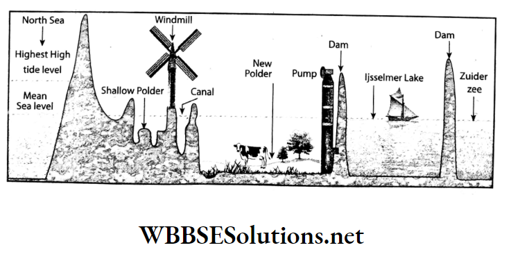
3. Drainage with the help of a pump:
In the third stage, when the mud stagnates at the bottom of the wetland, the water is pumped out into the sea through ring canals.
Read And Learn Also WBBSE Solutions For Class 7 Geography
4. Cultivation of grass-like fodder:
In the fourth stage, the land is left for several years to reduce the salinity of the soil. Alfalfa, hay, clover, etc. grasses which are used as fodder, are cultivated to make the land suitable for agriculture.
5. Cultivation of crops and flowers:
Finally, different types of crops like wheat, barley, beet, oat, etc., and different types of flowers like sunflower, tulip, cosmos, gladioli, etc. are cultivated when the land is suitable for agriculture.
Thus the land recovered from the sea becomes usable in a few years.

Question 2. Where are the polders concentrated in the continent of Europe?
Answer:
Polders concentrated in the continent of Europe:
- Most of the polders in Europe are within the political boundary of the Netherlands. Almost 40 per cent of the total land area of the Netherlands is polders.
- The team ‘Polderland’ means land reclaimed from the sea.
- In the northwest of the Netherlands, in the shallow part of the Gulf of Zuider Zee, the vast lowlands that have been recovered by removing seawater with concrete dams are called ‘polder land’.
- To the north and west of the polders lie the North Sea and Belgium. Its area is variable.
Question 3. What are the special characteristics of the topography of the Polderland?
Answer:
The special characteristics of the topography of the Polderland are as follows-
- Though the Polderland are extensive plain lands, because of their average elevation being below sea level, they are classified as lowlands.
- The Polderland are protected by concrete dykes-in case these dykes collapse, the polders will be reclaimed by the sea. So, during times of rainfall, the water that accumulates in the polder land are constantly pumped out and carried away by canals.
- About 90 percent of the Polderland is about 2 to 3 metres below sea level.
- The polders are plains with a lot of swamps, marshes, and primarily clayey soil.
- The northeastern part of the Polderland is known as Groningen, the south and south-eastern parts are called Zeeland and the portion between Groningen and Zeeland is known as Middleland.
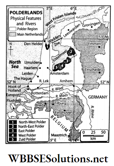
Question 4. Classify the polders into physical regions.
Answer:
According to the topography, the polders can be classified into three regions-
- Groningen,
- Middleland and
- Zuid Holland.
1. Groningen:
- The northern and northeastern parts of the polders are called Groningen Friesland and Overijssel.
- This region is below the sea level.
2. Middleland:
- The west and central part of the polders of the Netherlands covering Noord Holland and Dordrecht is known as Middleland.
- The elevation of this region is slightly lower than the sea level.
3. Zuid Holland:
- This is the southern part of the polders.
- The elevation of this region is the same as the sea level.
Question 5. Write about the climate of the Polderland.
Answer:
The features of the climate of the Polderlands are as follows-
- Effect of warm ocean current: Though the polder land are located in the cold temperate zone but the influence of the warm North Atlantic current makes the climate moderate.
- Temperature: Winters are moderately cold with an average temperature of 3°C. Summers are also moderate, with an average temperature of about 16°C.
- Rainfall: The moisture-laden southwest westerly winds bring rainfall to this region throughout the year. The average annual rainfall is about 70 cm.
- Type: This climate type is characterised as the Western Coastal Marine Climate Type or the British Isles Climate Type.
Understanding Polderland in the Netherlands
Question 6. Mention the economic environment of the Polderland.
Answer:
The economic environment of the Polderland is as follows-
1. Agriculture and animal husbandry:
- Vegetables like wheat, oat, barley, beet, potato etc. and flowers like tulips, cosmos, sunflower, gladioli etc. are cultivated in the salt-free agricultural land of Polderland.
- Grasslands are used for extensive animal husbandry. Cultivation in greenhouses in cool and less-lit areas is also done here.
2. Mineral resources:
- Polderland is not rich in mineral resources.
- The Groningen region and The Hague are rich in natural gas and petroleum respectively.
3. Transportation system:
- The transportation system of Polderland is well-developed.
- Ring canals are also used for transportation.
4. Industry:
- Polderland is very advanced in the industry. Different industries have been developed in the cities of Amsterdam, Rotterdam, Groningen, The Hague, Flushing etc.
- In addition, Amsterdam is world-famous for the diamond cutting and polishing industry.
Question 7. What are the special features of the agriculture of the Polderland? Or, Mention two main farming practices of the Polderland.
Answer:
Agriculture in the Polderland is carried out in two main ways-
1. Mixed-type farming:
This type of agricultural practice requires skilled farmers, the use of advanced technology and certain other factors-all of which are available in the Netherlands. As a result, this type of farming is prevalent and is also commercially viable.
2. Greenhouse farming:
Vegetables and greens are grown in greenhouses in areas where the temperatures are low and the sun rays always fall obliquely.
Question 8. What are the agricultural products of the Polderland?
Answer:
The main agricultural products of the Polderland are as follows-
1. Animal fodder:
To reduce the salinity of the soil, crops such as hay, clover and alfalfa are grown on newly reclaimed soil.
2. Food crops:
Once the salinity of the soil has been reduced, the soil becomes very fertile and yields high-quality food crops like wheat, oat, barley, potato, mustard and so on. Animal rearing is also done here.
3. Flowers:
Flowers such as tulips, cosmos, gladiolus, and daffodils are cultivated on huge tracts of land here. These are sold in other parts of the world. So, flowers are an important cash crop for the farmers of this region.
Question 9. Explain why agriculture is done with the help of greenhouses in polderland.
Answer:
Agriculture is done with the help of greenhouses in polder land:
- The polders of the Netherlands lie in the cold temperate region that comes under the British Isles climatic type. As the summer temperature of the region is 16°C and the winter temperature is an average of 3°C, the region is always cool.
- In this type of climate, nothing grows well apart from wheat, beet, cabbage and a few other crops. So, greenhouses are used to regulate the temperature and grow grapes, cucumbers, melons and such other fruits.
Question 10. What are the mineral resources and industries in the Polderland?
Answer:
Mineral resources and industries in the Polderland:
- The main mineral resource of the Polderland is natural gas. Groningen, situated in the northeast of the polder land, is the main area from where large quantities of natural gas is extracted.
- The region near the Hague is rich in mineral oil. Several industries have also grown and developed in this region.
These are-
- Electronics and electrical (the world-famous Philips company is from this area)
- Petro-chemicals,
- ship-building,
- Dairy,
- Food processing,
- Weaving,
- paper,
- Leather,
- Cosmetics,
- Iron and steel.
Amsterdam, Rotterdam and The Hague are the main centres of industry.
Question 11. Explain why dairy farming is highly developed in the polders of the Netherlands.
Answer:
Dairy farming is highly developed in the polders of the Netherlands. The Netherlands holds the third position in the production of milk powder and the fifth position in producing cheese in the world.
The reasons for the development of dairy farming in the Netherlands are as follows-
- Large production of fodder (hay, clover, and alfalfa) and mixed farming,
- Temperate climate,
- Technological development,
- Highly-developed transport facility,
- Developed species of cows (Holstein and Fregean) are reared,
- Proper investment for animal rearing. Adam of Alkmaar is a popular city of dairy farming in the polders of the Netherlands.
Question 12. Explain why the leather and textile industry is highly developed in the Netherlands.
Answer:
The reasons for the development of the leather industry in the Netherlands are as follows-
- Large production of fodder (hay, clover, and alfalfa) and mixed farming,
- Temperate climate,
- Rearing of cattle such as sheep, buffalo, pigs, and cow in large numbers,
- Proper investment for animal rearing,
- Highly-developed transport facility,
- Technological development,
- Skilled labors.
On the other hand, the reasons for the development of the textile industry in the Netherlands are as follows-
- The large demand for wool because of the cool climate,
- Improved technology,
- A large stretch of grazing land,
- Proper investment,
- Skilled laborers etc.
Question 13. What are the reasons for the high rate of industrial development of the polders of the Netherlands?
Answer:
The main reasons for the high rate of industrial development in the polders of the Netherlands are as follows-
- The plentiful supply of raw materials for agro-based industries,
- Supply of natural gas mineral oil and animal-based products,
- Well-developed transport systems,
- Highly developed logistic systems,
- Skilled labors,
- Superior administrative capacity,
- The ease of import-export through ports such as Amsterdam and Rotterdam,
- Active initiatives and support from the government.
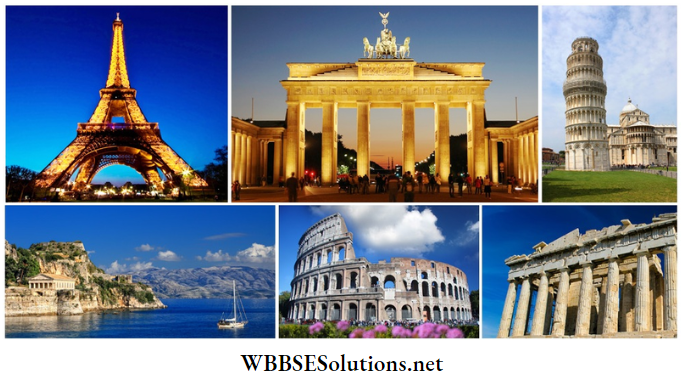
Question 1.4 Create a collage with various sightseeing spots of Europe.
Answer:
WBBSE Chapter 11 Continent Of Europe Topic D Polderland Short Question And Answers
Question 1. What is Polderland?
Answer:
Polderland:
The term ‘Polder’ means low plains recovered from the sea. The low-lying plains created through filling and making dams in the shallow seas of the Netherlands in north-western Europe to give rise to usable lands are known as Polderlands.
For example-Zuider Zee polder, Zeeland polder, Anna Paulowna polder, Prince Alexander polder etc.
Question 2. What is Zuider Zee Project in Holland?
Answer:
Zuider Zee Project in Holland:
- The Zuider Zee project in the largest Polderland in Holland or the Netherlands.
- Under this project, hundreds of square kilometers have been reclaimed at various stages from a lake called the Ijsselmeer, which was created behind the dam at the mouth of Zuider Zee Bay.
Question 3. Write about the rivers of the Borderlands.
Answer:
The rivers of the Borderlands:
- The main river of the Polderlands is the Rhine
- Apart from this, some distributaries such as Lake and Waal also contribute to the riverine network.
- Another river by the name of Maas flows through this region.
Question 4. What is the nature of the soil in the Borderlands?
Answer:
Nature of the soil in the Borderlands:
- Soils of the polders consist mainly of sea clay and bog peat. This has high sand content. On the banks of the rivers Rhine, Waal and Lake, we can also find some clayey soil.
- Though the soil of the polders is saline at first, with rainfall and the cultivation of animal fodder, it is desalinated and made highly fertile.
Question 5. Explain why Amsterdam is famous.
Answer:
Amsterdam is famous:
Amsterdam is the capital of the Netherlands and one of the most important ports and industrial centres.
- Apart from its industrial and administrative importance, Amsterdam is also famous for its natural beauty.
- It is called the ‘Venice of the North’. Its canals, the Van Gogh Museum, and Anne Frank House are all special attractions for tourists.
- Amsterdam is famous worldwide for its engineering industry, electronics, petrochemical and diamond-cutting and polishing factories.
Question 6. Write a short note on the Netherlands.
Answer:
Netherlands:
- The country of the Netherlands is situated in the northwest of Europe and is very small in size. In the Netherlands, land availability was inadequate for agriculture or even to carry out basic trade and commerce.
- So, as part of a reclamation initiative, huge chunks of concrete were used to build a dyke and keep away the sea at the Zuider Zee Gulf which lies to the north-largest city in the Netherlands. Maritime and West.
- The plain land that was reclaimed from the sea is known as polder land and the Polderland constitutes about 40 percent of the land area of the Netherlands. The Netherlands is famous worldwide for its flowers and dairy products.
Question 7. Write a brief note on The Hague.
Answer:
The Hague:
- The Hague came into prominence as the administrative centre for the nation of Holland in about the year 1580. This is a cosmopolitan city and the Supreme Court of the Netherlands, and the International Court of Justice have their offices here.
- Organizations involved in the chemical, glass, printing, metallurgy, and food-processing industries have a strong presence here.
Question 8. Write a short note on the Port of Rotterdam.
Answer:
Port of Rotterdam:
- The port of Rotterdam, situated on the estuary of the river Lake, is the largest in Europe and the busiest in the world. Apart from the Netherlands, goods for the rest of Europe are also imported and exported from here.
- So, it is also called Europort. Rotterdam is the second largest city in the Netherlands. Maritime and Volkenkunde Museums, Erasmus Bridge, and Euromast are some tourist spots in the city.
- Consumer goods giant, Unilever, and Steel giant, Aarcelormittal are among the global enterprises to have a significant presence in the city.
Question 9. Write the names of the main industrial centres of the Polderland.
Answer:
Most of the industries have their centers of the Polderland in the following regions-
- Leiden
- Rotter-dam,
- Groningen,
- Haarlem,
- Amsterdam,
- UJmuiden,
- Utrecht,
- Delft,
- The Hague,
- Flushing,
- Den Helder.
Question 10. Name the main bays and the main peninsulas which are situated at the boundaries of Europe.
Answer:
- The main bays which lie on the boundaries of the continent of Europe are the Gulf of Lion, the Gulf of Finland, the Bay of Riga, Genoa Bay, the Bay of Biscay, the Gulf of Bothnia.
- The main peninsulas are- the Balkan peninsula, the Crimean Peninsula, the Italian Peninsula, Scandinavian Peninsula.
Question 11. What are the features of the distribution of population in Europe?
Answer:
Europe is the third most populous continent in Europe. According to 2018 statistics, the total population of Europe is about 746.42 million – about 11% of the world’s total population.
The mention-worthy characteristics of the distribution of the population of this continent are as follows-
- There are about 56 sovereign nations within the continent of Europe but more than half of the total population lives across just seven countries. These countries are Germany (84 million), France (65 million), the U.K. (68 million), Italy (61 million), Ukraine (44 million), Spain (47 million), and Poland (38 million).
- The western and southern parts of the continent are more populated.
- Russia is the largest country in the world in terms of area and is home to about 146 million people but most of this population is concentrated in the part of Russia that is in the continent of Asia.
Question 12. What is the contribution of the River Thames to the development of the port of London?
Answer:
The ways in which the River Thames has contributed to the development of the Port of London are as follows-
- Wide river mouth: This river has formed several estuaries and creeks at its mouth before discharging into the North Sea. Since a delta has not formed, the creeks are wide and large ships can easily sail into the port of London.
- Deep river bed: The river Thames is quite deep. As a result, medium-sized ships face no difficulty in reaching the port of London which is at a distance of 49 kilometers from the mouth of the river.
- Easy navigable: The water of the river Thames does not freeze even in winter. As a result, the river remains accessible and navigable throughout the year.
Question 13. Write what you know about animal rearing in the polders.
Answer:
- Just as with agriculture, animal rearing in the Netherlands is also very well-developed and uses the latest technology. Animal fodders like hay, clover, and alfalfa are cultivated extensively in this region and cattle are reared.
- The advanced agricultural and animal-rearing processes and practices lead to the production of high amounts of premium-quality milk and dairy products such as butter, evaporated milk, cheese, cottage cheese, and yogurt which are quite famous.
- Apart from dairy, poultry and pig farming is also carried out in this region for commercial purposes. Groningen is famous for animal rearing.
Question 14. Why is the coastline of Europe so long though it is such a small continent in the area?
Answer:
- Europe is bounded on the north by the Arctic Ocean, on the south by the Mediterranean Sea and the Black Sea, and on the west by the Atlantic Ocean and the North Sea.
- Since it is bounded by the sea on three sides, it has a long coastline irrespective of its small land area. The length of the coastline of Europe is about 38000 kilometers.
Question 15. How were the British Isles formed?
Answer:
- According to geologists, at one point the British Isles were attached to the mainland of Europe. When a part of the land subsided, the sea rushed over the submerged land that was then created.
- The parts that were isolated yet visible above sea level by this body of water- formed the islands. The depositional activity of the oceans has also resulted in the formation of several islands.
Question 16. Write a short note on Baltic Shield.
Answer:
Baltic Shield:
- According to geologic time, the North-West Highlands of Europe are very ancient and most of it have been formed from ancient igneous and metamorphic rocks.
- The ancient, low plateau region that extends across parts of Sweden and Finland along the coast of the Baltic Sea, is known as the Baltic Shield.
- This is actually a separated plateau and is made of rock that is quite immune to the forces of erosion.
Real-Life Scenarios Involving Flood Control in Polderland
Question 17. What is a fjord?
Answer:
Fjord:
- The numerous, long, narrow inlets of water with steep sides that are seen in Norway and Sweden are known as fjords. These formed in the Ice Age due to glacial erosion.
- At first narrow valleys were formed and when the glaciers melted, they were filled with water from the sea.
Question 18. Briefly describe the lakes of Europe.
Answer:
Europe has numerous lakes – both big and small. These are-
1. Alpine lakes:
In the Swiss Alps, lakes like Geneva, Zurich, and Lucerne, the Garda, Como, and Magyar lakes in northern Italy, in England, the Ullswater and Windermere lakes and Loch Lomond in Scotland are other famous alpine lakes.
2. Lakes of the plains:
- Ladoga and Onega lakes in north-west Russia are lakes which are situated in the plains. Lake Ladoga, with an area of 17,700 sq. km., is the largest lake in Europe.
- Lake Saimaa in Finland, Vanern and Vattern Lakes in Sweden, and Balaton Lake in Hungary are other lakes which are situated in the plains in Europe.
WBBSE Chapter 11 Continent Of Europe Topic D Polderland Very Short Question And Answers
Question 1. What is the name given to the land recovered from the sea in Europe?
Answer: Polderland.
Question 2. What is the name given to the initiative that set out to reclaim land from the sea?
Answer: Zuider Zee project.
Question 3. Which is the main river of the Polderland?
Answer: Rhine.
Question 4. What is the name of the center in the Polderland from where natural gas is extracted?
Answer: Groningen.
Question 5. Which is the main city of the Polderland?
Answer: Amsterdam.
Question 6. Which city is called the Venice of the North?
Answer: Amsterdam.
Question 7. I am a continent. I constitute of 6.8% of the Earth’s land mass. Who am I?
Answer: Europe
Question 8. I am a massive land area formed by Asia and Europe. Who am I?
Answer: Eurasia
Question 9. I separate Europe from Africa. Who am I?
Answer: Strait of Gibraltar
Question 10. I am a mountain range, situated at the southern mountainous region of Europe. Who am I?
Answer: Alps
Question 11. form the natural boundary between France and Spain. Who am I?
Answer: Pyrenees
Question 12. I am the highest peak in Europe. Who am I?
Answer: Elburz
Question 13. I am the largest lake in Europe. Who am I?
Answer: Lake Ladoga
Question 14. The rivers of Volga, Don, Dnieper, and such others originate from me. Who am I?
Answer: Valdai Mountains
Question 15. I am a land reclaimed from the sea. Who am I?
Answer: Polderland Region
Question 16. I am the best industrial region of the world and the Sayerland Highland is located to my east. Who am I?
Answer: Ruhr Industrial
Question 17. I am a city situated to the east of London, through which the Prime Meridian passes. Who am I?
Answer: Greenwich
Question 18. I flow through the rift valley region of the Vosges and the Black Forest. Who am I?
Answer: River Rhine
WBBSE Chapter 11 Continent Of Europe Topic D Polderland Find The Odd One Out
Question 1. England: Portugal: Canada: Spain
Answer: Canada (not in Europe)
Question 2. Kolkata: London : Rome: Madrid
Answer: Kolkata (not a city of Europe)
Question 3. Pyrenees: Atlas: Appenine: Caucasus
Answer: Atlas (not a mountain in Europe)
Question 4. Vesuvius: Hekla: Elburz: Stromboli
Answer: Elburz (not a volcano)
Question 5. Seine: Rhine: Vistula: Danube
Answer: Danube (not a west-flowing river)
Question 6. Italy Norway: Sweden: Finland
Answer: Italy (not situated in the northern part of Europe)
Question 7. Danube Rhine: Lippe: Ruhr
Answer: Danube (not a river of the Ruhr Industrial Region)
Question 8. Duisburg: Essen: Dortmund: Chatham
Answer: Chatham (not located in Ruhr Industrial Region)
Question 9. London: Amsterdam Rotterdam: The Hague
Answer: London (not in Netherlands).
Question 10. Zuider Zee: Zeeland: Zuid Plus: Chiltern
Answer: Chiltern (not a polderland)
WBBSE Chapter 11 Continent Of Europe Topic D Polderland Correct The Following
Question 1. Eiffel Tower is a famous monument in London.
Answer: Paris
Question 2. The Caspian Sea is the largest lake in Asia.
Answer: The Earth
Question 3. The Atlas mountain range is in southern Europe.
Answer: Alps
Question 4. Greenland is known as the ‘Country of Thousand Lakes’.
Answer: Finland
Question 5. The Volga, the longest river in Europe, discharges into the English Channel.
Answer: Caspian Sea
Question 6. Grasslands have developed in the Tundra climatic zone.
Answer: Steppe
Question 7. The main river of the Ruhr Industrial Region is the Ruhr.
Answer: Rhine
Question 8. The London Basin has developed on the banks of the river London.
Answer: Thame
WBBSE Chapter 11 Continent Of Europe Topic D Polderland Fill In The Blanks
Question 1. For the conservation of polders, long ________ have been created.
Answer: Dykes
Question 2. The rivers of the polders are connected to each other by ________.
Answer: Distributaries
Question 3. Polders are constituted of ________ soil.
Answer: Clayey
Question 4. ________ is a shallow gulf in the Netherlands.
Answer: Zuider Zee
Question 5. The lake created by the Zuider Zee initiative is known as ________.
Answer: Ijsselmeer
Question 6. Amsterdam is the main city of the ________ region as well as the capital of the Netherlands.
Answer: Polder
Question 7. ________ is the main river of the Netherlands.
Answer: Rhine
Question 8. From the ________ region of the polders in the Netherlands, a huge amount of natural gas can be procured.
Answer: Groningen
Question 9. The city of ________ in the Netherlands is known for its diamond-cutting and diamond-polishing industry.
Answer: Amsterdam
WBBSE Chapter 11 Continent Of Europe Topic D Polderland True Or False
Question 1. The main industry in the Netherlands is the dairy industry.
Answer: True
Question 2. The port of Rotterdam is also known as Europort.
Answer: True
Question 3. The main river of the polders is Maas.
Answer: False
Question 4. The capital of Netherlands is Holland.
Answer: False
Question 5. The meaning of the word ‘Netherlands’ is lowland.
Answer: True
Question 6. A polder region was reclaimed from Zuider Zee Bay.
Answer: True
Question 7. Amsterdam has a marine climate with prevailing westerly winds.
Answer: True
Question 8. Natural gas is the main mineral resource of the Polderland.
Answer: True
Question 9. The country in Europe whose elevation is lower than sea level is the Netherlands.
Answer: Tru
WBBSE Chapter 11 Continent Of Europe Topic D Polderland Scrambled Words
1. RALGIBTAR
2. NEPIAL
3. NETLANHERDS
4. BEIUMLG
5. ANRATHTECI
6. DUBUISRG
7. COWOTSLDS
8. LDPOER
9. WIEENGRCH
10. DAMSTAMER
Answers:
1. GIBRALTAR
2. ALPINE
3. NETHERLANDS
4. BELGIUM
5. ANTHRACITE
6. DUISBURG
7. COTSWOLDS
8. POLDER
9. GREENWICH
10. AMSTERDAM
WBBSE Chapter 11 Continent Of Europe Topic D Polderland Match The Columns
Question 1.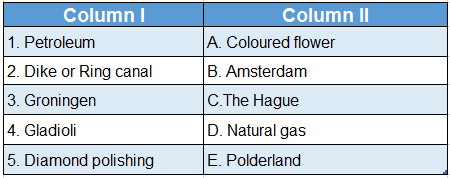
Answer: 1. c, 2. e, 3. D, 4. A, 5. B