
WBBSE Chapter 11 Continent Of Europe Topic C London Basin Long Question And Answers
Question 1. Briefly describe the physiography of the London Basin. Or, Describe the physical environment of the London Basin.
Answer:
Physiography of London Basin:
The physiography of the London Basin can be described as below-
1. Formation:
The London Basin is a low-lying basin. In ancient times, because of the tectonic movements, the region between the Chiltern Mountain in the north and the White Horse and North Downs Highlands in the south was subducted.
The river Thames and its tributaries like the Kennet and the Mole, have developed a rolling plain in this region by the deposition of silt, gravel and sand.
Read And Learn Also WBBSE Solutions For Class 7 Geography
2. Nature of soil:
A tough layer of chalk lies under the London Basin. On this lies a layer of Woolwich sand. The topmost layer is a spread of sand, gravel and fertile alluvium known as London clay.
3. Topography and river:
The London Basin is located in the lowlands between the Chiltern and the North Downs on the banks of the river Thames. This region is bounded on the north by the Chiltern Hills, on the south by the North Downs Hills and on the west by the White Horse Hills.
The major river Thames flows from west to east through this low land. The major tributaries of the Thames are Lee, Roading, Wey, Mode etc.
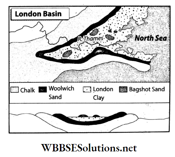
4. Slope:
The London Basin slopes gradually from the west to the east. The western part of the plain is narrow than the eastern part.
5. Climate:
The climate of the London Basin is cold and humid. Skies remain overcast and drizzle occurs throughout the year. Due to the influence of Westerlies, it rains here throughout the year.
The amount of annual rainfall is 60-75 cm. Due to the warm North Atlantic Drift, the winter temperature is not very low here.
6. Vegetation:
Vegetation is very low due to urbanization, industrialization and dense settlements. But some coniferous trees like oak, birch, beech, pine, ash, etc. grow in the higher altitudes of the hilly slopes.

Question 2. Describe the economic environment of the London Basin.
Answer:
The economic environment of London Basin:
The economic environment of the London basin can be described as below-
1. Agriculture:
- Most of the land is used for settlement and industry in the London Basin. But, due to the dense population, the demand of agricultural and livestock products is very high.
- Fruits and vegetables are produced on small farms.
- Mixed farming and truck farming are practised in this basin.
- Wheat, barley, and maize in the fertile lands around the river valley, hay, clover as fodder and oat, and potato in the highlands of Chiltern and North Down are grown.
2. Industry:
- This basin is well-developed in terms of industry. After the industrial revolution, there has been a huge development of industries here.
- Various industries such as automobile, ship repairing, engineering, chemical, bakery, printing, aircraft, dairy etc. have been developed in the cities of Oxford, Chatham, Gilford, London, Reading, Luton and many more.
3. Transport system:
- Rail and road networks are well-developed here. The area is also connected through the river Thames, its tributaries and interconnecting canals. London is a famous river port and international airport.
- In fact, one of the main reasons for the economic prosperity of this region is the well-connected transportation system.
Question 3. Describe the rivers of the London Basin.
Answer:
Rivers of the London Basin:
Rivers flowing through the London Basin are as follows-
The major rivers:
- The main river of the London Basin is the Thames.
- The Thames River originates from the Cotswold Hills lying in the west of the London Basin and then enters this region through the Roaring gap.
- It then flows eastward and discharges into the Northern Ocean. The River Thames is quite deep and forms a wide estuary.
The minor rivers:
- Several small tributaries join the Thames at various points on its course – the Lea and the Roading flow from the north, and from the west come the Wey and the Mole.
- The main tributary, Kennet, joins the Thames near the city of Reading.
- Chapter 11 Topic C London Basin Short Analytical Type Questions
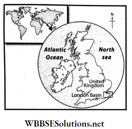
Question 4. Write what you know about the location and area of the London Basin.
Answer:
Location of the London Basin:
- The London Basin is situated on the banks of the river Thames.
- London, which is the main city as well as the commercial centre of the United Kingdom is situated in this basin region.
The boundary of the London Basin:
To the north of the London Basin is Chiltern Highlands, to the east is the North Sea, to the south is the North Downs Highlands and to the west is the city of Reading.
Area of the London Basin:
The total area of the London Basin is approximately 7,760 sq. km.
Question 5. Write what you know about the course of the river Thames.
Answer:
Course of the river Thames:
- The main river of the London Basin is the Thames. The river Thames originates from the Cotswold Hills lying in the west of this region and enters this region through the Goaring Gap.
- Then the river flows eastward and discharges into the North Sea. The river Thames is quite deep and forms a wide estuary.
- Several small tributaries join the Thames at various points on its course – the Lee and the Roading flow from the north, and from the west comes the Wey and the Mole. The main tributary, Kennett, joins the Thames near the city of Reading.
Question 6. Give an account of the climate of the London Basin.
Answer:
Climate of the London Basin:
- In the London Basin, the temperature does not rise very much in summer nor does the temperature fall very much in winter.
- Drizzles, overcast sky along with cold and humid weather for almost every day of the year is the defining characteristic of the climate and weather of the London Basin.
- In summer, the temperature ranges from 18°C to 20°C and in winter, it ranges from 3°C to 5°C. Snowfall sometimes occurs in winter. The average annual rainfall in this region is about 60 cm-78 cm. Most of the rainfall occurs in winter due to westerlies.
- This type of cold and wet climate is known as the Western Coastal Marine climate or the British Isles climate.
Question 7. What is the contribution of the River Thames to the development of the London Basin?
Answer:
Contribution of the River Thames to the development of the London Basin:
The river Thames plays an important role in the development of the London Basin. The ways in which the river has influenced the development are as follows-
- Water i.e. necessary for both agriculture and industry is available in plenty in this region because of the presence of the river Thames.
- The city of London which has grown and developed on the banks of the river Thames.
- London is the capital of the United Kingdom and an important trade centre not only for the country but also for the continent of Europe. This area has always received an easy supply of raw materials required for various industries via the Thames riverway.
- The river Thames is very deep and so, large ships can easily reach the different parts of this region.
- Fishes that are caught from the river Thames is sold in fish markets around the world.
- Thames River is known as the ‘industrial river’ of Europe. The London Basin is the most developed industrial region in the continent of Europe.
Question 8. Write about the agriculture of the London Basin.
Answer:
Agriculture of the London Basin:
- Vegetables, fruits and greens are grown in various small farms and stored in granaries in the London Basin and sent by trucks to the nearby cities. This is known as the practice of truck farming.
- Wheat and corn are grown in the podzol soil of the Thames and Kennet River valleys. Oats and potatoes are grown in the North Downs Highlands and the Chiltern Hills. Mixed farming is also practised in this region.
- Since the soil of the North Downs and Chiltern Highlands are relatively less fertile, hay, clover and other kinds of animal fodder are also cultivated here. Reading and Essex are famous for wheat production.
Question 9. Write about the transport system of the London Basin.
Answer:
The transport system of the London Basin are well developed. As in-
1. Railways and roadways:
An extensive and high-quality network of railways and roads crisscrosses the entire area. The subway rail system in London is also very well developed.
2. Waterways:
London is also a famous and busy port since ancient times because it is situated on the bank of the river Thames. As the river Thames has a high volume of water throughout the year, large ships can travel to and from London all year around.
3. Airways:
London is one of the main hubs for international travel along air routes. Heathrow Airport in London is one of the main hubs for international travel.
Conceptual Questions on Environmental Issues in the London Basin
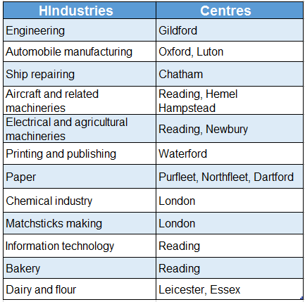
Question 10. What are the main industries and the main centres of these industries in the London Basin?
Answer:
The main industries and the main centres of these industries in the London Basin are tabulated below-
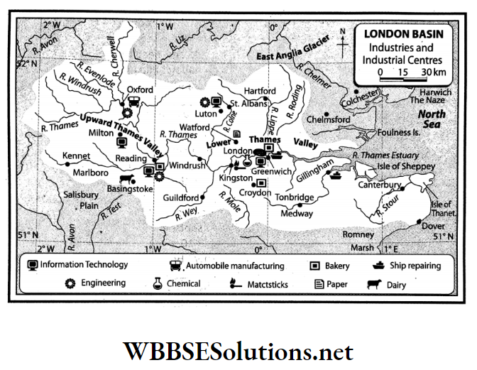
Question 11. What are the reasons for the industrial development of the London Basin region?
Answer:
The reasons for the industrial development of the London Basin region:
London is one of the main industrial centres of the British Isles. The reasons for the high development of industry and trade in this area are as follows-
- The proximity of the port of London i.e. Capital city of the united kingdom,
- Easy access to transport by waterways because of the river Thames and its tributaries,
- Well-developed transport and communication,
- The advanced banking industry,
- Proximity to north-eastern parts of Europe,
- Availability of skilled labour,
- Use of latest technology etc.
Apart from these, other factors which generally lead to the growth of centres of trade and industry are also present in this area.
WBBSE Chapter 11 Continent Of Europe Topic C London Basin Short Question And Answers
Question 1. What do you mean by the London Basin?
Answer:
London Basin:
- Thames River flows through the south-east of the United Kingdom. The river basin of the Thames is surrounded by Chiltern and North Downs Mountains. This area is known as the London Basin.
- London, the capital city of the United Kingdom is situated in this basin. Thus this region is named London Basin. The total area of this region is approximately 7,760 sq. km.
Question 2. Describe the boundary of the London Basin.
Answer:
The boundary of the London Basin:
London Basin is surrounded by Chiltern Mountain to the north, North Downs Mountain to the south, White Horse Mountain and Reading City to the west and North Sea to the east.
Real-Life Scenarios Involving Urban Development in the London Basin
Question 3. Why is the Thames known as the ‘Industrial River of Britain’?
Answer:
- On the bank of the River Thames in the London Basin, several industrial centres have developed. For example-London, Reading, Enfield, Harlow, Newbury, Luton and others.
- The Thames plays a major role in the supply of water as well as in facilitating export and import in the region. So, the Thames is known as the ‘Industrial River of Britain’.
Question 4. What is the natural vegetation of the London Basin?
Answer:
The natural vegetation of the London Basin:
- The London Basin is a highly industrialized area with several industries and factories and supports a large population. So, there is not much forestland or green coverage in this area.
- However, on the slopes of the highlands in this region, one can see some oak, pine, birch, ash, lock, pine and beech woods. Apart from this, some meadows and grasslands can also be seen on the slopes of the highlands.
Question 5. Write a short note on the city of London.
Answer:
City of London:
- The city of London, on the banks of the river Thames, is the capital of the United Kingdom as well as the main city and main port. London is the world’s largest re-export port.
- In the city of London, engineering, wool and chemical industries have flourished. The main tourist spots in London are Buckingham Palace, 10 Downing Street, Hyde Park, Parliament House, British Museum and so on.
Question 6. Why is the city of Greenwich famous?
Answer:
- The city of Greenwich is situated a little to the east of the city of London.
- The Prime Meridian or 0° longitude is imagined to pass over this city from north to south. The Royal Observatory in Greenwich is also world-famous.
Question 7. Write a short note on the city of Reading.
Answer:
City of Reading:
- Reading is a famous city situated at the confluence of the rivers Thames and Kennett in southern England.
- Industries like engineering, bakery, information technology and weaving have developed and flourished here.
Question 8. Why is London known as the Entrepot port? Why is London called a re-export port?
Answer:
- Entrepot port is the port where products imported from a foreign country are then exported from the same port to some other country.
- The port of London imports tea, coffee, spices, tobacco and other products from Asia, Africa and South America. Here, these products are processed and exported to other European countries.
- That is why London is known as the Entrepot port.
WBBSE Chapter 11 Continent Of Europe Topic C London Basin Very Short Question And Answers
Question 1. What is the shape of the London Basin?
Answer: Elongated triangle like a clay saucer.
Question 2. In which direction does the London Basin generally slope?
Answer: From west to east.
Question 3. Which is the highest peak in the British Isles?
Answer: Ben Nevis.
Question 4. Which is the main river of the London Basin?
Answer: The Thames.
Question 5. Where is the mouth of the Thames River?
Answer: North Sea.
Question 6. What is the capital of the British Isles?
Answer: London.
Question 7. Name one of the most significant industrial regions in the British Isles.
Answer: London.
Question 8. Name a re-export port in Europe.
Answer: London.
Question 9. Name an airport in London which is one of the busiest in Europe.
Answer: Heathrow.
WBBSE Chapter 11 Continent Of Europe Topic C London Basin Fill In The Blanks
Question 1. ________ river is called the heart of the London Basin.
Answer: Thomas
Question 2. The river Thames has its source in the ________ Hill.
Answer: Cotswold
Question 3. Two tributaries of the river Thames are ________ and ________.
Answer: Lee, Roading
Question 4. One farming practice that is commonly seen in London is called ________.
Answer: Truck-farming
Question 5. ________ is the main airport of London Basin.
Answer: Heathrow
Question 6. The city of Newbury is on the banks of the river ________.
Answer: Thames
Question 7. Europe’s busiest airport is ________.
Answer: Heathrow
WBBSE Chapter 11 Continent Of Europe Topic C London Basin True Or False
Question 1. The main agricultural product of Europe is barley.
Answer: False
Question 2. The Chiltern Hills and the North Downs are situated in the London Basin.
Answer: True
Question 3. The London Basin is primarily composed of granite rock.
Answer: False
Question 4. The Greenwich Observatory is in the city of Greenwich.
Answer: True
Question 5. The climate of the London Basin exhibits all the features of the climate of the British Isles.
Answer: True
Question 6. Ben Nevis in the Grampian range is the highest peak in the British Isles.
Answer: True
Question 7. One of the main tributaries of the river Thames is Lee.
Answer: True
Question 8. The busiest airport in the British Isles is Heathrow in London.
Answer: True
Question 9. The local time at the city of Reading in the London Basin is considered the universal time for the world.
Answer: False
WBBSE Chapter 11 Continent Of Europe Topic C London Basin Match The Columns
Question 1.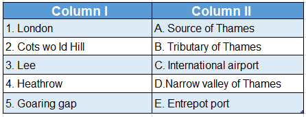
Answer: 1. E, 2. A, 3. B, 4. C, 5. D