
WBBSE Chapter 10 Continent Of Africa Topic C Worlds Largest Hot Desert Sahara Long Question And Answers
Question 1. Describe the topographical features of the Sahara Desert.
Answer:
Topographical features of the Sahara Desert:
Physically, the Sahara Desert is part of an arid plateau region. The highest point in the desert is Mount Koussi (3415 m) in the Tibesti Mountains in Chad and the lowest is in the Qattara Depression (133 m below sea level) of Egypt.
The principal topographical features of the Sahara include the following-
1. Chotts or Shotts:
- A chott or shott is a dry salt lake in the Saharan area of Tunisia, Algeria and Morocco that stays dry in the summer, but receives some water in the winter.
- These lakes have changing shores and are dry for most of the year.
2. Large oasis depressions:
- Most oases are watered by a natural spring and other underground water sources called aquifers.
- Sometimes, a natural spring brings the underground water to the surface and at other times, manmade wells tap the aquifers. Kufra and Tuat are examples of important Saharan oases.
Read And Learn Also WBBSE Solutions For Class 7 Geography
3. Regs:
Regions of the desert where sand and rock fragments are found together.
4. Hamadas:
Hamadas of the Sahara Desert are the stony plains covered with gravel or boulders and no sand.
5. Sand dunes:
A sand dune is a mount, hill or ridge of sand deposited by blowing winds.
6. Aergs:
- An area is a large accumulation of sand in the form of a hill, deposited by the wind, mostly at the bottom of a huge basin that was earlier piled up by alluvium. It is also known as the Sand Sea.
- Aergs are shifting sand dunes that are loose and generally very difficult to cross.
- In the area between Algeria and Libya lies the Great Eastern and the Great Western Aergs.
These areas are so difficult to cross that they are avoided in the modern Trans-Saharan route.
Conceptual Questions on Desertification and Environmental Issues

Question 2. Discuss the livelihood facilities of the people of the Sahara.
Answer:
Livelihood facilities of the people of Sahara:
Two types of settlers are found in the Saharan region. They are-
1. The permanent settlers:
- In several oasis regions, permanent villages can be found.
- To safeguard from the enemies the houses are closely built and are bounded by high boundaries. In several parts of Egypt in Katara and Katala oases, such permanent villages are found.
- In these regions, the settlers practice agriculture.
- Crops like wheat, barley, maize, walnut, and dates are grown with the help of irrigation.
2. The nomadic wanderers:
- The nomadic wanderers move from place to place in search of food.
- The main livelihood of this kind of people is animal rearing. Major types of animals that are reared in these regions are camel, goat, sheep, horse and such others.
- At present many former nomadic wanderers are observed to be settling down permanently.
- Among the nomadic wanderers Tuareg, Bedouin, Berber and such others need special mention.
Question 3. What changes have taken place in the Sahara Desert over time?
Answer:
Changes in the Sahara Desert over time:
The Sahara Desert has undergone many changes over time-
- Planting of xerophytes: Xerophyte plants are being planted in many parts of the desert where there is groundwater. Green grass is also being planted in many places.
- Road construction: The roads that were used by camels have now been paved. Even highways are being built. This has made the life of the people of the desert more prosperous.
- Rainwater harvesting: Rainfall is very low in the Sahara, yet arrangements are being made to retain rainwater when it rains. This has improved agriculture.
- Power generation: Solar power generation has been increased. This has changed the lives of the people of the Sahara.
- Change of occupation: The people of the local Tuareg tribe are working as travel guides to help foreign tourists.
- Permanent settlement: Many nomadic herders are working in petroleum and natural gas extraction centres. As a result, they are now living in the cities permanently.
Question 4. What are the effects of global warming on the Sahara Desert?
Answer:
Effects of global warming on the Sahara, Desert:
The temperature of the Earth’s surface is rising. The temperature rise in the Sahara Desert and the expansion of the desert should be a consequence. But, the latest studies show that the situation in Sahara is otherwise, as in-
- The rise of the average temperature of the Earth’s surface has led to a sea level rise. This has led to an increase in water vapour content in the atmosphere and thus the amount of rainfall has also increased.
- The increase in the amount of rainfall has led to an increase in greenery in various places in the southern part of Egypt.
- Fossils of aquatic plants and animals have been found in the rocks of the Sahara which proves that once upon a time the region had enough rain.
- The increase in the amount of rainfall in the Sahara has led to an increase in agricultural and animal-rearing activities in and around this region.
- Scientists opine that global warming has led to increasing the diversity of animals of this region.
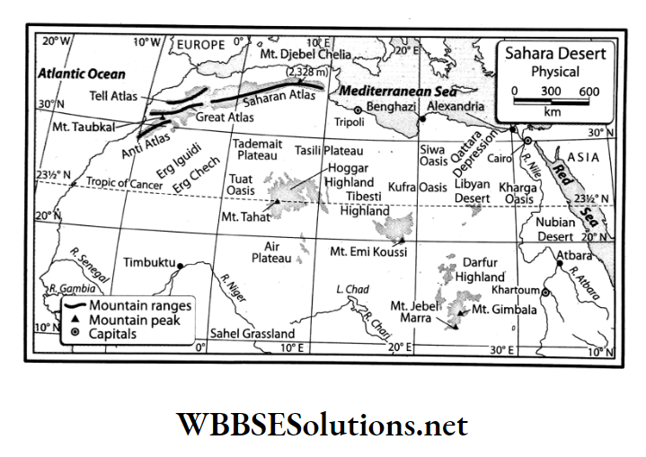
Question 5. Name the places surrounding the Sahara Desert.
Answers:
1. Atlas Mountain and the Mediterranean Sea
2. Atlantic Ocean
3. Sahel Grassland
4. Red Sea
Examples of Real-Life Applications of Knowledge about the Sahara
Question 6. Name the marked places on the outline map of Africa.
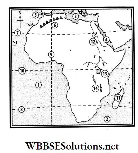
Answers:
1. Atlantic Ocean
2. Indian Ocean
3. Mediterranean Sea
4. Red Sea
5. Strait of Gibraltar
6. Atlas Mountain
7. Tropic of Cancer
8. Tropic of Capricorn
9. Prime Meridian
10. Equator
11. Madagascar
12. River Nile
13. Lake Victoria
14. Lake Malawi
Question 7.

Down:
1. A neighbouring country of Egypt.
2. Meeting place of the Blue Nile and the White Nile.
3. Mountain in northwest Africa.
4. Dam on the River Nile.
Across:
2. A desert in South Africa.
5. Capital of Egypt.
6. Longest river in the world.
Answers:
Down: 1. SUDAN, 2. KHARTOUM, 3. ATLAS, 4. ASWAN
Across: 2. KALAHARI, 5. CAIRO, 6. NILE
Question 8.

Down:
1. An African country.
2. Capital of Zambia.
3. Largest river of South Africa.
Across:
2. A waterfall in Africa.
4. Diamond mine of Africa.
Answers:
Down: 1. ZIMBABWE, 2. LUSAKA, 3. ORANGE.
Across: 2. LIVINGSTONE, 5. KIMBERLEY
Question 9. Name the factors that have hindered the development of Africa.
Answer:
Though Africa is the second largest continent on Earth, yet it is not as developed as most of the other continents. The hindering factors are as follows-
Geographical hindrance:
- Rugged landform,
- Unfavorable hot desert type of climate and
- Infertile land
Socio-economic hindrance:
- Under-developed agricultural activities,
- Inadequate raw materials for developing industries,
- Lack of transportation and Untrained human resources.
Question 10. Write down topics from physiography, rivers, climate, and natural vegetation of Africa on small pieces of paper. For example, write ‘Sahara’ on a chit. Get into a group and pick up a chit each. Open it and see your topic. Now you have to talk for about two or three minutes on your topic.
Answer:
Topics such as physiography, rivers, climate, and natural vegetation of Africa have already been written on small pieces of paper. Now, the chit picked has ‘Sahara’ written on it.
Information on Sahara gathered from several books is as follows-
- Sahara is the largest hot desert on Earth. It is bounded by the Atlas Mountains and the Mediterranean Sea to the north, the Sahel Grasslands to the south, the Red Sea to the east, and the Atlantic Ocean to the west.
- It encompasses 11 countries of the continent. It is a plateau region composed of ancient rocks with an elevation of about 2500 m at some places.
- The vast expanse of the Sahara is an extensive sandy and rocky terrain interspersed with thorny bushes in some places. The climate here is hot and dry with barely any water vapour in the atmosphere. In summer the temperature shoots up to 50°C or even more.
- Al Azizia of Libya (located to the north of the Sahara) experienced a temperature of about 57.7°C in the year 1922. The vegetation found in this region is mainly cacti and date palms.
- Crops like maize and millets are grown around the oases where there is little water availability or some favorable irrigation facility. The cultivators roam around with their animal herds, especially camels in search of food and water.
- Camel is the main mode of transport. However, in recent times the lives and livelihoods of the people of the Sahara have seen a remarkable change. Likewise, there would be class discussions on the other topics written on various chits.
Question 11. Make a report on the advantages and disadvantages of living in the Sahara Desert. Find similarities and differences with your way of living. This report can be done on the basis of group discussion.
Answer:
Advantages of living in the Sahara Desert:
- Dry farming in the oases of the Sahara Desert produces maize, sorghum, millets, barley, and some vegetables. Moreover, in this desert, there are plenty of date palm trees and lots of dates are produced commercially.
- In the desert, due to lack of rainfall, vegetation is almost nil, some grasses and thorny bushes grow here. The Tuareg community, therefore, raises animals. When the animal fodder runs out of stock, they go elsewhere according to their nature.
- The recent discovery of petroleum and natural gas in Libya and Algeria, and scattered mineral salts, iron ores, and coal have been a source of alternative jobs for the people of this region.
Disadvantages of living in the Sahara Desert:
- Dry, soilless rocky terrain is unfit for agriculture.
- Occasional dust storms make people’s lives miserable.
- The transportation network is very poor due to harsh climatic conditions and thus the way of life is very difficult.
- Permanent settlements can not be built due to environmental adversity other than the ones around oases.
- There has been no industrial development. However, due to the recent discovery of oilfields, some oil refineries have sprung up.
Similarities and differences with our way of life:
The similarities of living in the Sahara with our way of living are-
- People live permanently in and around the oases and do a small amount of agriculture.
- The workers in the mines also live the same life as workers in our region.
The differences of living in the Sahara with our way of living are-
- The community living in the desert lives a nomadic life.
- Community ownership still prevails instead of private ownership.
- Reliance on camels rather than vehicles is extremely high.
- Lack of water, and living in a harsh environment do not match with our way of living.
Question 12. Fill up correctly:
Answer:
Question 13. Try to know how climate change is likely to affect other parts of the world, apart from the Sahara Desert.
Answer:
The phenomenon of the rise of global average temperature is called global warming. As a result of this climatic change, the temperature of the Earth in the last century has risen by 4° Celsius. The fifth longest river of Africa. 2 29 reservoirs have been constructed on this river.
The average global temperature could rise by 1.5°C -2°C by the middle of this century. The effects of global warming can be devastating. However, in some places, its positive effects are also being noticed.
Climate change can bring out some effects on other parts of the world, apart from the Sahara Desert, such as-
- Due to the rapid melting of polar ice, the sea level has risen by 3mm per year in the last two decades of the last century. In the last decade of this century, a sea level rise of 5mm per year has been noticed.
- Many islands in the Sundarbans, including Ghoramara, Lohachara, and New Moore have submerged in the sea and many more islands could get submerged.
- As the sea level rises, the coastline may gradually shift more towards land area.
- The ocean currents are changing considerably and the global climate is changing as a result of the change in currents.
- Rainfall is increasing in mid-latitude countries.
- Rainfall is decreasing in the tropics which could lead to changes in agriculture.
- Increasing rainfall in the Prairie region could increase the height of the grasses
- The amount of greenery in the Sahara Desert may increase.
Question 14. Fill up the knowledge hive with information about the Tuareg tribe.
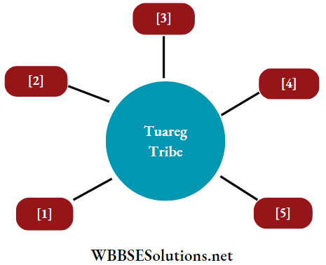
Answers:
1. The Tuareg tribe lives in Algeria and Libya on) 129 of the Sahara Desert.
2. Traditionally wanderers, today the Tuareg people use trucks instead of camels to carry goods.
3. Work as tourist guide to foreign tourists.
4. They have now started working in the local oil companies.
5. They wear loose white robes, turbans and gas mines.
WBBSE Chapter 10 Continent Of Africa Topic C Worlds Largest Hot Desert Sahara Short Question And Answers
Question 1. Write an account of the location and extent of the Sahara Desert.
Answer:
The location and extent of the Sahara Desert:
- The Sahara Desert is located in the northern part of Africa. It extends from the coast of the Atlantic Ocean in the west to the coast of the Red Sea in the east and from the Atlas Mountains in the north to the Niger Basin and the Sahel Asine Grassland in the south.
- The Saharan desert region extends over the countries of Algeria, Chad, Egypt, Eritrea, Libya, Mali, Mauritania, Morocco, Niger, Sudan, Tunisia and western Sahara.
- The approximate area of the Sahara Desert is 9.2 million sq km. It is almost the same size as Europe and 2½ times of India. It is the largest hot desert in the world.
Question 2. Write about the physical characteristics of the Sahara Desert.
Answer:
The physical characteristics of the Sahara Desert are-
1. Huge physiographic extent:
- Sahara is a huge desert consisting of extensive regions of Sandy and rocky terrain.
- It is a plateau region consisting of vast stretches of sand and rocky fragments.
2. Narrow river channels:
- Most of the rivers of this desert region originate from the Atlas Mountains or the Ahaggar and Tibesti Plateau Region.
- Some rivers even disappear in the sand and the river channels of this region are extensively narrow.
3. Extreme climate:
The climate existing in this region is of an extreme type. The seasonal and diurnal range of temperatures are extreme and it hardly rains.
4. Desert vegetation:
- Cactus types of trees are the most common in this region.
- In certain places, oases have also developed due to wind erosion.
Question 3. Write a short note on Aerg, Reg and Hamada.
Answer:
Aerg, Reg and Hamada:
- Aerg is a large accumulation of sand deposited by the wind in the form of a small hill in the Sahara Desert.
- The regions of the desert where sand and rock fragments are found together are called Reg. Hamada is the rocky part of the desert with no sand.
Question 4. Write a brief note on Wadi.
Answer:
Wadi:
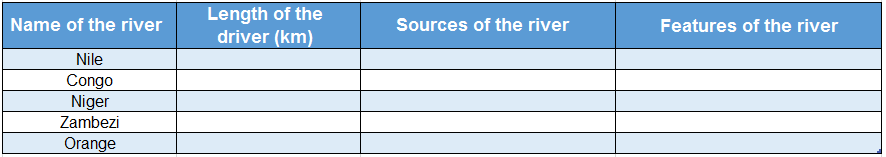
- The Sahara Desert being a dry region does not see many rivers. Only the Nile flows through the east and Niger flows through the south-western part of the Sahara.
- During the rains, sometimes small rivers emerge, that dry up very soon in the arid climate.
- This dry non-perennial river in the east of the Sahara Desert or a valley or streambed in northern Africa that remains dry except in the rainy season is known as Wadi.
- Wadi Draa is an ideal example of the dry river of the Sahara.
Question 5. Discuss the important climatic characteristics of the Sahara Desert region.
Answer:
Important climatic characteristics of the Sahara Desert region:
Sahara is the hottest and driest desert in the world. The important climatic characteristics of this region are as follows-
- Tremendously hot days and extremely cold nights.
- Summer temperatures that sometimes shoot up to 58°C during the day and come down to 4°C during the night.
- Rainfall of about 15 cm in certain places and no rainfall at all in some other places.
- The overall climate of the Sahara is hot and dry and stays around the extreme type.
- Sometimes hot sandstorms are noticed in this regions-these are known as Simoom in the local language. Khamsin in Egypt and Harmattan near the Gulf of Guinea is a warm-dry wind that blows from Sahara in summer.
Understanding the Sahara Desert
Question 6. Why is a desert as big as Sahara, formed in the tropical region of Africa?
Answer:
The reason why the Sahara Desert has formed in the tropical region of Africa are as follows-
1. North-east trade winds:
- The northeast trade winds blow in the northern part of the Sahara.
- This is a dry wind blowing from Eurasia.
- Since the water vapour content in the wind is nil, thus it does not cause any rainfall.
2. South-east trade winds:
- The southeast trade winds blow over waterbodies before entering Africa and thus cause rainfall in the south-eastern coast of Africa after being struck by the mountains along that coast.
- Thereafter, the winds are devoid of any rainfall while blowing northwards in the continent towards Sahara.
- As a combined influence of these two dry winds, the Sahara has formed as a desert region in spite of being in the tropics.
Question 7. Give a brief account of agriculture in the Sahara Desert Region.
Answer:
Agriculture in the Sahara Desert Region:
- Scarce availability of water and infertile soil with an abundance of sand poses an eternal problem for cultivation in the Sahara Desert region.
- So, agricultural activities are quite limited in this region.
- Agricultural activity can only be noticed in the oasis regions of the Sahara Desert.
- In these regions, some minimal agricultural activities are noticed that too with the help of well and canal irrigation. Crops like maize, dates and millet are grown here.
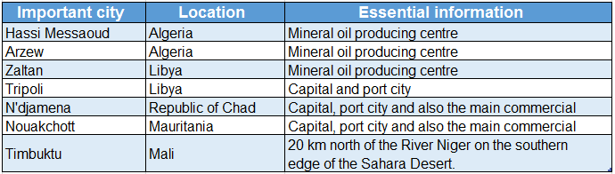
Question 8. Name some important cities of the Sahara Desert.
Answer:
Some important cities of the Sahara Desert are as follows-
Question 9. Give a brief account of transportation facilities in the Sahara Desert Region.
Answer:
Transportation facilities in the Sahara Desert Region:
- The transportation facilities of the Sahara Desert Region is underdeveloped and still very primitive. The major form of transportation of the Sahara Desert Region is on the backs of camels.
- This is why the camel is also known as the ‘Ship of the desert’.
- Camel is the only mode to travel between the oases of the Sahara Desert. In the recent past, due to the development of oil refineries, motor vehicles have started plying in some places, like in the Niger Basin in Algeria and the Chad Basin.
- Some of the crucial airports of the Sahara Desert Region are Dakhla, Hassan-I, Smara (Semara), Kano and others.
Question 10. What would have happened if the Sahara Desert was located in the south of Africa?
Answer:
The Sahara Desert is located in the northern part of tropical Africa. If the desert was located south of Africa, the following would have happened.
- Climate change: A temperate climate instead of a tropical climate would have prevailed. The coastal areas along the Indian Ocean in southern Africa would have been very cold.
- Change of vegetation: Temperate grassland instead of desert plants could have been seen.
- Season change: The opposite seasons would have prevailed instead of the present ones.
- Changes in the natural and cultural environment: Almost opposite characteristics of the present natural and cultural environment of the Sahara Desert would have prevailed.
Question 11. Why are settlements almost absent in the Sahara Desert?
Answer:
Settlements are not found in the Sahara Desert because-
1. Sandy terrain:
Sandy terrain of the Desert makes the land unfit for the growth of the settlement.
2. Extreme climate:
- The climate of this region is extremely dry and the diurnal range of temperature is also extreme.
- The temperature shoots up to 58°C during the day and falls down to 4°C at night.
- There is hardly any evidence of rainfall. Thus, the climate is highly unsuitable for the growth of settlement.
3. Infertile soil:
The soil of this region is infertile and its salt content is very high. Thus, it cannot support agriculture on a proper basis and as a result, settlement does not flourish in and around this region.
Question 12. What are the advantages and disadvantages of global warming in the Sahara Desert Region?
Answer:
The advantages and the disadvantages of global warming in the Sahara Desert are-
1. Advantages of global warming: The consequence of rainfall as a result of global warming has led to an increase in agricultural activities, animal rearing and an increase in the species diversity of the region.
2. Disadvantages of global warming: The evidence of fossils found on the rocks of this region explains the presence of greenery once upon a time. However, the region has gradually turned dry and arid due to climate change.
Question 13. Name the rivers of the Sahara.
Answer:
Rivers of the Sahara:
- Nile River flows through the eastern Sahara and rivers like Niger, Chari, and Logon flow through the southwestern Sahara.
- The Sahara region does not see an abundance of rivers because it is dry and rainless. Even the rivers that flow, mostly remain dry, except the Nile. Wadi Draa is a dry river of the Sahara.
Question 14. Why is Sahara sparsely populated?
Answer:
- The Sahara Desert is sparsely populated because temperatures constantly touch 55°C during the day and drop very low at night, so it is difficult for people to live there. The average rainfall is very low.
- There is no fertile soil cover and so, agriculture cannot be done. Due to limited water supply, it is difficult to sustain livelihoods and lives.
- Its isolated location, poor communication systems, restricted accommodation and few job opportunities are additional factors for a sparse population.
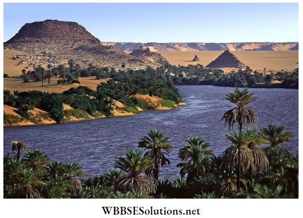
Question 15. How does an oasis form?
Answer:
- Most oases are watered by natural springs and other underground water sources. Underground water sources called aquifers supply water to most of the oases.
- Sometimes, a natural spring brings the underground water to the surface and at other times, manmade wells tap the aquifer. Kufra and Siua are examples of important Sahara oases.
Real-Life Scenarios Involving Oases in the Sahara
Question 16. What is Khamsin?
Answer:
Khamsin:
A kind of hot local wind in the Sahara Desert is known as Khamsin. This wind blows with extreme heat and dryness in summer. The heat of this wind kills people and cattle.
Question 17. Describe the natural vegetation of the Sahara Desert.
Answer:
Natural vegetation of the Sahara Desert:
- Sahara Desert is thinly covered by an ambit of natural vegetation that ranges from grasses to hardy shrubs to trees with long root systems, which are saline tolerant.
- The natural vegetation of the Sahara is adapted to the heat and highly unreliable precipitation.
- Many of the Saharan areas see the growth of thorny bushes and cacti, which are naturally adapted to the retention of moisture within their body.
- In the oasis regions palm family of trees like dates can be seen.
Question 18. Write about the mineral deposits of the Sahara Region.
Answer:
The mineral deposits of the Sahara Region:
- The existence of extreme weather conditions makes it very difficult for mineral extraction in the Sahara Region.
- Yet, reserves of petroleum and natural gas have been found in Libya and Algeria. Salt, coal and iron ore are also found.
- Developed transport networks and airports have been built in recent times for the development of mining and easy transportation of the extracted minerals.
- The nomadic animal herders have now started working in the local oil and gas mines.
Question 19. Write about the industrial growth in the Sahara Desert Region.
Answer:
The industrial growth in the Sahara Desert Region:
- Harsh environment, inadequate raw material for heavy industries, lack of infrastructure, insufficiency of power supply and inadequate investments are some of the reasons for which the Sahara Desert Region has not witnessed much industrialisation.
- The only kind of industry that is found in the region are oil refineries, wool and cotton weaving mills, sugar mills and some small-scale handicrafts.
Question 20. Was Sahara always under the influence of the hot desert-type climate?
Answer:
- Sahara was not always under the influence of the hot desert-type climate. Very recently the fossils of aquatic plants and animals found on the rocks in the Sahara clearly prove this fact.
- So, it can be supposed that once Sahara was under the influence of a wet rainy climate
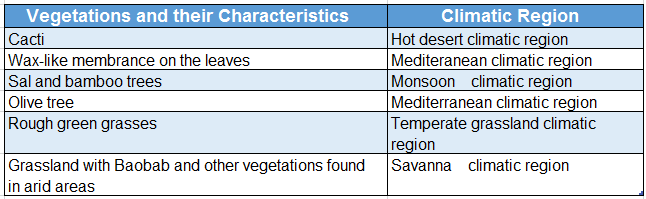
Question 21. Which tree would you find in which climatic region?
Answer:
Question 22. Which river is known as the Oil River and why?
Answer:
- Niger is known as the Oil River. The most important reason for this is that this region was once the major producer of palm oil.
- Moreover, the Niger River Basin in Nigeria is known as the biggest producer of petroleum in Africa.
Question 23. Give a brief description of Lake Turkana (formerly known as Lake Rudolf).
Answer:
- Lake Turkana (6405 sq. km), formerly known as Rudolf Lake, is the fourth-largest lake among the East African lakes. It is the world’s largest permanent desert lake.
- The major portion of the lake lies in Kenya, while the northern part stretches into Ethiopia. The lake is a rich reservoir of fish.
Question 24. Briefly describe Drakensberg’s Mountain.
Answer:
Drakensberg’s Mountain:
- The African meaning of the word Drakensberg Mountain, the main mountain of South Africa, is ‘Dragon Mountain’.
- Running parallel to the coast of South Africa, Drakensberg Mountain rises to more than 3475 m and stretches from northeast to south- west for about 1125 km. Thabana Ntlenyana is the highest point of Drakensberg Mountain.
- Rock and cave art can be noticed in this range. Apart from this, several game reserves and parks are also present here.
- The Ukhahlamba Drakensberg Park was designated as a UNESCO World Heritage Site in the year 2000.
Important Definitions Related to the Sahara Desert
Question 25. Name the ocean currents that flow parallel to the coastline of Africa.
Answer:
The ocean currents that flow parallel to the coastline of Africa originate from the Atlantic Ocean in the western side and from the Indian Ocean in the eastern side.
The ocean currents from the Atlantic Ocean are-
- The Canary Current flows along the African coast from north to south between 30°N and 10°N
- The Guinea Current flows to the east along the Guinea coast of West Africa.
- Benguela Current flows northward along the west coast of southern Africa nearly to the Equator.
The ocean currents from the Indian Ocean are-
- Somalian Current flows along the coast of Somalia and Oman in the Western Indian Ocean.
- The East Madagascar Current flows near Madagascar.
- The Mozambique Current flows south along the African east coast in the Mozambique Channel, between Mozambique and the island of Madagascar.
Question 26. Why have the deserts of Africa formed near the tropical and the sub-tropical regions?
Answer:
- Most of the northern part of Africa is covered by the Sahara, the world’s largest desert, and in the southern hemisphere lies the Kalahari Desert.
- Both of these are located in the tropical and the sub-tropical regions and as a result lie under the influence of the trade winds.
- These trade winds originate from the sub-tropical high-pressure zone and move towards the equatorial low-pressure zone.
- As they move from the relatively cooler zone to the hotter zone, the moisture-carrying capacity of the trade winds becomes very high.
- So, we observe very little cloud formation and subsequent rainfall near the sub-tropical regions. This leads to the formation of these enormous deserts.
Question 27. Briefly describe the temporary irrigation system of the Nile River Basin.
Answer:
- In the lower Nile Basin, natural levees and floodplains have formed on either side of the river banks. These floodplains are very narrow, extending only about 20 km.
- During the summer, as the Blue Nile encounters heavy monsoon rainfall in the Ethiopian Highlands, the lower course of the River Nile floods. The floodwater is allowed to flow to the lower floodplains by opening the sluice gate.
- This helps the soil to rejuvenate with newly accumulated silt and thereafter a large amount of crops can be grown. In this way, starting from Aswan till the delta region of the Nile River, irrigation becomes possible.
- But this operation is only possible during the time of flood, and so, it is described as the temporary irrigation system of the Nile River Basin.
Question 28. Give a brief account of animal rearing in Africa.
Answer:
Animal rearing in Africa:
There are quite a number of places in Africa that are known for their animal rearing. They are as follows-
- In South Africa, there is a large stretch of temperate grassland or Veld in its plateau region. This grassland is mostly used for sheep rearing.
- To the north, east, and south of the equatorial rainforest region, lies the large expansion of tropical grassland or Savanna. Livestock like cattle and pigs is reared here in the countries of Sudan, Angola, Nigeria, Uganda, Kenya, Zimbabwe, and such others.
WBBSE Chapter 10 Continent Of Africa Topic C Worlds Largest Hot Desert Sahara Very Short Question And Answers
Question 1. Name the hottest desert of the world.
Answer: Sahara Desert.
Question 2 Name the highest peak in the Sahara Desert.
Answer: Emi Koussi.
Question 3. What are the shifting sand dunes of Africa known as?
Answer: Aerg.
Question 4. What are the stony plains covered with gravels or boulders of the Sahara Desert known as?
Answer: Hamada.
Question 5. What are the dry non-perennial river channels in the east of the Sahara Desert known as?
Answer: Wadis.
Question 6. What is Khamsin known as near the Gulf of Guinea?
Answer: Harmattan.
Question 7. What are the sandstorms of the Sahara during the summer is known as?
Answer: Simoom.
Question 8. What is the isolated vegetation surrounding a waterbody in a desert known as?
Answer: Oasis.
Question 9. Name a tribal group of Algeria.
Answer: Tuareg.
Question 10. I am a continent that stretches from almost 38°N to 35°S. Who am I?
Answer: Africa
Question 11. I have developed Egypt as ari agro-based country. Who am I?
Answer: River Nile
Question 12. I was once known as the ‘Dark Continent’. Who am I?
Answer: Africa
Question 13. I am the highest peak of Africa. Who am I?
Answer: Mt. Kilimanjaro
Question 14. I am a desert in north-central Africa. Who am I?
Answer: Sahara desert
Question 15. I am the longest tributary of the River Nile. Who am I?
Answer: White Nile
Question 16. The Livingstone Waterfall has formed on my course. Who am I?
Answer: River Congo
Question 17. originates from the western slope of Drakensberg Mountain. Who am I?
Answer: River Orange
Question 18. I am the second largest freshwater lake of the world. Who am I?
Answer: Lake Victoria
Question 19. Bamako, the capital city of Mali is located on my bank. Who am I?
Answer: River Nigar
Question 20. The continent of Africa is located to my south. Who am I?
Answer: Europe
Question 21. I am a waterbody separating Asia from Africa. Who am I?
Answer: Red sea
Question 22. I am an ocean current that has influenced in the formation of the Sahara Desert. Who am I?
Answer: Candy’s current
Question 23. I am generally used as a cattle grazing area. Who am I?
Answer: Temperate grassland(veld)
Question 24. I am a popular oasis located in the Sahara Desert. Who am I?
Answer: Kufra/ Tuat
Question 25. Victoria Waterfalls has formed on my course. Who am I?
Answer: River Zambezi
Question 26. In South Sudan, the two popular dams- Sennar and Atbara have been constructed on my course. Who am I?
Answer: Blue Nile
Question 27. In my lower course, the famous city of Alexandria has developed. Who am I?
Answer: River Nile
Question 28. I am the most prominent source of transportation for the people of. Sahara. Who am I?
Answer: Camel
Question 29. I am the largest country in Africa. Who am I?
Answer: Algeria
Question 30. I rise from Guinea Highlands in the eastern side of the Fouta Djallon. Who am I?
Answer: River Niger
Question 31. Who are the nomads?
Answer:
Nomads:
Nomadic people are those who move from place to place with their flock of animals. They have no permanent settlements. They roam the desert in search of water and food. Animal milk and meat are their main food.
Question 32. What is Harmattan?
Answer:
Harmattan:
The hot and dry wind or Khamsin from the Sahara Desert in summer blowing along the Guinea Coast is known as Harmattan
WBBSE Chapter 10 Continent Of Africa Topic C Worlds Largest Hot Desert Sahara Find The Odd One Out
Question 1. Mount Toubkal: Mount Everest: Mount Kilimanjaro: Mount Cameroon
Answer: Mount Everest (not located in Africa)
Question 2. Sahara: Namib: Kalahari: Thar
Answer: Thar (not an African Desert)
Question 3. Nile: Brahmaputra: Niger: Zambezi
Answer: Brahmaputra (not a river flowing through Africa)
Question 4. Khartoum: Brazzaville: Aswan: Cairo
Answer: Brazzaville (not a city on the Nile)
Question 5. Aswan: Kisangani: Kinshasa: Brazzaville
Answer: Aswan (not a city on the banks of Congo)
Question 6. Niger: Congo: Orange: Zambezi
Answer: Zambezi (not a west-flowing African river)
Question 7. Olive: Willow: Walnut: Fig
Answer: Willow (not a tree of the Mediterranean vegetation)
WBBSE Chapter 10 Continent Of Africa Topic C Worlds Largest Hot Desert Sahara Fill In The Blanks
Question 1. Various designed rocks are carved out in Sahara due to the action of ________.
Answer: Wind
Question 2. The Tibesti Plateau is of ________ origin.
Answer: Volcanic
Question 3. The small sand hills deposited by the wind or the shifting sand dunes of the Sahara Desert are known as ________.
Answer: Aerg
Question 4. The stony plains covered with gravel or boulders of the Sahara Desert are known as ________.
Answer: Hamada
Question 5. The dry non-perennial river channels in the east of the Sahara Desert are known as ________.
Answer: Wadi
Question 6. Kufra, Siua, Timimon are important ________ of Africa.
Answer: Oases
Question 7. A chief agricultural crop in Sahara is ________.
Answer: Maize
Question 8. The most important mineral resource of the Sahara Desert is ________.
Answer: Mineral oil
Question 9. In Sahara, the main ride for the inhabitants is ________.
Answer: Camel
WBBSE Chapter 10 Continent Of Africa Topic C Worlds Largest Hot Desert Sahara True Or False
Question 1. The dry river valley in the Sahara Desert is known as Hamada.
Answer: False
Question 2. The highest peak of the Sahara Desert is Emi Koussi.
Answer: True
Question 3. Coal is an important mineral resource of the Sahara Desert region.
Answer: False
Question 4. The warm wind that originates from the Sahara Desert is known as Khamsin in Egypt.
Answer: True
Question 5. Half moon-shaped sand dunes are known as pediments.
Answer: False
Question 6. The size of the Sahara Desert is more than double that of India.
Answer: True
Question 7. El Azizia in Algeria is the hottest place on the earth.
Answer: False
Question 8. A group of camels moving in a line, mostly for the purpose of trade is known as a ‘Caravan’.
Answer: True
WBBSE Chapter 10 Continent Of Africa Topic C Worlds Largest Hot Desert Sahara Scrambled Words
1. EGARTU
2. EXALDRANIA
3. YIGANTANKA
4. KIJALIROMAN
5. HIOPETIA
6. GASANKINI
7. GERIANI
8. ACIAAC
9. HALAKARI
10. IATORVIC
11. MATHARTAN Answers
12. RRDIEANTEMEAN
Answers:
1. TUAREG
2. ALEXANDRIA
3. TANGANYIKA
4. KILIMANJARO
5. ETHIOPIA
6. KISANGANI
7. NIGERIA
8. ACACIA
9. KALAHARI
10. VICTORIA
11. HARMATTAN
12. MEDITERRANEAN
WBBSE Chapter 10 Continent Of Africa Topic C Worlds Largest Hot Desert Sahara Match The Columns
Question 1.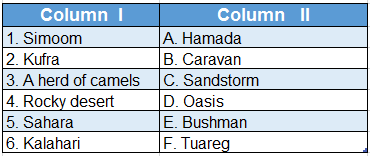
Answer: 1. C, 2. D, 3. B, 4. A, 5. F, 6. E
Question 2. Match the following:
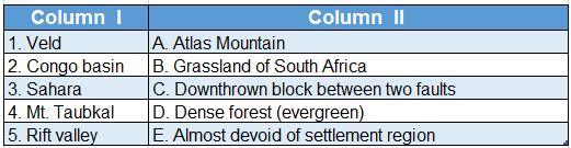
Answer: 1. B, 2. D, 3. E, 4. A, 5. C