
WBBSE Chapter 10 Continent Of Africa Topic B Nile Basin Long Question And Answers
Question 1. Describe the course of the River Nile.
Answer:
The course of River Nile:
The Nile is the longest river of the world. The length of the River Nile is 6650 km. According to physiography, the course of the Nile can be divided into 6 divisions. They are-
- Source region,
- The upper course of the river,
- The middle course of the river,
- The lower course of the river,
- Delta region.
1. Source region:
This region extends from the Burundi Highlands of Tanzania to Lake Victoria.
2. Upper course of the river:
This region extends from Lake Victoria to Malakal of Sudan. Several huge waterbodies have also formed in this region.
3. Middle course of the river:
This region extends from Malakal to Khartoum. It is a region of undulating stretch of Savanna Grassland.
Read And Learn Also WBBSE Solutions For Class 7 Geography
4. Lower course of the river:
This division extends from Aswan to Cairo, both in Egypt. The river descends in six steps, forming six waterfalls.
5. Delta region:
The delta course of the Nile River forms from Cairo to the Medi- terranean Sea. The discharge of the river gets divided into seven distributaries over here. This region is an agriculturally fertile alluvial plain.

Question 2. Delineate the course of the River Nile through a picture.
Answer:
The course of the River Nile through a picture:
Question 3. How important is irrigation for agriculture in Egypt?
Answer:
Importance of irrigation for agriculture in Egypt:
- The average annual rainfall in Egypt is less than 25 cm. But as the sources region of the Nile receives heavy rainfall, floods are experienced in Egypt.
- As a result of this, the arid region of Egypt also gets covered by silt and agriculture becomes possible. Agriculture in Egypt has become one of the main sources of livelihood.
- The major reason behind this is the fertile silt, deposited by the Nile and the irrigation facility that is available along the course of the river. As a result, high-quality cotton, wheat, banana, tobacco, millet, almond and such other crops grow here.
- The Aswan High Dam reaps massive benefits to the Egyptian economy. The annual Nile flood could be controlled by man, for the first time in history after the Aswan Dam was built.
- The floodwater is stored in the reservoir, with a scope to utilise it for irrigation, to increase the navigability of the Aswan Dam and to generate an enormous amount of hydel electricity. All these facilities, together lead to the development of agriculture.
Question 4. What is a multipurpose river valley project? What are the main objectives of such a project on the River Nile?
Answer:
Multipurpose River Valley Project:
When a dam is built on a river with many objectives, it is known as a multipurpose river valley project. For example, Aswan High Dam on the River Nile, Maithon Dam on the River Barakar, etc.
Objectives of the Multipurpose River Valley Project:
The objectives of the multipurpose river valley project are as follows-
- Irrigation system: Canals are dug from the reservoir to irrigate the agricultural lands of the river basin throughout the year.
- Flood control: Reservoirs are constructed to retain excess rainwater. As a result, the basin is protected from flooding.
- Hydropower generation: Hydropower is generated by turning water from the reservoir at high speed.
- Water transportation system: As there is water all year round in the main river and artificial canals, the facility of easy transportation is availed through waterways.
- Fish cultivation: Since reservoirs and canals are perennial all year round, fish farming can easily be done.
- Tourist centre: The dam and reservoir attract tourists from everywhere.
Question 5. Write about the minerals and industries of the Nile River Basin.
Answer:
Minerals of the Nile River Basin:
The Nile River Basin is not that rich in mineral deposits. However, certain minerals found in the region are-
Egypt: Mineral oil, mineral salt, gypsum, iron ore, phosphate, etc.
Sudan: Manganese, copper, iron ore, mica, etc.
Industries of the Nile River Basin:
Although the Nile River Basin is not rich in mineral deposits, yet
- Easy availability of agricultural raw materials,
- Developed transport network,
- Abundant availability of water,
- Easy availability of hydroelectricity,
- The easy availability of skilled labour has facilitated the development of various industries, of which the agricultural industries are prime.
For example, the cotton textile industry (Alexandria and Cairo), the meat processing industry (Sudan and Cairo), the paper industry, the cement industry, the woollen industry, the automobile industry, the leather industry (Alexandria, Sudan, Port Said), etc.
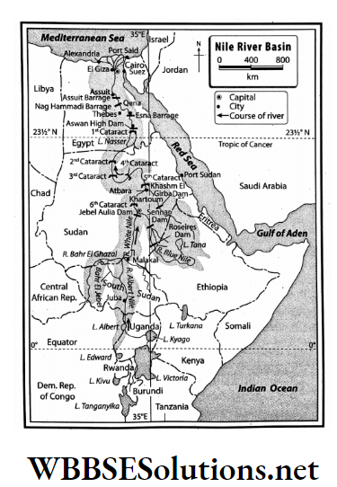
Question 11. Write a note on the Aswan High Dam.
Answer:
Aswan High Dam:
Aswan High Dam is a rock-fill dam that is 111 m high and 3830 m long in Aswan, Egypt. It was constructed at the cost of 1 billion dollars in 1970.
- Lake Nasser, the enormous reservoir, backs up the Nile about 320 km in Egypt and almost 160 km farther upstream in Sudan.
- The Aswan High Dam reaps massive benefits for the Egyptian economy.
- The annual Nile flood could be controlled by man, for the first time in history after the Aswan Dam was built.
- The flood water is stored in the reservoir, with scope to utilise this for irrigation, to increase the navigability of the Aswan Dam and to generate an enormous amount of hydel electricity. It also supports fishing.
Question 12. Describe the course of the River Nile.
Answer:
The course of the River Nile:
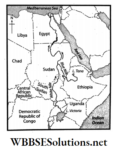
- Nile is the longest river of the world. The length of the River Nile is 6650 km. The White Nile and the Blue Nile join to form the River Nile.
- White Nile rises from the Burundi Highlands, which is 50 km away from Lake Tanganyika and Lake Victoria in Tanzania.
- On the other hand, the Blue Nile rises from the Ethiopian Highlands and meets the White Nile near Khartoum in Sudan.
- From here the Nile flows a long way through the deserts of Egypt and near Cairo, bifurcates into 7 distributaries. Here the Nile forms its exemplary delta and falls into the Mediterranean Sea.
Question 13. Draw a chart to state the reasons for the River Nile being perennial and flooding of the Nile Basin.
Answer:
The following chart explains the reasons for the River Nile being perennial and flooding of the Nile Basin.
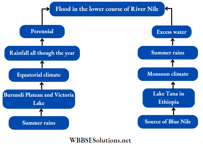
Question 14. Why is the Nile a perennial river?
Answer:
- The two major tributaries of the Nile are White Nile and the Blue Nile. The White Nile originates from Burundi Highlands and Lake Victoria.
- This river flows through the equatorial region and thus receives a good amount of rainfall.
- The Blue Nile originates from the Tana Lake in the highlands of Ethiopia. This river gets an adequate amount of rainfall as it flows through the region of monsoon climate.
- As these two rivers with adequate amounts of water join together to form the River Nile. Thus it is a perennial river.
Understanding the Nile River
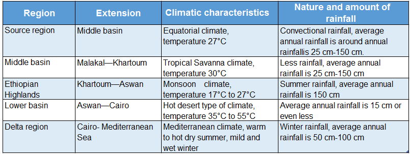
Question 15. Discuss the important climatic characteristics of the Nile River Basin.
Answer:
The important climatic characteristics of the Nile River basin are discussed in the following table:
Question 16. Find out the significance of river planning on agriculture in the Nile River Basin.
Answer:
The River Nile does not cause floods all through the year and so, agriculture becomes difficult in the dry seasons.
To manage this problem, river planning has been done and dams as well as reservoirs have been constructed on the tributaries of River Nile. These dams and reservoirs are listed as follows-
- Aswan Dam on the River Nile, with Nasser Lake to support it.
- Sennar Dam on the Blue Nile.
- Khashm el-Girba Dam on River Atbarah.
Apart from this, some other irrigation dams have also been constructed for the convenience of agriculture.
These are-
- Delta Barrage,
- Esna Barrage,
- Assiut Barrage.
Countless canals and minor sub-canals have been dug on either side of the river. Water is supplied to the floodplains of the Nile and even away from it through these canals to facilitate agricultural activities.
WBBSE Chapter 10 Continent Of Africa Topic B Nile Basin Short Question And Answers
Question 1. Why has the River Nile made the desert green in Egypt?
Answer:
- Almost 10% of the water flowing through the continent of Africa flows through the Nile. Two of its tributaries, the Blue Nile and the White Nile have made the desert green in Egypt.
- Dams built on the Nile have been effective enough to control flood, and water from these dams are then used for agriculture through canals.
- Agriculture flourishes in the delta region of the Nile due to rich silt deposition.
- Since Egypt is located in the lower course of the river, the desert region of Egypt has turned green due to the presence of the Nile.
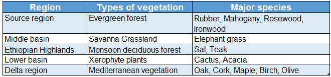
Question 2. Describe the natural vegetation cover of the Nile River Basin.
Answer:
The natural vegetation cover of the Nile River Basin is discussed in the following table-
Question 3. Name the most important agricultural crops of the Nile River Basin.
Answer:
- The most important agricultural crop of the Nile River Basin is cotton. In Egypt and Sudan huge quantities of long-staple cotton are grown. The cotton grown in this region has a huge demand in the international market.
- The other important crops of the region are- paddy, wheat, sugarcane, maize, tobacco, jowar, barley, almond and date. The major crops of the upper course of the river are tobacco, banana and coffee, etc.
- The crops of the middle course are wheat, date palm, jowar, almond, etc. The crops of lower course are olive, barley, maize, etc. The crops of the delta region are rice, wheat, cotton, etc.
Question 4. What measures can be taken to prevent the floodwater?
Answer:
- The River Nile gets flooded every year from the month of June of September. This excess floodwater needs to be stored separately, or else the lower course of the river will be completely flooded.
- Thus, several dams have been constructed on the course of the river. These dams hold the excess floodwater and thus help in controlling floods.
- The water from the dams is then diverted to the dry agricultural fields to facilitate irrigation in the arid regions. Thus, in addition to flood control, agricultural activities are also enhanced.
- At times, deep cavities are dug in the river basin to facilitate the entrance of floodwater underground and thus increase the groundwater level of the region.
Question 5. Briefly describe the permanent irrigation system of the Nile River Basin.
Answer
The permanent irrigation system of the Nile River Basin:
- The dams, the reservoirs and the irrigation dams constructed on the course of the River Nile (Assiut Barrage, Aswan Dam, etc.) supply water for irrigation through the canals.
- Moreover cavities have been formed to store the excess flood water.
- During the dry seasons, when the water level falls and there is a lack of water, water is drawing out from these with the help of the Persian Wheel and Swinging Basket.
- In this way, permanent irrigation and agriculture is made possible, not only in the floodplains but also away from them.
Question 6. Why is the Nile River Basin industrially developed?
Answer:
The most important reasons industrialisation of the Nile River Basin are-
- The raw materials (like cotton) for agro-based industry are grown in the Nile River Basin, due to good irrigation facilities.
- The dams constructed on the course of the Nile generate a huge amount of hydel power.
- A considerable stretch of the Nile (1500 km approx.) is navigable.
- Easy availability of labour.
- The commodities produced by these industries enjoy a good demand in the local as well as in the international market.
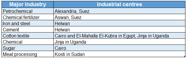
Question 7. Briefly mention the major industries of the Nile River Basin.
Answer:
The major industries of the Nile River Basin are as follows-
Question 8. Why are the banks of the River Nile so densely populated?
Answer:
The banks of the River Nile are densely populated due to the following reasons-
1. Agriculture:
- The banks of the river have been formed by rich silt deposition brought down by the river. This makes the banks fertile and facilitates easy agriculture with the help of river water for irrigation.
- This possibility of agriculture attracts population and settlement on the river banks.
2. Industry:
Although the region is not abundantly rich in mineral deposits, abundant agricultural production, easy availability of hydel power, and other factors create the possibility of establishing industries, which in turn attracts population and settlement on the river banks.
3. Transport network:
- The river course is navigable up to a length of 1500 km.
- The delta region and the cities are well connected by roadways and railways.
- The existence of the Suez Canal has brought a remarkable change in the connectivity network and thus attracts settlement here.
Question 9. Collect information about the influence of the River Nile on the livelihood of the people of the Nile Basin and form your own idea about it.
Answer:
The influence of the River Nile on the livelihood of the people of the Nile Basin are as follows-
- Source of drinking water: People living in the Nile Basin use the river as a potential source of drinking water.
- Formation of floodplain: Every year during summer floodplains form on either bank of the river as an action of flood. These floodplains are very fertile for agricultural production.
- As a Waterway: The River Nile is navigable for a stretch of 1500 km and thus can be used as an easy route of transportation.
- 4. Generation of hydel power: Dams have been built on the Nile to store water, and hydel power is generated from that water.
Usage in Industries: The water of the River Nile is used in various industries of the basin area for various purposes.
Question 10. Which countries are located in the Nile River Basin?
Answer:
- River Nile (6650 km), the longest river of the world, flows through the continent of Africa. River Nile flows through the Middle East part of Africa from south to north.
- As a result of this, many countries of central, eastern and northern Africa come under the Nile River Basin.
- Some of the most important countries that come under the Nile River Basin are Egypt, South Sudan, Ethiopia, Uganda, Kenya, Tanzania, Burundi, Rwanda, the Republic of Congo, Sudan and Eritrea.
- Among these, Egypt and Sudan alone cover almost 75% of the Nile River Basin.
Question 11. Write a note on Cairo.
Answer:
Cairo:
- Cairo, meaning ‘the victorious’ in Arabic, is one of the largest cities of Africa and the capital of Egypt. Cairo located on the eastern shore of the Nile marks the gateway of the Nile Delta.
- Along with its rich heritage, the metropolis of Cairo is associated with the location of the Criza Pyramid complex at its southwestern edge and the site of Heliopolis in the northeast, where Plato once studied.
- The Al-Azhar University of Cairo is the chief learning centre for Arabic and Islam.
Question 12. Write a short note on Alexandria.
Answer:
Alexandria:
- About 183 km northwest of Cairo in lower Egypt lies the city of Alexandria by the Mediterranean Sea at the western edge of the Nile.
- The second largest city and the principal seaport, Alexandria is a major industrial centre of Egypt.
- It serves almost 80% of the Egypt’s imports and exports. Its importance as an industrial centre is reflected by the natural gas and oil pipelines from Suez. It is also an important tourism centre.
Question 13. Write a short note on Port Said.
Answer:
Port Said:
- Port Said is a port city located in northeastern Egypt, at the northern end of the Suez Canal, on a low sandy strip separating the Mediterranean sea from Lake Manzala.
- Founded in 1859, the port city became Egypt’s chief port after Alexandria.
- Added to the port’s fishing facilities and frozen seafood plant, it also is a major export centre for cotton and rice.
- The city’s manufacturing centres produce textiles, glass, automobile batteries and tyres, watches, computers, cosmetics, etc.
- It also has numerous gas-fired electrical generating plants as well as shipyard facilities.
Question 14. Write any two characteristics of the River Nile.
Answer:
Two most important characteristics of the River Nile are-
- This is a river that flows through four different climatic regions,- equatorial, tropical Savanna, hot desert and Mediterranean.
- The Nile is an ideal river. From Lake Victoria to Malakal is the upper course of the Nile, then Malakal to Khartoum marks the middle course and lastly, from Aswan to Cairo is the lower course of the Nile. Cairo to the Mediterranean Sea is the delta region.
Question 15. Describe briefly the city of Khartoum.
Answer:
Khartoum:
- Khartoum is the capital and the second-largest city of the Republic of Sudan. White Nile and the Blue Nile confluence near Khartoum and form the River Nile.
- The highest density of commercial activities of the country is in Khartoum.
- The major industries of the city lists to printing, glass manufacturing, food processing, textiles and most importantly petroleum products.
Question 16. Give a brief description of the White Nile.
Answer:
White Nile:
- River White Nile stretches between Malakal to Khartoum, where it meets the Blue Nile to form the River Nile.
- The wide and shallow section of the White Nile flows along a small slope and is frequently fringed by swamps.
- The White Nile along with its major tributaries covers a length of 3700 km.
Question 17. Why do floods occur on the River Nile during summer?
Answer:
- The White Nile and the Blue Nile together join to form the longest river of the world-River Nile.
- The upper course of the Blue Nile originates from the Ethiopian Highlands, which receives heavy monsoon rainfall during summer.
- This excess water that flows into the course of the Blue Nile, in the summer months, results in a spate of water at the confluence of the White Nile and the Blue Nile.
- Thus water overflows the banks and subsequently leads to flood that occurs in the lower course of the Nile basin.
Question 18. What are the two main purposes of the construction of the Aswan Dam on the River Nile?
Answer:
The two main purposes of the construction of Aswan Dam on the River Nile are-
- Flood control and
- Irrigation of agricultural lands
WBBSE Chapter 10 Continent Of Africa Topic B Nile Basin Very Short Question And Answers
Question 1. Which region is called ‘the Gift of the Nile’?
Answer: Egypt.
Question 2. What is the source of the Blue Nile?
Answer: Tana Lake of Ethiopia Highland.
Question 3. Which is the longest tributary of the River Nile?
Answer: White Nile.
Question 4. Name the city that is located at the confluence of the White Nile and the Blue Nile.
Answer: Khartoum.
Question 5. What is the major commercial crop of Egypt and Sudan?
Answer: Cotton.
Question 6. Name the largest dam of the world.
Answer: Upper Aswan Dam (Egypt).
Question 7. On which river the Atabara Dam has been constructed?
Answer: Blue Nile in Sudan.
Question 8. Which is the most populous part of Egypt?
Answer: Delta region of Egypt.
Question 9. Name the capital city of Egypt.
Answer: Cairo.
Question 10. What is Egyptian cotton?
Answer:
Egyptian cotton:
Long-fibrous cotton is cultivated in the delta region of the Nile. The quality of this cotton is good as it has long fibres. This cotton is known as Egyptian cotton all over the world
Question 11. Mention the names of the dams built on the River Nile.
Answer:
The dams built on the River Nile are- upper Aswan Dam, Nag Hamadi Dam, Lake Nasser Dam, Assuit Dam, Esna Dam etc.
Question 12. Mention the names of the dams built on the Blue Nile.
Answer:
The dams built on the River Blue Nile are Jebel Aulia Dam, Senar Dam, Atbara Dam, etc.
WBBSE Chapter 10 Continent Of Africa Topic B Nile Basin True Or False
Question 1. Egypt and Sudan cover 75% of the Nile River Basin.
Answer: True
Question 2. The course of the River Nile is known as Bahr-el- Ghazal till Malakal in Sudan.
Answer: False
Question 3. The source of the White Nile lies in the Tana Lake of the Ethiopian Highlands.
Answer: False
Question 4. Khartoum is the capital of Sudan.
Answer: True
Question 5. The River Atbara originates from the Ethiopian Highlands.
Answer: True
Question 6. The middle course of the River Nile starts from Cairo.
Answer: False
Question 7. The major commercial crop of Egypt and Sudan is paddy.
Answer: False
Question 8. Nasser Lake is located behind the Aswan Dam.
Answer: True
Question 9. The Ethiopian Highlands in the Nile River Basin experience equatorial climate.
Answer: False
Question 10. Egypt is also known as the ‘Gift of Sahara’.
Answer: False
Question 11. Helwan in Egypt is an important iron and steel industrial region.
Answer: True
WBBSE Chapter 10 Continent Of Africa Topic B Nile Basin Fill In The Blanks
Question 1. The longest head-stream of the river Nile is known as __________.
Answer: Kagera
Question 2. __________ is the largest freshwater lake in Africa.
Answer: Victoria
Question 3. Six __________ are present on the course of the River Nile from Khartoum to Aswan.
Answer: Cataracts
Question 4. The River Nile flows from the __________ to the north direction.
Answer: South
Question 5. The longest tributary of the River Nile is __________.
Answer: White Nile
Question 6. The most significant commercial crop grown in the delta region of the River Nile is __________.
Answer: Cotton
Question 7. Long-fibered __________ is grown in the river basin of the Nile.
Answer: Cotton
Question 8. A famous multipurpose dam in Egypt on the Nile is the __________.
Answer: Aswan Dam
Question 9. Lake __________ is located behind the Aswan Dam.
Answer: Nasser
Question 10. __________ is the largest port of Egypt.
Answer: Alexandria port
Question 11. __________ is the capital of Egypt.
Answer: Cairo
WBBSE Chapter 10 Continent Of Africa Topic B Nile Basin Match The Columns
Question 1.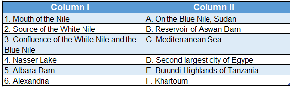
Answer: 1. C, 2. E, 3. F, 4. B, 5. A, 6. D